A 30-mile Active Transportation Corridor. Technical Report. Prepared For: Prepared By:
|
|
|
- Marshall Armstrong
- 5 years ago
- Views:
Transcription


1 A 30-mile Active Transportation Corridor Technical Report Prepared For: Prepared By: August 2013
2 Acknowledgements The Jurisdictions of Mooresville, Davidson, Cornelius, Huntersville, Charlotte; and Iredell and Mecklenburg Counties; greatly appreciate the efforts of the numerous stakeholders and citizens who participated in the development of this study. Their creativity, energy, and commitment to the future of the Mooresville to Charlotte Trail were the driving force behind this effort. The following stakeholders, staff, and other agency and organization members contributed significantly to the development of the Mooresville to Charlotte Trail Feasibility Study. Stakeholder Team Gwen Cook, Mecklenburg County Kevin Brickman, Mecklenburg County Karen Weston-Chien, Mecklenburg County Jay Higginbotham, Mecklenburg County Jack Simoneau, Town of Huntersville Daniel Stines, Town of Mooresville Neil Burke, Town of Mooresville Kathryn Spatz, Town of Davidson John DeKemper, Town of Cornelius Troy Fitzsimmons, Town of Cornelius Will Washam, Town of Cornelius Zac Gordon, Town of Huntersville Scott Treon, Town of Huntersville Geoff Steele, Huntersville Greenway, Trail & Bikeway Commission Dick Winters, Mecklenburg County Park and Recreation Greenway Advisory Council Kenneth Tippette, City of Charlotte Consultant Team Alta Planning + Design, Inc. John Cock, Principal in Charge Maya Agarwal, Designer Parsons Brinckerhoff Todd Steiss, Senior Planner Eric Gorman, Transportation Planner Bill Coxe, Town of Huntersville The Mecklenburg-Union Metropolitan Planning Organization (MUMPO) provided funding for this project through an allocation of its Section 104(f) Metropolitan Planning (MP) funds. Matching funds were provided by the jurisdictions indicated above. For inquiries, please contact Mecklenburg County Park and Recreation, Capital Planning Division, 5841 Brookshire Blvd, Charlotte, NC 28216, (704) i
3 Mooresville to Charlotte Trail Technical Report Table of Contents 1. Introduction Visualizing the Mooresville to Charlotte Trail Public Involvement Process Main Trail Alignment and Priority Trail Segments Preliminary Planning-Level Cost Opinions Next Steps Appendix I.... A-1 Appendix II... A-5 Appendix III... A-11 Appendix IV... A-17 Table of Figures Figure 1: The Mooresville to Charlotte Trail Conceptual Alignment Figure 2: Photosimulation One Figure 3: Photosimulation Two Figure 4: Chart of the Number of Comments per Workshop Figure 5: Chart of the Number of Comments per Subject Table 4-1: MCT Overview Lengths Table 4-2: Project Prioritization Figure 6: MCT Trail Alignment Overview Figure 7: MCT Priority Trail Segments: Northern Section Figure 8: MCT Priority Trail Segments: Middle Section Figure 9: MCT Priority Trail Segments: Southern Section ii
4 iii This page left intentionally blank.
5

6 1. Introduction The Mooresville to Charlotte Trail (MCT) is a proposed thirty-mile, multi-use trail that will extend from downtown Mooresville, North Carolina to Uptown Charlotte, North Carolina traveling through Davidson, Cornelius and Huntersville. The MCT will be located within Iredell and Mecklenburg Counties. The trail generally parallels the Norfolk Southern rail corridor and NC Highway 115, while generally staying outside of the Norfolk Southern right of way. The trail is envisioned as a paved trail, with a minimum 12 feet in width. The MCT is a standalone project, and can be planned and constructed whether or not any conceptual commuter rail exists within the corridor. The MCT is intended to connect to greenway trails identified in the master plans of the jurisdictions that the trail passes through, and will provide a non-motorized transportation and recreation option for trail users along the corridor. The trail is expected to be completed in segments, with priority sections that connect to proposed transit stations, key points of interests, and other large trip generation areas to be constructed first. The MCT planning process was first initiated in 2010 by a group of staff from seven jurisdictions: the Towns of Cornelius, Davidson, Huntersville and Mooresville; the City of Charlotte; and Iredell and Mecklenburg Counties. Staff members were joined by citizens interested in furthering the effort. Together, the initiative group created a conceptual trail alignment (depicted in Figure 1) for the corridor and prepared a memo that estimated that between 1.2 and 1.8 million user trips would be made annually on the trail (this model assumes a functioning commuter rail within the corridor). (At the time the initiative group prepared the memo, the group referred to the trail as the North Corridor Trail ; see reference memo in Appendix I). Presently the trail is known as the Mooresville to Charlotte Trail. To advance the planning process, in 2013 the group contracted with Alta Planning + Design, a bicycle, pedestrian, and trail planning and design consultant, and Parsons Brinckerhoff. A Mecklenburg-Union Metropolitan Planning Organization (MUMPO) grant funded the effort. This technical report highlights visuals that were created for key sections of the trail and summarizes the public input process that identified the preferred alignment of the MCT. The report also identifies near term priority projects and estimates the order of magnitude cost for the complete trail system. Attendees view the trail corridor at a public workshop in Charlotte. The MCT corridor serves as the study area. Greenway and other bicycle and pedestrian facilities that connect to the MCT within individual municipalities will be implemented through separate efforts. The initiative group intends for this study to reflect the best thinking and vision of government agencies and local stakeholders, including community and institutional representatives, and potential facility users. Gathering and condensing the thoughts and ideas of each of these entities into a single vision is critical to the success of this study. The consensus vision expressed in this document shall serve as a tool to guide the future development of the Mooresville to Charlotte Trail. 1-1

7 Mooresville to Charlotte Trail Technical Report Figure 1: The Mooresville to Charlotte Trail Conceptual Alignment Existing and proposed bike-ped facilities already adopted by local jurisdictions complement the MCT, providing potential for a significant, active transportation system. 1-2

8 2. Visualizing the Mooresville to Charlotte Trail The Mooresville to Charlotte Trail (MCT) represents a number of opportunities for the communities within which the trail corridor is located. When complete, the trail will become an amenity for the communities along the trail, stimulating economic development, promoting active modes of transportation and recreation, and improving the environmental quality of the region. As seen with similar trails in other cities, active transportation reduces harmful emissions while resulting in health and fitness benefits. Regional trail projects that travel through multiple communities can be difficult to communicate, thus the project team utilized a robust public outreach process (fully described in chapter 3 of this document) to enhance public understanding of the Mooresville to Charlotte Trail. The project team used state-of-the-art visuals and graphic simulations, including a video flyover of the trail system, to depict the potential trail corridor and its appearance. The video flyover displayed the proposed route of the Mooresville to Charlotte Trail, beginning in downtown Mooresville and then flying over the trail corridor, highlighting municipalities and key destinations along the way, terminating in Uptown Charlotte. The video was a helpful tool to depict the trail s alignment through varied land uses and development patterns. An image of the MCT video flyover is displayed below, and the complete video is available on the project website hosted by Mecklenburg County: The video flyover of the Mooresville to Charlotte Trail provides a unique perspective on the proposed trail route 2-3

9 Mooresville to Charlotte Trail Technical Report Photo Renderings of Potential Mooresville to Charlotte Trail The project team also used before-and-after renderings ( photosimulations ) to depict trail alignment and appearance at key locations, as depicted in Figures 2 and 3. Figure 2: The MCT will facilitate access to schools, shops, restaurants, and employment along the corridor. Existing conditions (above) and photo rendering (below) of MCT along Jackson Street in Davidson. 2-4

 near Norman Drive and the rail line in")
10 Figure 3: Gateways will provide a sense of identity along the Mooresville to Charlotte Trail system. Existing conditions (above) and photo rendering (below) near Norman Drive and the rail line in Mooresville. 2-5
11 This page left intentionally blank. 2-6

12 3. Public Involvement Process The Mooresville to Charlotte Trail is an ambitious project that travels through multiple communities. Without broad support from elected officials and the public along the corridor, the project s bold vision will likely not be fully realized. The Mooresville to Charlotte Trail planning process involved a robust public outreach process that provided invaluable information from agency representatives, residents, businesses and other key stakeholders for the entire length of the trail system. This chapter describes the process for obtaining public input. The planning team used various methods to solicit and receive feedback and direction during the planning process. Feedback from the public and stakeholders was then synthesized and ordered into logical categories. This chapter includes graphs and charts produced to help visualize the type of public comments provided. The public comments directly informed the planning team s identification of priority projects (see chapter 4). Website To keep the public up-to-date on the progress of the study, Mecklenburg County maintained a project website. The website provided information regarding the goals of the project, maps of potential routes and facilities, an MCT fact sheet, a link to the a flyover video of the trail system, meeting dates and times, presentations, and project contact information. Local municipalities provided convenient links from their respective websites to the Mecklenburg County site. The Mecklenburg County website served as the hub of information for the MCT during the planning process. 3-7

, City of Charlotte (April 10th, 2013), and Town of Cornelius (April 11th, 2013).")

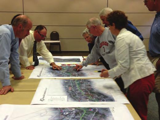
13 Mooresville to Charlotte Trail Technical Report Public Meetings In order to gather broad public input, the planning process included three public meetings. Prior to the meetings, the jurisdictions informed property owners near the Norfolk-Southern rail line by mailing approximately 1,300 postcards, issuing press releases to local media outlets and sending information through their contact lists. The three meetings were hosted at the following jurisdictions: Town of Mooresville (April 2 nd, 2013), City of Charlotte (April 10th, 2013), and Town of Cornelius (April 11th, 2013). The meeting sites were selected to take place mostly at convenient locations along the trail corridor in order to provide multiple opportunities for the public to attend and participate. Each of the public meetings followed a similar format. Postcards informed the public about the Mooresville to Charlotte Trail public meetings. Staff first welcomed attendees to the meeting, and asked each person to sign in. Each attendee received an agenda for the meeting, which included the project website, and contact information. Meeting atteendees discussing the proposed trail alignment at the Charlotte workshop. 3-8


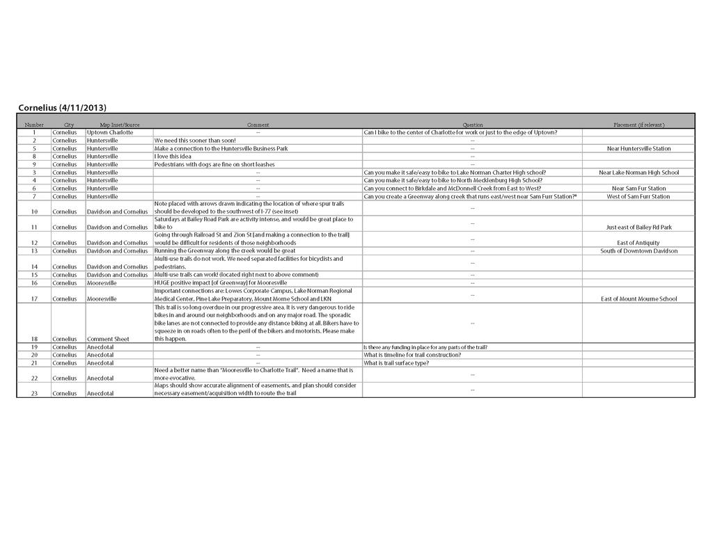
14 Agenda slips gave public meeting attendees an overview of each workshop. Staff and consultants encouraged attendees to ask questions and to visit stations set up around the room displaying the full, proposed MCT corridor. The public was encouraged to comment on the proposed corridor using markers and Post-It notes. Staff projected the MCT video flyover on the wall during the meetings. Mecklenburg County and local jurisdiction staff provided a brief presentation highlighting key aspects of the MCT. The presentation included examples of similar projects of the same scale that have been built in other American cities, and they have proven to be very popular and successful. The presentation displayed the proposed MCT alignment, and identified the many benefits of trails. Benefits include: connectivity, increased transportation opportunities, and linkages to proposed transit stations. Staff identified key next steps, including possible funding opportunities as well as the need for coordination between municipalities to incorporate the MCT into local bicycle and pedestrian master plans. The presentations ended with an open question and answer session. Town of Cornelius staff provided an overview presentation at the Cornelius workshop, held on April 11th. Attendees provided many posiitve comments and helpful insights regarding the proposed trail alignment. The project team recorded questions and comments made during the presentation, and invited meeting attendees to revisit the maps and continue discussions. The project team prepared and made available hardcopy comment sheets for use by any participant. Staff also received some comments via . The project team collected all comments, and synthesized them into charts grouped by meeting location and comment types. 3-9

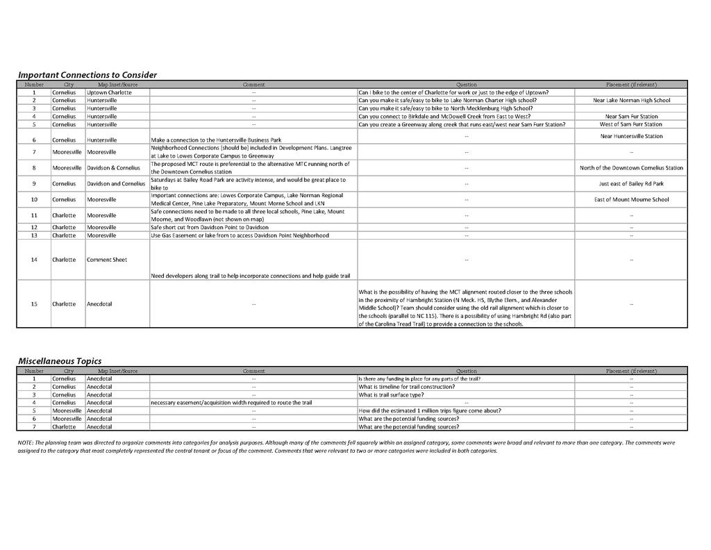
15 Mooresville to Charlotte Trail Technical Report Analysis of Public Comments The public workshops generated the majority of the public comments - these were primarily in the form of written comments by meeting attendees directly on the maps. Cornelius was the most well attended meeting, where 23 comments were collected, followed by 11 comments at the Charlotte workshop and 9 in Mooresville (see Figure 4). The project team organized comments into categories for analysis purposes. Although many of the comments fell squarely within an assigned category, some comments were broad and relevant to more than one category. The project team assigned comments to the category that most completely represented the central tenet or focus of the comment. Comments that were relevant to two or more categories were included in both categories. The enthusiasm of the Mooresville workshop can be summed up in the guiding principles posted by a meeting attendee, Prioritize it, Fund it, Build it. Public input was generally supportive of the goals and objectives of the Mooresville to Charlotte Trail and its proposed alignment. The planning team determined that comments could be grouped in one of four categories: Enthusiasm for the project (Enthusiasm), Suggestions to enhance the project (Suggestions), Safety Consideration (Safety), and Important Connections to consider (Connections), as well as one Miscellaneous category. Of the 43 comments collected, 20 percent indicated direct support for the trail project as proposed, nine percent of the comments provided suggestions to enhance the scope and goals of the MCT. Multiple respondents considered safety a priority, representing about 20 percent of the total comments. The largest category of comments was related to important trail connections, which represented about 35 percent of all the public input collected. Attendees review maps at the Mooresville public meeting. The project team compiled comments from each of the three public meetings, and organized them by both meeting location and topic. Two summary graphs compare the input of the different meeting locations and display the type of comments collected (See Figures 4 and 5). All of the comments are provided in Appendix II. 3-10


16 Number of Comments per Workshop Mooresville Charlotte Cornelius 5 0 Mooresville Charlotte Cornelius Figure 4: Number of Comments per Workshop Number of Comments per Subject Enthusiasm Suggestions Safety Connections Misc. Figure 5 : Number of Comments per Subject 3-11
17 Mooresville to Charlotte Trail Technical Report This page left intentionally blank. 3-12
18 4. Main Trail Alignment and Priority Trail Segments Main Trail Alignment Based on the vision of the MCT project, feedback received from the public process, and jurisdiction preference, the project team developed a recommended a primary ( main ) alignment for the Mooresville to Charlotte Trail. The project team paid close attention to public, stakeholder, and jurisdiction stated preferences for a separated, off-road, paved, multiuse trail (either a greenway or a sidepath). The team also identified alternate alignments for some sections, with the understanding that a master plan is a living document, and as opportunities present themselves in the future, alignments other than the main alignment may be utilized. An overview of MCT lengths is provided below: MCT Trail Sections Length (miles) Iredell County 5.0 Mecklenburg County 17.3 Subtotal 22.3 Existing Greenways Irwin Creek Greenway 0.8 Subtotal 0.8 Planned Greenways Nevin Park to Irwin Creek Greenway 6.3 Irwin Creek Greenway to Cedar St 0.3 Subtotal 0.3 Total MCT Length 29.8 Note: Includes only main trail sections. Table 4-1: MCT Overview Lengths 4-13
19 Mooresville to Charlotte Trail Technical Report Near Term Priority and Long Term Projects Within the MCT preferred alignment, the team divided the Mooresville to Charlotte Trail corridor into logical trail segments, based on consensus of the jurisdiction representatives. Because the MCT is a long-term vision and a large project, the MCT will be constructed in phases. To begin to determine phasing of the MCT, the team set about determining which of those logical trail segments should be considered near term priority or long term projects. To determine which trail segments would be considered near term priority segments, the project team used a prioritization matrix as an evaluation tool. This technique allows network planners to consider a number of factors when assessing project prioritization, including political feasibility, logistics, environmental impact and transportation outcomes. The team worked with each of the jurisdictions to develop the criteria that would identify which trail segments should be considered near term priority trail segments. In each jurisdiction, the project team considers higher-scoring projects near-term priority projects, and lowerscoring projects long term projects. Prioritization criteria include: Public Support Active Travel Demand Connectivity Development Costs Environmental Impact/Permitting Requirements Agency Coordination/Acquisition Equity Scenic Quality and Experience A summary of priority projects is given in Table 4-2. The detailed project matrix and prioritization methodology are provided in Appendix III. Mooresville to Charlotte Main Trail Alignment and Priority Segment Maps Overall and detail maps of the main and alternate alignments of the MCT corridor, with near term priority and long term projects identified, are provided in Figures 6 through 9. Additional facilities throughout the corridor, such as schools, parks, residential developments, major commercial centers, and existing greenways can be viewed on the MCT project website maps at: Multiuse Trail (Greenway) refers to a paved trail that is separate from a roadway, outside of the road rightof-way. Multiuse Trail (Sidepath) refers to a paved trail that is separate from a roadway, but within or just outside of (and generally paralleling) the road right-of-way. Neighborhood Greenways refers to routes within a roadway that are designated and designed to give bicycle and pedestrian travel priority. Treatments may include signs, pavement markings, and speed and volume management measures to create safe, convenient bicycle and pedestrian access and crossings. The clear preference throughout the corridor is for the MCT to be a multiuse trail, but neighborhood greenways may occur in conjunction with constrained 4-14
20 conditions or other factors. Numbers on the maps correspond to trail segments. Any project that may be chosen for implementation will depend upon public input, availability of funding, detailed design and engineering study, and negotiations with affected property owners. Some example images of different types of potential facilities in different conditions are depicted on the next page. Priority Level Description of Factor TOTAL (Max 100) Proposed Segment Mooresville Near term Downtown Mooresville to Pine Lake Preparatory School 68 Long term Langtree Station to Mooresville town limits 67 Davidson Long term Mooresville town limits to Davidson Station 57 Near term Davidson Station to Davidson town limits 70 Cornelius Near term Davidson town limits to Cornelius Station 73 Long term Cornelius Station to Cornelius town limits 57 Huntersville and Charlotte Long term Cornelius Town limits to Huntersville Station 68 Near term Huntersville Station to Eastfield Road 72 Long term Eastfield Road to Hucks Road 64 Charlotte Long term Hucks Road to north end of Nevin Park (near intersection of 62 Garvin Dr. and Oak Dr.) Near term Irwin Creek Gwy- Nevin Park to Allen Hills 90 Neighborhood Park (immediately south of Nevin Rd.) Near term Irwin Creek Gwy- Allen Hills Park to Statesville Ave 81 Near term Irwin Creek Gwy- Statesville Ave to Hamilton St 81 Near term Irwin Creek Gwy- Hamilton St to Rays Splash Planet 67 Note: Sections are identified by proposed rail transit stations, jurisdiction border, or particular facilities. Actual projects will be planned to functional limits, such as roadways. Table 4-2: Project Prioritization 4-15
 is located within or near a road")
 is often located in natural environments and provides")

21 Mooresville to Charlotte Trail Technical Report Primary Trail Types A multiuse trail (sidepath) is located within or near a road right-of-way and provides separation from traffic A multiuse trail (greenway) is often located in natural environments and provides separation from traffic Neighborhood greenways along low volume, low-speed roadways can accommodate both cyclists and pedestrians in more constrained conditions 4-16

22 Figure 6 : MCT Trail Alignment Overview 4-17

23 Mooresville to Charlotte Trail Technical Report Figure 7 : MCT Priority Trail Segments: Northern Section 4-18

24 Figure 8 : MCT Priority Trail Segments: Middle Section 4-19

25 Mooresville to Charlotte Trail Technical Report Figure 9 : MCT Priority Trail Segments: Southern Section 4-20
26 5. Preliminary Planning-Level Cost Opinions The project team prepared preliminary planning-level construction costs opinions based upon the proposed Mooresville to Charlotte Trail corridor. Important assumptions used to arrive at these preliminary cost opinions include the following: All costs are in 2013 dollars (no adjustments for inflation) Cost opinions include both construction costs and land acquisition Cost opinions include both near term priority and long term projects Right-of-way (ROW) costs represent land only (no structures) No cost for publically owned land Trail will be 12 feet wide and paved 30 to 50 foot wide easement or portion of a parcel required for trail Cost could be reduced with granted easements Cost could increase if additional ROW is needed or an entire parcel must be purchased Construction methods and materials typical for the region are used Overcrossing of WT Harris Boulevard In developing the preliminary cost opinions, the project team relied upon its experience with similar greenway projects to select the construction materials with the best life-cycle cost/performance characteristics. The consultant team also used Mecklenburg County s recent greenway costs for some cost estimating numbers. The project team developed a cost estimate for both a 30-foot ROW and a 50-foot ROW, which provide a cost range between approximately $33.1 million, using near-term improvements and low end site-specific costs (areas with anticipated design challenges such as the need for bridges or road crossings) within a 30-foot of ROW, and a maximum of $36.8 million with long-term improvements and high end site-specific costs within a 50-foot ROW. A summary of preliminary cost opinions are provided in the following table, and detailed preliminary cost opinions are provided in Appendix IV. Assumed ROW Width ROW Costs Opinion of Total MCT Project Cost Near Term Long Term 30 foot ROW $1,369,000 $2,250,000 $33,142, foot ROW $2,264,000 $3,793,000 $36,840,000 *ROW Costs = Construction + Site Specific Costs 5-21
27 Mooresville to Charlotte Trail Technical Report This page left intentionally blank. 5-22
28 6. Next Steps Adopt the Mooresville to Charlotte Trail Master Plan Before any other action takes place, the jurisdictions should adopt the MCT master plan corridor as identified in this master plan. This formal adoption should be considered the first step in implementation. Through adoption of this master plan and its accompanying maps, the jurisdictions will be better able to shape transportation and development decisions so that they fit with the goals of the MCT. Most importantly, having an adopted master plan is extremely helpful in securing funding from state, federal, and private agencies. Adopting this master plan does not commit the jurisdictions to dedicate or allocate funds, but rather indicates the intent of the jurisdictions to implement the MCT over time, starting with these action steps. Seek Multiple Funding Sources and Facility Development Options The jurisdictions are planning some sections of the MCT for implementation, and some sections may be built by developers. It is important to secure the funding necessary to undertake priority projects but also to develop a long-term funding strategy to allow continued development of the overall project. A priority action is to immediately evaluate the recommendations against transportation projects that are currently programmed in the Transportation Improvement Program (TIP) to see where projects overlap, complement, or conflict with each other. The jurisdictions should also evaluate which of the proposed projects could be added to future TIP updates. Capital and local funds for MCT trail construction should be set aside every year, even if only for a small amount. Small amounts of local funding can be matched to outside funding sources or could be used to enhance NCDOT projects with bicycle or pedestrian features that may otherwise not be budgeted for by the state. A variety of local, state, and federal options and sources exist and should be pursued, including the option for implementing the entire MCT corridor as a single project. This could be done through a federal or state funding source such as TIGER grants. Packaging the project as a single project for NCDOT funding should be considered as an option. NCDOT has funded other active transportation projects of similar scope. Seek Key Project Partners Coordination between key project partners will establish a system of checks and balances, provide a level of accountability, and ensure that the MCT s vision is implemented. The jurisdictions should seek project partners (such as the Carolina Thread Trail, hospitals, and schools) and sponsors (including private corporations or foundations). The purpose of this collaboration with key project partners is to ensure that the MCT s recommendations are integrated with other transportation planning efforts in the region, as well as long-range and current land use planning, economic development planning, and environmental planning efforts. Partners should work together to identify and secure funding necessary to immediately begin the near term priority projects, and start working on a funding strategy that will allow the jurisdictions to incrementally complete the MCT. Establish a Compelling Project Name Project partners should develop a compelling project name and branding strategy for the MCT. The branding strategy will be instrumental in seeking recognition, funding, and support throughout the community. 6-23
29 Mooresville to Charlotte Trail Technical Report Branding should also be used to develop a comprehensive graphic and wayfinding system that can be used throughout the corridor (including alternate alignment sections along existing corridors until the final, main corridor is built). Develop Detailed Cost Estimates and Preliminary Designs and Impact Studies The planning level design concepts and cost opinions contained in this report are intended to provide a rough estimate of potential project costs. As the MCT project progresses, the jurisdictions should develop more detailed designs and cost estimates for specific sections of the trail. In addition, studies which detail the beneficial economic and health impacts of the MC Trail may be helpful in developing grant applications and seeking public and private support and partnerships for the trail. 6-24
30 Appendix I. Demand Model (2011) A-1
31 Mooresville to Charlotte Trail Technical Report North Corridor Rail-with-Trail Demand Model As conceived, the North Corridor Rail-with-Trail will be approximately 30 miles in length. Serving both transportation and recreation needs and appealing to residents and visitors alike, it is estimated that between 1.2 and 1.8 million user trips will be made annually on the trail. Methodology Alta Planning + Design s National Bicycle and Pedestrian Documentation (NBPD) Project trail usage model was modified with regionally specific information provided the 2009 American Community Survey (ACS) population by Census tract. Data from the ACS were used to determine the population adjacent to the proposed trail and the regional population surrounding it. Residents who live within a half-mile of the trail are likely to use the facility more frequently than the surrounding community. Residents will also travel to visit the trail; this model uses a 20 mile radius for further use. The model incorporates information about the quality of the future trail and the area climate to estimate the number of trips per year. Next Steps This analysis could be expanded to integrate any available count data from nearby or similar trail facilities. It could include information about mode split (approximate number of bicyclists and pedestrians), as well as gender. Additional analysis could also consider the trail benefits to the community. While health benefits are difficult to quantify, several studies have developed methodologies for estimating economic benefits based on expectations about user behavior. Other benefits consider the reduction in vehicle miles traveled (VMT) as residents and visitors replace driving trips with a trip along the trail. A-2

32 This page left intentionally blank A-3
33 Mooresville to Charlotte Trail Technical Report This page left intentionally blank A-4
34 Appendix II Public Comment Data A-5

35 Mooresville to Charlotte Trail Technical Report A-6
36 A-7

37 Mooresville to Charlotte Trail Technical Report A-8
38 A-9

39 Mooresville to Charlotte Trail Technical Report A-10
40 Appendix III Prioritization Matrix and Method A-11
41 Mooresville to Charlotte Trail Technical Report Priority Project Evaluation - Methodology Criteria Selection Several principles govern the selection of criteria for the Mooresville to Charlotte Trail project priority evaluation. These include: breadth of topics, measurability and data access, and applicability to MCT context. Breadth of Topics The project team sought variables which reflected conditions and outcomes across a wide range of areas, including cost, feasibility, system performance, social outcomes and environmental impacts. The eight themes selected are included below. For each theme, the evaluation assesses several sub-variables. Factor Category Points Available Public Support 20 Agency Coordination/Acquisition 15 Connectivity 15 Development Costs 15 Active Travel Demand 10 Equity 10 Scenic Quality and Experience 8 Environmental Impact/Permitting Requirements 7 All factors 100 Measurability (and Data Access) A key consideration for criteria selection is the accuracy with which the factor can be measured not necessarily in quantitative terms, but in terms of how readily it can be compared across all trail segments. For instance, the category Scenic Quality and Experience is challenging to measure quantitatively, yet is relatively straightforward to assess using an eyeball approach that considers proximity to roadways and degree of forest canopy. Visibility of Trail, for example, is given a weight of 3, and trail segments receive a 3 if they are near roadways and developed land, and have relatively low tree coverage, and a weight of 1 if they are removed from roadways and routed through forested areas. In some cases, low scores in one category are associated with high scores in another. For example, trail segments scoring highly in Visibility of Trail tend to score lower in Not located near motor vehicle traffic and Provides a typical woodland greenway experience, since the latter two categories reward trail segments in natural settings that generally have low visibility to those not using the trail. This is a reflection of natural spillover between themes, and is actually an advantage of the project prioritization matrix technique. Competing or complementary variables are assessed individually and, when weighted appropriately, result in a synthesized index of overall priority level. A-12
42 Applicability to MCT Context Variables selected for the prioritization matrix must be relevant to route geography and local context. For instance, because the proposed MCT trail runs through a relatively flat part of the region and is adjacent to a railroad, the evaluation assumes that topographic challenges were limited. As a result, the evaluation weights topography lightly, accounting for three points out of 100. Other variables, such as the number of road and driveway crossings and the number of on-road segments, are considered more relevant to the proposed trail corridor (due to greater variability between trail segments) and are weighted accordingly (five points for both crossings and on-road segments). Factors also need to reflect local context in terms of agency coordination and support. For this reason, variables such as Priority Segment are included which reflect the priorities of each jurisdiction. The evaluation includes variables such as lies within existing public property or easement because they reflect jurisdictional preferences and realities, and effectively differentiate trail segments. Assessment Approach Weighting and scoring system Rather than rating each category using the same rubric (e.g. out of 10) and then scaling the results through multiplication factors, this analysis begins by assigning a maximum score to each category. The range of maximum scores varies from 2 to 15. The maximum score for each category (i.e. weight) was determined through a review of prioritization matrices for previous projects, and in consultation with stakeholders and jurisdiction representatives. Assigning maximum scores for each variable effectively serves as a weight. Priority segments (max. 15 points) and lies within existing public property or easement (max. 10 points) have a greater bearing on a trail segment s overall score than Few topographic challenges (max. 3 points) and not located near other sources of air and noise pollution (max. 2 points). One reason to assign weights in this way is for simplicity. The matrix was developed so that a perfect score would equal 100. Category scores were adjusted in such a way that each category was 1) suitably weighted relative to other categories and 2) summed to 100. Rating of alternatives The prioritization analysis uses several techniques to evaluate each theme. Some topics are eyeballed i.e. the score represents a qualitative assessment, expressed as a number. For variables evaluated in this way, a consistent framework is applied across trail segments. For instance, on links community origins and destinations, which is scored out of five, segments receive either a 5, 3 or 1 depending on the level of connectivity with community origins and destinations. In other cases, such as not located near motor vehicle traffic (scored out of 2), links receive a 2, 1 or 0. The evaluation applies a consistent rubric for all qualitative variables to all trail segments. A-13
43 Mooresville to Charlotte Trail Technical Report Some categories are based on quantitative comparisons, and in these cases surrogate variables are established: Initial Usage = Municipal population Potential Usage = County population growth, Serves lower income areas = Poverty rate relative to NC average Serves the widest range of users = Combined % of seniors and youth Each of these surrogate variables intends to accurately represent a broader theme. Since these variables produce continuous data (e.g. poverty rates expressed as a percentage), the results need to be translated into the pseudo-numerical format of the prioritization matrix. In the example of serves lower income areas, which is scored out of 5, poverty rates are derived for each municipality and compared with state averages. Three of the five municipalities Davidson, Cornelius and Huntersville have poverty rates relatively close to the North Carolina average, and are thus assigned mid-point scores of 3. Charlotte, with a higher-than-average poverty rate, receives a 5, while Mooresville, with a lower-than-average poverty rate, scores a 1. This workflow is representative of the analysis for the other three variables listed above, and describes, in general terms, the process for scoring all matrix variables. A-14
44 A-15
45 Mooresville to Charlotte Trail Technical Report This page left intentionally blank A-16
46 Appendix IV Preliminary Planning-Level Cost Opinions Detail: 30 and 50 ROW A-17
47 Mooresville to Charlotte Trail Technical Report This page left intentionally blank A-18
48 A-19

49 Mooresville to Charlotte Trail Technical Report A-20
50 A-21

51 Mooresville to Charlotte Trail Technical Report A-22
Welcome to the first Community Workshop for Wesley Heights Greenway Cedar Street to Bruns Avenue
 Welcome to the first Community Workshop for Wesley Heights Greenway Cedar Street to Bruns Avenue What is a Greenway? Active Transportation Linear Public Park Recreation Health and Fitness Desirable Amenity
Comprehensive Plan ADOPTED APRIL 2014
 Comprehensive Plan ADOPTED APRIL 2014 8 8. Outstanding Recreational & Cultural Opportunities We are proud of our community s parks and recreation system. Our community will ensure that the legacy of our
Scope of Services. River Oaks Boulevard (SH 183) Corridor Master Plan
 Corridor Master Plan") Scope of Services River Oaks Boulevard (SH 183) Corridor Master Plan PROJECT AREA The project area consists of the River Oaks Boulevard (SH 183) corridor bounded by SH 199 at the northern end and the Trinity
Scope of Services River Oaks Boulevard (SH 183) Corridor Master Plan PROJECT AREA The project area consists of the River Oaks Boulevard (SH 183) corridor bounded by SH 199 at the northern end and the Trinity
The Illinois Department of Transportation and Lake County Division of Transportation. Route 173, including the Millburn Bypass
 The Illinois Department of Transportation and Lake County Division of Transportation welcome you to this Public Hearing for U.S. Route 45 from Illinois Route 132 to Illinois Route 173, including the Millburn
PLANNING COORDINATING COMMITTEE
 PLANNING COORDINATING COMMITTEE Fall Meeting/Luncheon Welcome! October 16, 2009 PLANNING COORDINATING COMMITTEE Fall Meeting/Luncheon WELCOME! WELCOME! October 16, 2009 October 16, 2009 Agenda I. Lunch/Socialize
Yadkin River Greenway Feasibility Study Fact Sheet Village of Clemmons, Town of Lewisville, Town of Bermuda Run
 Fact Sheet Village of Clemmons, Town of Lewisville, Town of Bermuda Run Project Background The Yadkin River Greenway Feasibility Study is a joint project with the Village of Clemmons, the Town of Bermuda
December 1, 2014 (revised) Preliminary Report -- Thomas Jefferson Site Evaluation
 Preliminary Report -- Thomas Jefferson Site Evaluation") December 1, 2014 (revised) TO: FROM: RE Arlington County Board Thomas Jefferson Site Evaluation Working Group by Carrie Johnson, Chair Preliminary Report -- Thomas Jefferson Site Evaluation The Thomas
December 1, 2014 (revised) TO: FROM: RE Arlington County Board Thomas Jefferson Site Evaluation Working Group by Carrie Johnson, Chair Preliminary Report -- Thomas Jefferson Site Evaluation The Thomas
1.0 Introduction. Purpose and Basis for Updating the TMP. Introduction 1
 1.0 Introduction The Town of Castle Rock is situated between the metropolitan areas of Denver and Colorado Springs, amidst a unique terrain of rolling hills, mesas, ravines, and waterways. Like many Front
Chapter 1.0 Introduction
 Chapter 1.0 Introduction 1.1 Background The North Metro commuter rail line is part of the RTD FasTracks regional transit system expansion program to build more than 100 miles of rail transit throughout
Mississippi Skyway Preliminary Engineering Report
 EXECUTIVE SUMMARY Mississippi Skyway Preliminary Engineering Report CITY OF RAMSEY, MINNESOTA DECEMBER 2014 City of RAMSEY EXECUTIVE SUMMARY Project Need and Intent The Mississippi Skyway pedestrian bridge
I. DESCRIPTION OF PROPOSED ACTION... 1 A. General Description... 1 B. Historical Resume and Project Status... 2 C. Cost Estimates...
 PROJECT COMMITMENTS SUMMARY... S-1 1. Type of Action... S-1 2. Description of Action... S-1 3. Summary of Purpose and Need... S-1 4. Alternatives Considered... S-2 5. NCDOT Alternatives Carried Forward...
CITY OF CHARLOTTESVILLE, VIRGINIA CITY COUNCIL AGENDA
 CITY OF CHARLOTTESVILLE, VIRGINIA CITY COUNCIL AGENDA Agenda Date: December 16, 2013 Action Required: Adoption of Resolution Presenter: Staff Contacts: Title: James E. Tolbert, AICP, Director of NDS James
The transportation system in a community is an
 7 TRANSPORTATION The transportation system in a community is an important factor contributing to the quality of life of the residents. Without a sound transportation system to bring both goods and patrons
DRAFT Subject to Modifications
 TREASURE COAST REGIONAL PLANNING COUNCIL M E M O R A N D U M To: Council Members AGENDA ITEM 8 From: Date: Subject: Staff May 19, 2017 Council Meeting Florida Department of Transportation Complete Streets
Mendota-Lebanon Hills Greenway Master Plan Executive Summary. August draft for more information visit
 Mendota-Lebanon Hills Greenway Master Plan Executive Summary August 2013 draft for more information visit www.hkgi.com/projects/dakota INTRODUCTION The Mendota-Lebanon Hills Greenway Master Plan portrays
What is a Greenway? Active Transportation. Linear Public Park. Recreation. Health and Fitness. Desirable Amenity. Access to destinations
 What is a Greenway? Active Transportation Linear Public Park Recreation Health and Fitness Desirable Amenity Access to destinations Creates a Sense of Community County standard is a 10 wide asphalt trail
Introduction. Chapter 1. Purpose of the Comprehensive Plan Plan Organization Planning Process & Community Input 1-1
 Chapter 1 Introduction Lakewood 2025: Moving Forward Together Purpose of the Comprehensive Plan Plan Organization Planning Process & Community Input 1-1 Purpose of the Comprehensive Plan The Comprehensive
master plan of highways bus rapid transit amendment
 Scope of Work master plan of highways bus rapid transit amendment September 2011 Montgomery County Planning Department M-NCPPC MontgomeryPlanning.org 1 Scope of Work master plan of highways bus rapid transit
Berkeley Strategic Transportation Plan
 Berkeley Strategic Transportation Plan 48 4. Priming the Pipeline 4. Priming the Project Pipeline Building on our history Using past studies that required the effort and input of all of Berkeley s distinct
METROPOLITAN COUNCIL 390 North Robert Street, St. Paul, MN Phone (651) ; TDD (651)
 ; TDD (651)") DATE: December 20, 2011 METROPOLITAN COUNCIL 390 North Robert Street, St. Paul, MN 55101 Phone (651) 602-1000; TDD (651) 291-0904 TO: Metropolitan Parks and Open Space Commission FROM: Tori Dupre, Senior
DATE: December 20, 2011 METROPOLITAN COUNCIL 390 North Robert Street, St. Paul, MN 55101 Phone (651) 602-1000; TDD (651) 291-0904 TO: Metropolitan Parks and Open Space Commission FROM: Tori Dupre, Senior
DRAFT PLAN PRESENTATION
 DRAFT PLAN PRESENTATION 1.23.2018 AGENDA Process Project Schedule Results from Visioning Workshop Draft Plan Highlights Concept Plans Feedback Next Steps PROJECT SCHEDULE KICK-OFF WORKSHOP August 29 th
Toronto Complete Streets Guidelines
 c. DTAH 58 60 3.1 70 3.2 Performance Measurement 71 3.3 Exceptions Chapter 3 describes the five general steps in the street design process. Not all projects follow these steps, as the number of steps and
SALISBURY TOMORROW Our Vision
 SALISBURY TOMORROW Our Vision Salisbury is committed to supporting a high quality of life and sense of community for all residents. These commitments need to be reflected in our community programs, services
PARTF Scoring System for Grants
 PARTF Scoring System for Grants The members of the N.C. Parks and Recreation Authority use the PARTF scoring system as one of several tools to select grant recipients. Please provide all of the information
Implementation Guide Comprehensive Plan City of Allen
 Implementation Guide 2030 Comprehensive Plan City of Allen DRAFT 2015 Implementation Guide Allen 2030 Comprehensive Plan INTRODUCTION The Comprehensive Plan serves as a guide for the growth and development
38 Queen s University Campus Master Plan Part 1
 38 Queen s University Campus Master Plan Part 1 46 The Campus at the City Scale Chapter 4 The Campus at the City Scale 39 Queen s is an urban University centrally located in Kingston. Decisions made by
NACCED/NACo CONFERENCE JULY 10, 2015
 NACCED/NACo CONFERENCE JULY 10, 2015 Regional Growth Framework 2 Regional Growth Framework Regional Priorities Preferred Growth Concept Tools to Support Local Governments 3 Top Priorities for the CONNECT
Plan Overview. Manhattan Area 2035 Reflections and Progress. Chapter 1: Introduction. Background
 Plan Overview The Manhattan Urban Area Comprehensive Plan (the Comprehensive Plan) is a joint planning initiative of the City of Manhattan, Pottawatomie County, and Riley County. The 2014 Comprehensive
UPDATE ON THE INDEPENDENCE BOULEVARD AREA PLAN. Citizen Advisory Group Meeting March 3, 2011
 UPDATE ON THE INDEPENDENCE BOULEVARD AREA PLAN Citizen Advisory Group Meeting March 3, 2011 Purpose: Why are we here? To provide an update on the Independence Boulevard Area Plan 1. Overview of the ULI
Asbury Chapel Subdivision Sketch Plan
 Asbury Chapel Subdivision Sketch Plan PART 1: PROJECT SUMMARY Applicant: NVR Inc. Project Size: +/- 76.13 acres Parcel Numbers: 02101112,02116101,02116112, 02116113 Current Zoning: Transitional Residential
UNIVERSITY CITY AREA PLAN. Volume Two: Implementation Plan
 UNIVERSITY CITY AREA PLAN Volume Two: Implementation Plan Transforming the University City MSD into the vibrant, people-oriented place envisioned in the University City Plan will occur incrementally through
New York Avenue Streetscape and Trail Project Public Meeting #1 Summary
 New York Avenue Streetscape and Trail Project Public Meeting #1 Summary I. King Jordan Student Academic Center (SAC) Gallaudet University, Washington, DC February 23, 2017 Table of Contents 1.0 Introduction...
Gold Line Bus Rapid Transit Transit Oriented Development (BRTOD) Helmo Station Area Plan
 Helmo Station Area Plan") Appendix F Gold Line Bus Rapid Transit Transit Oriented Development (BRTOD) Helmo Station Area Plan Introduction and Purpose of the Plan The Gold Line Bus Rapid Transit facility is an eleven-mile dedicated
Appendix F Gold Line Bus Rapid Transit Transit Oriented Development (BRTOD) Helmo Station Area Plan Introduction and Purpose of the Plan The Gold Line Bus Rapid Transit facility is an eleven-mile dedicated
Town of Cobourg Heritage Master Plan. Statutory Public Meeting
 Town of Cobourg Heritage Master Plan Statutory Public Meeting April 25 th 2016 Presentation Overview 1. Introduction 2. Project background and schedule overview 3. Review of strategic direction content
3. VISION AND GOALS. Vision Statement. Goals, Objectives and Policies
 Vision Statement Queen Creek s interconnected network of parks, trails, open spaces and recreation opportunities provide safe and diverse activities and programs that sustain its unique, small town, equestrian
PROJECT BACKGROUND. Preliminary Design Scope and Tasks
 PROJECT BACKGROUND Preliminary Design Scope and Tasks The purpose of this Study is the development of preliminary designs for intersection improvements for Trunk Highway (TH) 36 at the intersections of
PREPARED FOR: PLATTEVIEW ROAD CORRIDOR STUDY EXECUTIVE SUMMARY
 PREPARED FOR: PLATTEVIEW ROAD CORRIDOR STUDY EXECUTIVE SUMMARY SEPTEMBER 2016 Introduction The Platteview Road Corridor Study was led by the Metropolitan Area Planning Agency (MAPA) with assistance from
Section 4 BUILDING THE MASTER PLAN
 The Master Plan 33 Section 4 BUILDING THE MASTER PLAN Figure 4:1. A collaborative effort characterized the two design workshops sponsored by DISC to create hypothetical Master Plans for the Towers Property
Overview of the Plan. The Building Blocks of Centers, Neighborhoods and Network INTERNAL DRAFT
 Overview of the Plan 4 East Davidson Ramah Church Rd June Washam Rd Bradford District Park Bradford Shearer Rd Campus District NC 73 Davidson-Concord North Rocky River This Master Plan projects an approximate
EXECUTIVE SUMMARY. Introduction
 EXECUTIVE SUMMARY Introduction State Route 68 is a designated scenic route that connects the world-renowned Monterey Peninsula to US Highway 101 and the Salinas Valley. SR 68 is a key route for bicycle,
1.0 Circulation Element
 5/9/18 1.0 Circulation Element 1.1 Introduction As growth and development occur in Apache County, enhancements to its circulation system will be necessary. With time, more roads will be paved and air and
Citizen Engagement for a Sustainable Built Environment
 Citizen Engagement for a Sustainable Built Environment Examples and Case Studies from Michigan Communities Genesee County Metropolitan Planning Commission 10 th Annual Planning Forum October 23, 2015 Wayne
This page intentionally blank.
 This page intentionally blank. Parks, Recreation, and Open Space Chapter Relationship to Vision Vision Parks, Recreation and Open Space Chapter Concepts County Government. County government that is accountable
Technical Team Meeting MEETING SUMMARY
 Technical Team Meeting MEETING SUMMARY Monday, January 14, 2019, 3:00 PM Town Hall Room 3211 Technical Team Attendees: Jason Burdette, Town of Davidson Rich Hoffman, Iredell County Matthew Todd, Iredell
CITY COUNCIL AGENDA REPORT
 CITY COUNCIL AGENDA REPORT Subject: COUNCIL MOTION LRT ALIGNMENT REMOVAL FROM THE TRANSPORTATION MASTER PLAN On February 10, 2016 Councillor Hughes provided notice in accordance with Section 23 of Procedure
Blueprint Denver Task Force Meeting #
 Blueprint Denver Task Force Meeting #1 6.23.16 1. Welcome and Introductions Your name and affiliation Name 1 thing you love about Denver Name 1 thing you d change about Denver All in 30 seconds! Ready,
THEMES, VISION, + PRINCIPLES
 CHAPTER 2: THEMES, VISION, + PRINCIPLES This page intentionally left blank. 20 VISION DRAFT AUGUST 2018 2 2 THEMES, VISION, + GUIDING PRINCIPLES The Key Themes, Vision, and Guiding Principles presented
1.0 Purpose of a Secondary Plan for the Masonville Transit Village
 Report to Planning and Environment Committee To: Chair and Members Planning & Environment Committee From: John M. Fleming Managing Director, Planning and City Planner Subject: Masonville Transit Village
Denton. A. Downtown Task Force
 2 Public Involvement Early and ongoing public involvement was solicited so that the public had ample opportunity to help direct the DTIP s concepts and implementation strategies. The residents of Denton
City of Heath. Town Center Concept
 In the give-and-take of getting projects designed, financed, and approved, the famous refrain from the film Field of Dreams is heard often: if you build it, they will come. From the perspective of the
Executive Summary. NY 7 / NY 2 Corridor
 Executive Summary NY 7 / NY 2 Corridor Transportation and Land Use Study December 2005 Prepared for: Town of Colonie Capital District Transportation Committee Prepared by: Introduction: Land use decisions
Great Rivers Greenway CLEAN GREEN CONNEC TED T RAILS
 Great Rivers CLEAN GREEN CONNEC TED T RAILS Great Rivers (GRG) was established in 2000 to create a clean, green, connected St. Louis region. Today, many new and exciting projects demonstrate the social,
PARKS AND RECREATION
 PARKS AND RECREATION WHAT YOU WILL FIND IN THIS CHAPTER: Background information on the development of the Park, Recreation, and System Plan (PRSP). General overview of Ellensburg s parks and recreation
Chapter 2: Vision, Goals and Strategies
 Chapter 2: Vision, Goals and Lake Elmo Today & Tomorrow Comprehensive Plan 2040 2 VISION, GOALS & STRATEGIES - DRAFT 4-6-2018 INTRODUCTION Comprehensive Plan Purpose Perhapse the most important objective
Small Area Plan. South Gateway
 Small Area Plan Adopted May 12, 2008 South Gateway Purpose. The South Gateway Small Area Plan defines the City s expectations for the future of the southern entrance to the City at Interstate 85 and Highway
Request for Qualifications. Knowledge Park Pedestrian/Cyclist Connectivity Planning and Design
 PUR872 I. Invitation Request for Qualifications Knowledge Park Pedestrian/Cyclist Connectivity Planning and Design The City of Rock Hill is requesting Statements of Qualifications from interested and qualified
Port Lavaca Future Land Use
 Port Lavaca Future Land Use Introduction The City of Port Lavaca is beginning to see sustained growth, after many years of relative stable population. New single family homes, apartments, and businesses
CHAPTER 7: Transportation, Mobility and Circulation
 AGLE AREA COMMUNITY Plan CHAPTER 7 CHAPTER 7: Transportation, Mobility and Circulation Transportation, Mobility and Circulation The purpose of the Transportation, Mobility and Circulation Chapter is to
Atlanta BeltLine Corridor Environmental Study. Scoping Meeting August 2008
 Atlanta BeltLine Corridor Environmental Study Scoping Meeting August 2008 What Will We Be Discussing Today? Study Overview - How Did We Get Here? - What Is the Study About? - Who Is Involved? - Where Is
Corridor Vision. 1Pursue Minnehaha-Hiawatha Community Works Project. Mission of Hennepin County Community Works Program
 1Pursue Minnehaha-Hiawatha Community Works Project Minnehaha-Hiawatha Community Works is a project within the Hennepin Community Works (HCW) program. The mission of the HCW program is to enhance how the
Summary of Action Strategies
 Strategic Action Plan 6 Summary of Action Strategies Action Strategy Categories: 1. Organization and Management 2. Implementation 3. Marketing and Promotion This chapter summarizes all of the action strategies
OVERMOUNTAIN VICTORY TRAIL BURKE CALDELL CORRIDOR FEASIBLITY STUDY REQUEST FOR QUALIFICATIONS CALDWELL COUNTY PATHWAYS
 OVERMOUNTAIN VICTORY TRAIL BURKE CALDELL CORRIDOR FEASIBLITY STUDY REQUEST FOR QUALIFICATIONS CALDWELL COUNTY PATHWAYS Caldwell County Pathways along with our co-partners City of Lenoir, Town of Gamewell,
DRAFT SCOPE OF SERVICES PEER REVIEW OF BAKER PARK. Request for Qualifications (RFQ)
") DRAFT SCOPE OF SERVICES PEER REVIEW OF BAKER PARK Request for Qualifications (RFQ) The following scope of services is presented for consideration and development of firm qualifications submittal. Some
DRAFT SCOPE OF SERVICES PEER REVIEW OF BAKER PARK Request for Qualifications (RFQ) The following scope of services is presented for consideration and development of firm qualifications submittal. Some
East Corridor Final Environmental Impact Statement
 East Corridor Final Environmental Impact Statement Alternatives Considered Operating Plan The requirements for opening day operations versus year 2030 are based on ridership and operations. Opening day
Secrest Short Cut and Monroe Expressway Small Area Plan AUGUST 29, 2018
 Secrest Short Cut and Monroe Expressway Small Area Plan AUGUST 29, 2018 Background and Process Monroe Expressway will be open by the end of 2018 Union County and Indian Trail identified a need to revisit
Overview of Southwestern Pennsylvania Commission s (SPC) 2040 Long Range Transportation Plan (LRTP)
 2040 Long Range Transportation Plan (LRTP)") Overview of Southwestern Pennsylvania Commission s (SPC) 2040 Long Range Transportation Plan (LRTP) Presented to Pennsylvania Agency Coordination Meeting May 27, 2015 Doug Smith & Ryan Gordon 1 Southwestern
Overview of Southwestern Pennsylvania Commission s (SPC) 2040 Long Range Transportation Plan (LRTP) Presented to Pennsylvania Agency Coordination Meeting May 27, 2015 Doug Smith & Ryan Gordon 1 Southwestern
SECTION 4(f) DE MINIMIS DOCUMENTATION
 DE MINIMIS DOCUMENTATION") SECTION 4(f) DE MINIMIS DOCUMENTATION Illinois Route 60/83 IL 176 to the intersection of IL 60 (Townline Road) Lake County P-91-084-07 Mundelein Park and Recreation District Project Limit SECTION 4(f)
SECTION 4(f) DE MINIMIS DOCUMENTATION Illinois Route 60/83 IL 176 to the intersection of IL 60 (Townline Road) Lake County P-91-084-07 Mundelein Park and Recreation District Project Limit SECTION 4(f)
East Bench Master Plan Update
 Community & Economic Development Office of the Director East Bench Master Plan Update To: From: Planning Commission Wayne Mills, Senior Planner Date: November 18, 2015 CC: Re: Nora Shepard, City Planning
BeltLine Corridor Environmental Study
 BeltLine Corridor Environmental Study Citywide Conversation on Transit and Trails April 2, 2009 Agenda & Introductions Introductions Environmental Study Process Overview of the BeltLine Project BeltLine
12/9/2013. HOLLYWOOD/PINES CORRIDOR PROJECT AMPO 2013 Annual Conference October 24, Our Perspective. Broward.
 HOLLYWOOD/PINES CORRIDOR PROJECT AMPO 2013 Annual Conference October 24, 2013 Our Perspective Broward Fort Lauderdale 1 Broward Metropolitan Planning Organization Fort Lauderdale Fort Lauderdale Skyline
India Basin/Hunters Point Shoreline Community Workshop May 21, 2008
 India Basin/Hunters Point Shoreline Community Workshop May 21, 2008 Workshop Agenda Welcome Process Overview Context & Existing Conditions Presentation of Draft Concepts Land Use and Open Space Priorities
WAC #7 3/14/14. Coachella General Plan Update
 WAC #7 3/14/14 Coachella General Plan Update Agenda 2 Introductions Public Draft General Plan Overview and Discussion of Next Steps Implementation and Evaluation Health Element Process Evaluation (discussion)
Route 5 Corridor Land Use and Transportation Plan
 N Y S M P O Integrated Transportation Planning & Community Design Processes ALBANY Great streets do not just happen... They are streets for both pedestrians and drivers. They have definition, a sense of
DAVIDSON MOBILITY PLAN REQUEST FOR PROPOSALS. Town of Davidson, NC June 12th, 2017
 I. GENERAL BACKGROUND DAVIDSON MOBILITY PLAN REQUEST FOR PROPOSALS Town of Davidson, NC June 12th, 2017 The Town of Davidson is a community of approximately 13,000 residents and home to Davidson College
HILLSBOROUGH COUNTY Greenways and Trails Plan Update. Executive Summary. Date
 HILLSBOROUGH COUNTY Greenways and Trails Plan Update Executive Summary Date PURPOSE AND PROJECT OVERVIEW The Hillsborough County Greenways Master Plan (1995) and the City of Tampa s Greenways and Trails
Town of Oakville Streetscape Strategy
 Town of Oakville Streetscape Strategy Endorsed by PDC on February 10, 2014 (PD-011-14) Town of Oakville Streetscape Strategy [endorsed by PDC February 10, 2014] 0 Town of Oakville Streetscape Strategy
City of Toronto. Emery Village Transportation Master Plan
 City of Toronto Emery Village Transportation Master Plan May 2009 Emery Village Transportation Master Plan Toronto, ON May 2009 Consulting Inc. 100 York Blvd., Suite 300 Richmond Hill, ON L4B 1J8 Tel:
PREVIOUS PUBLIC PARTICIPATION BRIEF October 2014
 Comprehensive Planning During the development of the county comprehensive plan, Cultivating Community: A Plan for Union County s Future from 2007 through 2009, and three concurrent multi municipal plans
ELK GROVE GENERAL PLAN VISION
 2-1 CHAPTER 2: 2-2 CREATING OUR The Community Vision for Elk Grove, expressed through a Vision Statement and a series of Supporting Principles, is a declaration of the kind of community that Elk Grove
Potential Green Infrastructure Strategies May 6, 2015 Workshop
 Potential Green Infrastructure Strategies May 6, 2015 Workshop Background The City of Cortland is developing the Tioughnioga Urban Headwaters Green Infrastructure Action Plan with funding from the National
Urban Planning and Land Use
 Urban Planning and Land Use 701 North 7 th Street, Room 423 Phone: (913) 573-5750 Kansas City, Kansas 66101 Fax: (913) 573-5796 Email: planninginfo@wycokck.org www.wycokck.org/planning To: From: City Planning
The Village of Sugar Grove, in partnership with Kane County, the Illinois Department of Transportation, and the Illinois Tollway welcomes you to the
 The Village of Sugar Grove, in partnership with Kane County, the Illinois Department of Transportation, and the Illinois Tollway welcomes you to the first Public Meeting for the proposed interchange improvement
BeltLine Corridor Environmental Study
 BeltLine Corridor Environmental Study Joint TAC and SAC Meeting December 8, 2008 What We Will Discuss Today Outreach and Agency Coordination Scoping Results Existing Conditions Historical and Archeological
MAYFIELD WEST SECONDARY PLAN PHASE 2
 MAYFIELD WEST SECONDARY PLAN PHASE 2 Public Open House #3 February 25, 2010 Draft Preferred Land Use Scenario TOWN OF CALEDON PLANNING & DEVELOPMENT DEPARTMENT Open House Agenda TOWN OF CALEDON 1. Welcome
NORTHEAST RIVER CROSSING FUNCTIONAL PLANNING STUDY
 WELCOME Northeast River Crossing Functional Planning Study Phase 2 Public Meeting 4 to 8 PM Informal drop-in format and discussion tables Meeting Purpose Introduce the Northeast River Crossing Functional
North Fair Oaks Community Plan Summary and Information
 North Fair Oaks Community Plan Summary and Information WHAT IS THE NORTH FAIR OAKS COMMUNITY PLAN? The North Fair Oaks Community Plan is part of the San Mateo County General Plan, and establishes policies
Lake Davidson Village. Langtree Road - Exit 32 Mooresville, North Carolina
 Langtree Road - Exit 32 Mooresville, North Carolina Executive Summary: Lake Davidson Village is located at Exit 32 interchange at Langtree Road and Interstate 77. This new interchange is the first exit
CHAPTER 1. Ms. Guajardo s Class - Central Elementary CH 1 1
 INTRODUCTION CHAPTER 1 Ms. Guajardo s Class - Central Elementary CH 1 1 1.1 SETTING South Centre City is a linear corridor south of Downtown Escondido paralleling Centre City Parkway and South Escondido
THE GARDEN CITY PLAN. City of St. Catharines Official Plan. City of St. Catharines
 THE GARDEN CITY PLAN City of St. Catharines Official Plan City of St. Catharines August 2010 APPROVAL INFORMATION This Official Plan of the City of St. Catharines Planning Area, known as the Garden City
Transit / Housing Oriented Redevelopment
 Broward County Urban Planning and Redevelopment Department Kick-Off Meeting October 24, 2007 Transit / Housing Oriented Redevelopment 1 Future Land Use 2 Broward County Charter Voters approved in 1974.
Rosemount Greenway Master Plan Executive Summary. draft. Spring for more information visit
 Rosemount Greenway Master Plan Executive Summary Spring 2012 draft for more information visit www.hkgi.com/projects/dakota INTRODUCTION The Rosemount Greenway Master Plan portrays a vision to establish
SCARBOROUGH SUBWAY EXTENSION. Scarborough Subway Extension. Final Terms of Reference
 Scarborough Subway Extension Final Terms of Reference 1 1.0 Introduction and Background 1.1 Introduction Toronto City Council recently confirmed support for an extension of the Bloor-Danforth Subway from
Welcome to the Information Session for Little Sugar Creek Greenway, Tyvola Road through Huntingtowne Farms Park
 Welcome to the Information Session for Little Sugar Creek Greenway, Tyvola Road through Huntingtowne Farms Park What is a Greenway? Active Transportation Linear Public Park Recreation Health and Fitness
City of Plattsburgh DRI: Downtown Streetscapes & Riverfront Access. Downtown Streetscape and Riverfront Access Design
 City of Plattsburgh DRI: Downtown Streetscapes & Riverfront Access Welcome Thank you for coming this evening. Agenda PART I - Project Context The Downtown Revitalization Program Our DRI Projects Other
City of Charlottesville
 City of Charlottesville MEMORANDUM To: Charlottesville Planning Commission From: Ebony Walden, Neighborhood Planner and Missy Creasy, Planning Manager Date: November 15, 2012 Re: Comprehensive Plan Fall
Northwest LRT Downtown to. Northwest Edmonton Study. Public Workshops
 Northwest LRT Downtown to Northwest Edmonton Study Public Workshops March 23 & 24, 2010 Welcome Thank you all for attending Welcome Introductions Welcome Our Team s Commitment to You for Tonight To provide
SAN RAFAEL GENERAL PLAN 2040 INTRODUCTION AND OVERVIEW
 SAN RAFAEL GENERAL PLAN 2040 INTRODUCTION AND OVERVIEW Steering Committee Presentation February 14, 2018 Purpose of General Plan Guide land use and development decisions Coordinate transportation, infrastructure,
CHAPTER 7: VISION AND ACTION STATEMENTS. Noble 2025 Vision Statement
 CHAPTER 7: VISION AND ACTION STATEMENTS This chapter presents the vision, policy and action statements that transform the comprehensive planning study, an analysis of Noble s past, future trends and community
EXECUTIVE SUMMARY DRAFT CHAPTER 1 INTRODUCTION EXECUTIVE SUMMARY
 CHAPTER 1 EXECUTIVE SUMMARY INTRODUCTION Through the joint efforts of the City of Tulsa planning staff and the Land Services division of Indian Nations Council of Governments (INCOG), the Berryhill Land
Welcome to the Oakridge Centre Open House
 Welcome to the Oakridge Centre Open House Why is the City hosting this event? This open house is to inform you of a rezoning application submitted to the City of Vancouver to amend the existing CD-1 (Comprehensive