CHAPTER 12 HSH DEVELOPMENT STRATEGY
|
|
|
- Kristopher Barber
- 5 years ago
- Views:
Transcription
1 CHAPTER 12 HSH DEVELOPMENT STRATEGY
2 CHAPTER 12 HSH DEVELOPMENT STRATEGY 12.1 PROCEDURE TO FORMULATE HSH NETWORK Procedure to formulate HSH development Master Plan is shown in Figure This Chapter discusses the formulation of HSH network and formulation of Master Plan is discussed in Chapter IDENTIFIED ISSUES Metro Manila Identified issues are as follows; METRO MANILA ARTERIAL ROAD NETWORK Arterial road network comprising of 6 circumferential and 10 radial roads was proposed in the late 1960 s. All radial roads were already completed, however, development of circumferential roads is still incomplete. - C-3 is incomplete and is almost given up to complete due to ROW acquisition problems. - C-5 is incomplete in the northern section and the south-west section. The northern section is proposed to be built by BOT, however, ROW acquisition problem is being encountered. - The franchise to development C-6 was given to the private firm over 30 years ago, however, the BOT company failed to develop it. The franchise was cancelled in April, Now, DPWH is seriously considering to develop C-6. Original C-6 alignment was planned at the radius of about 15 km. from Manila City, however, it needs to be placed at the radius of about 20 km. from Manila City due to expansion of urbanization. Road network development has been focused on 1) widening of a road within an available road ROW, and 2) construction of grade separation of at-grade intersection. Due to ROW acquisition problems, new road construction was rarely implemented since the completion of C-5 from SLEx to Pasig River which was built about 15 years ago. 12-1
3 Government Policy and Plan DPWH Highway Development Policy and Plan 10-Point Agendas Medium Term Philippine Development Plan DPWH Medium Term Development Plan NCR Region III Region IV-A Regional Development Plan and Scenario DPWH Medium Term Public Investment Plan Policy for Road Development Future Socio economic Framework Present Road Function and Traffic Condition Future Traffic Demand forecast Indication of Do-Nothing Scenario Identified Issues HSH Network Development Strategy Definition of HSHs Necessity Function Feature Highway Classification HSH corridor identification criteria Design standard HSH Development Policy and Strategy HSH Corridor Identification Connect existing expressway Decongest Guide sound urbanization Provide alternative access Proposed Projects by Various Entities Proposed HSH 2 Network HSH 1 Network Development 3 Development Scenarios and Scenarios Ultimate Scenario beyond Target Year IEE Preliminary Design Evaluation of Scenarios Proposed HSH 1 Master Plan Network Economic/Financial Evaluation Identification of Project under Proposed HSH-1 Master Plan HSH-1 Network Development Master Plan Project Prioritization Overall Implementation Plan Evaluation and Proposed HSH 1 Master Plan Project Implementation Schemes and Arrangements DPWH Institutional/ Organizational Capacity Strengthening Plan Legend: : Policies : HSH-1 and HSH-2 : HSH-1 : HSH-2 : This Chapter FIGURE PROCEDURE OF HSH-1 NETWORK DEVELOPMENT MASTER PLAN 12-2
4 EXPRESSWAY NETWORK Three expressways, namely NLEx, SLEx with Skyway over it and the Manila-Cavite Toll Expressway, are presently functioning individually and expressways are not formed as a network yet. There are many proposals to construct expressways, however, there is no indication of their priority due to lack of the Master Plan. Due to difficulty of ROW acquisition and related relocation of project affected persons (PAPs), expressways need to be planned along the existing ROW such as a road ROW, a rail ROW, a river ROW, etc., most proposals are to utilize such ROW, however, additional ROW are usually required at interchange location, on-off ramps and toll gates. Therefore, how to minimize additional ROW acquisition is one of the key factors for smooth implementation of expressway projects. TRAFFIC CONDITIONS Traffic congestion is one of most serious problems of Metro Manila. Traffic congestion is being experienced a whole day long from 6:00 AM to 10:00 PM. Travel speed of most arterial roads in Metro Manila is quite low at less than 20 km./hr. Travel speed of some arterial roads is less than 10 km./hr. Traffic congestion is causing various problems as follows; - Increase of travel time - Failure of timely delivery of goods and people - Loss of valuable time of people - High transportation cost - High emission of CO and NOx, adversely contributing to global warming - Aggravating roadside environment including air pollution, noise, vibration, and amenity - High risk of traffic accidents Traffic congestion is also affecting sound socio-economic activities. Industries are losing international competitiveness, resulting in loss of international/domestic investment. 12-3
5 CURRENT MEASURES TO COPE WITH TRAFFIC CONGESTION The following are being implemented: Traffic demand managements (TDM) - Truck ban on selected roads - Unified vehicular volume reduction program (commonly known as color coding ) Construction of Mass Rapid Transit - LRT Line-1 extension towards EDSA North from Monumento is under construction - LRT Line-7 is being planned by BOT and is about to start its construction. Traffic Management - Bus priority lanes - U-turn to remove an intersection along selected arterial roads Outside Metro Manila Identified issues are as follows; NORTH OF METRO MANILA ARTERIAL ROAD NETWORK AND EXPRESSWAY NETWORK All mega urban, primary urban and secondary urban centers are connected by arterial roads (North-South Backbone, East-West Lateral and Other Road of Strategic Importance). Thus, the arterial road network is well formed. There are three (3) expressways, namely North Luzon Expressway (NLEx), Subic- Clark-Tarlac Expressway (SCTEx), and Tipo Expressway. NLEx and SCTEx is connected by a connector road. SCTEx and Tipo Expressway is also connected by a connector road. Construction of extension of SCTEx, which is called as the Tarlac-Pangasinan-La Union Expressway (TPLEx) which runs almost parallel to Manila North Road has started. There are four (4) important transport corridors as follows; - First Corridor : Metro Manila-Clark-Tarlac-Region I/CAR - Second Corridor : Metro Manila-Plaridel-Gapan-Cabanatuan- Region II - Third Corridor : Metro Manila-San Fernando-Subic - Fourth Corridor : Subic-Clark 12-4
6 First Corridor is currently served by NLEx, part of SCTEx and Manila North, eventually by TPLEx when it is completed. Thus, facility wise, the corridor is well served. Second Corridor is currently served by Pan Philippine Highway (or Maharlika Highway). Plaridel Bypass is going to built soon. This corridor suffers traffic congestion problem at urban sections. Third Corridor is currently served by NLEx and Olongapo-San Fernando Road. An alternative is SCTEx in lieu of Olongapo-San Fernando Road. Fourth Corridor is currently served by SCTEx. Although lateral (or east-west) movement of traffic is not significant yet, several lateral roads are already provided. TRAFFIC CONDITIONS Typical traffic problems common to inter-city arterial roads such as Pan Philippine Highway and Manila North Road are as follows; - The inter-city arterial road connects small, medium and large size urban centers at an interval of about 10 km. - At such urban sections, local traffic like jeepneys and tricycles drastically increase which greatly affect smooth flow of traffic. Urban section of the Pan Philippine Highway at Cabanatuan City is a good example. Through traffic can pass through the city in 20 minutes if there is no local traffic, but it sometimes takes 60 minutes to pass through due to heavy slow moving local traffic. - On the other hand, the inter-city section (on rural section) can be still traveled at the travel speed of about 30 km./hr. - Thus, traffic bottlenecks are created only at urban sections of the inter-city roads. - Widening of such urban sections is difficult due to roadside development. - There are two solutions, one is to construct a bypass at medium and large urban centers, then bypass will be connected by new roads when the inter-city section reaches to its traffic capacity. This model is adopted for the Pan Philippine Highway. The other is to construct an expressway parallel to the inter-city road. This model is adopted for Manila North Road. 12-5
7 SOUTH OF METRO MANILA ARTERIAL ROAD NETWORK AND EXPRESSWAY NETWORK All mega urban, primary urban and secondary urban centers are connected by arterial roads. The arterial road network is well formed. There are two (2) expressways, namely South Luzon Expressway (SLEx and Southern Tagalog Arterial Road (STAR). SLEx and STAR is about to be connected when the on-going construction of SLEx Extension is completed. There are many Eco-zones/parks in the area. Many of them are served by SLEx and STAR, however, still many of them located in northern and middle of Cavite Province are not served by an Expressway. There are six (6) important transport corridors as follows; - First Corridor : Metro Manila-Calamba-Sto. Tomas-Lucena-Region V - Second Corridor : Metro Manila-Calamba-Batangas Port - Third Corridor : Metro Manila-Rosario-Dasmariñas-Carmona- in Cavite Province - Fourth Corridor : Metro Manila-Tagaytay-Calatagan in Batangas Province - Fifth Corridor : Metro Manila-Ternate in Cavite Province - Sixth Corridor : Metro Manila-Calamba-Los Banos-Pagsanjan in Laguna Province First Corridor is served by SLEx up to Calamba, then by Pan Philippine Highway. Second Corridor is served by SLEx and STAR, and Calamba-Sto. Tomas-Lipa- Batangas Road. Third Corridor is served by Manila-Cavite Coastal Expressway, Bacoor-Rosario Road, Aguinaldo Highway and Governor s Drive. Fourth Corridor is served by SLEx-Sta. Rosa-Tagaytay Road or Aguinaldo Highway up to Tagaytay, then Tagaytay-Lian-Calatagan Road. Fifth Corridor is served by Manila-Cavite Coastal Expressway and Bacoor-Rosario- Ternate Road. Sixth Corridor is served by SLEx, Calamba-Los Baños-Pagsanjan Road. TRAFFIC CONDITIONS Arterial roads in Cavite and Laguna Provinces have the similar traffic congestion problems as arterial roads in Metro Manila. Arterial roads in Batangas Province have the similar traffic congestion problems as arterial roads in north of Metro Manila. 12-6
8 12.3 POLICY AND STRATEGY FOR DEVELOPMENT OF HSH HSH Development Policy Based on National and Regional development policies and current issues, HSH development policies were established as follows; HSH DEVELOPMENT POLICIES To achieve national integration of socio-economic activities. To decongest traffic on Metro Manila arterial roads. To actively support development of international logistic bases. To promote sound urban expansion. To improve accessibility to main tourist spots HSH Development Strategy To achieve development policies, HSH development strategies were established as follows; DEVELOPMENT POLICIES To achieve national integration of socio-economic activities To decongest traffic on arterial roads To actively support development of international logistic bases. To promote sound urban expansion To improve accessibility to main tourist spots. DEVELOPMENT STRATEGY To form a backbone transport axes. To decongest traffic in Metro Manila and its suburbs. To provide efficient transport facilities for logistic corridors. To provide transport facilities for sound urban expansion 12-7
9 Strategies for development HSH for each region are as follows; METRO MANILA HSH-1 shall be planned to form a network, since current HSH-1 are individually functioning. HSH-1 shall be so placed to reduce traffic congestion of urban arterial roads. HSH-1 shall connect all international ports and airports. ROW acquisition is extremely difficult, so that existing road, rail and other ROW shall be utilized as much as possible. Existing NLEx and SLEx will be congested within Metro Manila section in future, traffic distribution road (C-6 Expressway) shall be planned. Development of HSH-1 requires huge investment. PPP schemes suitable for the country shall be selected. Strong government or semi-government organization to plan and manage all HSH-1 development should be studied. HSH-2 shall be designated from the existing urban arterial roads, since new road construction is practically impossible due to ROW acquisition. HSH-2 shall be well connected with HSH-1. HSH-2 shall supplement the function of HSH-1. For designated HSH-2, grade separation of at-grade intersections shall be promoted to achieve smooth traffic flow. NORTH OF METRO MANILA All regional urban centers shall be connected by HSH-1 to achieve integration of socioeconomic activities. Two (2) north-south development corridors (North-West Development axis and North- East Development axis) and Metro Manila-Subic corridor shall be provided with HSH- 1 facilities. All international ports and airports shall be connected by HSH-1. Alternate access to Metro Manila other than existing NLEx shall be made by HSH-1. East-West connection by HSH-1 shall be achieved. HSH-2 in this area shall be initially a bypass solution, then these shall be connected to form HSH
10 SOUTH OF METRO MANILA All regional urban centers shall be connected by HSH-1. North-South industrial development beltway shall be provided with HSH-1. South-Luzon development axis shall be provided with HSH-1. Numerous eco-zones shall be connected by HSH-1. International ports shall be connected by HSH-1. Tourism attraction zones shall be provided with HSH-1 or HSH-2. HSH-2 shall be achieved by constructing a bypass and/or grade separation facility at atgrade intersection OVERALL ROAD NETWORK DEVELOPMENT PLAN Appropriateness of National Road Network National road network is shown in Figure with functional road classification. In order to review the appropriateness of national road network, cities were classified as follows; CITY CLASSIFICATION Mega City : City with population over 500,000 or city with major traffic generator (such as international port or international airport) Primary City : City with population between 200,000 and 500,000 Secondary City : City with population between 100,000 and 200,000 Regional Capital City : Regional Capital City is classified as a Primary City, even though population is less than 200,000 Distribution of cities classified by above criteria is shown in Figure together with functional road classification. All Mega Cities, Primary Cities, and Secondary Cities are connected by primary national roads (North-South Backbone, East-West Lateral and other Road of Strategic Importance). It can be concluded that national road network is well formed DPWH s Road Network Development Plan Based on the national road network, DPWH prepared the Medium-Term Public Investment plan ( ) which shows on-going road projects and proposed road projects, some of which are proposed to be implemented after Proposed road development projects are shown in Figure and Table

11 Source: Prepared by the Study Team based on DPWH data and NSCB data. FIGURE URBAN DISTRIBUTION AND DPWH FUNCTIONAL ROAD CLASSIFICATION 12-10
12 (Project details shown in Table ) Source: Medium Term Public Investment Program (MTPIP) FIGURE DPWH S ROAD DEVELOPMENT PLAN FOR REGION III, NCR AND REGION IV-A 12-11
13 REF. NO. TABLE (1/2) ON-GOING AND PROPOSED ROAD PROJECTS GOP LP TPC REGION / PROJECTS (in Thousand Pesos) NATIONAL CAPITAL REGION A. FOREIGN ASSISTED PROJECTS A-1 ONGOING 1 Marcos Highway, Marikina 489, , , A-2 PROPOSED 2 Batasan,QC-Dingalan Aurora Rd. 433, , ,082, B. LOCALLY FUNDED PROJECTS 3 Marikina-Infanta-Real Rd. 1,423, ,423, Circumferential Road ,349, ,349, NAIA Exp. & other major roads in MM 1,469, ,469, Widening/concreting of Commonwealth / Congressional Ave., Q.C 315, , Widening/concreting of Ortigas Ave. Ext (b/w Roasrio & Mangahan Bridge) 155, , Widening/concreting of Mc Arthur Hway (Manila North Road) 2,609, ,609, Construction / Opening of C-6 including ROW [see 4] 350, , Opening/concreting of Mindanao Ave., Q.C [not shown] 333, , C-5 Extension Road Project from SLEx to Sucat including ROW 1,205, ,205, REGION III (CENTRAL LUZON) A. FOREIGN ASSISTED PROJECTS A-1 ONGOING 12 Nueva Ecija Package IV (improvement) [not shown] 185, , , San Isidro-Jaen Jct. Maharlika Rd. 33, , , Bongabong-Baler Rd. (San Luis-Ma. Aurora-Basal Section) (improvement) 165, , , Dalton Pass Rehabilitation Project (rehab./improvement) 89, , , Baliuag Bdry-Candaba Road Project (improvement) 21, , , Arterial Rd Bypass Project Phase I (Plaridel, Cabanatuan, & San Jose 869, ,480, ,349, Bypass) 18 Widenning Gapan-Sn Fernando- Olongapo Rd. & Brdgs (Dolores Flyover- 590, , ,566, Sta Cruz Section) 19 North Luzon Package Manila North Road (Mon.-Agoo/Aringay Bdry) Launion,. Bul., Pang. [not shown] 180, , , A-2 PROPOSED 20 Sta Rita (Bul) - Nueva Ecija 1,027, ,348, ,376, Bongabon-Pantabangan-Baler Rd 1,157, ,583, ,741, Gapan-SnFernando-Olongapo Rd (Sta.Cruz, Lubao-Dinalupihan Section) 745, ,312, ,057, Iba-Tarlac Road, 87.25km 951, ,426, ,377, Olongapo-Bugallon Rd,(asset reservation) 240, , , Bigaa-Plaridel-Bulacan-Malolos Rd, (asset preservation) 57, , ,
14 TABLE (2/2) (1/2) ON-GOING AND PROPOSED ROAD PROJECTS REF. GOP LP TPC REGION / PROJECTS NO. (in Thousand Pesos) 26 Bagac-Mariveles Rd Bataan (imp.) 196, , , San-Nicolas-Natividad-San Quintin- Umingan-Guimba Rd (imp.) 27, , , Arterial Rd Bypass Project Phase II (Cabanatuan, Plaridel & San Jose 5,604, ,604, Bypass)* [see 17] 29 Dalton Pass East Alignment, (Digdig- Carranglan-Aritao Rd N.Ecija) 707, ,061, ,769, Batasan, Q.C-Dingalan Aurora [see 2] 433, , ,082, B. LOCALLY FUNDED PROJECTS Tarlac-N.Ecija-Aurora-Dingalan Port 31 (TarlacCity-StaRosa,N.Ecija- PalayanCity- 2,049, ,049, Gabaldon-DingalanPort) 32 Tarlac-Pangasinan-LaUnion Exp (TPLEx) 11,594, ,594, North Luzon Expressway East (NLEE) 8,787, ,787, Pantabangan-Canili Section (Along Bongabon-Baler Rd) 1,992, ,992, REGION IV-A (SOUTHERN TAGALOG) A. FOREIGN ASSISTED PROJECTS A-1 ONGOING 35 Marcos Highway, Marikina [see 1] 489, , , Asset Preservation/South Luzon Package 301, , , Pagsanjan-Lucena City 37 Tiaong-Lucena Jct Rd 38 Pagbilao-Cam. Norte 39 Lucena Diversion Rd. A-2 PROPOSED 40 Lipa-Alaminos-San Pablo-Tiaong Rd (Road Enhancement) 264, , , Manila South Road (Malvar-Lipa Rd) 114, , , Palico-Balayan-Batangas Rd. 93, , , Famy-Infanta-Dinahican Port. 29, , , Candelaria Bypass Rd.* 234, , Calamba-Los Baños Bypass Rd.* [not shown] 2,407, ,407, Alaminos-San Pablo City Bypass Rd (along Maharlika Hway).* 605, , Batangas-Bauan Ring Rd.* 1,358, ,358, Tiaong Bypass.* [not shown] 102, , CALA Expressway* 8,749, ,749, Mabini Circumferential Rd. 126, , , CALA Roads, North-South 2,079, ,118, ,198, CALA Roads, Daang Hari 501, , ,254, Malunay-San Francisco Rd. [not shown] 208, , , B. LOCALLY FUNDED PROJECTS 54 Marikina-Infanta-Real Rd. [see 3] 1,423, ,423, Circumferrential Rd - 6 [see 4] 48,349, ,349, Southern Luzon Tagalog Arterial Rd. 2,511, ,511, Notes: * Designated as PPP Projects, GOP - Government of the Philippines, LP - Loan Package, TPC - Total Project Cost 12-13
15 12.5 IDENTIFICATION OF HSH CORRIDORS HSH corridors were identified based on criteria shown in Section 2.2 of Chapter 2 and HSH development strategy. (1) Distribution of Regional Urban Centers Distribution of regional urban centers were presented in Figure (2) Strategic Regional/Urban Development Corridor and Strategically Important Area for Economic Development Development strategy of Regions III, NCR and Region IV-A is shown in Figure in Chapter 10. (3) Existing Road Network and Its Functional Road Classification Existing road network and its functional road classification was presented in Figure (4) Specifically Designated Road There are two (2) specifically designated roads; ASIAN Highway Nautical Highway They are shown in Figure
16 Source: Prepared by the Study Team based on DPWH data and NSCB data. FIGURE SPECIFICALLY DESIGNATED ROADS 12-15
17 (5) Corridor Location Corridors located within Metro Manila and its suburbs are classified as Intra-Urban Corridor, and all others are classified as Inter-Urban Corridor. (6) Indication of Do Nothing Case Traffic Assignment Do Nothing Case traffic assignment results indicate the following: Metro Manila Traffic condition of all Metro Manila roads will be further aggravated. Some drastic measures need to be employed; however, ROW acquisition is a serious problem. Outskirts of Metro Manila are rapidly developing in disorderly manner. Road network to guide orderly urban development is needed. An expressway, which functions as a traffic distributor of expressways, from the North and the South is needed. North of Metro Manila NLEx will soon be congested. Another expressway is needed. North of Manila is served by NLEx (8 lanes) and South of Manila is served by SLEx, Skyway, and Manila-Cavite (20 lanes in total) Pan-Philippine Highway (Daang Maharlika) will be further congested. Alternative highway is needed. Connector expressway(s) to link expressways in the direction of E-W will be needed to improve flexibility of expressway network. South of Metro Manila Roads in Cavite and Laguna Provinces will be seriously congested like the present condition of Metro Manila s road. Existing expressways, SLEx, Skyway, Manila-Cavite Coastal Expressway will also be congested. More expressways and a distributor of traffic on these expressways will be needed PROPOSED HSH NETWORK FOR LUZON ISLAND In order to examine connectivity of HSH network between the Study Area and the rest of Luzon Island, HSH network in Luzon Island was planned. Urban centers (secondary cities) are located along the north-south backbone roads (see Figure ). According to DPWH, major traffic bottlenecks are observed at the urban sections of the north-south backbone roads. Inter-urban sections are not experiencing traffic problems

18 There are two (2) specifically designated roads, one is ASIAN Highway and the other is Nautical Highway (see Figure ). Both are the same routes of the north-south backbone roads. On the basis of above, the north-south backbone roads outside the Study Area were identified as HSH-2. To develop HSH-1 in outside the Study Area was judged to be premature. Proposed HSH network for Luzon Island is shown in Figure km from Metro Manila Source: Study Team FIGURE PROPOSED HSH NETWORK FOR LUZON ISLAND 12-17
19 12.7 PROPOSED HSH-1 NETWORK HSH-1 Development Policy and Strategy HSH-1 development policies and strategies are summarized in Table HSH-1 Development Scenarios In due consideration of existing issues, policies for road development, regional development scenario and HSH-1 strategies, four (4) HSH-1 development scenarios were developed. Development Scenario-1: Development Scenario-2: Development Scenario-3: Development Scenario-4: Decentralization Scenario to mitigate over-concentration in Metro Manila Metro Manila Traffic Decongestion Scenario Balanced Development Scenario (Scenario-1 + Scenario-2) Do Max. Scenario Concept of each development scenario is presented in Table TABLE HSH-1 DEVELOPMENT SCENARIOS Basic Network Existing and on-going expressways NLEx-SLEx Link Expressway Missing link of N-S Backbone Basic Link to form expressway network C-6 Expressway Basic Link to form expressway network Distribute traffic from various expressways to destinations in Metro Manila Guide sound urban expansion Development Scenario Scenario-1: Decentralization Scenario to mitigate overconcentration in Metro Manila Scenario-2: Metro Manila Traffic Decongestion Scenario Scenario-3: Balanced Development Scenario (Scenarios 1+2) Scenario-4: Do Max Plan Note: Main Focus (1) Promotion of National Integration and Decentralization (2) Decongestion of Metro Manila Traffic - HSH Development Policies (3) Active Support for Development of International Logistics Bases (4) Promotion of Sound Urban Expansion (5) Improvement of Accessibility to Main Tourist Spots
20 TABLE HSH-1 DEVELOPMENT POLICY AND STRATEGY DPWH Medium Term Public Investment Plan Proposed Regional Strategic Direction Proposed HSH-1 Definition and Features Proposed HSH-1 Development Objectives Existing Issues Policy for Road Development Regional Development HSH-1 Function and Features HSH-1 Development Strategy (1) Expressway - Inefficient network due to lack of linkage between expressways (2) Metro Manila - Traffic congestion (Few projects constructed due to ROW problem) (3) North of Metro Manila - Traffic bottlenecks at urban centers (4) South of Metro Manila - Traffic congestion on arterial roads LEGEND HSH-1 HSH-2 (1) Promotion of national integration (2) Decongestion of traffic in Metro Manila (3) Active support for development of international logistics bases (4) Promotion of sound urban expansion (5) Improvement of accessibility to main tourist spots (1) - Integration of socioeconomic activities of the Study Area - Development of Regional/Urban Centers to mitigate overconcentration of Metro Manila. (2) - Development of N-S industrial beltway - Sound urban expansion (3) - Development of Subic- Clark Logistics Corridor - Development of North- West and North-East Axes. (4) Development of South Luzon Axis (5) Provision of access to: - Strategic areas along the Pacific coast - Tourism development access Function (1) To provide highly efficient and reliable means of transport (2) To connect: - major urban centers - strategic development areas - major transport facilities - traffic generating sources - economic development centers Features (1) Toll road with full access HSH-2 Function and Features Function (1) To function as supplementary to HSH-1 (2) To connect: HSH-1 with each other Features (1) Arterial road with partial access control (2) Arterial road with frontage roads and/or bypasses (3) Arterial road with grade separations at major intersections (1) To form backbone transport axes (2) To decongest traffic Metro Manila and its suburbs (3) To provide efficient transport facilities for logistics corridors (4) To provide transport facilities for sound urban expansion HSH-1 Development Scenarios (1) Decentralization scenario ((1) + (3) + (4)) (Scenario-1) (2) Traffic decongestion scenario in Metro Manila ((2)) (Scenario-2) (3) Combined scenario of scenario-1 and-2 (Scenario-3) Ultimate scenario (including projects (NLEx Phase III, Manila- Bataan, E-W connector road) beyond 2030) 12-19
21 (1) Development Scenario-1: Decentralization Scenario Decentralization to mitigate overconcentration of socio-economic activities in Metro Manila is one of the Government s major policies. In order to achieve this policy, regional urban centers need to be developed, for which socio-economic activities of these centers and Metro Manila shall be integrated. HSH-1 network under this scenario was planned focusing on the following: All regional urban centers shall be connected each other and with Metro Manila by HSH-1 (see Figure ). All international logistic bases such as international ports and airports shall be connected by HSH-1. All economic zones shall have access to international logistics bases (see Figure ). To guide sound urban expansion in Provinces of Cavite, Laguna, Rizal and Bulacan, HSH-1 shall be in-place. Cavite Province : CALA Expressway Laguna Province : Calamba-Los Baños Expressway Rizal Province : C-6 Expressway Bulacan Province : La Mesa Parkway/NLEx-East To improve accessibility to main tourist spots, HSH-1 shall be placed. - Los Baños Area (Hot Springs) by Calamba-Los Baños Expressway - Subic (Beach Resorts) by SCTEX. Other tourism spots such as Tagaytay, Batangas areas, etc. shall be accessed by HSH-2. The proposed HSH-1 Network under this scenario is shown in Figure
22 FIGURE DISTRIBUTION OF REGIONAL URBAN CENTERS, ECO-ZONES AND INTERNATIONAL PORTS AND AIRPORTS 12-21
23 FIGURE HSH-1 DEVELOPMENT SCENARIO-1: DECENTRALIZATION SCENARIO 12-22
24 (2) Development Scenario-2: Metro Manila Traffic Decongestion Scenario Decongestion of Metro Manila traffic is another important policy of the Government. Metro Manila needs more roads, however, new road construction has been rarely undertaken due to ROW acquisition problem, which often delayed implementation for years and some cases such as C-3 and C-5, the DPWH gave up implementation. To mitigate ROW acquisition problem, key measures is to construct elevated or underground roads utilizing existing road, rail and/or river ROW. Figure shows road ROW of more than 35m which can accommodate a 4-lane elevated road and on-off ramps without acquiring new road ROW. C-2 : Can partially accommodate an expressway except existing Nagtahan Interchange section. (see Chapter 14 for alternative alignment study of NLEx-SLEx Link Expressway) C-3 : Can partially accommodate an expressway (see Chapter 14 for alternative alignment study of NLEx-SLEx Link Expressway) C-4 : MRT Line-3 at center of road. Most intersections have already grade separation structure, thus practically impossible to accommodate an expressway. C-5 : Most intersections have grade separation structures, thus practically impossible to accommodate an expressway. R-1 : Has wide ROW, however, an elevated expressway is not accepted due to aesthetic restriction. R-10 : Though ROW is wide, but about 1/3 of ROW was occupied by Thousands of squatters, thus difficult to accommodate an expressway. Mindanao Ave : Currently connected with NLEx. Segment 8.1. Visayas Ave : Not located along an expressway corridor. Marcos Highway: There is a plan to extend MRT Line-2, thus difficult to accommodate another structure for an expressway. In view of above, expressways within Metro Manila were planned as follows; NLEx-SLEx Link Expressway : Utilizing ROW of PNR, C-2 and R-3. NAIA Expressway : Utilizing ROW of Airport Road and Paranaque River. Manila Bay Expressway : Utilizing ROW of reclamation area and under-sea


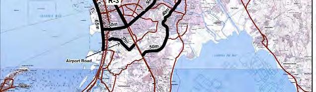
25 FIGURE ROADS WITH ROW MORE THAN 35m
26 La Mesa Parkway : Utilizing MWSS ROW (for water pipes) R-7 Expressway : Utilizing ROW of R-7. Pasig-Marikina Expressway : Utilizing river ROW of Pasig and Marikina Rivers. C-5/FTI/Skyway Connector Road : Utilizing Manila Food Terminal land. Proposed HSH-1 Network under this scenario is shown in Figure All expressways which attract more than 50,000 pcu/day were included in this scenario. As shown in the figure, C- 6 is not connected with radial expressways due to no available space for expressways, thus, C-6 Expressway connection with radial direction was planned to be done by HSH-2. FIGURE HSH-1 DEVELOPMENT SCENARIO-2: METRO MANILA TRAFFIC DECONGESTION SCENARIO 12-25
27 (3) Development Scenario-3: Balanced Development Scenario In order to achieve development policies of 1) promotion of national integration and 2) decongestion of Metro Manila traffic, this development scenario was prepared by combining HSH-1 network of Scenarios-1 and 2. Proposed HSH-1 network is shown in Figure FIGURE HSH-1 DEVELOPMENT SCENARIO-3: BALANCED DEVELOPMENT SCENARIO (SCENARIO-1 + SCENARIO-2) 12-26
28 (4) Development Scenario-4: Do Max Scenario In addition to HSH-1 network under Scenario-3, the following three (3) roads were added; Manila-Bataan Coastal Road: concerned local governments are strongly requesting realization of this road. NLEx-Phase 3: a private sector has a franchise for this route. East-West Connection Expressway: To improve flexibility of selecting routes by road users (NLEx and NLEx-East), this road was proposed. HSH-1 network under this scenario is shown in Figure Table shows HSH projects under each scenario. TABLE HSH-1 PROJECTS FORMING EACH DEVELOPMENT SCENARIO Scenario-1 (Decentralizatio Scenario-2 (Metro Manila Scenario-3 (1+2) Scenario-4 Do Max HSH-1 Project n Scenario) Traffic Decongestion Scenario) Scenario NLEx SLEx Link Expressway NAIA Expressway (Phase 2) - C-6 Expressway/Global City Link C-6 Extension (along Laguna de Bay) - Manila Bay Expressway - CALA Expressway Central Luzon Expressway - Calamba Los Baños Expressway - SLEx Extension (to Lucena City) - NLEx East/La Mesa Parkway - (La Mesa Parkway included) C-5/FTI/Skyway Connector Road - Pasig-Marikina Expressway - R-7 Expressway - Manila-Bataan Coastal Road NLEx-Phase East-West Connection Expressway Note: Project included in a scenario - Project not included in a scenario 12-27
29 FIGURE HSH-1 DEVELOPMENT SCENARIO-4: DO MAX. SCENARIO 12-28
30 Evaluation of Development Scenarios Four (4) HSH-1 development scenarios were evaluated based on the following items; DEVELOPMENT SCENARIOS EVALUATION ITEMS Evaluation Items Evaluation Sub-Items 1. Conformity with National 1.1 Conformity with Decentralization Policy Development Policies 1.2 Conformity with Decongestion of Metro Manila Traffic policy 2. Transport Efficiency 2.1 Travel time performance 2.2 Volume Capacity Ratio (V/C ratio) performance 2.3 Travel Speed Performance 3. Required Investment (total construction cost) 4. Economic Return Single Year B/C Ratio 5. Overall Evaluation Since item 1 cannot be quantitatively evaluated, therefore, qualitative evaluation of each item was made as follows; EVALUATION OF EACH ITEM X Best Achievement or Improvement Medium Achievement or Improvement Low Achievement or Improvement Evaluation results are shown in Table , and summarized as follows; Scenario-1 Does not achieve Decongestion of Metro Manila Traffic policy. Does not reduce traffic problems in Metro Manila. Not recommended. Scenario-2 Does not achieve Decentralization to mitigate overconcentration in Metro Manila policy. Does not reduce traffic problems in outside Metro Manila Area. Not recommended. Scenario-3 Achieve both national policies. Mitigate traffic problems of both inside and outside Metro Manila areas. Can be expected relatively high economic return. Though huge investment is required, investment level is still within DPWH s financial capacity (refer to section of Chapter 16). Recommended
31 Scenario-4 Almost same performance as Scenario-3, except this scenario requires the highest investment, thus economic return is lower than Scenario-3. This scenario includes the following additional three (3) projects to Scenario-3, but these projects can be deferred due to the following reasons; Manila-Bataan Coastal Road There is no major regional urban centers along the corridor, thus it will function as an alternative route of NLEx. When NLEx-East which is more important than this road is formed, some of NLEx traffic will be diverted to NLEx-East, therefore above function of this road will not be so significant, thus this road can be deferred. This road passes through wide flood-prone areas, thus quite costly and roadside development of the areas near interchanges will not be expected. NLEx (Phase III) Major function of this road is to serve traffic between Subic and Metro Manila, of which traffic demand is not so high yet. Above function is being served by the existing SCTEX, thus this road can be deferred. East-West Connection Expressway The function of the expressway is to distribute traffic on NLEx and NLEx-East at a balanced manner. Development of NLEx-East will take a lengthy time, therefore, this expressway can be deferred until such time that NLEx-East is formed. In view of the above evaluation, Scenario-3 was recommended. Characteristics of Development Scenario-3 are as follows; CHARACTERISTICS OF DEVELOPMENT SCENARIOS To conform with national policies of (1) decentralization to mitigate overconcentration in Metro Manila and (2) decongest Metro Manila traffic. All regional urban centers are connected by HSH-1. All international ports and airports are connected by HSH-1 to actively support development of international logistics bases. Sound urban expansion is supported. Accessibility to main tourist spots is improved. Overall travel hours in pcu-hour/day will be reduced to 81% or 1,229 thousand pcu-hours will be saved. Volume capacity Ratio will be improved. Average travel speed will be improved from present 21 km/hr to 27 km/hr. The scenario can be financially affordable by the Government under the assumption of 5% of DPWH budget increase and about 40% private sector financing. High economic return can be expected
32 EVALUATION ITEMS TABLE EVALUATION OF DEVELOPMENT SCENARIO DEVELOPMENT SCENARIO (1)Decentralization (2) Decongestion (3) Balanced (4) Do Max of M.M. Traffic Development Expressway Length 394 km 179 km 443 km 576 km Conformity with National Dev t Policy Transport Efficiency Decentralization Decongest Metro Manila Traffic Travel Time (1,000 pcu.hour per day) V/C Ratio inside Metro Manila V/C Ratio outside Metro Manila X Average Travel Speed (km/hr) Required Investment (Billion Pesos) (1.00) (1.12) (1.61) Economic Return (Single Year B/C Ratio in 2030) Overall Evaluation Does not achieve Decongestion of Metro Manila Traffic policy. Travel time reduced, but not so much. V/C ration in Metro Manila not improved Travel Speed outside Metro Manila improved Requires minimum investment. Highest economic return due mainly to less investment cost than others X X Does not achieve Decentralizatio n policy. Travel time reduced, but not so much V/C ratio in Metro Manila improved. V/C ratio outside Metro Manila not improved. Travel speed inside Metro Manila improved, but same level as Scenario-1 Requires almost same investment as Scenario1 but less than ½ of expressways constructed due to high cost of construction. Medium economic return Conforms to National Policy. Travel time reduced about 20% V/C ratio both inside and outside Metro Manila improved. Travel speed both inside and outside Metro Manila improved. Medium investment among 4 scenarios Medium economic return (2.19) X X 2.20 Conforms to National Policy. Travel time is reduced about 20% V/C ratio both inside and outside Metro Manila improved. Travel speed both inside and outside Metro Manila improved. Requires highest investment. Lowest economic return due mainly to high investment required. X X X Recommendation - - Recommended - Note: Metro Manila includes its suburbs of Cavite, Laguna, Bulacan and Rizal (1) V/C ratio = Volume/Capacity Ratio (2) Evaluation Best achievement, or improvement Medium achievement, or improvement X Low achievement, or improvement 12-31
33 Transport Efficiency TABLE EVALUATION OF TRANSPORT EFFECIENCY OF DEVELOPMENT SCENARIO Present DEVELOPMENT SCENARIO Status (Do Nothing Case) (1) Decentralization Scenario to mitigate overconcentration in Metro Manila (2) Decongestion Metro Manila Traffic Scenario (3) Balanced Development Scenario (Scenario 1+2) (4) Do Max Scenario Travel Time (1,000 pcu.hour per day) V/C Ratio inside Metro Manila V/C Ratio outside Metro Manila Over km (35%) Less km (23%) Over km (0.4%) km (1.3%) Less 1.0 3,623 km (98.3%) 6,475 (1.00) 5,547 (0.86) 774 km 595 km (42%) (30%) 671 km (34%) 703 km (36%) 13 km ( - ) 37 km (1%) 3,767 km (99%) 5,618 (0.87) 565 km (28%) 742 km (37%) 713 km (35%) 15 km ( - ) 49 km (1.3%) 3,623 km (98.3%) X 5,246 (0.81) 542 km (26%) 690 km (33%) 837 km (41%) 12 km ( - ) 35 km (1%) 3,769 km (99%) 5,098 (0.79) 514 km (25%) 674 km (33%) 881 km (42%) 10 km ( - ) 30 km (1%) 3,876 km (99%) Average Travel Speed (km/hr) Inside Metro Manila Outside Metro Manila 18.6 (1.00) 35.2 (1.00) 22.2 (1.19) 42.9 (1.22) 22.8 (1.23) 34.8 (0.99) 23.7 (1.27) 43.0 (1.22) 24.8 (1.33) 43.2 (1.22) Study Area 21.0 (1.00) 25.0 (1.19) 24.7 (1.18) 26.5 (1.26) 27.2 (1.30) Note: Metro Manila includes its suburbs of Cavite, Laguna, Bulacan and Rizal (1) V/C ratio = Volume/Capacity Ratio (2) Evaluation Best achievement, or improvement Medium achievement, or improvement X Low achievement, or improvement 12-32
34 Proposed HSH Network Proposed HSH-1 Network is shown in Figure Among the proposed HSH-1 networks, new projects are listed below: HSH-1 PROJECTS NLEx-SLEx Link Expressway NAIA Expressway (Phase-2) C-6 Expressway / Global City Link C-6 Extension (along Laguna de Bay) Manila Bay Expressway CALA Expressway Central Luzon Expressway (CLEx) Calamba-Los Baños Expressway SLEx Extension (to Lucena City) NLEx East La Mesa Parkway C-5 / FTI / Skyway Connector Road Pasig-Marikina Expressway R-7 Expressway [Beyond 2030] Manila-Bataan Coastal Road NLEx-Phase 3 East-West Connection Expressway 12-33
 PROPOSED HSH-1 AND HSH-2")
35 FIGURE (1/3) PROPOSED HSH-1 AND HSH-2 NETWORK: METRO MANILA 12-34
36 FIGURE (2/3) PROPOSED HSH-1 AND HSH-2 NETWORK: NORTH OF METRO MANILA 12-35
37 FIGURE (3/3) PROPOSED HSH-1 AND HSH-2 NETWORK: SOUTH OF METRO MANILA 12-36
38 Measures to be Taken for HSH-2 Following measures should be taken for HSH-2 roads; North of Metro Manila (1) Manila North Road Along this corridor, TPLEx is under construction and is planned to be extended up to San Fernando, La Union. Improvement of existing sections from Metro Manila to San Fernando, La Union of Manila North Road should be carefully planned to avoid double investment in consideration of TPLEx development, this measures will be limited to the following: - Widening to a 4-lane road within the existing road ROW - Pavement of shoulders for tricycles - Efficient traffic management at intersections (2) Pan Philippine Highway (or Daang Maharlika) Along this corridor, NLEx-East is proposed, however, its development will require lengthy time (maybe about 15 years from today). Before NLEx-East is developed, traffic condition of Pan Philippine Highway will be further aggravated. Cabanatuan Bypass and Gapan Bypass may be required ahead of NLEx-East. These bypasses should be so planned that these can be converted to a part of NLEx-East. Other sections of Pan Philippine Highway are improved in a similar manner adopted for Manila North Road. Metro Manila (1) C-4 (EDSA) (2) C-5 MRT-3 and North Extension of LRT-1 was built at the center of C-4, and most major intersections were grade separated, therefore, a little can be done in terms of facility improvement of this road. Possible facility improvement will be as follows: - Grade separation at EDSA/North Avenue/West Avenue Intersection - Grade separation at EDSA/Congressional Avenue - Widening from MacArthur Highway to R-10 Major intersections were already grade separated, so a little can be done in terms of facility improvement
39 (3) C-3 Along this corridor, Pasig-Marikina Expressway is proposed under this Study. Until the time the proposed expressway is realized, traffic management should be strengthened. Northern section from Rizal Avenue to Baltazar St. still remains at a 2-lane road due to ROW acquisition problem. DPWH should continue to dialogue and negotiate with land owners to acquire ROW. Southern section (south of Aurora Blvd.) is still missing, however, its realization is quite difficult due to ROW acquisition problems. Therefore, improvement of existing section should be focused. Grade separation of the following intersections should be studied; - C-3/E. Rodriquez Avenue Intersection - C-3/Quezon Avenue Intersection (R-7 Expressway is proposed along Quezon Avenue as an elevated structure, therefore, flyover should be planned along C-3) - C-3/A. Bonifacio Avenue Intersection (4) Ortigas Avenue East section (from C-5 towards to the east) is mostly undivided 4 to 6 lanes and too narrow to plan an elevated expressway along this road. Grade separation of an intersection between Ortigas Avenue and Imelda Avenue should be studied. Traffic management measures at a section near a large shopping mall should be studied. (5) Marcos Highway MRT Line-2 Extension is being studied on this road. Road ROW is quite wide, therefore, effective way to utilize wide ROW should be studied. (6) R-10 Many sections are occupied by squatters. Efforts to relocate them should be made and originally planned 6-lane divided road should be realized. (7) Sucat Road Grade separation of the following intersections should be studied; - Sucat Road/President s Avenue - Sucat Road/San Antonio Avenue/Pilipinas Avenue - Sucat Road/Angelina Canaynay Avenue 12-38
40 (8) Alabang-Zapote Road (AZ Road) Grade separation of the following intersections should be studied; - AZ Road/Don Manolo Avenue/Concha Cruz Drive - AZ Road/Marcos Alvarez Avenue - AZ Road/B.F. Resort Avenue - AZ Road/C.V. Starr Avenue (9) Other HSH-2 Roads Facility improvement of other HSH-2 roads in Metro Manila is difficult due to roadside development, therefore, traffic management at intersection, large scale shopping malls, etc., should be intensified. South of Metro Manila (1) Aguinaldo Highway (Cavite Province) CALA Expressway is planned along this corridor, therefore, facility improvement of this road should be carefully planned to avoid double investment. Grade separation of intersection with Coastal Road should be studied. (2) Daang Hari (Cavite Province) This road should be extended from Aguinaldo Highway up to Naic-Tanza Road. (3) Governors Drive (Cavite Province) Some bridges still remain as a 2-lane bridge. These bridges should be widened to 4-lane. (4) Sta. Rosa-Tagaytay Road (Cavite Province) Short sections were developed as a 4-lane road. Widening to a 4-lane road should be continued, where possible within the existing road ROW. (5) Pan Philippine Highway (Daang Maharlika) Along this corridor, SLEx Extension is planned. Improvement of this road should be carefully planned as mentioned for Manila North Road. (6) Laguna de Bay East Flood Control Dike Road Laguna de Bay Lake shore areas were heavily damaged by floods caused by typhoons Ondoy (September 24-25) and Pepeng (October 1-3) in There is a strong need to construct lake shore road to develop the subject areas. Two (2) objectives, i.e. to control flood and to construct a road to serve for traffic along the lake shore and to support land development, are combined and proposed to construct a flood control dike road. The plan is shown in Figure East section should be developed as HSH-2. Various HSH-1 projects are proposed along the west lake shore. It takes time to develop C-6 Extension and Calamba-Los Baños Expressway along the west shore line, therefore, if a dike construction project is urgently 12-39
41 implemented; these expressways can be firstly developed as HSH-2 and then converted to HSH-1 later. (7) Other HSH-2 Roads Necessary improvement should be planned within the existing road ROW, such as widening to a 4-lane road or paving of shoulders. There are several HSH-2 roads accessing to tourism attraction areas. For such road, the following should be implemented; - Beautification of roadsides by planting trees and flowers - Rest areas and view decks should be built at selected spots 12-40


42 FIGURE LAGUNA DE BAY EAST FLOOD CONTROL DIKE ROAD 12-41
43 CHAPTER 13 INITIAL ENVIRONMENTAL EXAMINATION (IEE)
44 CHAPTER 13 INITIAL ENVIRONMENTAL EXAMINATION (IEE) 13.1 ENVIRONMENTAL CONDITIONS Protected Areas From 1992 to the present, 203 Protected Areas (PAs) have been included as initial components of the NIPAS. Of these, 107 have been proclaimed by the President. To date, only 10 have been enacted by Congress and therefore are established under the National Integrated Protected Areas System (NIPAS). None of these are located within the 200 km radius study sphere. The (NIPAS) was enacted into law as Republic Act (R.A.) 7586 in June All areas or islands in the country that has been proclaimed pursuant to a law, presidential decree, presidential proclamation, or executive order as national park, strict nature reserve, watershed, mangrove reserve, fish sanctuary, natural and historical landmark, protected and managed landscape/seascape, as well as identified virgin forests before the effectivity of the Act were designated as initial components of the System A list of Protected Areas found within the 200 km-radius study sphere is presented in Table The location of these are shown in Figs , , and for Region III, IV-A, and NCR, respectively. TABLE LIST OF PROTECTED AREAS FOUND IN THE 200 KM-RADIUS METRO MANILA STUDY SPHERE Name of Protected Area Location Area (Ha) Status Under NIPAS Region III (Central Luzon) 1. Minalungao National Park Gapan and Gen. Tinio, 2, Initial Component Nueva Ecija 2. Biak-na-Bato National Park San Miguel and Doña Initial Component Remedios Trinidad, Bulacan 3. Capas Death March Monument Capas, Tarlac 1.54 Initial Component 4. Mt. Arayat National Park Arayat and Magalang, 3, Initial Component Pampanga 5. Bataan National Park Hermosa, Orani, Samal, 23, Initial Component Abucay, Pila, Balanga, and Morong, Bataan 6. Roosevelt National Park Hermosa and Dinalupihan, 1, Initial Component Bataan 7. Olongapo Naval Base Perimeter Olongapo City, Zambales 9.04 For disestablishment 8. Aurora Memorial Park (Bongabon- Bongabon, Nueva Ecija and 5, Initial Component Baler National Park) Baler, Quezon 9. Lake Malimanga Bird & Fish Candelaria, Zambales Initial Component Sanctuary 10. Mariveles Watershed Forest Mariveles, Bataan Initial Component Reserve 11. Olongapo Watershed Forest Olongapo, Zambales 6, Initial Component Reserve 12. Angat Watershed and Forest Norzagaray, San Jose, Bulacan 6, Initial Component Range and Montalban, Nueva Viscaya 13. Talavera Watershed Reservation Sta. Fe, Nueva Viscaya, Carranglan, Lupao, San Jose, Pantabangan, Nueva Ecija 37, Initial Component 13-1
45 14. Pantabangan-Carranglan Pantabangan, Carranglan, 84, Initial Component Watershed Reservation Nueva Ecija 15. Doña Remedios/General Tinio Doña Remedios, Bulacan, Gen. 20, Initial Component Watershed Tinio Nueva Ecija 16. Calabgan Watershed Forest Casiguran, Aurora 4, Initial Component Reserve 17. Dipaculao Watershed Forest Dipaculao, Aurora 1, Initial Component Reserve 18. Dinadiawan River Protected Dipaculao, Aurora 3, Initial Component Landscape 19. Amro River Protected Landscape Casiguran and Dilasag, Aurora 6, Initial Component 20. Talaytay Protected Landscape Dinalungan, Aurora 3, Initial Component 21. imbahan-talagas Protected Dinalungan, Aurora 2, Initial Component Landscape 22. Dibalo-Pingit-Zabali-Malayat Baler, San Luis, Aurora 4, Initial Component Watershed Forest Reserve 23. Aurora Watershed Forest Reserve Baler, Quezon Initial Component Region IV-A (CALABARZON) 24. Taal Volcano Protected Landscape Provinces of Batangas 4, Initial Component 25. Mts. Palay-Palay-Mataas na Gulod Ternate and Maragondon, 4, Initial Component National Park Cavite and Nasugbu, Batangas 26. Hinulugang Taktak Protected Antipolo, Rizal 0.89 Initial Component Landscape 27. Mts. Banahaw-San Cristobal Majayjay, Laguna, and Lucban, 3, Initial Component Protected Landscape and Tayabas, Quezon 28. Quezon Protected Landscape Atimonan, Padre Burgos and Initial Component Pagbilao, Quezon 29. Unnamed National Park, Wildlife Provinces of Laguna, Quezon, 34, Initial Component Sanctuary and Game Preserve Rizal, and Bulacan 30. Island of Alibijaban Ragay Gulf, Bondoc Peninsula Initial Component in Quezon 31. Pamitinan Protected Landscape Antipolo, Montalban, Rizal 18, Initial Component 32. Mulanay Watershed Forest Mulanay, Quezon Initial Component Reserve 33. Infanta Watershed Forest Reserve Infanta, Quezon Initial Component 34. Polilio Watershed Forest Reserve Polilio, Quezon Initial Component 35. Maulawin Spring Protected Guinayangan, Quezon Initial Component Landscape 36. Buenavista Protected Landscape Mulanay, Quezon Initial Component 37. Lopez Watershed Forest Reserve Lopez, Quezon Initial Component 38. Calauag Watershed Forest Reserve Calauag, Quezon Initial Component 39. Alabat Watershed Forest Reserve Alabat, Quezon Initial Component 40. Tibiang-Damagandong Watershed Quezon, Quezon Initial Component 41. Binahaan River Watershed Forest Reserve Pagbilao, Mauban, Quezon Initial Component 42. Island of Polilio, Alabat, Cabalete, Lamon Bay, Quezon Undetermined Initial Component Jomalig, Patnanongan, Kalotkot, Kalongkooan, Palasan, Calabao, Icol, and San Rafael Mangrove Swamp Forest Reserve National Capital Region (NCR) 43. Quezon Memorial National Park (Ninoy Aquino Parks and Wildlife) Diliman, Quezon City No data Initial Component Source: Planning Section, DENR Protected Areas and Wildlife Bureau 13-2
")
46 13-3 FIGURE PROTECTED AREAS IN REGION III (CENTRAL LUZON) 13-3
")
47 13-4 FIGURE PROTECTED AREAS IN REGION IV-A (CALABARZON) 13-4
")
48 13-5 FIGURE PROTECTED AREAS IN THE NATIONAL CAPITAL REGION (NCR) 13-5
49 Flood Potential Areas Flood potential areas were shown in Figure of Chapter Geohazards As mentioned in Section 7.1 of Chapter 7, existing geological, geomorphic and tectonic conditions of the 200 km radius Metro Manila study sphere pose certain geological hazards that will affect future infrastructure projects. These include (i) ground shaking, (ii) ground rupture, and (iii) liquefaction. These hazards are due to the presence of earthquake generators near the area. A brief description of these geohazards is presented below. Ground shaking are strong ground vibrations caused by the passage of seismic waves from the earthquake source (foci) to the ground surface. The intensity of ground shaking in a given area is influenced by the magnitude of the earthquake, distance of the site from earthquake generator, and the modifying effects of subsoil conditions. Normally the shallower the earthquake source and the closer the area from the epicenter, the stronger is the intensity felt within the particular site. Previous works showed probable level of ground shaking on a regional context, where the intensity of the ground shaking is usually translated into percentage of the ground acceleration (g). Hazard maps are prepared to take into consideration the contribution of all possible earthquake generators within a broad area for certain span of time (e.g. 100-year return period) and the result expressed in probabilities (e.g. 90% of non-exceedence). Ground rupture is the surface rupturing or the breaking and movements of the ground along an active fault trace, which could result to horizontal/vertical shifting of the ground or a combination of both. For structures directly straddling and located within a narrow zone of the active fault traces, damages can be severe. For example during the July 16, 1990 earthquake, deformation zones ranged from 5-10 meters from the surface rupture. Accurate delineation of these traces is very important in mitigating the damages due to surface rupturing since the location, pattern, and style of surface faulting generally appear to occur along pre-existing active fault traces. Liquefaction is a phenomenon in which a soil deposit below the groundwater table becomes fluid-like and loses a substantial amount of strength due to strong earthquake ground shaking. Some soil types tend to compact during earthquake shaking. When this occurs, compaction will induce excess pore water pressures in the soil and as a result reduces the strength of the soil. The fluid-like condition of liquefied soil may continue for some period of time following the earthquake, until the excess pore water pressure dissipates, depending on soil permeability and drainage conditions. Potential consequence of liquefaction includes (Dayanghirang, 1999): (i) (ii) (iii) (iv) (v) (vi) Reduction or loss of foundation-bearing strength that can lead to large settlements due to shear failure in the weakened soil; Flotation of the lightweight structures embedded in the liquefied soils; Differential compaction due to soil densification as excess pore water pressures dissipate, which can lead to differential settlements in the structure foundation Lateral movements due to lateral spreading or flow sliding of liquefied soils that can lead to total and differential movements of the structure; Increase lateral pressure on the retaining walls; Settlement hazards due to sand boils which involves ejection of liquefied soils to ground surface through vents; and 13-6
50 (vii) Ground oscillation where ground overlying liquefied soil experiences large displacement transient oscillations resulting to fissures, buckling and thrusting of structures. Manifestations of the active geologic and tectonic settings in the study sphere can be described in terms of events that took place in the past. In the CALABARZON area, there are two large earthquakes reported which identified Quezon as the epicenter. The first is the Alabat Earthquake in 1937 and the Ragay Gulf Earthquake in The Ragay Gulf Earthquake damaged properties, transportation and communication lines in Calauag and Lopez in Quezon while the Alabat Earthquake destroyed buildings in greater Manila area, Laguna and Batangas. Add to these the two active volcanoes, Taal and Mount Banahaw which may also pose threat especially in their immediate vicinities. In July 16, 1990 a great Ms 7.8 earthquake hit Luzon. This earthquake was caused by movement of the Digdig Fault in the vicinity of Cabanatuan. It killed 1,700 people, injured 3,000 individuals and displaced 148,000 more in Luzon. Among the cities that sustained the worst damages were Baguio, Dagupan and Cabanatuan. In the following year, Mt. Pinatubo, located at the intersection of the borders of the provinces of Zambales, Tarlac, and Pampanga, erupted and produced the second largest terrestrial eruption of the 20th century. As a consequence, surrounding areas were severely damaged by pyroclastic flows, ash deposits, and later by lahars caused by rainwater remobilizing earlier volcanic deposits. Thousands of houses and other important infrastructures such as roads and bridges were also destroyed. In August 2002, the JICA-Assisted Study for Earthquake Impact Reduction for Metropolitan Manila in the Republic of the Philippines (MMEIRS) was commenced. The main objective of the study is to prepare an earthquake disaster mitigation plan that will enable concerned government agencies, such as the Metropolitan Manila Development Authority (MMDA) and the Philippine Institute of Volcanology and Seismology (PHIVOLCS) to manage potential earthquake disasters in Metropolitan Manila. According to the Study, the possible seismic sources that may cause much damage to Metro Manila in the future are the: (i) Valley Fault System (VFS) and (ii) Laguna-Banahaw Fault and Digdig and Infanta Segments of the Philippine Fault Zone (PFZ). However the Valley Fault System, is considered to potentially cause the largest impact should it generate a large maximum earthquake. As indicated in recent studies, the West Valley Fault has moved four (4) times and generated strong earthquakes within the last 1400 years. Since the approximate return period of these earthquakes is less than 500 years and no event along the West Valley Fault is known after the 17th century, this indicates that the active phases of the Valley Faults may be approaching. Liquefaction Potential As previously described, Metropolitan Manila is divided morphologically into three major parts, namely the: (i) Central Plateau, (ii) Coastal Lowland and (iii) Marikina Valley. In Coastal Lowland and Marikina Plain, Quaternary deposits with loose sands are distributed near ground surface. For large earthquake motions, liquefaction potential of loose sands is high. Structures are expected to be damaged since liquefaction will cause ground deformation such as subsidence and lateral flow. As shown in Table , the area ratio of Coastal Lowland and Marikina Plain relative to the entire Metro Manila area is 34%. In the Cities of Manila, and Pasig lowland area ratio is more than 80%. Pateros, being almost 100% quaternary is substantially vulnerable to liquefaction. 13-7
51 Based on the liquefaction analysis done in the MMEIRS Study, strong movements along the West Valley Fault system, show the highest potential of liquefaction among the following areas: (i) in the City of Manila, around the mouth of Pasig River; (ii) area from center of Pasig City to Pateros and Taguig, and (iii) parts of Malabon City, Parañaque City, and Marikina City. It is important to note however, that high potentials for liquefaction for certain areas do not mean that the entire area will be liquefied during a strong earthquake; it s just a strong indication that liquefaction can be observed in many places compared to those with low potential. In the same manner, areas with low potential does not mean that the entire area will be safe. The important thing is to ensure that a thorough evaluation of areas with liquefaction potential must be made, particularly for the stability of foundations of important structures. TABLE DISTRIBUTION OF QUATERNARY DEPOSITS IN METRO MANILA City/Municipality Area (Ha) Quaternary Deposits Area Ratio (%) Area (Ha) Quezon 165,330 10,669 6 Las Piñas 32,265 2,487 8 San Juan 5, Kalookan 53,116 8, Mandaluyong 11,069 2, Makati 31,961 8, Parañaque 45,606 11, Navotas 10,948 3, Muntinlupa 38,129 10, Valenzuela 44,518 17, Marikina 22,646 13, Taguig 27,521 17, Pasay 17,779 12, Malabon 15,962 12, Pasig 31,883 26, Manila 41,284 40, Pateros 1,951 1, TOTAL 597, , Source: PHIVOLCS, MMDA. Study for Earthquake Impact Reduction for Metropolitan Manila in the Republic of the Philippines 13.2 SCOPING OF PROPOSED PROJECTS According to DENR Guideline, categorization of project based on the overall rating is as follows; Category A: Environmentally Critical Projects (ECP) Major roads with length greater than or equal to 20 km for flat terrain and greater than or equal to 10 km for areas with critical slopes. Will require preparation of EIS to merit ECC Category B: Non-Environmentally Critical Project (NECP) in Environmentally Critical Area (ECA) Minor roads greater than 2 km but less than 20 km for flat terrain or greater than 2 km but less than 10 km for areas with critical slopes. Will require preparation of IEER to merit issuance of ECC Category C: Same as Category B but will prepare IEEC if road is greater than 2 km but less than 10 km for flat terrain or greater than 2 km but less than 5 km for areas with critical slopes 13-8
52 Category D: Project does not fall within Phil. IES System and will require preparation of Project Description (now in form of a checklist) to merit CNC For projects with >200 affected persons: WB, ADB, and JICA classify it as Category A. DENR still follows their project grouping but after scoping, they can reclassify from B to A. Under this Study, when 200 or more persons are expected to be affected, the project was classified as Category A. The EIA category, report type, decision document, and deciding authority for each proposed project are provided in Table Scoping matrices for the 18 priority projects are presented in Annex TABLE EIA CATEGORY, REPORT TYPE, DECISION DOCUMENT, AND APPROVING AUTHORITY FOR PRIORITY PROJECTS UNDER THE HSH Priority Project Category Report Decision Approving Type Document Authority 1. NLEx-SLEx Link Expressway A EIS ECC DENR Secretary 2. NAIA Expressway-2 A EIS ECC DENR Secretary 3. C6 Expressway A EIS ECC DENR Secretary 4. C6 Extension A EIS ECC DENR Secretary 5. Manila Bay Expressway A EIS ECC DENR Secretary 6. CALA Expressway A EIS ECC DENR Secretary 7. Central Luzon Expressway A EIS ECC DENR Secretary 8. Calamba-Los Baños Expressway A EIS ECC DENR Secretary 9. SLEx Extension (To Lucena) A EIS ECC DENR Secretary 10. NLEx East A EIS ECC DENR Secretary 11. La Mesa Parkway A EIS ECC DENR Secretary 12. C5/FTI/Skyway Connector Road A EIS ECC DENR Secretary 13. Pasig-Marikina Expressway A EIS ECC DENR Secretary 14. R-7 Expressway A EIS ECC DENR Secretary 15. Manila-Bataan Coastal Road A EIS ECC DENR Secretary 16. NLEx Phase 3 A EIS ECC DENR Secretary 17. East-West Connection Expressway A EIS ECC DENR Secretary As shown above, all projects were evaluated to be Category A. From the stage of project planning to the detailed design and construction stage, all possible ways to mitigate adverse environmental and social impacts must be planned and incorporated in the project cost. During the feasibility study stage, detailed Environmental Impact Assessment (EIA) Study must be undertaken. Suggested TOR for EIA Study is presented in Annex
53 CHAPTER 14 PRELIMINARY DESIGN AND PROJECT COST ESTIMATE
54 CHAPTER 14 PRELIMINARY DESIGN AND PROJECT COST ESTIMATE 14.1 OUTLINE OF PROPOSED HSH-1 PROJECTS Outline of proposed 18 projects is described hereunder NLEx-SLEx Link Expressway (1) Objectives of the Project To complete the north-south industrial development beltway transport axis by connecting NLEx with SLEx. To decongest Metro Manila traffic. To provide better access to Manila ports. (2) Proposed Alignment In close relation to this project, the following projects are committed by a private sector; NLEx Segment 9 which is from NLEx to McArthur Highway along C-5 alignment. NLEx Segment 10 (1) which is from McArthur Highway to C-3 along PNR Line (PNR ROW is utilized.) NLEx Segment 10 (2) which is C-3 section from PNR to R-10. According to the plan of a private sector, NLEx Segment 10 (2) is just an improvement of C-3 section. NLEx Segment 10 (2) is an important section to provide better and direct access to Manila North Harbor from the NLEx-SLEx link, therefore, it is proposed that new road facility for this section should be provided together with NLEx-SLEx link. (a) Alternative Alignments There are 4 alternative alignments for this project as follows: Alternative Alignments Alternative-1 : PNR Alignment Alternative-2 : Skyway III Alignment Alternative-3 : C-2 Alignment Alternative-4 : Combination of Alternatives 1 &
55 There are two cases to consider alignments, as follows; Case-1 : All alternative alignments are connected to NLEx Segment 10.1 and start at C-3/PNR intersecting point and end at Skyway Phase I (see Figure ). Case-2 : Alternative-1 starts at the same point as Case-1. All other alternatives start at the section between NLEx Toll Plaza and EDSA (see Figure ). All alternatives have structurally difficult sections due to existing 2 nd or 3 rd level structures such as existing viaduct, MRT/LRT structure, etc., as shown in Annex All alternatives need ROW acquisition and resettlement of PAPs as shown in Figure Preliminary design, traffic assignments, cost estimates were undertaken for all alternatives, and they were evaluated their superiority over to the other to select optimum alignment. 14-2

56 14-3 FIGURE NLEx-SLEx LINK EXPRESSWAY ALTERNATIVES: CASE-1 FIGURE NLEx-SLEx LINK EXPRESSWAY ALTERNATIVES: CASE

57 FIGURE AFFECTED BUILDINGS AND REQUIRED LAND ACQUISITION 14-4
58 (b) Evaluation Criteria of Alternative Alignments With due discussion with TWG, evaluation criteria of alternative alignments was established as shown in Table TABLE EVALUATION CRITERIA OF ALTERNATIVE ALIGNMENTS Evaluation Item Weight Evaluation Sub-item Sub-weight (A) Transport Efficiency: Year Expressway Traffic: No. of vehicles attracted by Expressway (pcu/day) Over 1000,000 90, ,000 60,000 90,000 Less 60, (5.0) (4.0) (3.0) (2.0) (B) Initial Investment Requirement (C) Social/Environmental Impact (D) Construction Difficulty 5 (E) Economic & Financial Viability Reduction of Travel Time: All network Over 50,000 25,000 50,000 10,000 25,000 Less 10,000 Reduction of At-grade Road Traffic Volume at Screen Line (veh/day) Over 20,000 10,000 20,000 5,000 10,000 Less 5,000 Construction Cost Least Cost times of least cost times of least cost times of least cost Over 1.3 times of least cost ROW Acquisition/Compensation Cost Least Cost times of least cost times of least cost Over 1.2 times of least cost Land Area to be Acquired Least area times of least area times of least area Over 1.5 times of least area No. of Structure Affected Least No times of least no times of least no. Over 1.5 times of least no. No. of Floor Area Affected Least area times of least area times of least area Over 1.5 times of least area Construction Difficulty Relatively easy Difficult Traffic Management During Construction Relatively easy Difficult EIRR (%) Over 25% 20 25% 15 20% Less 15% FIRR (%) Over 15% 10 15% 5 10% Less 5% 15 (15.0) (12.5) (10.0) (5.0) 5 (5.0) (4.0) (3.0) (2.0) 20 (20.0) (15.0) (10.0) (5.0) (1.0) 10 (10.0) (8.0) (5.0) (1.0) 5 (5.0) (4.0) (3.0) (1.0) 5 (5.0) (4.0) (3.0) (1.0) 5 (5.0) (4.0) (3.0) (1.0) 2.5 (2.5) (0.5) 2.5 (2.5) (0.5) 15 (15.0) (12.5) (10.0) (5.0) 10 (10.0) (8.0) (6.0) (4.0) Total
 was evaluated as the most optimum alignment for both cases. It is recommended to adopt PNR Alignment for this project. (3) Outline of the Project Expressway Length : 13.")
59 (c) Evaluation of Alternative Alignment Alternative alignments were evaluated based on the evaluation criteria, as shown in Table Alternative-1 (PNR Alignment) was evaluated as the most optimum alignment for both cases. It is recommended to adopt PNR Alignment for this project. (3) Outline of the Project Expressway Length : km. Beginning : Intersecting point of PNR and C-3 (end of NLEx Segment 10) End : Skyway III Type of Structure : All elevated structure No. of lanes : 2 x 2 = 4-lane Proposed Alignment : Utilizes PNR ROW, Quirino Avenue ROW and Pres. Sergio Osmeña Highway FIGURE NLEx-SLEx LINK EXPRESSWAY 14-6
60 Outline of Alternative (A) Transport Efficiency (Year 2015) TABLE (1/2) EVALUATION OF ALTERNATIVE ALIGNMENTS: CASE-1 (B) Initial Investment Requirement (C) Social/ Environmental Impacts (D) Construction Difficulty (E) Economic and Financial Aspects Alternative - 1 Alternative - 2 Alternative - 3 Alternative 4 Concept PNR Route C-3 Route (Skyway-Phase 3) C-2 Route Combination of Alternative 1 & 3 Route Length (km) N-S Link : N-S Link : N-S Link : N-S Link : Port Access: 2.40 Port Access : 2.40 Port Access : 2.40 Port Access : 2.40 Total : Total : Total : Total : ROW to be used. PNR 65% Road 35% Expressw ay All Road Network No. of Vehicles attracted per day Reduction of At-grade Road Traffic Volume at Screen Line (veh/day) (1) Construction Cost (Billion Pesos) (2) ROW Acquisition and Compensation Cost (Billion Pesos) (1) + (2) Land Area to be Acquired (sq.m.) No. of Structure Affected (Note 1) No. of Floor Area Affected (sq. m.) Constructability Traffic Management during Construction Economic Features Financial Aspects 90,400 (1.00) (+1.75 km) PNR 14% Road 86% 94,200 (1.04) (-0.35 km) PNR 4% Road 96% 103,900 (1.15) (+0.75 km) PNR 35% Road 65% 84,700 (0.94) Reduction of Travel Time -68,000 (1.00) -66,000 (0.97) -68,000 (1.00) -64,000 (0.94) (pcuhour/day) Average Travel Speed 25.2 (w/o 24.7) (km/hour) EIRR (%) Revenue per Day (Million Php) FIRR (%) -21,600 (1.00) N-S Link : Port Access: 2.96 Total : (1.00) N-S Link : 1.00 Port Access: - Total : 1.00 (1.00) (1.00) 15,300 (1.00) 403 ((263)) (1.92) 44,400 (1.00) Construction space limited along rail. One side construction, then shift to other side. Equipment and material transportation along the rail. One-track operation along rail. (F) Other Features Possibility of future PNR grade separation needs to be considered. Total Score Ranking -21,200 (0.98) -13,300 (0.62) -20,300 (0.94) N-S Link : Port Access : 2.96 Total : (1.11) N-S Link : Port Access : 2.96 Total : (1.07) N-S Link : Port Access : 2.96 Total : (1.12) 20.0 (+3.68 BP) 10.0 (+2.20 BP) 15.0 (+3.85 BP) 10.0 N-S Link : 1.15 Port Access : - Total : 1.15 (1.15) N-S Link : 1.48 Port Access : - Total : 1.48 (1.48) N-S Link : 1.06 Port Access : - Total : 1.06 (1.06) 10.0 (+0.15 BP) 5.0 (+0.48 BP) 1.0 (+0.06 BP) (1.12) (1.08) (1.12) - (+3.83 BP) - (+2.68 BP) - (+3.91 BP) - 25,000 (1.63) 32,000 (2.09) 18,700 (1.22) (1.00) 273 (1.30) 353 ((287)) 1.68) ,400 (1.09) 64,200 (1.45) 49,700 (1.12) Construction along heavy traffic road. Night work. Construction along heavy traffic road. Night work. Construction along heavy traffic road. Night work Careful traffic management needed Careful traffic management needed Careful traffic management needed % 16.1% 16.4% 15.0% (1.00) (1.06) (1.07) 9.02 (0.91) % 8.7% 9.2% 7.8% Possibility of future PNR grade separation needs to be considered. Affects viability of Segments 9&10. Note-1: (( )) No. of structures when PNR continues to relocate those within PNR ROW. Possibility of future PNR grade separation needs to be considered. Affects viability of Segments 9& Possibility of future PNR grade separation needs to be considered. Affects viability of Segments 9&
61 Outline of Alternative (G) Transport Efficiency (Year 2015) (H) Initial Investment Requirement TABLE (2/2) EVALUATION OF ALTERNATIVE ALIGNMENTS: CASE-2 Alternative - 1 Alternative - 2 Alternative - 3 Alternative 4 Concept PNR Route C-3 Route (Skyway-Phase 3) Route Length (km) N-S Link : N-S Link : Port Access: 2.40 Port Access : 4.30 Total : Total : ROW to be used. PNR 65% Road 35% Expressway No. of Vehicles 90,400 attracted per (1.00) day All Road Network Reduction of Travel Time (pcuhour/day) Average Travel Speed (km/hour) Reduction of At-grade Road Traffic Volume at Screen Line (veh/day) (1) Construction Cost (Billion Pesos) (2) ROW Acquisition and Compensation Cost (Billion Pesos) -68,000 (1.00) 25.2 (w/o 24.7) -21,600 (1.00) N-S Link : Port Access: 2.96 Total : (1.00) N-S Link : 1.00 Port Access: - Total : 1.00 (1.08) (+4.65 km) PNR 12% Road 88% 105,900 (1.17) C-2 Route Combination of Alternative 1 & 3 N-S Link : N-S Link : Port Access : 4.30 Port Access : 4.30 Total : Total : (+2.90 km) (+4.05 km) PNR 3% Road 97% 108,500 (1.20) PNR 29% Road 71% 104,000 (1.15) ,000 (1.32) -93,000 (1.37) -88,000 (1.29) ,900 (1.06) -21,100 (0.98) -23,800 (1.10) N-S Link : Port Access : 7.72 Total : (1.27) N-S Link : Port Access : 7.72 Total : (1.25) N-S Link : Port Access : 7.72 Total : (1.30) 20.0 (+8.71 BP) 5.0 (+7.99 BP) 5.0 (+9.57 BP) 1.0 N-S Link : 1.35 Port Access : - Total : 1.35 (1.45) N-S Link : 1.35 Port Access : - Total : 1.35 (1.45) N-S Link : 0.93 Port Access : - Total : 0.93 (1.0) (1) + (2) (1.00) 8.0 (+0.35 BP) 1.0 (+0.35 BP) 1.0 (-0.07 BP) (1.27) (1.25) (1.29) (I) Social/ Environmental Impacts (J) Construction Difficulty Land Area to be Acquired (sq.m.) No. of Structure Affected (Note-1) No. of Floor Area Affected (sq. m.) Constructability 15,300 (1.00) 403 ((263)) (2.20) 44,400 (1.02) Construction space limited along rail. One side construction, then shift to other side. Equipment and material transportation along the rail. - (+9.06 BP) - (+8.34 BP) - (+9.50 BP) - 31,700 (2.07) 28,600 (1.87) 15,300 (1.00) (1.0) 217 (1.09) 297 ((231)) (1.62) ,600 (1.28) 57,900 (1.33) 43,400 (1.0) Construction along heavy traffic road. Night work. Construction along heavy traffic road. Night work. Construction along heavy traffic road. Night work. (K) Economic and Financial Aspects Traffic Management during Construction Economic Features Financial Aspects EIRR (%) Revenue per Day (Million Php) FIRR (%) One-track operation along Careful traffic Careful traffic Careful traffic rail. management needed management needed management needed % 24.0% 25.0% 23.6% 9.92 (1.00) (L) Other Features Possibility of future PNR grade separation needs to be considered (1.23) (1.21) (1.16) % 10.7% 10.2% 9.6% Possibility of future Possibility of future Possibility of PNR grade separation PNR grade future PNR grade needs to be separation needs to separation needs considered. be considered. to be considered. Affects viability of Affects viability of Affects viability Segments 9&10. Segments 9&10. of Segments Total Score & Ranking Note-1: (( )) No. of structures when PNR continues to relocate those within PNR ROW. 14-8
 Proposed Alignment Proposed alignment is shown in Figure 14.1.2-1.")
62 NAIA Expressway: Phase 2 (1) Objectives of the Project To provide access to three (3) NAIA terminals. To connect Skyway with Manila-Cavite Coastal Expressway so as to improve route selection flexibility of road users. (2) Proposed Alignment Proposed alignment is shown in Figure (3) Outline of the Project Expressway Length : 4.9 km. Beginning : End of Phase I End : Roxas Boulevard Type of Structure : All elevated structure No. of lanes : 2 x 2 = 4-lane Proposed Alignment : Utilize ROW of Andrews Avenue, Parañaque River, and NAIA Road FIGURE PROPOSED NAIA EXPRESSWAY PHASE-2 ALIGNMENT 14-9
 Proposed Alignment Proposed alignment is shown in Figure 14.1.3-1.")
63 C-6 Expressway (1) Objectives of the Project To form a backbone urban transport axis. To distribute traffic from expressways in the radial directions. To guide sound urbanization and support land development of the eastern Metro Manila area and Rizal Province. (2) Proposed Alignment Proposed alignment is shown in Figure (3) Outline of the Project Expressway Length : 64.8 km. Beginning : NLEx between Marilao and Bocaue End : Skyway at Bicutan Type of Structure : Cut/Embankment - 91% (59.0 km.) Viaduct/Bridges - 9% ( 5.8 km.) No. of lanes : 2 x 2 = 4-lane (to be expanded to 2 x 3 = 6-lane) FIGURE PROPOSED ALIGNMENT OF C-6 EXPRESSWAY 14-10
 Proposed Alignment Proposed alignment is shown in Figure 14.1.4-1.")

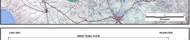
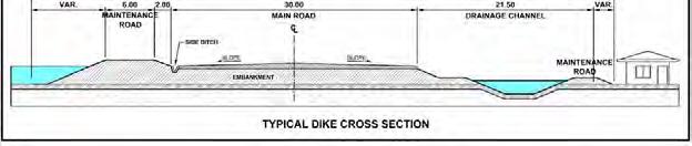
64 C-6 Extension ( Laguna de Bay Flood Control Dike Expressway) (1) Objectives To decongest traffic on Manila South Road and SLEx. To contribute to flood control along Laguna de Bay Coastal area and land development. (2) Proposed Alignment Proposed alignment is shown in Figure Typical cross section is shown in Figure (3) Outline of the Project Expressway Length : 43.6 km. Beginning : Divert from C-6 at Taguig City End : To be connected with CALA Expressway and Calamba- Los Baños Expressway Type of Structure : Embankment No. of lanes : 2 x 2 = 4-lane FIGURE PROPOSED ALIGNMENT OF C-6 EXTENSION/ LDB FLOOD CONTROL DIKE EXPRESSWAY Laguna de Bay FIGURE TYPICAL CROSS SECTION 14-11
 Proposed Alignment Proposed alignment is shown in Figure 14.1.5-1. Immersed tunnel is proposed for the section under the sea.")

65 Manila Bay Expressway (1) Objectives of the Project To decongest Metro Manila traffic, particularly Roxas Boulevard. To provide access to Manila ports. (2) Proposed Alignment Proposed alignment is shown in Figure Immersed tunnel is proposed for the section under the sea. Other section is proposed to be U-type tunnel. (3) Outline of the Project Expressway Length : 8.0 km. Beginning : Manila-Cavite Coastal Expressway End : Bonifacio Drive Type of Structure : - U-type tunnel - Immersed tunnel No. of lanes : 2 x 2 = 4-lane F I G URE PROPOSED ALIGNMENT OF MANILA BAY EXPRESSWAY FIGURE TYPICAL CROSS SECTION OF IMMERSED TUNNEL 14-12
 Proposed Alignment Proposed alignment is shown in Figure 14.1.6-1. (3) Outline of the Project Expressway Length : 63.9 km.")
66 CALA Expressway (1) Objectives of the Project To decongest Cavite roads traffic, particularly Aguinaldo Highway and Governor s Drive. To provide access to economic zones to support economic development. (2) Proposed Alignment Proposed alignment is shown in Figure (3) Outline of the Project Expressway Length : 63.9 km. Beginning : End of Manila-Cavite Coastal Road Extension End : Near Greenfield I/C of SLEx Type of Structure : Cut/fill No. of lanes : 2 x 3 = 6-lane FIGURE PROPOSED ALIGNMENT OF CALA EXPRESSWAY 14-13
 Proposed Alignment Proposed alignment is shown in Figure 14.1.7-1.")
67 Central Luzon Expressway (1) Objectives of the Project To connect SCTEx and NLEx-East to efficiently distribute traffic to both expressways. To decongest traffic on the Pan Philippine Highway until such time that NLEx-East becomes operational. (2) Proposed Alignment Proposed alignment is shown in Figure (3) Outline of the Project Expressway Length : 63.9 km. Beginning : Tarlac Interchage of SCTEx End : North of San Jose City, Pan Philippine Highway Type of Structure : Cut/Fill No. of lanes : 2 x 2 = 4-lane FIGURE PROPOSED ALIGNMENT OF CENTRAL LUZON EXPRESSWAY 14-14
 Proposed Alignment There are two alternative alignments as shown in Figure 14.1.8-1.")
68 Calamba-Los Baños Expressway (1) Objectives of the Project To decongest traffic of national roads. To support tourism industry along the corridor. To contribute to flood control when Laguna de Bay side alignment is selected. (2) Proposed Alignment There are two alternative alignments as shown in Figure Laguna de Bay side alignment is preferably selected to contribute to flood control. (3) Outline of the Project Expressway Length : 15.5 km. Beginning : SLEx between Calamba and San Rafael End : Between Los Baños and Bay Type of Structure : Cut/Fill and/or combined structure of flood control dike and road No. of lanes : 2 x 2 = 4-lane FIGURE CALAMBA-LOS BAÑOS TOLL EXPRESSWAY 14-15
Roadmap for Transport Infrastructure Development for Metro Manila and Its Surrounding Areas (Region III and Region IV-A) Main Points of the Roadmap
 Main Points of the Roadmap") Roadmap for Transport Infrastructure Development for Metro Manila and Its Surrounding Areas (Region III and Region IV-A) Main Points of the Roadmap Technical Assistance from the Japan International Cooperation
Roadmap for Transport Infrastructure Development for Metro Manila and Its Surrounding Areas (Region III and Region IV-A) Main Points of the Roadmap Technical Assistance from the Japan International Cooperation
PANEL 2: COMPETITIVE RAIL AND HIGHWAY NETWORKS
 SEVENTH ARANGKADA PHILIPPINES ANNIVERSARY FORUM ARANGKADA PHILIPPINES: BETTER INFRASTRUCTURE FOR A STRONG ECONOMY September 12, 2018 Marriott Grand Ballroom, Marriott Hotel Manila PANEL 2: COMPETITIVE
The Highlights of the Comprehensive Land Use Plan are as follows:
 Executive Summary Comprehensive Land Use Plan of the City of San Fernando, Pampanga 2012-2021 Section 20 of the Local Government Code of 1991 mandates Local Government Units (LGUs) to prepare a Comprehensive
Makati City. Attention: Re : Gentlemen: Thank. Very truly yours, 1 March Officer
 1 March 2012 DISCLOSURE DEPARTMENT The Philippine Stock Exchange Philippine Stock Exchange Plaza Ayala Triangle, Ayala Avenue Makati City Attention: Re : MS. JANET A. ENCARNACION PGOLD Analysts Briefing
NORTH-SOUTH CORRIDOR STUDY EXECUTIVE SUMMARY. Executive Summary
 Executive Summary Background As congestion continues to affect mobility in the region, the Ozarks Transportation Organization (OTO) is particularly concerned with traffic movement. The North-South Corridor
DOWNTOWN JACKSONVILLE MASTER PLAN S T R E E T H I E R A R C H Y
 DOWNTOWN JACKSONVILLE MASTER PLAN S T R E E T H I E R A R C H Y Gateway Intra-District Business Inter-District 44 CELEBRATING THE RIVER: A PLAN FOR DOWNTOWN JACKSONVILLE The Transportation Network This
PREPARED FOR: PLATTEVIEW ROAD CORRIDOR STUDY EXECUTIVE SUMMARY
 PREPARED FOR: PLATTEVIEW ROAD CORRIDOR STUDY EXECUTIVE SUMMARY SEPTEMBER 2016 Introduction The Platteview Road Corridor Study was led by the Metropolitan Area Planning Agency (MAPA) with assistance from
PEOPLE S COMMITTEE OF HO CHI MINH CITY DEVELOPMENT STRATEGY FOR HO CHI MINH CITY S INFRASTRUCTURE
 PEOPLE S COMMITTEE OF HO CHI MINH CITY DEVELOPMENT STRATEGY FOR HO CHI MINH CITY S INFRASTRUCTURE Singapore, July 2012 1 GENERAL INFORMATION 2 GENERAL INFORMATION The centre for economics, culture, science
Shift Rapid Transit Public Participation Meeting May 3, 2017
 Shift Rapid Transit Public Participation Meeting May 3, 2017 Shift Rapid Transit Initiative Largest infrastructure project in the city s history. Rapid Transit initiative will transform London s public
SCARBOROUGH RAPID TRANSIT ENVIRONMENTAL PROJECT REPORT CHAPTER 2 PROJECT DESCRIPTION. Table 2-4: North Segment Alignment Analysis 2-21
 Table 2-4: North Segment Alignment Analysis 2-21 SCARBOROUGH RAPID TRANSIT Based on the above analysis (detailed analysis is contained in Appendix A-4), North Alignment 3 is preferred because it: Has the
Social Screening and Impact Assessment for Sub Projects
 Social Screening and Impact Assessment for Sub Projects Code No: 7 A. Sub Project Description: Rehabilitation of McCallum Lock Gates and Construction of Bank Protection Wall with Linear Walk Around Beira
Figure 5. Previously Identified Viable Corridors
 OVERVIEW The Central Florida Expressway Authority (CFX) is evaluating the potential to expand SR 408 from its current eastern terminus along SR 50 to SR 520 in northeastern Orange County, Fl. This new
Heritage Road Improvements from Steeles Avenue to Rivermont Road
 The Corporation of the City of Brampton Heritage Road Improvements from Steeles Avenue to Rivermont Road Class Environmental Assessment Study (Schedule C) September 19, 2013 The Corporation of the City
COSCO CAPITAL GROUP INVESTOR PRESENTATION FY 2015 RESULTS & PERFORMANCE
 COSCO CAPITAL GROUP INVESTOR PRESENTATION FY 2015 RESULTS & PERFORMANCE 1 DISCLAIMER These presentations and/or other documents have been written and presented by COSCO CAPITAL, INC. (COSCO). COSCO is
Public Information Centre #1
 and Highway 401 Interchange Improvements WELCOME Public Information Centre #1 Veterans Memorial Parkway Extension and Highway 401 Interchange Improvements Study May 23, 2012 4 p.m. to 7 p.m. Brief Overview
PUREGOLD PRICE CLUB, INC.
 Sa PUREGOLD PRICE CLUB, INC., Always Panalo! Company Presentation 1Q 2016 Results and Performance July 2016 Disclaimer These presentations and/or other documents have been written and presented by Puregold
YONGE STEELES CORRIDOR SECONDARY PLAN. Young + Wright / IBI Group Architects Dillon Consulting Ltd. GHK International (Canada) Ltd.
 Ltd.") PART A: PREAMBLE 1.0 PURPOSE The purpose of this Secondary Plan is to provide a development framework for intensification of the Yonge/ Steeles corridor including the north side of Steeles Avenue West
PART A: PREAMBLE 1.0 PURPOSE The purpose of this Secondary Plan is to provide a development framework for intensification of the Yonge/ Steeles corridor including the north side of Steeles Avenue West
TRANSPORTATION ELEMENT GOALS, OBJECTIVES, AND POLICIES
 TRANSPORTATION ELEMENT GOALS, OBJECTIVES, AND POLICIES GOAL 2 The City shall provide a safe, convenient, effective, and energy efficient multimodal transportation system which is coordinated with the Future
TOWN OF WHITBY REPORT RECOMMENDATION REPORT
 TOWN OF WHITBY REPORT RECOMMENDATION REPORT REPORT TO: Council REPORT NO: PL 95-09 DATE OF MEETING: October 13, 2009 PREPARED BY: Planning/Public Works Joint Report FILE NO(S): N/A LOCATION: N/A REPORT
6 Sub-Sector Strategies
 6 Sub-Sector Strategies 6.1 In accordance with the proposed goals and objectives for the Study Area until 2027, the sub-sector strategies have been itemized for fulfilling the requirements of the proposed
«Corridor» designs in town planning : Sustainable planning for large cities in developed countries
 CODATU XIII «Corridor» designs in town planning : Sustainable planning for large cities in developed countries Challenges of implementation in booming cities in emerging and developing countries Lyon Town
Roosevelt Corridor. R e i n v e s t m e n t P l a n. Public Meeting Gilbert Elementary School May 12, :00 pm
 Roosevelt Corridor R e i n v e s t m e n t P l a n Public Meeting Gilbert Elementary School May 12, 2009 6:00 pm Agenda 6:00 6:10 6:25 6:40 6:55 7:00 Opening Comments Councilwoman Jennifer V. Ramos District
CITY COUNCIL AGENDA REPORT
 CITY COUNCIL AGENDA REPORT Subject: COUNCIL MOTION LRT ALIGNMENT REMOVAL FROM THE TRANSPORTATION MASTER PLAN On February 10, 2016 Councillor Hughes provided notice in accordance with Section 23 of Procedure
Company Presentation. 1H 2014 Results and Performance August 15, 2014
 Company Presentation 1H 2014 Results and Performance August 15, 2014 Disclaimer These presentations and/or other documents have been written and presented by Puregold Price Club, Inc. (PGOLD). PGOLD is
I-84 Hartford Project Open Planning Studio #12. April 25, 2017
 I-84 Hartford Project Open Planning Studio #12 April 25, 2017 Meeting Agenda 1. I-84 Hartford Project alternatives update 2. Multimodal station area planning 3. I-84 / I-91 Interchange Study coordination
PROJECT STATEMENT LOCATION/DESIGN PUBLIC HEARING. 19 th AVENUE NORTH EXTENSION PROJECT FROM SPRINGDALE DRIVE TO NORTH 2 ND STREET/U.S.
 PROJECT STATEMENT LOCATION/DESIGN PUBLIC HEARING 19 th AVENUE NORTH EXTENSION PROJECT FROM SPRINGDALE DRIVE TO NORTH 2 ND STREET/U.S. 67 HEARING LOCATION: ERICKSEN COMMUNITY CENTER 1401 11 TH AVENUE NORTH
Places29: List of Implementation Projects
 Important Points to Keep in Mind When Using This List Places29: List of s Each of the projects in this List represents an action needed to implement the Places29 Master Plan. The projects are grouped first
TEHRAN LONG TERM URBAN RAIL PLAN
 TEHRAN LONG TERM URBAN RAIL PLAN Introduction and Methodology Introduction Greater Tehran is currently one of the most populated mega cities in the world with an estimated population of 14 million inhabitants
Issues Requiring Future Study
 Issues Requiring Future Study Transportation planning is an ongoing process that tends to identify new issues as it finds solutions for others. Some issues are so complex that a solution to one problem
Bus Rapid Transit Backgrounder. December 2016
 Bus Rapid Transit Backgrounder December 2016 Background The City of London is completing the second stage of Shift, its public transit planning exercise. Shift, focuses on rapid transit, along with vehicular
Rock Spring Master Plan Community Meeting #6: Land Use + Transportation Forecasts
 Rock Spring Master Plan Community Meeting #6: Land Use + Transportation Forecasts May 23, 2016 Ι Walter Johnson High School Andrea Gilles, andrea.gilles@montgomeryplanning.org Ι www.montgomeryplanning.org/community/rockspring/
Request for Statement of Interest in Implementation of the Roosevelt Road Redevelopment Plan
 425 Hillside Avenue Request for Statement of Interest in Implementation of the Roosevelt Road Redevelopment Plan I. INTRODUCTION The is seeking the services of a qualified consulting firm to prepare plans
Optimize. Innovate. Deliver. Engineering the Future of Bus Rapid Transit
 Optimize. Innovate. Deliver. Engineering the Future of Bus Rapid Transit Parsons BRT Experience Parsons is a trusted advisor and provider of innovative transit systems across the globe, including express
EXECUTIVE SUMMARY. Introduction
 EXECUTIVE SUMMARY Introduction State Route 68 is a designated scenic route that connects the world-renowned Monterey Peninsula to US Highway 101 and the Salinas Valley. SR 68 is a key route for bicycle,
Corridor Vision. 1Pursue Minnehaha-Hiawatha Community Works Project. Mission of Hennepin County Community Works Program
 1Pursue Minnehaha-Hiawatha Community Works Project Minnehaha-Hiawatha Community Works is a project within the Hennepin Community Works (HCW) program. The mission of the HCW program is to enhance how the
Case Study of Integrated Housing and Railway Development (Kohoku New Town and Yokohama City Metro Development)
") Case Study of Integrated Housing and Railway Development (Kohoku New Town and Yokohama City Metro Development) Project Division, Urban Development Bureau and Development Cooperation Division, International
Case Study of Integrated Housing and Railway Development (Kohoku New Town and Yokohama City Metro Development) Project Division, Urban Development Bureau and Development Cooperation Division, International
SCARBOROUGH SUBWAY EXTENSION. Scarborough Subway Extension. Final Terms of Reference
 Scarborough Subway Extension Final Terms of Reference 1 1.0 Introduction and Background 1.1 Introduction Toronto City Council recently confirmed support for an extension of the Bloor-Danforth Subway from
Mississippi Skyway Preliminary Engineering Report
 EXECUTIVE SUMMARY Mississippi Skyway Preliminary Engineering Report CITY OF RAMSEY, MINNESOTA DECEMBER 2014 City of RAMSEY EXECUTIVE SUMMARY Project Need and Intent The Mississippi Skyway pedestrian bridge
THE GOVERNMENT SOCIALIST REPUBLIC OF VIET NAM Independence - Freedom Happiness No. 37/2010/ND CP Hanoi, April 07, 2010
 THE GOVERNMENT SOCIALIST REPUBLIC OF VIET NAM ------- Independence - Freedom Happiness --------- No. 37/2010/ND CP Hanoi, April 07, 2010 DECREE ON THE FORMULATION, EVALUATION, APPROVAL AND MANAGEMENT OF
Portage Parkway Environmental Assessment Public Information Centre No. 1
 City of Vaughan Portage Parkway Environmental Assessment Public Information Centre No. 1 November 25, 2015 Welcome to the Public Information Centre This first Public Information Centre (PIC) introduces
Chairman and Members of the Planning and Development Committee. Thomas S. Mokrzycki, Commissioner of Planning and Building
 LA.09.TOR (Toronto) DATE: TO: FROM: SUBJECT: Chairman and Members of the Planning and Development Committee Thomas S. Mokrzycki, Commissioner of Planning and Building Central Waterfront Secondary Plan
Without Planning? Incremental Emergence of High Density Mixed Use Centres in Mega-Manila
 Without Planning? Incremental Emergence of High Density Mixed Use Centres in Mega-Manila Stefan RAU 饶士凡. Art CORPUZ SUMMARY: EMERGENCE OF MULTI-TIERED POLY- CENTRAL AGGLOMERATION BY MARKET FORCES 0 1.
COASTAL CONSERVANCY. Staff Recommendation March 25, 2004 LOS ANGELES GREEN VISION PLAN. File No.: Project Manager: Marc Beyeler
 COASTAL CONSERVANCY Staff Recommendation March 25, 2004 File No.: 04-014 Project Manager: Marc Beyeler RECOMMENDED ACTION: Authorization to disburse up to $50,000 to the University of Southern California
1.0 Circulation Element
 5/9/18 1.0 Circulation Element 1.1 Introduction As growth and development occur in Apache County, enhancements to its circulation system will be necessary. With time, more roads will be paved and air and
The transportation system in a community is an
 7 TRANSPORTATION The transportation system in a community is an important factor contributing to the quality of life of the residents. Without a sound transportation system to bring both goods and patrons
North Somerset Council Local Development Framework
 North Somerset Council Local Development Framework Sites and Policies Development Plan Document Evidence Paper Re-opening Portishead Railway Line and Options for the Location of Portishead Railway Station
5.0 IMPLEMENTATION STRATEGIES
 5.0 IMPLEMENTATION STRATEGIES 5.1 Recommended Alternative This chapter discusses the anticipated steps needed to move each project from recommendation to construction. Since full funding for these alternatives
St. Clair Avenue West Area Transportation Master Plan
 1 (Between Keele Street and Old Weston Road) Public Information Centre 1 December 2, 2015 2 Welcome Welcome to the first Public Information Centre for the St. Clair Avenue West Area. The panels will present
NAIROBI CITY COUNTY DEVELOPMENT PLANS AND POLICIES
 NAIROBI CITY COUNTY DEVELOPMENT PLANS AND POLICIES SHOPPING CENTRE ASSOCIATION OF KENYA CONFERENCE ROSE MUEMA CHIEF OFFICER, URBAN PLANNING NAIROBI CITY COUNTY 13 th October,2016 LEGAL REFERENCE Article
A Connected Region for Our Future. Tampa Bay Regional Planning Council
 A Connected Region for Our Future Tampa Bay Regional Planning Council TBARTA Vision A world class transportation network for the Tampa Bay region that will connect people and places, move goods and services,
Planning Commission Report
 Planning Commission Report To: From: Subject: Planning Commission Meeting: January 6, 2016 Agenda Item: 8-B Planning Commission David Martin, Planning & Community Development Director Introduction to the
G. RECREATION AND OPEN SPACE ELEMENT. The following summarizes the Recreation and Open Space Element:
 G. RECREATION AND OPEN SPACE ELEMENT The purpose of the Element is to provide the framework and direction for a comprehensive system of public and private sites for recreation, including, but not limited
Alaskan Way, Promenade, and Overlook Walk Final EIS Appendix D - Supplemental Draft EIS Comments and Responses October 2016.
 B-001-001 The use of Columbia Street for two-way transit was a decision made by King County Metro as part of its Southwest Transit Pathway evaluation. This project is separate from AWPOW. B-001-002 Modeling
3 MARKHAM NORTH-SOUTH LINK CORRIDOR PUBLIC TRANSIT IMPROVEMENTS ENVIRONMENTAL ASSESSMENT UPDATE
 3 MARKHAM NORTH-SOUTH LINK CORRIDOR PUBLIC TRANSIT IMPROVEMENTS ENVIRONMENTAL ASSESSMENT UPDATE The Rapid Transit Public/Private Partnership Steering Committee recommends the adoption of the recommendations
Point A Point B Point C Point D. City of Hapeville Public Meeting July 25, 2017
 City of Hapeville Public Meeting July 25, 2017 Fulton County Transit Master Plan Overview Following last year s ¾-cent TSPLOST effort, the Mayors of the 14 Cities outside of Atlanta and the Fulton County
SBCAG STAFF REPORT. MEETING DATE: March 17, 2016 AGENDA ITEM: 5I
 SBCAG STAFF REPORT SUBJECT: Cabrillo-UPRR Bridge Project MEETING DATE: March 17, 2016 AGENDA ITEM: 5I STAFF CONTACT: Fred Luna RECOMMENDATION: Authorize the chair to sign a Memorandum of Understanding
The Corporation of the Town of Milton
 Report To: From: Council Barbara Koopmans, Commissioner, Planning and Development Date: May 7, 2018 Report No: Subject: Making it Possible Positioning the Town s Strategy for Growth and Economic Development
Equity and Environmental Justice B. MINORITY, ELDERLY, AND LOW INCOME POPULATIONS IN THE STUDY AREA
 Chapter 16: Equity and Environmental Justice A. INTRODUCTION The proposed project alternatives would traverse a large study area that contains a wide range of neighborhoods, residents, and workers. The
SOUTH AFRICA S PREPARATIONS FOR HABITAT III COMMON AFRICAN POSITION FOR HABITAT III. Habitat III Urban Breakfast 5 October 2016
 SOUTH AFRICA S PREPARATIONS FOR HABITAT III COMMON AFRICAN POSITION FOR HABITAT III Habitat III Urban Breakfast 5 October 2016 Context and Background 1. Africa intends actively shaping the New Urban Agenda,
BETTER PUBLIC TRANSPORT PROJECT WATERBEACH TO SCIENCE PARK AND EAST CAMBRIDGE CORRIDORS
 Report To: Greater Cambridge Partnership Joint Assembly 20 th September 2018 Lead Officer: Peter Blake GCP Director of Transport BETTER PUBLIC TRANSPORT PROJECT WATERBEACH TO SCIENCE PARK AND EAST CAMBRIDGE
SUMMARY. An Attractive, Competitive and Sustainable GREATER MONTREAL. Draft Metropolitan Land Use and Development Plan. April 2011
 April 2011 Draft Metropolitan Land Use and Development Plan GREATER MONTREAL An Attractive, Competitive and Sustainable SUMMARY Message from the Chair I am pleased to introduce this draft of the Metropolitan
Capital Projects in and near Odenton Town Center
 Capital Projects in and near Odenton Town Center Map ID Anne Arundel County Department of Public Works This project provides for the design, right of way acquisition, and construction of approximately
Creating Complete Roadway Corridors:
 Creating Complete Roadway Corridors: The AASHTO Guide to Transportation Landscape Architecture and Environmental Design NCHRP Project 15-33 Status Report AASHTO Standing Committee on Design Technical Committee
3. VISION AND GOALS. Vision Statement. Goals, Objectives and Policies
 Vision Statement Queen Creek s interconnected network of parks, trails, open spaces and recreation opportunities provide safe and diverse activities and programs that sustain its unique, small town, equestrian
Existing Transportation System 5-1
 5-1 The Jackson County transportation system is served by several modes of transportation including streets and highways, multi-modal, non-motorized, rail, and aviation. While the focus of the transportation
The West Vaughan Employment Area Secondary Plan Policies
 Part 2: The West Vaughan Employment Area Secondary Plan Policies 2.1 General Policies It is the policy of Council: 2.1.1. That the West Vaughan Employment Area (the WVEA), identified on Schedule 1, will
LOS ANGELES MISSION COLLEGE MASTER PLAN Master Plan DESIGN & DEVELOPMENT PRINCIPLES
 LOS ANGELES MISSION COLLEGE MASTER PLAN DESIGN & DEVELOPMENT PRINCIPLES 34 Quality Learning Along the Arroyo PROGRAM SUMMARY BY PROJECT The following are program summaries for each of the projects planned
MORRISVILLE TRANSPORTATION PLAN TOWN COUNCIL PRESENTATION AUGUST 22, 2017
 TOWN COUNCIL PRESENTATION AUGUST 22, 2017 SCENARIO PLANNING CORRIDORS Town Hall Drive Baseline + 2 McCrimmon Parkway Baseline + 2 NC 54 Baseline + 2 7 subregion model runs determining carrying capacity
I-66 EASTBOUND WIDENING INSIDE THE BELTWAY PARDON OUR DUST MEETING
 I-66 EASTBOUND WIDENING INSIDE THE BELTWAY From the Dulles Connector Road (Route 267) to Fairfax Drive (Route 237) PARDON OUR DUST MEETING Bill Cuttler, PE (VDOT District Construction Engineer, Northern
1.0 INTRODUCTION 1.1 TH 14 WEST STUDY AREA Project Description Functional Classification Purpose of the Project
 1.0 INTRODUCTION 1.1 TH 14 WEST STUDY AREA 1.1.1 Project Description The Trunk Highway (TH) 14 West Corridor is a two-lane roadway approximately 22 miles in length. Located in Nicollet County, the corridor
The Next Great Growth. The Next Great Growth Region of Florida. Infrastructure and Other Improvements. A Presentation Delineating the Major
 The Next Great Growth The Next Great Growth Region of Florida A Presentation Delineating the Major Infrastructure and Other Improvements in Central Northwest Florida Why Here? Why Now? Why Here? Why Now?!
South Davis County COMMUNITY SPOTLIGHT
 South Davis County COMMUNITY SPOTLIGHT Davis/SLC Community Connector Bus Rapid Transit line connecting SLC & Davis County RTP Phase 1 Project Generate 3,100 average weekday riders Relieve congestion on
Indonesia: Towards Habitat III and the New Urban Agenda
 MINISTRY OF PUBLIC WORKS AND HOUSING REPUBLIC OF INDONESIA Indonesia: Towards Habitat III and the New Urban Agenda Bangkok, 27-28 January 2016 Habitat Indonesia National Secretariat Outline Towards Habitat
Coordinated Transit Planning in Toronto SmartTrack GO RER Scarborough Relief Line Waterfront Transit
 Coordinated Transit Planning in Toronto SmartTrack GO RER Scarborough Relief Line Waterfront Transit Public Information Centres February 2016 Transportation Planning Section City Planning Division Toronto
Right-of-Way Acquisitions and Relocations Technical Memorandum
 Right-of-Way Acquisitions and Relocations Technical Memorandum Southeast Extension Project Lincoln Station to RidgeGate Parkway Prepared for: Federal Transit Administration Prepared by: Denver Regional
A. Selma Park, Davis Bay and Wilson Creek
 A. Selma Park, Davis Bay and Wilson Creek This waterfront neighbourhood consists of three separate community areas, linked by Highway 101, but with different character, land use patterns and future potential.
Southern Gateway Project and Public Green
 Southern Gateway Project and Public Green Transportation and Trinity River Project Committee May 23, 2016 Purpose of Presentation Provide the history and an overview of the Southern Gateway Project (SGP)
1.0 Introduction. Purpose and Basis for Updating the TMP. Introduction 1
 1.0 Introduction The Town of Castle Rock is situated between the metropolitan areas of Denver and Colorado Springs, amidst a unique terrain of rolling hills, mesas, ravines, and waterways. Like many Front
WELCOME TO OPEN HOUSE TWO November 28, 2018
 Langstaff Road Weston Road to Highway 7 Class Environmental Assessment Study WELCOME TO OPEN HOUSE TWO November 28, 2018 Please sign in and join our mailing list Study Overview York Region is conducting
Pedestrian and Bike Bridge LOGO
 6.2.2 Pedestrian and Bike Bridge The proposed pedestrian and bike crossing re-envisions the existing bridge at Pismo Creek on Cypress Street. The bridge is currently underutilized by vehicular through
Preliminary Subdivision Plan
 Preliminary Subdivision Plan 704-525-8000 Suite 1200 Executive Summary the east huntersville area development plan provides a series of development initiatives and public improvements for land east of
Municipality of Anchorage. Community Council Survey Capital Projects Needs Ranking Survey (ALPHABETICAL) Airport Heights
 Airport Heights") ANCHORAGE PARKS & RECREATION Nichols Park Design and improve neighborhood park 2008 Challenge Grant applicant. 2008 $500K State Grant for Neighborhood Parks. Tikishla Park Lighting, paved parking, hockey
ANCHORAGE PARKS & RECREATION Nichols Park Design and improve neighborhood park 2008 Challenge Grant applicant. 2008 $500K State Grant for Neighborhood Parks. Tikishla Park Lighting, paved parking, hockey
Ridgefield and the Growth Management Act
 1 2 Ridgefield and the Growth Management Act 3 Why Do We Plan History of Planning in Ridgefield Washington experiences rapid growth in the late 1980 s that began to change the perceived quality of life.
CHAPTER 7: Transportation, Mobility and Circulation
 AGLE AREA COMMUNITY Plan CHAPTER 7 CHAPTER 7: Transportation, Mobility and Circulation Transportation, Mobility and Circulation The purpose of the Transportation, Mobility and Circulation Chapter is to
4/8/2015 Item #10D Page 1
 MEETING DATE: April 8, 2015 PREPARED BY: Christy Villa, Associate Civil Engineer DEPT. DIRECTOR: Glenn Pruim DEPARTMENT: Public Works CITY MANAGER: Larry Watt SUBJECT: NORTH COAST HIGHWAY 101 STREETSCAPE
State Highway 121 Southwest Parkway. Fort Worth s Transportation Success Story in Design and Cooperation
 State Highway 121 Southwest Parkway Fort Worth s Transportation Success Story in Design and Cooperation Greater Fort Worth Association of Realtors October 24, 2007 Presented by: Dan Lamers, P.E. North
TRANSIT ORIENTED DEVELOPMENT
 TRANSIT ORIENTED DEVELOPMENT Dhaka September 13, 2018 Prof. H. M. Shivanand Swamy Centre of Excellence in Urban Transport Why TOD? Economic Increased Density in prime, Convenient Locations Environmental
7.4 Maintenance and Storage Facility
 Region of Waterloo Rapid Transit Project 7.4 Maintenance and Storage Facility A Maintenance and Storage Facility is required to support the LRT component of the RT system. These facilities typically include
PROJECTS OF DUBRUTO URBAN PLANNING 22 February 2016 Centurion Lake Redevelopment - Symbio City
 PROJECTS OF DUBRUTO URBAN PLANNING 22 February 2016 Centurion Lake Redevelopment - Symbio City Background This is the well-known project to redevelop erf 53 Verwoerdburg Stad. DUBRUTO URBAN PLANNING Inc.
Potential Green Infrastructure Strategies May 6, 2015 Workshop
 Potential Green Infrastructure Strategies May 6, 2015 Workshop Background The City of Cortland is developing the Tioughnioga Urban Headwaters Green Infrastructure Action Plan with funding from the National
Outline of Presentation
 LUSAKA CITY COUNCIL 2 nd Annual IGC Cities Conference Making Cities work for growth London School of Economics (LSE) United Kingdom. 28 th 29 th January 2016 Presenter: Alex Mwansa Town Clerk Lusaka City
COUNCIL ATTACHMENT 2 HIGHWAY 7 CORRIDOR AND VAUGHAN NORTH-SOUTH LINK
 COUNCIL ATTACHMENT 2 HIGHWAY 7 CORRIDOR AND VAUGHAN NORTH-SOUTH LINK Welcome! The purpose today is to: Present the Study Background; Describe Alignment Alternatives Analyzed; Present the Evaluation of
Appendix E: Evaluation of Network Alternatives - July 2017
 Appendix E: Evaluation of Network Alternatives - July 2017 1 Overview This Appendix provides information used in the corridor level screening and detailed corridor assessment. Corridor Level Screening:
Memorandum CITY OF DALLAS. Riverfront Boulevard Design From Continental Avenue to Cadiz Street
 Memorandum DATE November 10, 2011 CITY OF DALLAS TO Trinity River Corridor Project Committee Members: Vonciel Jones Hill (Chair) Linda Koop (Vice Chair), Monica Alonzo, Scott Griggs, Angela Hunt, and Delia
Courthouse Square Planning & Urban Design Study. Courthouse Square Working Group #13 October 15, 2014
 Courthouse Square Planning & Urban Design Study Courthouse Square Working Group #13 October 15, 2014 1 Courthouse Square Process Working Group Community Courthouse Square Advisory Groups & Civic Associations
Visual and Aesthetics
 Such a connection could accommodate timed transfers and improve connections between local transit service and Presidio Shuttle service. Level of Service The results of the analysis are provided on a route-by-route
Sub-committee on Harbour Plan Review of Harbour-front Enhancement Committee. Ninth Meeting
 Sub-committee on Harbour Plan Review of Harbour-front Enhancement Committee Ninth Meeting Date: 5 October 2005 Time: 3:30pm Venue: Conference Room 15/F, North Point Government Offices, 333 Java Road, North
Description of Preferred Alternative
 Chapter 2 Description of Preferred Alternative 2.1 Introduction This chapter of the programmatic Sammamish Town Center Sub-area Plan Final EIS provides a more detailed description of the Preferred Alternative
Urban Development and Management Practiced in Saigon South Urban Development and Phu My Hung New City
 Urban Development and Management Practiced in Saigon South Urban Development and Phu My Hung New City Shigehisa MATSUMURA Nikken Sekkei Research Institute ABSTRACT In the general construction master plan,
4. ENVIRONMENTAL IMPACT ANALYSIS 7. LAND USE AND PLANNING
 4. ENVIRONMENTAL IMPACT ANALYSIS 7. LAND USE AND PLANNING 4.7.1 INTRODUCTION The following analysis discusses the consistency of the Proposed Project with the corresponding land use and zoning designations