Downtown Central Business District Community Improvement Plan. Directions Report April 2010
|
|
|
- Brice Norris
- 5 years ago
- Views:
Transcription


1 Downtown Central Business District Community Improvement Plan Directions Report April 2010
2 TABLE OF CONTENTS Page 1.0 INTRODUCTION Purpose Report Content SWOT ANALYSIS Methodology Land Use, Built Form and Urban Design Economic Activity Transportation Servicing Summary VISION PLANNING AND URBAN DESIGN DIRECTION Physical Improvements Policy and Regulatory Amendments SMARTER NIAGARA INCENTIVE PROGRAMS Waiver/Exemption from Regional Development Charges Property Rehabilitation and Redevelopment Tax Increment Financing Program Building and Facade Improvement Grant/Loan Program Residential Grant/Loan Program Heritage Restoration and Improvement Grant/Loan Program Environmental Assessment Study Grant Program Public Domain Incentives Program FINANCIAL INCENTIVE PROGRAM BEST PRACTICES Introduction Development Charge Waiver/Exemption Tax Increment Based Grant Building and Facade Improvement Grant/Loan Residential Conversion/Intensification Loan Urban Design Study and Project Feasibility Study Grants Planning and Building Permit Fee Grants/Rebates Business Signage Grant/Loan Landscaping and Property Improvement Grant Reduced Parking and Parkland Dedication Requirements Heritage Tax Relief FINANCIAL INCENTIVES DIRECTION 42 i
3 TABLE OF CONTENTS (CONT D) Page LIST OF FIGURES 1 Commercial Vacancies in the Port Colborne Downtown CBD 6 2 West Street Option 1 - Status Quo 11 3 West Street Option 2 - One-Way South Clarence Street to Charlotte Street 12 4 West Street Option 3 - One-Way South Clarence Street to Kent Street 13 5 Summary of Municipal Downtown/ Commercial Area Redevelopment Incentive Programs 35 APPENDICES A Central Business District Community Improvement Project Area 43 B BIA and Public Workshop Summary Notes 45 ii
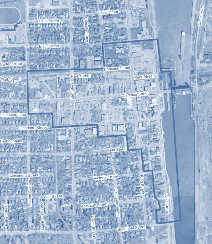
4 1.0 INTRODUCTION 1.1 Purpose This Directions Report is the second report in the Port Colborne Downtown Central Business District (CBD) Community Improvement Plan ( CIP ). The first report was a Background Report produced in September of 2009 that reviewed the legislative, policy and planning framework for the preparation of the Downtown CBD CIP. The Council of the City of Port Colborne designated the Central Business District Community Improvement Project Area on July 27, This area, also referred to in this report as the Project Area, is shown in Appendix A. The Directions Report is an interim report that forms a bridge between the public visioning workshops and the Urban Design Strategy and Community Improvement Plan reports. The general purpose of the Directions Report is to: Provide a summary of the analysis of strengths, weaknesses, opportunities and threats (SWOT Analysis) for the Downtown CBD completed by the consulting team with input received from the BIA and the general public during workshops held in November of 2009; Identify the Vision for the Downtown CBD that evolved out of the workshops; Review best practices in several other municipalities in Ontario, both within and outside the Niagara Region, who have prepared community improvement plans (CIPs) and introduced programs to promote revitalization of their downtown commercial areas; Identify a general direction for key physical improvements in the CBD, including built form, urban design, open space, and streetscape improvements, to be built upon and refined during the Urban Design Strategy report; and, Identify a general direction for potential financial incentive programs for the Downtown CBD to help guide preparation of the preliminary incentive programs to be considered for inclusion in the CIP. 1.2 Report Content This report is divided into several sections. Section 2.0 presents the results of the SWOT Analysis for the Downtown CBD. Section 3.0 outlines the vision for the Downtown CBD, This vision will form the basis for the Urban Design Strategy and the CIP. Section 4.0 provides the general direction for the physical improvements to Downtown Port Colborne and the required policy and regulatory amendments. Section 5.0 provides a summary of financial incentive programs used by a number of Ontario municipalities within and outside the Niagara Region to promote revitalization of their downtown areas. Finally, Section 6.0 provides the general direction for the preliminary financial incentive programs to be developed for inclusion in the Port Colborne Downtown CBD CIP. 1


5 2.0 SWOT ANALYSIS 2.1 Methodology A comprehensive analysis of strengths, weaknesses, opportunities and threats, or SWOT Analysis of the Project Area was undertaken to gain an understanding of the key issues and needs facing the Downtown CBD. Strengths and Opportunities are those characteristics and conditions that are deemed beneficial to the Downtown CBD thriving, whereas. Weaknesses and Threats are those characteristics and conditions that are deemed detrimental to the vitality of the Downtown CBD. The SWOT Analysis was comprised of both walking tours and visioning workshops. The consulting team undertook numerous walking tours of the Downtown CBD, including walking tours in June, July, and September of A follow up visit was conducted in November of During these walking tours, consulting team members took photographs, made observations and took notes with respect to the built form, physical characteristics and conditions, land uses and economic activity in the Project Area. In addition, the consulting team members also made observations regarding the strengths, weaknesses, opportunities and threats in the Project Area. The SWOT Analysis focused on a number of different themes or disciplines: Land Use: the different land uses and activities existing within the area; Built Form: the physical condition of buildings and their façades in the area; Urban Design: the composition of different elements and features within the area; Economic: the diversity of businesses and general business health in the area; Transportation: the condition of the transportation infrastructure in the area; and Servicing: the condition of the municipal servicing infrastructure in the area. The preliminary results of the SWOT Analysis were presented to the project steering committee 1 in October of Based on comments made by the steering committee and a follow up visit by the consulting team members to the Project Area, the SWOT Analysis was revised. The SWOT Analysis was then presented at two separate visioning workshops that were held on November 24, 2009: the first for members of the Downtown Port Colborne Business Improvement Area (BIA) and the second for members of the general public (Public Meeting). The purpose of the visioning workshops was to: a) present the results of the consulting team s SWOT Analysis for the Downtown CBD to the BIA and the general public; b) receive input from residents and business owners regarding the results of the SWOT Analysis; and, c) help residents and business owners identify a vision for the Project Area. 1 The project steering committee includes the Mayor, senior City staff, and representatives from the Downtown BIA and the St. Lawrence Seaway Authority. 2
6 The presentation made to the BIA and the general public was also made available on the City s web site. Approximately 13 people attended the BIA Workshop and approximately 10 people attended the public meeting. After the results of the SWOT Analysis were presented to both groups, attendees were asked during a workshop session to answer the following questions: 1. What do you think are the most significant weaknesses and threats in the Downtown CBD? 2. What do you think are the most significant strengths and opportunities in the Downtown CBD? 3. What is your vision for the Downtown CBD? If you went away and came back in 10 years, what would you like to see? 4. What types of public improvements would you like to see in the Downtown CBD? 5. What types of financial incentives do you think would be most attractive and utilized in Port Colborne s Downtown CBD? 6. What is your preference for traffic on West Street (Status quo; One-Way south from Clarence to Charlotte Street; One-Way south from Clarence to Kent Street)? Summary Notes from the BIA and public workshop sessions are contained in Appendix B. Attendees were also provided with comment sheets containing the above noted questions. Seventeen completed comment sheets and two free form comment letters were received and reviewed. The results of the SWOT Analysis (Questions 1 and 2 above) are provided in the remainder of Section 2.0 with a summary organized by Strengths & Opportunities and Weaknesses & Threats at the end of Section 2.0. The responses to the balance of the questions asked at the workshops are incorporated in the relevant sections of this report. 2.2 Land Use, Built Form and Urban Design Land Use From a land use perspective, the Downtown CBD is a relatively complete area containing retail and service commercial, residential, recreational, open space, and institutional uses. It contains a range of retail and commercial uses that provide the goods and services needed by residents on a day-to-day basis, such as grocery stores, financial institutions, and personal service businesses. Additionally, it contains several noncommercial destination and anchor uses that draw residents and visitors to the Downtown, including City Hall, a farmers market, a post office, museum and libraries, a number of churches, and other institutional uses. The Welland Canal attracts local residents as well as visitors and tourists. All these uses are supported by a significant amount on-street and off-street parking. The Downtown CBD generally has many of the elements that help to establish a vibrant downtown area. However, the Downtown has a relatively higher percentage of businesses that provides services and, consequently, a relatively lower percentage of shops that sell retail goods. Retail uses, and in particular distinct or specialty retail businesses, act as a community destination that draw both residents and visitors to the downtown and help create a more vibrant activity area throughout the day. The vibrancy of the downtown can be further enhanced by conversion of some of the vacant or underutilized upper stories of buildings into residential use, ensuring more people on the streets and using the shops and services in the Downtown CBD throughout the day. 3
7 2.2.2 Built Form Buildings in the Downtown CBD of Port Colborne are generally situated close to the street edge and represent the tight urban form desired for a downtown. Most buildings appear to be in relatively good physical condition. There are a large number of multi-storey buildings that provide height and the comfortable feeling of enclosure along the streetscape, while providing additional activity and floor space above the ground floor businesses. Lastly, there are several buildings with heritage features and façades that reflect the historic identity of the Downtown. This is a key visual asset given it provides continuity and design cues to new development and improvements to existing facades. However, while the structure of the built form is strong, the overall aesthetic quality and visual impression of private buildings in the Downtown CBD is poor. The façades of buildings are generally worn and dated and do not convey the traditional character and identity that is desirable for Downtown Port Colborne. Materials covering facades are often contemporary in nature and unsympathetic to the traditional character and history of the Downtown CBD. Signage for a large majority of buildings in Downtown is contemporary in style and materials and do not convey the character desired of a traditional main street environment. These weaknesses can project a negative image of Downtown Port Colborne and thereby threaten the ability of the Downtown CBD to attract new businesses and promote investment by existing businesses and property owners Urban Design The existing physical structure is one of Downtown Port Colborne s biggest assets when making improvements. Downtown s grid pattern of streets with short blocks, generally four blocks (Fielden Avenue to West Street) by four blocks high (Kent Street to Elgin Street), creates a compact and walkable urban form. Downtown has a strong built form pattern with buildings located tight to the street and framing the streetscape. Also there are a number of urban design landmarks that can be emphasized to strengthen the visual image and identity of the area, including the Clarence Street bridge, West Street, and views to the Welland Canal. These public realm strengths complement the overall building form, condition and buildings with heritage features and facades that reflect Downtown s historic identity. Similar to the issue with building facades, although the area s physical structure is strong, the quality of the image and visual impression of Downtown Port Colborne is lacking. Streets are solely functional in nature, generally lacking the consistent pattern of streetscape amenities that help make streets great public spaces. This includes amenities such as street trees, greenery and plantings, benches, bike racks, garbage receptacles, pedestrian lighting, and public art. The entrances, or gateways, to the Downtown CBD do not provide a strong first impression, while the lack of directional and wayfinding signage can make it difficult for new visitors to navigate the area. Lastly, the facades of buildings are generally worn and tired, including building signage, and do not convey the traditional character, identity or image that is desired for Downtown Port Colborne. 4
8 2.3 Economic Activity The statistics on business activity below are based on data collected in February of 2010 and provided by the Downtown BIA Strengths and Opportunities There are approximately 137 occupied businesses in the Downtown CBD project Area. These businesses include a broad range and mix of business types, including: 19 restaurants/cafes/fast food outlets; 13 beauty salons/hairstylists/spas/massage therapy; 10 financial services, insurance, real estate offices; 10 dental/medical clinics/offices; 9 gift stores; 6 professional offices; 6 banks/credit unions; 5 clothing stores; 5 bargain/thrift/vintage stores; 3 travel agencies; 3 gasoline/automobile service stations; and, 3 art galleries/museums. This represents a large number of businesses for a downtown of this size. The presence of a significant number of financial services offices, professional office and five banks/credit unions is also a very positive sign. Also, the Downtown CBD contains an abundance of service commercial uses. The Port Colborne Downtown CBD also contains a strong civic presence with the City Hall and a number of other anchor uses that draw significant numbers of people to the downtown. These anchor uses include: a large grocery store and 5 specialty food stores; a weekly farmer s market; a post office; 4 churches; 3 pharmacies/drug stores; 2 legion halls; and, Several institutional uses. These anchor uses represent places where people meet and interact and therefore provide drawing capacity for the Downtown CBD Weaknesses and Threats While containing a large number of service commercial businesses, retail shops selling consumer goods and higher order retailers are relatively under-represented in the Port Colborne Downtown CBD. There is also limited distinct or specialty retailing such as jewellery, electronics/computer, antiques, furniture and home décor stores. 5

9 As shown in Figure 1, there are eight vacant commercial buildings, plus several vacant upper and ground floor commercial units in the Project Area. In total, there are 19 vacant business addresses out of approximately 156 business addresses in the Project Area. This represents an approximate 12% commercial vacancy rate. This rate is cause for concern because a normal commercial vacancy rate attributable to business turnover in a downtown is about 5%-6%. As shown in Figure 1, several of the vacant commercial buildings are located on King Street and Clarence Street. A number of vacant upper floor commercial units are located on West Street. These commercial vacancies represent a weakness, and any increases in the vacancy rate would pose a threat to the health of the Downtown CBD. However, the vacant commercial buildings represent an opportunity to introduce new (currently underrepresented) commercial uses into the Downtown CBD. The vacant upper floors in commercial buildings also represent an opportunity to introduce new commercial uses, or to convert these vacant spaces into residential units to encourage more people to live downtown. This would provide a larger customer base for the business in the Downtown CBD. Figure 1 Commercial Vacancies in the Port Colborne Downtown CBD 6
10 2.4 Transportation A number of inputs were utilized to analyze transportation strengths, weakness, opportunities and threats for the Project Area. The City of Port Colborne provided a detailed traffic operations study for Port Colborne that was completed in December of This study provided data and analyses of traffic conditions in the City, including the Downtown area. Additional traffic counts were conducted by the consulting team in August 2009 to help further assess traffic patterns during summer months. The consulting team members also made observations regarding downtown traffic conditions during the walking tours. These tours included a visit to the downtown area during the Canal Days event to observe the pedestrian, traffic and parking conditions. Another major input has been the discussions with the various stakeholders, including local business representatives and City staff. A summary of the key strengths and opportunities and weaknesses and threats is provided below. One of the key issues in the Transportation SWOT Analysis is the possible change to one-way traffic operations on West Street, adjacent to the Welland Canal. Some initial options have been identified and these are also outlined below. These options will be further refined and the impact on traffic operations of these options will be investigated as part of the urban design concepts to be developed in the next stage of the CIP study Strengths and Opportunities The established grid street pattern within the Downtown CBD provides convenient circulation and mobility. The Project Area has a well established pattern of east west and north south streets that facilitate travel within the downtown for pedestrians and vehicles. The relatively small block sizes provide very convenient access to the various properties and the grid pattern of the streets helps reduce confusion in seeking specific downtown locations. The designated higher order streets (i.e., arterial and collector streets) are King Street, Elm Street, Clarence Street and Sugarloaf Street. Peak traffic volumes are relatively low in relation to the downtown street capacity. The primary streets such as King Street and Clarence Street have a potential capacity of about 12,000 to 14,000 vehicles per day (vpd). The current traffic volumes on the downtown streets range from approximately 1,000 vpd on the minor streets up to about 6,000 vpd on streets such as King Street and Clarence Street. The downtown intersections generally operate at high levels of service without extensive delay. This situation provides for the efficient accommodation of vehicular traffic at intersections while also offering flexibility to utilize the total available time and space for other needs such as pedestrians at intersections and parking along the streets. Availability of sidewalks on each side of downtown streets facilitates reasonable pedestrian circulation within a downtown. Most streets in Downtown Port Colborne have pedestrian sidewalks provided on both sides of the street. The availability of sidewalks helps accommodate pedestrian travel, particularly for seniors and persons with mobility limitations. The Downtown CBD streets have a significant supply of on-street metered parking in the downtown core and on-street unmetered parking on most other streets. There is also a substantial supply of centrally located public off-street parking in the parking lot in front of City Hall on Charlotte Street and in another parking lot on King Street. Based on general observations, this parking supply is not over-utilized and generally has enough vacant parking spaces to accommodate additional parking demand. One day a week (Fridays), the Charlotte Street parking lot is used for a farmers market and this creates high parking demand in the street blocks surrounding 7
11 City Hall. Also during special events such as Canal Days, the parking demand is higher and the available spaces are heavily utilized. Low volumes of peak period traffic and ample on-street parking supply may provide opportunities to utilize excess road space in the Downtown CBD to improve the pedestrian environment. These improvements could include widening sidewalks or even creating some bump out sections that can be used to improve the pedestrian environment and to provide enhanced street furnishings. It is noted that this may not be practical in some of the key areas, such as the King Street and Clarence Street intersection, or the section of Clarence Street between King Street and the Canal. It is however, a possible strategy for the busy area of West Street where existing sidewalk widths on the west side of the street do not provide the desired pedestrian environment Weaknesses and Threats There are a limited number of roadway and pedestrian links to the Downtown CBD from east of the Welland Canal and also from the Main Street (Regional Road 3) corridor. The Welland Canal has a limited number of roadway crossings and these crossings are closed when required to accommodate ship passage. Roadway crossings are provided at Main Street and Mellanby Ave/Killaly Street north of the downtown and at Clarence Street within the downtown. The Canal barrier reduces the connectivity between the downtown and the residential areas east of the Canal. Main Street (Regional Road 3) is the primary inter-municipal roadway facility connecting Port Colborne to the other area communities and it also forms a connection of the Highway 3 corridor. King Street and Elm Street form the primary connections between the downtown area and this major east west transportation corridor. Canal crossings subject to occasional closure and inconvenience for traffic. The Welland Canal operates typically for at least nine months of the year accommodating commercial and recreational boat traffic. During the summer months, the canal typically has between 15 and 25 ship passages daily that require the closure of the bridges. These closure periods of several on each bridge create an inconvenience for vehicular and pedestrian traffic. The local community is used to this situation and ships making their way through the Canal are a point of interest visitors and tourists. However, it does restrict traffic circulation to and from the Downtown CBD. Specific intersections such as Clarence Street and West Street, and Clarence Street and King Street are subject to higher vehicle collision levels. These intersections were identified in the 2003 Traffic Operations Study as having higher than average collision rates. The Clarence Street and King Street intersection does have a higher portion of turning traffic and limited auxiliary turning lanes which is a likely contributor to the higher collision rates. The Clarence Street and West Street intersection has a tight corner on the southwest quadrant with limited sight distance to the west and this intersection is also close to the Canal crossing with queuing through the intersection during bridge closures. Both of these conditions likely contribute to the higher than average collision rates at this intersection. Pedestrian sidewalk widths may be inadequate in busy areas. In some areas of the downtown the sidewalk widths are in the order of 1.5 metres. In other areas, the sidewalks are 3.0 to 3.5 metres in width. However, with utility poles, parking meters and other street fixtures, the clear walking path for pedestrians is usually less than the total sidewalk width. Typically, in low volume pedestrian areas, a clear walking path width of 1.5m is necessary to accommodate two persons side by side or meeting. In busy areas, a clear width of at least 3.5 metres is preferred to enable four persons to meet or walk abreast. 8
12 The 2003 Traffic Operations Study noted that the street crossing provision for pedestrians should be improved to ensure reasonable pedestrian safety. The primary area identified in the 2003 Traffic Operations Study was the use of uncontrolled pedestrian crossings and the Study proposed improved traffic control or signage and pavement markings. The street infrastructure (pavement, sidewalks) in the Downtown CBD is relatively old and requires ongoing maintenance expenditures. The roadways in many areas in the Downtown CBD are in need of maintenance and minor repairs to ensure an acceptable surface condition and to prevent deterioration towards break-up situations. The sidewalks are also relatively old, and in many cases, cracks and shifts in blocks have created uneven surfaces that are unpleasant to walk on and can create safety issues. The older street and sidewalk infrastructure in the Downtown CBD requires an allocation of funding resources to both prevent further deterioration and for upgrading and replacement West Street Options The scope of work for the CIP project includes a traffic impact study examining the potential benefits, challenges, feasibility and impact on the Downtown CBD of converting West Street from two-way traffic to oneway traffic. There are a number of reasons for examining this potential conversion of West Street to one-way traffic, including: the width of the sidewalk on the west side of West Street from Clarence Street to Charlotte Street constraining the potential for enhanced pedestrian activity in this section, the enhanced opportunities to develop outside, on-street merchandise display areas and patio areas in full view of the Canal, and improving traffic operating conditions at the constrained intersection of Clarence and West Streets. The existing conditions in the busy section of West Street between Clarence Street and Charlotte Street are shown in Figure 2. The road surface is two lanes wide and has an effective width of just under 8 metres. There is angled parking provided on the east side of the street and a sidewalk with some street plantings on the west side of the street. Due to the space used for plantings and other street infrastructure, the clear walking distance of this sidewalk is generally 3 metres or less. There are a number of retail and restaurant businesses fronting on West Street which receive deliveries from curb unloading on West Street. As well, some of the businesses on West Street receive deliveries from a rear lane which connects to Charlotte Street. However, not all the businesses fronting on West Street can be accessed via this rear lane. During the BIA and public workshop sessions, three options for traffic on West Street were presented to generate discussion and obtain input from business and property owners on West Street and the general public. The potential for converting West Street to one-way traffic generated considerable discussion as summarized in the BIA and workshop results contained in Section 3.0 of this report. The first option for West Street is the status quo shown in Figure 2, i.e., to simply leave the street as is (twoway traffic) without any changes to traffic direction, sidewalk or road widths. A second option is shown in Figure 3. This option is based on implementing one-way traffic on West Street in the southbound direction from Clarence Street to Charlotte Street. The roadway width would be reduced to 4.5 to 5 metres and the sidewalks widened by 2.5 to 3 metres. A truck unloading/loading area would be maintained to serve the local business needs with the proposed road width permitting vehicles to pass and emergency 9
13 vehicle access even if a truck stops to unload on the road. The direction of the angle parking would be changed to accommodate the southbound traffic direction. A third option for West Street is shown in Figure 4. In this option, the one-way traffic operation would be implemented from Clarence Street to at least Kent Street, and possibly as far south as Victoria Street. This would enable the street width on the west side of West Street between Charlotte Street and Kent Street/Victoria Street to be increased by about 3 metres, providing opportunities for streetscaping, wider sidewalks and street patio areas. No clear consensus emerged from the BIA Workshop or the Public Workshop regarding a preferred concept for West Street. Some business owners at the BIA Workshop supported a conversion of West Street to a one-way street while investigating the enhanced use of rear lanes for loading/unloading. These business owners argued that the wider sidewalks would allow more and larger sidewalk cafes and better overall use of the sidewalks. Still, other business owners did not see a need to convert West Street to one-way traffic, noting that this would remove a short cut to the Clarence Street Bridge and may reduce the ability of trucks to load/unload in front of stores on West Street. These business owners were also concerned that a one-way street could cause confusion and inconvenience for shoppers leading to a loss of business. Approximately 72% of those who filled out and submitted a comment sheet selected Option 3 (one-way south from Clarence Street to Kent Street) as the preferred option for traffic on West Street. Approximately 28% selected Option 1 (the Status Quo) as the preferred option. Interestingly, none of the respondents to the comment sheet selected Option 2 (one-way south from Clarence Street to Charlotte Street).The reasons cited in support of the Status Quo and Option 3 in the comment sheets were very similar to those mentioned at the workshops. However, one suggestion that did emerge from the BIA Workshop and the Public Workshop as well as the responses to the comment sheets public was the closing of West Street to vehicular traffic at certain times such as weekends, weekend evenings, or weekday and weekend evenings, or weekends only in the summer. Therefore, a fourth option for West Street was developed. This fourth option is a hybrid option with the design of West Street as a flexible street (can allow two way traffic, one way traffic, and closure) depending on different needs and events at different times and days throughout the year. This fourth option is further described in Section 4.1 of this report. All of the options for West Street will be further investigated in the next phase of the study (streetscape design) to confirm the feasibility, assess the impacts on overall downtown street traffic, and to determine a preferred approach. 10
14 Figure 2 West Street Option 1 Status Quo 11

15 Figure 3 West Street Option 2 One Way South from Clarence Street to Charlotte Street 12

16 Figure 4 West Street Option 3 One Way South from Clarence Street to Kent Street 13
17 2.5 Servicing This section of the report deals with the need for replacement/upgrading of underground services (water, sanitary sewer, storm sewer) in the Downtown CBD. Overall, servicing is not a major issue in the Downtown CBD. A number of streets in the Downtown CBD require storm sewer replacement. Only a few streets require sanitary sewer replacement. There are no watermain deficiencies, but there are a number of cast iron watermains that may require replacement as they age. Based on a review of documents supplied by the City of Port Colborne, the following is a list of deficient underground services in the Project Area that require upgrading. While there are currently no watermain deficiencies, the roads with old cast iron watermains have been highlighted for consideration. Fielden Avenue No deficient underground Elm Street Needs new sanitary sewer between Charlotte Street and Clarence Street Needs new storm sewer between Charlotte Street and Princess Street Cast iron watermain between Charlotte Street and Princess Street Catharine Street Needs new storm sewer from south of Charlotte Street to Park Street Cast iron watermains between Kent Street and Princess Street King Street Needs new storm sewer between Clarence Street and Princess Street West Street Needs new storm sewer between Clarence Street and Sugarloaf Street Cast iron watermain between Adelaide Street and Sugarloaf Street Princess Street Needs new storm sewer between Catharine Street and King Street Park Street No deficient underground Easement South of Park Street Needs new storm and sanitary sewer between Elm Street and Catharine Street Clarence Street Needs new storm sewer between Fielden Avenue and West Street Cast iron watermain between Catharine Street and West Street 14
18 Charlotte Street Needs new storm sewer west of Elm Street Cast iron watermain west of Elm Street Kent Street Needs new storm sewer between King Street and outlet at lake Cast iron watermain between King Street and West Street Victoria Street Cast iron watermain between King Street and West Street Adelaide Street Cast iron watermain between King Street and West Street Elgin Street No deficient underground 15


19 2.6 Summary This section contains a summary of the key strengths and opportunities and weaknesses and threats as identified through the SWOT Analysis and the BIA and public workshops. 2.3 Weakness and Thr eats Strengths & Opportunities Authentic area is a real downtown Complete broad range of uses and activities that serve the day-to-day needs of residents Loyalty many residents and visitors are attached to shopping downtown People residents living in and around downtown that shop in downtown Attachment many residents and business owners are interested in improving the downtown Landmark Bridge No. 21 over the Canal is attractive and a landmark feature in the downtown West Street strong heritage street with quality architecture Promenade great public space for residents and visitors Canal focal point within the community that residents may take for granted Friendly very friendly community and shop owners Neighbourhoods quality architecture in residential neighbourhood that are well maintained Reasonable affordable market and building prices Condition physically buildings are generally in good shape Proximity close to other communities in Niagara Region to draw visitors Specialty a few great specialty shops but they need to be nurtured and more specialty shops need to be added Draws number of activities that draw visitors to downtown, including farmers market, museum, and library Safe a safe and accessible downtown for visitors Walkable numerous walking paths and sidewalks to and within the downtown Form good urban form with buildings close to the street edge Parking good quantity of off-street and on-street parking Cyclists a lot of bicycle traffic accessing shops and services Traffic traffic is calm with relatively low traffic volumes Tourism number of draws for visitors in the municipality including events, beaches, marinas, and cottages 16


20 Weaknesses & Threats Financing obtaining financing for purchasing property and upgrades is difficult Overlooked West Street gets the focus for improvements while others areas are overlooked Tired business façades and signage are largely dated and tired Trees not enough trees in the downtown for comfort and a wind break Employees too many business employees are parking in prime spaces in the downtown Wayfinding lack of directional signage directing visitors to downtown features and confusion for visitors thinking Main Street is the downtown Connection transition between West Street and rest of downtown does not encourage visitors to turn the corner and continue Image the perception of Port Colborne from potential visitors is a problem Evenings there is a lack of evening activity and shops open in the evening Parking parking is not readily accessible to the businesses needing it Vacancy vacant storefronts give the wrong impression to visitors and need to be utilized Support with close neighbouring municipalities there is a need to focus on supporting businesses in Port Colborne Focus there is a lack of a central gathering space for residents, visitors and events Coordination better coordination of business activities and promotion of shopping opportunities in the downtown is needed Activity limited activities to do in downtown, particularly for youth Amenities few amenities along most streets including bike racks and benches Impression lack of a good first impression for visitors entering downtown Services much higher percentage of services as compared to the sale of goods Canal bridge closures interrupt connectivity between east and west sides of Canal Accommodation downtown needs more short-term accommodation options for visitors Hours hours of operation of shops and service are inconsistent 17


21 3.0 DOWNTOWN VISION A vision is a long-term strategic statement that identifies how the community, including property owners, business owners, and residents, wants its downtown to look, feel and function. A vision includes a broad range of elements, including the type and nature of uses and activities within the downtown; the features and amenities desired within the downtown; the opportunities for moving people around in the downtown; the feel or character of the buildings and spaces within the downtown; and the overall identity and image of the downtown. Establishment of a vision is a critical component of the CIP process because it provides the overarching, longterm foundation that directs the improvements and programs that form the CIP. The basis for a Vision for Downtown Port Colborne was generated at the visioning workshops with the BIA and the public on November 24, Workshop participants were asked to describe their vision for the Downtown CBD. Participants were specifically asked if you went away and came back in 10 years to the Port Colborne Downtown CBD, what would you like to see? The comment sheet responses to this question were also reviewed. The results from the community consultation led to an overarching vision for the Downtown CBD. This vision will be used to guide the formulation of the land use planning, urban design, streetscape, and incentive programs recommendations in the later phases of the CIP process. The vision statement for Downtown Port Colborne includes 12 principal elements. This vision statement identifies that over time, the Downtown CBD of Port Colborne will: 1) Maintain and enhance its real and authentic feel and character; 2) Be an active and vibrant commercial area at all times throughout the day and the year. 3) Have a greater variety of stores and have stores open longer hours; 4) Have more cafes and restaurants along the Welland Canal; 5) Have a strong visual and physical relationship with the Welland Canal and celebrate its history as a working port; 6) Be a more pedestrian and cycling friendly environment with sidewalks that have benches, street trees and street furniture; 7) Have great streetscapes including updated building facades and signage that are creative yet provide continuity and respect the historical context; 8) Have more people living downtown in a diverse range of housing opportunities; 9) Have a visually interesting, accessible and clean public realm; 10) Have more public gathering spaces; 11) Be easy for residents and visitors to travel within and navigate around; and, 12) Have better connections with the Canal, waterfront, marina, the community east of the Canal, and the Olde Humberstone commercial area along Main Street. 18
22 4.0 PLANNING AND URBAN DESIGN DIRECTION Improvements to a downtown s public realm, generally speaking, represent the largest financial investment of a CIP and are the longest in terms of timing and ultimate achievement. While there are always challenges associated with capital costs and timing, public realm improvements and high quality urban design are important elements for achieving the vision of Downtown Port Colborne as an attractive, vibrant and interesting space. Given this importance, the City of Port Colborne together with the Region of Niagara will have significant roles and responsibilities in designing and building the envisioned public realm needed to support the desired form and character for the Downtown CBD. The Urban Design Strategy, to be prepared as the next step in the CIP process, will provide the overall design principles, concepts and guidelines for physical improvements in the Downtown CBD. The Urban Design Strategy will identify recommendations for physical improvements to both public realm elements (including streetscapes, municipal parking areas, and public spaces) and private realm elements (including private buildings, façades and properties). The privately-owned buildings and properties that comprise the private realm of a downtown are also a significant element of the vibrancy of such an area. In vibrant and interesting downtowns, the shops within the private realm are typically what visitors are most involved with and experience. The buildings within the private realm provide a face to the downtown and are significant contributors to the definition of a particular character or identity for a downtown. Both property and business owners have an important role to play in improving the visual attractiveness and character of buildings and properties within the private realm of Downtown Port Colborne. However, private property and business owners must often be encouraged to play this role by witnessing public realm improvements and by taking advantage of incentive programs available from the municipality. Section 4.1 below identifies ten (10) principal general improvements to Downtown Port Colborne, in both the public and private realms, that will be explored and assessed as part of the Urban Design Strategy in the next steps of the CIP process. The policy and regulatory context that directs planning and design within the City is also a key component of the successful implementation of the design recommendations that will be made as part of the Urban Design Strategy. Given this, the Urban Design Strategy will explore and recommended any necessary changes to the principal policy and regulatory documents, including the City s Official Plan, Zoning By-law, and Sign By-law. Direction for changes to these three documents is provided in Section 4.2 below. Given that these documents are relatively new and have been recently updated or amended, it is anticipated that any recommended changes would be of a minor nature in the interests of further promoting appropriate, high quality design and development in Downtown Port Colborne. 19


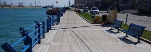
23 4.1 Physical Improvements The ten principal general improvements to the public and private realms in the Downtown CBD that will be explored and assessed as part of the Urban Design Strategy are: 1. West Street as a flexible street. 2. Clarence Street as a principal spine street. 3. King Street as a connector street to Main Street. 4. Remaining streets as secondary streets. 5. Bridge 21 as a community landmark. 6. A civic square as a focal point. 7. A comprehensive system of directional signage. 8. A coordinated system of gateway entrance features. 9. Improved edge treatment of properties. 10. Enhanced and updated façades West Street as a flexible street West Street is a unique street within Port Colborne and the Region of Niagara itself, given it is a street loaded only on one side with buildings and fronts the Welland Canal directly on the other side. West Street contributes considerably to the character and draw to Downtown Port Colborne given the architectural character of the buildings fronting the street, the Port Promenade along the east side of the street, and the historic context of the street. The terms of reference for the Downtown CBD CIP included consideration for converting West Street to a one-way street. Such a conversion stems primarily from some interest in expanding the sidewalk and boulevard realm along the west side of West Street, in order to allow private use of public streetscape space for sidewalk cafes, patios, and merchandise display. Additionally, turning movements at the West Street and Clarence Street intersection have been cited as an issue. 20
 that can adapt to different needs and events throughout the year.")

 to provide shorter crossings at intersections and allow plantings. Universal design standards concerning the design and placement of street furniture and amenities.")

, and the large number of")
24 The following general considerations will be part of streetscape design and traffic flow assessment for West Street during preparation of the Urban Design Strategy: Design of West Street as a flexible street (can allow two way, one way, and closure) that can adapt to different needs and events throughout the year. Seamless design of sidewalk and boulevard to enable spill out of restaurants and retail shops. Traffic flow assessment that will explore options for temporary street closure, unloading, two way traffic, and one-way traffic. Further tree planting within the outer boulevards (next to curb) along the entirety of West Street. Different textured materials for crosswalks to the Port Promenade at key intersections. Curb extensions ( bumpouts ) to provide shorter crossings at intersections and allow plantings. Universal design standards concerning the design and placement of street furniture and amenities. Native, non-invasive and salt tolerant planting species. Durable and easily maintainable surface treatments (poured concrete) for sidewalks and boulevards. A streetscape amenity package that has a consistent style, theme and materials. Dedicated on-street bicycling lanes where right-of-way width permits Clarence Street as Downtown s main street. Clarence Street is the primary east-west street through Downtown Port Colborne, and carries the most significant amount of traffic of the principal streets through the area. It performs the main street function of the downtown due to its traffic moving role, its connection to Bridge 21 (the only crossing of the Welland Canal in the Downtown CBD), and the large number of businesses and activities along the corridor. However, the quality of the Clarence Street streetscape (the visual image created by its many elements, including amenities, on-street parking, landscaping, and public spaces, and including building faces and storefronts) lacks character and visual interest, and is generally tired in appearance. 21


 for public sidewalks and sidewalk boulevards, with limited accents where deemed appropriate.")
25 The following general considerations will be part of streetscape design for Clarence Street during preparation of the Urban Design Strategy: Pedestrian orientation in order to provide a comfortable, clean, safe, visually interesting, and universally accessible environment. Tree plantings next to curb in a consistent spacing along the entirety of Clarence Street, where spacing and utilities permit, to create a tree canopy at its ultimate height. Different textured materials for crosswalks across all intersections to visually define pedestrian crossings. Curb extensions ( bumpouts ) to provide shorter crossings at intersections and to accommodate planting materials or resting areas at the corner. Universal design standards, such as curb ramps at intersections, on-street parking spaces for accessible transit vehicles, or the design and placement of street furniture and amenities. Planting species, both trees and foundation plantings, which are native, non-invasive and salt tolerant. Simple, durable and easily maintainable surface treatments (such as poured concrete) for public sidewalks and sidewalk boulevards, with limited accents where deemed appropriate. A streetscape amenity package (benches, trash and recycling receptacles, bike racks, or tree protection) that has a consistent style, theme and materials Dedicated on-street bicycling lanes in both directions where rightof-way width permits King Street as Downtown s connector street. King Street is a primary north-south street through Downtown Port Colborne. It connects the central area of Downtown Port Colborne to the Olde Humberstone Main Street area to the north, so it has the opportunity to be a strong northern entrance to the area. The street corridor contains a number of businesses as well as the cultural focus of the downtown, including the library, museum and archives. While it does not perform the same main street function as Clarence Street, it has a particularly important role of connecting two of the City s principal commercial areas, the Downtown and the Main Street area. However, similar to Clarence Street the quality of the King Street streetscape is lacking character and visual interest. 22


 that perform a secondary function in moving traffic and generally have lower traffic volumes than the primary streets")

26 Considerations for the streetscape design of King Street during preparation of the Urban Design Strategy will be similar to those for Clarence Street. Additional considerations include the visual and physical transition northwards to Old Humberstone Main Street area; coordination of the streetscape elements potential gateway features surrounding the Elgin Street intersection; and recognition and emphasis of the City s civic district with the museum, library, and archives The remaining streets as Downtown s secondary streets Downtown Port Colborne benefits considerably from a regular grid pattern of streets that creates small blocks and opportunities for easy and distributed circulation patterns for all forms of movement, including driving, walking and cycling. There are a number of remaining streets in Downtown Port Colborne (such as Elm Street, Catharine Street, Charlotte, Kent Street) that perform a secondary function in moving traffic and generally have lower traffic volumes than the primary streets identified above. Generally, only small segments of these streets are within the defined downtown boundary and the remaining segments are largely residential nature. Considerations for the streetscape design of these secondary streets will be similar to the primary streets, however, the concentration of design amenities would naturally be less and improvements would be lower priority in terms of timing as compared to the primary streets of Clarence Street and King Street. 23
 over the Welland Canal physically symbolizes the identity and character of Downtown Port Colborne.")


; addition")
27 4.1.5 Bridge No. 21 as landmark The Clarence Street Bridge (Bridge No. 21) over the Welland Canal physically symbolizes the identity and character of Downtown Port Colborne. The bridge s impressive character, form and style, in addition to its scale and height, create a visual focal point within the community. Additionally, the bridge feature provides an impressive vista looking eastwards along Clarence Street as one approaches the Welland Canal. Bridge No.21 is a landmark feature in Downtown Port Colborne, with viewlines from many vantage points in the area, and should be emphasized. Considerations for emphasizing Bridge No. 21 during the preparation of the Urban Design Strategy will include lighting features at night; enhanced signage identifying the bridge; coordination with an eastern gateway feature (possibly as part of the bridge structure); addition or enhancement of sitting and watching areas surrounding the bridge; and Street tree planting along both sides of Clarence Street to frame the vista from the west to the bridge. Any design elements or improvements will need to recognize and not interfere with the function of the bridge along the Canal and would need coordination with the Seaway Authority. 24


; A resting and gathering place for day-to-day visitors; Continued commemoration space as necessary;")
28 4.1.6 Market Square as the civic focus of the Downtown CBD Downtowns are key areas within a town for gathering, socialization and passive recreation purposes, thus they need spaces that can accommodate such functions. While Downtown Port Colborne does have a green memorial space and central parking lot space, this space does not capitalize on the full potential of its central location for a multi-purpose and multi-functional focal point within the Downtown. Such a space should be established in Downtown Port Colborne to provide a range of opportunities for socialization, resting and community events or functions within the area. The existing memorial space and public parking lot on Catharine Street between Clarence Street and Charlotte Street presents a significant opportunity for such a space. Considerations for emphasizing establishing a civic square in this location, or other potential locations, during the preparation of the Urban Design Strategy will include: Accommodation of regular community events (farmer s market, music events, etc); Accommodation of community special events (Canal Days, other festivals, etc); A resting and gathering place for day-to-day visitors; Continued commemoration space as necessary; Information and directional kiosk for visitors and tourists; Accommodation of some surf ace parking when events not taking place, or alternative locations for central parking areas; Surface treatment that is durable and multi-functional in nature; and Design that accommodates multi-seasonal use. 25


29 4.1.7 Comprehensive system of wayfinding signage Successful downtowns include measures to enable visitors to be able to comfortable, easily, and safely navigate throughout the area. Directional, or wayfinding, signage performs such a function by directing visitors, whether arriving by walking, cycling, transit or driving, to the key destinations within a downtown. These destinations may be civic buildings, parking areas, open spaces and trails, and other significant destinations or features. Downtown Port Colborne has a number of significant elements that may draw the interests of visitors, but currently there is no such system in the area that direct visitors to these elements. Incorporation of an overall system of wayfinding signage within the Downtown CBD will be explored as part of the Urban Design Strategy. Considerations for wayfinding signage will include: Principal locations along Clarence Street and coordinated with gateway entrances; Simple and universally readable signs; Style and type of signs consistent with the overall streetscape amenity package; Coordination (and parallel theme) with the style, design and placement of any wayfinding signage installed as part of the Olde Humberstone Main Street work; and Distinction of wayfinding signage within Downtown through unique colours and images or graphics. 26


30 4.1.8 Coordinated gateway entrance features The gateways to a downtown are located at key arrival points for visitors. The installation of gateway features in these locations present significant opportunities to provide a positive first impression of a downtown to visitors by providing visual interest along the streetscape reflective of the particular character or features of the community. Currently there are not any gateway features at the primary entrances to Downtown Port Colborne. The specific design and location of gateway features within Downtown Port Colborne will be explored as part of the Urban Design Strategy. Considerations for the gateway features will include: Style and materials that are consistent with the context of the downtown area and the history of the community in general; The durability and ease of maintenance when selecting materials and styles; Complementary native and hardy plantings surrounding the feature to emphasize and provide visual interest; The possibility of a series of primary and secondary gateway features based on location, which differ in terms of scale and size; and Potential coordination or paralleling of the style and theme of any gateway features planned as part of the Olde Humberstone Main Street area. 27
 and many multi-storey buildings.")

.")


31 4.1.9 Improved edge treatment for properties The built environment in Downtown Port Colborne is characteristically urban, with the large majority of buildings sited tight to the street edge (i.e. zero front yard setbacks) and many multi-storey buildings. This helps to create a comfortable walking, and ultimately shopping, environment for visitors to Downtown Port Colborne. There are however several instances of properties, particular near the western end of the Downtown along Clarence Street, that have a more contemporary commercial built form pattern, including buildings set back from the street edge, parking areas in front of buildings, and multiple access points (some along the most of the property frontage). The building voids along the street and disruptions of the sidewalk where driveways cross create an uncomfortable area for pedestrians and not encourage visitors to walk in such situations. These buildings and activities on these properties would be expected to continue for the foreseeable future. With this in mind, improvement to the property edges should be encouraged to better frame the public sidewalks along the street. Specific property improvements will be explored as part of the Urban Design Strategy, which may include strengthening the edge of such properties with landscaping and greenery while consolidating driveway accesses where possible. 28


32 Enhanced and updated facades. Downtown Port Colborne contains a strong urban built form pattern with buildings located close to the street edge. Additionally, Downtown contains an existing stock of quality heritage buildings, particularly along West Street but also elsewhere, which add to the character and identity of the area. Most buildings are in good physical condition and generally appear to be well-maintained. However, the visual quality of facades in Downtown Port Colborne is generally poor, with many facades that are worn and dated and lacking the character expected of a small town downtown area. There are a wide range of facade conditions in Port Colborne that warrant improvement: Covering of original facades with contemporary siding; Deteriorating architectural features such as ornate brickwork or roofline; Fascia signage that is weathered and dated; Inappropriate signage types within a main street environment; Fascia signage not in a desirable location and out of character with the façade proportions; Facade colours that are distracting and that overshadows building features; Fascia signage using synthetic materials not in keeping with a main street character; Installation of upper storey windows that do not respect original window openings; Blocking of views into shops through non-transparent materials or glass treatment. Based on these conditions, facade improvements throughout Downtown Port Colborne should be encouraged, in order to develop a more coherent, creative and attractive appearance. Such efforts could include improvements to signage placement and treatment; door and window design and location; awning and canopy installation; facade materials; roofline design and treatment; and pedestrian-oriented lighting. The overall goal should be facade improvements that are sympathetic and consistent with the desired small town, main street character for Downtown Port Colborne. 29
33 4.2 Policy and Regulatory Amendments The policy and regulatory context that directs planning and design within the City is a key component of the successful implementation of the design recommendations that will be made as part of the Urban Design Strategy. Given this, the Urban Design Strategy will explore and recommended any necessary changes to the principal policy and regulatory documents, including the City s Official Plan, Zoning By-law, and Sign By-law. Direction for these three documents is discussed below. Given these documents are relatively new and have been recently updated or amended, it is anticipated that any recommended changes would be of a minor nature in the interests of further promoting appropriate, high quality design and development in Downtown Port Colborne Official Plan The City s Official Plan provides the general land use framework and policies for the city by identifying generally how, where and when the city will develop over time. City Council recently adopted a revised Official Plan in 2006 (the New Official Plan ), which at the time of writing of this Directions Report is pending Regional approval and is not in full force. Given the revised Official Plan will be the document guiding future planning decisions in the Downtown CBD, the following elements of the New Official Plan will be reviewed as part of the Urban Design Strategy and recommendations for amendments to the Official Plan may be proposed: Land use: the range of uses permitted in Downtown Colborne; Urban design: the design and layout of buildings, facades and properties in Downtown Port Colborne; Streetscape: the design direction, where applicable, for any streets within Downtown Port Colborne; Implementation: any relevant implementation measures for Downtown Port Colborne Zoning By-law By-law No. 1150/97/81, the City s Zoning By-law regulates, among other elements, permitted uses, building height, parking requirements, and building setbacks. The Zoning By-law was adopted by City Council in 1981 and approved by the Ontario Municipal Board in A zoning by-law is a primary planning tool for implementing the vision of the Official Plan, as well as any recommendations made through the CIP process. As part of the Urban Design Strategy, the following elements of the Zoning By-law will be reviewed and recommendations for amendments to the Zoning By-law may be proposed: Downtown zoning regulations for other similar sized municipalities in Ontario for comparison purposes; List of permitted uses in the downtown; Parking requirements and any parking exemptions for downtown uses; Regulations for yard setbacks, particularly front yard setbacks; and, Regulations for building scale, including height, width, and massing Sign By-law By-law No. 4738/120/05, the City s Sign By-law, regulates the type, size, scale and location of a signs within Port Colborne. Signage is an important component of the overall aesthetic of a downtown and, accordingly, municipal regulations and requirements regarding signage are critical to ensure that signage is in keeping with the scale and character of the particular community. As part of the Urban Design Strategy, the following will be reviewed and recommendations for amendments may be proposed: 30
34 Any types of signage that are not appropriate in a main street environment; Any size restrictions (sign face area, height, width and lettering height) and the potential negative impacts on the overall façade; Any locational criteria that may be inappropriate or lacking for a main street environment; and Consistency with any façade improvement design guidelines that are developed; and Any limits on the number of signs per property to limit over-signing. 31
35 5.0 SMARTER NIAGARA INCENTIVE PROGRAMS The Smarter Niagara Incentive Programs were endorsed by Regional Council in The Smarter Niagara Incentives Program contains several incentive programs and these are described below. The Region has established that it will provide a matching proportionate share of any financial incentive offered by an area municipality, subject to a maximum share from the Region as specified in the Smarter Niagara Incentive Programs. Efforts have been ongoing to implement these programs since 2002 and the Region has budgeted funds for the implementation of these programs. The Region and area municipalities in Niagara have established a Region/Area Municipality Incentive Coordinating Committee to coordinate the provision of these incentives through local community improvement plans. The City of Port Colborne can only take advantage of these programs to promote revitalization in the Downtown CBD by preparing and adopting a CIP for this area. 5.1 Reduction of Regional Development Charges In Downtown Areas, the Region offers a reduction of 50% of the Regional development charge for new residential, commercial or institutional development or conversion of existing buildings to those uses. An additional 50% Development Charge reduction is available to developments that include Smart Growth design principles into the proposed development. While the Region encourages local municipalities to establish a reduction program for local development charges in central urban areas, the Reduction of Regional Development Charges is available even if the local municipality does not have a similar program. 5.2 Property Rehabilitation and Redevelopment Tax Increment Funding Program The purpose of this grant is to stimulate building and property rehabilitation or redevelopment. This includes downtown sites and brownfield sites. The Region will match the percentage of the tax increment generated by a rehabilitation or redevelopment project that is paid by the municipality in the form of a grant to the applicant. Because the Regional tax share is larger than the local municipal tax share, this means that the Region will contribute more to the tax increment based grant than the local municipality. 5.3 Building and Facade Improvement Grant/Loan Program The purpose of this program is to promote the structural improvement of buildings and/or the improvement of building facades. The Region will provide a matching grant or loan on a cost shared basis with the local municipality to a maximum grant from the Region of $5,000 per property, or a matching loan from the Region of $10,000 per property. 5.4 Residential Grant/Loan Program The purpose of this program is to promote residential conversion, infill and intensification. The Region will provide a matching grant or loan on a cost shared basis with the local municipality to a maximum grant from the Region of $5,000 per unit and 20 units per property, or a matching loan from the Region of $10,000 per unit. 32
36 5.5 Heritage Restoration and Improvement Grant/Loan Program The purpose of this program is to promote the restoration and improvement of buildings designated under the Ontario Heritage Act. The Region will provide a matching grant or loan on a cost shared basis with the local municipality to a maximum grant or loan from the Region of $2,500 per residential property and $10,000 per commercial or industrial property. 5.6 Environmental Assessment Study Grant Program The purpose of this program is to promote the undertaking of environmental site assessments so that better information is available with respect to the type of contamination and potential remediation costs on brownfield properties. The Region will provide a matching grant on a cost shared basis with the local municipality to a maximum grant from the Region of $5,000 per property to promote the completion of Phase II Environmental Site Assessments, Remedial Action Plans and Risk Assessments. 5.7 Public Domain Incentives Program This program was introduced in The Region will provide a matching grant on a cost shared basis with the local municipality to a maximum grant from the Region of $100,000 per project to support public realm improvements already identified in or in compliance with municipal planning documents including CIPs, Secondary Plans or Official Plans. This programs is based on a competitive evaluation process whereby the project must meet the Region s eligibility criteria. These criteria include a green component constituting a minimum of 6% of overall project cost and compliance with local or Regional urban design guidelines. Preference will be given to projects that include heritage and/or public art components. 33
37 6.0 FINANCIAL INCENTIVE PROGRAM BEST PRACTICES 6.1 Introduction Based on the analysis conducted in this report, the Port Colborne Downtown CBD has a number of key weaknesses and threats to revitalization and redevelopment. However, these weaknesses and threats can be overcome and potential opportunities in the Downtown CBD can be maximized through the provision of financial incentives that adequately encourage downtown redevelopment. According to the Ministry of Municipal Affairs and Housing Community Improvement Planning Handbook (2006), there are currently dozens of Ontario municipalities with community improvement plans in place to promote downtown revitalization and redevelopment. With relevance to the types of community improvement required in Downtown Port Colborne, the following is a brief overview and summary of some of the community improvement plan initiatives undertaken by ten (10) municipalities across Ontario. The municipalities in the Niagara Region with approved and active downtown CIPs were included in the comparison to see how their CIPs have been structured to take advantage of the Smarter Niagara Incentive Programs available from the Region of Niagara. This includes CIPs in the City of St. Catharines, City of Niagara Falls, City of Welland and City of Thorold. While the Downtown CBD is considered the downtown of Port Colborne, the Port Colborne Old Humberstone CIP was also included in the best practices review for comparative purposes. The Municipality of Chatham-Kent and the City of Cambridge were included because they both have considerable experience with CIP programs and a comprehensive range of programs. Finally, in addition to the City of Thorold (18,244) which has a population almost identical to the City of Port Colborne (18,600), a few smaller Ontario municipalities similar in population size were included in the analysis. These include the Municipality of Trent Hills (12,250) in Campbellford, City of Kenora (15,000), and the City of Owen Sound (22,000). The inclusion of these smaller municipalities will provide some idea as to the type, focus and size of incentive programs in smaller municipalities. As shown in Figure 5, the ten municipalities in the comparison offer a wide range of incentive programs to promote downtown redevelopment. With the exception of the City of Thorold which offers only three programs, and the Municipality of Chatham-Kent which offers ten programs, most of the municipalities in the comparison offer four to six programs. The Olde Humberstone CIP offers eight different program types. As shown in Figure 5, the value, duration and type of incentive program varies from municipality to municipality. Some of the smaller municipalities tend to offer smaller grants and loans for certain types of community improvement when compared to the larger municipalities. Also, only one of the four smaller municipalities (Thorold) offers a development charge exemption while all of the larger municipalities offer a development charge exemption. The analysis in this section compares the municipalities by type of incentive program offered. This analysis provides best practices that can inform and assist in developing a package of incentive programs that will help to address some of the key weaknesses and threats and help to promote revitalization in the Port Colborne Downtown CBD. 34
38 Figure 5 Summary of Municipal Downtown/ Commercial Area Redevelopment Incentive Programs Municipality Type of Program St. Catharines Niagara Falls Welland Thorold Port Colborne Olde Humberstone 1) Development Charge Waiver/ Exemption 2) Tax Increment (TI) Based Grant 3) Building/Facade Improvement Grant/ Loan 4) Residential Conversion/ Intensification Grant/ Loan 5) Project Feasibility Study Grant 6) Urban Design Study Grant 100% City development charge exemption. 50% to 100% Regional development charge reduction. Annual grant for up to 9 years. Grant of 90% of TI in first year, 10% less each year thereafter Grant for 50% of cost of facade improvement to maximum grant of $10,000 per building Grant of 15% of unit construction cost to a maximum grant of $5,000 per unit. 75% City development charge exemption. 50% to 100% Regional development charge reduction. Annual grant for up to 10 years. Grant of 80% of TI in years 1 to 5, 60% in years 6 and 7, 40% in year 8, and 20% in years 9 and 10. Grant for 50% of cost of building and facade improvement up to a maximum grant of $10,000 per property. 5 year interest free loan for building improvement up to $15,000 loan per property. 5 year interest free loan on basis of $20 per sq.ft. space created to a maximum loan of $20,000 per unit. Maximum loan of $500,000 per property. 100% City development charge exemption. 50% to 100% Regional development charge reduction. Annual grant for up to 10 years. Grant of 80% of TI in years 1 and 2, 70% in years 3 and 4, 60% in year 5, and 10% less each year thereafter. Interest free loan for 50% of cost of facade improvement to a maximum loan of $20,000 per property. 10 year interest free loan on basis of $10 per sq.ft. space created. 75% to 100% City development charge exemption. 50% to 100% Regional development charge reduction. Annual grant of 80% of TI for up to 10 years. Grant for 50% of cost of facade improvement up to a maximum grant of $10,000 per property. Annual grant of 100% of TI for up to 3 years. Grant for 50% of cost of front facade improvement to a maximum grant of $10,000 per property plus Grant for 50% of cost of side/rear facade improvement to a maximum grant of $5,000 per property Grant for 50% of construction cost to a maximum grant of $3,000 per new unit and $1,000 per rehabilitated unit. Grant for 50% of construction cost of an affordable unit to a maximum grant of $2,000 per unit. Grant for 50% of cost of architectural drawings to a maximum grant of $500. Grant for 50% of cost of site plan to a maximum grant of $500. Chatham-Kent Cambridge Trent Hills Kenora Owen Sound 100% development charge rebate. Annual grant of 100% of TI for up to 5 years. Grant for 50% of cost of facade improvement to a maximum grant of $7,500 per property. 5 year interest free loan for 50% of cost of facade improvement to a maximum loan of $20,000. Grant for 50% of construction cost to a maximum grant of $5,000 per unit and $40,000 per application. 5 year interest free loan for 50% of construction cost to a maximum loan of $10,000 per unit and $80,000 per application. Grant for 50% of cost of study to a maximum grant of $5,000 Grant for 50% of cost of a heritage design study to a maximum grant of $1, % City and Region development charge exemption. Up-front grant of up to 100% of remediation costs for brownfields only to a maximum grant of $1,500 per residential unit or $10 per sq.m. non-residential 3,4,or 5 year interest free loan for 50% of cost of building and facade improvement with up to 35% of loan as a grant (forgivable loan). Maximum loan amount of $20,000 per building, and $60,000 per owner Grant for 50% of cost of an urban design study to a maximum grant of $1,750. Annual grant of 100% of TI for up to 5 years Grant for 50% of cost of facade improvement to a maximum grant of $12,000 per property. Grant for 50% of construction cost to a maximum grant of $5,000 per unit and $20,000 per property. Grant for 50% of cost of an urban design study to a maximum grant of $1,000. Grant for 50% of cost of facade improvement to a maximum grant of $15,000 per building, plus $1,000 increase for each additional storey over two storeys. Grant for 50% of cost of an urban design study to a maximum grant of $500. Grant equivalent to up to 100% of development charge for residential construction only. Annual grant for up to 5 years. Grant of 80% of TI in year 1 and 20% less each year thereafter. Council has option for 10 year grant as well. Grant for 33% of cost of facade and building improvement to a maximum grant of $5,000 per project per year. 35
39 Figure 5 (Cont d) Summary of Municipal Downtown/ Commercial Area Redevelopment Incentive Programs Municipality Type of Program St. Catharines Niagara Falls Welland Thorold Port Colborne Olde Humberstone 7) Planning and Building Permit Fee Grant/Rebate 8) Business Signage Grant/Loan 9) Landscaping and Property Improvement Grant 11) Reduced Parking Requirements 10) Reduced Parkland Dedication Requirements 100% refund of planning application and building permit fees 50% refund of planning and building permit fees for non-residential projects. 100% refund of planning and building permit fees for residential projects. Waiving or reduction of residential parking requirements 100% refund of application fee for: - Site Plan - Rezoning - Minor Variance 50% refund of building permit fee to a maximum of $500. Grant for 50% of cost of replacing existing signage to a maximum grant of $2,000. Sidewalk cafe grant of 50% of cost of creating or improving restaurant sidewalk cafes to a maximum grant of $2,000. Grant of 50% of cost of connecting to rear parking areas to a maximum grant of $3,000. Grant of 50% of cost of constructing rear lot paved shared parking to a maximum grant of $500 per space and $1,000 per 10 m length of access laneways. Chatham-Kent Cambridge Trent Hills Kenora Owen Sound 100% rebate of planning and building permit fees. For residential units, parking standards are waived or 100% cash in lieu is rebated For residential units, parkland dedication requirements are waived or 100% cash in lieu is rebated 100% waiver of planning and building permit fees Up to 100% rebate of planning and building permit fees, depending on fee amount. Parkland dedication requirements are waived or 100% cash in lieu is rebated 100% rebate of planning and building permit fees. Grant for 50% of cost of new signage to a maximum grant of $2,000 Grant for 50% of cost of landscaping and property improvement to a maximum grant of $2, ) Heritage Tax Relief Grants for 40% reduction in municipal portion of postrestoration property taxes for 5 years following completion of work. Number of Programs Rebate of planning and building permit fees for façade type improvements only. 36
40 6.2 Development Charge Waiver/Exemption As an incentive to promote development on vacant lots and the conversion to and addition of new residential units and commercial space to existing buildings, seven of the ten municipalities in the comparison offer a partial or complete waiver of development charges normally payable. Generally speaking, the waiving of development charges is the most attractive of all the types of financial incentives used to promote downtown redevelopment because the financial benefit to the developer can be very large. Also, the financial benefit accrues to the developer earlier in the development process, i.e., usually at the time of building permit, as compared to a tax increment based grant where the developer must wait for up to ten years after development to recoup costs. In the Niagara Region, St. Catharines and Welland offer a 100% exemption from development charges in their downtown areas. Niagara Falls and Thorold offer a 75% development charge exemption with an additional 25% available to those developments that incorporate Smart Growth principles such as intensification, mixed uses, a range of housing choices, and elements that create a walkable neighbourhood character. This approach emulates the Region s approach to development charge reduction. The Region provides a reduction of 50% of the Regional development charge payable in downtown areas, with a potential bump up from 50% to 100% for the incorporation of Smart Growth principles. The area of Port Colborne designated as eligible for the Regional development charge reduction includes the entire designated CBD Community Improvement Project Area. The City of Welland has gone one step further with the incorporation of Smart Growth principles into its Brownfield CIP. The additional 25% development charge exemption for brownfield sites is tied not only to the incorporation of Smart Growth principles into the development, but also the Leadership in Energy and Environmental Design (LEED) standard achieved by the development. A development charge waiver/exemption program does not fall within the parameters of Section 28 of the Planning Act. Therefore, such a program is normally implemented through an amendment to the municipality s development charges by-law. However, a development charge equivalent grant can be implemented through the CIP under Section 28 of the Planning Act although this approach is rarely used. In this case, the developer would pay the normal development charge at the time of building permit issuance. At project completion, the developer would then be provided with a grant equivalent to part or all of the development charge paid. 6.3 Tax Increment Based Grant As shown in Figure 5, tax increment based grants have become a very popular tool for promoting downtown redevelopment. With a tax increment based grant, the municipality uses part or all of the municipal property tax increase (increment) generated by a redevelopment project to provide an annual grant to the developer for a period of time to help pay for the costs of redevelopment and reduce the impact of the large property tax increase that often accompanies a redevelopment project. This tax increment based grant can and has been used by developers and property owners to assist in securing financing for downtown redevelopment projects. With the exception of the Olde Humberstone CIP, all of the Niagara municipalities in the comparison offer very generous tax increment based grants. These grants are paid out for up to 10 years after project completion. The City of Thorold offers the most generous tax increment based grant of all the municipalities in the comparison at 80% of the tax increment for ten years. The other Niagara municipalities utilize a sliding tax increment scale with a lesser tax increment offered in later years. The use of a sliding scale is less attractive to 37
41 developers and this practice has been criticized as less conducive to promoting interest from developers. The Olde Humberstone CIP includes an annual grant equal to 80% of the tax increment, but this grant is provided for only three years, making it uncompetitive. The Region of Niagara will match the percentage of the tax increment based grant provided by the local municipality through a CIP. Again, the City of Welland has incorporated Smart Growth principles into its Brownfield CIP by providing a much higher municipal tax increment for brownfield redevelopment projects that are LEED certified. Each higher level of LEED certification receives a higher annual tax increment based grant. Chatham-Kent, Trent Hills, and Owen Sound offer their tax increment based grants for a shorter period of time, i.e., up to 5 years. Chatham-Kent and Trent Hills offer a grant of 100% of TI for up to 5 years, while Owen Sound offers its five year tax increment based grants on a sliding scale. Kenora is the only municipality in the comparison that does not offer a tax increment based grant to promote downtown redevelopment. The City of Cambridge used to offer a three year sliding scale tax increment based grant, but this grant was discontinued due to a lack of interest on the part of developers and the reluctance by the Region of Waterloo to provide a matching tax increment grant. Instead, the City of Cambridge offers a modest direct grant for residential units and commercial space constructed on brownfield sites that have been remediated. Experience in numerous Ontario municipalities suggests that a tax increment based grant of less than five years will not be effective. The preferred tax increment based grant period is ten years. Also, as opposed to a sliding scale, a fixed tax increment scale at a higher level, say 80% or more, provides the magnitude of incentive that is required to encourage adaptive reuse, intensification, infill and redevelopment in the form of new construction. 6.4 Building and Facade Improvement Grant/Loan Eight of the ten municipalities in the comparison provide some form of grant to promote facade improvement. These are matching grants where the owner is required to pay 50% of the cost of the facade improvement and the municipality pays the other 50% of the cost to a set maximum. The maximum amount of these grants ranges from $5,000 in Owen Sound to a generous $15,000 in Kenora and $15,000 (front and side/rear façade) in the Olde Humberstone CIP. Surprisingly, even though they are two of the smaller municipalities in the comparison, both Kenora and Trent Hills offer the largest facade improvement grants at $15,000 and $12,000 respectively. St. Catharines, Niagara Falls and Thorold also offer a generous façade improvement grant at $10,000 each. A few of the municipalities in the comparison (Welland, Chatham-Kent, Cambridge) also offer an interest free loan for facade improvement. As with the grants, these are matching loans for 50% of the cost of the facade improvement to a maximum loan amount. The maximum loan amount is $20,000 in Welland, Chatham-Kent and Cambridge. Welland and Cambridge offer only a loan for facade improvement (no grant), while Chatham- Kent offers both a grant and a loan program. In addition to the facade improvement programs, some of the municipalities such as Niagara Falls and Cambridge also offer grants and loans for building improvements such as replacement of doors and windows, structural repairs, awnings and new signage. From an administrative perspective, a grant program for facade/building improvement is preferable to a loan program which requires ongoing administration over a period of time. However, a loan program has the benefit of replenishing initial seed funding put in place by the 38
42 municipality via a revolving loan fund as the loans are repaid. The dual grant/loan approach employed by some of the municipalities is very flexible as it allows applicants to use the grant component alone for smaller, less expensive facade improvement projects, and the grant combined with the loan for larger, more expensive projects. 6.5 Residential Conversion/Intensification Grant/Loan One of the keys to downtown revitalization for many municipalities is to have more people living downtown, and therefore shopping downtown and supporting downtown businesses such as restaurants, service and specialty shops. Attracting more people to live downtown is accomplished through residential infill construction on vacant lots, intensification and upgrading of existing residential and mixed use buildings, and the conversion of excess/vacant upper storey commercial space into residential units. Six of the ten municipalities in the comparison offer incentive programs to promote residential conversion and intensification. Port Colborne, St. Catharines, Chatham-Kent and Trent Hills offer grants for the construction of new residential units. The Olde Humberstone CIP in Port Colborne offers a grant that pays 50% of the cost of residential construction to a maximum grant of $3,000 per new unit and $1,000 per rehabilitated unit. This is the smallest of the residential conversion/intensification grants in the comparison, and again this is not competitive with the other municipalities offering residential conversion/intensification grants. However, Port Colborne is the only municipality to offer a grant for the construction of an affordable residential unit. St. Catharines offers a grant for 15% of unit construction costs to a maximum grant of $5,000 per unit. St. Catharines used to offer a grant for 15% of unit construction costs to a maximum grant of $15,000 per unit and a maximum of $250,000 per project. However, over the last few years, the City of St. Catharines received more applications for this grant than it had budget available. This led to applications being rejected by St. Catharines Council and criticism of the program from developers. Therefore, the City of St. Catharines revamped the program to lower the maximum grant amount. It is important for any municipality contemplating use of a residential conversion/intensification grant to evaluate the potential amount of take up and timing of the take up of such a program in their downtown area. This will allow the municipality to properly structure and budget for this type of program. Chatham-Kent offers a residential conversion/intensification grant that pays 50% of the cost of residential construction to a maximum grant of $5,000 per unit and $40,000 per application. Trent Hills is the only other smaller municipality that offers a grant for residential intensification/conversion with a grant that pays 50% of the cost of residential construction to a maximum grant of $5,000 per unit and $20,000 per property. It is likely more difficult for smaller municipalities to afford a generous residential conversion/intensification grant program. Three of the ten municipalities in the comparison offer an interest free loan to promote residential conversion/intensification. The City of Niagara Falls offers a generous five year term interest free loan of $20 per sq.ft. of residential space constructed to a maximum loan of $20,000 per unit and $500,000 per property. Similarly, the City of Welland offers an interest free loan of $10 per sq.ft. of residential space constructed with a ten year repayment term. These loans are usually repayable in equal monthly installments over the term of the loan plus a balloon payment at the end of the loan term. Chatham-Kent is the only municipality in the comparison that offers both a residential conversion/intensification grant and loan. Chatham-Kent s loan program is a five year term interest free loan for 50% of construction costs to a maximum loan of $10,000 per unit and $80,000 per application. 39
43 6.6 Urban Design Study and Project Feasibility Study Grants Several of the municipalities in the comparison have urban design guidelines that apply to their downtowns. The cost of hiring a professional architect or urban designer to prepare plans and drawings that conform to these urban design guidelines can be prohibitive for some smaller property owners and developers. Therefore, several of the municipalities in the comparison have developed programs to help pay for these costs. Five of the ten municipalities in Figure 5 offer grants to assist with the cost of urban design studies. These grants are in the form of matching grants where the applicant must pay for 50% of the cost of the urban design study. The urban design study grants range from $500 in Kenora to $1,750 in Cambridge. The Olde Humberstone CIP offers a 50% matching urban design study grant to a maximum grant of $500 for architectural drawings and $500 for the cost of a site plan. Again, this is not really competitive with the other municipalities in Figure 5. It should be noted that some of the facade improvement grants/loans offered by municipalities also include a cost component (usually up to 10%-15% of the grant or loan) for architectural and design fees. The Municipality of Chatham-Kent is the only municipality in the comparison that offers a project feasibility study grant. This grant is used for studies that assess the technical and economic viability of adaptive reuse and redevelopment projects. These types of studies would include structural analyses, evaluation of mechanical systems, concept plans, market analyses and environmental assessments. Some of the municipalities in the comparison such as Niagara Falls, Welland and Chatham-Kent have dedicated grant programs within their Brownfield CIPs to help pay for the costs of environmental site assessments. 6.7 Planning and Building Permit Fee Grants/Rebates Section 69 of the Planning Act allows municipalities to provide for a reduction or waiver of fees on planning applications. Similarly, municipalities with enabling provisions in their building code by-law may reduce or waive demolition and building permit fees. Numerous municipalities across Ontario have chosen to implement planning and building permit fee rebates/grants to provide an extra incentive for downtown revitalization and redevelopment. With the exception of the building permit fee, these fees are not big ticket items when compared to the overall cost of redevelopment projects. While these fee rebates/grants can provide some financial relief, especially to smaller property owners, they are not generally considered significant stand alone inducements. Eight of the ten municipalities in Figure 5 provide some form of rebate or waiver of planning and development fees. Virtually all of the municipalities provide a 100% waiver/rebate of planning application fees and building permit fees. The exceptions are the Olde Humberstone CIP which provides a 50% refund of building permit fees to a maximum $500 and the Welland Downtown CIP which provides a 50% refund of planning and building permit fees for non-residential projects. The reduction or waiver of planning and building permit fees falls outside the parameters of Section 28 of the Planning Act and can therefore be implemented outside of the CIP. This is the approach taken by most municipalities in Ontario. Some municipalities have chosen to implement planning and building permit fee equivalent grants within their CIPs. 40
44 6.8 Business Signage Grant/Loan Only two of the ten municipalities in the comparison offer grants for the upgrading/replacement of business signs. Both the City of Port Colborne and the City of Kenora offer a grant to pay for 50% of the cost of new signage to a maximum grant of $2,000. However, it should be noted that several of the municipalities in the comparison, including Niagara Falls, Welland and Cambridge include signage as an eligible cost under their building/facade improvement grant/loan programs. 6.9 Landscaping and Property Improvement Grant As shown in Figure 5, only the City of Port Colborne and the City of Kenora offers a grant for the cost of landscaping and property improvement. The City of Port Colborne s program in the Olde Humberstone CIP is specifically targeted to creating or improving sidewalk cafes with a grant for 50% of the cost of building/improving a sidewalk café to a maximum grant of $2,000. The City of Kenora program offers a grant for 50% of the cost of landscaping and property improvement to a maximum grant of $2,500. However, again this finding is somewhat misleading because a few of the other municipalities include the cost of landscaping as an eligible cost within their building/facade improvement grant/loan programs Reduced Parking and Parkland Dedication Requirements Some municipalities have found that standard residential and commercial parking requirements can act as a disincentive to redevelopment in their downtown areas. These municipalities have therefore waived or reduced these parking requirements. For example, the City of Welland will waive or reduce parking requirements in their downtown. The Municipality of Chatham-Kent will also waive parking requirements or rebate 100% of the cash in lieu paid for parking, but only for residential development. In the Olde Humberstone CIP, the City of Port Colborne actually offers a grant to pay for 50% of the cost of constructing shared rear parking areas and a grant to connect to existing rear parking areas. Similarly, some municipalities have found that the parkland dedication/ cash in lieu requirement can act as an impediment to downtown redevelopment, especially on higher density projects. Therefore, these municipalities have reduced or eliminated their parkland dedication requirements. For example, Chatham-Kent and Trent Hills provide a 100% waiver or cash in lieu rebate for parkland dedication requirements Heritage Tax Relief The Municipality of Chatham-Kent also offers a reduction of 40% in municipal property taxes for five years after a designated heritage building/property has been improved. This 40% reduction in municipal property taxes for five years is matched by a 40% reduction in the education portion of the property taxes by the Province of Ontario through their Heritage Property Tax Relief Program. This program is implemented through Section of the Municipal Act, 2001 and requires passing of a by-law by the municipality. It should be noted that some of the municipalities in the comparison such as Cambridge and Niagara Falls offer a larger building/facade grant/loan for buildings/properties that are designated under the Ontario Heritage Act. This is done to reflect the additional costs of restoring and improving designated heritage buildings. Providing additional funding within a building/facade improvement grant/loan program for designated heritage buildings is another approach that the City of Port Colborne could take to encourage historical building restoration and improvement. 41
45 7.0 FINANCIAL INCENTIVES DIRECTION Based on the comments at the public workshops and responses to the question about financial incentives in the comment sheet, a number of incentive programs were identified as desirable in the Downtown CBD. Based on a review of these comments, a review of the key weaknesses and threats identified in the SWOT Analysis, and the vision for the Downtown CBD, the type of incentive programs listed below will be assessed for further development and inclusion in the Downtown CBD. Other potential incentive programs that are appropriate for the Port Colborne Downtown CBD may be identified and added during the preparation of the preliminary incentive programs later in the Downtown CBD CIP process. However, the direction for this CIP is to include a core group of well funded, competitive incentive programs that target the key weaknesses in the Downtown CBD, rather than using a larger number of less than competitive incentive programs. 1) Facade Improvement Grant/Loan Program include facade and business signage components, as well as heritage buildings. 2) Urban Design Study Grant Program for professional architectural/design drawings. 3) Residential Conversion/Intensification Grant/Loan Program convert/rehabilitate vacant and underutilized second floor commercial space to residential units. 4) Property Revitalization (Tax Increment) Based Grant Program - a significant tax increment based grant (80% or higher) for up to 10 years. 5) Planning and Building Permit Fee Grant Program 42
46 APPENDIX A Central Business District Community Improvement Project Area 43
47 44
48 APPENDIX B BIA and Public Workshop Summary Notes 45
49 Strengths/ Opportunities: Summary Notes BIA Workshop November 24, 2009 Anchors Banks, Food stores Get 3-D model of waterfront CIP West Street & Canal Ease of access Friendly atmosphere Diversity/function a functioning downtown Unique working, personal attraction has a D.T. Tourism proximity to U.S. and cottagers Proximity to bike trails = bike tours Events Beaches/marinas Proximity to Niagara Falls and Tourism mostly one day tourists from Niagara Falls Welland Canal brings in tourists from far away, e.g., Germany Boats Market on Fridays Weaknesses/ Threats: Health club owner has been asking for a bike rack for some time Not enough specialty stores and higher order goods not servicing our market Business hours are inconsistent some businesses not open late enough Vacant stores/need more businesses Lack of quality overnight accommodation Need more public gathering events in the Downtown Garbage pick-up is an issue collections at 7 a.m. instead of 10 a.m. Region issue Too much litter on sidewalks in downtown Dog walking, dog feces on sidewalks Skateboarding Building facades/design and signage no architectural consistency/ need guidelines Sidewalk maintenance Vacant 2 nd floor need more second floor uses including residential BIA needs to foster an environment/culture of improvements Vision: A vibrant authentic downtown like old days activity all the time, especially more vibrancy and economic activity in the evenings - with cafes & restaurants More people living here More hotels, B&Bs, tourists, but still affordable (not like Niagara-on-the-Lake) Connect the Canal, Marina, Waterfront & Nickel Beach to the downtown across canal. Need to connect the Downtown and the Waterfront. Great streetscapes & sidewalks people walking, cafes, vendors with their wares on the sidewalk 46

50 West St. closed sometimes for people to stroll & events, e.g. in Summer Well designed buildings with continuity of facades Walking & biking Green Fresh Real experience Public Improvements Remove hill on promenade as it blocks views and is not really usable. Downsize street trees on West Street currently block views of buildings and signage during summer Create a Public Square Light up buildings from the sidewalk, light up the bridge, light up street trees Introduce heritage signage Get the Seaway to move the light to the end of the Bridge West Street Need to investigate use of rear lanes for loading/unloading More cafes/tourists maintaining the view of the Canal is important Considerable debate around one-way street option One way will allow for wider sidewalks = more cafes and better use of the sidewalks Several in attendance liked the one way option that extends several blocks suggested extending it to Victoria instead of Kent Street Others did not see need for one-way option West Street is shortcut to bridge one way removes this shortcut and may also reduce ability to load/unload trucks in front of stores as not all stores can use rear delivery. Loading how? Investigate option of closing West Street in the evenings or just on weekends or weekend evenings using bollards or a gate. This may influence the recommendation on the one-way street option. Get the St. Lawrence Seaway to relocate the light/stop bar at the end of the Clarence Street Bridge to the west side of the Clarence Street/ West Street intersection so that it remains clear to northbound and southbound traffic (see diagram below). 47
City of Farmington. Downtown Plan. Amendment to the 1998 Master Plan Adopted October 11, 2004
 City of Farmington Amendment to the 1998 Master Plan Adopted October 11, 2004 Introduction Planning Background 1 Scope and Components of the Plan Amendment 2 Concept Introduction 3 Plan Concepts 3 Conceptual
LUNDY S LANE COMMUNITY IMPROVEMENT PLAN STUDY
 PUBLIC INFORMATION MEETING #2 October 12, 2016 LUNDY S LANE COMMUNITY IMPROVEMENT PLAN STUDY AGENDA 5:00 to 5:30pm: Open House 5:30 to 6:15pm: Presentation 6:15 to 7:00pm: Individual paced workshop with
Town Center (part of the Comprehensive Plan)
") Town Center (part of the Comprehensive Plan) Mercer Island Town Center Looking North (2014) In 1994, a year-long process culminated in a set of design guidelines and code requirements for the Town Center
Town Center (part of the Comprehensive Plan) Mercer Island Town Center Looking North (2014) In 1994, a year-long process culminated in a set of design guidelines and code requirements for the Town Center
Downtown Whitby Action Plan
 Downtown Whitby Action Plan Final Report October 2016 Table of Contents Introduction 1 Public Consultation 2 Walkability 3 Downtown Whitby Walkability Map 4 Vision 5 Goal & Objectives 6 Objective 1 7 Objective
John M. Fleming Managing Director, Planning and City Planner. Old East Village Dundas Street Corridor Secondary Plan Draft Terms of Reference
 Report to Planning and Environment Committee To: From: Subject: Chair and Members Planning & Environment Committee John M. Fleming Managing Director, Planning and City Planner Old East Village Dundas Street
This Review Is Divided Into Two Phases:
 Semiahmoo Town Centre Review The purpose of this review: To review the Semiahmoo Town Centre Concept Plan, originally approved in 1993, to ensure that this centre will continue to serve the needs of South
Table of Contents. Elm Avenue Improvement Plan City of Waco, Texas. Introduction 1. Existing Context 1 Figure 1 2.
 Table of Contents Introduction 1 Existing Context 1 Figure 1 2 Plan Guidelines 3 Future Urban Form 4 The West-End 4 Main Street 6 The East-End 7 Figure 2 9 Public Improvement Recommendations 7 General
Welcome. Walk Around. Talk to Us. Write Down Your Comments
 Welcome This is an information meeting introducing the applications for proposed redevelopment of the Yorkdale Shopping Centre site at 3401 Dufferin Street and 1 Yorkdale Road over the next 20+ years,
ELMVALE ACRES SHOPPING CENTRE MASTER PLAN
 ELMVALE ACRES SHOPPING CENTRE MASTER PLAN Contents 1.0 INTRODUCTION... 2 2.0 LOCATION... 2 3.0 EXISTING CONTEXT... 2 4.0 VISION & GUIDING PRINCIPLES... 2 5.0 LAND USE AND BUILT FORM... 4 5.1 St. Laurent
4- PA - LD - LIVELY DOWNTOWN. LD - Background
 4- PA - LD - LIVELY DOWNTOWN LD - Background The downtown has been the service centre for the community since the city s inception and the area continues to supply people with their personal services,
V. Vision and Guiding Principles
 V. Vision and Guiding Principles The Master Plan for the Powers Ferry Corridor seeks a foundation in the desires of the community. At times, various elements of the community offered opposing viewpoints,
Urban Design Manual PLANNING AROUND RAPID TRANSIT STATIONS (PARTS) Introduction. Station Study Areas
 Introduction. Station Study Areas") 111111 PLANNING AROUND RAPID TRANSIT STATIONS (PARTS) Introduction The ION rapid transit system will link Waterloo, Kitchener and Cambridge through a central transit corridor (CTC). There are a number
111111 PLANNING AROUND RAPID TRANSIT STATIONS (PARTS) Introduction The ION rapid transit system will link Waterloo, Kitchener and Cambridge through a central transit corridor (CTC). There are a number
EXISTING COMPREHENSIVE PLAN
 EXISTING COMPREHENSIVE PLAN Town Center Land Use Element: V. LAND USE POLICIES Town Center Mercer Island's business district vision as described in "Your Mercer Island Citizen-Designed Downtown" was an
New-Cast Mixed-use Development Proposal King Street West, Newcastle, Ontario
 URBAN DESIGN BRIEF New-Cast Mixed-use Development Proposal King Street West, Newcastle, Ontario TABLE OF CONTENTS: 1.0 Executive Summary 2.0 Creating Vibrant and Sustainable Urban Places: Excerpts from
Planning Districts INTRODUCTION
 INTRODUCTION To facilitate detailed examination of development prospects for all areas of the community, Delano has been divided into 14 planning districts. The location of these planning districts is
ARLINGTON COUNTY, VIRGINIA
 ARLINGTON COUNTY, VIRGINIA County Board Agenda Item Meeting October 15, 2005 DATE: September 28, 2005 SUBJECT: Request to Advertise the adoption of the 2005 Clarendon Sector Plan C. M. RECOMMENDATION:
Workshop 3. City of Burlington Waterfront Hotel Planning Study. September 14, The Planning Partnership
 Workshop 3 City of Burlington Waterfront Hotel Planning Study September 14, 2017 The Planning Partnership The Waterfront Hotel Planning Study 01 The Brant & Lakeshore Planning Study will establish a Strategic
URBAN DESIGN BRIEF URBAN DESIGN BRIEF 721 FRANKLIN BLVD, CAMBRIDGE August 2018
 URBAN DESIGN BRIEF URBAN DESIGN BRIEF 721 FRANKLIN BLVD, CAMBRIDGE August 2018 DESIGN BRIEF CONTENTS PART A 1.0 INTRODUCTION 2.0 DESCRIPTION & ANALYSIS OF SITE CONTEXT 3.0 DESIGN CONSTRAINTS AND OPPORTUNITIES
Policies and Code Intent Sections Related to Town Center
 Policies and Code Intent Sections Related to Town Center The Town Center Vision is scattered throughout the Comprehensive Plan, development code and the 1994 Town Center Plan. What follows are sections
Animating the Rideau Canal December 2013
 Executive Summary Animating the Rideau Canal December 2013 Why study the Rideau Canal? The Rideau Canal has been an important part of Ottawa throughout its history, and has shaped and been shaped by the
Welcome. Community Consultation Meeting November 28, Review and discuss the Bathurst Quay Neighbourhood Plan Framework
 Welcome Community Consultation Meeting November 28, 2016 Why Are We Here Today? Review and discuss the Bathurst Quay Neighbourhood Plan Framework Review and discuss an Action Plan for Implementation Next
The Vision. Photo provided by The Minervini Group. 46 Vision, Objectives & Strategies
 Vision, Objectives & Strategies The is the public framework and guide for future development of the Grand Traverse Commons. The establishes public polices for infrastructure, the preservation of natural
Mark-up of the effect of the proposed Bronte Village Growth Area OPA No.18 on the text of section 24, Bronte Village, of the Livable Oakville Plan
 Mark-up of the effect of the proposed Bronte Village Growth Area OPA No.18 on the text of section 24, Bronte Village, of the Livable Oakville Plan Notes: This document is provided for information purposes
Town of Cobourg Heritage Master Plan. Statutory Public Meeting
 Town of Cobourg Heritage Master Plan Statutory Public Meeting April 25 th 2016 Presentation Overview 1. Introduction 2. Project background and schedule overview 3. Review of strategic direction content
Complete Neighbourhood Guidelines Review Tool
 Complete Neighbourhood Guidelines Review Tool Prepared By: City of Regina Planning Department October 2014 Page 1 of 14 Community Development Review Checklist for Secondary Plans and Concept Plans The
A. Background Summary of Existing Challenges and Potential Possibilities. 1. Summary of Existing Assets and Potential Opportunities
 A. Background 1 A Main Street Master Plan Study was performed and completed in October of 2007. The study was initiated to review current land uses and development patterns along Main Street, from Parrish
East Bayshore Road Neighbourhood
 East Bayshore Road Neighbourhood Northridge Property Management Urban Design Brief 3195 East Bayshore Road City of Owen Sound January 2016 East Bayshore Road Neighbourhood Northridge Property Management
Land Use Amendment in Southwood (Ward 11) at and Elbow Drive SW, LOC
 at and Elbow Drive SW, LOC") 2018 November 15 Page 1 of 10 EXECUTIVE SUMMARY This land use amendment application was submitted by Rick Balbi Architect on 2017 August 31 on behalf of Sable Developments Ltd, and with authorization from
2018 November 15 Page 1 of 10 EXECUTIVE SUMMARY This land use amendment application was submitted by Rick Balbi Architect on 2017 August 31 on behalf of Sable Developments Ltd, and with authorization from
THAT the attached Terms of Reference for the Thornhill Centre Street Study be approved.
 COMMITTEE OF THE WHOLE AUGUST 18, 2003 THORNHILL CENTRE STREET STUDY PLANNING FILE: 15.92 Recommendation The Commissioner of Planning recommends: THAT the attached Terms of Reference for the Thornhill
38 Queen s University Campus Master Plan Part 1
 38 Queen s University Campus Master Plan Part 1 46 The Campus at the City Scale Chapter 4 The Campus at the City Scale 39 Queen s is an urban University centrally located in Kingston. Decisions made by
Implementation Guide Comprehensive Plan City of Allen
 Implementation Guide 2030 Comprehensive Plan City of Allen DRAFT 2015 Implementation Guide Allen 2030 Comprehensive Plan INTRODUCTION The Comprehensive Plan serves as a guide for the growth and development
SUBJECT: Waterfront Hotel Planning Study Update TO: Planning and Development Committee FROM: Department of City Building. Recommendation: Purpose:
 Page 1 of Report PB-23-18 SUBJECT: Waterfront Hotel Planning Study Update TO: Planning and Development Committee FROM: Department of City Building Report Number: PB-23-18 Wards Affected: 2 File Numbers:
St. Clair Avenue West Area Transportation Master Plan
 1 (Between Keele Street and Old Weston Road) Public Information Centre 1 December 2, 2015 2 Welcome Welcome to the first Public Information Centre for the St. Clair Avenue West Area. The panels will present
PLAN ELEMENTS WORKSHOP. April 5, 2016
 PLAN ELEMENTS WORKSHOP April 5, 2016 needs more housing. But there is no one-size fits-all solution. Every neighborhood has its own character. In some places, density is not only appropriate it is badly
7Page 91 CLEMMONS COMMUNITY COMPASS 7 COMMUNITY CHARACTER
 7 Community Character The beauty of Clemmons won t necessarily be a reflection of our past, but our future. This quote from Comprehensive Plan Steering Committee member Wayne Dodson captures the essence
Hockessin Community Redevelopment Plan
 Hockessin Community Redevelopment Plan 3.1 Introduction The Community Redevelopment Plan for the Village of Hockessin is the result of the people s vision for a distinct village center that serves as the
Wayfinding. North Gateway: Integrate a vertical gateway marker on the west side of Ward Street at the south corner of Vernon Street.
 3.3.6.2 Wayfinding Existing Conditions Wayfinding signage is important to direct visitors and tourists to different locations in the downtown. A significant part of the wayfinding signage in the downtown
PORT WHITBY COMMUNITY
 PORT WHITBY COMMUNITY SECONDARY PLAN UPDATE COMMUNITY IMPROVEMENT PLAN URBAN DESIGN GUIDELINES September 2015 DRAFT PROPOSED AMENDMENT NUMBER # to the Whitby Official Plan PURPOSE: The intent of this Amendment
Chapter 1: Introduction
 Chapter 1: Introduction The Penn Avenue Community Works Corridor Vision and Implementation Framework presents an integrated communitybased vision and a coordinated, long-term implementation framework for
Pedestrian and Bike Bridge LOGO
 6.2.2 Pedestrian and Bike Bridge The proposed pedestrian and bike crossing re-envisions the existing bridge at Pismo Creek on Cypress Street. The bridge is currently underutilized by vehicular through
PART 1. Background to the Study. Avenue Study. The Danforth
 The Danforth 1.1/ Study Purpose & Key Municipal Goals 1.2/ The Local Advisory Committee 1.3/ The Project Team 1.4/ Study Process/Summary of Method 1.5/ Summary of Consultation 1.1 Study Purpose and Key
SECTION ONE: INTRODUCTION. introduction
 introduction 1 INTRODUCTION Since it was first established in 1843 as a trading post for the Hudson s Bay Company, Victoria has evolved into a Provincial capital city that is recognized across Canada and
CITY OF CHARLOTTESVILLE, VIRGINIA CITY COUNCIL AGENDA
 CITY OF CHARLOTTESVILLE, VIRGINIA CITY COUNCIL AGENDA Agenda Date: December 16, 2013 Action Required: Adoption of Resolution Presenter: Staff Contacts: Title: James E. Tolbert, AICP, Director of NDS James
In surveys, Dallas residents say what they want to change most
 NEIGHBORHOODS ELEMENT In surveys, Dallas residents say what they want to change most in the city is its appearance they want it to look beautiful, with trees and pedestrian-friendly neighborhoods. The
Town of Peru Comprehensive Plan Executive Summary
 Town of Peru Comprehensive Plan Executive Communities that plan grow by choice, not by chance. A plan makes growth thoughtful, understandable, and predictable. A plan shows that a community is managing
Downtown Streetscape Manual & Built Form Standards
 City of Guelph Downtown Streetscape Manual & Built Form Standards July 2014 Prepared by Brook McIlroy Inc. in association with Unterman McPhail Associates and McCormick Rankin Inc. City of Guelph Downtown
Sheridan Boulevard S TAT I O N A R E A P L A N S H E R I D A N B O U L E VA R D S TAT I O N A R E A P L A N
 Sheridan Boulevard S TAT I O N A R E A P L A N 1 City of Lakewood Adopted November, 2006 S H E R I D A N B O U L E VA R D S TAT I O N A R E A P L A N The Vision The City of Lakewood s overall vision is
Welcome to the Oakridge Centre Open House
 Welcome to the Oakridge Centre Open House Why is the City hosting this event? This open house is to inform you of a rezoning application submitted to the City of Vancouver to amend the existing CD-1 (Comprehensive
THE TOWN OF WASAGA BEACH
 THE TOWN OF WASAGA BEACH Downtown Development Master Plan Committee of the Whole Presentation January 26 th 2017 Uses within this designation should reflect a dependence on tourism as opposed to the permanent
6. DOWNTOWN. The Downtown Element focuses on supporting and expanding the vitality and enhancement of Downtown Chico as the City s central core.
 VISION In 2030, Downtown Chico is the heart of the community and the center of cultural activity. Engaging and active at the street level, it is a multi-story, mixed-use hub, with specialty retail, restaurants,
Lehigh Acres Land Development Regulations Community Planning Project
 Lehigh Acres Land Development Regulations Planning Effort Summary In July, 2010 Commissioner Frank Mann invited the Lehigh Acres community to start discussing how to achieve their recently adopted community
Denton. A. Downtown Task Force
 2 Public Involvement Early and ongoing public involvement was solicited so that the public had ample opportunity to help direct the DTIP s concepts and implementation strategies. The residents of Denton
The Auburn Plan Designing the Future of Auburn February 28, 2005
 The Auburn Plan Designing the Future of Auburn February 28, 2005 Block-by-Block Bicycle Tour Aerial survey Focus Group Meetings September 7 and 8 Design Workshops October 11, 14, and 21 Revitalization
City of Plattsburgh DRI: Downtown Streetscapes & Riverfront Access. Downtown Streetscape and Riverfront Access Design
 City of Plattsburgh DRI: Downtown Streetscapes & Riverfront Access Welcome Thank you for coming this evening. Agenda PART I - Project Context The Downtown Revitalization Program Our DRI Projects Other
MAIN STREET ECONOMIC DEVELOPMENT STRATEGY
 MAIN STREET ECONOMIC DEVELOPMENT STRATEGY A PATHWAY TO A BETTER POUGHKEEPSIE DRAFT Working Paper #2: Planning Strategies Submitted December 1 st, 2015 to the City of Poughkeepsie LAND USE LAW CENTER PACE
THE GARDEN CITY PLAN. City of St. Catharines Official Plan. City of St. Catharines
 THE GARDEN CITY PLAN City of St. Catharines Official Plan City of St. Catharines August 2010 APPROVAL INFORMATION This Official Plan of the City of St. Catharines Planning Area, known as the Garden City
appendix and street interface guidelines
 appendix five: building and street interface guidelines appendix 5 building and street interface guidelines BOULEVARDS Boulevards are generally characterized by higher levels of traffic movement at higher
Bel-Air Lexus Automobile Service Station
 Bel-Air Lexus Automobile Service Station Design Brief 443-447 McArthur Avenue Ottawa April 30, 2015 14-1299-MCA Site Details Application: Site Plan Control Legal Description and Municipal Addresses: 443
CHAPTER 3 VISION, GOALS, & PLANNING PRINCIPLES. City of Greensburg Comprehensive Plan. Introduction. Vision Statement. Growth Management Goals.
 CHAPTER 3 VISION, GOALS, & PLANNING PRINCIPLES Introduction The Greensburg Comprehensive Plan is intended as a working community document. A combination of long and short-term goals, this document is intended
The Master Plan Framework
 The Master Plan Framework The East Harbour Master Plan advances the development of 60 acres of former industrial lands east of the Don River. The Master Plan outlines a vision for a vibrant, transit-oriented
Main Street Reconstruction From Ninth Line to Stouffer Street. Town of Whitchurch-Stouffville. Public Information Centre
 Main Street Reconstruction From Ninth Line to Stouffer Street Town of Whitchurch-Stouffville Public Information Centre November 23, 2016 4:30 to 6:00 pm & 7:00 to 8:00 pm 6240 Main Street, Stouffville
The draft Secondary Plan will serve as the basis for further consultation with the community and stakeholders;
 File: O-8879 Planner: K. Killen Report to Planning and Environment Committee To: Chair and Members Planning & Environment Committee From: John M. Fleming Managing Director, Planning and City Planner Subject:
5 TOWN OF MARKHAM OFFICIAL PLAN AMENDMENT NO. 144 MILLIKEN MAIN STREET SECONDARY PLAN
 5 TOWN OF MARKHAM OFFICIAL PLAN AMENDMENT NO. 144 MILLIKEN MAIN STREET SECONDARY PLAN The Planning and Economic Development Committee recommends the following: 1. The communication from Brendan O Callaghan,
Anatomy of A Vibrant Downtown. Anatomy of a Vibrant Downtown
 Anatomy of A Vibrant Downtown The goal of MAIN ST. REVITALIZATION PLANNING is to provide a framework that will help transform your downtown into a VIBRANT DOWNTOWN a place where people love to LIVE, WORK,
Contact: Alex Taranu ( ) or Karl Walsh ( )
 or Karl Walsh ( )") Date: 09 September 2005 File: Subject: P03.DUDS Downtown Urban Design Vision Study Report Contact: Alex Taranu (905 874 3454) or Karl Walsh (905 874 2331) OVERVIEW Staff has produced an Urban Design Vision
Date: 09 September 2005 File: Subject: P03.DUDS Downtown Urban Design Vision Study Report Contact: Alex Taranu (905 874 3454) or Karl Walsh (905 874 2331) OVERVIEW Staff has produced an Urban Design Vision
Old East Village Dundas Street Corridor Secondary Plan
 Old East Village Dundas Street Corridor Secondary Plan DRAF T February 2019 Contents 1.0 INTRODUCTION 1 1.1 Background 1 1.2 Location 2 1.3 Purpose and Use 3 1.4 Vision and Principles 4 2.0 CHARACTER
A. WHAT IS A GENERAL PLAN?
 I. Introduction A. WHAT IS A GENERAL PLAN? A general plan is the planning guideline for the future of a city. It contains goals and policies which regulate urban development, the protection of the natural
WELLINGTON STREET WEST COMMUNITY DESIGN PLAN
 36 3.CDP POLICIES 37 Wellington Street West CDP Vision Statement 38 3.1 Introduction 3.1.1 Purpose The development of buildings and public spaces is influenced by a variety of factors over time. City of
Official Plan Review: Draft Built Form Policies
 PG.30.1 REPORT FOR ACTION Official Plan Review: Draft Built Form Policies Date: May 15, 2018 To: Planning and Growth Management Committee From: Chief Planner and Executive Director, City Planning Division
COMPLETE GREEN STREET CHECKLIST
 COMPLETE GREEN STREET CHECKLIST This document was developed to dissect the structure of an urban street and explore opportunities to make our streets more complete while also integrating green street strategies.
The transportation system in a community is an
 7 TRANSPORTATION The transportation system in a community is an important factor contributing to the quality of life of the residents. Without a sound transportation system to bring both goods and patrons
Introduction. Intent of the Plan. Urban Design and Land Use Approach
 Introduction Intent of the Plan This is the Second Public Open House for the. The intent of the is to update current City policy in order to encourage future development that will ensure a diverse, lively,
Small Area Plan. South Gateway
 Small Area Plan Adopted May 12, 2008 South Gateway Purpose. The South Gateway Small Area Plan defines the City s expectations for the future of the southern entrance to the City at Interstate 85 and Highway
1.0 Purpose of a Secondary Plan for the Masonville Transit Village
 Report to Planning and Environment Committee To: Chair and Members Planning & Environment Committee From: John M. Fleming Managing Director, Planning and City Planner Subject: Masonville Transit Village
Chapter 2: Vision, Goals and Strategies
 Chapter 2: Vision, Goals and Lake Elmo Today & Tomorrow Comprehensive Plan 2040 2 VISION, GOALS & STRATEGIES - DRAFT 4-6-2018 INTRODUCTION Comprehensive Plan Purpose Perhapse the most important objective
TOWN COUNCIL / PLANNING COMMISSION
 Workshop #3 TOWN COUNCIL / PLANNING COMMISSION January 20, 2011 Consultant Team In Attendance Tonight BMS Design Group Nevada City and San Francisco Michael Smiley, AICP, ASLA Partner-in-Charge Nancy L.
URBAN DESIGN BRIEF. 2136&2148 Trafalgar Road. Town of Oakville
 URBAN DESIGN BRIEF 2136&2148 Trafalgar Road Town of Oakville Prepared By: METROPOLITAN CONSULTING INC For 2500674 Ontario Inc November 2016 TABLE OF CONTENTS Page No. 1.0 Introduction/Description of Subject
LAND USE AMENDMENT DOWNTOWN COMMERCIAL CORE (WARD 7) MACLEOD TRAIL SE AND 5 AVENUE SE BYLAW 254D2017
 MACLEOD TRAIL SE AND 5 AVENUE SE BYLAW 254D2017") Page 1 of 10 EXECUTIVE SUMMARY This Land Use Amendment application seeks to redesignate a full downtown block (currently the YWCA site) from a Direct Control based on the CM-2 District (Land Use Bylaw
Page 1 of 10 EXECUTIVE SUMMARY This Land Use Amendment application seeks to redesignate a full downtown block (currently the YWCA site) from a Direct Control based on the CM-2 District (Land Use Bylaw
4.1.3 LAND USE CATEGORIES
 4.1.3 LAND USE CATEGORIES a. City Center District The City Center District incorporates the existing character and mix of uses in downtown Belmont to encourage redevelopment and new development in keeping
COURTICE MAIN STREET COMMUNITY IMPROVEMENT PLAN
 COURTICE MAIN STREET COMMUNITY IMPROVEMENT PLAN Public Meeting #1 April 28, 2016 Birdseye view of the study area PIC #1 AGENDA Agenda and Format 6:30 6:50 Registration 6:50 7:45 Introductions, Presentation
[PLANNING RATIONALE] For Site Plan Control and Lifting of Holding Zone By-Law 101 Champagne Avenue. May 23, 2014
![[PLANNING RATIONALE] For Site Plan Control and Lifting of Holding Zone By-Law 101 Champagne Avenue. May 23, 2014](/thumbs/75/71599615.jpg "[PLANNING RATIONALE] For Site Plan Control and Lifting of Holding Zone By-Law 101 Champagne Avenue. May 23, 2014") [PLANNING RATIONALE] For Site Plan Control and Lifting of Holding Zone By-Law 101 Champagne Avenue May 23, 2014 Contents 1.0 Introduction... 2 2.0 Site Context... 2 2.1 Adjacent Uses... 2 Figure 1: Site
[PLANNING RATIONALE] For Site Plan Control and Lifting of Holding Zone By-Law 101 Champagne Avenue May 23, 2014 Contents 1.0 Introduction... 2 2.0 Site Context... 2 2.1 Adjacent Uses... 2 Figure 1: Site
The Project. In 2013, construction was completed between 100 Street and 102 Street.
 The Project Jasper Avenue New Vision (JANV) is a major catalyst project identified in the Capital City Downtown Plan (2010) between 92 Street and 109 Street, including the streets half a block north and
Courtice Main Street Study Community Vision Workshop PLANNING SERVICES DEPARTMENT
 Courtice Main Street Study Community Vision Workshop PLANNING SERVICES DEPARTMENT July 22, 2009 Tonight s Meeting 7:00 pm Introduction David Crome, Director of Planning 7:05 Presentation Stasia Bogdan,
Status Update (2006 vs. Now) Citizen s Advisory Committee February Plan for Prosperity
 Citizen s Advisory Committee February Plan for Prosperity") Status Update (2006 vs. Now) Citizen s Advisory Committee February 2018 Plan for Prosperity 2000 2017 2000 2017 Gardnerville Population 6,000 5,760 5746 5,500 5,000 5,067 5,550 5,165 5,394 5,412 5,250
Status Update (2006 vs. Now) Citizen s Advisory Committee February 2018 Plan for Prosperity 2000 2017 2000 2017 Gardnerville Population 6,000 5,760 5746 5,500 5,000 5,067 5,550 5,165 5,394 5,412 5,250
This page has been intentionally left blank.
 This page has been intentionally left blank. Chapter 3 3-2 3. Employment 3.A Niagara Economic Gateway 3.A.1 General The Niagara Economic Gateway comprises: a) The Gateway Economic Zone which includes all
Study Area. Capitol Way. Greening America s Capitals 11/13/2014. A Greening America s Capitals Project
 Olympia, WA: Greening Capitol Way Supporting Communities move towards sustainability is a priority for the federal government. A Greening America s Capitals Project Office of Sustainable Communities U.S.
Report to: Development Services Committee Report Date: April 24, 2017
 SUBJECT: Cornell Rouge National Urban Park Gateway - Report on Design Charrette and Next Steps PREPARED BY: Lilli Duoba, MES, MCIP, RPP, Manager, Natural Heritage (ext. 7925) REVIEWED BY: Marg Wouters,
Dyersville Downtown Plan. Open House October 24, 2017
 Dyersville Downtown Plan Open House October 24, 2017 What is a Comprehensive Plan? - Vision - Guidance for decisions - Basis for regulations What is a Downtown Plan? - Understand priorities - Identify
Parks Master Plan Implementation: Phase I Waterfront Use and Design REPORT #: September 7, 2016 File #
 0 'O DI Lan-171-14 1 - THE CORPORATION OF THE TOWN OF COBOURG..,. STAFF REPORT TO: FROM: Mayor and Members of Council Dean A. Hustwick, Director of Recreation and Culture DATE OF MEETING: Committee of
Maplewood Avenue Downtown Complete Street Project
 Maplewood Avenue Downtown Complete Street Project Second Public Meeting January 24, 2018 Welcome and Introduction of Project Team City Planning and Public Works Staff City of Portsmouth Juliet Walker Planning
Don Mills Crossing Study and Celestica Lands Development Application Community Meeting, Open House, and Breakout Discussions
 Consultation Summary Don Mills Crossing Study and Celestica Lands Development Application Community Meeting, Open House, and Breakout Discussions This report is not intended to provide a verbatim transcript
DRAFT Northeast Quadrant of Kipling Avenue and Highway 7 DRAFT AUGUST 29, Goals Land Use. The goals of this Plan are to:
 AUGUST 29, 2017 12.15 Northeast Quadrant of Kipling Avenue and Highway 7 12.15.1 Goals 12.15.2 Land Use The goals of this Plan are to: 12.15.2.1 General Provisions: a) Ensure the development of a compact
Lambeth Main Street Streetscape Improvements
 Lambeth Main Street Streetscape Improvements Open House October 5th, 2017 Agenda 1. Introduction 2. Project Background 3. Context 4. Project Objectives 5. Design Principles & Approach 6. Streetscape Design
THEMES, VISION, + PRINCIPLES
 CHAPTER 2: THEMES, VISION, + PRINCIPLES This page intentionally left blank. 20 VISION DRAFT AUGUST 2018 2 2 THEMES, VISION, + GUIDING PRINCIPLES The Key Themes, Vision, and Guiding Principles presented
Streets, Connectivity & Built Environment Working Group August 2, 2017
 Streets, Connectivity & Built Environment Working Group August 2, 2017 DOWNTOWN OAKLAND SPECIFIC PLAN WELCOME Streets, Connectivity & Built Environment Working Group Social Equity Meeting August 2, 2017
EXHIBIT A. Tax Increment Reinvestment Zone No. 1 (Town Center) First Amended Project Plan 1
 First Amended Project Plan 1") EXHIBIT A Tax Increment Reinvestment Zone No. 1 (Town Center) First Amended Project Plan 1 1 As amended by Resolution No. 2008-02-001(TR1R) of the Tax Increment Reinvestment Zone No.1, and approved to
EXHIBIT A Tax Increment Reinvestment Zone No. 1 (Town Center) First Amended Project Plan 1 1 As amended by Resolution No. 2008-02-001(TR1R) of the Tax Increment Reinvestment Zone No.1, and approved to
Public input has been an important part of the plan development process.
 Lakewood s Comprehensive Plan recognizes that transportation helps shape the community, and that the way the community provides for the safe and efficient movement of people affects the character of the
13 THORNHILL YONGE STREET STUDY IMPLEMENTATION CITY OF VAUGHAN OPA 669 AND TOWN OF MARKHAM OPA 154
 13 THORNHILL YONGE STREET STUDY IMPLEMENTATION CITY OF VAUGHAN OPA 669 AND TOWN OF MARKHAM OPA 154 The Planning and Economic Development Committee recommends the adoption of the recommendations contained
Official Plan Review
 Official Plan Review Summary Report - The Built Environment August 2014 Part 1: Introduction Planning for a healthy, prosperous and sustainable community is an important goal for our municipality. From
WEST LOOP DESIGN GUIDELINES CHECKLIST
 WEST LOOP DESIGN GUIDELINES CHECKLIST Section 1.0 General Strategies 1.1 DESIGN EXCELLENCE: ENCOURAGE HIGH QUALITY AND INNOVATIVE DESIGN OF NEW BUILDINGS WITHIN THE WEST LOOP WITHOUT BEING PRESCRIPTIVE