Project Description. A. Overview
|
|
|
- Derick Matthews
- 5 years ago
- Views:
Transcription
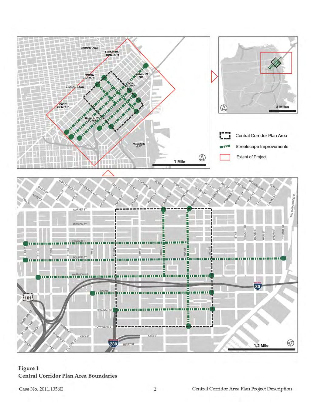
1 Project Description A. Overview The Planning Department ( Department ) is proposing to rezone the area of San Francisco around the southern portion of the Central Subway transit line in order to increase the amount of allowable development and to specifically allow for more job growth. The Department will prepare an Environmental Impact Report (EIR) in compliance with the California Environmental Quality Act (CEQA) that analyzes the environmental effects of the proposals in the Central Corridor Plan (referred to hereinafter as the Plan ), drafted by the Department and published in April The Plan area is located within the South of Market (SoMa) neighborhood and encompasses approximately 260 acres that are bounded by Market Street to the north, Sixth Street to the west, Second Street to the east, and Townsend Street to the south (see Figure 1 on page 2). The project analyzed in the EIR also includes street network changes throughout the Plan area, including specific designs within, and in some cases extending beyond, the Plan area for the following streets: Folsom, Howard, Harrison, Bryant, Brannan, Third, and Fourth streets (see Figure 1 on page 2). The Plan seeks to accommodate growth primarily by: (1) removing land use restrictions to support a greater mix of uses while also emphasizing office uses in the central portion of the Plan area; (2) increasing height limits on certain sites, primarily south of Harrison Street; and (3) modifying the system of streets and circulation to meet the needs and goals of a dense transitoriented district. The Plan identifies two height options a Mid-Rise Option (Option A) and a High-Rise Option (Option B). In general, Option A would increase heights along Fourth, Harrison, and Bryant streets from 65 feet to 85 feet. Option A would also allow for towers between 130 and 320 feet on certain sites, mostly located south of Harrison Street, increasing height limits on those sites by 45 to 235 feet. Option B would be similar to Option A, except that Option B would increase tower height limits for certain sites south of Harrison Street to between 115 and 400 feet, increasing height limits on those sites by about 60 to 315 feet. The EIR will also analyze a land use variant that would prohibit residential uses in a four-block area bounded by Bryant, Townsend, Fourth and Sixth streets. Additionally, the Plan proposes other public realm improvements, the provision of open space, and policies to preserve neighborhood character, historic structures, improve public amenities and promote sustainability. Case No E 1 Central Corridor Plan Area Project Description
2
3 The Plan also includes financial programs to support the Plan s public improvements, through the implementation of one or more new fees, as well as possible taxes or assessments that would be applied to new development. The proposed Plan would result in a comprehensive plan and implementing mechanisms, including General Plan, Planning Code and Zoning Map amendments, as necessary. The Department will prepare a program-level EIR for the Central Corridor Plan, and will include a project-level analysis of proposed street network changes, such that these improvements may be considered for adoption based on this EIR. Pursuant to CEQA Guidelines Section 15168, a program EIR may be prepared for a series of actions that can be characterized as one large project, related, as in this case, geographically; as logical parts in a chain of contemplated actions; and in connection with the issuance of rules, regulations, plans and other general criteria to govern the conduct of a continuing program. B. Project Objectives The project sponsor for the Central Corridor Plan is the San Francisco Planning Department. Through the Plan, the Department seeks to accommodate job and housing growth in close proximity to local and regional transit. Key objectives of the Plan are to increase development capacity, increase density, consider the future of parcels that currently retain industrial designations, and improve the physical, social and environmental surroundings. Critical to supporting that increased development capacity is a robust public realm and a substantial transformation of key streets to support transit, walking and biking. B.1. Plan Area Objectives The Plan sets forth five overriding goals: 1. Support transit-oriented growth, particularly workplace growth, in the Central Corridor area. 2. Shape the Central Corridor s urban form recognizing both City and neighborhood contexts. 3. Maintain the Central Corridor s vibrant economic and physical diversity. 4. Support growth with improved streets, additional open space, and other elements of complete communities. Case No E 3 Central Corridor Plan Area Project Description
4 5. Create a model of sustainable growth. B.2. Street Network Objectives Building upon Plan Objective #4 (Support growth with improved streets), the Plan sets forth more detailed principles and goals for proposed street network improvements: 1. Provide a safe, convenient and attractive walking environment on all streets in the Plan area. 2. Configure transit routes to adequately serve the area and redesign streets that serve transit to lessen the impact of traffic on transit performance. 3. Make cycling an attractive transportation option throughout the Plan area for all ages and abilities. 4. Employ Transportation Demand Management measures to encourage mode-shift away from private automobile usage. 5. Accommodate regional and through traffic on a limited number of streets where necessary, but reduce the impacts of such traffic on local livability and circulation. C. Background The desire for a Central Corridor Plan began during the Eastern Neighborhoods planning process. In 2008 the City adopted the Eastern Neighborhoods Plan including new land use controls and proposed community improvements for industrially zoned land in the City s southeastern area. Due to the pending development of the Central Subway transit project, the Planning Department decided to defer the rezoning of a swath of land along the Central Subway the Service Light Industrial (SLI) use district. Instead, the Eastern Neighborhoods Plans recommended that area be addressed in a separate, focused planning process that took into account the City s growth needs as well as the transportation opportunity represented by the Central Subway. Since then the City s growth needs have become much clearer. The adoption of Senate Bill 375, which required regions to prepare a Sustainable Communities Strategy (or Alternative Planning Strategy) to reduce greenhouse gas emissions (GHGs) by linking growth to transit, resulted in higher jobs and housing growth projections. Plan Bay Area, the Bay Area s draft Sustainable Communities Strategy, developed jointly by the Association of Bay Area Governments (ABAG) Case No E 4 Central Corridor Plan Area Project Description
5 and the Metropolitan Transportation Commission (MTC), projects about 92,400 additional housing units and 191,000 additional jobs for San Francisco by 2040, compared to existing conditions and represents roughly 15 percent of the regions total growth. These figures also represent a 25 percent increase in the number of housing units and a 34 percent increase in employment within San Francisco as compared to existing conditions. ABAG and MTC expect this growth to be planned in high density, transit-served locations. While the City has planned for new housing, resulting in estimated capacity for over 75,000 new housing units, it has been less proactive in planning space for jobs. With substantial development occurring since the adoption of the Downtown Plan 20 years ago, relatively few Downtown building sites remain to support continued job growth. Remaining space in Mission Bay, and new space added in the Transit Center District Plan area, will not be sufficient to meet growth needs, as projected by Plan Bay Area. Current low vacancy rates and high rents in SoMa indicate an area of high demand, and it is anticipated that companies in the information technology and digital media industries will increasingly seek to locate in this area, due to its central location, transit accessibility, urban amenities and proximity to San Francisco s well educated workforce. The Planning Department initiated the Central Corridor Planning Process in earnest in early 2011 with funding from the California Department of Transportation (Caltrans) and the San Francisco Municipal Transportation Agency (SFMTA). In developing the draft Plan, the Department prepared two background documents: (1) the Central Corridor Background Report published in April 2011, 1 and (2) the Public Realm Existing Conditions Report published in October Throughout the process, the Department met with a range of community groups, and involved City and regional agencies as part of the Plan s Technical Advisory Committee (TAC). Working with stakeholders through a public process, including walking tours, a storefront charette, a 1 The Central Corridor Background Report is available for review online: Accessed March The Public Realm Existing Conditions Report is available for review online: Accessed March Case No E 5 Central Corridor Plan Area Project Description
6 print and web-format survey, an interactive website, and a series of community workshops, 3 the Planning Department developed the Central Corridor Plan which includes strategies and recommendations to coordinate transit supportive land uses with public realm improvements. D. Project Location As shown in Figure 1 on page 2, the Plan area is located along the southern portion of the Central Subway transit line, and is bounded by Market Street to the north, Sixth Street to the west, Second Street to the east, and Townsend Street to the south. Altogether, the Plan area comprises approximately 260 acres and is bordered by the Transbay, Rincon Hill, Mission Bay and Downtown neighborhoods. It includes portions of the former Yerba Buena Redevelopment Plan Area, and the East and Western SoMa Plan Areas. This Plan area, plus streetscape changes extending from The Embarcadero to Eleventh streets along Folsom Street; Third to Eleventh streets along Howard Street; Second to Tenth streets along Harrison Street; from Second to Seventh streets along Bryant Street; from Market Street to Harrison Street along Fourth Street; and from Market Street to King Street along Third Street, represents the designated project area for this EIR. E. Project Components The EIR will analyze physical environmental impacts of the proposed Plan and associated street network changes. For some policy issues, the EIR will analyze options to those policy decisions in order for decision makers and the public to compare the environmental impacts of each option. Specifically, the EIR will analyze the Plan s proposed land use and a land use variant that would restrict new residential uses within a four block area bounded by Bryant, Townsend, Fourth and Sixth streets. The EIR will also analyze the environmental impacts associated with two proposed height options (Option A and Option B) and proposed street network improvements on Folsom, Howard, Bryant, Brannan, Harrison, Third and Fourth streets. The EIR will also analyze two options for the operation of Folsom and Howard streets as described on page 32. Street network improvements will be analyzed in sufficient detail to allow for project-level CEQA clearance. 3 A comprehensive overview of the Plan s public engagement process can be found in the Plan s Appendices, and is summarized online: Case No E 6 Central Corridor Plan Area Project Description
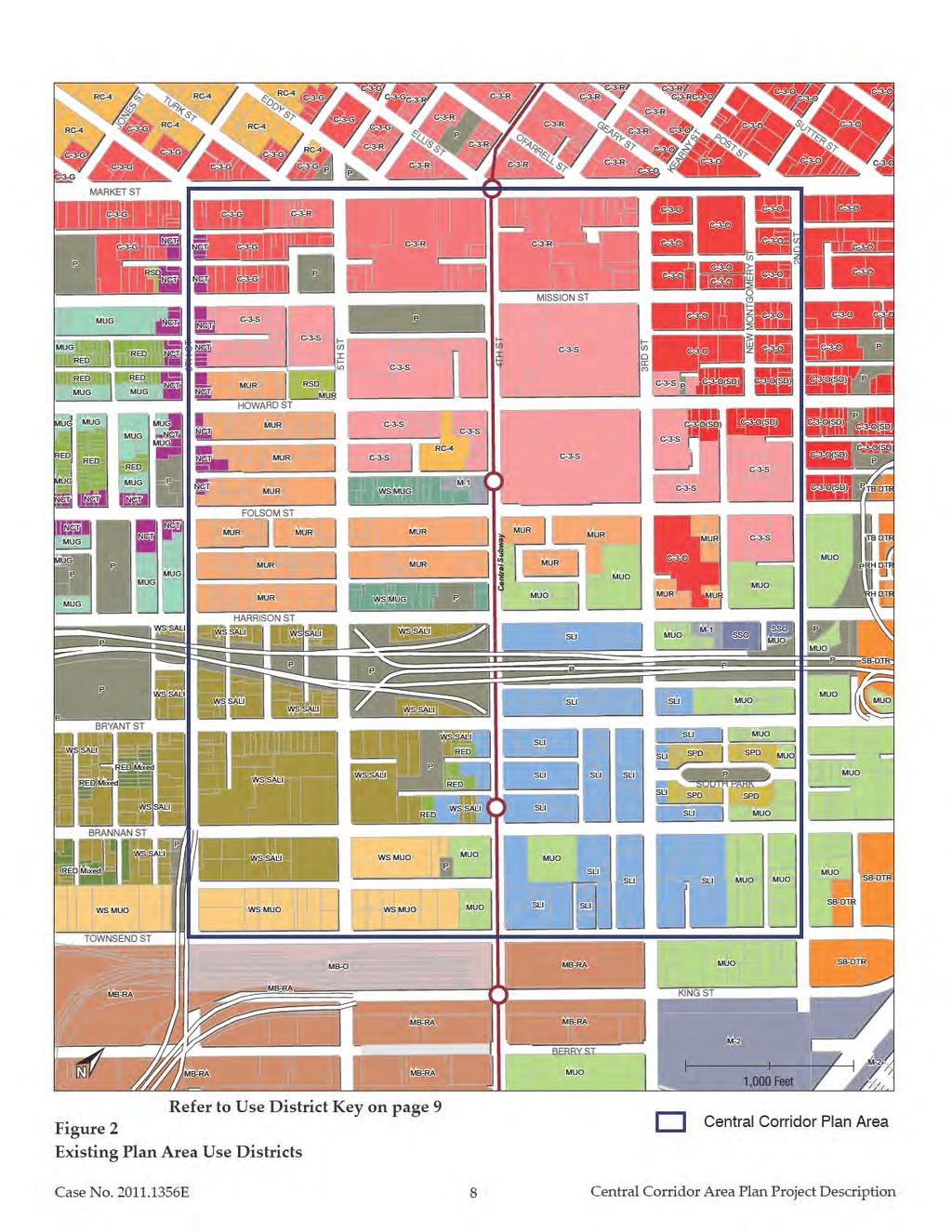
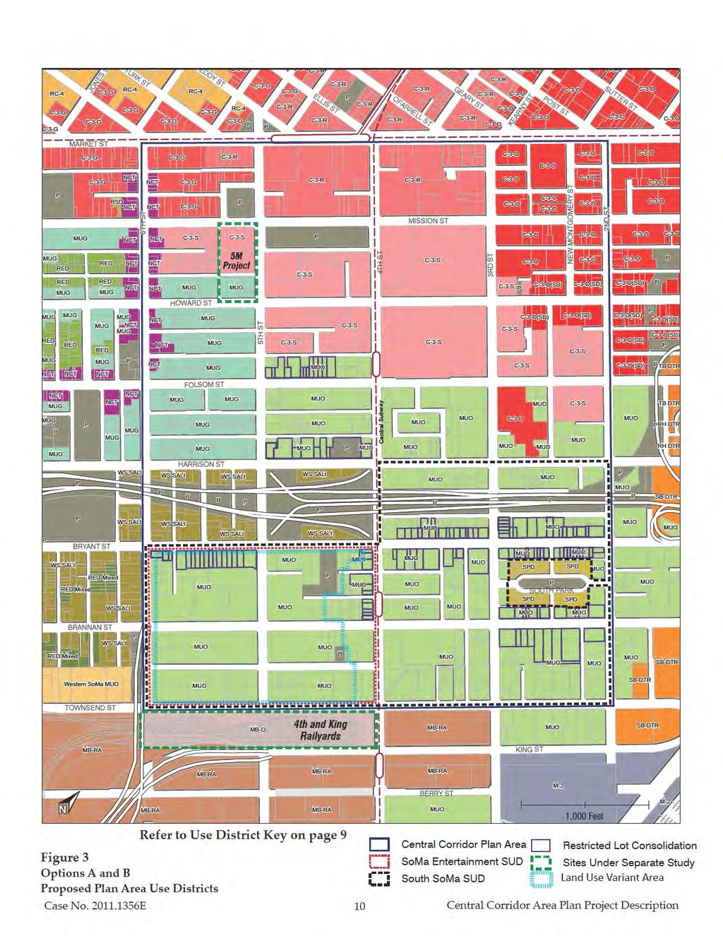
7 E.1. Land Use Land uses within the Plan area are mixed and are characterized primarily by office, production, distribution and repair ( PDR or generally, light industrial) and retail uses. The northern end of the Central Corridor Plan area features a number of large parcels with a concentration of higher density residential uses, including a substantial number of senior and affordable housing developments, as well as regionally important museums, and visitor and cultural facilities (e.g., Moscone Convention Center, Yerba Buena Center for the Arts, San Francisco Museum of Modern Art, Contemporary Jewish Museum). The Plan s southern end primarily features office, PDR, retail, and entertainment uses, as well as several surface parking lots. The existing use districts in the Plan area are shown in Figure 2 on page 8 (with an accompanying key in Table 1, on page 9). The northern portion of the Central Corridor Plan area maintains a strong relationship to Downtown, reflected by the Downtown Commercial (C 3) and Mixed Use Office (MUO) use districts that support high density office and residential uses with higher height limits (120 feet or greater). Much of this area was formerly part of the Yerba Buena Redevelopment Area. A swath of land ringing this area north of the freeway is currently zoned primarily for housing, designated Mixed Use Residential (MUR), Residential Service District (RSD), and Residential Enclave District (RED). The SLI zone predominates south of Harrison Street. The SLI use district neither permits new housing, except deed restricted affordable housing, nor office uses, except in historic buildings. These use restrictions have effectively preserved this area with low scale (one to two story) low density commercial uses. The Plan s land use strategy seeks to accommodate transit-oriented growth while preserving and enhancing the Plan area s mix of uses (office, hotel, entertainment, industrial, retail, cultural and residential) and building types (lower-scaled development predominates in the southern portion of the Plan area with larger-scale development in the northern portion of the plan area). In general, proposed land use changes would remove land use restrictions (such as allowing residential uses in areas where this use is limited or allowed only with certain restrictions) to support a greater mix of uses while also emphasizing office uses in the central portion of the Plan area (as shown by the MUO designation). The Plan would result in the following land use changes described below and shown in Figure 3 on page 10. Case No E 7 Central Corridor Plan Area Project Description
8
9 TABLE 1. PLANNING CODE USE DISTRICT KEY Use District Code Use District C-3-G Downtown Commercial, General C-3-O Downtown Commercial, Office C-3-R Downtown Commercial, Retail M-1 Light Industrial M-2 Heavy Industrial MB-O Mission Bay Office MB-RA Mission Bay Redevelopment Area MUG Mixed Use, General MUO Mixed Use, Office MUR Mixed Use, Residential NCT Neighborhood Commercial Transit P Public RC-4 Residential Commercial, High Density RED Residential Enclave District RSD Residential/Service Mixed Use District SLI Service/Light Industrial SPD South Park District SSO Service Secondary Office TB-DTR Transbay Downtown Residential WS-MUG West SoMa Mixed Use General WS-MUO West SoMa Mixed Use Office WS-SALI West SoMa Service, Arts, Light Industrial Source: San Francisco Planning Code. The Residential Commercial, High Density (RC-4) zoning district would be converted to Downtown Commercial Support (C-3-S). Within the Plan area there is one parcel on the block bounded by Fourth, Fifth, Howard and Folsom streets zoned RC-4. The Plan proposes to rezone this area to C-3-S, consistent with the surrounding zoning district. Community facilities and commercial uses generally permitted in the C-3-S zoning district are either restricted by Conditional Use or not permitted in the RC-4 district. Changing this zoning district to C-3-S would allow for a greater mix of uses (including hotels, museums and cultural facilities, housing, retail, and offices) that are similar to this district s surroundings. The MUR and RSD zoning districts would be converted to a Mixed-Use General (MUG) zoning districts in the area bounded by Mission, Harrison, Fifth and Sixth streets. The MUR and RSD zoning districts require a ratio of three square feet of housing for every square foot of other uses. The MUG zoning designation would remove this restriction and allow for greater flexibility in the mix of land uses, including limited office development as well as new all-commercial buildings. Case No E 9 Central Corridor Plan Area Project Description
10
11 The Western SoMa Mixed-Use General (WS-MUG), Light Industrial (M-1), and MUR zoning districts would be converted to MUO in the area bounded by Howard, Fifth, Harrison, and Fourth streets as well as the blocks bounded by Folsom, Fourth, Harrison and Second streets. A primary goal of the Plan is to accommodate job growth and these existing zoning districts either do not permit or limit office uses, whereas the MUO zoning designation would support a greater amount of job growth. South of Harrison Street, as shown in Figure 3, existing use districts would all be converted to an MUO zoning district; except for parcels currently designated SPD and the WS-SALI area west of Fourth Street north of Bryant Street which would retain their current zoning designations. Zoning districts in this area that would be converted to MUO include the Western SoMa Service, Arts, Light Industrial (WS-SALI), WS-MUO, RED, SLI, M-1, and Service Secondary Office (SSO) use districts. These existing use districts either limit or restrict office uses, or when office uses are allowed, other uses, such as entertainment or residential uses are restricted. For example, the RED use district permits housing as a principle use but requires Conditional Use authorization for most other uses. Converting these zoning districts to MUO would accommodate a mix of land uses that allow for greater flexibility as the MUO district generally allows office, residential, and most other uses without limitation. However, the Plan also proposes that most of this area also be included in a new South SoMa Special Use District that would require primarily commercial space on large parcels (e.g. greater than 20,000 square feet) to emphasize space for jobs. Proposed zoning changes are supported by the Plan s four land use principles and corresponding implementation strategies, discussed below. The Plan includes other implementation strategies that are not cited below; however those strategies would not result in direct or indirect physical environmental impacts (e.g., strategies that call for additional studies or continued implementation of existing controls within the Plan area- such as rent stabilization, eviction protections, and restrictions on unit demolition or mergers). 1. Support substantial development in the Central Corridor Plan area. In order to support substantial development in the Central Corridor, the Plan proposes the following strategies: Maintain growth oriented zoning where it exists. The Plan would not change existing zoning in the C-3 use districts. Much of the plan area is already zoned for density, Case No E 11 Central Corridor Plan Area Project Description
12 particularly the area north of Harrison. The MUO zoning district in the southeast of the Plan area would be retained and the WS MUO zoning district, which does not permit residential uses, would be changed to MUO to allow such uses. Rezone the SLI use district and the WS-SALI use district enacted under the Western SoMa Plan (covering much of the Plan area south of Harrison Street), which does not permit residential or office uses but does allow for industrial and arts activities, to MUO a use district that permits a broad range of uses from office uses and housing to small-scale light industrial and arts activities. Allow physical controls for height, bulk, setbacks, and open space to determine density. In much of San Francisco development density is not tied to height or other physical controls, often resulting in developments that do not reach their full development potential. For commercial uses, the amount of allowable development (Floor Area Ratio, or FAR ) would be correlated with allowable heights and bulk. For residential development, the Plan would eliminate FAR as a control on density and instead allow height, bulk, setbacks, etc., govern residential density, consistent with other recently adopted area plans; all major residential development would also be required to meet a minimum percentage of larger, family units. 2. Favor commercial development over other kinds of growth. The Plan proposes the following to favor commercial development over other kinds of growth: Require commercial development on large parcels. The Plan proposes a South SoMa Special Use District (SUD), as illustrated in Figure 3 on page 10. The South SoMa SUD would require predominantly commercial development on large parcels to ensure that these parcels would be available for large floor plate commercial development. The exact mechanism utilized to require commercial development in this area would be developed as part of the zoning proposal for the Plan. Potential mechanisms could include a requirement for a minimum percentage (e.g. 50 percent) of new square footage to be commercial on all parcels over 20,000 square feet, or limiting the amount of residential development on these larger parcels. Rezone the MUR zoning district to enable workplace development as well as a more diverse set of uses (such as hotel and entertainment uses). As discussed above, the MUR zoning district s requirements preclude development of new all-commercial buildings. West of Fifth Street, where the area is typically more residential and fine-grained, the Case No E 12 Central Corridor Plan Area Project Description
13 Plan proposes to rezone the MUR to MUG, a use district in which some office and retail development is allowed, but development is still expected to retain its predominantly residential character. East of Fifth Street, in the area that is already more jobs-oriented, the Plan proposes to rezone the MUR to an MUO zoning district, emphasizing office uses over other types of land use. 3. Support development of a diversity of housing especially below-market rate units. While jobs are the primary focus of the draft Central Corridor Plan, housing is also an important component, particularly for creating a vibrant, 24-hour district. To support development of a diversity of housing, especially below-market rate units, and to create a 24- hour district the Plan would: Maintain residential zoning for those areas that are already primarily residential. Mixeduse zoning that permits housing in the Plan area will be maintained, enabling new residential uses. Remove restrictive zoning in areas that can support additional housing. As noted above, the Plan proposes to rezone the SLI and SALI zoning districts to MUO, which permits housing in addition to commercial uses. Require larger, family-oriented units; new development in mixed-use districts would be required to provide at least 40 percent two-bedroom units or 30 percent three-bedroom units. Require increased levels of affordable housing in zoning districts where housing was not previously permitted (except for deed-restricted affordable housing and by Conditional Use only). The Plan proposes to increase inclusionary requirements in areas proposed to be rezoned from SLI, SALI (which currently do not permit housing) or M (which permits housing conditionally) to MUO or other districts that permit housing. For example the City s current requirement is for 12 percent of the units in new housing developments to be below market rate (i.e., for people earning up to 120 percent of the Area Medium Income or AMI ) if provided onsite, or 20 percent if provided off-site or through in-lieu fee payments. As in the Eastern Neighborhoods, former SLI, SALI and M parcels that are rezoned to allow residential uses would be required to provide increased affordable housing above these levels. The Plan may also consider increasing that amount in areas that receive a substantial increase in residential development potential through a greater increase in height limits. Case No E 13 Central Corridor Plan Area Project Description
14 5. Reinforce SoMa s mixed-use character by permitting a diversity of land uses. In order to support and enhance the Plan area s vibrancy and identify, the Plan proposes to allow a wide range of uses while minimizing conflicts between those uses. Specifically, the Plan proposes to: Permit PDR uses. PDR would continue to be widely permitted throughout the Plan area. While much of the existing use districts such as SLI, WS-SALI, WS-MUO, and M-1 permit PDR uses, the RED zoning district does not permit PDR uses. The Plan would rezone the RED zoning district MUO, thereby allowing PDR uses in areas where it is currently not permitted. Permit retail, but not stand-alone big box retail throughout the Plan area. Permit and support community facilities such as schools, child care, community centers, and public services (like police and fire) throughout the Plan area. Permit entertainment uses where appropriate. The Plan proposes to limit new entertainment uses to an area south of Harrison Street between Fourth and Sixth Streets, via the SoMa Entertainment SUD illustrated in Figure 3 on page 10. Land Use Variant Within the Central Corridor west of Fourth Street, in the area roughly bounded by Bryant, Townsend, Fourth and Sixth Streets, the WS-SALI and WS-MUO zoning districts applied as part of the Western SoMa Plan currently do not permit new housing. The Plan proposes to rezone the majority of those zoning districts to permit housing and thereby enable a lively 24- hour neighborhood. However, there is community concern that any allowance for new housing in this area could impinge upon existing and future commercial uses (particularly on smaller lots) and could create conflicts with potential new entertainment uses that would also be permitted in this area. The Land Use Variant will study the ramifications of maintaining a restriction on new housing in the area roughly bounded by Bryant, Townsend, Fourth and Sixth streets that are currently zoned WS-SALI and WS-MUO (see Figure 3 on page 10). E.2. Urban Form Building heights in the Plan area vary considerably, ranging from single story buildings to buildings of 20 stories or more. While the area s typical building height is considerably less than building heights in the Financial District to the north, its density of uses is substantially higher than those parts of the City further from downtown. Case No E 14 Central Corridor Plan Area Project Description
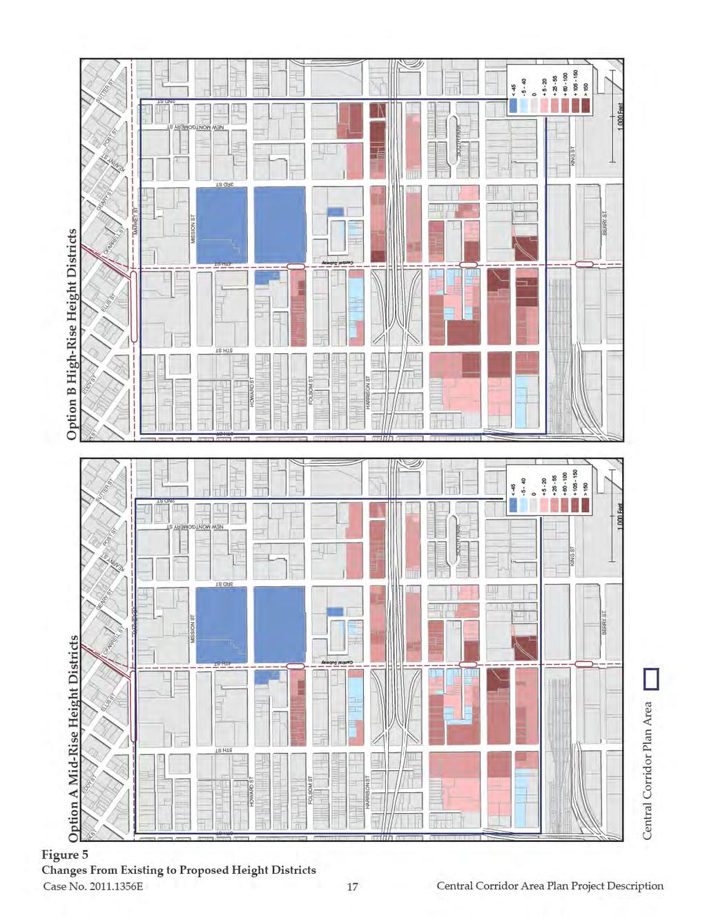
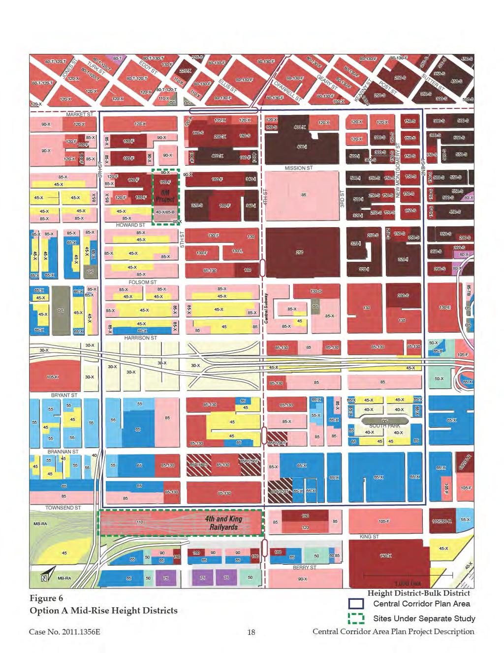
15 Existing height districts are shown in Figure 4, on page 16. Permitted heights in the northern portion of the Plan area are highest around Mission Street, reflecting the southern extent of Downtown s high rise core. Height districts step down in the central portion of the Plan area to between 85 and 130 feet. Current residential zoning districts, including the MUR, RED, and RSD districts in the northern portion of the Plan area, mostly allow buildings up to 85 feet or 8 stories (though up to 120 feet are allowed in some places), with requirements for further height sculpting on alleys. On some block frontages where heights are permitted up to 85 feet, heights are limited on interior block frontages to 45 feet. Building heights within the southern portion of the Plan area, generally south of Bryant Street, are within the 50 to 85 foot range. Permitted heights in the SLI use district are lower than other portions of the Plan area and are typically 40 to 85 feet. The Central Corridor Plan seeks to increase opportunities for growth through changes to height and density that are respectful of not only the City s skyline, but of local character and pattern. The Plan contains four high-level objectives: (1) Enhance the city skyline in harmony with, and being respectful of, the city pattern, including views across SoMa to and from the hills, Bay, and downtown; (2) Base height limits 4 should be reflective of the width of adjacent streets; (3) The Fourth Street corridor and rail stations should be reinforced by additional height; and (4) the greatest heights should be focused at the north and south, in proximity to regional transit. These high-level objectives are further articulated by several detailed principles related specifically to height, resulting in a Mid-Rise Height Option (Option A) and a High-Rise Height Option (Option B), as described below. Figure 5 on page 17, shows the change in height limits as compared to existing height limits for Options A and B. Mid-Rise Height Option (Option A) Height limits proposed under the Mid-Rise Height Option (Option A) are shown in Figure 6, on page 18. In general, Option A would increase heights along Fourth, Harrison, and Bryant streets from 65 feet to 85 feet. 4 The base height of a building is the maximum permitted height of the front wall of a building before any required setback. A building is required to meet a minimum base height only when the height of the building will exceed the maximum base height. Case No E 15 Central Corridor Plan Area Project Description

16
17
18
19 This option would also allow for towers between 130 and 320 feet on certain sites, mostly located south of Harrison Street, increasing height limits on those sites by 45 to 235 feet. Proposed height changes under this option are supported by the following principles. 1. Heights should be sculpted in a manner mindful of views through and across the area from surrounding areas with views of the Bay, East Bay hills, and other key features. The Plan s urban form proposals intend to build on and reinforce existing patterns in SoMa. Height proposals in the Plan are based on a broad three-dimensional consideration of the placement and scale of buildings and potential development sites. 2. The predominant character of SoMa as a mid-rise district should be retained, and the presence of high-rises reduced by limiting their distribution to transit stations. In order to preserve the character of the Plan area and views across it, height limits taller than 130 feet are generally kept to the southern portion of the Plan area (Brannan Street southward), limited in distribution and widely spaced. Also, bulk limits would restrict floor plate sizes, and these bulk requirements would be supported by tower separation requirements. Adjacent towers would be required to vary in height (e.g. by 50 feet or more). 3. Addition of substantial new shading should be avoided on public open spaces to the extent feasible, balanced with other core objectives. To accomplish this, the height limits proposed in Option A have been sculpted to avoid additional shading to South Park beyond shadow that could occur with build out of existing height limits. Height limits are also intended to protect sunlight on Yerba Buena Gardens, Lapu Lapu Community Garden, the Bessie Carmichael School Yard, and, insofar as is feasible, a potential park site identified in the Plan and discussed further below, on the block bounded by Fourth, Fifth, Bryant, and Brannan streets (Assessor s Block 3777). 4. Building height limits should be adjusted in areas with a high concentration of historic buildings and unique character. To accomplish this, Option A does not propose to increase height limits in the South Park block and the western portion of the South End Historic District. Option A would reduce the height limit on the west side of Fourth Street between Bryant and Brannan streets from 65 feet to 45 feet, as this stretch contains one of the few cohesive blocks of small-scale neighborhood retail in the Plan area. Option A also requires sculpting and upper story setbacks along narrow streets as per Planning Code Section 261.1; and requires a minimum 10 foot setback above certain heights, Case No E 19 Central Corridor Plan Area Project Description
20 as well as preservation of a 45-degree sun plane on the southern side of east-west streets. In areas where proposed height limits are 85 feet or higher, particularly in the area bounded by Bryant, Brannan, Fourth and Sixth street in the southwestern part of the Plan area, the sun angle requirement would be relaxed to instead require a minimum 10-foot setback similar to the north side of the street. 5. Height limits should be appropriate for the central city location and transit access and serve to diminish the dominant presence of the freeway in the neighborhood. To accomplish this, the Plan proposes a base height limit of 85 feet along the freeway in areas east of Fourth Street. 6. The diverse scale of buildings in the Plan area should be maintained, particularly areas with a fine grain concentration of smaller lots and buildings. The Plan seeks to accomplish this through the following implementation strategies: To preserve the few areas that maintain a pattern of small lots and buildings, the Plan would require Conditional Use authorization where a lot frontage greater than 100 feet would be created by the consolidation of two or more parcels that each have 50 feet or less in lot frontage. These areas exist along Folsom Street between Fourth and Fifth streets, Harrison Street between Fourth and Fifth streets, Bryant Street, and Brannan Street between Third and Fourth streets. Encourage maintenance of older buildings and allow substantial additions to them, through Design Guidelines, incentives, and other mechanisms such as: (1) a FAR bonus for the preservation of existing buildings through additions rather than demolition; and (2) higher FAR allowances for smaller lots than larger ones. 7. Reduce the scale of large blocks and parcels. The Plan seeks to ameliorate the pattern of large blocks and parcels through the following implementation strategies: The requirements of Planning Code Section 270.2, requiring new developments on large parcels on long blocks to include new publicly accessible mid-block alleys, now apply throughout mixed-use and C-3 zoning district and would be extended throughout the Central Corridor Plan area. Case No E 20 Central Corridor Plan Area Project Description
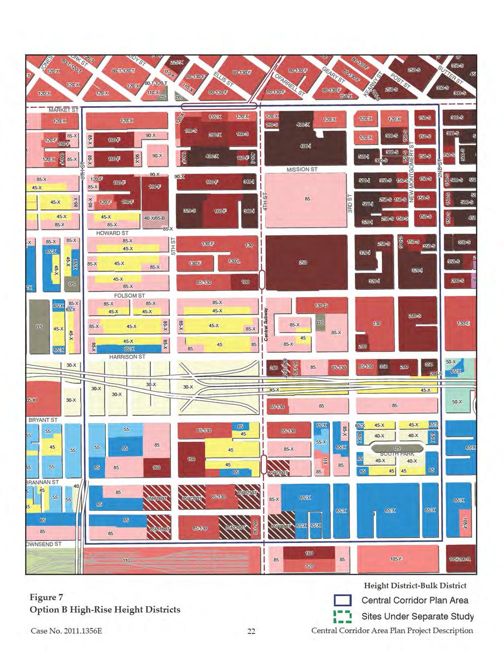
21 Final zoning recommendations would include a set of guidelines for key development sites, highlighting desired locations for public open space, mid-block alleys, generalized building massing, vehicular access, and other key factors. These sites include: o Assessor s Block 3777 (Bryant/Fourth/Brannan/Fifth streets). o Parcels adjacent to the new Central Subway stations, particularly at the corners of Fourth Street at Folsom and Brannan streets o Parcels near the intersection of Fourth and Townsend streets, adjacent to and across from the Caltrain station o The Flower Mart/Assessor s Block 3778 High-Rise Height Option (Option B) This option includes the Plan s policies as presented in Option A, with changes to Urban Form principles to reflect higher height limits as shown in Figure 7 on page 22. (Figure 5, above, depicts the proposed change in heights from existing height limits to those proposed under Option B.) The key difference in this scenario compared to Option A is that height and bulk districts would be amended to allow taller and larger buildings at a limited number of locations, primarily adjacent to, and south of, the elevated I-80 freeway, than are considered under Option A. These height districts are based on the High-Rise Height Alternative contained in the draft Central Corridor Plan released April 2013 and modified to include further height increases on certain sites. Option B maintains the same urban form principles and implementation strategies as Option A; however these options differ as follows: In Option B, heights taller than 130 feet are expanded to more locations south of the freeway along and near Fifth Street, including sites between Bryant and Brannan streets, at Fifth and Brannan streets, and at Fifth and Townsend streets; and one site midblock along Townsend Street between Fifth and Fourth streets. They are also expanded to three sites north of the freeway, at Fourth and Harrison, Third and Harrison, and Second and Harrison streets. Additionally, two sites designated for heights taller than 130 feet proposed in Option A, at Fifth and Brannan and Fourth and Townsend, have been increased to higher tower limits in Option B. Finally, heights along Brannan Street midblock between Fifth and Sixth streets are increased slightly beyond the heights proposed in Option A, to 85 feet in Option B. Case No E 21 Central Corridor Plan Area Project Description
22
23 Height limits on the block bounded by Fourth, Fifth, Bryant, and Brannan streets (Block 3777) are sculpted to feature the tallest heights of 160 feet to the west of the proposed park site, while keeping the heights due south of the park site relatively lower at 130 feet to maintain some sunlight benefits during certain times of the year. E.3. Circulation and Streetscape Improvements The Plan area contains a diverse network of public transportation options, including: (1) the Bay Area Rapid Transit (BART) and Caltrain regional rail lines, (2) the Transbay Transit Center (both the temporary terminal at Beale and Howard streets and the permanent terminal under construction at First and Mission streets), which connects the Plan area to much of the East Bay (via Alameda-Contra Costa County Transit District (AC Transit) and Western Contra Costa Transit Authority (WestCAT), Marin County (via Golden Gate Transit), and San Mateo County (via SamTrans); (3) the MUNI Metro light rail network; and (4) MUNI local bus service, which directly serves the entire Plan area via bus lines such as the 10, 12, 14, 27, 30, 45, and 47. The Plan area is also well served by the freeway system, including I 80, which bisects the Central Corridor Plan area into northern and southern portions and I 280, which feeds the south side of the Plan area. A network of wide surface streets provides vehicular circulation within the Plan area. As a result of the City s original 1847 O Farrell survey, major streets in the Central Corridor Plan area and in SoMa in general are 82.5 feet wide, compared to 50 to 70 feet in width for most streets north of Market Street and 70 to 80 feet for most streets in the western residential neighborhoods; blocks within the Plan area are larger than elsewhere in the City. Major northsouth streets 5 (numbered) are typically 825 feet apart, while major east-west streets (named) are 550 feet apart. These major streets form large SoMa blocks of approximately 10.5 acres each. These blocks are usually subdivided into three long, narrow blocks by two minor 35 foot wide east-west streets. As a result of development, many minor streets that were originally through streets now dead-end in the interior of their large SoMa block. 5 Streets in SoMa are generally parallel or orthogonal to Market Street, which is oriented at approximately 44 degrees off true north. However, streets parallel to Market Street are generally described as east-west streets, while streets orthogonal to Market Street are generally described as running north-south. Case No E 23 Central Corridor Plan Area Project Description
24 Sidewalks are typically narrow most are less than the 15 feet common elsewhere in San Francisco, and many are 10 feet or less with the vast majority of the public right-of-way devoted to automobiles. Usually there are between four and five auto lanes traveling in one direction, more than in other San Francisco neighborhoods, with curb-side parking on both sides. Street trees, which are generally young and thus relatively small, help to soften the cardominated streetscape, but they often narrow the already under-sized pedestrian path of travel. Intersections of major streets are signalized and have marked crosswalks on all sides; intersections of major streets with minor streets are usually not signalized and do not have any marked crosswalks. With signalized crossings almost exclusively located at the intersections of major streets, there are relatively fewer locations at which to safely cross major east-west streets than in other neighborhoods. The Plan area s relatively high density is supportive of walking; although its wide, predominately one way streets, long blocks, few amenities, and presence of an elevated freeway and associated ramps generally do not contribute to a positive pedestrian experience and presents many physical challenges for pedestrian circulation in the area. Bicycle lanes within the Plan area exist on Howard, Folsom, and Townsend streets; and the San Francisco Bicycle Plan designates additional lanes on Second and Fifth streets. 6 Several projects are either in progress or proposed to improve the transportation network within the Plan area. The most important is the Central Subway, expected to be operational by The Central Subway is anticipated to move 76,000 daily riders through the Plan area by 2030, with a peak hourly capacity of almost 5,000 riders in each direction. Stations will include new underground facilities in Chinatown, at Union Square/Market Street, and at Moscone Center, with above ground stations at the intersections of Fourth/Brannan and Fourth/King streets. Additional transportation improvements include: the planned but not-yet-funded Caltrain Downtown Extension which, when complete, will extend Caltrain along the eastern Plan area boundary through a tunnel beneath Second Street to the Transbay Transit Center near First and Mission streets; improvements to MUNI made through the TEP; anticipated improvements to the bicycle network from implementation of the Bicycle Plan; and streetscape 6 The San Francisco Bicycle Plan is available for review online: Accessed March Case No E 24 Central Corridor Plan Area Project Description
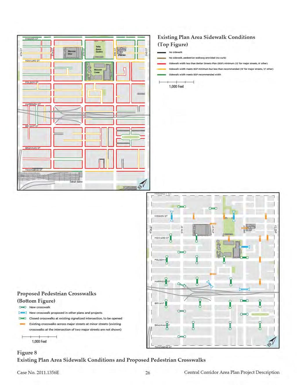
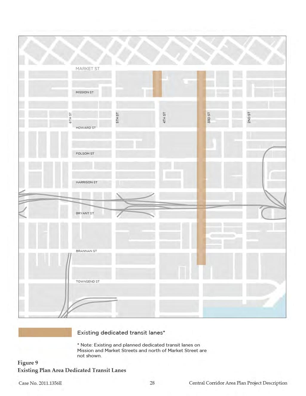
25 improvements under the Transit Center District Plan, Rincon Hill Plan, and East and Western SoMa Plans intended to improve walkability in SoMa. The land use changes proposed in the Plan are expected to increase demand for travel in the Plan area, while safe and convenient pedestrian, transit and bicycle access to and within the Central Corridor Plan area is necessary for the success of the envisioned land uses. The Plan includes the following proposals to improve pedestrian, transit and cycling conditions on major streets in the Plan area: 1. Provide a safe, convenient and attractive walking environment. As a major convention and tourism destination, employment center, and residential area, the Central Corridor Plan area attracts thousands of people daily, the overwhelming majority of whom will either begin or end their trip as pedestrians. Creating a complete, high quality walking network is necessary to make all aspects of the transportation system function well. The Plan proposes the following: Upgrade sidewalks to meet the standards in the Better Streets Plan. Sidewalks should be widened to meet Better Streets Plan standards where possible, provide corner sidewalk extensions to enhance pedestrian safety at crosswalks, and add street trees and furnishing wherever possible. Existing sidewalk conditions are shown in Figure 8 on page 26. Provide additional midblock crosswalks across major streets. The Plan proposes new pedestrian crosswalks throughout the Plan area as shown in Figure 8. Several signalized intersections of major streets in the Plan area prohibit pedestrians from crossing one leg of the intersection. The Plan recommends certain locations to open currently closed crosswalks as shown on Figure Configure transit routes to adequately serve the Plan area and redesign streets that serve transit to lessen the impact of traffic on transit performance. The Plan proposes the following to prioritize transit: A network of dedicated transit lanes in order to enhance transit travel times and reliability. New dedicated transit lanes are proposed on Fourth, Harrison, Bryant, and Folsom streets. These are described further below in Street Network Changes beginning on page 31. Case No E 25 Central Corridor Plan Area Project Description
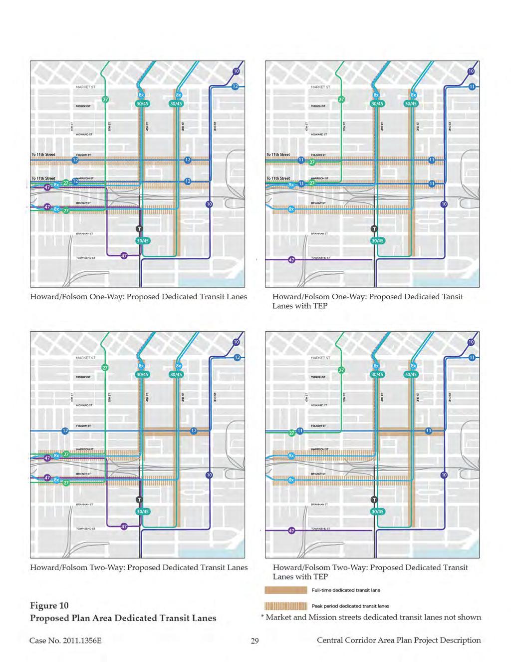
26
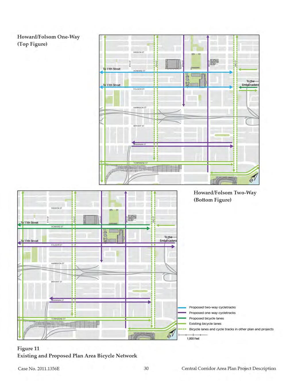
27 Upgrade existing and planned dedicated transit lanes with self-enforcing mechanisms such as curbs, channelizers and colored or textured pavements to discourage or prevent use by unauthorized private vehicles. In addition to the above proposals, the Plan calls for the continued evaluation of the transit network to ensure that it adequately serves evolving needs within the Plan area. Existing and proposed dedicated transit lanes are shown in Figures 9 and 10 on pages 28 and 29, respectively. The proposal for dedicated transit lanes vary depending upon whether Folsom and Howard streets are operated under a One-way or Two-way configuration (discussed further below) and would also vary with implementation of the TEP. Figure 10, on page 29, illustrates the proposed dedicated transit lanes under these various scenarios. 3. Make cycling an attractive transportation option throughout the Plan area for all ages and abilities. The Plan includes the following proposals to create a comprehensive network of safe and convenient bicycle routes, as well as destination amenities such as secure bicycle parking and shower facilities. The Plan proposes new or enhanced bicycle facilities on Folsom, Howard, Third, Fourth, and Brannan streets. Existing and proposed bicycle routes for Howard/Folsom One-way operation and Howard/Folsom Two-way operation (as discussed further below) are shown on Figure 11, on page 30. Protected bicycle lanes, known as cycle tracks, 7 offer safer and calmer cycling conditions for a much wider range of cyclists and cycling purposes, especially on streets with large traffic volumes traveling at relatively high speeds. Existing and planned bicycle routes should be upgraded to cycle tracks or equivalent facilities, where possible. 4. Employ Transportation Demand Management measures to encourage a mode-shift away from private automobile use. The City has successfully used Transportation Demand Management (TDM) tools in the downtown area to achieve high pedestrian, transit and bicycle mode shares. 7 A cycle track is a bike lane that is separated from vehicle traffic and parked cars by a buffer zone. Case No E 27 Central Corridor Plan Area Project Description
28
29
30
31 Large employers and commercial developments would be required to participate in a Travel Demand Association and any shuttle programs should be coordinated in the area to augment, rather than compete with public transit service. 5. Restrict curb cuts on key major streets to increase pedestrian comfort and safety, to provide a continuous building edge of ground floor uses, to provide continuous sidewalk for streetscape amenities, and to eliminate conflicts with transit, bicycles and general circulation. The Plan would prohibit new curb cuts on Mission, Folsom, Brannan, Townsend, Second, Third, Fourth and Sixth streets. New curb cuts would be subject to discretionary review (through a Conditional Use authorization) on Howard, Harrison, Bryant, and Fifth streets. E.4. Street Network Changes (Analyzed at a Project-Level) To implement the circulation and streetscape principles above, the proposed project includes a package of street network changes to support pedestrian and cycling modes and to lessen the impact of traffic on transit performance, while accommodating regional and through traffic on a limited number of streets where necessary. Proposals have been developed for Folsom, Howard, Third, Fourth, Harrison, Bryant, and Brannan streets, extending as far west as Eleventh Street (in the case of Howard and Folsom Streets) and east to The Embarcadero (Folsom Street only). (See Figure 1 on page 2.) The proposals for these streets include wider sidewalks, upgraded and/or new transit lanes, cycle tracks, and travel lane reductions, as described further below. The EIR will evaluate the environmental effects of the proposed street network changes at a project-level of detail to enable consideration of project approval following certification of the EIR. The street network changes described below represent major investments that in their full condition would happen gradually over time. Reconfigurations to street operations (such as conversion from one-way to two-way operation, installation of transit and bicycle facilities, and changes in the number of travel lanes) could be initially implemented on a street-by-street or block-by-block basis using roadway striping, traffic signal modifications, corner bulb-outs and other low-cost tools. However, sidewalk widening (and the removal of some on-street parking in order to widen sidewalks) is a substantial capital expense, and therefore sidewalk widening is expected to be implemented gradually over time. Subsequent developments would be required to widen sidewalks in front of their respective buildings. On blocks without development opportunity sites, sidewalk widening may need to be undertaken by the City as funding is available, and would have to compete with other transportation funding priorities. Case No E 31 Central Corridor Plan Area Project Description
32 The following describes the specific proposals Folsom, Howard, Third, Fourth, Harrison, Bryant, and Brannan streets. Howard/Folsom Two different options are being analyzed for the couplet of Howard Street and Folsom Street. Howard Street would be modified between Eleventh and Third streets, while Folsom Street would be modified between Eleventh Street and The Embarcadero. Under the One-Way Option, both streets would retain a one-way configuration (except Folsom Street east of Second Street which would retain its existing two-way operation). Under the Two-way Option, both streets would be converted into two-way operation, and some modifications to Harrison Street would also occur as described below. Currently, this section of Howard Street has four westbound travel lanes (three west of Sixth Street), a westbound bicycle lane, parallel parking along the north and south curbs, and 12 foot sidewalks. West of Second Street, Folsom Street has four eastbound travel lanes, an eastbound bicycle lane, parallel parking along the north and south curbs, and 10 foot sidewalks. Folsom Street east of Second Street is currently temporarily configured with a westbound transit lane to accommodate regional transit between the Temporary Transbay Terminal and the Bay Bridge. The current configuration changes block to block, but generally has two eastbound travel lanes and one transit-only westbound travel lane. One-way Option Under the One-way option, Howard Street between Eleventh and Third streets would be modified to have two westbound travel lanes and a two-way cycle track along the south curb. Parking would be permitted along the north curb during off-peak times, while during peak travel periods, parking would be prohibited to create a third westbound travel lane. Alongside the cycle track, parking would be permitted at all times; however, at intersection approaches where left-turns are possible, parking would be removed in order to create a leftturn pocket which (along with a left-turn signal) would be necessary in order to separate leftturning vehicles from bicycles. The north sidewalk would be widened to about 15 feet, while the south sidewalk would remain at 12 feet. Figures 12 and 13 (on pages 34 and 35, respectively) show a typical cross section and plan graphic for Howard Street under the proposed One-way Howard Option. Case No E 32 Central Corridor Plan Area Project Description
33 Under the one-way option, Folsom Street between Eleventh and Second streets would be modified to have two eastbound travel lanes and a two-way cycle track along the north curb. East of Sixth Street, parking would be permitted along the south curb during off-peak times, while during peak travel periods, parking would be prohibited to create an eastbound transitonly lane. Alongside the cycle track, parking would be permitted at all times; however, at intersection approaches where left-turns are possible, parking would be removed in order to create a left-turn pocket which (along with a left-turn signal) would be necessary in order to separate left-turning vehicles from bicycles. The south sidewalk would be widened to about 15 feet, while the north sidewalk would remain at 10 feet. See Figures 14 and 15 (on pages 36 and37, respectively) for a typical cross section and plan graphic, respectively, of the proposed One-way Folsom Option west of Second Street. Under the one-way option, Folsom Street between Second Street and the Embarcadero would be modified to have two eastbound and one westbound travel lane and bike lanes in both directions. In this segment, parallel parking would be provided on both sides of the street alongside the bicycle lanes at all times. Consistent with the TCDP, the north sidewalk would be widened to about 25 feet, and the south sidewalk would be widened to about 15 feet. See Figure 16, on page 38 for a typical plan view of the proposed One-way Folsom Option at Main Street. Two-way Option Under the two-way option, Howard Street between Eleventh and Third streets would be modified to have two westbound and two eastbound travel lanes, left-turn pockets where left turns are permitted, and bike lanes in each direction. Between Sixth and Fourth streets, at all times, two westbound and two eastbound travel lanes and one bike lane in each direction would be provided, in addition to parallel parking along either the north or south curb. Sidewalks between Fourth and Sixth streets would remain at 12 feet. Figures 17 and 18, on pages 39 and 40, respectively, depict a typical cross section and plan graphic for Howard Street between Fourth and Sixth streets under the two-way option. Between Sixth and Eleventh streets, during off-peak hours, one travel lane and one bike lane would be provided in each direction in addition to parallel parking along the north and south curbs; during peak hours, parking would be prohibited in order to create a second travel lane in each direction. Case No E 33 Central Corridor Plan Area Project Description
34
35
36
37
38
39
40
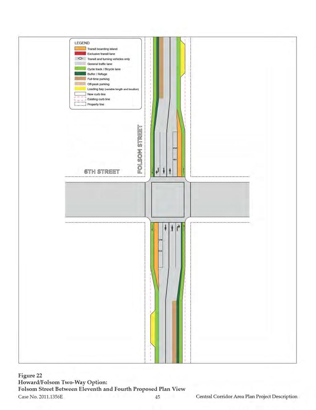
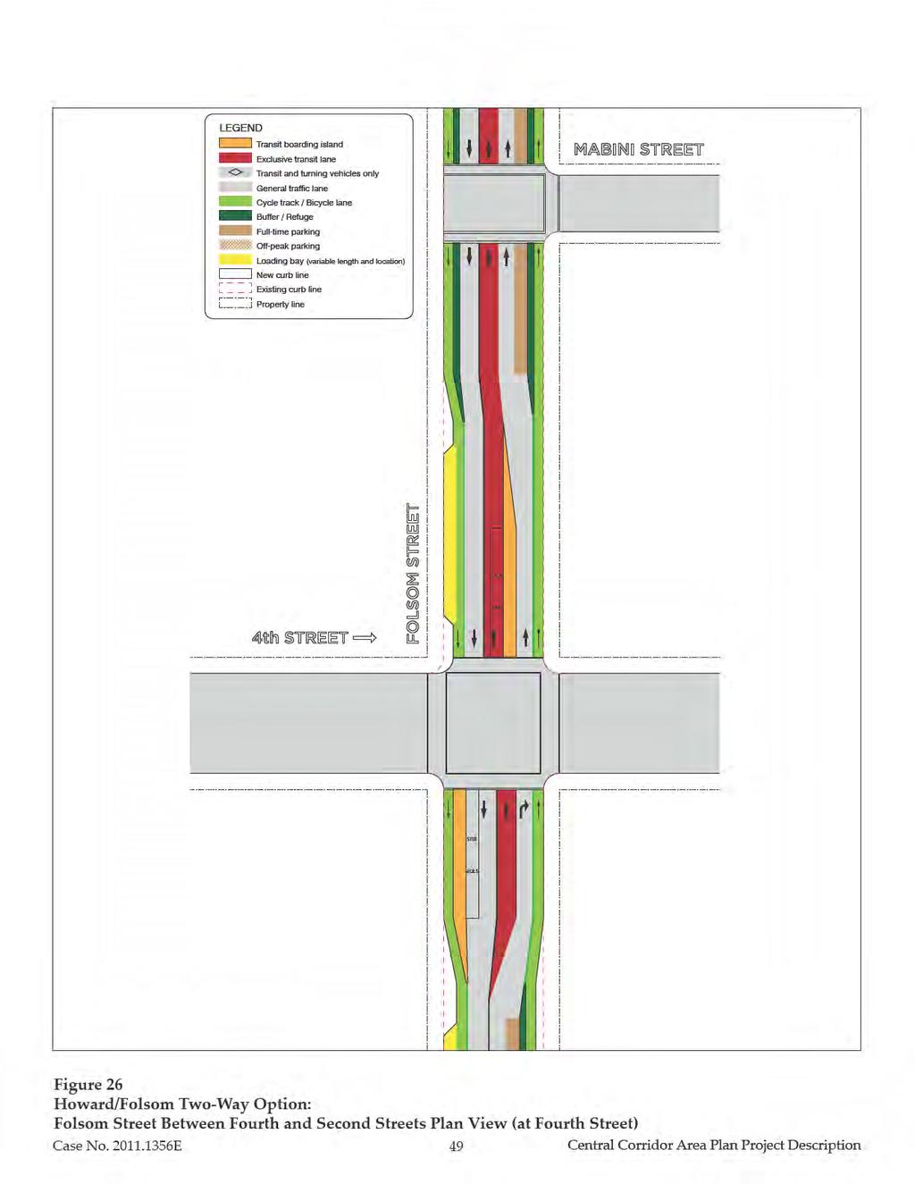
41 Sidewalks between Eleventh and Sixth streets would be widened to about 15 feet. Figures 19 and 20 (on pages 42 and 43, respectively), depict a typical cross section and plan graphic for this segment of Howard Street under the two-way option. Under the two-way option, Folsom Street between Eleventh and Fourth streets would be modified to have one eastbound and one westbound travel lane and one-way buffered or raised cycle tracks in both directions. Parallel parking would be provided on one side of the street at all times, but on block faces without parallel parking where on-street loading would be required, loading bays could be placed within the sidewalk. Right-turn pockets would be provided at intersections which (along with a right-turn signal) would be necessary in order to separate right-turning vehicles from bicycles. Sidewalks would be widened to about 15 to 18 feet. Figures 21 and 22 on pages 44 and 45 illustrate a typical cross section and plan view for Folsom Street between Eleventh and Fourth streets under the two-way option. Under the two-way option, between Fourth and Second streets, Folsom Street would be modified to have one eastbound transit-only lane, one eastbound travel lane, one westbound travel lane, and one-way buffered or raised cycle tracks in both directions. Westbound auto traffic on Folsom Street would be required to turn right onto northbound Third Street during peak periods (vehicle access to the north curb of Folsom between Third and Fourth would be accommodated by turning left onto westbound Folsom from northbound Third). Eastbound vehicle traffic on Folsom Street would be required to turn right onto southbound Fourth Street during peak periods (vehicle access to the south curb of Folsom between Fourth and Third would be accommodated by turning left onto eastbound Folsom from southbound Fourth). Parallel parking would be provided adjacent to the eastbound cycle track. Under the two-way option, between Second Street and The Embarcadero, Folsom Street would be modified to have one eastbound and one westbound travel lane and one-way buffered cycle tracks in both directions. Parallel parking would be provided on both sides of the street alongside the cycle tracks at all times. Right-turn pockets would be provided at intersections which (along with a right-turn signal) would be necessary in order to separate right-turning vehicles from bicycles. Consistent with the TCDP, the north sidewalk would be widened to about 25 feet, and the south sidewalk would be widened to about 15 feet. Case No E 41 Central Corridor Plan Area Project Description
42
43
44
45
.")
46 Under the two-way option, modifications to additional streets would also occur. Essex Street would be closed to vehicle access in order to remove the connection between Folsom Street and the Bay Bridge, but a southbound transit-only lane would be retained; see Figure 23 (below). To accommodate vehicles destined to the Bay Bridge from southbound Fourth Street, Harrison Street would be converted into two-way operation between Third and Fourth streets (see description of Harrison Street below). Figures 24 through 26 on pages 47 to 49 show a plan view graphic for Folsom Street between Fourth and Second streets under the two-way option. Figure 27 on page 50 depicts a plan view graphic for Folsom Street at Main Street. Figure 23. Essex Street Closure Case No E 46 Central Corridor Plan Area Project Description
47
48
49
50
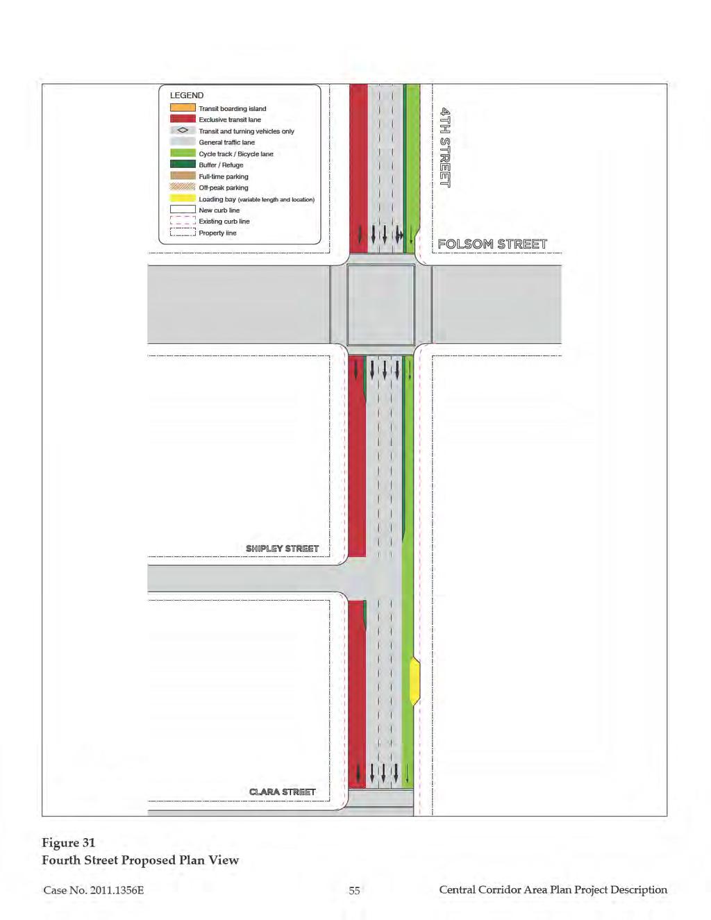
51 Third Street Third Street is proposed to be modified between King and Market streets. Currently this section of Third Street has three northbound travel lanes and one northbound transit-only lane, with parallel parking along the east and west curbs. During peak hours, on-street parking is prohibited along the east curb to reduce parking friction with transit vehicles; on-street parking is also prohibited along the west curb north of Bryant Street during peak hours to create a fourth travel lane. The proposal would reconfigure Third Street to include three northbound travel lanes, a protected transit lane along the east curb, and a one-way cycle track along the west curb at all times. Sidewalks would be widened to about 15 feet, and on-street parking would be removed. At locations where on-street loading would be required, loading bays could be installed within the sidewalk. At signalized intersections, turning vehicle movements would be separated from bicycle, transit and pedestrian traffic with separate traffic signal phases. Existing and proposed typical cross sections along Third Street are shown in Figure 28 on page 52. A plan view graphic for Third Street is provided in Figure 29 on page 53. Fourth Street Fourth Street would be modified between Market and Harrison streets. Currently this section of Fourth Street generally has three southbound travel lanes and one southbound transit-only lane, and parallel parking along the east and west curbs. The project would reconfigure Fourth Street to include three southbound travel lanes, a protected transit lane along the west curb, and a one-way cycle track along the east curb at all times. Sidewalks would be widened to about 15 feet, and on-street parking would be removed. At locations where on-street loading would be required, loading bays could be installed within the sidewalk. At signalized intersections, turning vehicle movements would be separated from bicycle, transit, and pedestrian traffic with separate signal phases. A typical cross section and plan graphic for the proposed street network changes along Fourth Street are shown in Figures 30 and 31 (on pages 54 and 55, respectively). Case No E 51 Central Corridor Plan Area Project Description
52
53
54
55
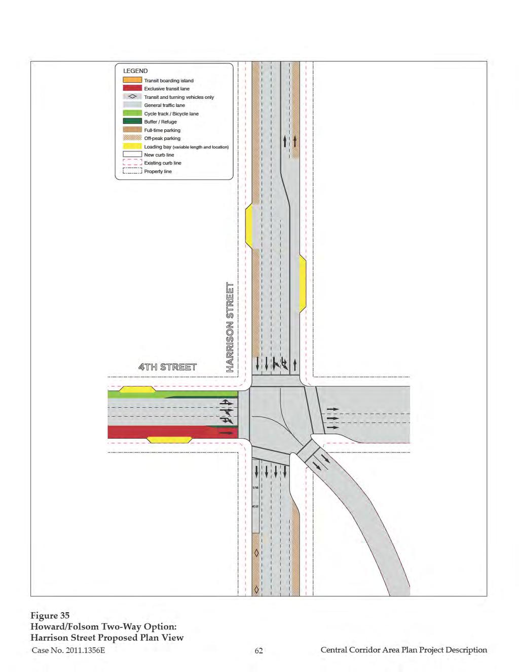
56 Harrison Street Harrison Street would be modified between Second and Eleventh Streets. Currently this section of Harrison Street is configured with five travel lanes in the westbound direction (however, between Third and Second streets there are three westbound lanes and two eastbound lanes), parallel parking along both the north and south curbs, and 8 foot sidewalks. See Figure 32 on page 57 for a typical cross section of the existing conditions along Harrison Street. The project would reconfigure Harrison Street to include a transit-only lane for the 8X Bayshore Express, and sidewalks would be widened within the Plan area between Sixth and Second streets. The length of the transit-only lane would vary between the One-way and Two-Way Howard/Folsom options. Under the Two-way Howard/Folsom Option, Harrison Street between Seventh and Tenth streets would have angled parking and fewer travel lanes. This is elaborated below. One-Way Howard/Folsom Option: Between Second and Third streets, there would be one westbound transit-only lane, two westbound travel lanes, two eastbound travel lanes, and no parallel parking during peak periods. During off-peak periods, parallel parking would be permitted along the north and south curbs, resulting in two westbound travel lanes and one eastbound travel lane; no transitonly lane would be provided during off-peak periods. Sidewalks would be widened to about 15 feet. At locations where on-street loading would be required at all times, about 7-foot wide loading bays could be installed within the sidewalk. Between Third and Sixth streets, there would be four westbound travel lanes, one westbound transit-only lane, and no parallel parking during peak periods. During off-peak periods, parallel parking would be permitted along the north and south curbs, resulting in three westbound travel lanes; no transit-only lane would be provided during off-peak periods. Sidewalks would be widened to about 15 feet. At locations where on-street loading would be required at all times, about 7-foot wide loading bays could be installed within the sidewalk. A typical cross section and plan graphic of this segment of Harrison Street under the One-Way Howard/Folsom Option is shown in Figures 32 and 33 (on pages 57 and 58, respectively). Case No E 56 Central Corridor Plan Area Project Description
57 Existing Sidewalk Parking Parking Sidewalk ROW 82.5 Proposed Loading where needed P Off-peak Peak P Off-peak Peak Loading where needed Sidewalk Sidewalk Figure 32 Howard/Folsom One-Way Option: Harrison Street Existing and Proposed Typical Cross Sections Case No E 57 Central Corridor Area Plan Project Description
58
59 Between Sixth and Tenth streets, there would be four westbound travel lanes, one westbound transit-only lane, and parallel parking along the north and south curbs at all times. Sidewalks would remain 8 feet wide. At Seventh Street, there would be a transit-only signal phase that would enable the outbound 8X Bayshore bus to turn left onto the southbound US 101 freeway onramp from the right lane. Between Tenth and Eleventh streets, there would be two westbound travel lanes, one westbound transit-only lane, one eastbound travel lane, and parallel parking along both the north and south curbs at all times. Sidewalks would remain 8 feet wide. Two-Way Howard/Folsom Option: Between Second and Fourth streets, there would be three westbound travel lanes, two eastbound travel lanes, and no parallel parking during peak periods. Harrison would be converted from one-way to two-way operation between Third and Fourth streets, in order to enable Bay Bridge-bound traffic to utilize Harrison Street instead of Folsom Street (see Two- Way Howard/Folsom description, above). During off-peak periods, parallel parking would be permitted along the north and south curbs, resulting in two westbound travel lanes and one eastbound travel lane. Sidewalks would be widened to about 15 feet. At locations where onstreet loading would be required at all times, 7-foot wide loading bays could be installed within the sidewalk. Between Fourth and Sixth streets, there would be four westbound travel lanes, one westbound transit-only lane, and no parallel parking during peak periods. During off-peak periods, parallel parking would be permitted along the north and south curbs, resulting in three westbound travel lanes; no transit-only lane would be provided during off-peak periods. Sidewalks would be widened to about 15 feet. At locations where on-street loading would be required at all times, about 7-foot wide loading bays could be installed within the sidewalk. Between Sixth and Seventh streets, there would be four westbound travel lanes, one westbound transit-only lane, and parallel parking along the north and south curbs at all times. Sidewalks would remain 8 feet wide. At Seventh Street, there would be a transit-only signal phase that would enable the outbound 8X Bayshore bus to turn left onto the southbound US 101 freeway onramp from the right lane. Between Seventh and Ninth streets, there would be three westbound travel lanes, angled parking along the north curb at all times, and parallel parking along the south curb at all times. Case No E 59 Central Corridor Plan Area Project Description
60 Sidewalks would remain 8 feet wide. Between Ninth and Tenth streets, there would be two westbound travel lanes, and angled parking along both the north and south curbs at all times. Sidewalks would remain eight feet wide. Between Tenth and Eleventh streets, there would be three westbound travel lanes, one eastbound travel lane, and parallel parking along both the north and south curbs at all times. Sidewalks would remain 8 feet wide. (See Figure 34 and Figure 35 on pages 61 and 62, respectively.) Bryant Street Bryant Street would be modified between Second and Seventh streets. Typical cross sections for existing conditions along Bryant Street are shown in Figure 36 on page 63. Currently this section of Bryant Street is configured with five travel lanes in the eastbound direction, parallel parking along both the north and south curbs, and 8 foot sidewalks. The proposed project would reconfigure Bryant Street to include a transit-only lane for the 8X Bayshore Express between Seventh and Third streets, and to widen sidewalks within the Plan area between Sixth and Second streets as shown in typical cross section and plan view on Figures 36 and 37 (on pages 63X and 64, respectively). Specifically: Between Seventh and Sixth streets, there would be four eastbound travel lanes, one eastbound transit-only lane, and parallel parking along the north and south curbs at all times. Sidewalks would remain 8 feet wide. Between Sixth and Third streets, there would be four eastbound travel lanes, one eastbound transit-only lane, and no parallel parking during peak periods. During offpeak periods, parallel parking would be permitted along the north and south curbs, resulting in three travel lanes; no transit-only lane would be provided during off-peak periods. Sidewalks would be widened to about 15 feet. At locations where on-street loading would be required at all times, about 7-foot wide loading bays would be installed within the sidewalk. At Third Street, there would be a transit-only signal phase that would enable the inbound 8X Bayshore bus to turn left onto northbound Third Street from the right lane. At Fifth Street, there would be a transit-only signal phase that would enable the inbound 27 Bryant bus to turn left onto northbound Fifth Street from the right lane (with implementation of the TEP, the inbound 27 would be rerouted off of Bryant Street and onto Folsom Street, in which case the transit-only signal phase would no longer be required). Case No E 60 Central Corridor Plan Area Project Description
61 Existing Sidewalk Parking Parking Sidewalk ROW 82.5 Proposed Loading where needed P Off-peak Peak P Off-peak Peak Loading where needed Sidewalk Sidewalk Figure 34 Howard/Folsom Two-Way Option: Harrison Street Existing and Proposed Typical Cross Sections Case No E 61 Central Corridor Area Plan Project Description
62
63 Existing Sidewalk Parking Parking Sidewalk ROW 82.5 Proposed Loading where needed P Off-peak Peak P Off-peak Peak Loading where needed Sidewalk Sidewalk Figure 36 Bryant Street Existing and Proposed Typical Cross Sections Case No E 63 Central Corridor Area Plan Project Description
64
65 Between Third and Second streets, where transit does not operate, five eastbound travel lanes would be provided during peak periods, and no parallel parking. During off-peak travel periods, parallel parking would be permitted along the north and south curbs, resulting in three travel lanes. Sidewalks would be widened to about 15 feet. At locations where on-street loading would be required at all times, about 7-foot wide loading bays could be installed within the sidewalk. Brannan Street Brannan Street would be modified between Second and Sixth streets. Currently this section of Brannan Street is configured with two travel lanes in both the eastbound and westbound directions, parallel parking along both the north and south curbs, and 10 foot sidewalks. The project would reconfigure Brannan Street to have one travel lane in both the eastbound and westbound directions. One-way buffered cycle tracks in each direction would be installed along the north and south curbs. Sidewalks would be widened to about 15 feet. At midblock locations, parallel parking would be permitted adjacent to either the north or south cycle track buffer. At intersection approaches, parking would be removed to create a right-turn pocket, which (along with a right-turn signal) would be necessary in order to separate right-turning vehicles from bicycles. Figures 38 and 39 (on pages 66 and 67, respectively) depict a typical cross section and plan graphic for proposed modifications to Brannan Street. E.5. Open Space and Public Realm Improvements Like SoMa generally, the Central Corridor Plan area has limited public open spaces and facilities. Yerba Buena Gardens, including its children s garden and carousel, in the north of the Plan area and South Park in the southeast are the only large-scale open space facilities in the Plan area. South Park is the only Recreation and Park Department property, although Victoria Manalo Draves Park and South of Market Recreation Center are just beyond the western Plan area boundary. The uneven distribution of these community assets leaves portions of the area underserved with open space. The June 2011 draft of the San Francisco General Plan s Recreation and Open Space Element (Draft ROSE) identifies portions of the Plan area as in need of new public open space. Case No E 65 Central Corridor Plan Area Project Description
66
67
68 The Western SoMa Community Plan and East SoMa Area Plan identify two areas for open space acquisition- Fourth Street between I-80 and Townsend Street and near the block bounded by Howard, Fourth, Folsom and Fifth streets. These area plans have also identified streets and alleys in the area for improvement as green connections linking neighborhoods to open space. Both the Draft ROSE and the San Francisco Better Streets Plan endorse these improvements. The Plan seeks to create new public open space and recreation facilities. Existing and Proposed Open Spaces are shown in Figure 40 on page 69. The Plan s open space principles are described below. 1. Create new publicly owned open space and recreation amenities throughout the Central Corridor Plan area. Proposed amenities include: An expanded mini-plaza at the intersection of Annie and Market streets to Stevenson Street; a new pedestrian plaza closed to vehicular traffic between Mission Street and Ambrose Bierce Alley; and a single-surface shared street 8 along the remainder of Annie Street between the two plazas. A new linear open space on a portion of the right-of-way on Bluxome Street between Fourth and Fifth Streets would be created by consolidating the vehicular area to two lanes of traffic and one parallel parking lane, as opposed to the current configuration containing diagonal parking. The Plan includes a recommendation to study the conversion of a portion of the San Francisco Public Utilities Commission s (SFPUC) property at 639 Bryant Street into a new mid-block public open space. The specific dimensions, design, and amenities, should this study determine it feasible to convert this property into open space, are currently unknown and would be subject to its own environmental review once a defined project is proposed. 8 A shared street is designed for pedestrian use, but also permits low volumes and speeds of vehicles and bicycles to share the right-of-way. Case No E 68 Central Corridor Plan Area Project Description

69
José Campos Manager of Planning and Design Review SPUR San José Symposium October 12, 2018
 1 Transbay: Freeways to New Ways José Campos Manager of Planning and Design Review SPUR San José Symposium October 12, 2018 2 Transbay freeway land pre-1989 3 1989 Loma Prieta Earthquake 4 TRANSBAY c.
Executive Summary General Plan Amendment Initiation
 Executive Summary General Plan Amendment Initiation HEARING DATE: AUGUST 6, 2015 Date: July 30, 2015 Case No.: 2011.0409PCA Project Address: 925 Mission Street and various parcels (aka 5M ) Existing Zoning:
Town Center (part of the Comprehensive Plan)
") Town Center (part of the Comprehensive Plan) Mercer Island Town Center Looking North (2014) In 1994, a year-long process culminated in a set of design guidelines and code requirements for the Town Center
Town Center (part of the Comprehensive Plan) Mercer Island Town Center Looking North (2014) In 1994, a year-long process culminated in a set of design guidelines and code requirements for the Town Center
Land Use and Land Use Planning
 IV.A IV.A.1 Land Use and Land Use Planning Introduction This section describes the existing land uses and Planning Code (zoning) controls in the (Plan) area and analyzes potential changes to the Plan Area
DRAFT Land Use Chapter
 Stevens Creek Urban Village DRAFT 1 18 17 Land Use Chapter INTRODUCTION This Land Use Chapter describes how the Stevens Creek Urban Village will accommodate the growth that is planned for it in the Envision
ELMVALE ACRES SHOPPING CENTRE MASTER PLAN
 ELMVALE ACRES SHOPPING CENTRE MASTER PLAN Contents 1.0 INTRODUCTION... 2 2.0 LOCATION... 2 3.0 EXISTING CONTEXT... 2 4.0 VISION & GUIDING PRINCIPLES... 2 5.0 LAND USE AND BUILT FORM... 4 5.1 St. Laurent
SAN FRANCISCO PLANNING DEPARTMENT ,~} DCfav~ 7_ ~/s' 1s5oM~ss~o~s~. Suite 400 San Francisco, CA
 ~~~~0 COUNlpom u 'Z x ~~ lb3s 0 61 v,~} SAN FRANCISCO PLANNING DEPARTMENT Certificate of Determination EXEMPTION FROM ENVIRONMENTAL REVIEW 1s5oM~ss~o~s~. Suite 400 San Francisco, CA 94103-2479 Case No.:
A. WHAT IS A GENERAL PLAN?
 I. Introduction A. WHAT IS A GENERAL PLAN? A general plan is the planning guideline for the future of a city. It contains goals and policies which regulate urban development, the protection of the natural
4.1.3 LAND USE CATEGORIES
 4.1.3 LAND USE CATEGORIES a. City Center District The City Center District incorporates the existing character and mix of uses in downtown Belmont to encourage redevelopment and new development in keeping
EXISTING COMPREHENSIVE PLAN
 EXISTING COMPREHENSIVE PLAN Town Center Land Use Element: V. LAND USE POLICIES Town Center Mercer Island's business district vision as described in "Your Mercer Island Citizen-Designed Downtown" was an
DRAFT. October Wheaton. Design Guidelines
 October 2011 DRAFT Wheaton Design Guidelines 2 Draft - Design Guidelines - Wheaton Sector Plan Contents 04 Section 1: Introduction 06 Section 2: Context 08 Section 3: Design Guidelines 09 Goal 1: Create
City of Hermosa Beach Administrative Policy #
 City of Hermosa Beach Administrative Policy # SUBJECT: Living Streets Policy Date: Approved by: City Council Authority: Public Works Department & Community Development Department Mayor, PURPOSE The City
TRANSIT NEIGHBORHOOD PLANS PROGRAM OVERVIEW
 TRANSIT NEIGHBORHOOD PLANS PROGRAM OVERVIEW OCTOBER 2017 Los Angeles Department of City Planning @LATNP and @Planning4LA Outline Introduction Policy Framework The Transit Neighborhood Plans Program Overview:
2 Project Description
 Project Description 2 Project Description The proposed project involves the adoption of the Bay Fair Transit Oriented Development (TOD) Specific Plan ( proposed Specific Plan ). The proposed Specific Plan
REQUEST Current Zoning: O-15(CD) (office) Proposed Zoning: TOD-M(CD) (transit oriented development mixed-use, conditional)
 (office) Proposed Zoning: TOD-M(CD) (transit oriented development mixed-use, conditional)") Rezoning Petition 2016-117 Zoning Committee Recommendation January 4, 2017 REQUEST Current Zoning: O-15(CD) (office) Proposed Zoning: TOD-M(CD) (transit oriented development mixed-use, conditional) LOCATION
Rezoning Petition 2016-117 Zoning Committee Recommendation January 4, 2017 REQUEST Current Zoning: O-15(CD) (office) Proposed Zoning: TOD-M(CD) (transit oriented development mixed-use, conditional) LOCATION
LAND USE AMENDMENT DOWNTOWN COMMERCIAL CORE (WARD 7) MACLEOD TRAIL SE AND 5 AVENUE SE BYLAW 254D2017
 MACLEOD TRAIL SE AND 5 AVENUE SE BYLAW 254D2017") Page 1 of 10 EXECUTIVE SUMMARY This Land Use Amendment application seeks to redesignate a full downtown block (currently the YWCA site) from a Direct Control based on the CM-2 District (Land Use Bylaw
Page 1 of 10 EXECUTIVE SUMMARY This Land Use Amendment application seeks to redesignate a full downtown block (currently the YWCA site) from a Direct Control based on the CM-2 District (Land Use Bylaw
ARLINGTON COUNTY, VIRGINIA
 ARLINGTON COUNTY, VIRGINIA County Board Agenda Item Meeting October 15, 2005 DATE: September 28, 2005 SUBJECT: Request to Advertise the adoption of the 2005 Clarendon Sector Plan C. M. RECOMMENDATION:
Policies and Code Intent Sections Related to Town Center
 Policies and Code Intent Sections Related to Town Center The Town Center Vision is scattered throughout the Comprehensive Plan, development code and the 1994 Town Center Plan. What follows are sections
CHAPTER 3 Plans and Policies
 CHAPTER 3 Plans and Policies For informational purposes, this chapter provides a summary of the plans, policies, and regulations of the City and County of San Francisco (City) applicable to the Proposed
Access Management: An Overview
 Figures 1-5 Below Evolution of development along a highway. In the early stages, land along the road is used for farming with little traffic generated. As time passes, the highway corridor becomes a de
[PLANNING RATIONALE] For Site Plan Control and Lifting of Holding Zone By-Law 101 Champagne Avenue. May 23, 2014
![[PLANNING RATIONALE] For Site Plan Control and Lifting of Holding Zone By-Law 101 Champagne Avenue. May 23, 2014](/thumbs/75/71599615.jpg "[PLANNING RATIONALE] For Site Plan Control and Lifting of Holding Zone By-Law 101 Champagne Avenue. May 23, 2014") [PLANNING RATIONALE] For Site Plan Control and Lifting of Holding Zone By-Law 101 Champagne Avenue May 23, 2014 Contents 1.0 Introduction... 2 2.0 Site Context... 2 2.1 Adjacent Uses... 2 Figure 1: Site
[PLANNING RATIONALE] For Site Plan Control and Lifting of Holding Zone By-Law 101 Champagne Avenue May 23, 2014 Contents 1.0 Introduction... 2 2.0 Site Context... 2 2.1 Adjacent Uses... 2 Figure 1: Site
Tonight s Agenda. Summary Presentation Open House. Group Discussion Next Steps: online community wide survey
 Community Open House February 22, 2018 Tonight s Agenda Summary Presentation Open House Station 1: Project Overview and Community Input Station 2: Draft Vision and Guiding Principles Station 3: Western,
Draft for Public Review. The Market and Octavia Neighborhood Plan
 Draft for Public Review The Market and Octavia Neighborhood Plan San Francisco Planning Department As Part of the Better Neighborhoods Program December 2002 . A New Neighborhood in SoMa West OBJECTIVE.1
Clairtrell Area Context Plan
 Clairtrell Area Context Plan March 2005 Urban Development Services City Planning Contents 1. Introduction... 4 2. Development Structure... 6 2.1 Streets... 7 2.1.1 Sheppard Avenue and Bayview Avenue...
SAN FRANCISCO MUNICIPAL TRANSPORTATION AGENCY
 THIS PRINT COVERS CALENDAR ITEM NO. : 10.3 DIVISION: Sustainable Streets BRIEF DESCRIPTION: SAN FRANCISCO MUNICIPAL TRANSPORTATION AGENCY Approving the removal of Municipal Railway bus zones at various
Robbinsdale LRT Station. CDI Development Guidelines. August Overview
 Robbinsdale LRT Station August 2018 Overview The City of Robbinsdale may have the coolest opportunity site along the 13 mile stretch of the Bottineau LRT corridor / Blue Line extension. Located a block
TRANSIT-ORIENTED DEVELOPMENT POLICY DRAFT. City Planning and Development Department Kansas City, Missouri
 TRANSIT-ORIENTED DEVELOPMENT POLICY DRAFT City Planning and Development Department Kansas City, Missouri What is Transit Oriented Development (TOD)? Development that focuses land uses around a transit
YONGE STEELES CORRIDOR SECONDARY PLAN. Young + Wright / IBI Group Architects Dillon Consulting Ltd. GHK International (Canada) Ltd.
 Ltd.") PART A: PREAMBLE 1.0 PURPOSE The purpose of this Secondary Plan is to provide a development framework for intensification of the Yonge/ Steeles corridor including the north side of Steeles Avenue West
PART A: PREAMBLE 1.0 PURPOSE The purpose of this Secondary Plan is to provide a development framework for intensification of the Yonge/ Steeles corridor including the north side of Steeles Avenue West
MAIN STREET ECONOMIC DEVELOPMENT STRATEGY
 MAIN STREET ECONOMIC DEVELOPMENT STRATEGY A PATHWAY TO A BETTER POUGHKEEPSIE DRAFT Working Paper #2: Planning Strategies Submitted December 1 st, 2015 to the City of Poughkeepsie LAND USE LAW CENTER PACE
~P'~'~; SAN FRANCISCO
 ~o counr~, ~P'~'~; SAN FRANCISCO ~'.~ PLANNING DEPARTMENT a 2 757 O~~~S 0 Case No.: Project Address: Zoning: Certificate of Determination COMMUNITY PLAN EVALUATION UMU (Urban Mixed Use) District 58-X Height
QUEEN-RIVER SECONDARY PLAN
 34 QUEEN-RIVER SECONDARY PLAN 34. QUEEN RIVER SECONDARY PLAN 1. INTRODUCTION The Queen-River area is approximately 6.4 hectares and is located at the eastern edge of the Downtown as shown on Map 34-1.
The transportation system in a community is an
 7 TRANSPORTATION The transportation system in a community is an important factor contributing to the quality of life of the residents. Without a sound transportation system to bring both goods and patrons
, C-MS I June 3, 2016 $1500 pd chk #216918
 , C-MS-8 LOTS 21 THROUGH 40, INCLUSIVE, BLOCK 299 CLEMENTS ADDITION TO THE CITY OF DENVER SOUTHEAST QUARTER OF SECTION 34, TOWNSHIP 3 SOUTH, RANGE 68 WEST, SIXTH PRINCIPAL MERIDIAN, CITY
CITY OF PUYALLUP. Background. Development Services
 CITY OF PUYALLUP Development Services 333 South Meridian Puyallup WA 98371 To: City Council From: Katie Baker, AICP, Planning Division Re: South Hill Neighborhood Plan Adoption Date: (Meeting date: February
TRANSIT ORIENTED DEVELOPMENT PINELLAS COUNTY MPO LIVABLE COMMUNITIES INITIATIVE PINELLAS COUNTY COMPREHENSIVE PLAN AMENDMENTS
 PINELLAS COUNTY MPO LIVABLE COMMUNITIES INITIATIVE MODEL LAND DEVELOPMENT CODE TRANSIT ORIENTED DEVELOPMENT PINELLAS COUNTY COMPREHENSIVE PLAN AMENDMENTS MPO Livable Communities Initiative Goal: Improve
178 Carruthers Properties Inc.
 178 Carruthers Properties Inc. Planning Rationale for 178 Carruthers Avenue Site Plan Control Application June 2014 Table of Contents 1.0 Introduction 2.0 Overview of Subject Property 3.0 Current Zoning
Transportation. Strategies for Action
 Transportation A major priority for the Overlake Neighborhood is to develop a multimodal transportation system. To achieve this system, a balance has to be found among travel, circulation and access needs;
Olde Towne Vision Plan
 Olde Towne Vision Plan Introduction In 2016, the City of Bellevue will complete its move of City offices from Olde Towne Bellevue to its new municipal complex on Wall Street. The City intends to sell its
A. Background Summary of Existing Challenges and Potential Possibilities. 1. Summary of Existing Assets and Potential Opportunities
 A. Background 1 A Main Street Master Plan Study was performed and completed in October of 2007. The study was initiated to review current land uses and development patterns along Main Street, from Parrish
3.0 URBAN DESIGN. December 6, OVERVIEW
 Urban Design 3.0 URBAN DESIGN December 6, 2007 3.1 OVERVIEW The highly urban character of Easton Place is defined by the overall design of the community. The following sections provide an overview of the
MEMORANDUM. DATE: March 15, Chairman and Members Community Redevelopment Agency. Leif J. Ahnell, C.P.A., C.G.F.O. Executive Director
 MEMORANDUM DATE: March 15, 2019 TO: FROM: Chairman and Members Community Redevelopment Agency Leif J. Ahnell, C.P.A., C.G.F.O. Executive Director SUBJECT: Camino Square, IDA No. CRP-16-02, located at 171
CONTENTS 8.0 LAND USE 8.1 GENERAL LAND USE 8.2 RESIDENTIAL 8.3 MIXED USE 8.4 COMMERCIAL 8.5 EMPLOYMENT LANDS
 8-2 Land Use 8.0 LAND USE CONTENTS 8.1 GENERAL LAND USE 8.1.1 Uses provided for in all Land Use Designations 8.1.2 Uses prohibited in Hazardous Lands, Hazardous Sites and Special Policy Areas 8.1.3 Uses
PLAN ELEMENTS WORKSHOP. April 5, 2016
 PLAN ELEMENTS WORKSHOP April 5, 2016 needs more housing. But there is no one-size fits-all solution. Every neighborhood has its own character. In some places, density is not only appropriate it is badly
CENTRAL ESTUARY PLAN AVISION FOR OAKLAND S WATERFRONT
 Central Estuary Plan A VISION FOR OAKLAND S WATERFRONT Specific Plan and Environmental Assessment Presentation to the Parks and Recreation Advisory Commission December 9, 2009 This Afternoon s Presentation
Director, Community Planning, Toronto and East York District
 Lower Yonge Precinct Plan Update STAFF REPORT ACTION REQUIRED Date: October 16, 2012 To: From: Wards: Reference Number: Toronto and East York Community Council Director, Community Planning, Toronto and
Welcome. Walk Around. Talk to Us. Write Down Your Comments
 Welcome This is an information meeting introducing the applications for proposed redevelopment of the Yorkdale Shopping Centre site at 3401 Dufferin Street and 1 Yorkdale Road over the next 20+ years,
SECTION ONE: INTRODUCTION. introduction
 introduction 1 INTRODUCTION Since it was first established in 1843 as a trading post for the Hudson s Bay Company, Victoria has evolved into a Provincial capital city that is recognized across Canada and
Establish a network of streetscaped vehicle and pedestrian routes that connect within and outside the Plan area.
 This Plan s urban design goals are to create an urban scale, walkable community with connections to transit, parks, and services and with amenities and facilities for residents and employees. The 1992
Highland Village Green Design Guidelines
 Highland Village Green Design Guidelines Publishing Information Title Highland Village Green Design Guidelins Author The City of Calgary Status DRAFT - Proposed document subject to changes Additional Copies
Old East Village Dundas Street Corridor Secondary Plan
 Old East Village Dundas Street Corridor Secondary Plan DRAF T February 2019 Contents 1.0 INTRODUCTION 1 1.1 Background 1 1.2 Location 2 1.3 Purpose and Use 3 1.4 Vision and Principles 4 2.0 CHARACTER
Status Update (2006 vs. Now) Citizen s Advisory Committee February Plan for Prosperity
 Citizen s Advisory Committee February Plan for Prosperity") Status Update (2006 vs. Now) Citizen s Advisory Committee February 2018 Plan for Prosperity 2000 2017 2000 2017 Gardnerville Population 6,000 5,760 5746 5,500 5,000 5,067 5,550 5,165 5,394 5,412 5,250
Status Update (2006 vs. Now) Citizen s Advisory Committee February 2018 Plan for Prosperity 2000 2017 2000 2017 Gardnerville Population 6,000 5,760 5746 5,500 5,000 5,067 5,550 5,165 5,394 5,412 5,250
Incentive Zoning Regulations Florida Municipal City of Orlando
 Topic: Resource Type: State: Jurisdiction Type: Municipality: Year (adopted, written, etc.): 2002 Community Type applicable to: Title: Incentive Zoning Regulations Florida Municipal City of Orlando Document
Regency Developments. Urban Design Brief. Holyrood DC2 Rezoning
 Regency Developments Urban Design Brief Holyrood DC2 Rezoning Stantec Consulting Ltd. 7-31-2017 1. Overview Regency Developments intends to rezone the lands located at 8510 and 8511 93 Avenue, within the
CENTRAL SOMA PLAN IMPLEMENTATION MATRIX
 106 CENTRAL SOMA PLAN MATRIX This document conveys what measures will be taken to implement the Central SoMa Plan, as when as how, when, and by whom they will be implemented. GOAL #1 INCREASE THE CAPACITY
5M PROJECT/ PLANNING COMMISSION INFORMATIONAL JULY 23, 2015
 5M PROJECT/ PLANNING COMMISSION INFORMATIONAL JULY 23, 2015 TIMELINE 2008-2009 2009-2011 2011-2013 2013-2014 INITIAL FACTORS > Identification of four-acre Chronicle soft site > Prioritizing preservation
Metro. Activity Center Design Guidelines. Recommendations For Developing Focused, Mixed-Use Commercial/Residential Centers
 Metro Activity Center Design Guidelines Recommendations For Developing Focused, Mixed-Use Commercial/Residential Centers Metro Activity Centers What is a MAC? Legacy, the adopted guide for the future growth
Railyard Alternatives and I-280 Boulevard Feasibility Study. MTA Board Meeting May 6, 2014
 Railyard Alternatives and I-280 Boulevard Feasibility Study MTA Board Meeting May 6, 2014 Planned Infrastructure Major pieces of new infrastructure are planned including: Downtown Rail Extension (DTX)
Table of Contents. Elm Avenue Improvement Plan City of Waco, Texas. Introduction 1. Existing Context 1 Figure 1 2.
 Table of Contents Introduction 1 Existing Context 1 Figure 1 2 Plan Guidelines 3 Future Urban Form 4 The West-End 4 Main Street 6 The East-End 7 Figure 2 9 Public Improvement Recommendations 7 General
Santa Monica Chamber of Commerce DSP Subcommittee s DSP EIR Scoping Comments and Preliminary Comments on the DSP Framework
 Santa Monica Chamber of Commerce DSP Subcommittee s DSP EIR Scoping Comments and Preliminary Comments on the DSP Framework The Chamber of Commerce s DSP Subcommittee s comments on the scope of the DSP
13 THORNHILL YONGE STREET STUDY IMPLEMENTATION CITY OF VAUGHAN OPA 669 AND TOWN OF MARKHAM OPA 154
 13 THORNHILL YONGE STREET STUDY IMPLEMENTATION CITY OF VAUGHAN OPA 669 AND TOWN OF MARKHAM OPA 154 The Planning and Economic Development Committee recommends the adoption of the recommendations contained
WEST LOOP DESIGN GUIDELINES CHECKLIST
 WEST LOOP DESIGN GUIDELINES CHECKLIST Section 1.0 General Strategies 1.1 DESIGN EXCELLENCE: ENCOURAGE HIGH QUALITY AND INNOVATIVE DESIGN OF NEW BUILDINGS WITHIN THE WEST LOOP WITHOUT BEING PRESCRIPTIVE
KANATA CENTRUM 255 KANATA AVENUE OFFICIAL PLAN AMENDMENT ZONING BY-LAW AMENDMENT
 KANATA CENTRUM 255 KANATA AVENUE OFFICIAL PLAN AMENDMENT ZONING BY-LAW AMENDMENT JUNE 2015 PREPARED BY: FOTENN Consultants Inc. 223 Mcleod Street Ottawa, ON K2P OZ8 (613) 730-5709 PREPARED FOR: Kanata
Draft for Public Review. The Market and Octavia Neighborhood Plan
 Draft for Public Review The Market and Octavia Neighborhood Plan San Francisco Planning Department As Part of the Better Neighborhoods Program December 2002 IOverview Why Plan a Better Neighborhood Here
SECTION TWO: Urban Design Concepts
 SECTION TWO: Urban Design Concepts The Gardnerville Plan for Prosperity shapes economic opportunities presented by regional growth. The Urban Design Concepts provide policies and concepts for land use,
Urban Design Manual PLANNING AROUND RAPID TRANSIT STATIONS (PARTS) Introduction. Station Study Areas
 Introduction. Station Study Areas") 111111 PLANNING AROUND RAPID TRANSIT STATIONS (PARTS) Introduction The ION rapid transit system will link Waterloo, Kitchener and Cambridge through a central transit corridor (CTC). There are a number
111111 PLANNING AROUND RAPID TRANSIT STATIONS (PARTS) Introduction The ION rapid transit system will link Waterloo, Kitchener and Cambridge through a central transit corridor (CTC). There are a number
Urban Planning and Land Use
 Urban Planning and Land Use 701 North 7 th Street, Room 423 Phone: (913) 573-5750 Kansas City, Kansas 66101 Fax: (913) 573-5796 Email: planninginfo@wycokck.org www.wycokck.org/planning To: From: City Planning
John M. Fleming Managing Director, Planning and City Planner. Old East Village Dundas Street Corridor Secondary Plan Draft Terms of Reference
 Report to Planning and Environment Committee To: From: Subject: Chair and Members Planning & Environment Committee John M. Fleming Managing Director, Planning and City Planner Old East Village Dundas Street
VISION AND GUIDING DESIGN PRINCIPLES
 pleasure point commercial corridor VISION AND GUIDING DESIGN PRINCIPLES Public Draft November 26, 2018 County of Santa Cruz with assistance from MIG CONTENTS PART I: INTRODUCTION AND VISION... 3 Community
Good Design Guidelines for Downtown. Preliminary Findings and Recommendations
 Good Design Guidelines for Downtown Preliminary Findings and Recommendations City Council Meeting - February 5, 2017 Advisory Committee Team: Larry Paul: Planning Commission /Architect Bruce Bagnoli: Business
Workshop 3. City of Burlington Waterfront Hotel Planning Study. September 14, The Planning Partnership
 Workshop 3 City of Burlington Waterfront Hotel Planning Study September 14, 2017 The Planning Partnership The Waterfront Hotel Planning Study 01 The Brant & Lakeshore Planning Study will establish a Strategic
DOWNTOWN GEORGETOWN PLANNING STUDY
 DOWNTOWN GEORGETOWN PLANNING STUDY Community Workshop #3 Thursday, May 4, 08 The Planning Partnership OVERVIEW OF STUDY, PROCESS & MILESTONES We are here PURPOSE OF THE STUDY To develop a clear vision
SAN FRANCISCO PLANNING DEPARTMENT
 PLANNING DEPARTMENT Certificate of Determination EXEMPTION FROM ENVIRONMENTAL REVIEW Case No.: Project Address: Zoning: UMU (Urban Mixed Use) Zoning District 68-X Height and Bulk District Life Science
Land Use Amendment in Southwood (Ward 11) at and Elbow Drive SW, LOC
 at and Elbow Drive SW, LOC") 2018 November 15 Page 1 of 10 EXECUTIVE SUMMARY This land use amendment application was submitted by Rick Balbi Architect on 2017 August 31 on behalf of Sable Developments Ltd, and with authorization from
2018 November 15 Page 1 of 10 EXECUTIVE SUMMARY This land use amendment application was submitted by Rick Balbi Architect on 2017 August 31 on behalf of Sable Developments Ltd, and with authorization from
ROBBINSDALE LRT STATION CDI DEVELOPMENT GUIDELINES
 August 2018 OVERVIEW The City of Robbinsdale has a prime-opportunity site in the middle of the 13 mile stretch of the Bottineau LRT corridor / Blue Line extension. Robbinsdale offers a prominent, vital,
Welcome to the Oakridge Centre Open House
 Welcome to the Oakridge Centre Open House Why is the City hosting this event? This open house is to inform you of a rezoning application submitted to the City of Vancouver to amend the existing CD-1 (Comprehensive
City of Farmington. Downtown Plan. Amendment to the 1998 Master Plan Adopted October 11, 2004
 City of Farmington Amendment to the 1998 Master Plan Adopted October 11, 2004 Introduction Planning Background 1 Scope and Components of the Plan Amendment 2 Concept Introduction 3 Plan Concepts 3 Conceptual
Lehigh Acres Land Development Regulations Community Planning Project
 Lehigh Acres Land Development Regulations Planning Effort Summary In July, 2010 Commissioner Frank Mann invited the Lehigh Acres community to start discussing how to achieve their recently adopted community
Secrest Short Cut and Monroe Expressway Small Area Plan AUGUST 29, 2018
 Secrest Short Cut and Monroe Expressway Small Area Plan AUGUST 29, 2018 Background and Process Monroe Expressway will be open by the end of 2018 Union County and Indian Trail identified a need to revisit
Developer s Program. The Station at East 54
 Developer s Program The Station at East 54 Existing Conditions The Station at East 54 is proposed for a 1.12 acre site at the northeast corner of Hamilton Road and Prestwick Road, tucked between the East
Midtown Greenway Land Use and Development Plan Executive Summary
 Midtown Greenway Land Use and Development Plan Executive Summary Introduction The Midtown Greenway Land Use and Development Plan sets policy direction for land use and development in the Midtown Greenway
5.1 Site Plan Guidelines
 5. Community Core Guidelines Development of the Community Core will take place by plan of subdivision and site plan approval. It will occur in a phased manner that will reflect the timing of residential
RAILWAY LANDS EAST SECONDARY PLAN
 17 RAILWAY LANDS EAST SECONDARY PLAN 17. RAILWAY LANDS EAST SECONDARY PLAN 1. INTERPRETATION 1.1 The lands affected by the Railway Lands East Secondary Plan are shown on Map 17-1. 1.2 The boundaries of
Chapter 1: Introduction
 Chapter 1: Introduction The Penn Avenue Community Works Corridor Vision and Implementation Framework presents an integrated communitybased vision and a coordinated, long-term implementation framework for
Small Area Plan. South Gateway
 Small Area Plan Adopted May 12, 2008 South Gateway Purpose. The South Gateway Small Area Plan defines the City s expectations for the future of the southern entrance to the City at Interstate 85 and Highway
38 Queen s University Campus Master Plan Part 1
 38 Queen s University Campus Master Plan Part 1 46 The Campus at the City Scale Chapter 4 The Campus at the City Scale 39 Queen s is an urban University centrally located in Kingston. Decisions made by
Mr. Craig Young, Managing Principal Tidewater Capital 25 Taylor Street San Francisco, CA October 27, 2014
 95 Brady Street San Francisco, CA 94103 415 541 9001 info@sfhac.org www.sfhac.org Mr. Craig Young, Managing Principal Tidewater Capital 25 Taylor Street San Francisco, CA 94102 Ref: 1028 Market Street
SAN FRANCISCO. x ~ OT`s 0~5` PLANNING DEPARTMENT. Certificate of Determination COMMUNITY PLAN EVALUATION PROJECT DESCRIPTION CEQA DETERMNATION
 y;~~~ counr~on u "'s' 9z x ~ OT`s 0~5` SAN FRANCISCO PLANNING DEPARTMENT COMMUNITY PLAN EVALUATION Case No.: Project Address: Zoning: RTO-M (Residential Transit Oriented-Mission) Use District Calle 24
Executive Summary. NY 7 / NY 2 Corridor
 Executive Summary NY 7 / NY 2 Corridor Transportation and Land Use Study December 2005 Prepared for: Town of Colonie Capital District Transportation Committee Prepared by: Introduction: Land use decisions
CITYWIDE PLANNING DIVISION
 2014-2019 CITYWIDE PLANNING DIVISION a five-year work program for long-range planning November 2016 TODAY S PRESENTATION 1. Overview 2. Planning Priorities 3. Topics/Focus Areas 5. Essential Practices
Public Open House. Overview of the Downtown Plan Official Plan Amendment April 23, 2018
 Public Open House Overview of the Downtown Plan Official Plan Amendment April 23, 2018 1 A 25-Year Plan for Downtown To ensure growth contributes positively to Toronto s Downtown as a great place to live,
The University District envisions, in its neighborhood
 Envisioning the University District Link Light Rail in Seattle s neighborhoods CIY OF SEALE CONCEP-LEVEL SAION AREA PLANNING RECOMMENDAION RESOLUION # 30165 EXHIBI L Vision 08.2000 he University District
Uptown Rideau Street Secondary Plan [Amendment #166, January 12, 2016]
![Uptown Rideau Street Secondary Plan [Amendment #166, January 12, 2016]](/thumbs/76/73760497.jpg "Uptown Rideau Street Secondary Plan [Amendment #166, January 12, 2016]") [Amendment #166, January 12, 2016] The policies of this Secondary Plan are in effect, save and except for the property at 560 Rideau Street, for which there remains a site specific appeal to this Secondary
[Amendment #166, January 12, 2016] The policies of this Secondary Plan are in effect, save and except for the property at 560 Rideau Street, for which there remains a site specific appeal to this Secondary
URBAN DESIGN BRIEF. 2136&2148 Trafalgar Road. Town of Oakville
 URBAN DESIGN BRIEF 2136&2148 Trafalgar Road Town of Oakville Prepared By: METROPOLITAN CONSULTING INC For 2500674 Ontario Inc November 2016 TABLE OF CONTENTS Page No. 1.0 Introduction/Description of Subject
FRUITVALE TRANSIT VILLAGE (Phase 2) Residential Project
 Residential Project") FRUITVALE TRANSIT VILLAGE (Phase 2) Residential Project DEVELOPER: SIGNATURE PROPERTIES ARCHITECT: HKIT ARCHITECTS April 23, 2010 TABLE OF CONTENTS 3 Vision 4 Description of Site 5 Guiding Concepts 6
FRUITVALE TRANSIT VILLAGE (Phase 2) Residential Project DEVELOPER: SIGNATURE PROPERTIES ARCHITECT: HKIT ARCHITECTS April 23, 2010 TABLE OF CONTENTS 3 Vision 4 Description of Site 5 Guiding Concepts 6
Zoning Code Issues Prioritization
 City of Streetsboro The City of Streetsboro has begun the process of updating its Zoning Code. The new Zoning Code will be based on the recently adopted Comprehensive Plan, which establishes the overall
1.3 TRANSIT VISION 2040 FROM VISION TO ACTION THEME 1: PUTTING TRANSIT AT THE CENTRE OF COMMUNITIES. Fully integrate transit with community planning
 TRANSIT VISION 2040 FROM VISION TO ACTION TRANSIT VISION 2040 defines a future in which public transit maximizes its contribution to quality of life with benefits that support a vibrant and equitable society,
SUBJECT: PREDEVELOPMENT PLAN REVIEW OF PROJECT LOCATED AT E. COLORADO BOULEVARD (PASEO COLORADO)
") TO: FROM: Honorable Mayor and City Council Planning & Community Development Department SUBJECT: PREDEVELOPMENT PLAN REVIEW OF PROJECT LOCATED AT 260-400 E. COLORADO BOULEVARD (PASEO COLORADO) RECOMMENDATION:
TO: FROM: Honorable Mayor and City Council Planning & Community Development Department SUBJECT: PREDEVELOPMENT PLAN REVIEW OF PROJECT LOCATED AT 260-400 E. COLORADO BOULEVARD (PASEO COLORADO) RECOMMENDATION:
THE GREEN VISION WORKSHOP Friday, November 6, 2009
 THE GREEN VISION WORKSHOP Friday, November 6, 2009 SUSTAINABLE LONG RANGE PLANNING IN SANTA MONICA Eileen Fogarty Director, Planning and Community Development GREEN BUILDINGS Santa Monica has the most
2040 LUP is a part of the Comprehensive Plan and carries the same legal authority. Economic Challenges
 1.1. Guiding Anchorage s Growth Where will new residents settle over the next two decades? Where will people work, shop, and play? Will there be enough room to grow? How will Anchorage look? Will growth
SAN RAFAEL GENERAL PLAN 2040 INTRODUCTION AND OVERVIEW
 SAN RAFAEL GENERAL PLAN 2040 INTRODUCTION AND OVERVIEW Steering Committee Presentation February 14, 2018 Purpose of General Plan Guide land use and development decisions Coordinate transportation, infrastructure,