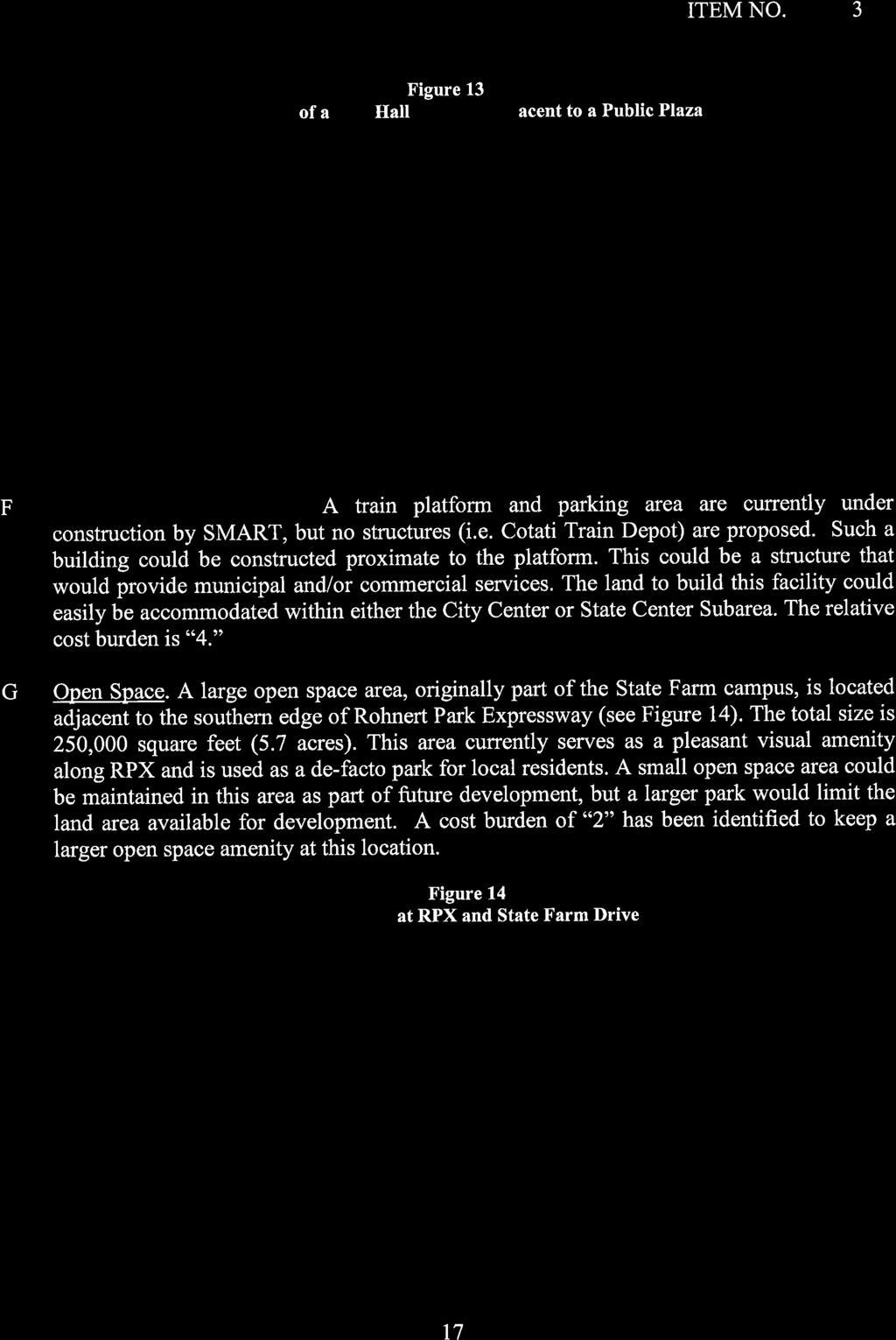
|
|
|
- Melvin Marsh
- 5 years ago
- Views:
Transcription

1


2

3

4

5

6

7

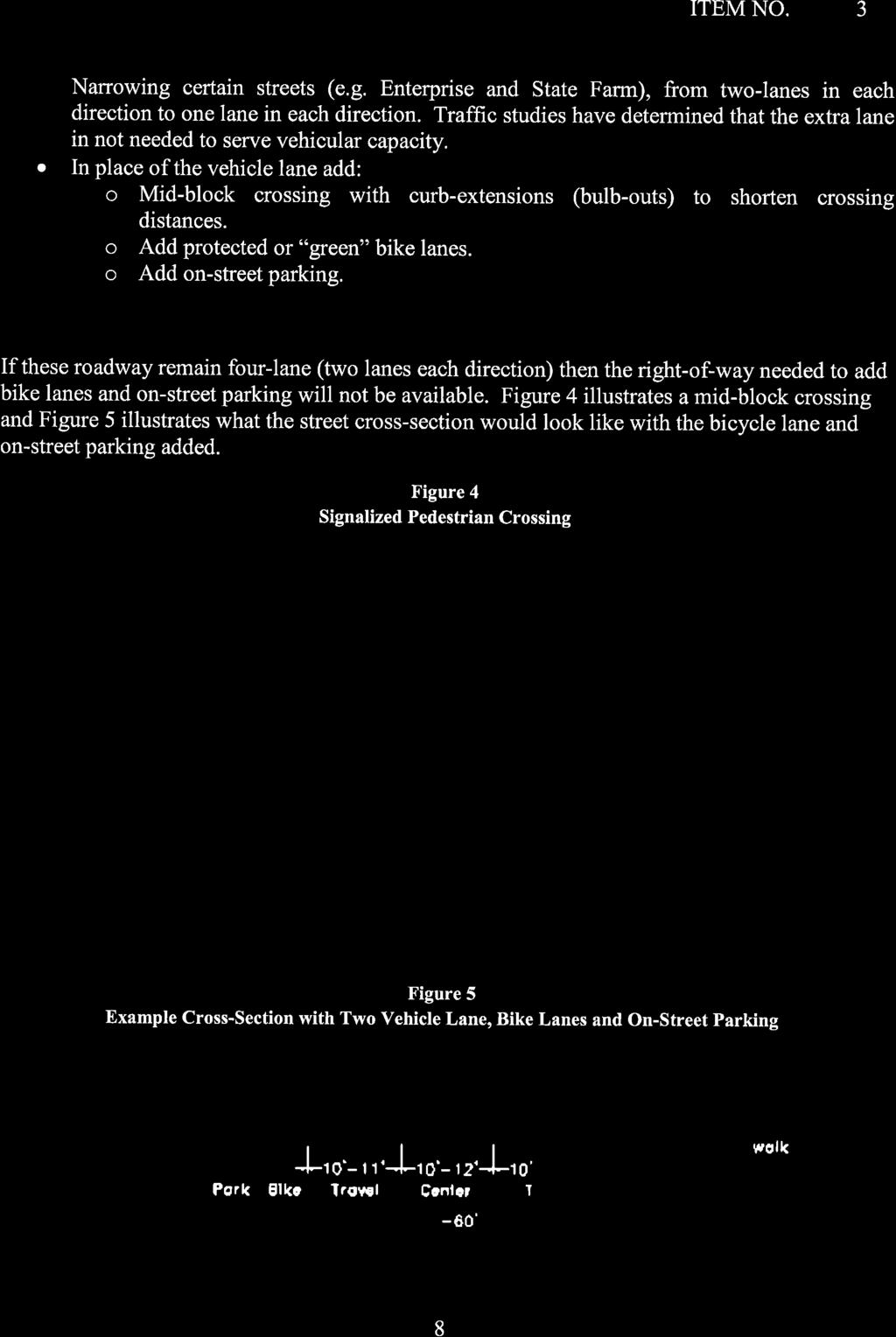
8

9

10


11


12

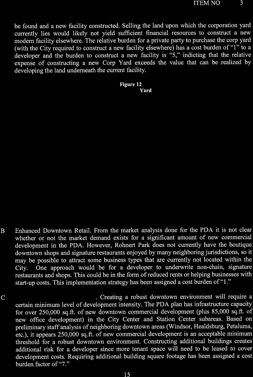
13

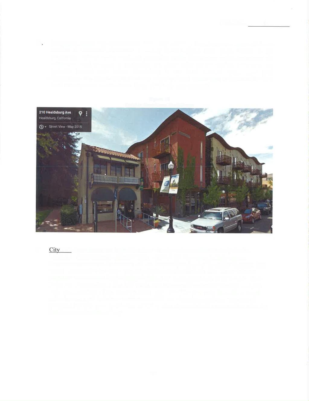
14
15
16
17


18
19
20


21 City of Rohnert Park CENTRAL ROHNERT PARK PRIORITY DEVELOPMENT AREA PLAN Preliminary Public Review Draft August 2015 Prepared for: City of Rohnert Park Development Services Department Planning Division Prepared by: AECOM In Partnership with: Mogavero Notestine Associates, Office of John Nicolaus, W-Trans, BAE

22 City of Rohnert Park CENTRAL ROHNERT PARK PRIORITY DEVELOPMENT AREA PLAN Preliminary Public Review Draft August 2015 Prepared for: City of Rohnert Park Development Services Department Planning Division Prepared by: In Partnership with: Logo design by Mogavero Notestine Associates
23 TABLE OF CONTENTS 1 INTRODUCTION 1.1 Chapter Overview Project Location Local Setting Regional Setting Project Background Planning Process and Community Outreach Phase I: Project Initiation, Visioning, and Outreach Phase 2: Alternatives Development Phase 3: Strategy Memos and PDA Plan Development Purpose of the Plan PDA Objectives Plan Organization PLAN CONTEXT 2.1 Chapter Overview Site Context and Character Block, Circulation, and Development Character Street, Streetscape, and Landscape Character Land Use and Regulatory Context Land Use and Development Characteristics General Plan Goals General Plan Designation Zoning Designations Circulation and Connectivity Vehicular Circulation Bike Circulation Pedestrian Circulation Transit Market Overview Employment Conditions and Job Trends Office Market Conditions Retail Market Conditions Housing Conditions VISION AND PLAN CONCEPTS 3.1 Chapter Overview Central Rohnert Park Placemaking Priorities The Plan Subarea Land Use and Development Concepts Triangle Business Subarea City Center Subarea Station Center Subarea Central Commercial Subarea Creekside Neighborhood Downtown District Circulation Concepts Park and Open Space Concepts LAND USE 4.1 Chapter Overview Land Use and Development Goals and Policies Subarea Land Use and Improvement Concepts Triangle Business Subarea City Center Subarea Station Center Subarea Central Commercial Subarea Creekside Neighborhood Subarea Downtown District Amenity Zone Pagei
24 CentralRohnertParkPriorityDevelopmentAreaPlan Draft August Land Use and Development Potential Zoning and Land Use Designations Site Development Potential Affordable Housing and Antidisplacement Housing Affordability Anti-Displacement Affordable Housing and Anti-Displacement Programs and Strategies CIRCULATION AND CONNECTIVITY 5.1 Chapter Overview Circulation and Connectivity Goals and Policies Roadway Design Concepts and Improvements Roadway Design Concepts Recommended Vehicular Circulation Improvements Typical Roadway Design Sections Bicycle and Pedestrian Design Concepts and Improvements Bicycle Facilities Pedestrian Facilities Bike and Pedestrian Intersection and Crossing Improvements Transit Design Concepts and Improvements Accessibility Parking Parking Context Parking Analysis Recommended Parking Approach and Standards COMMUNITY DESIGN GUIDELINES 6.1 Chapter Overview Community Design Goals and Policies Community Character Community-Wide Design Elements Parks and Open Space Design Landscape/Streetscape Design Building Setbacks Building Orientation Gateway and Signage System Subarea and Neighborhood Design Guidelines Commercial and Commercial Mixed-Use Infill Guidelines Mixed-Use Guidelines for the Downtown Triangle Business Subarea Guidelines Residential Guidelines (Station Center and City Center Focus) INFRASTRUCTURE AND COMMUNITY SERVICES 7.1 Introduction Utilities and Community Services Goals and Policies Utility Services Water Wastewater Storm Drainage Solid Waste Gas and Electric Cable and Telecommunications Page ii
25 Table of Contents 7.4 Community Services Public Safety Facilities Educational Facilities Park, Open Space, and Recreational Facilities IMPLEMENTATION AND FINANCING 8.1 Chapter Overview Plan Administration Implementation Actions Planning and Regulatory Actions Physical Improvements Funding and Financing Strategies Private Financing of Development Projects Funding for Public Improvements Grants Sources Implementation Action Plan Page iii
26 CentralRohnertParkPriorityDevelopmentAreaPlan Draft August 2015 FIGURES Figure 1.1: City Context Figure 1.2: Priority Development Area Existing Setting Figure 1.3: Location within the Region and Along the SMART Rail Line Figure 2.1: Figure-Ground Diagram Figure 2.2: PDA Subareas Figure 2.3: General Plan Diagram Figure 2.4: Zoning Diagram Figure 2.5: Vehicular Roadways Figure 2.6: Pedestrian and Bicycle Facilities Figure 2.7: SMART Commuter Rail Service Figure 3.1: Central Rohnert Park Plan Concept Figure 4.1: Land Use Concept Diagram Figure 4.2: Proposed Regional Commercial Overlay Zone Boundary Figure 4.3: Proposed Downtown District Amenity Zone Overlay Boundary Figure 4.4: Proposed Zoning Diagram Figure 4.5: Station Center Subarea Land Use Designations Figure 5.1: Proposed Roadway and Vehicular Circulation Improvements Figure 5.2: Future Plus Project Traffic Volumes at Study Intersections Figure 5.3: Rohnert Park Expressway Section Concept Figure 5.4: Commerce Boulevard Street Section at the Triangle Business Subarea Figure 5.5: Commerce Boulevard Street Section at the City Center Subarea Figure 5.6: Commerce Boulevard Street Section at the Central Commercial Subarea Figure 5.7: State Farm Drive Street Section in the Downtown District Figure 5.8: State Farm Drive Street Section near the Intersection of Commerce Boulevard Figure 5.9: State Farm Drive Street Section in the Triangle Business South of Professional Drive Figure 5.10: Enterprise Drive Street Section, Adjacent to the Station Center Subarea Figure 5.11: Enterprise Drive Street Section, Adjacent to the Central Commercial Subarea Figure 5.12: Professional Center Drive Street Section Figure 5.13: Padre Center Drive Street Section Figure 5.14: Bike and Pedestrian Circulation Concept Figure 5.15: Transit Concept Diagram Figure 6.1: Park and Open Space Design Figure 6.2: Landscape/Streetscape Design Figure 6.3: Urban Streetscape Zones Figure 6.4: Building Setback Diagram Figure 6.5: Streetwall Diagram Figure 6.6: Gateway and Signage System Figure 6.8: City Center/Downtown Gateway Concept Figure 7.1: Existing Water Infrastructure Figure 7.2: Existing Sewer Infrastructure Figure 7.3: Conceptual Park and Open Space Diagram Page iv
27 Table of Contents TABLES Table 2.1: Existing General Plan and Zoning Designations Table 2.2: Office Market Overview, Second Quarter Table 2.3: Retail Market Overview, Second Quarter Table 2.4: Median Home Sale Prices, Table 2.5: Rental Market Housing Trends, Table 4.1: Proposed Zoning Designations and Development Standards Table 4.2: PDA Site Development Potential Table 4.3: Affordability of Market-Rate For-Sale Housing, Rohnert Park, Table 4.4: Affordability of Market-Rate Rental Housing, Rohnert Park, Table 4.5: Citywide Regional Housing Needs Allocation, Planning Period Table 4.6: Affordable-Housing Needs in the PDA, Table 4.7: Potential Affordable Housing Programs/Strategies Table 4.8: Anti-Displacement Programs/Strategies Table 5.1: Required and Recommended Intersection Improvements at Build-Out Table 5.2: Parking Standards Table 6.1: Urban Streetscape Guidelines Table 6.2: Recommended List of Street and Accent Trees Table 6.3: Recommended List of Trees for Parks, Paseos, and Open Space Table 7.1: Estimated Water Consumption Rates Table 7.2: Land Use Summary Table 7.3: Estimated Water / Sewer Demand by Land Use in Gallons / Day Table 8.1: Action Matrix Page v
28 CentralRohnertParkPriorityDevelopmentAreaPlan Draft August 2015 ACRONYMS AND OTHER ABBREVIATIONS ADA Americans with Disabilities Act AFY acre-feet per year CAC citizens advisory committee CALGreen Code California Green Building Standards Code CFD community facilities district CIP Capital Improvement Program City City of Rohnert Park FAR floor area ratio General Plan 2000 Rohnert Park General Plan GGT Golden Gate Transit LID low impact development LID Manual Low Impact Development Technical Design Manual LOS level of service MGD million gallons per day mph miles per hour PDA Priority Development Area PDA Plan Central Rohnert Park Priority Development Area Plan PFFP Public Facilities Finance Plan PUC California Public Utilities Commission RPX Rohnert Park Expressway SCWA Sonoma County Water Agency SCT Sonoma County Transit SR State Route SMART Sonoma-Marin Area Rail Transit Subregional System Santa Rosa Subregional Water Reclamation System TAC technical advisory committee TIGER U.S. Department of Transportation, Transportation Investment Generating Economic Recovery U.S. U.S. 101 MTC Metropolitan Transportation Commission MUP multi-use path PBID property-based business improvement district Page vi
29 CHAPTER 1 INTRODUCTION 1.1 CHAPTER OVERVIEW In 2013, the City of Rohnert Park (City) received a Priority Development Area (PDA) grant from the Metropolitan Transportation Commission (MTC) to plan for the Central Rohnert Park community around the Rohnert Park Sonoma-Marin Area Rail Transit (SMART) station. The Central Rohnert Park PDA Plan is envisioned to build on the area s existing mixeduse character to support plans for the PDA as a walkable, mixed-use community; Downtown destination; and transportation hub, providing access to a variety of jobs, housing, shopping, services, and transportation options. The PDA Plan focuses on the sustainable infill and transitoriented growth of the community; and supports transit, bicycle, and pedestrian use, intended to reduce vehicular trips and accompanying air emissions. 1.2 PROJECT LOCATION Local Setting The Central Rohnert Park PDA is an existing developed, mixed-use area within Rohnert Park s city limits, located approximately 1 mile northwest of Sonoma State University (Figure 1-1). The PDA occupies a triangular project site, formed by the boundaries of U.S. Highway 101 (U.S. 101) to the west, the SMART rail line and the multi-use path (MUP) corridor to the east, and Avram Avenue/Santa Alicia Drive to the south. Primary regional access to the PDA is from two exits off U.S. 101: the Rohnert Park Expressway (RPX) exit and the Golf Course Drive/Wilfred Avenue exit, approximately 1 mile north of the RPX exit. Two creeks, Copeland and Hinebaugh Creeks, traverse Rohnert Park (Figure 1.1). The approximately 330-acre PDA rests entirely on the western side of the SMART rail line. Directly east of the SMART rail station is a mobile home park and the Foxtail Golf Course, northeast of RPX (Figure 1.2). The PDA comprises the following characteristic development areas: The vacant, former State Farm office campus site, adjacent to the Rohnert Park SMART rail station; a developing City Center area, north of the planned SMART rail station, at the intersection of City Center Drive and State Farm Drive; commercial shopping centers, accessed by Commerce Boulevard and State Farm Drive; an office and industrial business district, north of Hinebaugh Creek; and multifamily residential housing, between Enterprise Drive and Avram Avenue. The southern border of the PDA consists of single-family residential neighborhoods and an elementary school and park. U.S. 101 and regional commercial and light industrial uses border the PDA to the west Regional Setting As shown in Figure 1.3, Rohnert Park is located approximately 50 miles north of San Francisco. Rohnert Park is bordered by the cities of Cotati to the southwest and Santa Rosa to the north. By automobile, Rohnert Park is accessed regionally from U.S. 101 and State Route (SR) 116. The U.S. 101 freeway travels north-south through Rohnert Park, connecting the city to Mendocino County on the north and the San Francisco Bay Area to the south. The SR 116 freeway is connected to U.S. 101 and to cities and destinations including Sebastapol, the Sonoma Coast, and the Russian River to the west; Petaluma to the south; and the Sonoma Valley to the east. Rohnert Park has a designated stop on the SMART commuter rail line, which is expected to start service in late The SMART line will connect the major cities of Sonoma and Marin Counties along U.S. 101, from Cloverdale to the Larkspur Ferry Terminal. Rohnert Park is located approximately midway on the planned SMART rail system (Figure 1.3) and is one of 10 SMART stations planned in Sonoma County, which also include neighboring Cotati, Santa Rosa, and Petaluma. Page 1-1

30 CentralRohnertParkPriorityDevelopmentAreaPlan Draft August 2015 Figure 1.1: City Context Source: City of Rohnert Park, AECOM, 2013 Page 1-2

31 Chapter 1: Introduction Figure 1.2: Priority Development Area Existing Setting Source: City of Rohnert Park, AECOM, 2015 Page 1-3

32 CentralRohnertParkPriorityDevelopmentAreaPlan Draft August 2015 Figure 1.3: Location within the Region and Along the SMART Rail Line Sources: City of Rohnert Park 2014; AECOM 2014 Page 1-4
33 Chapter 1: Introduction Running mostly parallel to the SMART tracks is the multi-use path for non-motorized forms of transportation (e.g., bicycles, pedestrians). Like the SMART rail line, the MUP will connect the major cities of Sonoma and Marin Counties along U.S. 101, via a continuous paved path. This path is expected to be popular with bicycle and pedestrian commuters and recreational users. In Rohnert Park, the MUP will add north-south connectivity to the Class I bicycle network. Both the SMART commuter train and the MUP are intended to provide alternative forms of transportation, potentially reducing vehicular congestion on U.S. 101 and related greenhouse gas emissions. 1.3 PROJECT BACKGROUND Modeled on the neighborhood unit concept, Rohnert Park was established in 1956 as a master-planned city without a central downtown. The neighborhood unit concept emphasized the development of cities as a series of neighborhood units, with single-family residences organized around a centrally located school and park. Commercial areas were planned at the periphery of each neighborhood unit. This pattern of growth placed commercial uses away from homes, making access to shopping areas in the community more convenient by automobile. Today, commercial shopping centers in the PDA are de facto meeting places in the community. These have developed as auto-oriented commercial centers that are not safely and easily connected or accessible for bicyclists and pedestrians from the surrounding community. Before plans for the SMART rail station came to Rohnert Park, the community was engaged in the visioning and development of a city center that would serve as a central gathering place for the city and establish a symbolic and social center for the community. Now anchored by a new regional library, the City s public safety building, a community plaza, higher density housing, and neighborhood commercial uses, the City Center is developing as a central community destination. The City Center is a venue for a variety of community activities, including local events and farmers markets. Civic, commercial, and office uses along a main street and creekside open space have set the foundation and roots for envisioning Central Rohnert Park as a walkable, bikeable, and transitfriendly community place. As a result, when the State Farm office campus became available on the market in 2011, the City petitioned SMART for and was granted the opportunity to relocate the SMART rail station, then planned for Roberts Lake Road, south of the City Center. The availability of the State Farm property enabled the City to expand development of the City Center to envision a new downtown destination for Rohnert Park. In 2013, the City received the PDA planning grant from MTC to prepare this PDA Plan and the supporting environmental document. This PDA Plan guides and sets a holistic vision for the land use, development, and circulation framework for Central Rohnert Park. It leverages the coming SMART station and MUP to support creation of a transit-oriented, pedestrian-friendly downtown for Rohnert Park. The PDA Plan also promotes infill growth supporting development of Central Rohnert Park as a complete community, with a mix of uses and greater range of transit, bicycle, and pedestrian circulation options. 1.4 PLANNING PROCESS AND COMMUNITY OUTREACH With receipt of the PDA grant from the MTC, the City of Rohnert Park retained the services of a project consultant team to help develop this PDA Plan and supporting environmental document. Work on the PDA Plan involved several phases and community outreach activities, summarized in the following sections Phase I: Project Initiation, Visioning, and Initial Outreach The planning process began with a project kickoff meeting in July 2013, followed by preparation of a PDA Profile report. In the PDA Profile Report, the consultant team collected information and analyzed existing physical, demographic, and market conditions in the PDA and identified project opportunities and Page 1-5
34 CentralRohnertParkPriorityDevelopmentAreaPlan Draft August 2015 constraints, including potential opportunity sites within the PDA. The team also developed a community outreach and engagement strategy to ensure broad-based community participation. This consisted of developing an identifying logo to brand all project communications and setting up a project page on the City s Web site to provide project information and announcements. The City also conducted outreach to local community groups and organizations to inform them of the planning process and recruit community representatives to participate in project outreach activities, including Focus Group interviews, service on one of the project s committees, or participation in community workshops. Informational fliers summarizing the project planning process and describing ways for the public to participate in were circulated with utility bills. Focus Group Interviews The consultant team conducted Focus Group interviews early in the planning process to understand the issues, views, and vision of the Central Rohnert Park community. Input from the focus group was used to understand and define the community s vision and identify issues, priorities, and ideas for the future of the PDA. Citizens Advisory Committee and Technical Advisory Committee Meetings The City established a Citizens Advisory Committee (CAC) made up of local residents and business owners to provide input during key stages of the planning process. Similarly, a Technical Advisory Committee (TAC), consisting of City staff, local agency staff, and knowledgeable professionals in various technical areas of the project, was established. The TAC provided input on local site conditions, experiences with other similar communities, and advised the consultant team on issues or ideas to be incorporated into planning concepts. The initial CAC and TAC meetings, held in December 2013, introduced the committees to the PDA planning process, purpose, schedule, and milestones. The consultant team presented the results of the PDA Profile report, including demographic and market conditions and sought input on issues or concerns and ideas to be considered on the project. The second CAC and TAC meetings were conducted in March 2014 to review preliminary site options in progress for opportunity sites within the PDA. Committee members shared their ideas for improving plan concepts within the PDA. The third TAC meeting was conducted in July 2014 to review the proposed development scenarios and circulation enhancement concepts. Input gathered from these meetings was used by the consultant team to refine the concepts of the plan prior to meeting with the community to seek additional project input. Community Workshops The City conducted two community workshops during the project visioning process to invite community participation and input. Postcards, updates in the City Manager s monthly newsletters, , social media, and posting on the City s project website served to publicize the workshops. Notices were also published in the local newspaper and press releases sent out at key points in the planning process. Phase 1 culminated with community workshop #1, conducted in October At this workshop, the City and consultant team introduced the community to the PDA planning process and reaffirmed the community s vision and key priorities. Following this study, the City conducted community workshop #2 in October 2014 to present and receive input from the public on plan concepts Phase 2: Alternatives Development Plan Alternatives Development Following receipt of input from the initial visioning meetings with the community, the consultant team prepared several plan and opportunity site alternatives to test different land use and circulation concepts that could be developed within the PDA. The team then Page 1-6
35 Chapter 1: Introduction shared these concepts with the CAC and TAC and other stakeholders before refining and defining the preferred plan alternative. Planning Commission and City Council Review Workshops In the context of the goals and guidance for PDA station areas, the consultant team presented and confirmed the preferred plan concepts at two project review meetings one Planning Commission and one City Council study session. The City Council held a study session in August 2014, where it heard and provided public input on PDA preferred plan concepts and recommendations. Based on input from the Planning Commission, City Council, community workshop #2, and a coordination meeting with the developer of the State Farm site, the team finalized the land use and development framework concepts for the Preferred Plan. The Preferred Plan serves as the basis for the preparation and development of subsequent planning tasks Phase 3: Strategy Memos and PDA Plan Development A series of technical strategy memos for the PDA was drafted, based on the concepts of the Preferred Plan. Input and recommendations from the strategy memos were folded into this PDA Plan. 1.5 PURPOSE OF THE PLAN This PDA Plan is intended to guide the transition of Central Rohnert Park into a central business and Downtown district for Rohnert Park. The PDA Plan identifies goals, policies, standards, and design guidelines that serve as a framework to guide future development in Central Rohnert Park. It also responds to the vision of the community; while respecting the region s goals to promote new housing and infill growth within PDAs, located adjacent to fixed transit services. Projects funded by the PDA grant program are part of the Bay Area region s sustainable community strategy, which promotes compact and sustainable land use growth in the Bay Area to achieve state-mandated greenhouse gas emission reduction targets. The program is coordinated by the Association of Bay Area Governments and regional partners (MTC, Bay Area Air Quality Management District, and San Francisco Bay Conservation and Development Commission). The PDA grant program supports development of complete communities, where multimodal transportation options (bike, pedestrian, and transit services) are accessible and there is a commitment to focus growth in existing or planned new community areas, with access to jobs, housing, amenities, and services. To enable full implementation of this PDA Plan, the 2000 Rohnert Park General Plan (General Plan) and the City s Zoning Ordinance will be updated after this plan is adopted. 1.6 PDA OBJECTIVES As part of the vision for Central Rohnert Park, the following objectives have emerged over the course of the planning process, based on the placemaking priorities described in Chapter 3, Vision and Plan Concepts. Support the creation of a Downtown for Central Rohnert Park. Create a Downtown that includes the following features: - A distinct character that embraces the community s existing assets (including redwood tree lined streets, creek trail corridors, neighborhood sections, and rich cultural and recreational amenities). - A pedestrian-oriented development pattern, with walkable blocks, compact building footprint, and plenty of community open space. - A mix of uses, with emphasis on lifestyle and specialty retail, entertainment, urban-style living options, public spaces, and other transit-supportive uses (jobs, services, and retail). - Public spaces to serve the diverse segments of the community. Page 1-7
36 CentralRohnertParkPriorityDevelopmentAreaPlan Draft August 2015 Preserve affordable housing and commercial rents to avoid displacing residents or businesses from the area. Build from the existing urban framework begun in the City Center to support districts, with unique community roles and functions. Promote new infill growth to support transit ridership, focused particularly within the one-half-mile radius of the SMART rail station. Expand transportation services, including bus or other circulator services, and improve transit facilities to support transit use and connect the community to and from the SMART rail station and PDA centers. Support complete-street improvements that convey traffic efficiently while supporting safe transit, bicycle, and pedestrian travel modes and connections. - Improve the safety of crossing the SMART rail tracks and roadways (i.e., RPX and U.S. 101) that serve as neighborhood barriers. - Continue to improve creek corridors as major east-west routes and support their extension and connection to the planned SMART MUP. - Provide safe bike and pedestrian access through existing shopping centers, commercial areas, and employment centers. Support investment in placemaking strategies such as public plazas, sidewalks, streetscape and landscape enhancements, bike/pedestrian facility improvements, and gateway and district wayfinding signage. 1.7 PLAN ORGANIZATION This PDA Plan consists of eight chapters, organized by the following contents: Chapter 1, Introduction, provides an overview of the project, site location, planning process, purpose, objectives, and the organization of the PDA Plan. Chapter 2, Site Context, describes the physical, demographic, and other existing characteristics of the PDA and project issues to be addressed by the PDA Plan. Chapter 3, Vision and Plan Concepts, describes the community vision and priorities for the PDA and introduces the plan concepts, establishing the general planning framework for the PDA. Chapter 4, Land Use, describes the land use framework and development standards and regulations, applicable to land use districts within the PDA. Chapter 5, Circulation and Connectivity, summarizes the proposed circulation framework, including vehicular, transit, bike, and pedestrian circulation, access, and connectivity improvements. Chapter 6, Community Design, provides the design guidelines for the entire Central Rohnert Park community and each of its subareas and districts. Chapter 7, Infrastructure and Community Services, describes the potential impacts of development on utilities and community services and strategies to mitigate the loss or deterioration of services. Chapter 8, Implementation and Financing, describes the administration, implementation, and financing strategies for future development within the PDA. Page 1-8

37 CHAPTER 2 PLAN CONTEXT 2.1 CHAPTER OVERVIEW This chapter provides an overview of the physical and planning context present in the Central Rohnert Park Priority Development Area (PDA). It summarizes the project site s characteristics, development character, land use and regulatory setting, circulation, and market conditions and associated opportunities and constraints. More detailed information on existing conditions can be found in the Central Rohnert Park PDA Profile, provided as a separate attachment. 2.2 SITE CONTEXT AND CHARACTER Block, Circulation, and Development Character The PDA occupies approximately 330 acres in an existing built-up area of Rohnert Park, consisting of a mix of different uses and community functions. The PDA reflects an auto-oriented, suburban pattern, developed since the 1960s and generally characterized by large blocks, busy roadways, and low densities (Figure 2.1). Existing development is mostly one- and two-story, with some two-story office and three-story live-work development in the City Center. Roadway connections are limited, in large part, because of the presence of U.S. 101 and the Northwestern Pacific Railroad (future Sonoma- Marin Area Rail Transit [SMART] rail line), which creates obstacles to connections through the community to the east and west, respectively. Hinebaugh Creek and Copeland Creek also impede north-south vehicular connections. Within the PDA, crossings of U.S. 101 and the SMART rail line occur only at Rohnert Park Expressway (RPX) and Golf Course Drive and are spaced 1 mile apart. Private properties in many areas of the PDA are inwardly focused away from streets. In the northern part of the PDA, several local streets terminate in cul-de-sacs, rather than connecting blocks. Uncoordinated roadway and driveway connections between adjacent parcels, frequent curb cuts, and poor pedestrian connections are typical. In the commercial shopping centers along RPX, a maze of driveways leads from one parking lot to another, but does not provide safe bike and pedestrian access from the surrounding community. Major connecting roadways within the PDA such as RPX, Commerce Boulevard, and State Farm Drive include sidewalks and bike lanes; however, pedestrian crossings of these roadways to access the shopping and employment areas in the PDA experience fast-moving traffic, long distances between intersections, and limited crossing opportunities. Jaywalking is common and expected to increase as new buildings are constructed. RPX, a major arterial designed as an expressway, also creates a barrier to connectivity for subareas to the north and south. Signalized intersections have pedestrian accommodations, but conditions are daunting. Introduction of SMART rail service to Central Rohnert Park is expected to help reverse the trend of the predominantly auto-oriented pattern in the PDA by supporting improvements to transit and other non-vehicular travel modes, such as bike and pedestrian access, and development of more walkable and transit-friendly community places. New and infill development should be designed to enhance the street grid; establish shorter, more walkable blocks; and improve bike and pedestrian access from within and outside the PDA to the SMART rail station. Bicycle and pedestrian enhancements are encouraged to support safe community access with intersection crossing improvements that incorporate pedestrian refuges on busy roadways; traffic calming; and defined roadway and pedestrian paths through large shopping center parking lots. Page 2-1

38 CentralRohnertParkPriorityDevelopmentAreaPlan Draft August 2015 Figure 2.1: Figure-Ground Diagram Source: City of Rohnert Park, AECOM, 2015 Page 2-2

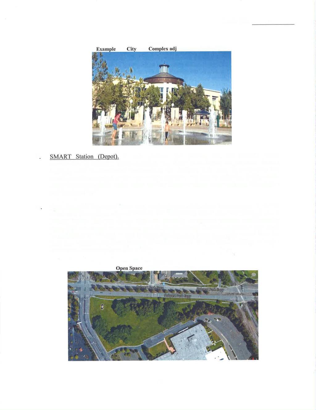
39 Chapter 2: Plan Context Street, Streetscape, and Landscape Character The most striking landscape feature in the PDA is the redwood trees that line the streets and landscaped areas of the community. They form a green corridor along key streets in the PDA, including RPX, State Farm Drive, and Enterprise Drive. Redwood trees also can be found along properties in the PDA, including at the former State Farm office campus, along the SMART rail line, and along U.S Although redwood trees are hardy and distinct, these trees are also water needy and should be balanced with other species of conifer trees, in combination with water-sensitive trees and plants that are native to Rohnert Park. A distinct landscape identity and unifying landscape theme is recommended to support and enhance the identity of Central Rohnert Park and the area s streets and streetscapes. Redwood trees are commonly used along the streets in the PDA, such as along Rohnert Park Expressway, shown here. 2.3 LAND USE AND REGULATORY CONTEXT Land Use and Development Characteristics To support plans for Central Rohnert Park, the PDA is proposed to be organized as five distinct subareas (Figure 2.2). These subareas are described below, from north to south. Triangle Business Subarea. North of Hinebaugh Creek and bounded by U.S. 101to the west and the SMART rail line to the east, this subarea consists of light industrial, warehousing, office, social services, and business-serving retail uses. Characterized by mostly one- and two-story development, this subarea consists primarily of light industrial and office development to the south and more service- and retail-oriented uses in the north. A number of vacant properties and/or functionally obsolete or vacant buildings provide opportunities for building reuse and redevelopment. City Center Subarea. This mixed-use area and civic center destination for Rohnert Park is bounded on the south by RPX, on the north by Hinebaugh Creek, and on the east by the planned SMART rail line. The focus of earlier planning efforts, this subarea has evolved to include the City s public safety building, a library, a community plaza, new residential and professional office uses on small parcels on State Farm Drive and City Center Drive, the existing Padre Town Center shopping center, and access from bike trails along Hinebaugh Creek. The subarea can support new infill growth on vacant sites and redevelopment to replace obsolete, aging, or underused development, including large parking areas. Station Center Subarea. This area housed the State Farm headquarters until State Farm vacated the property in The property is under new ownership, with development plans in progress. Because of the site s close proximity to the SMART rail station, it provides an important redevelopment opportunity for a new transitoriented, mixed-use town center for the city. Central Commercial Subarea. Centered on Commerce Boulevard, between RPX and Enterprise Drive, this area includes several shopping centers that serve as local gathering places. This subarea comprises grocery stores, drugstores, restaurants, professional offices, banks, community services, and senior multifamily apartments. Creekside Neighborhood. South of Enterprise Drive and bisected by the Copeland Creek greenway and multi-use trails, this largely multifamily residential area includes a corner retail center at Enterprise Drive and Commerce Boulevard, multifamily housing accessed from Enterprise Drive and Avram Avenue/Santa Alicia Drive, the existing City Hall, and recreational uses and trails along Copeland Creek. Page 2-3

40 CentralRohnertParkPriorityDevelopmentAreaPlan Draft August 2015 Figure 2.2: PDA Subareas Source: City of Rohnert Park, AECOM, 2015 Page 2-4
41 Chapter 2: Plan Context General Plan Goals The 2000 Rohnert Park General Plan supports future growth within the urban boundaries of the city. The General Plan includes specific policies related to development within the PDA, particularly with respect to development of the City Center. Land use goals applicable to the PDA include: LU-4: Develop the City Center and Sonoma Mountain Village Planned Development as mixed-use, pedestrian-oriented areas. LU-30: Prepare and adopt a City Center Concept Plan to guide development and redevelopment in the City Center area. LU-31: Allow, but do not require mixed- or multi-use development. CD-40: Use an adopted City Concept Plan as the basis for the development character of the area General Plan Designation As shown in Figure 2.3, the General Plan Diagram reflects six land use designations within the PDA: High Density Residential, Office, Regional Commercial, Mixed-Use, Public/Institutional, and Industrial. High Density Residential permits a wide range of housing types, including single-family attached and multifamily developments at densities ranging from 12.1 to 24 units per gross acre. Office includes administrative, financial, business, professional, medical, and public, and supporting commercial uses, with a maximum floor area ratio (FAR) of 1.0. Regional Commercial permits shopping centers, typically comprising department stores, big-box stores, and other retail uses, that attract consumers from outside the city. Mixed-Use accommodates a variety of compatible businesses, stores, institutions, service organizations, and residences in a pedestrian-oriented setting, with a maximum FAR of 1.5 for a mix of nonresidential uses and a maximum FAR of 2.0 for combined residential and nonresidential uses. Public/Institutional provides for schools, government offices, transit sites, religious facilities, and other facilities with a unique public character. Industrial allows for campus-like environments for corporate headquarters, research and development facilities, offices, light manufacturing and assembly, industrial processes, warehousing, storage and distribution, service commercial, and ancillary retail uses, with a maximum FAR of 0.5, but permits up to a 1.0 FAR with discretionary review and approval Zoning Designations The City s Zoning Ordinance is required by state law to be consistent with the General Plan and implements the General Plan. Figure 2.4 shows the existing zoning map for the PDA, which consists of the following zoning districts: Office Commercial (C-O) Regional Commercial (R-C) Industrial (I-L) Industrial/Office Overlay (I-L/O) Mixed-Use (M-U) Open Space Environmental Conservation (OS- EC) Public/Institutional (P/I) High Density Residential Table 2.1 summarizes the purpose and approximate area of the zoning districts and corresponding General Plan land uses. To implement this PDA Plan, some zoning changes will be needed, as outlined in Chapter 4. Page 2-5

42 CentralRohnertParkPriorityDevelopmentAreaPlan Draft August 2015 Figure 2.3: General Plan Diagram Source: City of Rohnert Park, AECOM, 2014 Page 2-6

43 Chapter 2: Plan Context Figure 2.4: Zoning Diagram Source: City of Rohnert Park, AECOM, 2013 Page 2-7
44 CentralRohnertParkPriorityDevelopmentAreaPlan Draft August 2015 Table 2.1: Existing General Plan and Zoning Designations Zoning Designations Office Commercial (C-O) Regional Commercial (C-R) Corresponding General Plan Designations Maximum Residential Density (units/acre) Maximum Intensity (FAR) Maximum Building Coverage (%) Zoned Area (gross acres) Percentage of the PDA (%) Office % % Regional Commercial [1] 60% % Industrial (I-L) Industrial [2] 60% % Industrial/Office Overlay Industrial [2] 60% % (I-L/O) Mixed-Use (M-U) Mixed Use 24 80% % Open Space Environmental Open Space Conservation Environmental (OS-EC) Conservation [3] [3] N/A % Public/Institutional Public/Institutional % % (P-I) High Density Residential (R-H) Notes: High Density Residential % % Total % CMU = Commercial Mixed-Use; FAR = floor area ratio; PDA = Priority Development Area; RMU = Residential Mixed-Use [1] An FAR of 1.5 is allowed for hotel and motel uses in the C-R district. [2] An FAR of 1.0 is allowed for industrial projects, approved by the Planning Commission and meeting criteria set forth in City of Rohnert Park approved design guidelines. [3] A density of 1 unit per acre is allowed in the developable portion of any property within the OS-EC district. Source: City of Rohnert Park, AECOM, 2015 Page 2-8
45 Chapter 2: Plan Context 2.4 CIRCULATION AND CONNECTIVITY Vehicular Circulation As described previously, most vehicular access and circulation in the community is concentrated on the arterial and major collector roadways: RPX, Commerce Boulevard, State Farm Drive, and Golf Course Drive. Beyond this level, the existing network of internal streets in the PDA is discontinuous, with streets terminating either in parking lots of private businesses and properties, at cul-de-sacs, or in circuitous parking lot driveways (Figure 2.5). Recent roadway improvements in the PDA include interchange improvements completed in 2012 at the Golf Course Drive/Wilfred Avenue interchange, which now directly links Golf Course Drive to Wilfred Avenue, underneath U.S In 2013, roadway striping improvements to enhance traffic flow were completed along RPX between U.S. 101 and Commerce Boulevard. As part of that project, a second northbound left-turn lane was constructed at the U.S. 101 northbound off-ramp at Rohnert Park Expressway. In addition, enhanced green bicycle lanes were striped through the interchange between Redwood Drive and Commerce Boulevard to improve bicycle circulation and driver awareness of bicycle facilities. The City also has recently implemented coordinated signal timing along the Golf Course Drive and RPX corridors. U.S. 101 and the SMART rail corridor represent barriers to establishing additional east-west routes in Central Rohnert Park. With respect to the SMART corridor, the California Public Utilities Commission (PUC) regulates at-grade roadway/rail crossings, and is charged with minimizing the number of such crossings to the greatest degree possible. Aside from the challenges to gaining approval for a new road/rail crossing from PUC, the presence of the Foxtail Golf Course along the east side of the tracks and the development pattern of the residential subdivisions beyond that make establishing new roadways east of the PDA infeasible. RPX is currently a major impediment to northsouth bicycle and pedestrian connectivity in the PDA. The character, function, and expectations of this expressway within the PDA would need to change for RPX to support walkability and transitoriented development goals. Changing certain functional characteristics of the roadway, such as reducing the number of vehicular access points, would ensure effective regional access. The roadway s characteristics also create connectivity barriers at the block level, with block lengths approaching 1,000 feet or more. Jaywalking is prevalent along RPX, as evidenced by makeshift pedestrian crossings. The median along the length of RPX provides pedestrian refuge that enables midblock crossings. Because of the extreme distance between signalized crossings, jaywalking will likely persist. Thus, RPX needs to be studied to support additional safe bicycle and pedestrian crossings that will better connect the centers to the north and south Bike Circulation Figure 2.6 identifies the existing and planned bicycle and pedestrian facilities for Rohnert Park. Most streets in the PDA have Class 2 bike lanes. Class 1 trails parallel and cross Hinebaugh Creek and Copeland Creek. These greenway corridors are convenient and well used by both pedestrians and bicyclists, but are not well marked or lit. The Hinebaugh Creek and Copeland Creek trails are largely hidden from view because they are located behind apartment complexes and single-family homes. Landscaping along the trail is overgrown in places, further reducing visibility. These trails are reasonably well connected to the communities east and west of the SMART rail line and connect to the Sonoma State University campus. The community has expressed a need and identified opportunities in the PDA to provide additional connectivity, with better northsouth connections, better maintenance more visibility and security along community trails, and safe crossings of U.S North-south Class I trails are generally lacking, but when constructed, the SMART multi-use path (MUP) will provide an important Class I trail through the community. The MUP is planned for the east side of the railroad tracks, entering the PDA from the south, and crosses to the west side of the railroad tracks at Golf Course Drive/Wilfred Avenue. Pedestrians and bicyclists traveling between the SMART rail station and areas to the south will access the MUP by crossing the tracks at either RPX or Copeland Creek. Page 2-9

46 CentralRohnertParkPriorityDevelopmentAreaPlan Draft August 2015 Figure 2.5: Vehicular Roadways Source: City of Rohnert Park, AECOM, 2013 Page 2-10

47 Chapter 2: Plan Context Figure 2.6: Pedestrian and Bicycle Facilities Source: SCTA, 2013 Page 2-11
48 CentralRohnertParkPriorityDevelopmentAreaPlan Draft August 2015 The MUP will provide a north-south Class I bicycle route that intersects the existing east-west trails along Copeland Creek and Hinebaugh Creek. The MUP also will help connect the Sonoma Mountain Village PDA to the city s bicycle network and provide a Class I connection under U.S. 101 at the northern edge of the city, at Redwood Drive, north of Golf Course Drive Pedestrian Circulation Sidewalks are generally continuous within the PDA, except along frontages on two undeveloped parcels one on Commerce Boulevard west of Professional Center Drive and another on State Farm Drive north of Professional Center Drive. Signalized intersections of city streets have marked crosswalks on all intersection legs and pedestrian buttons, with some providing countdown signals. For pedestrian safety, signalized intersections at freeway ramps have crosswalks on only two or three legs. High-visibility crosswalk markings and pedestrian crossing signs are provided at the intersection of State Farm Drive and City Center Drive, where adjacent mixed-use and civic functions generate higher levels of pedestrian activity Transit SMART Commuter Rail The SMART commuter rail system is a 70-mile rail line, planned to run from Cloverdale in Sonoma County to Larkspur, where the Golden Gate Ferry connects Marin County with San Francisco. Along this path, located along the historic Northwestern Pacific Railroad line, SMART will have 15 stations along the major population and job centers in Sonoma and Marin County, including Rohnert Park. The system will operate an estimated 14 round-trip trains on weekdays and four round-trip trains on weekends. Headways during morning and evening commute periods will be 30 minutes, with longer headways during midday, evening, and weekend periods. SMART is planning to initiate rail service in late 2016 on its initial operating segment, which will run from North Santa Rosa to the Downtown San Rafael Transit Center. The SMART rail station in Rohnert Park is planned south of RPX. The station will include a park-andride lot with approximately 130 vehicle parking spaces, bicycle parking including lockers, an elevated train platform, and pedestrian pathways and access from surrounding streets. Vehicular access to the station will occur via the Enterprise Drive/Seed Farm Drive intersection. A vehicular connection to RPX has been discussed as a possible unsignalized eastbound right-in/right-out connection or a new signalized intersection. However, the proximity of the resulting intersection to the SMART rail crossing on RPX presents operational and safety challenges to this scheme. Bus Service Bus routes with direct connections to the SMART station platform have not been finalized at this time, but several options have been explored, including drop-offs near the platform on RPX and/or State Farm Drive and/or direct connections into the SMART station parking area. If the Station Center subarea (former State Farm campus) is developed, bus drop-offs could occur at that site as well. Numerous transit lines currently operate in the PDA. Sonoma County Transit and Golden Gate Transit provide bus service. Sonoma County Transit (SCT) is the principal transit service in Rohnert Park, providing daily local and intercity service. SCT local routes 10, 12, and 14 provide transit access to destinations on both the east and west sides of U.S Each local route operates with approximately 90- to 120-minute headways between 6:00 a.m. and 6:00 p.m. on weekdays, and 9:30 a.m. and 3:00 p.m. on Saturdays; no local service is provided on Sundays. SCT Routes 26, 44, and 48 provide intercity service to Rohnert Park. Route 26 provides service between Rohnert Park and Santa Rosa between approximately 6:30 a.m. and 5:30 p.m., with two runs 1 hour apart for the morning and evening commutes and one run during the middle of the day. Routes 44 and 48 provide service between Petaluma and Santa Rosa. Routes 44 and 48 operate with approximately 40- to 120-minute headways between 6:30 a.m. and 8:30 p.m. on weekdays, with a combined headway of minutes. On weekends, SCT Routes 44 and 48 operate with approximately 2- to 4-hour headways between 7:00 a.m. and 8:00 p.m. and a combined headway of 1 2 hours. Page 2-12

49 Chapter 2: Plan Context Figure 2.7: SMART Commuter Rail Service Source: SMART, 2015 Page 2-13
50 CentralRohnertParkPriorityDevelopmentAreaPlan Draft August 2015 The nearest SCT bus stops serving the PDA are located at RPX and Commerce Boulevard, Raley s Town Center on State Farm Drive between RPX and Enterprise Drive, the Senior Center on Hunter Drive, and Chase Bank on RPX between Commerce Boulevard and State Farm Drive. On weekdays, the PDA is served by SCT Routes 10, 12/14, 26, and 44/48. On weekends, the PDA is served by SCT Routes 10/12 and 44/48. All SCT buses are wheelchair lift equipped and can transport two wheelchair passengers at a time. SCT allows bikes on all of its buses. Buses are equipped with a front-loading bike rack that accommodates either two or three bicycles. When the frontloading rack is full, bus drivers may allow up to two bikes inside the bus. Dial-a-Ride Paratransit Service Dial-a-ride, also known as Paratransit or door-todoor service, is available for those who are unable to independently use the transit system because of physical or mental disability. Sonoma County Paratransit is designed to serve the needs of individuals with disabilities in Sonoma County. Service days are Monday through Friday from 5:00 a.m. to 11:00 p.m., and Saturday and Sunday from 7:00 a.m. to 9:00 p.m. Golden Gate Transit (GGT) provides daily interregional service along the U.S. 101 corridor between Santa Rosa and San Francisco. Route 72 provides weekday commuter service between Santa Rosa and San Francisco, with a southbound stop at RPX and northbound at U.S. 101 and RPX. Route 72 operates with 20- to 30-minute headways on weekdays only, with service between Rohnert Park and San Francisco. Routes 70/71/80 and 101 operate daily along the U.S. 101 corridor between Santa Rosa and San Francisco, with a stop on Commerce Boulevard at RPX. On weekdays and weekends, GGT Route 70/71/80 and 101 have 1-hour headways. All GGT buses are handicap accessible and equipped with a front-loading bike rack that accommodates either two or three bicycles. On express buses, storage space for bicycles is provided under the coach. Park-and-ride lots serving GGT and SCT users are provided along the U.S. 101 corridor. A 150-space lot exists on the western side of the RPX interchange and a 180-space lot is provided on the eastern side. Sidewalks connect the park-and-ride lots to pedestrian facilities along RPX. In the northern part of the PDA, a 180-space lot is located on Roberts Lake Road, just north of Golf Course Drive. Page 2-14
51 Chapter 2: Plan Context 2.5 MARKET OVERVIEW Employment Conditions and Job Trends According to U.S. Census Local Economics Dynamics data, there were approximately 5,300 jobs in the PDA in 2002, accounting for 39% of all employment in Rohnert Park. By 2011, however, the PDA had approximately 2,000 fewer jobs. This decrease occurred in part because of the departure of two major employers in Rohnert Park within the past 10 years. Agilent Technologies closed the company s Rohnert Park manufacturing plant in 2005 and State Farm Insurance closed its Rohnert Park office in The resulting employment losses from these two large employers are reflected in the industry data, which show the greatest employment losses in Rohnert Park between 2002 and 2011 occurring in the finance and insurance industry (with a loss of 1,700 jobs) and the manufacturing industry (with a loss of 1,400 jobs). In contrast, employment in the educational services industry doubled in Rohnert Park between 2002 and 2011, making this the new largest employment industry in Rohnert Park and accounting for 20% of all employment in Rohnert Park in According to the City s Comprehensive Annual Report for the fiscal year Sonoma State University was the largest employer in the city in 2012, with 1,000 employees, followed by the Rohnert Park/Cotati Unified School District, with 492 employees. Other significant industries in the PDA include health care and social services, accounting for 19% of PDA employment, and retail trade and finance and insurance, both accounting for approximately 11% of employment, as summarized in the Market Conditions Strategy Memo. Based on unemployment data for Rohnert Park between 2000 and 2012, unemployment in Rohnert Park generally varied between 3% and 4% between 2000 and 2007 and peaked in 2010, reaching 10.3%. Unemployment decreased to 6.9% in 2013, suggesting a steady but ongoing recovery from the recent recession Office Market Conditions In Sonoma County, Santa Rosa serves as the primary node for office-based employment, with approximately 4.3 million square feet of office space, according to data provided by Cornish & Carey Commercial, a commercial brokerage. Petaluma and Rohnert Park have smaller inventories of office space, totaling approximately 1.3 million square feet in Rohnert Park and 2.0 million square feet in Petaluma. Within the PDA, office uses consist largely of service commercial tenants including financial, real estate, and medical services. Table 2.2 shows current office market conditions in Rohnert Park, Santa Rosa, and Petaluma. As shown, more than one-third (38%) of office space in Rohnert Park was vacant as of the second quarter of Table 2.2: Office Market Overview, Second Quarter 2013 Inventory Vacancy Net Absorption Average Asking Location (sq. ft.) Rate Q (sq. ft.) Rent (per sq. ft./mo) Rohnert Park 1,345, % (16,657) $1.62 Class A 655, % 6,005 $1.74 Class B 689, % (22,662) $1.37 Petaluma 2,001, % (11,235) $1.84 Class A 1,271, % (8,780) $1.94 Class B 730, % (2,455) $1.67 Santa Rosa 4,285, % 23,676 $1.65 Class A 1,858, % (53,702) $1.80 Class B 2,426, % 77,378 $1.47 Sources: Cornish & Carey Commercial Newmark Knight Frank, BAE; Page 2-15
52 CentralRohnertParkPriorityDevelopmentAreaPlan Draft August 2015 Although the office vacancy can be attributed in large part to closure of the Rohnert Park State Farm office (adding approximately 320,000 square feet of vacant office space), the market for office space in Rohnert Park is limited. The average asking rent for office space in Rohnert Park in the second quarter of 2013 was $1.62 per square foot per month, lower than the average in Petaluma ($1.84 per square foot per month) and Santa Rosa ($1.65 per square foot per month). The future market for office space in Rohnert Park and in the PDA may improve as the office market continues to recover in primary Bay Area office markets such as San Francisco and San Jose, pushing demand to secondary and tertiary markets in the region, and with enhanced transit improvements resulting from the planned SMART station. However, the large existing inventory of vacant office space in the city is likely to limit the potential for new office development in the PDA until the vacant inventory is absorbed or redeveloped or removed from the market Retail Market Conditions Data on the retail real estate market in Sonoma County were provided by commercial brokerage firms Keegan & Coppin and Terranomics. Keegan & Coppin provides inventory and vacancy data for individual cities in Sonoma County and includes a larger inventory of retail space, but does not provide absorption or rental rate data. Terranomics inventories a smaller subset of properties (generally shopping centers of 50,000 square feet or more) and does not provide data for individual cities in Sonoma County, but does provide data on absorption and rental rates at the county level. Table 2.3 presents retail real estate market data. As with the office market, the primary node of retail activity in Sonoma County is in Santa Rosa. However, Rohnert Park serves as a subregional node for retail activity. According to Keegan & Coppin, Sonoma County had 17.9 million square feet of retail space in the second quarter of 2013, 44% of which was in Santa Rosa. The retail inventory in Rohnert Park totaled 3.4 million square feet, accounting for 19% of the retail inventory in the county. The retail real estate market in Sonoma County reflects the continuing negative effects of the recession, including ongoing high unemployment and underemployment on retail spending in the area. Although occupancy rates are strong, recent negative absorption and low asking rents suggest limited demand for retail real estate in the county. In the second quarter of 2013, the retail vacancy rate was relatively low at 5.1% countywide. The vacancy rate in Rohnert Park was higher at 8.8%, but still in a relatively healthy range. Table 2.3: Retail Market Overview, Second Quarter 2013 Q Net Average NNN Inventory Vacancy Absorption Asking Rent (per Location (sq. ft.) Rate (sq. ft.) (a) sq. ft./mo) (a) Rohnert Park 3,356, % N/A N/A Petaluma 2,764, % N/A N/A Santa Rosa 7,889, % N/A N/A Elsewhere in Sonoma County 3,925, % N/A N/A Sonoma County Total 17,935, % (108,092) $1.43 (a) Net absorption and average asking rent figures were provided by Terranomics, which tracks a smaller number of properties than Keegan and Coppin and does not provide data for individual cities in Sonoma County. All other data are provided by Keegan and Coppin. Sources: Keegan and Coppin, Terranomics, BAE; Page 2-16
53 Chapter 2: Plan Context Existing retail spending patterns in Rohnert Park indicate that the city is adequately served by community-serving retail uses. Although a detailed leakage analysis would be needed to fully analyze potential retail leakage and injection in Rohnert Park, these data suggest that Rohnert Park residents are generally able to meet basic retail needs with the offerings supplied within the city limits, and that some residents living elsewhere in Sonoma County regularly go to Rohnert Park for purchases. In the PDA, there is a cluster of retail shopping centers along RPX between U.S. 101 and State Farm Drive. Because of this concentration of retail centers, the PDA is particularly well served by community-serving uses, such as grocery stores, banks, fitness centers, and restaurants. Grocery stores within the PDA include Raley s, Safeway, Grocery Outlet, and La Perla Market, a grocery store specializing in Mexican food products Housing Conditions According to building permit data provided by the U.S. Census Bureau, building permit activity in Rohnert Park and Sonoma County decreased sharply in 2006, and has not yet returned to previous levels. Rohnert Park issued permits for an average of 188 units per year between 2003 and 2005, mostly in buildings with five or more units. Since 2006, Rohnert Park has issued building permits for a total of only 24 units, all of which were permitted in These data indicate that residential development activity in Rohnert Park has not returned to levels seen before the recession. For-Sale Housing Home sale data were compiled from DataQuick, which collects data from the Sonoma County Assessor. In 2005, the median home sale price in Rohnert Park was approximately $515,000 (Table 2.4). In 2012, the city s median sale price was $249,000, approximately 50% to 60% of the 2005 median. More recent data indicate that home prices in Rohnert Park overall have increased in recent months, similar to price increases in many locations throughout the Bay Area, suggesting that the local housing market is beginning to recover. In Rohnert Park, the median home sale price was $320,000 in July 2013, up 28% from $250,000 in July Recent sales of single-family homes in Rohnert Park have consisted largely of units with three or more bedrooms, with sale prices between $300,000 and $450,000. In comparison, condominiums recently sold in Rohnert Park typically had a lower sale price and a smaller number of bedrooms. Condominiums sold in Rohnert Park between February and July 2013 had a median sale price of $184,750, and 94% had either two or three bedrooms. Almost all (96%) sold for less than $300,000. These current condominium sale prices are not conducive to new condominium construction. However, it is anticipated as the forsale market recovers in Sonoma County and across the Bay Area, the market for transit-oriented forsale product types is likely to improve, as evidenced by recent selling trends in other infill areas in the Bay Area. Rental Housing According to figures provided by RealFacts, which collects data on multifamily rental developments with 50 units or more, the multifamily rental market in Rohnert Park consists of fairly small units on average. Among properties in Rohnert Park that are included in the RealFacts inventory, half are onebedroom units. The typical square footage of these units is also fairly small, averaging less than 900 square feet for most unit types. To a greater extent than the for-sale market, the rental residential market in Rohnert Park has shown indications of a recovery in recent years, with rents higher than 2005 levels, as indicated by data from RealFacts. Average rents decreased in Rohnert Park between 2008 and 2010, but have increased quickly in more recent years (Table 2.5). Overall, average rents increased by 20% between 2005 and 2013, reaching $1,263 by the second quarter of Occupancy rates in rental properties in Rohnert Park have also seen similar trends, with occupancy rates reported by RealFacts to vary between 93% and 98% in Occupancy rates higher than 95% typically indicate a shortage of available rental housing on the market, which suggests that there could be a market for additional rental housing in Rohnert Park once rents rise sufficiently to justify new development. Page 2-17
54 CentralRohnertParkPriorityDevelopmentAreaPlan Draft August 2015 Table 2.4: Median Home Sale Prices, $700,000 $600,000 $500,000 $400,000 $300,000 $200,000 $100,000 $ July 2103 Location July 2103 Rohnert Park $515,000 $484,500 $415,000 $310,000 $250,000 $260,000 $236,500 $249,000 $320,000 Santa Rosa $540,000 $525,000 $487,000 $330,000 $280,000 $294,000 $270,000 $295,000 $381,000 Petaluma $615,000 $615,000 $575,000 $435,000 $392,000 $395,000 $355,000 $372,000 $474,500 Sonoma County $562,500 $545,000 $505,000 $365,000 $310,000 $320,500 $297,000 $320,500 $424,250 Sources: DataQuick, 2013; BAE, Rohnert Park Santa Rosa Petaluma Sonoma County Q Net Average NNN Inventory Vacancy Absorption Asking Rent (per Location (sq. ft.) Rate (sq. ft.) (a) sq. ft./mo) (a) Rohnert Park 3,356, % N/A N/A Petaluma 2,764, % N/A N/A Santa Rosa 7,889, % N/A N/A Elsewhere in Sonoma County 3,925, % N/A N/A Sonoma County Total 17,935, % (108,092) $1.43 (a) Net absorption and average asking rent figures were provided by Terranomics, which tracks a smaller number of properties than Keegan and Coppin and does not provide data for individual cities in Sonoma County. All other data are provided by Keegan and Coppin. Sources: Keegan and Coppin, Terranomics, BAE; Page 2-18
55 Chapter 2: Plan Context Table 2.5: Rental Market Housing Trends, Average Monthly Rent $2,000 $1,800 $1,600 $1,400 $1,200 $1,000 $800 $600 $400 $200 $ % 98.0% 97.0% 96.0% 95.0% 94.0% 93.0% 92.0% 91.0% 90.0% Average Occupancy Rate Studio 1BR/1BA 2BR/1BA 2BR/2BA 3BR/2BA All Unit Types Note: (a) Data captures rental housing complexes with more than 50 units in Rohnert Park. Sources: RealFacts; BAE, Page 2-19
56 CentralRohnertParkPriorityDevelopmentAreaPlan Draft August 2015 This page intentionally left blank. Page 2-20
.")

57 CHAPTER 3 VISION AND PLAN CONCEPTS 3.1 CHAPTER OVERVIEW This chapter provides an overview of the community vision and preferred plan concepts for the Central Rohnert Park Priority Development Area (PDA). The information presented here reflects input received from the community and stakeholders in workshops and meetings conducted during the planning process. This chapter summarizes the community s placemaking priorities, land use and development concepts, circulation and connectivity concepts, and open space concepts that serve as the development framework for Central Rohnert Park. Subsequent chapters of this PDA Plan provide details on how to carry forth individual elements and themes of this vision. 3.2 CENTRAL ROHNERT PARK PLACEMAKING PRIORITIES As summarized below, several placemaking priorities emerged from the project visioning process and serve as key themes for the PDA. 1. Create a Downtown for Rohnert Park Participants in the planning process stated that there is no center in the city. They described their vision for Downtown as follows: Distinctive. Downtown is designed with quality architecture, landscaping, and public spaces. Downtown should not be the flavor of the day, but rather reflect the unique sense of place and traditions and values in Rohnert Park. Compact and Walkable. Downtown is a compact, walkable district with high-density residential and commercial development. It is pedestrian- and transit-oriented and accessible from the Sonoma-Marin Area Rail Transit (SMART) rail station and the surrounding community. Active and Mixed-Use. Downtown is an active place, with a mix of housing options; specialty shopping; food and entertainment uses; parks, plazas, and recreation; transit services; and public amenities. Like other downtowns, it should balance parking demand with a creation of a vibrant place. Patrons can park in one place and walk to Downtown and other areas of the community. Accessible. Downtown is easily accessible by car, bikeway, pedestrian paths, and transit. It provides services and amenities for the diverse population and users in the community, including local residents, employees, students, and visitors. Business-Oriented. Downtown is an economic center and thriving place of business, where businesses (shops and services) choose to locate. Design Downtown with quality architecture and public spaces. Activate commercial main streets with landscaping and wide sidewalks. Page31

58 CentralRohnertParkPriorityDevelopmentAreaPlan Draft August Support Connections in Central Rohnert Park 3. Enhance the District Identity of Central Rohnert Park Establish a Transit District Providing Intermodal Bus and Commuter Rail Services. The community s current transit orientation, with buses clustered in several locations near the SMART rail station, supports the establishment of a transit district, where the timing of transit services is coordinated with SMART rail service. The central location of the SMART station should be leveraged to support foot traffic and convenient circulator service through the Downtown and adjacent shopping centers. Improve Local Access. Many of the city s arterial and collector roadways are designed to accommodate efficient vehicular flow. These roadways, however, need to be designed to also support safe community access, particularly bike and pedestrian circulation, with safe street crossings and slowing traffic speeds through the heart of the Downtown area; improved parking area circulation; and other bike and pedestrian amenities. Expand Regional Access. The PDA Plan promotes roadway enhancements; transit, bike, and pedestrian connections within and outside the PDA to the SMART rail station and other community destinations regional parks, open space, and trails. The Plan supports completion of regional bike trail system gaps through the community to connect residential neighborhoods in the city to the SMART station and other destinations in Central Rohnert Park. Establish a Uniform Streetscape and Landscape Theme. A common landscape theme is used to bring identity to Central Rohnert Park and establish unique districts such as, Downtown, within the community. Landscape and streetscape features unify and help to establish the unique character and conditions of the community, drawing from the native landscape features of the Santa Rosa Plain. Strengthen the Architectural Character in the Community. Consistent with the character of newer developments in the city, a mix of architectural styles common to the Sonoma County region a blend of traditional, Mediterranean, Tuscan, and rustic or rural design elements and sustainable development features are encouraged in Central Rohnert Park. Provide Gateway and Wayfinding Signage. A gateway and wayfinding signage program for Central Rohnert Park, coordinated with streetscape and landscape themes and materials used in the community supports the unique sense of place of Downtown and Central Rohnert Park as the center of community life in Rohnert Park. Coordinate gateway and wayfinding signage with landscape themes in the PDA. Page 3-2

59 Chapter 3: Vision and Plan Concepts 4. Green the Community Expand and Enhance Established Landscaping and Open Space Features. Existing open space and landscape features, including the creek open space corridors and trails; street corridors, with views to the Sonoma Mountains; and landscaped greenbelts at the edge of the community are existing assets that are integrated in the landscape and open space network of the community, as a unique feature enhancing the livability and identity of Central Rohnert Park and expanding the green infrastructure in the city. Support the Creation of a Seamless Open Space Network Connecting the Region. Central Rohnert Park is a stop providing for the recreational needs of the community along a seamless open space and bike and pedestrian trail network that will connect the City to the Sonoma and Marin County regions along the SMART multi-use path. 3.3 THE PLAN Central Rohnert Park is envisioned as the social and economic heart of the city. The PDA already supports a mix of shopping, employment, residential, and mixed-use development, and a walkable city center. Arrival of the SMART rail system to Rohnert Park provides additional opportunities to create a walkable Downtown for the city, adjacent to transit. Plan concepts for Central Rohnert Park conceive of five subareas, and a distinct Downtown district, with unique characteristics as summarized in the following sections. These subareas provide the commercial and service needs of the community and are envisioned to be developed as distinct community places in and of themselves, connected by an improved city street grid and transit, bike, and pedestrian facilities. Additionally, formation of a Downtown district is envisioned to knit together the commercial heart of the PDA, near the SMART rail station platform. Figure 3.1 illustrates the key features and land use concepts for subareas; a proposed Downtown district; and the circulation and park and open space design framework intended to connect the PDA internally with adjacent community areas. Subarea concepts for land use and development, circulation, open space, and other characteristic features follow in this section. Encourage the development of new parks, plazas, and open space connections. Promote Sustainable Design. Sustainable landscaping and building design best practices, including repurposing/reusing existing buildings; orienting development for passive heating and cooling opportunities; employing climate-appropriate landscaping; and demonstrating low-impact development features, such as bioretention planters, permeable pavers, and green roofs are encouraged and rewarded. Page 3-3

60 CentralRohnertParkPriorityDevelopmentAreaPlan Draft August 2015 Figure 3.1: Central Rohnert Park Plan Concept Source: AECOM, 2015 Page 3-4

61 Chapter 3: Vision and Plan Concepts 3.4 SUBAREA LAND USE AND DEVELOPMENT CONCEPTS TRIANGLE BUSINESS SUBAREA The Triangle Business subarea, located north of Hinebaugh Creek, has the potential to be an important business and employment center for Rohnert Park, with frontage both along U.S. 101 and the SMART rail line. Consisting of office, light industrial, and warehouse space, this subarea is envisioned to transform into a more cohesive, mixed-use business district through infill development, redevelopment of underused sites, building reuse, and landscape improvements. Redevelopment of private properties in this subarea should be supported by public roadway and district wayfinding improvements. The southern end of the Triangle Business subarea includes a 9-acre parcel zoned Mixed- Use. Approximately half of this parcel has been developed as a self-storage facility and the other half of the parcel remains vacant. The mixed-use zoning permits residential or commercial development, but high-density residential development is most likely to occur on the property. Priorities for this subarea are to support existing businesses at affordable rents; attract diverse new tenants, higher paying office jobs, new retail and service uses, and a high-quality hotel that could benefit from freeway presence on U.S. 101; and provide opportunities to creatively reuse the existing buildings for new uses such as a brewery, artist studio, or flexible mixed-use spaces. To reduce the amount of impervious surface in this subarea, sustainable stormwater management approaches and open space and paseos should be encouraged as new development or redevelopment occurs. Within one-half mile of the planned SMART rail station, street improvements along major roadways in the subarea are recommended to improve bike and pedestrian access and parking and enhance the landscape character and identity of the subarea, as described in Chapters 4 and 5. coordination with private property owners and businesses in the subarea, to address subarea improvement opportunities. These plans should build from the framework established in this PDA Plan, to address: streetscape improvements that enhance the subarea s identity and support bike and pedestrian access and connections; the potential for shared-use driveways and parking between adjacent properties to reduce curb cuts on the street and support streetscape, circulation, and open space improvements; coordination with private property owners and businesses to improve the organization of driveways, walkways, parking, and open space connections; façade and landscape improvements that contribute to the public identity of the community; and opportunities to reduce overall impervious surface area through streetscape and landscape improvements and development of common open space as properties redevelop in the subarea. Reuse buildings to support recreational activities in the community. Beyond the concepts of this PDA Plan, this subarea is recommended for additional study, in Page 3-5
, on the north by Hinebaugh Creek, and on the east by")


62 CentralRohnertParkPriorityDevelopmentAreaPlan Draft August CITY CENTER SUBAREA This mixed-use area and civic center destination for Rohnert Park is bounded on the south by Rohnert Park Expressway (RPX), on the north by Hinebaugh Creek, and on the east by the planned SMART rail line. The City Center subarea is anchored by a civic plaza and uses that include a library and the City s public safety building on one end and a neighborhood commercial center on the other. Vacant and underused properties in the subarea have potential to support compact infill development and redevelopment on small parcels that can support smaller businesses and tenants, inline office and service tenants, and mixed-use development and lofts that complement the existing character of the City Center. Additionally, bike and pedestrian circulation improvements should be implemented to connect the subarea to employment uses in the north, eastwest community creek trails along Hinebaugh Creek, and the SMART stop to the south. Consider future opportunities to relocate City Hall to complete the Civic Center. Activate commercial areas with small plazas and seating places. Link subareas and centers to the adjacent neighborhoods via pedestrian paths. The City Center subarea has is envisioned as a walkable, self-sufficient community in proximity to the SMART rail station. Apart from portions of Civic Center Drive, the existing street grid within this suabarea is not well defined, but expected to change over time as new development occurs. Along Civic Center Drive, broad sidewalks and landscaped tree wells create a pleasant walking experience that has started to establish the framework for a walkable, mixed-use, pedestrianoriented subarea. These improvements should be supported by new uses that build on the area s neighborhood character and continues to refine the urban street grid in the City Center. Encourage mixed-use lofts with residential uses above neighborhood retail. Much of the City Center subarea already exhibits the qualities desired for Downtown (e.g., walkability, activity centers, plazas, street furniture). These features and qualities are envisioned to be extended south to expand and establish a larger Downtown district for Rohnert Park, as further described in Section Page 3-6


63 Chapter 3: Vision and Plan Concepts STATION CENTER SUBAREA The Station Center subarea is envisioned to complement the progress in the City Center by establishing a Downtown destination in Rohnert Park for dining, entertainment, retail shopping, services, and recreational activities. The Station Center subarea redevelops the State Farm office campus and relocates the City corporation yard to provide a retail-focused Downtown area that serves the local community and draws regional visitors through access along SMART. This Downtown area includes or is adjacent to transitsupportive housing, office, civic, and other community-oriented uses. green, a transit plaza north of the SMART rail platform, and the potential for bus and passenger drop-off and transfer to the SMART station. Line shops within the subarea along a commercial main street. The southern half of the Station Center subarea is envisioned to be developed with a variety of highdensity multifamily housing and residential mixeduse development, located within a cohesive residential community, connected by walking paths. Establish the Station Center subarea as a compact, walkable community. The Station Center subarea incorporates a walkable street grid and continuous bike, pedestrian, and open space connections, integrated with the existing park/open space system in the city. This subarea preserves the existing, mature redwood trees, encircling the property and incorporates trails and paths that connect the community to the SMART station, to uses and destinations in the community, and other regional open space and trail systems. The north portion of the Station Center subarea is part of the Downtown district, envisioned to extend north across RPX to include the City Center and west across State Farm Drive to include portions of the Central Commercial subarea. Within the Station Center, the Downtown district includes a commercial main street lined with shops, a central community Provide a diversity of housing types and styles with shared common space. To improve connectivity, at-grade intersection crossing improvements include pedestrian refuges, pedestrian-activated crosswalk signals, and rail crossing safety arms. Improvements support safe pedestrian crossings of RPX, State Farm Drive, and the SMART rail corridor. A bike/pedestrian bridge overcrossing of RPX should be constructed to connect the Downtown Page 3-7


64 CentralRohnertParkPriorityDevelopmentAreaPlan Draft August 2015 district, between the Station Center and City Center subareas CENTRAL COMMERCIAL SUBAREA Bounded by and accessed via Commerce Boulevard, State Farm Drive, and Enterprise Drive, the Central Commercial subarea includes the grocery stores, post office, banks, and restaurants that support the daily retail and service needs of the community. Although primarily auto-oriented, the Central Commercial subarea is located near existing residences in the Creekside Neighborhood and planned new residences in the Station Center subarea. directional signage that facilitates community access. Support development of local gathering places in commercial shopping centers. The northern portion of the Raley s shopping center is envisioned as part of the Downtown district, further described and identified below in Section Within this area of the community, streetscape improvements and new infill growth is needed to shape the streetscape character and appearance of the Downtown district on both sides of State Farm Drive. Provide safe pedestrian passage connecting shopping areas to adjacent neighborhoods. This subarea is composed of several large shopping centers that are separated by busy roadways and not well connected to one another or internally for pedestrian mobility. The Raley s and Safeway shopping centers are located back to back and, though adjacent lack safe pedestrian facilities. A key challenge is to support connectivity from these shopping centers to the nearby community and reduce reliance on the automobile for short internal trips within the PDA. As redevelopment of these shopping centers occurs, pedestrian facilities and amenities should be added to support a more pedestrian-friendly shopping experience and improve local community access by bicycle or foot. Such improvements could include parking lot landscaping and shading; outdoor seating, dining, or gathering places; new defined vehicular routes and pedestrian walkways; bicycle facilities; and The subarea should also be improved with safe vehicular access along Commerce Boulevard, State Farm Drive, and surrounding area roads and safe bike and pedestrian access to the SMART rail station and adjacent neighborhoods. Improve community/pedestrian access n large commercial parking lots. Page 3-8


65 Chapter 3: Vision and Plan Concepts CREEKSIDE NEIGHBORHOOD The Creekside Neighborhood, located south of Enterprise Drive, is a multifamily residential area bisected by the Copeland Creek greenway. This subarea includes City Hall and a corner shopping center at the intersection of Enterprise Drive and Commerce Boulevard. Although the Creekside Neighborhood is largely built out, portions of this subarea are within a 5- to 10-minute walking distance of the SMART rail station, making the neighborhood accessible by foot or bicycle to transit and providing a local built-in population to patronize the shops and services in the commercial and mixed-use subareas north of the neighborhood. and overall quality. Trail entrances from Enterprise Drive should be enhanced with signage and other improvements. Include neighborhood-oriented infill and streetscape enhancements in the Creekside neighborhood. The Creekside neighborhood has potential for some residential and commercial infill growth, but remains a primarily multifamily residential area. Continuing to improve Copeland Creek as a back yard open space amenity and regional trail connector for the community is a key priority of this subarea. Bike and pedestrian trail access enhancements, as well as lighting, trail signage, and regular maintenance are envisioned to maintain and improve the creek corridor as a local amenity and support safe access to the SMART multi-use path and other destinations in the community. The entrances to Copeland Creek are currently not well marked and are largely hidden from view. Enhancements to trail intersections on Commerce Boulevard and Seed Farm Drive would improve their visibility, wayfinding, safety, DOWNTOWN DISTRICT As described in the community priorities, a key theme that has emerged is the need for a Downtown in the PDA. A Downtown District Amenity Zone overlay is proposed to realize the vision for Downtown as... a distinct place and vibrant mixed-use commercial core; a compact and walkable environment; and transit-oriented district that is internally connected across RPX and State Farm Drive and accessible from the SMART station and surrounding neighborhoods. Downtown should possess the following qualities, as introduced in Chapter 1: Enhance the Copeland Creek corridor as an important local community resource. A distinct and cohesive design character that respects the local Sonoma County landscape and the artistic, cultural, and sustainability values of the community. Page 3-9
 uses.")
66 CentralRohnertParkPriorityDevelopmentAreaPlan Draft August 2015 A pedestrian-oriented development pattern, with walkable streets and blocks, compact building footprint, and generous open space. A mix of uses, with emphasis on lifestyle and specialty retail; entertainment; urban-style living options; public space; and transitsupportive (job, service, and retail) uses. Public space catering to the diverse segments of the community. A new Downtown District Amenity Zone overlay is proposed to implement the Downtown District, as addressed in greater detail in Chapter 4, Land Use and Development. 3.5 CIRCULATION CONCEPTS Multi-modal transportation options (vehicular, transit, bicycle, and pedestrian travel modes) through a network of sidewalks, bicycle and pedestrian paths, and landscaped streets and corridors weave and connect the PDA. Bicycle and pedestrian paths provide north-south and east-west connections to the SMART rail station, creek corridors, and residential neighborhoods in the community. These paths connect to regional open space and trail systems and complete the community s circulation network. Buses and a community circulator are provided and timed to coordinate with SMART rail service to serve commuters and transport them to employment centers, subareas, and other destinations in the community such as Sonoma State University and Graton Rancheria Casino. Support development of continuous bicycle and pedestrian facilities as an alternative to vehicular travel modes. Page 3-10

67 Chapter 3: Vision and Plan Concepts 3.6 Park and Open Space Concepts Open space through the community currently comprises the east-west Copeland Creek and Hinebaugh Creek open space corridors, redwood tree-lined landscaped corridors on major roadways, landscape open space buffers along the SMART rail line and U.S. 101, and community spaces on private property. The regional open space and trail system for the PDA is established by the creek corridors; SMART multi-use path; and landscape corridors on the major roadways in the PDA, including Commerce Boulevard, State Farm Drive, RPX, and Enterprise Drive. New park, open space, and trail connections focus on completing connections to the regional open space network and providing active and passive recreational facilities to serve the variety of needs and activities in the community. Park and open space features envisioned in the PDA include unified and landscaped roadway corridors with consistently spaced shade trees; new north-south and east-west landscape paseos and trails, connecting to the SMART multi-use path and regional trail networks; and new or improved public and private parks, plazas, and gathering spaces that contribute to the public character and livability of streets and community areas in the PDA. Support development of continuously landscaped roadway corridors to improve the public character of the community. Page 3-11
68 CentralRohnertParkPriorityDevelopmentAreaPlan Draft August 2015 This page intentionally left blank. Page 3-12
 specifically, its land use designations, associated development")
.")
 rail line.")

69 CHAPTER 4 LAND USE 4.1 CHAPTER OVERVIEW This chapter describes the land use framework for the Central Rohnert Park Priority Development Area (PDA) specifically, its land use designations, associated development standards, and development potential. Land use and development standards implement the preferred plan concepts, introduced in Chapter 3. A variety of land use, development, open space, and circulation conditions are present in Central Rohnert Park, as described in Chapter 2 (Plan Context). The PDA has been organized into five distinct mixed-use subareas, which form the basis for evaluating characteristic uses in the community: Triangle Business subarea, a business subarea transitioning from industrial uses, with frontage along U.S. 101 and the Sonoma-Marin Area Rail Transit (SMART) rail line. City Center subarea, a current civic center and neighborhood-oriented mixed-use area, with potential for infill growth that complements the existing land use and circulation framework in the area. Station Center subarea, a new mixed-use, transit-oriented community adjacent to the SMART rail station, with a town center, diverse housing, parks, open space, and gathering places. Central Commercial subarea, the City s primary retail and service shopping area, including grocery stores, a post office, banks, and restaurants. Creekside Neighborhood subarea, an established multifamily residential neighborhood area, centered along Copeland Creek. Subarea Character and Emerging Roles The Triangle Business subarea is a mixed-use employment center with freeway presence near the SMART rail line. The City Center subarea is emerging as a civic center hub and walkable neighborhood. The former State Farm campus in the Station Center subarea is an opportunity site for a new town center in the city. The Downtown District is to be a central retail and entertainment core for the PDA that is envisioned as pictured. The Central Commercial subarea is a cluster of centers providing retail and services to the community. The Creekside subarea is a multifamily residential area centered on Copeland Creek. Page41
70 CentralRohnertParkPriorityDevelopmentAreaPlan Draft August 2015 Subareas are intended primarily to help divide the PDA Plan into meaningful study areas, but are not intended to establish regulatory controls. Established General Plan designations and zoning districts, with some modifications, will help implement the PDA subarea concepts. Planned new land uses build off the existing assets and character of each subarea to enhance their roles in the broader PDA. In addition to subareas, a Downtown District will be established and implemented through development of a Downtown District Amenity Zone (DDAZ) overlay zone. The DDAZ is proposed to tie together the subareas in terms of walkability and is intended to help focus investments into Downtown, including amenities (e.g., benches, plazas, signage, and lighting). The subareas and downtown district for the PDA support the community s needs for diverse retail experiences, jobs, services, housing, and attractive places to live, work, and play. Figure 4.1 illustrates the composition and mix of land uses envisioned in each subarea and in the DDAZ. 4.2 LAND USE AND DEVELOPMENT GOALS AND POLICIES In addition to the goal, policies, and standards of the General Plan and Zoning Code, the PDA shall be subject to the goals and policies listed below. See Chapter 5 for related circulation goals and policies and Chapter 6 for community design goals and policies. General Land Use and Development Goal L-1: Establish Central Rohnert Park as a complete community, with distinctive mixed-use areas and places. Policy L-1.1: Take advantage of the relatively close proximity and mixed-use character of each of the PDA subareas to support a one-stop destination for the community s shopping, employment, living, and recreational needs. Policy L-1.2: Support new art and entertainment venues in the PDA. Policy L-1.3: Implement a Regional Commercial Overlay zone to support opportunities for a variety of regional commercial uses in the Triangle Business subarea, particularly within vacant and underused portions of the Triangle Business subarea, fronting U.S. 101 (as identified in Figure 4.2). Policy L-1.4: Implement a Downtown District on both sides of RPX and State Farm Drive and encompassing the SMART rail station. Goal L-2: Promote high-quality, compact infill growth in the PDA that enhances the character of existing neighborhoods, complements the identity of subareas, and improves the bike, pedestrian, and transit orientation in the PDA. Policy L-2.1: Design new development to reinforce and enhance the unique qualities of each subarea. Policy L-2.2: Support creation of a pedestrianoriented Downtown, adjacent to the SMART rail station. Policy L-2.3: Build on development in the City Center as a civic and cultural destination, with smaller shops and services, mixed-use lofts, and neighborhood-oriented uses. Policy L-2.4: Promote infill development to activate State Farm Drive, a key roadway connecting all subareas in the PDA. Policy L-6.1: Support and market available employment parcels within walking distance of the SMART rail line or local transit stop. Connect these centers with bicycle and pedestrian facilities. Policy L-2.5: Provide transitions to established neighborhood areas by ensuring appropriate setback standards and stepbacks for upper-story levels of multi-story structures, adjacent to residential uses. Housing and Anti-Displacement Goal L-4: Encourage variety in new housing development to serve the diverse segments of the community, including students, working professionals, families, and senior citizens. Policy L-4.1: Provide a variety of housing types and densities. Policy L-4.2: Focus the development of new housing in the City Center and Station Center subareas, at densities sufficient to support transit use and with access to employment and community services in the region. Policy L-4.3: Increase minimum density limits for higher density housing near transit (particularly within one-half-mile of the SMART rail station). Page 4-2
71 Chapter 4: Land Use Figure 4.1: Land Use Concept Diagram Source: AECOM 2015 Page 4-3
72 CentralRohnertParkPriorityDevelopmentAreaPlan Draft August 2015 Goal L-5: Ensure an adequate supply of affordable rents and home ownership opportunities, avoiding indirect displacement of existing residents. Policy L-5.1: Support and encourage the provision of housing to a broad range of income levels, including market-rate and affordable housing. Policy L-5.2: New development shall be required to comply with the City s inclusionary housing ordinance. Policy L-5.3: Affordable housing should be encouraged, based on implementation of City programs and policies, identified in the City s Housing Element Update and as recommended for the PDA, as summarized in Section Economic Growth Goal L-6: Support the PDA as a thriving business and employment district. Policy L-6.1: Implement corridor landscape improvements that beautify and improve vehicular, transit, bike, and pedestrian access to businesses within the PDA. Policy L-6.2: Support and market infill development opportunities on vacant and underused sites that can attract small and large tenants and a variety of users. Policy L-6.3: As new development occurs, provide incentives and assistance to existing small businesses for property improvements that support their vibrance and viability. Policy L-6.4: Encourage existing property owners in the suburban commercial and business centers in the Central Commercial and Triangle Business subareas to upgrade their properties to support new public places and improve the pedestrian orientation and character along the street or retail frontages. Environmental Conservation and Sustainability Goal L-7: Preserve, protect, and restore sensitive natural resources in the PDA. Policy L-7.1: In new development, use site preparation, grading, and construction techniques that prevent contamination and sedimentation of creeks and streams. Policy L-7.2: Avoid adverse impacts on ecologically sensitive habitat and wildlife in planning, construction, and maintenance of creek corridor paths. Policy L-7.3: Protect native and heritage trees that meet the definition of a protected tree under the City s Zoning Ordinance. Policy L-7.4: Plant native vegetation in parks, public areas, and creek open space corridors. Goal L-8: Encourage new development to incorporate sustainable building principles. Policy L-8.1: Promote site and building design that improves energy efficiency by designing for natural cooling and passive solar heating. This can be achieved through the addition of building and site development features such as extended eaves, window overhangs, and awnings; tree placement for natural cooling; and orientation of buildings and windows to take advantage of passive solar heating. Policy L-8.2: Support the use of green or sustainable building materials, including recycledcontent materials that are consistent with the style and character of buildings. Policy L-8.3: New project development will be required to comply with applicable greenhouse gas reduction strategies in the Sonoma County Climate Action Plan and the Rohnert Park Greenhouse Gas (GHG) Emissions Reduction Plan. Policy L-8.4: Prior to obtaining building permits, projects within the PDA will need to be evaluated against the Bay Area Air Quality Management district s thresholds of significance for project-level impacts and comply with applicable control measures in the Bay Area 2010 Clean Air Plan. Potentially significant GHG impacts will need to be mitigated to a less-than- significant level through alteration of project details or construction methods. 4.3 SUBAREA LAND USE AND IMPROVEMENT CONCEPTS The land use and development concepts described in the following sections serve as the basis for the land use and development standards described in the latter parts of this chapter. Page 4-4

73 Chapter 4: Land Use Triangle Business Subarea Based on the vision and development concepts tested for opportunity sites in the Triangle Business subarea, provided under separate attachment, the following changes are recommended in this subarea: Roadway and streetscape improvements that enhance the subarea s aesthetics and identity. Adjacent private-ownership parcels are encouraged to share driveways and internal connections should be made to reduce street curb cuts and allow more continuous sidewalks. Accompanying private-property improvements to façades and landscaping of front yards. Additional new landscaping with opportunities to incorporate low-impact development features such as infiltration planters, bioswales, and curb extensions that reduce impervious surface area, manage stormwater flows, and green the streets, parking lots, and other landscaped areas. Open space features, such as common space, greens, pedestrian walkways, or paseos. These features are encouraged and should be added as sites redevelop, to improve bike and pedestrian connectivity. Multimodal circulation and streetscape improvements, as described and illustrated in the street sections in Chapter 5. To support a greater mix of uses in the Triangle Business subarea than currently allowed by existing zoning, a Regional Commercial Overlay zone is proposed (Figure 4.2). This overlay zone is proposed on the existing properties zoned Industrial (I-L), fronted or served by Commerce Boulevard, Cascade Court, and State Farm Drive, from one parcel deep north of Utility Court to several parcels deep south of State Farm Drive. The proposed Regional Commercial Overlay zone would attract and support a variety of new businesses and enhance the area s interface with passing traffic on U.S Methods to improve traffic flow and access to U.S. 101 may need to be considered to accommodate additional commercial activity in this area. Figure 4.2: Proposed Regional Commercial Overlay Zone Boundary The southwest corner of the Triangle Business subarea includes a Mixed-Use (M-U) zoning designation that could accommodate additional residential units. Applying the Regional Commercial Overlay zone would still permit the uses allowed by the Industrial zone, such as manufacturing, warehousing, research and development, and auto repair, to remain (per Section of the City s Zoning Ordinance). However, the overlay zone would also allow a variety of retail, hotel, and service uses, as permitted in the Regional Commercial (C-R) zone designation (per Section of the City s Zoning Ordinance). Based on maximum average feasible floor area ratio (FAR) assumptions for the zoning district, up to 166,800 square feet of retail and service commercial, 153,000 square feet of office, and 182,000 square feet of industrial uses are proposed in the Triangle Business subarea to support new infill and redevelopment. About 1.5 acres of open space are proposed to support a central pedestrian paseo for the PDA. Page 4-5
74 CentralRohnertParkPriorityDevelopmentAreaPlan Draft August City Center Subarea Infill growth is proposed in the City Center subarea to implement the framework established in the City Center Concept Plan (2002), but this PDA Plan updates the vision in the concept plan to reflect changes that have occurred in the area and potential development opportunities that may result from the arrival of the Rohnert Park SMART rail station. The City Center subarea will continue to grow and evolve as a mixed-use civic and neighborhood commercial center, supporting commercial retail and service and office development in the Padre Shopping Center, west of State Farm Drive. This subarea will support additional residential mixeduse infill (such as residential lofts above groundfloor commercial uses), civic uses, and neighborhood commercial uses on the underused parking parcels adjacent to the new civic center area, west of State Farm Drive. Projections indicate that this subarea will support an additional 115 residential units and up to approximately 103,500 square feet of residential mixed-use area, 56,500 square feet of retail or service development, 32,500 square feet of office uses, and 50,000 square feet of public-institutional or civic development. Siting and planning of parking structures in the City Center subarea is also encouraged, to accommodate future growth in the PDA. Such structures should be constructed as feasible, based on parking demand. Existing zoning in this subarea has been updated to support mixed-use opportunities in the City Center subarea that implement the City Center Concept Plan. Thus, zoning in this subarea is proposed to remain unchanged, except to promote and encourage high-density housing in a compact fashion near the SMART rail station. An increase in the allowable residential density in the existing Mixed-Use zone designation to 45 dwelling units per acre is proposed Station Center Subarea Land use concepts for the Station Center subarea involve relocating the City corporation yard and redeveloping the State Farm campus as a pedestrian- and transit-oriented community, with a town center shopping and entertainment center; a community park along Rohnert Park Expressway (RPX); a transit plaza adjacent to the SMART rail station; and a mix of new residential, residential mixed-use, civic, and neighborhood commercial and office uses. A continuous street, landscape, and park and open space framework provides unity and identity to the subarea. Proponents of future development projects in the Station Center subarea should submit a Planned Development application to allow the subarea to define its own unique set of land use and zoning standards, consistent with the vision of this PDA Plan. Development projections for the Station Center subarea, described in Section 4.4, envision up to 415 residential units, including about 122,000 square feet of residential mixed-use area; 171,600 square feet of retail or service development; 65,300 square feet of civic uses; and up to 6 acres of open space. A parking benefit district that serves the Station Center and City Center subareas and the adjacent commercial centers is recommended as a long-term community improvement to efficiently serve future parking demand, as this demand increases over time, with new development. Page 4-6
75 Chapter 4: Land Use Central Commercial Subarea The Central Commercial subarea, containing the major shopping and grocery stores in the city, is developed primarily with shops and is operating successfully. Improvements recommended for this subarea include new infill uses to break up large surface parking areas at the commercial shopping centers and tenant façade and streetscape improvements to enhance vehicular and pedestrian safety. New infill commercial opportunities are encouraged to hold street edges and activate and improve the area s interface with the Station Center and City Center subareas along State Farm Drive. The following connectivity improvements supporting pedestrian and vehicular safety are encouraged: detached single-family and multifamily housing, at densities ranging from 12.1 to 30 units per gross acre. To support the transformation and greater range of uses in the Triangle Business subarea, a Regional Commercial Overlay zone is proposed in the area zoned I-L. This will allow uses and development standards applying to light industrial uses to remain the same, but also permit greater flexibility in the types of commercial uses allowed, similar to uses permitted in the C-R zone. north-south and east-west pedestrian connections within and between centers and subareas; walkway and landscape improvements within commercial centers to connect commercial shops and services internally and provide external connections to the surrounding community, transit stops, and public sidewalks; driveway and streetscape improvements to ensure safe vehicular access and bike and pedestrian crossings; and mid-block and intersection crossing improvements, as addressed in Chapter 5, to support safe pedestrian access between subareas and from transit stops in the Central Commercial subarea to the planned SMART rail station, particularly in the initial phases of the rail line s operation. As a centrally located shopping and convenience center, this subarea is envisioned to continue its function as a major community shopping destination. Infill projections indicate that the Central Commercial subarea will support an additional 74,000 square feet of retail or service development and approximately 12,500 square feet of public-institutional uses. Existing zoning designations in this subarea include Regional Commercial, Public/Institutional, and High Density Residential. No changes to existing zoning are proposed because development standards in place already support the envisioned infill development potential in the subarea Creekside Neighborhood Subarea The Creekside Neighborhood subarea is an existing, largely built-out multifamily residential area. This subarea contains the highest density of housing development in the city. Some infill growth may occur in this subarea, permitting a maximum development potential 30 dwelling units per acre in the R-H zone. However, this subarea is otherwise, not anticipated to see much land use change. Projections for the Creekside Neighborhood permit the potential infill development of an additional 155 residential units and up to 17,500 square feet of commercial retail or service uses. No zoning changes are identified for this subarea; however, improvements to bike and pedestrian trail connections in the subarea are highly desired. The Copeland Creek greenway and connecting area trails are envisioned to be improved and enhanced to support safe access and connections from the community to the future SMART rail station and multi-use path and to the commercial and mixed-use areas to the north. The Copeland Creek corridor and north-south greenways in the subarea should be enhanced through regular maintenance to ensure the safety and visibility of trails. Lighting and interpretive and wayfinding signage should be incorporated to direct people to community destinations and streets and support interpretation of natural features along the creek trail, such as native or riparian trees and other habitats. Page 4-7
 is proposed to be established for Rohnert Park.")
76 CentralRohnertParkPriorityDevelopmentAreaPlan Draft August Downtown District Amenity Zone An emerging theme for the Central Rohnert Park PDA is the need for a downtown area. To facilitate the development of Downtown, a Downtown District Amenity Zone (DDAZ) is proposed to be established for Rohnert Park. The DDAZ will be implemented as a new overlay zone, intended to focus investment within the envisioned Downtown District and help facilitate and create a compact, walkable, commercial district that is unique to Rohnert Park. The DDAZ will encompass the SMART rail station and the existing or planned commercial areas immediately surrounding this. It will build from and extend the urban streetscape environment already established in the City Center, south across RPX to include the envisioned Downtown commercial area in the Station Center subarea and west to encompass the portions of the Central Commercial subarea fronting State Farm Drive and RPX (Figure 4.3). The DDAZ is intended to be adopted as a new overlay zone that will include development standards to support creation of a walkable dining, entertainment, retail, and civic district, within an urban atmosphere that is uniquely defined for the city. Figure 4.3: Proposed Downtown District Amenity Zone Overlay Boundary Source: AECOM, 2015 Page 4-8
77 Chapter 4: Land Use 4.4 LAND USE AND DEVELOPMENT POTENTIAL Zoning and Land Use Designations This section describes the zoning and land use designations that will govern development in the PDA. Figure 4.4 shows the proposed zoning diagram for the PDA. Established areas in the PDA are expected to see some incremental infill growth, but implementing the vision for these subareas is not expected to require major land use changes. Thus, the PDA shall continue to be governed by the City s existing zoning designations, as shown in Figure 4.4, with the following exceptions: A new Regional Commercial Overlay zone is proposed over the base Industrial zone in the Triangle Business subarea to help facilitate redevelopment of several vacant and underused sites, as represented by the orange dashed boundary in Figure 4.4. The Station Center subarea is proposed for rezoning to a Planned Development designation. This new designation will allow establishment of unique land use and development standards for the subarea, as shown in Figure 4.4 that could support higher density, intensity transit-oriented land uses than currently permitted by existing zoning standards. The DDAZ is proposed to facilitate the creation of a downtown for Rohnert Park by focusing public improvements and amenities in a walkable, commercial, mixed-use district. The following existing zoning designations shall continue to govern in the PDA. Table 4.1 summarizes zoning designations and development standards applicable to the PDA. Regional Commercial (C-R) zone, located in the Triangle Business, Creekside Neighborhood, and Central Commercial subareas. This zone permits shopping centers and other retail uses that attract customers from outside the city. This zone permits a maximum FAR of 0.4, with a maximum FAR of 1.5 for hotel and motel uses (Table 4.1). Industrial (I-L) zone, found in the Triangle Business subarea, allows for campus environments for corporate headquarters, research and development facilities, offices, light manufacturing, assembly, industrial processes, warehousing, storage, distribution, service commercial, and ancillary retail uses. This zone allows a maximum FAR of 0.5, but an FAR of up to 1.0 may be permitted and approved by the Planning Commission. Industrial with Office Overlay (I-L/O), also located primarily in the Triangle Business subarea. This zone permits the same uses as the I-L zone, but also allows administrative, financial, business, professional, medical, public office, and supporting commercial uses (as permitted in the Office Commercial [C-O] district). Development is subject to the same standards as in the I-L zone. Mixed-Use (M-U) zone, located in the City Center and Triangle Business subareas. This zone accommodates compatible businesses, retail stores, service and institutional organizations, and residences. Up to a 1.5 FAR is permitted for nonresidential uses, while a 2.0 FAR is allowed for residentialcommercial mixed uses. Maximum density will increase to 45 units per acre in keeping with the vision for this zone. Public/Institutional (P-I) zone, which applies in the City Center and Central Commercial subareas. This zone allows for schools, government offices, transit sites, religious facilities, and other facilities with a public character. This district permits a maximum FAR of 0.5. High Density Residential (R-H), in the Creekside subarea, permits a wide range of detached single-family and multifamily housing, at densities ranging from 12.1 to 30 units per gross acre. To support the transformation and greater range of uses in the Triangle Business subarea, a Regional Commercial Overlay zone is proposed in the area zoned I-L. This will allow uses and development standards applying to light industrial uses to remain the same, but also permit greater flexibility in the types of commercial uses permitted, as allowed by the C-R zone. Page 4-9

78 CentralRohnertParkPriorityDevelopmentAreaPlan Draft August 2015 Figure 4.4: Proposed Zoning Diagram Refer to Figure 4.5 for Station Center Land Uses Source: AECOM, 2015 Page 4-10
79 Chapter 4: Land Use Table 4.1: Proposed Zoning Designations and Development Standards Zoning/Land Use Designations Residential Density Range (units/acre) Assumed Residential Density[4] (units/acre) Allowed Max. Intensity (FAR) Assumed Intensity (FAR) Maximum Building Coverage (%) Zoned Area (gross acres) Percentage of the PDA (%) Existing Zoning Designations to Remain Regional Commercial 0.4 [1] % % (C-R) Industrial (I-L) 0.5 [2] % % Industrial/Office Overlay (I-L/O) 0.5 [2] % % Mixed-Use (M-U) 12.1 to Open Space Environmental Conservation (OS-EC) 1.5 (CMU); 2.0 (RMU) 0.45 (City Center); 0.35 (Triangle) 80% % [3] [3] % Public/ Institutional (P-I) High Density Residential (R-H) 12.1 to 30 [3] % % % % Proposed New Zoning Designations Industrial/ Regional Commercial Overlay (I-L/CR) Downtown District Overlay see applicable subarea 0.5 [2] % % 1.5 (CMU); 2.0 (RMU) see applicable subarea 90% (overlaps with other uses) (overlaps with other uses) Station Center District Planned Development (PD) % Commercial Mixed-Use % Residential Mixed-Use % High Density Residential % Office or Civic % Park/Open Space [3] [3] Total % Notes: CMU = Commercial Mixed-Use; FAR = floor area ratio; PDA = Priority Development Area; RMU = Residential Mixed-Use [1] An FAR of 1.5 is allowed for hotel and motel uses in the C-R district. [2] An FAR of 1.0 is allowed for industrial projects, approved by the Planning Commission and meeting criteria set forth in City of Rohnert Park approved design guidelines. [3] A density of 1 unit per acre is allowed in the developable portion of any property within the OS-EC district. In the Station Center district, commercial kiosks or buildings may be permitted in the Park/Open Space land use designation. [4] The assumed residential density is for the purpose of calculating carrying capacity of infrastructure within the PDA the maximum level of development expected. Source: AECOM, 2015 Page 4-11
80 CentralRohnertParkPriorityDevelopmentAreaPlan Draft August 2015 The proposed DDAZ supports the creation of a walkable Downtown district through urban design standards that allow buildings to be built to the edge of the sidewalk; emphasizes wide sidewalks and pedestrian amenities along commercial streets; supports compact, multi-story development; promotes on-street parking and transit use; and may incentivize these features desired in a Downtown setting through parking reductions or density bonuses. The Station Center subarea is recommended to be developed as a Planned Development zoning district. In keeping with the vision for this subarea, a unique set of land use and development standards is proposed (Table 4.1 and Figure 4.5). Planned new land uses in this subarea include: Station Center Residential Mixed-Use, which permits residences, organized in a pedestrian-oriented environment in a horizontal or vertical mixed-use configuration, with residential densities of dwelling units per acre and maximum 2.0 FAR. Compatible businesses and retail and services are proposed to be permitted, preferably at ground level. Open space or community amenities for the public and residents are encouraged in this subarea. Station Center Commercial Mixed-Use supports a variety of service, retail, and civic uses organized in a pedestrian-oriented environment, in a horizontal or vertical mixed-use configuration, and encourages new civic and open space uses. This district permits a maximum 1.5 FAR. Station Center Office allows for all types of administrative, financial, business, professional, medical, public office, and/or public institutional uses, such as government or nonprofit offices. This district permits a maximum 1.0 FAR. Station Center High Density Residential permits a wide range of singlefamily to multifamily housing, at densities ranging from 12 to 45 units per acre, with an assumed density of 30 units per acre. Station Center Open Space is subject to the same uses as the existing OS-EC district, except that it permits a maximum development potential of 1 percent of the total land use area to provide opportunities for small retail pavilions and other neighborhood or transit services Site Development Potential By testing opportunity sites for subareas and considering reasonable market opportunities, a maximum average development cap was established for each subarea. Table 4.2 summarizes the existing and added development potential to provide a picture of the build-out potential in the PDA. Additional development potential is expressed as a development cap, under the assumed densities and intensities identified in Table 4.1, used to establish the parameters for future land use intensification in the PDA. Based on the average densities and intensities referenced in Table 4.1, this PDA Plan assumes and analyzes an added development potential in the PDA of: 835 dwelling units; 429,936 square feet retail or service commercial uses; 205,232 square feet of office uses; 62,807 square feet of public/institutional uses; and 129,315 square feet of industrial uses. Actual development may vary from these assumptions. The development potential of the PDA was calculated solely to estimate the carrying capacity of the PDA infrastructure, used to analyze infrastructure, traffic, and other project impacts. This should be viewed as the maximum expected development in the PDA, not the expected level of development. Although individual projects can achieve the maximum densities and intensities permitted for each zoning district (Table 4.1), the total overall development cap for each category of land use (Table 4.2) cannot be exceeded in the PDA without triggering the requirement for additional environmental analysis, as addressed in Chapter 8, Implementation and Financing. Page 4-12

81 Figure 4.5: Station Center Subarea Land Use Designations Source: AECOM, 2015 Chapter 4: Land Use Page 4-13
82 CentralRohnertParkPriorityDevelopmentAreaPlan Draft August 2015 Table 4.2: PDA Site Development Potential Subarea Existing Development [1] Land Uses Open Space (acres) Residential units Building Area (net square feet) Retail or Service Commercial Office Public- Institutional Industrial Total Nonresidential Triangle Business , , ,429 1,588,102 City Center units 50, , ,505 Station Center ,230 7, ,398 Central Commercial units 544,111 44,410 14, ,049 Creekside Neighborhood units 29,235 11,600 11, ,360 Total ,390 units 700,728 1,081, , ,429 2,717,414 Additional Development Potential [2] Triangle Business units 120,881 91, , ,611 City Center units 56,581 32,560 50, ,503 Station Center units 171,626 65, ,966 Central Commercial , , ,709 Creekside Neighborhood units 17, ,534 Total 8.5 [5] 835units 429, ,232 62, , ,324 Total Development Potential [3] Triangle Business units 197, , ,744 1,929,713 City Center units 107,081 32, , ,008 Station Center units 171,626 65,340 [4] 0 [4] 0 236,966 Central Commercial units 618,375 44,410 26, ,758 Creekside ,162 units 46,769 11,600 9, ,894 Neighborhood 3,249,337 Total ,225 units 1,141, , , ,744 [6] Notes: [1] Existing development is based on assessor s parcel data, verified through aerial maps, and adjusted where needed. [2] See Table 4-1 for land use assumptions used in determining the PDA s additional development potential. [3] Total development potential is the sum of existing development plus the assumed additional development potential. [4] Existing uses in the Station Center subarea are proposed for removal and redeveloped with new uses. [5] Identifies dedicated public park/open space, based on proposed land use concepts studied for the PDA. Additional open space to be provided for new development, as required by the Zoning Code, is not reflected in the project area totals. [6] Non-residential project area totals also support the addition of up to 500 hotel rooms. Source: Assessor s Parcel Data, modified by AECOM in 2015 Page 4-14
83 Chapter 4: Land Use 4.5 AFFORDABLE HOUSING AND ANTI-DISPLACEMENT This section summarizes the analysis of the Affordable Housing and Anti-Displacement Strategy Memo, prepared by Bay Area Economic, to plan for the PDA s affordable-housing needs Housing Affordability Housing affordability is typically measured by the percentage of household income that is spent on housing costs. Housing is typically considered affordable to a given household when total housing costs equal 30 percent of gross household income or less. As analyzed in the PDA Profile for Rohnert Park in 2013, PDA households had a median income of approximately $31,600, compared to a median income of $57,000 in Rohnert Park overall. The PDA has very few households compared to the rest of the community, mostly in apartment complexes concentrated in the Creekside Neighborhood subarea. The City Center has some more recent residential development, constructed after As envisioned by this PDA Plan, additional residential development could occur in the Station Center, City Center, Triangle Business, and Creekside Neighborhood subareas. The City s Housing Element provides information about the affordability of for-sale and rental housing in Rohnert Park, demonstrating that the housing in the city is generally unaffordable to lower income households with incomes equal to the PDA s median income. Rental Affordability Like for-sale prices, average rental rates in Rohnert Park are unaffordable to lower-income households. Table 4.4 shows the maximum affordable rent for households at various income levels and sizes compared to the average marketrate rent in Rohnert Park, based on data and calculations presented in the City s Housing Element. As shown, market-rate rents exceed the affordability threshold for very-lowincome households and for two-, three-, and four-person low-income households. Based on the PDA s median income of $31,600 per year in 2013, the average market-rate rent in Rohnert Park exceeds the affordability threshold for PDA households by more than $600 per month. The current cost of market-rate housing in Rohnert Park suggests that market-rate rents for units in new development will exceed the affordability thresholds for lower income households. Although some existing for-sale units are affordable to households earning 70 percent of the area s median income and some rental units are affordable to households earning less than 100 percent of the area s median income, new-construction units built at current market prices are expected to generate higher rents and sale prices than the existing units in the city. The City has begun to address this need in the Housing Element by identifying sites for new affordable units in the PDA and other places in the city. For-Sale Homes Data and analysis on home sales prices presented in the Rohnert Park Housing Element indicate that home sale prices for two- and threebedroom housing units are generally unaffordable for very-low-income households and some lowincome households. As indicated in Table 4.3, households earning the PDA s median annual income (approximately $31,600 in 2013) would be unable to afford the median sales price for a home in Rohnert Park. Page 4-15
84 CentralRohnertParkPriorityDevelopmentAreaPlan Draft August 2015 Table 4.3: Affordability of Market-Rate For-Sale Housing, Rohnert Park, 2013 Household (Unit) Size 1 Person 2 Person 3 Person 4 Person (2 Bedrooms) (2 Bedrooms) (2 Bedrooms) (3 Bedrooms) 2013 Median Sale Price (a) $165,500 $165,500 $165,500 $277,500 Maximum Affordable Monthly Rent Extremely Low Income (30% AMI) Household Income (b) $17,400 $19,850 $22,350 $24,800 Max. Affordable Sale Price (c) $71,393 $81,445 $91,703 $101,755 Amount Above (Below) Median Sale Price ($94,107) ($84,055) ($73,797) ($175,745) Very Low Income (50% AMI) Household Income (b) $28,950 $33,050 $37,200 $41,300 Max. Affordable Sale Price (c) $118,783 $135,605 $152,633 $169,455 Amount Above (Below) Median Sale Price ($46,717) ($29,895) ($12,867) ($108,045) Low Income (70% AMI) Household Income (b) $40,450 $46,250 $52,050 $57,800 Max. Affordable Sale Price (c) $165,968 $189,765 $213,563 $237,155 Amount Above (Below) Median Sale Price $468 $24,265 $48,063 ($40,345) Median Income (100% AMI) Household Income (b) $57,800 $66,100 $74,350 $82,600 Max. Affordable Sale Price (c) $237,155 $271,211 $305,061 $338,911 Amount Above (Below) Median Sale Price $71,655 $105,711 $139,561 $61,411 Moderate Income (110% AMI) Household Income (b) $63,600 $72,700 $81,750 $90,850 Max. Affordable Sale Price (c) $304,445 $348,006 $391,327 $434,887 Amount Above (Below) Median Sale Price $138,945 $182,506 $225,827 $157,387 Notes: (a) Median sale price from Rohnert Park Trends, February 2014, as reported in Table 9-23 of the Draft Rohnert Park Housing Element, September bedroom unit size used for households with one to three persons because prices are not available for smaller home sizes, likely due to a shortage of available homes for sale in this size range. (b) Household income per City of Rohnert Park, < accessedon December 27, 2013, as reported in Table 9-22 of the Draft Rohnert Park Housing Element, September (c) Assumes that 30 percent of income (or 35 percent for moderate-income) is available for or mortgage payment, taxes, mortgage insurance, and homeowners insurance. Also assumes 95 percent loan at 5 percent annual interest rate and 30-year term; assumes taxes, mortgage insurance, and homeowners insurance account for 21 percent of total monthly payments. Figures reported are as shown in the Table 9-22 of the Draft Rohnert Park Housing Element, September Sources: Draft Rohnert Park Housing Element, September 2014, as cited in notes above; BAE, Page 4-16
85 Chapter 4: Land Use Table 4.4: Affordability of Market-Rate Rental Housing, Rohnert Park, 2013 Household (Unit) Size 1 Person 2 Person 3 Person 4 Person (Studio) (1 Bedroom) (2 Bedrooms) (3 Bedrooms) Average Market-Rate Monthly Rent (a) $775 $1,109 $1,446 $1,757 Maximum Affordable Monthly Rent Extremely Low Income (30% AMI) Household Income (b) $17,400 $19,850 $22,350 $24,800 Max. Affordable Monthly Rent (c) $435 $496 $559 $620 Amount Above (Below) Market Rate Rent ($340) ($613) ($887) ($1,137) Very Low Income (50% AMI) Household Income (b) $28,950 $33,050 $37,200 $41,300 Max. Affordable Monthly Rent (c) $435 $496 $559 $620 Amount Above (Below) Market Rate Rent ($340) ($613) ($887) ($1,137) Low Income (60% AMI) Household Income (b) $34,700 $39,650 $44,600 $49,550 Max. Affordable Monthly Rent (c) $868 $991 $1,115 $1,239 Amount Above (Below) Market Rate Rent $93 ($118) ($331) ($518) Median Income (100% AMI) Household Income (b) $57,800 $66,100 $74,350 $82,600 Max. Affordable Monthly Rent (c) $1,445 $1,653 $1,859 $2,065 Amount Above (Below) Market Rate Rent $670 $544 $413 $308 Moderate Income (110% AMI) Household Income (b) $63,600 $72,700 $81,750 $90,850 Max. Affordable Monthly Rent (c) $1,855 $2,120 $2,384 $2,650 Amount Above (Below) Market Rate Rent $1,080 $1,011 $938 $893 Notes: (a) Average market-rate monthly rent per RealFacts Annual Trend obtained December 2013, as reported in Table 9-25 of the Draft Rohnert Park Housing Element, September (b) Household income per City of Rohnert Park, < accessedon December 27, 2013, as reported in Table 9-22 of the Draft Rohnert Park Housing Element, September (c) Assumes that 30 percent of income (or 35 percent for moderate-income) is available for monthly rent, including utilities. Figures reported are as shown in the Table 9-22 of the Draft Rohnert Park Housing Element, September Sources: Draft Rohnert Park Housing Element, September 2014, as cited in notes above; BAE, Page 4-17
86 CentralRohnertParkPriorityDevelopmentAreaPlan Draft August 2015 Affordable-Housing Needs The Housing Element is the primary tool used to plan for and address affordable-housing needs in California. This projected need is determined through the Regional Housing Needs Allocation (RHNA) process, which distributes project regional housing needs to individual cities and counties by income level. The RHNA allocation for Rohnert Park during the current planning period, between 2015 and 2023, identifies a need for 899 units in the city; 46 percent should be affordable to households earning 120 percent of the average area median income (AMI) or less, as shown in Table 4.5. Table 4.5: Citywide Regional Housing Needs Allocation, Planning RHNA Income Category Number Percent Very Low (<50% of AMI) % Low (50-80% of AMI) % Moderate (81-120% of AMI) % Above Moderate (>120% of AMI) % Total % Sources: ABAG Final Regional Housing Needs Allocation, 2013, as cited in the Draft Rohnert Park Housing Element, September 2014; BAE, Recent changes in state law require local jurisdictions in California to plan to accommodate larger shares of their project housing need in areas accessible to transit, beginning in the current planning period. To meet these goals, the region s Job-Housing Connection Strategy, adopted in May 2012, anticipate that new housing development is emphasized in PDAs, thus making PDAs important locations to plan for housing affordable to households of all income levels. Based on the estimated affordable-housing needs citywide and income distribution for Rohnert Park during the current planning cycle, 835 new residential units is the projected affordable housing need in the PDA Plan, distributed among income categories (Table 4.6). This analysis suggests a project need for approximately 168 units affordable to very-lowincome households, 99 units affordable to lowincome households, and 118 units affordable to moderate-income households. Table 4.6: Affordable-Housing Needs in the PDA, Percent of Total New Income Category New Units Units Very Low (<50% of AMI) 20.1% 168 Low (50-80% of AMI) 11.9% 99 Moderate (81-120% of AMI) 14.1% 118 Above Moderate (>120% of AMI) 53.8% 450 Total 100.0% 835 Sources: ABAG Final Regional Housing Needs Allocation, 2013, as cited in the Draft Rohnert Park Housing Element, September 2014; AECOM, 2015; BAE, These calculations provide an estimate of housing needs for the current planning cycle and a general guideline for affordable-housing needs in the PDA to ensure the planned SMART rail station and PDA amenities are available to all segments of Rohnert Park s current and future populations. Changes to the future RHNA requirements, the rate of affordable-housing production, and the actual rate of development in the PDA will result in different incomes. Housing price data indicate that although some existing rental and for-sale housing in the PDA is affordable to low-income households, new market-rate construction in the PDA is likely to be more expensive and unaffordable to lowincome households, requiring public funding sources and strategies to facilitate production of new affordable housing to meet the participated housing needs. Based on input of staff from Burbank Housing, a developer of affordable housing active in Sonoma County, affordable-housing projects typically require between $100,000 and $140,000 per unit in local funding to make projects feasible. This presents a challenge for local governments. Additional new funding sources are anticipated to be needed to continue to fund affordable-housing programs. Chapter 8 of this PDA Plan describes potential additional sources of funding to support the development of affordable housing in the PDA. Page 4-18
87 Chapter 4: Land Use Anti-Displacement Enhanced transit accessibility and public and private investments in the PDA may increase the demand for housing, which can result in both direct and indirect displacement of existing residents. Direct displacement can occur as rents and sale prices in the area increase, potentially allowing property owners to gain more value from properties through redevelopment and causing owners of some older residential properties to demolish existing buildings to rebuild larger and newer projects that can achieve higher current market rental rates. Because development in the PDA is anticipated to occur incrementally over time through infill growth and does not propose changes that would result in demolition of existing residential units, direct displacement of existing residents in not expected. Indirect displacement may result as the area s housing prices increase, thus causing rents for existing units to increase, which can make existing residential units unaffordable for existing households. The higher cost of land acquisition in areas with high property values also often presents a barrier to the construction of affordable new units by increasing the costs of housing production, resulting in an overall lack of housing opportunities adjacent to transit station areas for new or existing households with low or moderate incomes. In part, displacement can be prevented by producing new units in the PDA that are affordable to low- or moderate-income households, assuming that these units are available to PDA residents who otherwise would be displaced from the area. Other actions that can be used to address displacement are summarized in the tables in Section Affordable Housing and Anti- Displacement Programs and Strategies The Public Review Draft of the City s Housing Element Update includes a set of policies and programs that the City currently implements or plans to implement during the Housing Element cycle. Among the policies and programs detailed in the Draft Housing Element are: ensuring an adequate supply of land zoned for residential uses at sufficient densities to accommodate existing and future housing needs; identification of opportunity sites for residential development, including sites in the PDA; requiring residential ownership projects to include affordable units in accordance with the City s Inclusionary Housing Ordinance; working with nonprofit and other affordable housing developers to facilitate the production of affordable housing; minimizing governmental constraints to the provision of affordable housing; participation in the Mortgage Credit Certificate Program for first-time homebuyers; planned adoption of a residential in-lieu fee subject to a future fee study; providing incentives such as expedited application processing, fee deferrals, modifications to development standards, or financial assistance to developers that provide affordable units; pursuing state and federal funding for affordable housing and supporting partner applications for state and federal funding for affordable housing; monitoring affordable units at risk of conversion to market rate, working with owners of properties at risk of conversion to examine strategies to preserve or replace the units, and assisting tenants displaced by conversions in finding affordable housing; Page 4-19
88 CentralRohnertParkPriorityDevelopmentAreaPlan Draft August 2015 enforcement of mobile-home lease controls and regulations governing the conversion of use in mobile home parks; partnering with the Sonoma County Community Development Commission on housing rehabilitation programs for low- and moderate-income households; and continued implementation of the City s Density Bonus Ordinance. In addition to these policies and programs, complementary actions that can be implemented to facilitate the production of new affordable housing and prevent displacement of existing residents in the PDA are summarized in Tables 4.7 and 4.8. Page 4-20
89 Chapter 4: Land Use Table 4.7: Potential Affordable Housing Programs/Strategies Program Type Housing Impact Fees Dedication of New General Fund Revenues Community Benefits Plan Affordable-Housing Incentives Small and Scattered Site Acquisition and Land Banking Community Land Trust and Cooperative Ownership Models Program Strategy A housing impact fee could be adopted and charged to developers of market-rate rental residential projects to generate revenue for affordable housing. This fee would be similar to the in-lieu fee that the City plans to adopt for ownership units, but would allow the City to collect revenue from developers of market-rate rental units. To adopt a housing impact fee, the City would first need to prepare a nexus study to determine the maximum fee rate. However, the City could choose to adopt a fee that is lower than the maximum established by the nexus study to account for development feasibility or other considerations. The fee could be waived for developers that provide affordable units according to City policy, making the impact fee program similar to an inclusionary housing ordinance with an in-lieu fee alternative. Because housing impact fees would be collected from all development in the city, funds generated from projects outside the PDA may be available to support development of affordable housing in the PDA. The allocation of these funds to specific affordable-housing developments will be based on future City decisions in response to specific requests by affordable-housing developers. New development in the PDA will increase property values in the area and generate additional property tax revenues to the City. Rohnert Park could adopt a policy to dedicate a portion of its increase in General Fund revenues to production of affordable housing, essentially a set-aside fund giving the City discretion, while relying on state law. In general, a community benefits plan would require that developers of new projects provide a community benefit in exchange for an increase in density for the project, and could be implemented as a modification to the City s existing density bonus ordinance. This approach would need to be studied to determine the benefits to be provided and the density increases to be permitted for the PDA. Potential community benefits could include affordable housing, public open space, or community-serving uses such as child care, senior centers, or community centers, which would help to create a neighborhood that serves the needs of a variety of households at all income levels. Benefits could be provided directly or through financial contributions that support the provision of community benefits. Rohnert Park has a density bonus ordinance and offers various incentives to developers that provide affordable units. The City could adopt additional incentives tied to the provision of affordable housing. Incentives could be offered citywide or in an affordablehousing overlay area defined by the City. The incentives offered, the number of affordable units required, and the required affordability levels would be determined based on further study. A policy could be adopted to direct a portion of the City s affordable-housing resources to acquisition of small and scattered sites and land banking efforts in the PDA. Land banking could be furthered by requiring or encouraging developers of market-rate units to dedicate land to the City for future affordable-housing projects. The land acquired through these efforts could be provided to affordable-housing developers to build new affordable units in the PDA. Rohnert Park has a history of working with nonprofit housing developers to encourage the development of affordable housing in the city. To diversify affordable housing options and create additional opportunities for affordable housing production, the City could adopt a policy to work with nonprofits to establish community land trusts and limited-equity cooperative housing developments in the PDA. Notes: City = City of Rohnert Park; PDA = Priority Development Area. Source: BAE, 2015 Page 4-21
90 CentralRohnertParkPriorityDevelopmentAreaPlan Draft August 2015 Table 4.8: Anti-Displacement Programs/Strategies First-Time Homebuyer Program Rent Stabilization Condominium Conversion Control Relocation Assistance Right of First Return One-to-One Replacement Source: BAE, 2015 Some funds could be targeted as available to provide first-time homebuyer assistance to lower income PDA renter households, potentially allowing these residents to purchase homes and remain in the area. A rent control ordinance could be adopted to limit allowable residential rent increases. The rent control ordinance would be subject to a number of state laws, which would allow for decontrol of rents at termination of tenancy and apply rent control only to units constructed before 1995, and would likely apply citywide rather than in the PDA only. Rent control would help to stabilize rents for existing tenants, thereby helping to avoid displacement. A condominium conversion ordinance could be adopted to regulate the conversion of rental units to condominiums and reduce the potential impacts on the City s rental housing inventory. Developers could be required to provide relocation assistance to lower income residents displaced by the redevelopment of residential properties. Although this PDA Plan does not anticipate demolition and redevelopment of existing residential properties in the PDA, requirements for relocation assistance would mitigate the impacts of displacement if future market conditions enhance the redevelopment potential of existing properties and lead to demolition of existing units. An ordinance could be adopted that requires developers of projects that will displace existing lower income residents to offer new units to these residents at the same rental rate that the residents are charged in the property to be demolished. (These rents would be below market for new units but may be above affordable rents calculated based on household Income figures.) One-to-one replacement of demolished residential units could be required. Page 4-22
91 CHAPTER 5 CIRCULATION AND CONNECTIVITY 5.1 CHAPTER OVERVIEW This chapter describes the circulation systems in and around the Central Rohnert Park Priority Development Area (PDA), including vehicular roadways, regional and local transit services, and bicycle and pedestrian travel routes connecting the PDA. Arrival of the Sonoma-Marin Area Rail Transit (SMART) commuter rail station will be an opportunity to shape future development by creating a transportation hub in the city, supported by a new town center in the Station Center subarea and coordinated with regional and local bus service. Circulation and connectivity concepts for the PDA focus on enhancements to the city s existing roadways and potential for new roadways that support and improve: overall multi-modal connectivity in the PDA; efficient utilization of roadway right-of-way; and safe vehicular connections and continuous bike and pedestrian access to destinations in the PDA and surrounding neighborhoods. To this end, circulation and connectivity goals and policies for the PDA are summarized in the next section and supported by recommended roadway, transit, and bike and pedestrian design concepts and improvements that follow in this chapter. 5.2 CIRCULATION AND CONNECTIVITY GOALS AND POLICIES In addition to addressing transportation goals and policies in the General Plan, development in the PDA will be subject to the following circulation and connectivity goals and policies, guiding PDA improvements. Roadway Design Goal C-1: Balance the need of arterial and collector roadways to efficiently carry traffic, with establishing Central Rohnert Park as a walkable, bikable community, with pedestrian-oriented streets, centers, and mixed-use subareas. Policy C-1.1: Implement recommended intersection improvements, identified in Table 5.1. Policy C-1.2: To support safe bike and pedestrian access to the SMART station and where a pedestrian-friendly town center atmosphere is desired within and in the vicinity of the City Center and Station Center subareas, allow for lower level of service (LOS) standards (than LOS C), called for in General Plan policy TR-1, for the following arterial and collector roadway intersections within the PDA, where no other feasible improvements exist to improve LOS: At the intersection of Rohnert Park Expressway (RPX) and Commerce Boulevard (already operating at LOS D during PM peak hours, under existing conditions); At the intersection of Rohnert Park Expressway and State Farm Drive (already operating at LOS D during PM peak hours, under existing conditions); At the intersection of Commerce Boulevard and State Farm Drive; and At the intersection of Enterprise Drive and State Farm Drive. (It should also be noted with recommended intersection improvements, these intersections are projected to operate acceptably, based on General Plan Policy TR-1). Policy C-1.3: Recognize that future development of the PDA Plan will contribute to unacceptable operation on U.S The type of transitsupportive, pedestrian-oriented development pattern envisioned by the Plan plays an important role in reducing regional traffic impacts through smart growth. Based on a cursory evaluation of U.S. 101 and the existing pavement widths, it may be possible to add capacity to U.S. 101 by restriping from 6 lanes to 8 lanes. Page51
92 CentralRohnertParkPriorityDevelopmentAreaPlan Draft August 2015 Goal C-2: Design streets that integrate walking, biking, transit use, and green infrastructure. Policy C-2.1: Retrofit existing streets as complete streets, in addition to providing vehicular access that supports safe and continuous bike and pedestrian facilities and landscape improvements. Policy C-2.2: As recommended in the street sections in Section 5.3 of this Plan, retrofit or design new roadways and/or landscape right-ofways to incorporate low impact development features such as, stormwater management curb extensions, infiltration planters, bioswales, and other similar measures. Bike and Pedestrian Connectivity and Universal Access Goal C-3: Connect Central Rohnert Park to the existing roadway, bike, and pedestrian networks in the City. Policy C-3.1: Expand bike and pedestrian connections within the PDA, including connections to the SMART station and multi-use path through: Off-Street Bicycle/Pedestrian Trail Improvements Adding bicycle trails and bicycle boulevards within new development in the Station Center subarea. Completing trail gaps along the Copeland Creek and Hinebaugh Creek corridors. Improving the meandering sidewalks along RPX to a wider, meandering bike/pedestrian multi-use path. Extending the bike/pedestrian multi-use path from Enterprise Drive to Rohnert Park Expressway. Planning and implementing new east-west and north-south walkways or paseos, as shown in Figure 5.12, in association with the development of new roadways or as separate facilities, integrated with new development in the Triangle Business Subarea. On-Street Bike Facility Improvements Completing gaps to on-street bicycle lanes along Commerce Boulevard. Improving bicycle facilities along Professional Center Drive, with potential for an at-grade connection across the SMART rail tracks to connect to the SMART multi-use path. Coordinating with property and business owners to establish a new multi-use path on the northern end of Enterprise Drive to help facilitate safe east-west bike and pedestrian access from the SMART station to commercial and mixed-use centers in the PDA. Adding enhanced or protected bicycle lanes along busy arterial and collector roadways, including State Farm Drive, Commerce Boulevard, and Rohnert Park Expressway. Continuing and adding bicycle lanes on Enterprise Drive (see Figures 5.8 and 5.9) and Hunter Drive. Pedestrian Facility Improvements Adding and providing more defined north-south walkways in the City Center subarea that connect to Hinebaugh Creek. Establishing defined pedestrian walkway and landscape improvements in the Central Commercial subarea that support safe pedestrian access from adjoining residential areas and neighborhoods. Policy C-3.2: Improve at-grade street crossings for intersections throughout the PDA, particularly at busy traffic intersections, that will support active or high volume bike or pedestrian use, as suggested in Figure Policy C-3.3: Establish midblock crossings on: Rohnert Park Expressway, at the SMART MUP and as a pedestrian link between the City Center and Station Center subareas, at Lynne Conde Way, with pedestrian refuges in the median and the potential for a pedestrian hybrid beacon or HAWK signal, coordinated with the timing of signals along RPX, SMART rail gate operations, and fire station emergency signals. Page 5-2
93 Chapter 5: Circulation and Connectivity Enterprise Drive to connect with existing trail links or greenways to Copeland Creek. This crossing should be coordinated with future roadway networks in the Station Center subarea and designed with bulb-outs, a median refuge, high visibility markings, and if needed a pedestrian signal. Policy C-3.4: Implement grade separated pedestrian crossings at the following locations, as indicated in Figure 5.1: a. Provide an undercrossing of the greenway trail along the southern side of Hinebaugh Creek at the SMART rail tracks to connect the PDA to the SMART multi-use path and neighborhoods east of the PDA. b. Examine the feasibility and location for an overcrossing of Rohnert Park Expressway to improve access to the SMART station and connect the City Center and Station Center subareas. c. Consider the future feasibility of an overcrossing or undercrossing of U.S. 101 along Hinebaugh Creek. Transit Facility Improvements Goal C-4: Coordinate transit improvements to connect the SMART rail station to surrounding land uses, PDA subareas, and residential communities. Policy C-4.1: Plan for improvements to existing bus services or other future circulation modes within the PDA to coordinate with SMART rail service to meet the transportation demands in Rohnert Park, including: Coordinate with the Sonoma County Transit and the property owners for the Station Center subarea to plan for expansion of existing bus transit lines and facilities to serve the SMART rail station and adjacent Station Center subarea, as shown in Figure Work with the Sonoma County Transit, SMART, and private property owners in the PDA to ensure safe and convenient access to bike and pedestrian facilities that support transit use and needs of cyclists and pedestrians, who may choose to continue their journey in Rohnert Park by bicycle or foot. As transit demand warrants, plan for development of a community circulator such as a shuttle service that travels to key destinations in the community, including Sonoma State University and the Graton Rancheria Casino. Parking Goal C-5: Ensure appropriate levels of parking, associated with new development. Policy C-5.1: Provide parking in the PDA at the parking ratios shown in Table 5-2. Policy C-5-2: Encourage use of shared parking facilities within multi-tenant buildings and between adjacent private developments, particularly on larger development sites. Use leftover spaces for landscape improvements and to provide other community facilities. Policy C-5.3: To the extent feasible, encourage private parking entities to allow public parking after typical business hours. Policy C-5-4: Facilitate a park once strategy in the PDA by implementing pedestrian connectivity strategies and promoting the development of a parking district and common parking lots or structures within the Station Center and City Center subareas, as parking demands warrant. Policy C-5.5: Develop a parking management plan to consider long-range parking strategies that may be needed to support a park once strategy in the PDA in the long-term. As part of this Plan, consider implementation of programs that support flexibility in meeting the City s parking needs, including through: In-lieu fees; Metered or paid parking; Unbundled parking; Off-site parking strategies; Wayfinding and other necessary public and private improvements, relevant to the conditions and issues in the PDA. Policy C-5.6: Encourage car share or bike share programs within the PDA through partnership with car sharing or bike sharing entities. Page 5-3
94 CentralRohnertParkPriorityDevelopmentAreaPlan Draft August ROADWAY DESIGN CONCEPTS AND IMPROVEMENTS Roadway Design Concepts The following design concepts provide an overview of the envisioned improvements to the roadway types in the PDA, ranging from arterial to local roadways. Consistent landscape treatment, coordinated within distinct subarea landscape themes and wayfinding, is recommended for roadways in the PDA. Refer to Chapter 6 for additional streetscape and landscape design guidance. Roadway and intersection design improvements are intended to self-mitigate for potential traffic impacts, as identified in Section and represented by the street sections that follow in Section Figure 5.1 identifies the roadway classification and locations of major roadway improvements suggested in the PDA. These improvements (from north to south) include the following: 1. Add east-west (roadway or paseo) connections between State Farm Drive and Commerce Boulevard, to incorporate landscaping and improve bike and pedestrian access in the Triangle Business subarea. 2. Retrofit of State Farm Drive as a distinct north-south connector and complete street, with protected bicycle lanes and the potential for on-street parking and stormwater curb extensions in the Triangle Business subarea, as described in more detail in Section Redesign of Professional Drive, to support the Triangle Business subarea with improved bike and pedestrian access and the potential for on-street parking on one side of the street, as described in Section Retrofit of Commerce Boulevard, to support business access, improve bicycle and pedestrian connectivity and safety, and enhance the streetscape identity and access function of this major arterial road through the city. 5. Formalize Padre Center Drive from a shopping center driveway to a street that extends the streetscape improvements begun along City Center Drive, as described in Section Enhance bike and pedestrian access and crossing and gateway signage improvements along RPX, as described in Section Adopt a walkable street grid in the Station Center subarea, to support multi-modal circulation and transportation access Recommended Vehicular Circulation Improvements The PDA Plan proposes improvements to the street network that will help accommodate both existing traffic and additional traffic as development occurs, and will allow the project to self-mitigate for potential traffic impacts. Refer to Figure 5.1 for an illustration of the proposed vehicle circulation network. Build-out of the PDA is projected to add an estimated 1,352 vehicle trips to the study area during the AM peak hour and 1,973 vehicle trips during the PM peak hour. A traffic analysis incorporating these additional vehicle trips was performed for 17 intersections, as shown in Figure 5.2. After build-out of the PDA, 7 of the 17 intersections studied (study intersections shown in Figure 5.2) will need to be improved to meet General Plan policies and ensure traffic operation that does not significantly affect safety or emergency response times. These intersections and their proposed improvements are listed in Table 5.1. Several additional street intersections should also be improved to self-mitigate potential impacts, enhance traffic operation, and support safe bike and pedestrian crossings, as identified under: Other Recommended Intersection Improvements, shown in Table 5.1. Page 5-4

95 Chapter 5: Circulation and Connectivity Figure 5.1: Proposed Roadway and Vehicular Circulation Improvements Source: City of Rohnert Park, AECOM, 2015 Page 5-5
96 CentralRohnertParkPriorityDevelopmentAreaPlan Draft August 2015 Table 5.1: Required and Recommended Intersection Improvements at Build-Out Intersection Improvements Required Intersection Improvements at Plan Build-Out Commerce Boulevard/State Farm Drive Commerce Boulevard/Padre Parkway State Farm Drive/City Center Dr. RPX/Commerce Boulevard RPX/State Farm Drive Enterprise Drive/State Farm Drive State Farm Drive/Town Center Drive Signalize with SB left-turn protected phasing and WB right-turn overlap; add WB right-turn pocket Signalize with protected phasing NB/SB and permitted phasing EB/WB; modify NB from L-T-TR to L-T-R and SB from L-T-TR to L- TR Signalize with protected phasing NB/SB and permitted phasing EB/WB; modify NB from L-T-TR to L-T-R and SB from L-T-TR to L- TR Convert Commerce to protected phasing and add NB right-turn overlap; modify SB from L-LT-T-R to L-T-T-R; add bulb-out NW corner; extend EB left lanes to 350 feet and WB left lane to 225 feet Convert State Farm to protected phasing; add right-turn overlaps all approaches; modify SB from L-LT-R to L-L-T-R and NB from L-LT-T- R to L-L-T-R Signalize with two-phase operation; modify WB from T-TR to T-R Signalize with protected phasing NB/SB and permitted phasing EB/WB; modify NB and SB from L-T-TR to L-T-R; modify EB/WB from LTR to LT-R Other Recommended Intersection Improvements State Farm Drive/Professional Center Drive Enterprise Drive/Hunter Drive Modify NB and SB from L-T-TR to L-TR Convert EB from LT-TR to L-TR and WB from LT-TR to LT-R RPX/Lynne Conde Way RPX/SMART multi-use path Add protected pedestrian crossing on RPX (pedestrian signal or HAWK signal); continue to restrict side street movements to right turns on/off of RPX Add protected pedestrian crossing on RPX (pedestrian signal or HAWK signal) Note: NB=Northbound; SB=Southbound; EB=Eastbound; WB=Westbound; L=left-turn lane; T=through lane; R=right-turn lane; lanes shown as grouped (e.g., L-T-TR is a three-lane approach with one left-turn lane, one through lane, and a shared through-right turn lane); RPX=Rohnert Park Expressway Source: W-Trans, Traffic Impact Study 2015 Page 5-6

97 Figure 5.2: Future Plus Project Traffic Volumes at Study Intersections Chapter 5: Circulation and Connectivity Page 5-7
98 CentralRohnertParkPriorityDevelopmentAreaPlan Draft August Typical Roadway Design Sections Rohnert Park Expressway RPX serves as the major east-west arterial for Rohnert Park, connecting residences, primarily on the east, to commercial development in the PDA. RPX is one of two exits, providing access to the PDA from U.S In the PDA, RPX consists of two lanes in each direction, center turning lanes at State Farm Drive and Commerce Boulevard, green-colored bicycle lanes from the U.S. 101 ramp to Commerce Boulevard, striped on-street bicycle lanes east of Commerce Boulevard, and sidewalks on both sides of the street. Posted speed limits for RPX are 35 miles per hour (mph) between Redwood Drive and State Farm Drive, and 40 mph east of State Farm Drive. A typical street section for RPX is shown in Figure 5.3 and is proposed to include: Continuing the green-colored bicycle lanes on RPX, between Commerce Boulevard and the crossing of the SMART multi-use path. Retrofitting existing meandering sidewalks on both sides of RPX to a Class I multi-use path, with potential to incorporate low impact development (LID) landscape features, along the roadway. Creating mid-block pedestrian crossings that employ the landscape median on RPX as a refuge island, as described in Section Creating a future bike and pedestrian overcrossing of RPX, connecting the City Center to Station Center subareas. Figure 5.3: Rohnert Park Expressway Section Concept Page 5-8
99 Chapter 5: Circulation and Connectivity Commerce Boulevard (Major Arterial) Commerce Boulevard is identified as a major arterial street in the Rohnert Park General Plan and extends from SR 116 in Cotati to just north of Golf Course Drive, where it turns west, crosses under U.S. 101, and connects with Redwood Drive. Street improvements for Commerce Boulevard are represented by typical street sections at three locations: in the Triangle Business, City Center, and Central Commercial subareas, as shown in Figures 5.4 through 5.6. Proposed improvements to Commerce Boulevard in the Triangle Business subarea (as shown in Figure 5.4) include: Proposed improvements to Commerce Boulevard in the City Center subarea (as shown in Figure 5.5) include: Maintaining Commerce Boulevard as a twolane roadway in each direction, with a center left turn lane and bicycle lanes on both sides of the street. Adding a landscaped median and lighting, while providing the necessary left-turn lanes. Extending the green-colored bike lanes on RPX along this stretch of Commerce Boulevard to the Hinebaugh Creek greenway. Encouraging the use of shared driveways to reduce curb cuts on Commerce Boulevard. Maintaining Commerce Boulevard as a three-lane roadway, with one lane in each direction and a center left-turn lane, but reducing travel lanes from 12 to 10 feet wide. Providing a continuous on-street bicycle path on the east side of the street, including completing gaps in the bicycle path. Maintaining and completing gaps in the off-street multi-use trail on the west side of Commerce Boulevard, to connect from the Hinebaugh Creek greenway to the intersection of the SMART multi-use trail at the northern tip of the PDA. Incorporating stormwater features, such as bioswales or infiltration planters in the landscape parkway along the multi-use trail. Incorporating on-street parking, alternating with stormwater curb extensions on the west side of the street, north of Executive Drive. Figure 5.4: Commerce Boulevard Street Section at the Triangle Business Subarea Page 5-9
100 CentralRohnertParkPriorityDevelopmentAreaPlan Draft August 2015 Proposed improvements to Commerce Boulevard in the Central Commercial subarea (as shown in Figure 5.6) include: Maintaining Commerce Boulevard in this section of the PDA as a two-lane roadway in each direction, with a center left turn lane, and bicycle lanes on both sides of the street. Reconfiguring and aligning driveway access on both sides of Commerce Boulevard, to support safer vehicular access. Allowing the addition of a landscaped median to control turning movements and restrict dangerous left-turn driveway access, but allowing right-turn only access, especially where driveways are closer than 150 feet from primary roadway intersections. Potential candidate locations include the driveway north of Hunter Drive into the Safeway shopping center and the driveway adjacent to the northwest intersection of Enterprise Drive. Adding high contrast bike lanes that extend between RPX and Enterprise Drive. State Farm Drive State Farm Drive is classified as a major collector street. It provides internal circulation through the PDA between Commerce Boulevard and Enterprise Drive. South of Hinebaugh Creek, State Farm Drive generally includes four lanes, left-turn lanes, and sidewalks on both sides of the street. North of Hinebaugh Creek, the roadway includes one lane in each direction, on-street parking, and continuous sidewalks. On-street bicycle lanes are striped south of RPX. State Farm Drive has a posted speed limit of between 30 and 35 mph. Based on the traffic analysis that was completed for the Plan, an opportunity exists to reduce the number of through travel lanes from two in each direction to one in each direction of State Farm Drive. The corridor still will widen to include turn lane pockets at intersections, as needed. Improvements to State Farm Drive, represented by typical street sections for the Triangle Business, City Center, and Station Center subareas, shown in Figures 5.7 through 5.9, propose replacing a travel lane in each direction to allow for enhanced or protected bike lanes and on-street parking, alternating with stormwater curb extensions. At the narrowest section of State Farm Drive (as shown in Figure 5.8), bike lanes are proposed to be added from the intersection of Commerce Boulevard to the internal north-south bike paseo, proposed in the Triangle Business subarea. Page 5-10
101 Chapter 5: Circulation and Connectivity Figure 5.5: Commerce Boulevard Street Section at the City Center Subarea Figure 5.6: Commerce Boulevard Street Section at the Central Commercial Subarea Page 5-11
102 CentralRohnertParkPriorityDevelopmentAreaPlan Draft August 2015 Figure 5.7: State Farm Drive Street Section in the Downtown District Page 5-12
103 Chapter 5: Circulation and Connectivity Figure 5.8: State Farm Drive Street Section near the Intersection of Commerce Boulevard Page 5-13
104 CentralRohnertParkPriorityDevelopmentAreaPlan Draft August 2015 Figure 5.9: State Farm Drive Street Section in the Triangle Business South of Professional Drive Page 5-14

105 Chapter 5: Circulation and Connectivity Enterprise Drive Enterprise Drive is a collector that provides internal circulation along the southern part of the PDA. The corridor is identified in the Rohnert Park General Plan as a major collector west of State Farm Drive, and as a minor collector east of State Farm Drive. Enterprise Drive, west of State Farm Drive generally includes four lanes, left-turn pockets for minor street approaches and driveways, and sidewalks on both sides of the street. East of State Farm Drive, Enterprise Drive includes two travel lanes, a two-way left-turn lane, on-street bicycle lanes, and sidewalks on both sides of the street. Enterprise Drive has a posted speed limit of 30 mph. Proposed improvements to Enterprise Drive west of State Farm Drive and adjacent to the Central Commercial subarea (as shown in Figure 5.11) include: Replacing the travel lane on the south side of the street with a bike lane and green gutter. Replacing one travel lane on the north side of the street with on-street parking. Working with private property owners to replace the sidewalk on the north side of the street with a bike/pedestrian multi-use path, shared with the public right-of-way and private property. Street improvements for Enterprise Drive are represented by typical street sections, adjacent to the Station Center subarea and Central Commercial subarea, as shown in Figures 5.10 and Proposed improvements to Enterprise Drive adjacent to the Station Center subarea (as shown in Figure 5.10) include: Adding a center median, allowing necessary turning movements. Widening the on-street bike lane on the south side of the street to 6 feet. Removing the on-street bike lane and replacing the sidewalk on the north side of the street with a bike/pedestrian multi-use path, in coordination with private property owners. Example of a green gutter. Page 5-15
106 CentralRohnertParkPriorityDevelopmentAreaPlan Draft August 2015 Figure 5.10: Enterprise Drive Street Section, Adjacent to the Station Center Subarea Page 5-16
107 Chapter 5: Circulation and Connectivity Figure 5.11: Enterprise Drive Street Section, Adjacent to the Central Commercial Subarea Page 5-17
108 CentralRohnertParkPriorityDevelopmentAreaPlan Draft August 2015 Professional Center Drive Professional Center Drive is a local east-west corridor, connecting Commerce Boulevard to State Farm Drive, and provides access to some of the businesses in the Triangle Business subarea. Professional Center Drive currently consists of 20-foot-wide travel lanes in each direction and 5-foot-wide sidewalks on either side of the street. Professional Center Drive is proposed to be improved with 10-foot-wide travel lanes and 6- foot-wide bike lanes on each side of the street, and on-street parking, alternating with stormwater curb extensions along the south side of the street, as shown in Figure Figure 5.12: Professional Center Drive Street Section Page 5-18
109 Chapter 5: Circulation and Connectivity Padre Center Drive Padre Center Drive currently serves as a narrow driveway, providing access to the Padre Center shopping center. However, this driveway also often is used as an access point from Commerce Boulevard to City Center Drive and to the destinations east of the Padre Center shopping center. Padre Center Drive is proposed to be enhanced as a formal roadway, with broad sidewalks and the addition of street trees that continue and complement the streetscape pattern begun east of Padre Center, along City Center Drive, as shown in Figure Figure 5.13: Padre Center Drive Street Section New Streets Including Padre Center Drive, several potential new streets were identified in the PDA Plan, as shown in Figure 5.1. Most significantly, redevelopment of the Station Center subarea will include a grid street network, to support internal circulation and enhance connectivity to the SMART station. Streets in this network will be designed with a distinct character with priorities for vehicular, bicycle, and pedestrian circulation and access that match the planned function of the street and activities in the area. The types of streets envisioned in this subarea include a main street with diagonal parking, central bicycle boulevard streets, residential streets, and commercial service roads. Refer to Section for streetscape character and design conditions recommended within the PDA, including guidelines for the minimum width of sidewalks to support planned activities in the Downtown district. New east-west roadways are also proposed to improve connectivity, serve business uses, and distribute traffic in the Triangle Business subarea, as redevelopment in this area occurs. Page 5-19

110 CentralRohnertParkPriorityDevelopmentAreaPlan Draft August BICYCLE AND PEDESTRIAN DESIGN CONCEPTS AND IMPROVEMENTS Planned Class I-Off-Street Bicycle Trails Proposed Class I improvements in Central Rohnert Park include: Creating a safe environment for bicycle and pedestrian circulation is essential to encourage walking and bicycling in the PDA and minimize the number of automobile trips. New and enhanced on- and off-street bicycle and pedestrian facilities (shown in Figure 5.14) have been designed to enhance bike and pedestrian connectivity in Central Rohnert Park, connect to regional bike and pedestrian networks, and support development of safe, comfortable, and convenient facilities. These connections are intended to complement and implement regional facility improvements, identified in the Rohnert Park Bicycle and Pedestrian Master Plan. The planned bike and pedestrian facilities will reduce block sizes in the PDA, minimizing the distances pedestrians and cyclists must travel from one point to another, including to the SMART station Bicycle Facilities The Central Rohnert Park PDA consists of Class I off-street bicycle trails and Class II on-street bicycle lanes. Class I multi-use paths occur along the west side of Commerce Boulevard, between Cascade Court and Professional Center Drive, along Hinebaugh Creek east of Commerce Boulevard, along Copeland Creek east of Commerce Boulevard, and south of Enterprise Drive/Hunter Drive, connecting the intersection to the Copeland Creek Class I multi-use path. Class II on-street bicycle lanes are provided along Golf Course Drive; Commerce Boulevard south of Utility Court; RPX; State Farm Drive, south of RPX; Enterprise Drive, east of State Farm Drive; and Seed Farm Drive. To complete the bicycle network in the PDA, Class I and Class II bicycle facilities are planned or proposed. Adding the SMART corridor multi-use path, planned on the east side of the SMART rail line. Example of the proposed SMART multi-use path. Extending the Hinebaugh Creek multi-use path eastward, with an undercrossing at the SMART rail tracks connecting to the SMART multi-use path; continuing trail connections around the Foxtail Golf Course; and following Hinebaugh Creek to serve residences east of the PDA. Extending the Hinebaugh Creek multi-use path between Commerce Boulevard and Redwood Drive. Replacing the meandering sidewalks on RPX with a meandering Class I multi-use path. Creating a north-south pedestrian and bicycle paseo through the Triangle Business subarea, linking Professional Drive to Cascade Court (see Figure 5.14). Completing trail gaps in the multi-use path along Commerce Boulevard, north of Hinebaugh Creek. Extending the Commerce Boulevard multiuse path northward from Enterprise Drive to RPX. Page 5-20

111 Chapter 5: Circulation and Connectivity Adding a multi-use path to the north side of Enterprise Drive, between the SMART corridor and Commerce Boulevard. the roadway improvements for State Farm Drive in Section 5.3. Adding bicycle lanes on Hunter Drive and on Enterprise Drive between Commerce Boulevard and State Farm Drive. Adding new bicycle facilities in coordination with the new roadways in the Station Center subarea, including bicycle lanes, central bicycle boulevards, and a Class I multi-use path adjacent to the SMART rail line. Planned Class II-Bicycle Lanes Planned or proposed new bicycle lanes in the PDA (as shown in Figure 5.14) include: Example of an urban bike, pedestrian multiuse path. Filling gaps to on-street bicycle lanes, on the east side of Commerce Boulevard between Hinebaugh Creek and Golf Course Drive, as shown in Figure 5.14 and described in the roadway improvements for Commerce Boulevard in Section 5.3. Adding new east-west bicycle facilities, to enhance the street grid in the Triangle Business subarea and connect Commerce Boulevard to State Farm Drive. Providing bicycle facilities along Cascade Court and Professional Center Drive, connecting Commerce Boulevard to the SMART corridor multi-use path. Providing enhanced bike lanes on Commerce Boulevard between Hinebaugh Creek and Copeland Creek. Adding bicycle lanes on State Farm Drive, connecting Commerce Boulevard to the internal north-south paseo in the Triangle Business subarea. Providing protected or enhanced bicycle lanes on State Farm Drive between Enterprise Drive and Professional Drive, as described for Pedestrian Facilities Pedestrian facilities include sidewalks, paths, crosswalks, pedestrian signals, curb ramps, curb extensions, and various streetscape amenities, such as lighting and benches. Sidewalks generally are attached, located adjacent to vehicular roadways and continuous throughout most of the PDA, except along the frontages of several undeveloped parcels, including on Commerce Boulevard at the northeast corner of Professional Center Drive and on State Farm Drive, northeast of Professional Center Drive. All signalized intersections include marked crosswalks and pedestrian signal heads. Marked crosswalks are provided on major streets with unsignalized intersections, with the exception of the intersection of State Farm Drive/Professional Center Drive, where crossings on State Farm Drive are unmarked. Page 5-21

112 CentralRohnertParkPriorityDevelopmentAreaPlan Draft August 2015 Figure 5.14: Bike and Pedestrian Circulation Concept Source: City of Rohnert Park, AECOM, 2015 Page 5-22

113 Chapter 5: Circulation and Connectivity Pedestrian sidewalks are proposed to: Enhance north-south connections to Hinebaugh Creek in the City Center subarea. Establish defined pedestrian walkways and landscape improvements in the Central Commercial subarea and Triangle Business subarea, to support safe pedestrian access from adjoining residential neighborhoods or subareas. Complete sidewalk gaps that serve as a barrier to providing continuous travel connections. Grade separated bike/pedestrian crossings are also proposed, including: A future bicycle/pedestrian bridge over RPX east of the SMART rail line, linking the Station Center subarea to the City Center subarea. An undercrossing of the SMART rail line along Hinebaugh Creek, connecting to the SMART multi-use path and Rohnert Park neighborhoods to the east Bike and Pedestrian Intersection and Crossing Improvements An integral component to improving pedestrian and bicycle connectivity is creating public street crossings that are comfortable to use and carefully designed to accommodate all users in a safe manner. The proposed enhancements will increase driver awareness of crossing areas with high-visibility markings and pedestrian/bicyclistactivated warning lights; will reduce pedestrian crossing distances with the use of bulb-outs and median refuges; and will provide pedestrian-scale lighting to support pedestrian safety. Pedestrian crossing improvements will be implemented at the intersections and crossings of the major arterials, collector streets, and high-use bike or pedestrian crossings, in the locations conceptually shown in Figure Crossing improvements will be designed to respond to the type of activities programmed in the PDA, as demonstrated by the examples that follow. Mid-block bike and pedestrian crossings are proposed at the following locations: A bicycle/pedestrian bridge is proposed, to connect the Station Center and City Center subareas. Along RPX, where current block/ intersection distances vary between 940 and 1,200 feet, with two new signalized, mid-block pedestrian crossings, one serving the SMART multi-use path and the other creating a pedestrian linkage between the City Center and Station Center subareas at Lynne Conde Way. On Enterprise Drive between the Station Center subarea and the existing trail linkage leading to the Copeland Creek trails, potentially at a mid-block location and/or with a pedestrian signal, such as a newer type of device called a pedestrian hybrid beacon (HAWK signal), if appropriate. Page 5-23


114 CentralRohnertParkPriorityDevelopmentAreaPlan Draft August 2015 Bike and Pedestrian Intersection Crossing Examples SMART rail line crossing. Street crossing of a bike and pedestrian multi-use path. Paved, high contrast intersection crossing. Intersection crossing with corner bulb-outs. Roundabout intersection crossing. Mid-block rail line crossing, with pedestrian signals. Rohnert Park Expressway Mid-Block Crossings New mid-block crossings identified for RPX will be designed carefully, to improve pedestrian connectivity while minimizing disruption to through traffic and providing user safety. Both locations will be designed primarily for pedestrians, with no provisions for passenger vehicle left-turn lanes from RPX onto side streets and vice versa. Because of traffic levels on RPX, it will be necessary for these crossings to be signalized, using either conventional traffic signals or a HAWK signal. Both types of devices can be integrated into the coordinated signal timing that exists on RPX, effectively minimizing disruption to through-traffic by activating pedestrian crossings to occur in between the platoons of throughtraffic, created by signal coordination. Page 5-24


 as well as a more detailed evaluation of appropriate signal timing and preemption schemes for these two signals will need to be")
115 Chapter 5: Circulation and Connectivity A conventional traffic signal will be activated at all times, whereas a HAWK signal will activate only when a pedestrian or bicyclist wishes to cross the corridor. Both devices can be designed to communicate with railroad crossing signaling systems, so that any queues downstream from the rail crossing are cleared before arrival of a train, and both can be programmed to accommodate emergency vehicle pre-emption. Both of these parameters are particularly important at these locations on RPX, because of the proximity of the SMART rail line and existing fire station emergency signal. The choice of signalization option (conventional versus HAWK) as well as a more detailed evaluation of appropriate signal timing and preemption schemes for these two signals will need to be completed before installation, and preferably after detailed development details for future development in the Station Center subarea are known. As an alternative, an L-crossing may be considered for the midblock crossing on RPX. Pedestrian refuge islands and bus pull-outs are proposed to be provided on RPX. A Z-crossing is proposed at the RPX midblock crossing. Page 5-25
 will be adjacent to an existing pathway that links the south side of the street to trails along Copeland Creek.")

116 CentralRohnertParkPriorityDevelopmentAreaPlan Draft August 2015 Enterprise Drive Crossing Improvements The new pedestrian crossing on Enterprise Drive (shown in Figure 5.13) will be adjacent to an existing pathway that links the south side of the street to trails along Copeland Creek. How this new crossing will be accommodated will depend on how the Station Center subarea on the north side of the street ultimately develops. If the Station Center subarea development includes a public street at this location, the crossing will not be considered mid-block and can accommodate pedestrians and cyclists effectively by using components such as bulb-outs, median refuge areas, high-visibility pavement parking, and if warranted, pedestrian warning lights or signals. Example of a mid-block crossing, with a HAWK signal. If the crossing occurs at a mid-block location, similar techniques may be used, although this will need to include warning lights or use of a signal becomes more of a necessity to ensure public safety. For either scenario, it will be necessary to evaluate the types of crossing amenities warranted when the development proposal moves forward and the surrounding circulation context is known. Example of a high contrast, mid-block crossing, appropriate along Enterprise Drive. 5.5 TRANSIT DESIGN CONCEPTS AND IMPROVEMENTS The PDA is served by several Sonoma County Transit (SCT) bus routes that provide local service to adjacent Sonoma County communities. Regional bus service, connecting communities from Santa Rosa to San Francisco, are provided by Golden Gate Transit. All transit routes converge at the Central Commercial subarea, with stops on Commerce Boulevard and Enterprise Drive. Several SCT routes also operate on RPX and State Farm Drive. The transit concept diagram (shown in Figure 5.15) identifies several locations where new transit stops and a new circulator route serving the SMART station, via new streets in the Station Center subarea, would be beneficial. The conceptual street network for the Station Center subarea will allow flexibility for transit operators to determine routing, including the ability to continue serving existing stops in the vicinity by diverting from existing routes after the SMART station and Station Center subarea development are completed. Policies of the PDA Plan support transit use, by concentrating development around existing and planned transit facilities and accommodating new or diverted bus routes that directly interface with the planned SMART rail station. The PDA Plan also focuses development in an area that has an existing concentration of local and regional bus routes, with timed stops on Commerce Boulevard and Hunter Drive. Page 5-26

117 Chapter 5: Circulation and Connectivity Figure 5.15: Transit Concept Diagram Source: City of Rohnert Park, AECOM, 2015 Page 5-27
118 CentralRohnertParkPriorityDevelopmentAreaPlan Draft August ACCESSIBILITY Circulation goals and policies will improve mobility in the PDA for all users, including those with physical disabilities. Disabled access for new or renovated development is governed by California s Title 24 and the Americans with Disabilities Act (ADA) accessibility guidelines. These standards are enforced by the City. Each project will be designed to accommodate ADA access, including any public infrastructure projects, such as enhancements to sidewalks, new roadways, street crossings, and wayfinding signage; site planning or design of private developments; and building design and construction. As new transportation infrastructure facilities are constructed, the design of facilities within the public right-of-way and on private property will need to comply with the requirements set forth by the ADA. Also, as facilities are designed, upgraded, and improved, they will include replacement of non-ada compliant design features, such as curb ramps and narrow or missing sidewalks. 5.7 PARKING Parking Context Existing parking in the PDA includes public onstreet parking and off-street parking in public and private parking lots. On-street parking is prohibited on most streets, including RPX, Commerce Boulevard, and State Farm Drive, but is allowed on most local streets. Retail and office uses provide their own on-site parking places, in quantities generally meeting or exceeding City Code. Residential parking in the PDA generally is provided by on-site parking lots. Newer residential development in the City Center subarea includes a combination of surface and tuck-under parking. The City s parking requirements are contained in Chapter of the Zoning Code and are required at the following ratios: Multi-family Residential: - 1 space per studio or 1-bedroom unit; - 2 spaces per 2-bedroom unit; spaces per 3-bedroom unit; - 1 additional space per bedroom for units greater than or equal to 4 bedrooms; and - 1 guest space for every 4 units. - Office (Governmental, Business, and Professional): 1 space per 250 square feet of gross floor area. Shopping Centers: 1 space per 300 square feet of gross floor area. In addition Chapter of the Zoning Code allows parking reductions of: Up to 25 percent for shared parking, where a combination of uses can demonstrate and make the finding that the uses share a common parking area and demand for parking occurs over different time periods, making the full parking requirement unnecessary; and Up to 10 percent, permitted by the Planning and Community Development Director or designee for providing a rideshare, transit incentive, or other transportation system management program. Off-site parking also is permitted, subject to the requirements of Chapter , if off-site spaces are within 300 feet of the use(s) they are intended to serve Parking Analysis Conventional Parking Analysis Analysis of the parking requirements in the Parking Strategy Memo for Central Rohnert Park, available as a separate attachment, was conducted for the City Center and Station Center subareas, where shared parking lots and potential future parking structures are envisioned, in close proximity to the SMART rail station. Based on strict interpretation of Code requirements, not accounting parking reductions, a need for approximately 3,461 total parking spaces will occur, assuming an average of two spaces per unit in multi-family residential development. These requirements were developed based on sites with a single use, at typical suburban sites. Page 5-28
119 Chapter 5: Circulation and Connectivity However, this standard will not necessarily be applied in the City Center and Station Center subareas, which will encourage compact, mixeduse development that will take advantage of shared parking opportunities for different uses that often experience peak parking demand at different times of the day or even longer periods. Using a shared parking approach for the Station Center and City Center subareas or between adjacent properties can substantially improve the efficiency and costs of projects, when considering the goals of the community to support transitoriented development patterns and non-vehicular modes of travel, housing affordability, and efficient use of urban land. The costs of excessive parking will be great, when considering that the space required and costs of structured parking can range from $15k to $30k, per space. Shared Parking Analysis Using a shared parking approach based on the Urban Land Institute s shared parking model, which provides adjustments for local mode splits for vehicular, transit, and walking or bicycling trips, the hourly parking demand profile for uses in the City Center and Station Center were estimated for weekday and weekend periods. Based on the cumulative parking demand profile of the mixed uses in the City Center and Station Center subareas at build-out, a peak demand of 2,572 parking spaces is projected (refer to the Parking Strategy Memo for more information). from visiting the PDA. The PDA s proximity to transit provides a strong case to support parking reductions. However, many potential visitors to the PDA may not consider transit as a viable travel mode, because of the lack of access and/or convenience, so determining the needs of likely community users is a key consideration. Overall parking demand is expected to decrease on a per unit basis, as the area establishes itself as a destination and transit service to the area becomes more attractive and convenient. New residents also are expected to choose to live in and businesses choose to relocate to Central Rohnert Park, because of walkability and transit services offered. Thus, development in latter project phases gradually can be expected to reduce the need for parking spaces, with implementation of transit and other non-vehicular transit alternatives. The City already allows reduced parking for projects that demonstrate the ability to share parking or provide a transit incentive or other transportation management program. Findings The difference in parking demand between the application of single-use parking standards (calling for approximately 3,461 spaces) and the same mix of uses, accounting for efficiencies created by shared parking, was just over 25 percent. This is consistent with City requirements, allowing a parking reduction of 25 percent for shared parking, where it can be shown such efficiencies exist. A key challenge for the PDA will be providing the appropriate balance of parking. Too much parking will add unnecessarily to development costs, will take up valuable land, and will encourage driving. Providing inadequate parking may result in unnecessary circulation by drivers looking for a parking space, which may discourage patrons Page 5-29
120 CentralRohnertParkPriorityDevelopmentAreaPlan Draft August Recommended Parking Approach and Standards Recommended Parking Standards The parking ratios (as shown in Table 5.2) are recommended in the PDA. Employing the recommendations of the shared parking analysis conducted for the City Center and Station Center subareas, an automatic parking reduction of 25 percent above existing City Code standards is proposed in the City Center and Station Center subareas. Through this standard, reserved spaces or spaces dedicated to a single use are minimized, beyond the requirement of one reserved space per residential unit. Parking reductions will need to work along with pedestrian connectivity enhancements throughout the PDA area, to fully implement the park once concept. Outside the City Center and Station Center subareas, development in the PDA could be granted a 25 percent parking reduction, as currently permitted by the City Code. To qualify for this reduction, development would be required to utilize shared parking practices. Up to an additional 10 percent parking reduction also may be permitted for large developments, at the discretion of the Development Services Director for providing a ride-share, transit incentive, or other transportation system management program that demonstrates a higher transit mode share split than allowed by shared parking reductions. Parking Strategies In addition, the following parking strategies will be considered in the PDA s subareas and centers. A variety of types of parking development will be needed to fill parking demand in the PDA and likely will consist of: Private parking may be used for individual development projects on surface lots, and occasionally in parking structures where shared parking approaches are to be encouraged to the extent feasible to avoid overdevelopment of parking that promotes auto dependency. Recommended in the City Center and Station Center subareas, common parking facilities can occur on lots or in structures that can be constructed by the City to help manage parking for public use or by private developers who allow shared use of parking facilities. Public lots or structures can be funded through the creation of a parking district, such as in Downtown Santa Rosa, where developers will pay fees to the district, in lieu of providing some or all of their required parking. In this case, business owners may opt to pay in-lieu fees through a parking district or similar mechanism and absorb the cost of parking on behalf of their patrons or employees. Larger, shared-use lots also can be privately constructed, to serve the parking demand generated by multiple parcels. The City s Zoning Code allows for this type of off-site parking to be used, as long as the lot or structure is within 300 feet of the use it is intended to serve. Whether common lots are public or private, these facilities need to be planned and placed in central locations, to allow the greatest possible shared parking efficiencies. Unbundled parking for residential developments will separate the cost of parking from the housing, meaning that residents with no vehicles will realize a cost savings by not needing to lease a space. Correspondingly, residents wishing to lease more than one reserved space can pay to do so. Unbundled parking may be used in the PDA as a means of increasing housing affordability and supporting the use of transit, while simultaneously maximizing use of the reserved parking spaces required at residential developments. Paid parking in the PDA may be beneficial as a long-term strategy to affect parking behavior. Although installing meters or charging for parking may not be needed as a parking management tool, based on current conditions (i.e., to improve parking turnover or reduce illegal overtime parking), and because parking demand generally is met by current supply, this strategy will be evaluated Page 5-30
121 Chapter 5: Circulation and Connectivity Table 5.2: Parking Standards Subarea StationCenter CityCenter Parking Ratios by Land Use Multi-family Residential Studioor1BR: 1space/unit 2BR: 1.5spaces/unit 3+BR: 2spaces/unit Guestspace: 0.2spaces/unit Retail Office or Public Industrial 2.5spaces/1,0000 gsf 3spaces/1,000gsf TriangleBusiness CentralCommercial Creekside Neighborhood Studioor1BR: 1space/unit 2BR:2spaces/unit 3+BR: 2.5spaces/unit Guestspace: 0.25spaces/unit ShoppingCenter: 3.3spaces/1,000 gsf[1] Governmental, Business, Professional: 4spaces/1,000gsf[1] 2.5spacesper 1,000gsf TotalUnitsatBuild OutofPDAPlan(units andper1,000nsf) 2,225units 1,141.6k 987.8k (office) 222.1k (public) 898.0k (industrial) TriangleBusiness 150units 197.8k 834.0k k CityCenter 258units 107.1k 32.5k 185.3k StationCenter 415units 171.6k 65.3k 0 CentralCommercial 240units 618.3k 44.4k 27.0k Creekside Neighborhood 1,162units 46.8k 11.6k 9.5k ParkingSpaces Required Notes: [1]NochangetocurrentZoningCodestandards. [2]Basedonanassumedaverageof2bedroomsperunit. BR=Bedroom;gsf=gross;nsf=netsquarefeet Source: AECOM, ,039[2] 3,543 3, ,245 Page 5-31
122 CentralRohnertParkPriorityDevelopmentAreaPlan Draft August 2015 for implementation over the life of the PDA Plan, in lieu of constructing additional parking garages or to help fund construction of new parking facilities. A paid parking program will be recommended when parking demand levels are consistently high (e.g., routinely above 85 percent), and scarce parking resources will need to be managed through various means, such as shared parking in public or private lots, designated employee and patron parking, and metered parking. Parking rates need to be scaled to influence the location of short-term and long-term parking. With a paid parking program, the user pays for his/her own parking. Business owners also can elect to validate parking for their patrons or employees. The fee structure and level of enforcement help organize the parking to achieve the desired distribution of parking across the available resources. Money generated by paid parking can be used to maintain the parking resources, for enforcement of parking regulations, to fund additional parking resources, or for localized improvements (e.g., streetscape improvements). When paid parking is in place, employers also can be encouraged to provide a parking cash-out or transit benefits for their employees, in lieu of providing parking. This will have a dual benefit of reducing parking demand while encouraging transit use. Page 5-32
123 CHAPTER 6 COMMUNITY DESIGN GUIDELINES 6.1 CHAPTER OVERVIEW The Community Design Guidelines presented in this chapter address the envisioned urban form and expectations for streetscape, site planning, and building design in the Central Rohnert Park Priority Development Area (PDA). Community design guidelines implement the vision for highquality site and building development that is responsive to market conditions. These Community Design Guidelines are organized into three sections: Section 6.1, Chapter Overview, provides an overview of the goals and policies of these Design Guidelines and community qualities to inform the character of the PDA. Section 6.2, Community-Wide Design Elements, summarizes the park and open space; streetscape/landscape design; building relationship to the street; and gateway and signage features that knit the community together and contribute to the public realm identity of the PDA. Section 6.3, Subarea and Neighborhood Design Guidelines, provide more specific guidance for the subareas, the Downtown, and neighborhoods in the PDA. The Guidelines supplement Rohnert Park s citywide Design Guidelines for Commercial, Mixed- Use, and Multi-family Buildings (Rohnert Park Design Guidelines). Where the Guidelines are in conflict with the Rohnert Park Design Guidelines, these design guidelines apply. Site, landscape, and architectural design guidelines for Central Rohnert Park should be referenced in coordination with the land use and development standards in Chapter 4, and the proposed circulation improvements, identified in Chapter Community Design Goals and Policies Goal CD-1: Support improvements to the pedestrian orientation of the PDA. Policy CD-1.1: Establish a zero foot building setback that allows buildings to be located at the back of the sidewalk for commercial areas in the Downtown District Amenity Zone, as indicated in Figure 6.5. Policy CD-1.2: Support public realm enhancements that improve bike and pedestrian connectivity, comfort, and access from neighborhoods and destinations in the PDA to the SMART rail station. Policy CD-1.3: Encourage new development to provide public plazas, gathering places, and pedestrian amenities that contribute to the character of the street and public realm. Policy CD-1.4: Focus public and private investments inside the Downtown District Amenity Zone to create an urban downtown streetscape and facilitate pedestrian and bicycle crossings of Rohnert Park Expressway (RPX) and State Farm Drive. Goal CD-2: Create a consistent character and identity for Central Rohnert Park, in Downtown and its subareas. Policy CD-2.1: Develop a streetscape palette, based on recommendations in Section 6.2.2, that accents the identity for Downtown and each of the subareas and enhances the character and role of the street. Policy CD-2.2: Promote sustainable development practices that result in more energyand water efficient development, responsive to the mild climate conditions in the Sonoma Valley. Policy CD-2.3: Allow diverse building types and styles that are compatible and consistent with the character of development in Sonoma County. Goal CD-3: Ensure the quality of new development. Policy CD-3.1: Use high quality landscaping and building materials at the SMART station. Policy CD-3.2: Support high quality architecture, streetscape, and landscape design features in the town center. Page 6-1


124 CentralRohnertParkPriorityDevelopmentAreaPlan Draft August Community Character A priority of the community is to reflect the desired sense of place for Rohnert Park, drawing from the local landscape and traditional centers and downtowns in the Sonoma Valley. This sense of place should build from the mixed-use character of the PDA; urban improvements that have occurred in the City Center over the past several years; and the opportunities with the SMART rail line to put Central Rohnert Park on the map as a downtown destination. Existing community assets that should guide the character and identity of Central Rohnert Park include: Historic rural landscape. Established by the distant views of the Taylor and Sonoma Mountains, working landscapes, open space community separators at the City s edge, and tree-lined creeks, swales, and mature oaks are valued resources in the community. This natural, rural setting should be highlighted within broadly landscaped roadway corridors, views to the mountains, the connected system of neighborhood greenbelts, and building and landscape materials that draw from the native landscape and resources in Sonoma County. Planned neighborhood form. The community form of Rohnert Park draws from the neighborhood unit town planning concept of the early twentieth century. Neighborhoods in the city were organized around a central park and school. Bike and pedestrian trails, separated from vehicular traffic, and connect the community. The City has embraced the walkability concepts of its planning origins and continues to focus on the tradition of creating quality public spaces and walkable neighborhoods. Redwood trees. Planted within the street medians and landscape setbacks in the city s rights-of-way, redwood trees are a defining landscape feature, framing many of the streets and landscape corridors in Rohnert Park. They are a recognized landscape symbol for the city, to be preserved but also to be supplemented and replaced when necessary, with native tree species that are climate appropriate and require less water and other resources to maintain. Vernacular style. The local vernacular, as defined in the Rohnert Park Design Guidelines, is characterized by its informal design, asymmetrical compositions, neutral color palette, low roofs, and deep set eaves, reflected in the variety of styles in the city, ranging from the historic farm buildings at the edge of the city, the mid-century modern expression of the city s historic landmark sign, to Mediterranean-themed commercial centers and contemporary civic buildings. A sustainable design emphasis, with focus on climate-appropriate design and quality outdoor public spaces, should be recognized as a norm for large new projects. Central Rohnert Park, as a place, should grow and build from these influences. The organic forms and asymmetric patterns that are part of the city s landscape should give and inspire the landscape and architectural design identity of the PDA. A contemporary urban design, timeless character, and traditional, high quality materials (e.g., wood, concrete, metal, and locally available stone or rock) should be used in establishing a new downtown for Rohnert Park. Existing Community Character Mountain views along RPX Creek open space trails City mid-century modern welcome sign Page 6-2
125 Chapter 6: Community Design Guidelines 6.2 COMMUNITY-WIDE DESIGN ELEMENTS Parks and Open Space Design The City has a well-defined open space network, including community open space separators, creek corridors, recreational facilities (i.e., Roberts Lake and the Foxtail Golf Course), and linear landscaped street corridors that frame its open space views. The PDA includes trails along Copeland and Hinebaugh Creeks, key east-west connections to regional area trails. Regional trail improvements stop short in the PDA, and thus need to be planned to integrate with regional trail systems, including the SMART multi-use path. Figure 6.1 shows the proposed park, open space, and trail opportunities in the PDA to establish a wellconnected park and open space network, accessible to the entire community. The PDA lacks park and plaza spaces, with the exception of City Center plaza and common spaces, associated with private residential or business developments. Additional parks, plazas, and open space, accessible to the public, should be added, conditioned with new development or encouraged within existing developments to expand the supply in the city, as addressed in Chapter 7. Park or open space, dispersed within a walkable distance to different areas of the community, should be targeted, as conceptually shown in Figure 6.1. A central north-south bike/pedestrian paseo is proposed to connect the Triangle Business subarea Landscape/Streetscape Design Landscapes/streetscapes can enhance the livability of Central Rohnert Park and can help to establish an attractive, cohesive character of defined subareas, neighborhoods, and streets. Landscaping should accentuate view corridors, complement existing features of the community, provide stormwater treatment, soften the built environment, and provide appropriate transitions to adjacent uses. Figure 6.2 shows the landscape and streetscape design features in Central Rohnert Park, reflecting the location of the creek corridors, the potential for landscaped roadway corridors with continuous street tree canopies, new landscaped gateways, and landscaped buffer and stormwater drainage areas along U.S. 101 and the western edge of the SMART rail line. Private property improvements should complement public landscape and streetscape design themes to enhance the livability of the community. Pedestrian refuges in the medians of arterial and collector streets with striped, textured, or colored pavement should be used to provide and enhance safe bike and pedestrian crossings, as shown in Figure 6.2. Streetscape Design Character Streetscape design, which addresses the public realm between the street and the building face, encompasses the selection of landscaping, street trees, and pedestrian amenities, such as lighting and street furniture. Several streetscape design conditions are prevalent in Central Rohnert Park, including urban patterns that occur in the commercial and mixed-use areas in the City Center; attached sidewalk conditions, prevalent along most of the existing older streets in the PDA; and parkway conditions, where sidewalks are separated by a landscape buffer that exist outside the PDA but may be developed along newer streets in the community. Page 6-3
126 CentralRohnertParkPriorityDevelopmentAreaPlan Draft August 2015 Figure 6.1: Park and Open Space Design Source: AECOM, 2015 Page 6-4

127 Chapter 6: Community Design Guidelines Figure 6.2: Landscape/Streetscape Design Source: AECOM, 2015 Page 6-5


128 CentralRohnertParkPriorityDevelopmentAreaPlan Draft August 2015 Urban Streetscape Condition The urban streetscape condition, characterized with trees placed in landscaped planter wells at the back of the sidewalk, occurs in the City Center. This condition also is proposed as the typical streetscape condition for mixed-use areas in the Station Center and City Center subareas (see street sections in Chapter 4). Tree wells should be a minimum of 5 feet by 5 feet in size, to support small or medium-sized trees. Sidewalks should be designed to support the type of pedestrian activities planned on site. Table 6.1, Urban Streetscape Guidelines, suggests the minimum widths to support various sidewalk activities. As shown in Figure 6.3, these activities are organized into four zones: the frontage zone adjacent to the building entry; the pedestrian zone supporting pedestrian travel and entry; the furnishing zone providing pedestrian amenities; and the curb zone addressing activities that occur at the edge of the curb. Urban streetscape condition Figure 6.3: Urban Streetscape Zones Table 6.1: Urban Streetscape Guidelines Minimum Width Sidewalk Width 10 feet (with street tree planters) 15 feet (with outdoor dining) Frontage Zone Pedestrian clearance/ Front entrance 2 feet Pedestrian Zone Pedestrian traffic Window shopping ADA turning radius Furnishing Zone Street furniture Tree wells Tree spacing Back of bus bench Back of bus shelter Curb Zone Open car door clear. Bus drop-off 5 feet 3 feet from building 5 feet 2-3 feet 5 feet x 5 feet 20 feet 5 feet from curb 7.5 feet from curb 1.5 feet 8 feet Page 6-6

129 Chapter 6: Community Design Guidelines Parkway Condition The parkway condition includes street trees in landscaped planting strips that create a buffer between the sidewalk and the street. The parkway design should incorporate a minimum 5-foot-wide sidewalk, with a minimum 6-foot-wide landscape strip. Parkway conditions are recommended within planned new residential areas in the Station Center subarea and also are recommended along busy arterial or collector roadways, where feasible, in the Central Commercial and Triangle Business subareas. Parkway condition Attached Sidewalk Condition Attached sidewalks are the typical existing condition but are not recommended in more pedestrian-oriented areas, such as the Station Center and City Center, or along busy arterial or collector roadways with high traffic volumes. Where the potential exists along key access roadways, such as State Farm Drive, Commerce Boulevard, Enterprise Drive, and Professional Drive, bike lanes or multi-use paths and on-street parking, alternating with landscape planters or stormwater curb extensions, are recommended to support parking and landscape improvements that provide a buffer to walkways. Refer to street sections in Chapter 5 for proposed streetscape improvements. Attached sidewalk condition on Enterprise Drive Page 6-7
130 CentralRohnertParkPriorityDevelopmentAreaPlan Draft August 2015 Street Trees Street trees are a key component of the overall PDA landscape and should support an attractive street environment that facilitates walking and bicycle use. General guidelines for the selection of trees and proposed planting methods are discussed next. General Guidelines for Street Trees Street trees and trees in parks, open space, paseos, and other landscape areas in the PDA should be chosen from the recommended tree lists in Tables 6.2 and 6.3, respectively. Trees that are not listed in the tables also may be selected, if they are acceptable to the City and are consistent with the following guidelines: Trees should be chosen to provide shade, seasonal color, and variety of form. Within existing landscaped areas, an appropriate mix of tree species should be selected that are compatible with existing landscaping and trees, but should be limited to five or six different tree species to reinforce and enhance the character of the street. Similarly, a variety of tree species, with a cohesive landscape palette, should be selected for new development areas in the Station Center to support a cohesive streetscape character and unique town center environment. Primary street trees should be large canopy species, chosen from Table 6.2, that create a dense green environment at maturity. These trees should be planted with sufficient spacing to allow for full growth and spatial continuity. Street trees should be selected to avoid longterm damage to streets, sidewalks, and other infrastructure. Root barriers should be used as needed. Accent trees, planted in clusters, as recommended in Tables 6.2 and 6.3, should be used at key community intersections or to highlight important community destinations, as suggested in Figure 6.2. Page 6-8


131 Chapter 6: Community Design Guidelines Table 6.2: Recommended List of Street and Accent Trees Botanical Name Common Name Locations; Unique Characteristics Large Deciduous Street Trees Celtis australis European Hackberry Downtown district; shiny green foliage Cercis canadensis Eastern Redbud Downtown district; small, red foliage Gleditsia triacanthos Sunburst Honey Locust Triangle Business subarea; green-gold foliage Pistachia chinensis Chinese Pistache Anywhere Platanus acerfolia London Planetree Commerce Blvd. or State Farm Dr.; durable Platanus racemosa California Sycamore trees Quercus lobata Valley Oak Broad landscape areas; large, dry or wet Quercus rubra Red Oak Broad landscape corridors; large Large Evergreen Street Trees Populus Nigra Lombardy Poplar Screening, community gateways; vertical Magnolia grandiflora Southern Magnolia Broad landscape areas; large evergreen Quercus agrifolia Quercus ilex Sequoia sempervirens Coastal Live Oak Holly Oak Redwood Screening and in broad landscape corridors; large Small/Medium Accent Trees Acer buergeranum Trident Maple Downtown district; ornamental Acer rubrum Red Maple Downtown district; red Cercis occidentalis Western Redbud Anywhere; small, red accent, round Quercus suber Cork Oak Malus Prairie Rose Flowering Crabapple Anywhere, medians, planters Nyssa sylvatica Sour Gum Prunus cerasifera Thunder Cloud Flowering Plum Downtown gateway, medians; purple foliage Pyrus calleryana Aristocrat, Autumn Blaze, Capital Ornamental Pear Downtown gateway, medians; green foliage Tilia Cordata Little Leaf Linden Anywhere; small, green foliage Street Trees (large to small) London Plane Tree Sunburst Honey Locust Eastern Redbud Accent Trees (large to small) Red Maple Sour Gum Cork Oak Page 6-9


132 CentralRohnertParkPriorityDevelopmentAreaPlan Draft August 2015 Table 6.3: Recommended List of Trees for Parks, Paseos, and Open Space Botanical Name Common Name Recommended Locations; Unique Characteristics Large Canopy Trees Acer pseudoplatanus Red Maple Parks or open space; large Cedrus deodara Deodar cedar Downtown district Cercis canadensis Eastern Redbud Downtown district; red Gleditsia triacanthos Sunburst Honey Locust Central Commercial and Triangle Business subarea Juglans californica California Black walnuts Pistachia chinensis Chinese Pistache Downtown district Quercus douglasii Blue oak Multi-use paths; large Quercus lobata Valley oak Multi-use paths; large, dry/wet, flat soil Quercus rubra Red oak Open space; large oak Ulmus varieties Elms Open space in Downtown district; large green foliage Riparian Trees Acer macrophyllum Big leaf maple Along creek corridors Acer negundo Box elder Along creek corridors Alnus rhombifolia White alder Along creek corridors Crastaegus douglasii Black hawthorn Along creek corridors Fraxinus Americana White ash Along creek corridors Salix gooddingii Goodding s willow Creek edge Salix lasiandra Red Willow Creek edge Small / Medium Accent Trees Quercus suber Cork Oak Downtown district; plazas Acer buergeranum Trident Maple Downtown district, plazas Arctostaphylos glauca Big berry manzanita Parks or open space areas Cercis occidentalis Western Redbud Downtown district; plazas Heteromeles arbutifolia Toyon Station Center or Creekside Neighborhood; accent Lagerstroemia indica Crape Myrtle Along open space paseo; plazas Nyssa sylvatica Sour Gum Gateways or plazas Cupressus sempervirens Italian Cypress Gateways or screening Populus nigra Lombardy Poplar Gateways or screening Deodar Cedar White Alder Southern Magnolia Elm Tree varieties Source: AECOM, 2015 Page 6-10

133 Chapter 6: Community Design Guidelines Street Furnishings and Lighting A uniform style of street furniture and lighting is recommended in Central Rohnert Park for a cohesive design and development theme, as suggested by the images below. Street furnishings may include kiosks, benches, newspaper racks, bike racks, bus shelters, lighting, planters, trash cans, benches, café tables, and chairs to encourage activity on the street. Lighting should be selected to support the safety, security, and pedestrian quality of the PDA subareas. A single, distinctive light fixture should be used for all major arterial and collector roadways in Central Rohnert Park. Street lighting on local streets may be ornamental or decorative pedestrian light fixtures, not to exceed 16 feet in height and should be coordinated in style and materials with street furnishing to establish a consistent design theme for the community. Landscape lighting should be used for gateway entry features, signage, and other pedestrian areas. Uplighting of trees or landscaping may be used to identify special entries, destinations, or landmarks. Landscape design details, such as shading, paving, screening, traffic calming, and other specific pedestrian-oriented design features in the PDA are further addressed in the design guidelines that follow in the next section. Street Furnishing Character Page 6-11
134 CentralRohnertParkPriorityDevelopmentAreaPlan Draft August Building Setbacks Figure 6.4 shows recommended building setbacks in the PDA. Commercial and mixed-use buildings in the City Center and Station Center subareas have zero-foot setbacks (e.g., buildings typically located at the back of the sidewalk). Building setbacks may vary from the build-to-line, to allow additions to the public realm, such as plazas or outdoor spaces (including outdoor seating/dining areas). Setbacks adjacent to residential uses should have greater setbacks, to allow private entryways into individual units and support transitions from public to private space. Existing building footprints are identified by the dark shaded blocks in Figure 6.4. Buildings along major arterial roadways, such as those along RPX and Commerce Boulevard, tend to have greater setbacks. Appropriate architectural or landscape treatments that will provide a buffer to traffic noise should be considered on these roadways. Setbacks for commercial, industrial, or office uses in the Central Commercial, Triangle Business, and Creekside Neighborhood subareas are varied. Development in these areas should be compatible with existing average, adjacent setbacks on the same block, except where infill growth is recommended closer to the street, as shown in Figure 6.5. Setbacks should be landscaped to coordinate with the streetscape design themes, established in the PDA. Building setback variations are recommended to support pedestrian courts and plazas, integrated into site development plans, where possible Building Orientation When possible, ground-level storefronts and entrances should be concentrated along pedestrian routes, as shown in Figure 6.5, consistent with the development standards discussed in Chapter 4. Street edges should be defined with consistent building lines or landscaping, to support pedestrian activity. Mixed-use development should be defined by buildings or landscaping along City Center Drive, Padre Center Drive, and on east-west local access roadways, leading to the Station Center subarea. Landscaping should be positioned at the back of the sidewalk, to establish an attractive streetwall. Buildings along the streetwall should be articulated with architectural elements, such as awnings, overhangs, and arcades. Parking areas should be dispersed, provided on-street, located within interior parcels, or screened. Residential uses should front on streets or publicly accessible spaces (e.g., courtyards, parks, or paseos). If applicable, accessory commercial uses and common space should be located on the ground floor. In the Triangle Business and Central Commercial subareas, non-residential infill development is encouraged, to define the street and support opportunities for new plazas or other pedestrian amenities. Buildings should have storefronts and/or articulated facades and public entrances along the street. Page 6-12

135 Chapter 6: Community Design Guidelines Figure 6.4: Building Setback Diagram Source: City of Rohnert Park, AECOM, 2015 Page 6-13

136 CentralRohnertParkPriorityDevelopmentAreaPlan Draft August 2015 Figure 6.5: Streetwall Diagram Source: City of Rohnert Park, AECOM, 2015 Page 6-14


.")
137 Chapter 6: Community Design Guidelines Gateway and Signage System A cohesive gateway and signage system, coordinated with landscape and streetscape improvements, can help to give a unique brand and identity to Central Rohnert Park and establish it as a destination. Community gateways and signage should identify the boundaries of the city, brand Central Rohnert Park, and support development of local subareas. An integrated community gateway and signage program for the PDA Plan is proposed, including: Civic community gateways District or neighborhood identity markers District wayfinding signs Open space and trail signs A description of each of these signage themes is presented next. The proposed location for each of these types of signs is shown in Figure 6.6. Civic or Community Gateways Civic gateways should be established at community entries along roadways, bikeways, railways, and highways, to contribute to the unique identity of Central Rohnert Park. These gateways may consist of landscaping, art, monument signs, and/or other types of markers, placed at key entry locations into Rohnert Park (e.g., off the RPX exit of U.S. 101, as shown in Figure 6.7). The SMART train station also should be thought of as a special gateway into the community and should be identified with a special iconic landmark feature, plaza area, urban landscaping, and coordinating street furniture. Gateway signage should be accompanied by landscaping and may incorporate public art that expresses the community s vision. Community gateway concepts for Central Rohnert Park are provided in the aspirational images below and are suggested in the site design concepts for a community gateway on RPX in Figure 6.7, entering the PDA from U.S. 101, on the west. Community Gateway Character Examples and Themes Local materials Asymmetric landscape patterns Organic lines Transit gateway example Existing city median sign Artistic community gateway example Page 6-15

138 CentralRohnertParkPriorityDevelopmentAreaPlan Draft August 2015 Figure 6.6: Gateway and Signage System Source: City of Rohnert Park, AECOM, 2015 Page 6-16


139 Chapter 6: Community Design Guidelines Figure 6.7: Community Gateway Concept Source: AECOM, 2015 Community Gateway Character Concepts Sonoma Mountain landscape influence Locally available materials Unique landscape identity Page 6-17


140 CentralRohnertParkPriorityDevelopmentAreaPlan Draft August 2015 District Identity Signs District identity signs or markers should be provided at key points in the community, to distinguish the Downtown and other distinct areas in Central Rohnert Park. Signs should incorporate district-specific elements or art. District signs may be provided in a variety of forms, such as gateway features, identification markers, or banners mounted on street light poles, as suggested in the examples below and in the gateway entry concept for the City Center shown in Figure 6.8. District Wayfinding Signs Directional signs feature place name and wayfinding information (e.g., arrows) to local destinations and should be coordinated with streetscape elements in the surrounding area. Directional signs may be mounted on freestanding posts or may be located on blade signs attached to streetlight poles, as shown in the character concepts below. District orientation signs should identify the name of the area, destinations, parking, and public facilities, and should be placed in areas with high pedestrian volumes (e.g., at the SMART station, along Town Center Drive, and on the main street in the Station Center subarea). District Identity and Wayfinding Signage Character Examples District gateway District identity themes District identification markers District wayfinding sign District wayfinding sign District wayfinding sign District orientation sign Street post mounted Page 6-18


141 Chapter 6: Community Design Guidelines Figure 6.8: City Center/Downtown Gateway Concept District Gateway Character Concepts District color themes/accents Asymmetric landscape features Neutral color tones, organic lines Page 6-19


142 CentralRohnertParkPriorityDevelopmentAreaPlan Draft August 2015 Open Space and Trail Signs A unique identity should be provided for the creek corridor open space. A rustic landscape palette, reflective of the rural setting of the community, such as rock walls, open post and rail fencing, and wooden directional trail posts or markers should be considered in the Copeland Creek and Hinebaugh Creek open space corridors and along bridges and public right-ofways in the Creekside Neighborhood. Interpretive signs should be sited carefully, to give natural or historical information along the creek corridors. Open Space and Trail Sign Character Examples and Themes Trail sign Rustic landscape palette Interpretive trail sign Page 6-20

143 Chapter 6: Community Design Guidelines 6.3 SUBAREA AND NEIGHBORHOOD DESIGN GUIDELINES Commercial and Commercial Mixed-Use Infill Guidelines The following guidelines apply to new commercial and commercial mixed-use infill development, additions, and renovations in the Central Commercial, Creekside Neighborhood, and Triangle Business subareas. Commercial and mixed-use centers in Central Rohnert Park are regional and neighborhoodserving. They provide the community with basic goods and services, and in some areas, function as local gathering places. These centers should focus on public and private improvements that support safe community access, add public space, and support pedestrian and landscape improvements. A. Public Spaces and Pedestrian Amenities Commercial and commercial mixed-use areas in Central Rohnert Park should enhance the public realm through building improvements along the street, the addition of plazas and gathering spaces, and landscape improvements, including clearly delineated walkways or passages, shading, and pedestrian amenities (i.e., lighting seating, bicycle facilities, and wayfinding signage). Design Guidelines Landscaping should be provided along walkways at building frontages or parking areas and should provide a buffer for outdoor spaces. Landscaping in commercial centers should feature hardy, drought tolerant plants, adapted to urban conditions, to reduce watering requirements and provide for the long-term health and survival of the plants. Setback areas, including internal side setbacks, should be landscaped to support an attractive and varied public realm. Street furnishings and landscaping, including planters or tree grates and potted plants, should be provided along walkways, to support a pleasant urban retail street experience. Water features serve as natural gathering places and should be considered in public gathering places such as plazas, where suitable, to mitigate the effects of the local climate during warm summer months and serve as focal points. Public spaces, such as plazas, courtyards, and outdoor dining spaces, should support commercial patronage and enhance the vitality of commercial areas. Active uses, such as building entries, storefront display windows, common areas, restaurants, and outdoor dining spaces, should support activity within centers and placed on the ground floor that front onto public spaces. Public spaces, plazas, and courtyards should be enhanced with pedestrian furniture, lighting, public art, and landscaping, to create comfortable and inviting places. Landscaping should be provided along walkways at building frontages. Page 6-21


144 CentralRohnertParkPriorityDevelopmentAreaPlan Draft August 2015 Active uses, such as at restaurants in outdoor dining areas, should be encouraged. Public art is recommended to enhance the appearance of the public realm and may draw from contextual influences in the city, such as views of the Sonoma Mountains. New open space, circulation, and greening opportunities, such as picnic areas or paseos, should be considered in setback areas, shared between adjacent properties or businesses, particularly in established community areas. B. Circulation and Parking The design of shopping centers should be organized to support safe activity and circulation for all modes of travel. Internal circulation should be efficient and should include well-defined pedestrian and bicycle paths. Design Guidelines Service areas and loading functions should be integrated into the circulation system and should be designed to minimize conflicts with vehicles and pedestrians. Vehicular access on Commerce Boulevard and State Farm Drive should be improved as follows: - When possible, new commercial access driveways should be designed to align with existing driveways. - Shared parking arrangements and shared driveway access between adjoining commercial properties is recommended. - Future streetscape improvements should support safe vehicular turning movements and safety at pedestrian crossings. Traffic calming or pedestrian improvements, such as wider sidewalks and clearly delineated pedestrian paths, should be considered in existing commercial centers, when necessary to provide safe bicycle or pedestrian access. Pedestrian pathways should be enhanced as properties redevelop to support safe and convenient pedestrian access. On-site amenities for bicycle parking should be provided at each center, with safe and convenient access to adjoining bicycle path systems. Clearly marked walkways, delineated with a change of paving material or color, should be provided at parking lots, to define safe pedestrian routes and link commercial areas to public transit stops and nearby neighborhoods. Parking along building frontages for shortterm retail users is recommended. Open space trails along Copeland and Hinebaugh Creeks and connecting paseos should be designed with consideration for security and safety, including lighting, visibility, wayfinding, and access control. Pedestrian crossings should be delineated with a change in paving in shopping center parking lots. Page 6-22


145 Chapter 6: Community Design Guidelines Pedestrian paths should link centers to adjacent neighborhood areas. Parking lots should incorporate centrally located walkways and landscaped areas with large shade trees of sufficient size and spacing to provide shade to surrounding parking spaces. Street and surface parking design should channel and slow stormwater run-off through low impact development (LID) techniques, such as bioswales, stormwater curb extensions, infiltration planters, roof gardens, and other LID techniques. Parking lots should incorporate stormwater infiltration planters. Service areas should be screened with fencing, walls, and/or landscaping. Loading areas should be functionally separated from parking and walkways, to provide convenient access for delivery trucks. D. Lighting Lighting fixtures should complement and enhance the architectural style of buildings or lighting styles within overall commercial centers and contribute to the safety and security of the commercial centers. Design Guidelines Lighting should be high quality, durable, vandal resistant, and selected to be compatible with buildings and surrounding development. Distinct accent lighting may be used on buildings to highlight individual tenants. Hoods or other design elements should be incorporated into lighting fixtures to avoid light spillover and comply with the City s dark sky standards. Pedestrian-scaled lighting (not to exceed16 feet) is recommended along walkways. C. Loading and Service Areas Design Guidelines Loading and service areas should be screened to reduce noise and visual blight, with fencing, walls, landscaping, or a combination of these elements. Loading and trash areas should be located away from residential and public areas whenever possible. Distinct accent lighting on buildings should be used to identify tenants. Page 6-23


146 CentralRohnertParkPriorityDevelopmentAreaPlan Draft August 2015 E. Paving Paving materials should be used to enhance pedestrian safety, clearly define pedestrian access ways, and improve the appearance of the ground plane. Textured or colored pavement should be used to highlight special areas of the community. Textured or colored pavement is recommended to distinguish civic, office, or commercial gathering places. Key intersection of arterial or collector streets should incorporate textured or colored pavement to highlight walkways across the street. Textured or colored pavement may be used to articulate different sidewalk areas and activities. Alternative surface paving materials that help treat stormwater run-off on site is recommended, to minimize the need for supplementary irrigation. Enhanced pedestrian crosswalks should be used at roadway intersections, at mid-block crossings, and along access routes to common public spaces. Enhancements can include any combination of special striping, colors, raised pavement, and other techniques that increase pedestrian visibility within crosswalks. F. Signage Attractive, well proportioned, and carefully located signs can enhance the identity of a tenant or commercial area and support streetscape enhancements along the public right-of-way. Design Guidelines Business identification signs should be simple and legible. Signs should be in scale with buildings and the surrounding pedestrian environment. Signs should be used for orientation and wayfinding and should contribute to the identity of overall streetscape improvements. Commercial center signs coordinated with the site development can enhance the streetscape environment. Enhanced crosswalks should be used at roadway intersections of pedestrian routes. Business identification signs should be simple and legible. Page 6-24


147 Chapter 6: Community Design Guidelines G. Building Orientation Many of the commercial centers in Central Rohnert Park consist of in-line, multi-tenant buildings or single tenant users on commercial building pads, with parking that predominates along the street frontages on Commerce Boulevard and State Farm Drive. Buildings should be oriented towards major roadways (including U.S. 101), to promote a positive visual image of the community. To support pedestrian improvements, new infill development and redevelopment should ensure that new buildings front onto commercial access streets or internal walkways. Design Guidelines New buildings should be developed along street edges, particularly as identified in the street wall diagram shown in Figure 5.4. Commercial infill development should be oriented close to the public right-of-way along Commerce Boulevard and State Farm Drive, to support the vision for a connected town center environment on both sides of State Farm Drive and RPX. All commercial buildings should be designed to have visually attractive building and landscape elements facing toward major roadways. If not fronting onto a public street, commercial or mixed-use centers should be clustered to support a pedestrian-friendly shopping environment. Site improvements should support safe pedestrian access and should include public outdoor space and amenities. Buildings should face the street and be designed with access to plazas, seating areas, trails, transit, and pedestrian amenities. Commercial frontages should provide a transparent façade area along the street, consisting of windows, entries, and storefront displays. H. Building Massing Design Guidelines New building façades or façade improvements, especially along pedestrian frontages, should be articulated through one of the following methods: - Windows, entries, and other openings facing a public street; - Varied roof heights, setbacks, and use of building materials, colors, and architectural elements; - Moldings and building lines, such as columns, pilasters, or horizontal bands, to accentuate various floors or levels and break up the façade; - High quality ground floor material treatments that anchor the building to the ground plane; and - Covered walkways and detailed entry treatments. This clustered shopping center arrangement features a shared plaza area. This façade renovation incorporates covered walkways and features façade articulation. Page 6-25


148 CentralRohnertParkPriorityDevelopmentAreaPlan Draft August 2015 Individual tenants in a multi-tenant structure should be easily distinguished, using architectural features, including: - columns, piers, or pilasters placed between building bays; - building setback variations for recessed entrances, niches for landscaping, outdoor seating or dining, or other pedestrian amenities; - arcades and roof overhangs; and - changes in building or roof heights between adjacent tenants. A. Public Spaces and Pedestrian Amenities Public spaces are important to the development of the downtown as a walkable area that benefits from being adjacent to the SMART rail line. The guidelines for Public Spaces and Pedestrian Amenities in Section also apply and should be referenced for commercial and mixed-use development downtown. B. Building Orientation The following building orientation guidelines will support and contribute to the urban identity and pedestrian- and transit-oriented quality of the subareas, with commercial retail, office, and mixed-use buildings placed near the pedestrian right-of-way. Color and different architectural treatments distinguish individual tenants in this multitenant building Mixed-Use Guidelines for the Downtown The following design guidelines apply to development downtown, including the Station Center and City Center subareas. Land uses in the Triangle Business subarea are addressed separately in Section 6.3.3, and for the Central Commercial subarea in Section Retail, office, civic, and other uses in the City Center and Station Center subareas should be designed with active relationships to the street. Buildings and landscaping should be designed to support development themes of the community, emphasizing use of contemporary and high quality materials, and the local Sonoma County vernacular influence, to create inviting outdoor spaces and vibrant places. Design Guidelines New neighborhood blocks should be no greater than 600 feet in length. However, pedestrian access connections should be spaced no further than 400 feet apart. Development should be oriented to take advantage of views of the mountains and should support public access to the SMART station. To nurture a pedestrian-focused community, setbacks should be landscaped and buildings should be oriented to activate common spaces and public rights-of-way, with court-yards, plazas, seating, and other public amenities. Building should be oriented to face parks, plazas, pedestrian spaces, and streets, rather than parking lots and service areas. Buildings should be oriented to activate pedestrian plazas or other public spaces. Page 6-26


149 Chapter 6: Community Design Guidelines D. Parking Parking may be a combination of on-street, offstreet surface parking, and parking structures. Development should be designed to integrate structured parking and additional density and commercial intensity, as market conditions allow. Buildings should front onto parks, plazas, or other pedestrian spaces. C. Circulation Design Guidelines Public spaces, such as the SMART station and bus stops, should be linked through a continuous pedestrian circulation system. Pedestrian amenities, such as comfortable seating, shelter, and route and schedule maps, should be provided at the SMART station, bus stops, and future shuttle stops, to encourage transit use. Design Guidelines Large expanses of surface parking lots should be avoided in favor of on-street parking, smaller parking lots, and structured parking. The visibility and location of parking lots should be secondary to that of commercial, office, or other development. Landscape buffers should be located between parking areas and sidewalks. Surface parking lots should be located behind building and should be accessible from alleys or side streets, wherever feasible. Parking lots should incorporate centrally located walkways and landscaped areas, with large shade trees of sufficient size and spacing to provide shade to parking spaces. Pedestrian amenities should be provided at transit stops, to encourage transit use. Parking lots should be located behind buildings and accessible from alleys. Clearly delineated walkways should connect streets, transit facilities, and parking facilities to main building entrances. Bicycle lanes and routes should be clearly marked with paving striping or color and signage. On-site amenities for bicycle parking should be provided, with safe and convenient access to adjoining bicycle path systems. Parking lots should incorporate centrally located walkways and landscaped areas. Page 6-27


150 CentralRohnertParkPriorityDevelopmentAreaPlan Draft August 2015 Primary pedestrian circulation patterns within vehicular rights-of-way should be delineated by changes in paving material or color and use of special signage and pedestrian-scaled lighting. The collection and channeling of stormwater run-off, based on LID principles, is encouraged. Parking structures should be designed with architectural features that complement commercial, office, or mixed-use buildings in the vicinity. Parking structures located on primary commercial streets should be designed with ground floor retail, office, or other uses. Parking structures should be designed to incorporate passive safety design features, such as open or glass stairways and interior lighting, to provide secure facilities. Automobile entries and exits should be placed to support safe vehicular access and should be located mid-block towards service areas rather than on primary pedestrian streets. Pedestrian entries and exits should be clearly marked and should open onto primary pedestrian streets and routes. Short-term bicycle parking should be provided for patrons of all commercial/retail buildings, major offices, and civic or entertainment destinations. Parking structures on primary commercial streets should have ground floor storefronts. E. Street Furnishings and Lighting Street furnishings and lighting should complement landscape themes in Downtown or within the broader Rohnert Park community. Building lighting fixtures should complement and enhance the architectural style of buildings and contribute to the safety and security of the community. Design Guidelines New street furniture and lighting must be attractive, comfortable, easy to maintain, high-quality, and vandal resistant. Opportunities for seating and spontaneous gathering areas integrated into site developments is recommended and may include low walls, steps, fountains, and similar landscape features. Light fixtures should be selected to reflect the overall building and landscape theme. Creative fixture designs should promote the individual expression of businesses. Short-term bicycle parking should be provided at community destinations. Street furnishings should complement landscape themes in the community. Page 6-28


151 Chapter 6: Community Design Guidelines Use of specialized lighting is appropriate for entries, tower elements, public art, water features, and other unique architectural elements. Light fixtures should be placed at the appropriate scale and location to avoid light spillover and glare into surrounding areas. F. Paving Paving materials should enhance pedestrian safety, define pedestrian access ways, and improve the appearance of the ground plane. Textured or colored pavement should be used to highlight special areas of the community. Textured or colored pavement is recommended at civic, office, or commercial gathering places. Textured or colored pavement should be used to highlight the crosswalks of key arterial or collector street intersections. Textured or colored pavement may be used to articulate different sidewalk areas and activities. Alternative surface paving materials that help treat stormwater run-off on-site is recommended. Enhanced pedestrian crosswalks should be used at roadway intersections, at mid-block crossings, and along access routes to common public spaces. Enhancements can include any combination of special striping, colors, raised pavement, and other techniques that increase pedestrian visibility within crosswalks. Textured or colored pavement should be used to highlight walkways. G. Signage Attractive, well proportioned and carefully located signs can enhance the identity of individual businesses as well as improve the overall character of commercial areas or districts. Design Guidelines Signs should be in scale with buildings and the surrounding pedestrian environment and should be integrated into the building s architectural design. Signs should be simple and legible, and should not create visual clutter. Unique signs or monuments that incorporate public art to identify gateways or special community destinations are recommended. Signs should be simple, legible, and in scale with buildings and surroundings. H. Loading and Service Areas Design Guidelines Service areas and loading functions should be integrated into the circulation system and designed to minimize conflicts with vehicles and pedestrians. Loading and trash areas should be located away from residential and public areas, to the extent feasible. Loading areas should be functionally separated from parking and walkways, to allow safe and convenient access for delivery trucks. Service areas of buildings should be screened to reduce noise and visual blight with fencing, Page 6-29


152 CentralRohnertParkPriorityDevelopmentAreaPlan Draft August 2015 walls, landscaping, or a combination of these elements. Loading and service areas should be screened with fencing, walls, or landscaping. I. Building Massing To support inviting and attractive façade at the ground floor, buildings should be designed with the following features. Design Guidelines Commercial storefronts and ground floor common areas should provide a transparent façade along the street, consisting of windows, entries, and storefront displays. - columns, piers, or pilasters placed between building bays; - building setback variations for recessed entrances, niches for landscaping, outdoor seating or dining, or other pedestrian amenities; - arcades and roof overhangs; and - changes in building or roof heights between adjacent tenants. Main public entries should have a strong relationship with the primary pedestrian street. Secondary entries should be clearly visible and accessible to pedestrians. - Building entries should be defined with signage, lighting, and architectural details. - Overhangs and awnings, designed to fit the building design, should shade and protect building entries from the weather and enhance the pedestrian experience. Individual tenants in multi-tenant structures should be easily identifiable. Commercial storefronts and common areas should provide a transparent façade along the street. Doors, windows, cornice lines, floor lines, signage, and overhangs should be incorporated into the building design to support interesting building façades. Individual tenants in multi-tenant structures should be easily identifiable by using the following architectural techniques: J. Materials, Colors, and Finishes High-quality materials should be used on the ground floor, to enhance the pedestrian experience. Durable exterior material should be used on all sides of buildings. A complementary color palette using neutral shades or otherwise, in colors compatible with adjacent and nearby buildings, should be used as the predominant color on a building. Page 6-30


153 Chapter 6: Community Design Guidelines Accent colors or materials, such as brick, stone, or wood, should highlight certain architectural features or elements. Other typical accent materials in traditional downtowns include stone, metal, or textured concrete. high-reflectivity materials and finishes to reduce the urban heat-island effect. Promote water conservation through strategies that include: - Using climate sensitive irrigation systems. - Designing streets and parking lots to channel and slow stormwater runoff through LID techniques, such as bioswales, stormwater curb extensions, infiltration planters, roof gardens, and other LID techniques. Accent colors or materials should be used to highlight architectural building features. K. Sustainable Design Sustainable design features should be integrated in new development or redevelopment. Architectural elements, such as shaded canopies and pergolas, should be used to shade the south and west sides of buildings. Employ site, landscape, and building design that promotes energy conservation through the following: - Site and orient buildings to consider passive heating and cooling opportunities. Trees and architectural elements such as awnings, shading devices, and pergolas may be used to shade the south and west sides of buildings to reduce cooling and heating loads. - Use light colored roofs or special glazing to reduce heat gain. - Use energy efficient lighting fixtures, such as light emitting diodes, high pressure sodium fixtures, or other energy efficient technologies, replacing older fixtures, as appropriate. - Incorporate walkways, parking lots, and other non-roof hardscape surfaces with Incorporate LID features, such as bioswales, into parking lots, to slow stormwater run-off. Page 6-31


154 CentralRohnertParkPriorityDevelopmentAreaPlan Draft August Triangle Business Subarea Guidelines The following design guidelines apply to development in the Triangle Business subarea, which consists primarily of office and light industrial uses, with some retail and social services. Future redevelopment of office and industrial uses in this subarea should be designed to open and connect to more of an office park or industrial park setting that thrives from being adjacent to a variety of uses, rather than in individual secured and controlled lots. Frontage improvements and additional landscaping and common space should be provided as properties are improved or redeveloped, to beautify and provide places for employees to gather. New circulation and open space connections should support safe alternative travel means to the automobile. A. Site Design Site design of buildings, circulation, and parking in the Triangle Business subarea should support the functional needs of businesses and patrons. Site activities and buildings should be designed to provide an attractive appearance along public rights-of-way, to the extent feasible, while minimizing potential impacts on adjacent uses. Landscape plantings should enhance the built environment, soften and augment building development, help support business identity, and screen and buffer objectionable uses. Design Guidelines A theme, character, and identity should be established for each new project, compatible with the overall character of the subarea. Landscaped setbacks with trees, shrubs, and groundcover are recommended along the public street frontage to contribute to the continuity and character of the street. Setback areas shared by multiple properties should be treated as unified, planted, and landscaped areas, designed to contribute to the broader open space and circulation systems in the subarea, such as the proposed central north-south paseo. When possible, buildings should be clustered to provide gathering areas, such as courtyards, patios, or small open space. Employee amenities, including seating, eating, and recreational activities, also are recommended. Plant materials should be native, drought tolerant, and adapted for the intended location and function to be low maintenance and reduce water demand. Landscape screening, consisting of trees or shrubs, should be considered within private landscape setback areas next to the SMART rail line, to support the privacy of businesses and establish an interesting linear open space character along the line and multi-use path. Buildings should be designed to provide an attractive appearance along public rights-ofway. Shared setback areas may be used to provide connections to regional open space and circulation networks. Page 6-32

155 Chapter 6: Community Design Guidelines Undesirable site elements, such as service bays and loading areas, should be located away from the public or should be screened with landscaping, fencing, or walls. Landscaping should be used to help screen parking areas along public rights-of-way. B. Circulation and Parking These circulation guidelines address safe vehicular, transit, bike, and pedestrian travel ways and are intended to promote options for alternative travel modes. Parking guidelines are provided to manage expected parking needs while fostering a more walkable business environment. Design Guidelines Clearly marked walkways should connect streets, transit stops, parking areas, main building entrances, and other community destinations. Large-canopy shade trees should be provided along street corridors, to shade road surfaces and walkways. Shared access drives between adjacent parcels should be provided to reduce curb cuts, particularly along Commerce Boulevard and State Farm Drive, to support better circulation and internal connectivity for businesses. Circulation patterns should help minimize conflicts between vehicles and pedestrians, between visitors and employee traffic, and shipping, service, and delivery vehicles. Businesses should consider bike and pedestrian connections from building to planned bicycle paths and trails. Open space trails along Hinebaugh Creek and paseos should be designed to consider security and safety, including access control, lighting, visibility, and wayfinding. Smaller parking courts, shared parking, and on-street parking are preferred. To reduce stormwater runoff and heat gain in large parking lots, open space or landscaped setbacks should be provided between parking lots and sidewalks, and should incorporate drought tolerant landscaping or low impact development features to reduce water use and help collect and channel stormwater runoff from parking lots. Drought tolerant landscaping should be used in parking lots, to reduce water use. Permeable materials, such as porous asphaltconcrete, grasscrete, or interlocking modular pavers should be used in parking lots with low traffic that can support such materials (and soil conditions allow). Short-term bicycle parking should be located in clearly visible and accessible locations for patrons and should be grouped in clusters, shared by multiple businesses or tenants. Long-term bicycle parking should be located in visible, secure, and well-lit locations. Showers and changing facilities for bicyclists should be easily accessible from long-term bicycle parking areas. On-site amenities for bicycle parking should be provided, with safe and convenient access to adjoining bicycle path systems. C. Loading and Service Areas Design Guidelines Service areas of buildings should be placed and screened to reduce noise and visual impacts. Loading and service areas should be located behind or to the side of buildings, away from public areas, and should be screened from public view with fencing, walls, and landscaping, or a combination of these elements. Loading areas should be designed to allow convenient access by delivery trucks. Page 6-33


156 CentralRohnertParkPriorityDevelopmentAreaPlan Draft August 2015 D. Street Furnishings and Lighting Design Guidelines Outdoor furnishings should be compatible with the design aesthetics, material quality, and color of the site development. Lighting should be provided to ensure sufficient illumination levels for safe vehicular and pedestrian orientation. Light fixtures should be high quality, attractive, vandal resistant, and consistent with the building design. Light fixtures should be adequately spaced and scaled to illuminate the intended surfaces or spaces and should avoid light spillover to adjacent properties. E. Signage Outdoor furnishings should be coordinated with building and landscape design themes of the site development. Signs should be organized to have a consistent style and clearly identify businesses. Signs should be designed with a consistent style and should clearly identify businesses. Signage should be used for business identification, information, and wayfinding, but not for advertising. Signs should be durable, legible, and vandal resistant. F. Building Orientation Design Guidelines Buildings oriented toward public open space should incorporate active ground floor uses when appropriate, visible from and oriented toward the open space. Active uses may include common area breakrooms, building lobbies, or conference facilities. Building entries should be clearly visible to pedestrians and should have a defined relationship with public streets and/or pedestrian-oriented landscaped paths. G. Building Massing The following building massing guidelines will support the creation of well-proportioned buildings that contribute to the creation of a pedestrian-scaled environment. Design Guidelines Massing of large office or industrial buildings should be broken into smaller components, varying building facades, roof lines, wall planes, and heights to avoid large expanse of blank walls. Large expanses of undifferentiated street façades should be broken up with architectural features, such as columns, joints, and variations of wall surface depths and/or materials, and should be articulated with windows, entries, awnings, trellises, arcades, and changes in material to reduce building scale. Architectural features should be designed to a pedestrian scale and not simply used as adornment. H. Materials, Colors, and Finishes Building elements and materials should be selected that respond to the climate conditions in Rohnert Park. Page 6-34


157 Chapter 6: Community Design Guidelines Color should be used to create visual interest and enhance the appearance of buildings from the street. On large office sites, colors should be used to bring together materials used on the site and complement the building architecture. The predominant color of buildings should be compatible with color schemes in the subarea. Outdoor spaces, such as landscaped courtyards, should be provided for employees. Colors should bring together materials on site and should complement building architecture. Within multi-tenant building complexes, colors also should be used to give distinct character to different buildings and tenants. Highly reflective building materials, such as mirrored glass, should not be used. I. Sustainable Design The sustainable design guidance provided in Section 6.3.2, Mixed-Use Guidelines for the Downtown, also is applicable to development in the Triangle Business subarea. In addition to the recommendations in Section 6.3.2, the following are suggested: Incorporate outdoor spaces, such as landscaped courtyards, for employees to step outside during breaks. Promote reuse of existing buildings to support unique community attractions, such as breweries or artist lofts. Use permeable or porous pavement and landscaping to treat and attenuate stormwater flows, where feasible. LID features, such as infiltration planters, should be used to treat and attenuate stormwater flows. Consider a transportation demand management program in the Triangle Business subarea that may include: - Shared and safe, covered bicycle parking areas near building entrances for visitors and in buildings for employees. - Pedestrian and bicycle amenities (e.g., showers, locker rooms, repair services). - Shared parking and other parking management approaches. - Traffic calming features to support safe bike and pedestrian access. - Designated carpool and vanpool spaces near building entrances for large office developments. - Access to rental or car-sharing services (e.g., taxi, ZipCar, Uber, Lyft). - Parking cash-out programs. Page 6-35
 The following design guidelines apply primarily to new residential development proposed in the Station Center and City Center subareas.")

158 CentralRohnertParkPriorityDevelopmentAreaPlan Draft August Residential Guidelines (Station Center and City Center Focus) The following design guidelines apply primarily to new residential development proposed in the Station Center and City Center subareas. However, these guidelines are also applicable to residential neighborhood infill developments that may occur in the Creekside Neighborhood. Residential neighborhoods in the City Center and Station Center subareas should reflect the urban character of these areas and respect the existing context and character of established neighborhood areas. Buildings should be oriented to promote active relationships to the street and to open space, supporting safe community access to the SMART station. Public open space features should be integrated into residential neighborhoods to encourage activity along the street and promote an attractive public realm. Semi-public spaces of residential development should be landscaped along the edges or defined by walls or fences, along side and back yard areas. These spaces should be visible and connect to public streets, pedestrian paths or paseos, and/or common open space areas. Common open space should be located interior to development or provided nearby to support safe play areas and community recreation. A. Neighborhood Organization and Building Orientation Residential development should be integrated with mixed-use development in the community to support a balanced mix of uses and help support the urban character of these subareas. Residential development should be organized as walkable blocks that help to define the street edge and encourage walking, biking, and use of transit. Design Guidelines Neighborhood areas in the Station Center subarea should be organized around parks, landscaping, and open space, where feasible. - Small open space areas for seating and informal gathering should be provided. - Lots, blocks, and walkways should be designed to encourage residents to walk to nearby amenities, such as transit stop, open spaces, and shopping areas provided in the subarea. - Streets should be laid out in a pattern that allows motorists access to internal connections between neighborhood uses without having to drive via arterial or collector streets. Pedestrian circulation systems should be continuous and should link residences to adjacent uses and transit facilities. Street façades of residential buildings should be defined by ground floor entries and windows that overlook the street from active living spaces (such as living rooms and kitchens). Lots and walkways should be designed to support residential connections to surrounding neighborhood amenities. Residential street façades should include ground floor entries and windows that overlook the street. Page 6-36


159 Chapter 6: Community Design Guidelines B. Common Facilities and Open Space Design Guidelines Universal design concepts should be incorporated into the design of residential communities to ensure development is accessible, understandable, and navigable to people with a wide range of abilities that affect one or more of the senses, motor skills, reach, range of motion, and/or general mobility. Design characteristics to consider to ensure the physical environment is accessible to all users include: - Design building features that require minimum to no physical force to use. - Ensure essential information on wayfinding signage, building numbering, and information displays are effectively designed to communicate to all users, regardless of their sensory abilities, including these should be designed to be viewed from either a seated or standing position. - Appropriately size building features to be functional to users of all abilities. Common open space should help foster a sense of community by encouraging residents to access and use them, incorporating seating, shade trees or structures, ornamental landscaping, and pedestrian amenities, such as seating, lighting, and trash receptacles. balconies and overhangs above the ground floor. Private open space areas should be designed to overlook common open space areas or streets. Common facilities should be centrally located and should be accessible along walkways. Mailbox facilities should be conveniently located in central locations. C. Street Furnishing and Lighting Design Guidelines Street furnishings and lighting should complement the landscape themes in the subarea or community. Residential pedestrian lighting should be coordinated with lighting found in or proposed for the subarea. Lighting fixtures should clearly illuminate entryways and building addresses. Street furnishings and lighting should complement landscape themes in the district. Common open space should help foster a sense of community. Private open space may consist of porches or patios at the entries of ground floor units or D. Fencing, Walls, and Entry Monuments Walls and fences may be used to distinguish private property from the public realm. Selection of walls and fenced should be perceived as an enhancement and not a barrier, and should complement the style of the development while supporting pedestrian access. Design Guidelines The style, materials, and placement of entry monuments and walls should contribute to the overall experience of the public realm. Page 6-37


160 CentralRohnertParkPriorityDevelopmentAreaPlan Draft August 2015 High-quality materials, including wood, metal, and stucco walls, are desirable. Combining materials in an attractive fashion may add visual interest to the community. Front and side yard fences, where provided, should not exceed a height of 3 feet and should have a minimum 50 percent transparency. - Two or more complementary colors for each elevation; and - Special architectural details, such as trims, moldings, sills, trellises, and lattices. Building facades should be designed with entry porches and other architectural elements that provide a transition from public to private space. Front and sideyard fences, where used, should be transparent. High-density residential buildings should be articulated to reduce appearance of mass. Backyard fencing, where applicable to separate private open space from publicly accessible open space areas, should be tubular black metal fencing to promote visibility and safety. E. Building Form and Massing To support a pedestrian environment, buildings should be articulated along the street. Design Guidelines Buildings should be articulated to reduce the appearance of mass, using architectural features including: - Porches or other entry features; - Balconies and other private open space integral to the design of the buildings; - Protruding or recessed building façades with varied setbacks; - Overhangs and varying roof heights that add interest to the roofline; - Horizontal elements, such as cornices, horizontal bands, and window lintels; - Variations in window design; Building facades should be designed with entry porches and other elements, providing transition from public to private space. Taller building heights and forms should be located on corners to accent intersections. F. Materials, Colors, and Finishes Design Guidelines Building materials and colors should be complementary and compatible with the building style. Use of stones and other masonry materials, particularly as accents, is recommended, to give a timeless quality to the building façade and neighborhood. Page 6-38


161 Chapter 6: Community Design Guidelines A primary building material should be used on all building sides. Accent materials and details should be focused on street side façades. Accent materials should be used to add visual interest to the building design and may include brick, tile, stone, wood, and stucco. G. Entry Features and Windows Entry features and windows help break up a building façade and add visual interest. Design Guidelines Ground floor units should include entries with direct access to adjoining walkways. Active living spaces should face streets or public spaces and common areas. Buildings should include windows and openings that permit occupants to see out to public streets, common areas, sidewalks, and open space, supporting natural surveillance in the community. Multi-pane windows with divided lights and casing add interest to buildings and are recommended when appropriate to the design and style of a building. Residential street numbers should be clearly identified near the entryway of each unit and should be clearly visible from public streets or walkways, as applicable. H. Parking Parking for single family and multi-family units may be provided by parking garages, surface parking, tuck-under parking, or structured parking. Shared parking opportunities with commercial uses in the City Center and Station Center subareas are encouraged. Design Guidelines Surface parking lots should be designed as follows: - Surface parking lots should be located behind residential units rather than along street frontages, on small lots. - Convenient and direct access should be provided from parking areas to homes. - Parking lots should be landscaped and screened from adjoining uses and streets. Parking garages should be designed as follows: - Garages should be accessible from alleys or parking courts, through a shared courtyard entry. - Garages or carports should be clustered. - Small landscaped planter areas and paving treatments along alleys are recommended to soften the appearance of rows of garages along the alley. Residential street number should be clearly identified near the entryway and visible from the street. Garages should be accessible from alleys or parking courts. Parking structures should include the following features: - Parking structures should be designed to complement architectural features of Page 6-39


162 CentralRohnertParkPriorityDevelopmentAreaPlan Draft August 2015 primary residential buildings. - Parking structures should incorporate passive safety design features, such as open or glass stairways and interior lighting to ensure a secure facility. - Automobile entries and exits should be placed mid-block or in service alleys, rather than accessed along pedestrianoriented streets. - Pedestrian entries and exits should be clearly marked and open onto primary pedestrian streets and routes or to the residential portions of the building. Mechanical equipment should be incorporated in the design of the buildings or screened with a solid enclosure and landscaping. Exterior utility equipment should be placed in low traffic areas and should be screened with landscaping. Trash and recycling enclosures should be screened with a solid enclosure and landscaping. Parking structure entries and exits should be placed mid-block to support safe access. I. Service Areas and Mechanical Equipment Service areas, such as trash receptacles and storage, should be easy for residents to access, but they should be screened from view. Mechanical equipment also should be screened from view, when possible. Design Guidelines Trash and recycling containers should be screened from view with an enclosure made of durable materials, such as brick, concrete, or stucco that complements the design of the development. Trash and recycling areas should be located so that noise and odors are not detectable from nearby residents. Curbs and other impediments to removal of trash and recycling receptacles should be avoided. J. Sustainable Design The sustainable design guidance provided in Section 6.3.2, Mixed-Use Guidelines for the Downtown also are appropriate to residential uses. In addition to those strategies presented in Section 6.3.2, the following additional strategy is recommended: Where residential units are accessible from garages in rear-loaded alleys, trees or climbing plants should be planted at suitable locations in rear yards and adjacent to driveways, to minimize heat gain and improve the appearance of the alley. Trees or climbing plants should be planted adjacent to garage driveways, along rearloaded alleys. Page 6-40
163 CHAPTER 7 UTILITIES AND COMMUNITY SERVICES 7.1 INTRODUCTION This chapter summarizes the major utilities and community services needed to support development envisioned for the Central Rohnert Park Priority Development Area (PDA) and its associated goals and policies. 7.2 UTILITIES AND COMMUNITY SERVICES GOALS AND POLICIES The following goals and policies ensure the provision of quality public services that meet the project demands generated in the PDA. Utilities Goal U-1: Anticipate and plan for utility improvements, including water, wastewater, recycled water, and storm drainage demands of development in the PDA. Water: Policy U-1.1: Ensure that adequate water supply is available to serve existing and new development projected in the PDA. Policy U-1.2: Ensure that water infrastructure facilities are in place before project development. Policy U-1.3: Require new development in the PDA to install water-saving devices, consistent with the California Green Building Standards Code and implement best management practices as outlined in the City s water conservation program. Wastewater: Policy U-1.4: Maintain existing levels of wastewater service and ensure that sewer capacity is available to serve existing and new development projected in the PDA. Policy U-1.5: Ensure that sewer infrastructure facilities are in place before project development. Storm Drainage: Policy U-1.6: Require new development and capital improvement projects to reduce pollution and runoff affecting creeks in the PDA by following the adopted Low Impact Development Technical Design Manual. Policy U-1.7: Require new development to upgrade or install storm drainage facilities, including on-site facilities, as needed to serve the project. Improvements shall be designed to be consistent with the City s storm drain standards, including the Low Impact Development Technical Design Manual. Solid Waste: Policy U-1.8: Provide for the solid waste disposal needs of existing and new development projected in the PDA. Goal U-2: To ensure the public s safety, restrict groundwater use at known contamination sites. Policy U-1.9: New groundwater wells intended for potable use or for non-potable landscape irrigation shall not be permitted at any of the sites within the PDA where contaminated ground water plumes are present. 1 Community Services Goal CS-1: Provide recreational and cultural facilities serving residents and visitors. Policy CS-1.1: Condition new development to provide park and open space facilities, in accordance with parkland requirements in the City s General Plan, or provide an in-lieu fee to support development of new park and open space facilities. Policy CS-1.2: Allow development that provides additional community amenities and complies with PDA standards to density bonus incentives. 1 Information on contaminated sites is available on the State Water Resource Control Board geotracker website: Page 7-1
164 CentralRohnertParkPriorityDevelopmentAreaPlan Draft August 2015 Policy CS-1.3: Use the City s Capital Improvement Program, Public Facilities Fee Program, federal and state grant funds, and other funding sources to implement community-wide or area-wide improvements that cannot be conditioned as part of private development projects. Policy CS-1.4: Utilize business improvement districts or other types of land-secured financing districts to provide a long-term revenue source for maintaining PDA amenities. 7.3 UTILITY SERVICES Development projects in Central Rohnert Park will be required to ensure the provision of the necessary public services water, wastewater, and solid waste removal; storm drainage; electricity; and natural gas associated with development in coordination with the City of Rohnert Park and applicable service providers Water Water Supply The City has three water sources: Sonoma County Water Agency (SCWA) supply, local groundwater, and recycled water. The City manages these supplies using a conjunctive use strategy, drawing on SCWA and recycled-water supplies first and using its local groundwater to manage peak demands. The total supply available to the City through these three sources is 11,427 acre-feet per year (AFY), including 10,077 AFY of potable water and 1,350 AFY of recycled water. The City s contract for water supply with SCWA is the Restructured Agreement for Water Supply. Under this contract, the City has access to as much as 7,500 AFY, although a number of conditions can limit the SCWA supply. Over the past 10 years, the City has used between 2,500 and 5,000 AFY of SCWA supply, which is significantly less than its maximum allocation. The City s local groundwater supply is from the Santa Rosa Plain Subbasin of the Santa Rosa Valley Groundwater Basin. The City manages its groundwater supply in accordance with its 2004 Water Policy Resolution, which limits groundwater pumping to 2,577 AFY. The City s 2004 City-wide Water Supply Assessment provides the technical support for this maximum pumping rate. The City participates actively in the implementation of the Santa Rosa Plain Watershed Groundwater Management Plan. Modeling and monitoring data collected by the City and others indicate that groundwater levels are generally rising around the City s well field, an indication of stable supply. Over the past 10 years the City has used between 350 and 1,600 AFY of groundwater, which is significantly less than its policy limitation on groundwater use. The City s tertiary-treated recycled-water supply is produced by the Santa Rosa Subregional Water Reclamation System (Subregional System). The City and the Subregional System have recently entered into a producer/distributor agreement that provides the City with access to 1,350 AFY of recycled water. The City uses recycled water primarily for irrigation purposes; demand for recycled water has varied between 800 and 1,100 AFY over the past 10 years. The City has recently completed its 2015 Urban Water Management Plan Water Demand and Water Conservation Measures Update. This analysis, which is based on Association of Bay Area Governments population and job projections, including projections for both the Central Rohnert Park and Sonoma Mountain Village PDAs, projects the City s potable water demands through This demand is expected to range between 5,600 and 6,100 AFY, depending on the level of water conservation undertaken by the City. This projected demand is significantly less than the City s available water supplies. This analysis also indicates that the City has the potential to secure approximately 500 AFY (the difference between 5,600 and 6,100 AFY) by undertaking more aggressive water conservation activities. Water Delivery Infrastructure The City s SCWA water supply is delivered through 13 turnout connections from the SCWA aqueduct system. There are five aqueduct turnouts in the Central Rohnert Park PDA and a City-owned, 12-inch aqueduct pressure transmission main runs along the Hinebaugh Creek channel through the PDA. Page 7-2
165 Chapter 7: Utilities and Community Services The City s groundwater is supplied by a well field consisting of 42 municipal supply wells, 29 of which are active. The City s wells are connected directly to the distribution system. In the PDA, the water distribution system consists primarily of 6- and 8-inch water mains (Figure 7.1). The City has a planned capital improvement project that will parallel the 4-inch distribution mains at the north end of Central Rohnert Park with an 8-inch distribution main to improve the overall performance of the distribution system. Recycled water is delivered through the City s high-pressure system, which consists of a 24-inch backbone transmission pipe running along the Copeland Creek channel. Two turnouts from the recycled-water system are located in the Central Rohnert Park PDA. One turnout runs south to serve City Hall (located in the Creekside Neighborhood subarea) and the second turnout runs north, parallel to the Sonoma-Marin Area Rail Transit (SMART) rail line right-of-way, and serves the City Center subarea. Recycled-water service was historically provided to the Station Center subarea, but this service is no longer active. Summary In general, the existing water supply sources and facilities are expected to be sufficient to provide an adequate supply of water to meet the PDA s current and future demands. A planned capital improvement project will remove the one restriction in the distribution system that serves the PDA. Although the overall distribution system for both potable and recycled water is adequate, site-specific improvements may be required to accommodate individual development proposals Wastewater The PDA is currently served by the City of Rohnert Park s sewer collection system. This system consists of 77 miles of gravity sewers, 7.5 miles of force mains, 16 inverted siphons, and three pump stations that convey sewage to the treatment facility. Most facilities were installed between 1956 and 1980 and the average age is estimated to be 30 years. Pipe sizes within the PDA range from 4 inches to 42 inches (Figure 7.2). The City s two main interceptor sewers cross the PDA. In the northerly portion of the PDA, the 27-inch College Trunk Sewer crosses through the Triangle Business subarea near Executive Court, collects effluent on the east side of U.S. 101 at Commerce Boulevard, and continues west under the freeway and follows the road alignment of J Rogers Lane. At the southern edge of the PDA, the 27- to 42-inch Eastside Trunk Sewer traverses Santa Alicia Drive and Avram Avenue, collects effluent at the east side of U.S. 101 at Commerce Boulevard, continues west under the freeway and follows Redwood Boulevard to the terminal pump station. The Eastside Trunk Sewer was designed both to provide capacity for new development in eastern Rohnert Park and to resolve capacity problems in the College Trunk Sewer and other portions of the collection system. The construction of the Eastside Trunk Sewer rerouted some flow that historically drained to the 27-inch-diameter sewer that parallels U.S. 101 along the western border of the PDA, resolving the PDA s only known capacity problem. Together, the two trunk sewers provide a high degree of capacity and flexibility for serving development within the Central Rohnert Park PDA, although localized collection system infrastructure may require improvements to serve specific development proposals. Wastewater treatment and disposal is provided by the Santa Rosa Subregional Water Reclamation System, which also serves the cities of Santa Rosa, Sebastopol, and Cotati. Wastewater from the Subregional System is treated at the Laguna Water Reclamation Plant, located about 2 miles northwest of Rohnert Park. The City owns capacity rights to 3.43 million gallons per day (MGD) at the Laguna Water Reclamation Plant and has an agreement with the City of Santa Rosa to use up to 4.46 MGD of capacity rights. Under the Subregional System s approved Incremental Recycled Water Program, Rohnert Park can acquire up to 5.15 MGD of capacity. Rohnert Park s current capacity needs are approximately 3.0 MGD, demonstrating that significant wastewater treatment and disposal capacity is available to serve new development. Page 7-3

166 CentralRohnertParkPriorityDevelopmentAreaPlan Draft August 2015 Figure 7.1: Existing Water Infrastructure Source: City of Rohnert Park, AECOM, 2013 Page 7-4

167 Chapter 7: Utilities and Community Services Figure 7.2: Existing Sewer Infrastructure Source: City of Rohnert Park, AECOM, 2013 Page 7-5
168 CentralRohnertParkPriorityDevelopmentAreaPlan Draft August 2015 To document the utility infrastructure anticipated to serve the PDA, conceptual infrastructure demands for domestic water and wastewater were developed for existing land uses, based on current usage rates. These usage rates do not account for future reductions in existing developed uses from the City s water conservation activities. Water usage rates for new development were calculated by applying the savings anticipated from implementation of the California Green Building Standards Code (CALGreen Code) to the existing usage pattern. Implementation of the CALGreen requirements will result in savings of approximately 18 percent for nonresidential uses and approximately 30 percent for residential uses. Table 7.1 shows estimated water consumption rates. Applying these water consumption rates to the existing and proposed land uses, illustrated in Table 7.2, results in relatively conservative water demand estimates for build-out of the PDA, because the estimates take into account the impacts of the CALGreen Code but do not account for efficiency improvements in the existing development. Sewer flows are estimated based on the assumption that they are 90 percent of water demand (sewer demands are lower than water demands because they do not include irrigation demands). Table 7.3 summarizes the results of these calculations. Build-out of the PDA will result in additional water demands of 224 AFY (1, ), which is an increase of approximately 4 percent in the City s 2040 demand of 6,100 AFY. As described above, the City s contracts and policies provide it with access to more than 10,000 AFY of potablewater supply and an additional 1,350 AFY of recycled-water supply. The new PDA demands can be accommodated within the City s existing allocations. As also noted above, the City s recent 2015 Urban Water Management Plan Water Demand and Water Conservation Measures Update, demonstrates that the City has the potential to secure approximately 500 AFY of supply by undertaking more aggressive water conservation activities. Build-out of the PDA will result in additional wastewater treatment and disposal needs of 0.18 MGD. These can be accommodated within the City s existing contracts with the Subregional System Storm Drainage The PDA is served by the City s existing storm drainage system, which conveys stormwater to SCWA s system of open channels, which in turn diverts major drainage flows west toward the Laguna de Santa Rosa. In the PDA, Hinebaugh and Copeland Creeks convey storm drainage from the east and west. Most of the existing storm drainage infrastructure in the PDA is operating within its design capacity, although the system s design does allow street flooding (but not building flooding) near Commerce Boulevard, Avram Avenue, and Enterprise Drive in severe storm events. No portions of any parcel in the PDA have been designated as being located in a Federal Emergency Management Agency Flood Hazard Zone that may be subject to localized flooding during a 100-year or 500-year storm event. The May 29, 2009, technical memorandum Storm Water System Model Study Phase IV recommended improving the Copeland Creek culverts and channel to reduce modeled flooding for a 100-year storm event. As an option to culvert and channel improvements, the memorandum also suggested reducing the peak 100-year discharge by constructing a detention pond in the upper reach of the watershed. The City is currently partnering with SCWA on the design and implementation of the upstream detention basin. Although some of the land within the PDA is currently underused, the area is largely developed and paved, and implementing this PDA Plan is not expected to result in significant changes in runoff volume or velocity. However, all new development or site redevelopment of any scale will need to comply with the City s storm drain standards, including the City of Santa Rosa and County of Sonoma s Low Impact Development Technical Design Manual (LID Manual). Design requirements include the requirements to treat all runoff generated by the 85th percentile, 24- hour storm and to ensure that the volume of runoff from the site in the 85th percentile, 24- hour storm does not increase as a result of Page 7-6
169 Chapter 7: Utilities and Community Services Table 7.1: Estimated Water Consumption Rates Existing Development Residential Retail Office or Public Industrial gpd/unit 0.11 gpd/sf 0.04 gpd/sf 0.62 gpd/sf New Development 92 gpd/unit 0.09 gpd/sf 0.03 gpd/sf 0.51 gpd/sf Notes: gpd/sf = gallons per day per square foot; gpd/unit = gallons per day per unit Consumption rates are from Appendix I, Utilities and Service System Data, of the City of Rohnert Park Northwest Specific Plan and generally follow the City s 2010 Urban Water Management Plan and the AWWA Research Foundation s Commercial and End Uses of Water (2000). Table 7.2: Land Use Summary Land Use* Existing Project Build-Out* Residential 1,390 units 2,225 units Retail and Services 700,700 sf 1,141,600 sf Office 1,081,800 sf 987,900 sf Public-Institutional 166,500 sf 222,100 sf Industrial 768,400 sf 897,800 sf Notes: * Also permits up to a 500-room hotel within the PDA. sf = square feet Table 7.3: Estimated Water/Sewer Demand by Land Use in Gallons per Day Land Use Existing Water Existing Sewer Build-Out Water Build-Out Sewer Residential 180, , , ,268 Retail and Services 77,000 69, , ,949 Office 43,272 38,945 40,485 36,437 Public-Institutional 6,600 5,994 8,328 7,495 Industrial 476, , , ,972 PDA Totals (GPD) PDA Totals (MGD) PDA Totals (AFY) 783, , , , ,082 Notes: AFY = acre-feet per year; GPD = gallons per day; MGD = million gallons per day Page 7-7
170 CentralRohnertParkPriorityDevelopmentAreaPlan Draft August 2015 development or redevelopment. The LID Manual includes a menu of best management practices that can be used to capture, infiltrate, and/or reuse stormwater on-site. Some of the LID Manual s best management practices are also incorporated in the design guidelines for the PDA Solid Waste The City contracts with the North Bay Corporation for curbside collection of solid waste, yard waste, and recyclables and processing at their processing facilities in Santa Rosa. This service is anticipated to continue to serve the PDA Gas and Electric The Pacific Gas and Electric Company supply gas and electric service to the PDA. This service is anticipated to remain available to serve new development in the PDA Cable and Telecommunications AT&T and Comcast provide telecommunications, cable television, and Internet services to the PDA in both belowground and aboveground facilities on utility poles. 7.4 COMMUNITY SERVICES As shown in Figure 7.3, several community facilities exist in and near the PDA. The following community facilities are located within the PDA: Rohnert Park Cotati Community Library Rohnert Park Public Safety Building Senior Center Post Office City Hall City Corporation Yard Public Safety Facilities Public safety facilities consist of police, fire protection, and emergency services. These services are fulfilled in the PDA by the Department of Public Safety, which provides police, fire, and related services. Personnel are cross-trained to provide police and fire services. The Rohnert Park Main Public Safety Station is located in the City Center subarea of the PDA on Lynne Conde Drive, next to the library. Although the proximity of the Main Public Safety Station helps ensure adequate response time in the PDA, development of the PDA may require additional public safety staff and equipment to serve the incremental increase in resident population and employees. The City s General Plan provides that the new development will contribute to the cost of service it needs Educational Facilities Schools The PDA is located in the Cotati Rohnert Park Unified School District. This district operates 15 schools: nine elementary schools, three middle schools, one high school, and two continuation high schools. The school district and the City work closely together to support park and recreational facilities adjacent to schools. In addition, the City maintains parks as part of its regular maintenance and the district reimburses the City for those services. Based on General Plan Table 5.3-1, which provides the estimated enrollment and projected school needs, there is excess capacity in elementary schools to serve General Plan buildout and, by deduction, the additional units anticipated in the City Center and Station Center subareas, which were not previously considered in the General Plan. Middle school enrollment was expected to increase slightly; thus, capacity and enrollment were expected to balance out. The high school student population is expected to increase and exceed the school s existing capacity. According to the General Plan, additional space may be necessary and should be studied as part of future residential development proposals. Page 7-8
171 Chapter 7: Utilities and Community Services Libraries The Rohnert Park Cotati Community Library is located in the City Center subarea of the PDA, along City Center Drive and Lynne Conde Drive. This library was recently constructed with a civic plaza. Library patrons benefit from its central location for current events and activities in the city. It is also within walking distance of the planned SMART rail station Park, Open Space, and Recreational Facilities Rohnert Park is known for its abundant land area for recreational open space within the city limits. Open space community separators are maintained in the city as a buffer and transition between Rohnert Park and the adjacent cities of Santa Rosa and Cotati. The Foxtail Golf Course and Roberts Lake Park also serve as major open space amenities for the residential areas east of the PDA. The residential neighborhoods north, east, and south of the PDA are characterized by schools and parks that serve as a focal point and center for each community. Few public parks currently exist within the PDA. The PDA s current center and focal point is the community plaza that anchors the Rohnert Park Cotati Community Library and Rohnert Park Public Safety Building, in the City Center subarea. The Copeland Creek and Hinebaugh Creek greenways serve as valuable open space and recreational amenities for the PDA and the city, providing drainage and important east-west community connections through Central Rohnert Park, and serving as key trail segments for regional area trails connecting Sonoma County. SMART will also be constructing its multi-use path along the eastern edge of the PDA beginning in The PDA will add park and open space facilities that will fill gaps in the regional bicycle trail network in the city. An additional 8.5 acres of public parks/open space uses are proposed in the PDA based on opportunity site concepts that have been studied for the PDA. Approximately 6 acres have been assumed and recommended as part of the redevelopment of the Station Center subarea and 2.5 acres of open space are suggested for an approximately 25-foot-wide paseo between Professional Drive and Utility Court and for additional open space in the Triangle Business subarea. Beyond Plan recommendations for open space improvements, parks and open space uses will be required for new development, based on the City standard of 5 acres of parkland per 1,000 residents. Based on the assumption of 2 persons per household for multifamily residential development identified in the City s Zoning Code and an additional 835 new residential units proposed in the PDA, a minimum of 8.4 acres of parkland is required to serve new development in the PDA. With 8.5 acres of park/open space assumed in the PDA, the project would satisfy the City s parkland requirements for new residential units. Additional park and open space required for new development by the City s Zoning Code is not reflected in the park and open space totals, provided in Table 4.2 in Chapter 4 of this Plan. Figure 7.3 shows the proposed location of additional conceptual park and open space uses and plazas. Park and open space features are encouraged to be dispersed within the PDA, as development opportunities become available to provide convenient community access or new recreational and open space uses. Redevelopment in the PDA should enhance connectivity between the multi-use path, the creek greenways, and the PDA proper, providing regional hikers and cyclists opportunities to access Central Rohnert Park. In the implementation of the Downtown District Amenity Zone, greater flexibility should be provided for the provision of parks and open features, allowing a variety of urban open space features, such as plazas, courtyards, green roofs, and landscaped corridors to satisfy park and open space requirements. Movable landscaping, wide sidewalks, and outdoor dining areas should be encouraged. Incentives should also be considered for the provision of park or open space features and bike and pedestrian amenities, beyond minimum Code requirements, such as through parking reductions or project streamlining opportunities. Page 7-9

172 CentralRohnertParkPriorityDevelopmentAreaPlan Draft August 2015 Figure 7.3: Conceptual Park and Open Space Diagram Source: AECOM, 2015 Page 7-10
DRAFT Civic Center Station Area Plan. Executive Summary
 DRAFT Civic Center Station Area Plan Executive Summary This project is funded in part through the Metropolitan Transportation Commission s Station Area Planning Program. The preparation of this report
Gold Line Bus Rapid Transit Transit Oriented Development (BRTOD) Helmo Station Area Plan
 Helmo Station Area Plan") Appendix F Gold Line Bus Rapid Transit Transit Oriented Development (BRTOD) Helmo Station Area Plan Introduction and Purpose of the Plan The Gold Line Bus Rapid Transit facility is an eleven-mile dedicated
Appendix F Gold Line Bus Rapid Transit Transit Oriented Development (BRTOD) Helmo Station Area Plan Introduction and Purpose of the Plan The Gold Line Bus Rapid Transit facility is an eleven-mile dedicated
The transportation system in a community is an
 7 TRANSPORTATION The transportation system in a community is an important factor contributing to the quality of life of the residents. Without a sound transportation system to bring both goods and patrons
FUTURE LAND USE ELEMENT
 FUTURE LAND USE ELEMENT GOAL I: To create and sustain a great place to live, play, and prosper Objective 1: The City of Ocala shall incorporate the principles and strategies of the Ocala 2035 Vision into
Town Center (part of the Comprehensive Plan)
") Town Center (part of the Comprehensive Plan) Mercer Island Town Center Looking North (2014) In 1994, a year-long process culminated in a set of design guidelines and code requirements for the Town Center
Town Center (part of the Comprehensive Plan) Mercer Island Town Center Looking North (2014) In 1994, a year-long process culminated in a set of design guidelines and code requirements for the Town Center
Implementation Guide Comprehensive Plan City of Allen
 Implementation Guide 2030 Comprehensive Plan City of Allen DRAFT 2015 Implementation Guide Allen 2030 Comprehensive Plan INTRODUCTION The Comprehensive Plan serves as a guide for the growth and development
CHAPTER 1. Ms. Guajardo s Class - Central Elementary CH 1 1
 INTRODUCTION CHAPTER 1 Ms. Guajardo s Class - Central Elementary CH 1 1 1.1 SETTING South Centre City is a linear corridor south of Downtown Escondido paralleling Centre City Parkway and South Escondido
Chapter 1.0 Introduction
 Chapter 1.0 Introduction 1.1 Background The North Metro commuter rail line is part of the RTD FasTracks regional transit system expansion program to build more than 100 miles of rail transit throughout
V. Vision and Guiding Principles
 V. Vision and Guiding Principles The Master Plan for the Powers Ferry Corridor seeks a foundation in the desires of the community. At times, various elements of the community offered opposing viewpoints,
PLAN ELEMENTS WORKSHOP. April 5, 2016
 PLAN ELEMENTS WORKSHOP April 5, 2016 needs more housing. But there is no one-size fits-all solution. Every neighborhood has its own character. In some places, density is not only appropriate it is badly
Executive Summary. NY 7 / NY 2 Corridor
 Executive Summary NY 7 / NY 2 Corridor Transportation and Land Use Study December 2005 Prepared for: Town of Colonie Capital District Transportation Committee Prepared by: Introduction: Land use decisions
THEMES, VISION, + PRINCIPLES
 CHAPTER 2: THEMES, VISION, + PRINCIPLES This page intentionally left blank. 20 VISION DRAFT AUGUST 2018 2 2 THEMES, VISION, + GUIDING PRINCIPLES The Key Themes, Vision, and Guiding Principles presented
C. Westerly Creek Village & The Montview Corridor
 C. Westerly Creek Village & The VISION Community Vision When the goals of the city are achieved Westerly Creek Village, a distinctive community defined by Montview Boulevard and Westerly Creek, is a strong
South Davis County COMMUNITY SPOTLIGHT
 South Davis County COMMUNITY SPOTLIGHT Davis/SLC Community Connector Bus Rapid Transit line connecting SLC & Davis County RTP Phase 1 Project Generate 3,100 average weekday riders Relieve congestion on
A. WHAT IS A GENERAL PLAN?
 I. Introduction A. WHAT IS A GENERAL PLAN? A general plan is the planning guideline for the future of a city. It contains goals and policies which regulate urban development, the protection of the natural
Route 1 Corridor Study
 Route 1 Corridor Study Westbrook, Connecticut A Vision for the Connecticut Shoreline Public Informational Meeting July 28, 2015 Lower Connecticut River Valley Council of Governments Fitzgerald & Halliday,
Public input has been an important part of the plan development process.
 Lakewood s Comprehensive Plan recognizes that transportation helps shape the community, and that the way the community provides for the safe and efficient movement of people affects the character of the
Hockessin Community Redevelopment Plan
 Hockessin Community Redevelopment Plan 3.1 Introduction The Community Redevelopment Plan for the Village of Hockessin is the result of the people s vision for a distinct village center that serves as the
CHAPTER 7: Transportation, Mobility and Circulation
 AGLE AREA COMMUNITY Plan CHAPTER 7 CHAPTER 7: Transportation, Mobility and Circulation Transportation, Mobility and Circulation The purpose of the Transportation, Mobility and Circulation Chapter is to
6. DOWNTOWN. The Downtown Element focuses on supporting and expanding the vitality and enhancement of Downtown Chico as the City s central core.
 VISION In 2030, Downtown Chico is the heart of the community and the center of cultural activity. Engaging and active at the street level, it is a multi-story, mixed-use hub, with specialty retail, restaurants,
REQUEST FOR QUALIFICATIONS
 REQUEST FOR QUALIFICATIONS VILLAGE OF HAMBURG COMPREHENSIVE ZONING/LAND USE REGULATIONS UPDATE Prepared By: Village of Hamburg 100 Main Street Hamburg, New York 14075 Village of Hamburg RFQ Page 1 of 10
7Page 91 CLEMMONS COMMUNITY COMPASS 7 COMMUNITY CHARACTER
 7 Community Character The beauty of Clemmons won t necessarily be a reflection of our past, but our future. This quote from Comprehensive Plan Steering Committee member Wayne Dodson captures the essence
Staff Report and Recommendation
 Community Planning and Development Planning Services 201 W. Colfax Ave., Dept. 205 Denver, CO 80202 p: 720.865.2915 f: 720.865.3052 www.denvergov.org/cpd TO: City Council Neighborhoods and Planning Committee
DRAFT Land Use Chapter
 Stevens Creek Urban Village DRAFT 1 18 17 Land Use Chapter INTRODUCTION This Land Use Chapter describes how the Stevens Creek Urban Village will accommodate the growth that is planned for it in the Envision
Making Transit Oriented Development Work For Boonton, NJ
 Making Transit Oriented Development Work For Boonton, NJ Bloustein School of Planning and Public Policy Studio Dan Burton Loannie Dao Webster Slater Brandon Williams Ian Watson Maria Laham Nicola Mammes
Draft Memorandum #1: Goals and Vision for Revitalization
 Keizer Revitalization Plan Draft Memorandum #1: Goals and Vision for Revitalization Submitted to: City of Keizer April 12, 2018 (revised) Prepared By: Angelo Planning Group and Otak, Inc. Project No. 17482.A
Metro. Activity Center Design Guidelines. Recommendations For Developing Focused, Mixed-Use Commercial/Residential Centers
 Metro Activity Center Design Guidelines Recommendations For Developing Focused, Mixed-Use Commercial/Residential Centers Metro Activity Centers What is a MAC? Legacy, the adopted guide for the future growth
12/9/2013. HOLLYWOOD/PINES CORRIDOR PROJECT AMPO 2013 Annual Conference October 24, Our Perspective. Broward.
 HOLLYWOOD/PINES CORRIDOR PROJECT AMPO 2013 Annual Conference October 24, 2013 Our Perspective Broward Fort Lauderdale 1 Broward Metropolitan Planning Organization Fort Lauderdale Fort Lauderdale Skyline
ELK GROVE GENERAL PLAN VISION
 2-1 CHAPTER 2: 2-2 CREATING OUR The Community Vision for Elk Grove, expressed through a Vision Statement and a series of Supporting Principles, is a declaration of the kind of community that Elk Grove
TRANSPORTATION ELEMENT GOALS, OBJECTIVES, AND POLICIES
 TRANSPORTATION ELEMENT GOALS, OBJECTIVES, AND POLICIES GOAL 2 The City shall provide a safe, convenient, effective, and energy efficient multimodal transportation system which is coordinated with the Future
ELMVALE ACRES SHOPPING CENTRE MASTER PLAN
 ELMVALE ACRES SHOPPING CENTRE MASTER PLAN Contents 1.0 INTRODUCTION... 2 2.0 LOCATION... 2 3.0 EXISTING CONTEXT... 2 4.0 VISION & GUIDING PRINCIPLES... 2 5.0 LAND USE AND BUILT FORM... 4 5.1 St. Laurent
Plano Tomorrow Vision and Policies
 Plano Tomorrow Vision and Policies PLANO TOMORROW PILLARS The Built Environment The Social Environment The Natural Environment The Economic Environment Land Use and Urban Design Transportation Housing
City of Tacoma Planning and Development Services
 Agenda Item E-1 City of Tacoma Planning and Development Services To: Planning Commission From: Elliott Barnett, Planning Services Division Subject: Tacoma Mall Regional Center Subarea Plan and EIS Meeting
SAN RAFAEL GENERAL PLAN 2040 INTRODUCTION AND OVERVIEW
 SAN RAFAEL GENERAL PLAN 2040 INTRODUCTION AND OVERVIEW Steering Committee Presentation February 14, 2018 Purpose of General Plan Guide land use and development decisions Coordinate transportation, infrastructure,
EXISTING COMPREHENSIVE PLAN
 EXISTING COMPREHENSIVE PLAN Town Center Land Use Element: V. LAND USE POLICIES Town Center Mercer Island's business district vision as described in "Your Mercer Island Citizen-Designed Downtown" was an
Planning Districts INTRODUCTION
 INTRODUCTION To facilitate detailed examination of development prospects for all areas of the community, Delano has been divided into 14 planning districts. The location of these planning districts is
Status Update (2006 vs. Now) Citizen s Advisory Committee February Plan for Prosperity
 Citizen s Advisory Committee February Plan for Prosperity") Status Update (2006 vs. Now) Citizen s Advisory Committee February 2018 Plan for Prosperity 2000 2017 2000 2017 Gardnerville Population 6,000 5,760 5746 5,500 5,000 5,067 5,550 5,165 5,394 5,412 5,250
Status Update (2006 vs. Now) Citizen s Advisory Committee February 2018 Plan for Prosperity 2000 2017 2000 2017 Gardnerville Population 6,000 5,760 5746 5,500 5,000 5,067 5,550 5,165 5,394 5,412 5,250
North Fair Oaks Community Plan Summary and Information
 North Fair Oaks Community Plan Summary and Information WHAT IS THE NORTH FAIR OAKS COMMUNITY PLAN? The North Fair Oaks Community Plan is part of the San Mateo County General Plan, and establishes policies
SPRINGHILL LAKE TRANSIT VILLAGE
 Greenbelt Metro Area Sector Plan - Subarea Design Policies and Guidelines - Springhill Lake Transit Village 113 SPRINGHILL LAKE TRANSIT VILLAGE Residential Neighborhood and Village Center CONCEPT Springhill
3. VISION AND GOALS. Vision Statement. Goals, Objectives and Policies
 Vision Statement Queen Creek s interconnected network of parks, trails, open spaces and recreation opportunities provide safe and diverse activities and programs that sustain its unique, small town, equestrian
Atlanta BeltLine Subarea 3 Master Plan Update
 Atlanta BeltLine Subarea 3 Master Plan Update April 14, 2018 Workshop Meeting 1 22 miles, connecting 45 neighborhoods 22 MILES of transit 46 MILES of streetscapes and complete streets 33 MILES of urban
Chapter 1: Introduction
 Chapter 1: Introduction The Penn Avenue Community Works Corridor Vision and Implementation Framework presents an integrated communitybased vision and a coordinated, long-term implementation framework for
Ivywild On The Creek PRELIMINARY CREEK DISTRICT MASTER PLAN
 Ivywild On The Creek PRELIMINARY CREEK DISTRICT MASTER PLAN Introduction: Rejuvenating an extraordinary Creekside neighborhood THE CREEKSIDE DISTRICT The Ivywild On The Creek Neighborhood District Master
CHAPTER 3 VISION, GOALS, & PLANNING PRINCIPLES. City of Greensburg Comprehensive Plan. Introduction. Vision Statement. Growth Management Goals.
 CHAPTER 3 VISION, GOALS, & PLANNING PRINCIPLES Introduction The Greensburg Comprehensive Plan is intended as a working community document. A combination of long and short-term goals, this document is intended
CITY OF CHARLOTTESVILLE, VIRGINIA CITY COUNCIL AGENDA
 CITY OF CHARLOTTESVILLE, VIRGINIA CITY COUNCIL AGENDA Agenda Date: December 16, 2013 Action Required: Adoption of Resolution Presenter: Staff Contacts: Title: James E. Tolbert, AICP, Director of NDS James
MALL REVITALIZATION CASE STUDIES
 MALL REVITALIZATION CASE STUDIES DECEMBER 9, 2012 MALL REVITALIZATION OVERVIEW Introduction Sample Case Studies prepared for Lacey Woodland District Steering Committee as it considers strategies to revitalize
Chapter 4. Linking Land Use with Transportation. Chapter 4
 Chapter 4 Linking Land Use with Transportation Chapter 4 59 Chapter 4 Linking Land Use with Transportation Community Design and Transportation Program Introduction Since the 1950s, the predominant development
City of Hermosa Beach Administrative Policy #
 City of Hermosa Beach Administrative Policy # SUBJECT: Living Streets Policy Date: Approved by: City Council Authority: Public Works Department & Community Development Department Mayor, PURPOSE The City
Secrest Short Cut and Monroe Expressway Small Area Plan AUGUST 29, 2018
 Secrest Short Cut and Monroe Expressway Small Area Plan AUGUST 29, 2018 Background and Process Monroe Expressway will be open by the end of 2018 Union County and Indian Trail identified a need to revisit
Definitions. Average Daily Traffic Demand (ADT): The actual number or projected number of cars that pass a point in a 24-hour period.
: The actual number or projected number of cars that pass a point in a 24-hour period.") Definitions Access Management: A combination of physical techniques and transportation policies used to control the flow of traffic between roads and the surrounding lands. Alternative City Form Scenarios:
Definitions Access Management: A combination of physical techniques and transportation policies used to control the flow of traffic between roads and the surrounding lands. Alternative City Form Scenarios:
Draft Cary Community Plan Review Part 3: Shop, Engage, Serve, Special Area Plans, Other Updates. October 27, 2015 Police Department Training Room
 Draft Cary Community Plan Review Part 3: Shop, Engage, Serve, Special Area Plans, Other Updates Committee for the Future October 27, 2015 Police Department Training Room AGENDA 1. Welcome and Call to Order
Horizon 2035 Land Use and Transportation Element
 CITY OF SUNNYVALE Horizon 2035 Land Use and Transportation Element City Council Study Session March 7, 2017 Overview General Plan Context Mixed Use Villages Transportation Mode & Parking General Plan Policy
FUNDING CORRIDOR REVITALIZATION
 FUNDING CORRIDOR REVITALIZATION Integrated corridor planning for the 21 st Century America Planning Association Annual Conference Atlanta, GA April 27, 2014 Mariia Zimmerman, MZ Strategies, LLC mariia@mzstrategies.com
2040 LUP is a part of the Comprehensive Plan and carries the same legal authority. Economic Challenges
 1.1. Guiding Anchorage s Growth Where will new residents settle over the next two decades? Where will people work, shop, and play? Will there be enough room to grow? How will Anchorage look? Will growth
Proposed Comprehensive Plan Strategies DRAFT for discussion June 28, 2017
 Proposed Comprehensive Plan Strategies DRAFT for discussion June 28, 2017 Land Use Rural Areas Refine the Farm and Forest area (FF) Update FF boundaries to account for existing lots less than five acres
CHAPTER 7: VISION AND ACTION STATEMENTS. Noble 2025 Vision Statement
 CHAPTER 7: VISION AND ACTION STATEMENTS This chapter presents the vision, policy and action statements that transform the comprehensive planning study, an analysis of Noble s past, future trends and community
Status Report: MD 355 Project
 Status Report: MD 355 Project OCTOBER 2006 M-NCPPC MONTGOMERY COUNTY PLANNING DEPARTMENT Summary of Community Comments, and break to the Results of the MD 355 Participation Session Brookside Gardens -
The University District envisions, in its neighborhood
 Envisioning the University District Link Light Rail in Seattle s neighborhoods CIY OF SEALE CONCEP-LEVEL SAION AREA PLANNING RECOMMENDAION RESOLUION # 30165 EXHIBI L Vision 08.2000 he University District
Northwest Rail Corridor and US 36 BRT Development Oriented Transit Analysis 4.4 STATION AREA FINDINGS
 4.4 STATION AREA FINDINGS Each station is different, and each one requires a separate set of recommendations based on the vision for the site. This section outlines an initial TOD strategy and recommendations
1.0 VISION STATEMENT. December 6, PRINCIPLES
 Vision Statement Lincoln Regional Airport 1.0 VISION STATEMENT 1.1 City LOCATION of AND OVERVIEW The Easton Lincoln Place Land Use Master Plan identifies the principles, goals, policies, and standards
ARLINGTON COUNTY, VIRGINIA
 ARLINGTON COUNTY, VIRGINIA County Board Agenda Item Meeting October 15, 2005 DATE: September 28, 2005 SUBJECT: Request to Advertise the adoption of the 2005 Clarendon Sector Plan C. M. RECOMMENDATION:
Land Use Amendment in Southwood (Ward 11) at and Elbow Drive SW, LOC
 at and Elbow Drive SW, LOC") 2018 November 15 Page 1 of 10 EXECUTIVE SUMMARY This land use amendment application was submitted by Rick Balbi Architect on 2017 August 31 on behalf of Sable Developments Ltd, and with authorization from
2018 November 15 Page 1 of 10 EXECUTIVE SUMMARY This land use amendment application was submitted by Rick Balbi Architect on 2017 August 31 on behalf of Sable Developments Ltd, and with authorization from
4 LAND USE DESIGNATIONS
 4 LAND USE DESIGNATIONS Chapter 4 describes the land use designations and densities that will implement the development vision for North Burlingame outlined in Chapter 3. Land use densities are described
Potential Green Infrastructure Strategies May 6, 2015 Workshop
 Potential Green Infrastructure Strategies May 6, 2015 Workshop Background The City of Cortland is developing the Tioughnioga Urban Headwaters Green Infrastructure Action Plan with funding from the National
TOWN COUNCIL / PLANNING COMMISSION
 Workshop #3 TOWN COUNCIL / PLANNING COMMISSION January 20, 2011 Consultant Team In Attendance Tonight BMS Design Group Nevada City and San Francisco Michael Smiley, AICP, ASLA Partner-in-Charge Nancy L.
Today Land & People. Northeast Nampa Gateway District. Employment. Land Use Characteristics. Demographics. Current Zoning
 Today Land & People Employment Major employers include Saint Alphonsus, the College of Western Idaho, the Auto Mall, Sorrento Lactalis and Walmart. 3,004 jobs in 2010 (COMPASS-CIM 2040 TAZ data) 4,345
Policies and Code Intent Sections Related to Town Center
 Policies and Code Intent Sections Related to Town Center The Town Center Vision is scattered throughout the Comprehensive Plan, development code and the 1994 Town Center Plan. What follows are sections
Plan Overview. Manhattan Area 2035 Reflections and Progress. Chapter 1: Introduction. Background
 Plan Overview The Manhattan Urban Area Comprehensive Plan (the Comprehensive Plan) is a joint planning initiative of the City of Manhattan, Pottawatomie County, and Riley County. The 2014 Comprehensive
Public Meeting Final Recommendations August 8, 2013
 Public Meeting Final Recommendations August 8, 2013 Meeting Agenda 1. Existing Conditions 2. Plan Building Blocks & Process 3. The Plan Policies 4. What we heard 5. Next Steps Existing Conditions Existing
REGIONAL ACTIVITY CENTER
 DRAFT REGIONAL ACTIVITY CENTER 70 EAST BENCH MASTER PLAN DRAFT 06 Introduction The East Bench Regional Activity center is comprised of large educational, research, medical, and employment centers. These
2035 General Plan Update and Belmont Village Specific Plan. Joint Study Session with the City Council and Planning Commission April 12, 2016
 2035 General Plan Update and Belmont Village Specific Plan Joint Study with the City Council and Planning Commission April 12, 2016 Agenda 1. Welcome and Introductions 2. General Plan Update Status of
THE POLICY FRAMEWORK FOR WALKABLE COMMUNITIES. Community Technical Assistance Program Building Active Communities Institute March 2016
 THE POLICY FRAMEWORK FOR WALKABLE COMMUNITIES Community Technical Assistance Program Building Active Communities Institute March 2016 ACTIVE COMMUNITIES BACK THEN ACTIVE COMMUNITIES BACK THEN Lifestyle
3 Vision and Goals. Vision and Goals. Blueprint for Bloomsburg. Vision. Town of Bloomsburg Comprehensive Plan,
 Vision and Goals 3 Vision and Goals Citizens of the Town of Bloomsburg clearly value their natural and cultural heritage, the walkable, mixed use pattern of downtown, the access to education, and the community
TRANSIT ORIENTED DEVELOPMENT PINELLAS COUNTY MPO LIVABLE COMMUNITIES INITIATIVE PINELLAS COUNTY COMPREHENSIVE PLAN AMENDMENTS
 PINELLAS COUNTY MPO LIVABLE COMMUNITIES INITIATIVE MODEL LAND DEVELOPMENT CODE TRANSIT ORIENTED DEVELOPMENT PINELLAS COUNTY COMPREHENSIVE PLAN AMENDMENTS MPO Livable Communities Initiative Goal: Improve
City Center Specific Plan Amendments And Background Report City of Richmond. PLANNING COMMISION FINAL DRAFT January, 2001
 City Center Specific Plan Amendments And Background Report City of Richmond PLANNING COMMISION FINAL DRAFT January, 2001 TABLE OF CONTENTS Page LIST OF TABLES... LIST OF FIGURES... INDEX... OVERVIEW...
Small Area Plan. South Gateway
 Small Area Plan Adopted May 12, 2008 South Gateway Purpose. The South Gateway Small Area Plan defines the City s expectations for the future of the southern entrance to the City at Interstate 85 and Highway
Lehigh Acres Land Development Regulations Community Planning Project
 Lehigh Acres Land Development Regulations Planning Effort Summary In July, 2010 Commissioner Frank Mann invited the Lehigh Acres community to start discussing how to achieve their recently adopted community
ITEM #8. Regional Smart Growth Program. Regional Smart Growth Program. Presentation Overview. Coast Highway Vision and Stategic Plan.
 Regional Smart Growth Program Economic Development Commission What is Smart Growth? Adopted as part of the Regional Comprehensive Plan (RCP) RCP provides vision for region based on Smart Growth and sustainability
Sahuarita District & Phase 1 Master Plan. Town Council December 11, 2017
 Sahuarita District & Phase 1 Master Plan Town Council December 11, 2017 Visioning Study Visioning Process Advisory Group Meetings Community Questionnaire Town Center Case Studies Community Analysis The
LAND USE OVERVIEW WHAT YOU WILL FIND IN THIS CHAPTER
 LAND USE WHAT YOU WILL FIND IN THIS CHAPTER Information about the City s expected population and employment growth. Description and capacity of existing and future land use designations. Policies that
4.1.3 LAND USE CATEGORIES
 4.1.3 LAND USE CATEGORIES a. City Center District The City Center District incorporates the existing character and mix of uses in downtown Belmont to encourage redevelopment and new development in keeping
EXHIBIT A. Tax Increment Reinvestment Zone No. 1 (Town Center) First Amended Project Plan 1
 First Amended Project Plan 1") EXHIBIT A Tax Increment Reinvestment Zone No. 1 (Town Center) First Amended Project Plan 1 1 As amended by Resolution No. 2008-02-001(TR1R) of the Tax Increment Reinvestment Zone No.1, and approved to
EXHIBIT A Tax Increment Reinvestment Zone No. 1 (Town Center) First Amended Project Plan 1 1 As amended by Resolution No. 2008-02-001(TR1R) of the Tax Increment Reinvestment Zone No.1, and approved to
Hopkins. Development Guidelines May Overview. Sponsored by: Blake Road Corridor Collaborative City of Hopkins
 Hopkins Blake Road LRT Station Area Development Guidelines May 2015 Sponsored by: Blake Road Corridor Collaborative City of Hopkins Overview Hopkins is a dynamic community of over 17,000 residents located
North Downtown Specific Plan MEMORANDUM
 North Downtown Specific Plan MEMORANDUM MEETING DATE: November 13, 2017 TO: Members of the North Downtown Specific Plan Advisory Committee FROM: Jeanine Cavalli, Senior Planner SUBJECT: Materials for the
4. ENVIRONMENTAL IMPACT ANALYSIS 7. LAND USE AND PLANNING
 4. ENVIRONMENTAL IMPACT ANALYSIS 7. LAND USE AND PLANNING 4.7.1 INTRODUCTION The following analysis discusses the consistency of the Proposed Project with the corresponding land use and zoning designations
Strategic Growth Area #1 Northampton Boulevard Corridor Area
 Strategic Growth Area #1 Northampton Boulevard Corridor Area Description Strategic Growth Area #1 has established itself as a major employment center in Southside Hampton Roads. Opportunities exist to
Access Management: An Overview
 Figures 1-5 Below Evolution of development along a highway. In the early stages, land along the road is used for farming with little traffic generated. As time passes, the highway corridor becomes a de
POCKET COMMUNITY PLAN
 POCKET COMMUNITY PLAN Part Three : COMMUNITY PLAN AREAS AND SPECIAL STUDY AREAS CONTENTS Community Location... 3-P-3 Community Vision... 3-P-4 Community Profile... 3-P-4 Community Issues... 3-P-6 Land
Chapter 2: Vision, Goals and Strategies
 Chapter 2: Vision, Goals and Lake Elmo Today & Tomorrow Comprehensive Plan 2040 2 VISION, GOALS & STRATEGIES - DRAFT 4-6-2018 INTRODUCTION Comprehensive Plan Purpose Perhapse the most important objective
Ten Mile Creek Planning Area
 PLANNING AREA POLICIES TEN MILE CREEK Ten Mile Creek Planning Area Location and Context The Ten Mile Creek Planning Area ( Ten Mile Creek area ) is located south of the current Boise AOCI, generally south
WELCOME and introduction
 1 WELCOME and introduction Mobility Hub Locations within Burlington STUDY OVERVIEW STUDY OBJECTIVES The City of Burlington is developing four Area Specific Plans, one for each of Burlington s Mobility
SECTION TWO: Urban Design Concepts
 SECTION TWO: Urban Design Concepts The Gardnerville Plan for Prosperity shapes economic opportunities presented by regional growth. The Urban Design Concepts provide policies and concepts for land use,
ARTICLE 6: Special and Planned Development Districts
 ARTICLE 6: Special and Planned Development Districts 6-10 Traditional Neighborhood Development (TND) District 6-10.10 Purpose and Intent The Traditional Neighborhood Development (TND) District provides
The Lincoln Neighborhood Corridor Plan. The LiNC
 October 1, 2014 Planning Commission Study Session The Lincoln Neighborhood Corridor Plan The LiNC Purpose of Tonight s Meeting Introduction to The LiNC Review of Existing Conditions and Community Identified
GPA FALL 2017 CONFERENCE
 Change in Doraville Doraville at the beginning of a new era Design Doraville (Comp. Plan) adopted in 2016 Doraville Town Center Masterplan LCI (2005) Downtown Doraville Masterplan LCI (2010) 2014 Adoption
EXPO LINE COMMUNITY WORKSHOPS NOVEMBER 27 TH & DECEMBER 3 RD Los Angeles Department of City Planning
 EXPO LINE COMMUNITY WORKSHOPS NOVEMBER 27 TH & DECEMBER 3 RD 2012 Los Angeles Department of City Planning Agenda for Tonight Open House 6:00 to 6:15pm Presentation and Questions 6:15 to 6:50 Small Group
S C O P E O F W O R K A P R I L
 white flint 2 sector plan S C O P E O F W O R K A P R I L 2 0 1 2 MONTGOMERY COUNTY PLANNING DEPARTMENT M-NCPPC MontgomeryPlanning.org 1 white flint 2 sector plan Scope of Work abstract This scope of work
1INTRODUCTION. Purpose of the Truckee Railyard Master Plan
 1INTRODUCTION Purpose of the Truckee Railyard Master Plan The purpose of the Truckee Railyard Master Plan is to capture and describe the Town s vision for the Railyard Area and to guide its future redevelopment.
Urban Planning and Land Use
 Urban Planning and Land Use 701 North 7 th Street, Room 423 Phone: (913) 573-5750 Kansas City, Kansas 66101 Fax: (913) 573-5796 Email: planninginfo@wycokck.org www.wycokck.org/planning To: From: City Planning
Corridor Vision. 1Pursue Minnehaha-Hiawatha Community Works Project. Mission of Hennepin County Community Works Program
 1Pursue Minnehaha-Hiawatha Community Works Project Minnehaha-Hiawatha Community Works is a project within the Hennepin Community Works (HCW) program. The mission of the HCW program is to enhance how the