WEST BULL MOUNTAIN COMMUNITY PLAN Initial Examination of Standards for Parks, Trails, Public Spaces and Open Space
|
|
|
- Tyrone McKenzie
- 5 years ago
- Views:
Transcription

1 WEST BULL MOUNTAIN COMMUNITY PLAN Initial Examination of Standards for Parks, Trails, Public Spaces and Open Space
2 WEST BULL MOUNTAIN COMMUNITY PLAN Initial Examination of Standards for Parks, Trails, Public Spaces and Open Space May 22, 2008 Submitted to: Washington County Department of Land Use and Transportation, Planning Division 155 North First Avenue, Suite Hillsboro, OR T: F: Submitted by: GreenWorks, P.C. 24 NW 2nd Avenue, Suite 100 Portland OR T: F:
3 Table of Contents Section 1 Introduction About this Report 1 Objective 2 Location 3 Level of Service Considerations 3 Section 2 Recommendations Parks, Open Space, and Recreation Standards and Definition 4 Tualatin Hills Parks and Recreation District 4 City of Tigard 6 Proposed West Bull Mountain Concept Plan Level of Service 10 Section 3 Inventory Regional Access Routes, Parks, Open Space, School Grounds, and Trails Inventory 11 Regional Access Routes 11 Regional Open Space - Tualatin National Wildlife Refuge 11 Regional Trails 12 Bull Mountain Parks Inventory 13 Regional School Grounds 16 Section 4 Strategy Planning Goals 18 Strategies for Creating Connectivity 18 Strategies for Creating Parks and Open Space 21 Strategies for Sharing Facilities 24 Strategies for Creating a Sustainable Community 24
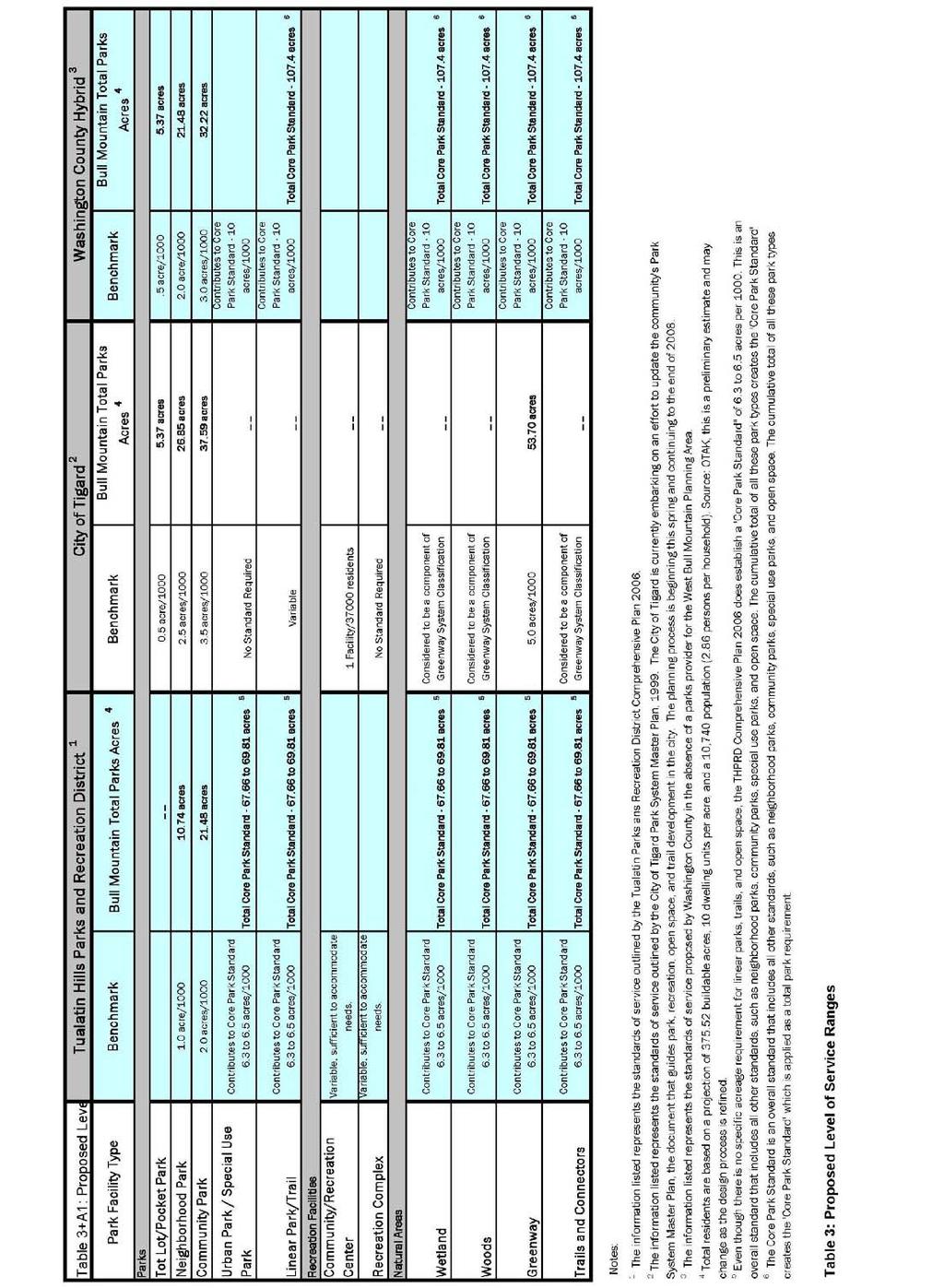
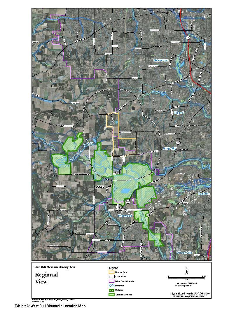
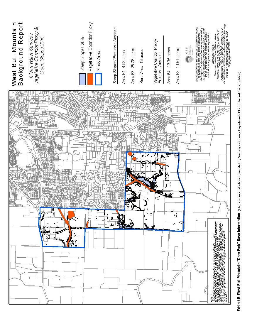
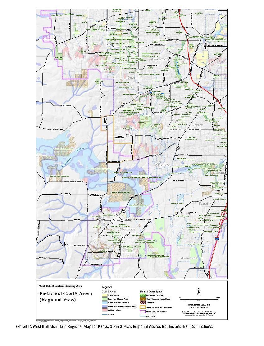
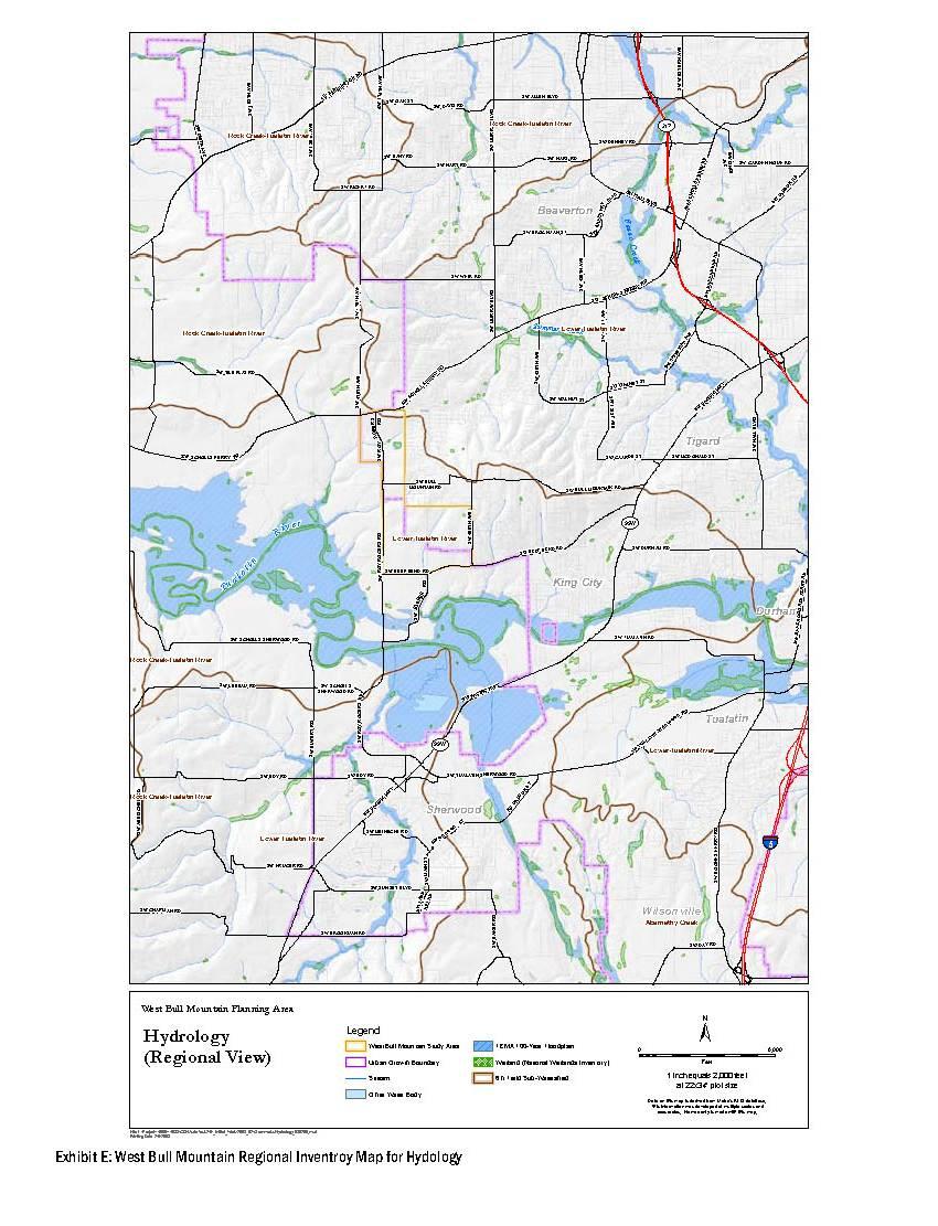
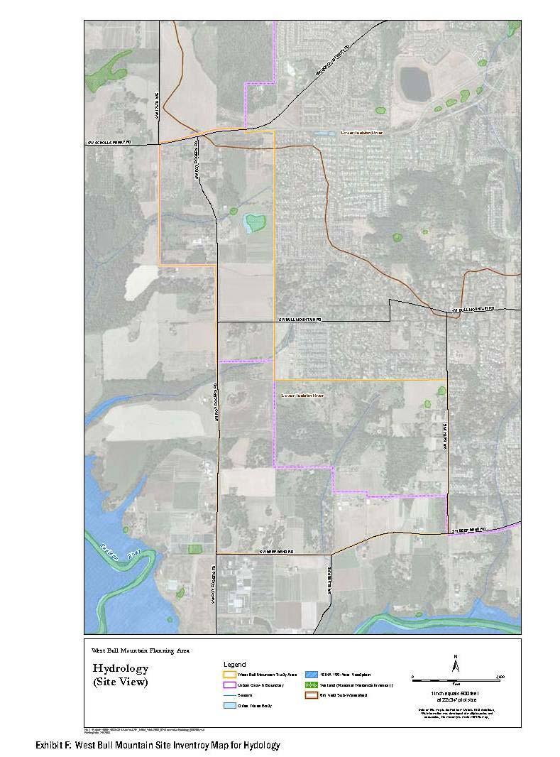
4 Tables Table 1: Park Providers Level of Service Standards Table 2: West Bull Mountain Core Park Totals Table 3: Proposed Level of Service Ranges Exhibits Exhibit A: West Bull Mountain Location Map Exhibit B: Bull Mountain Core Park Base Information Exhibit C: West Bull Mountain Regional Map for Parks, Open Space, Regional Access Routes and Trail Connections Exhibit D: West Bull Mountain Site Inventory Map for Parks, Open Space, Regional Access Routes and Trail Connections Exhibit E: West Bull Mountain Regional Inventory Map for Hydrology Exhibit F: West Bull Mountain Site Inventory Map for Hydrology
5 Section 1 - Introduction About this Report Washington County is developing a community plan for the urban growth boundary expansion Area 63 and Area 64. The West Bull Mountain Planning Area also includes the 212 acres of rural properties (Rural Study Area) situated between Areas 63 and 64 and bound by Roy Rogers and Beef Bend Roads. Areas 63 and 64 were brought into the UGB by Metro in order to accommodate an identified region-wide need for additional land. The plan will include a comprehensive review of the existing inventory of land use, natural resources, transportation, and public facilities, a market study, and survey of the needs of current residents and property owners. A generalized community plan will consider the Rural Study Area in order to evaluate site context and connectivity issues in a comprehensive manner even though it is not within the UGB. The creation of a concept plan for this rural area does not guarantee the area will be ultimately added to the UGB. The project will also identify future land uses, public facilities, including parks and open space, civic uses, and transportation corridors. The West Bull Mountain Community Plan will establish the vision and framework for how new development should occur in order to foster a Community of Great Neighborhoods. Once an initial concept plan is complete, the county will develop a community plan and regulations to implement the concept plan for Areas 63 and 64. A finance plan will also be prepared to determine the costs and financing strategies for the key infrastructure for the planning area. Finally, the new community plan will be implemented through amendments to the county s Comprehensive Plan, including the Community Development Code, and public facility plans. The concept plan calls for an assessment of options regarding the provision of parks and open space, including a consideration of an appropriate level of service for the new urban area. Currently, Area 63 and Area 64 do not have a designated parks provider. A parks provider typically defines the applicable level of service standards based on a comprehensive master plan process. Parks providers in the immediate vicinity of the planning area include the City of Tigard and Tualatin Hills Parks & Recreation District (THPRD). THPRD has expressed an interest as a possible long term parks provider for the area. Washington County will use a separate public process to identify a long term parks provider. During the concept plan process for Area 63, Area 64 and the Rural Study Area, a range of level of service standards for various types of parks, trails, public spaces, open space, and recreational facilities will be identified. This project presents a unique opportunity to have a comprehensive, coordinated approach to land use planning at a relatively broad scale. The county vision for the new area anticipates an urban community with an integrated system of parks and open space. Inventorying existing, adjacent, and planned parks, open spaces, trails, school grounds, and non-developed open spaces in the surrounding area will assist in the analysis of park and public space needs and opportunities. GreenWorks, P.C. 1

6 Section 1 - Introduction Washington County wishes to explore a range of park LOS standards in order to recommend the most appropriate LOS standards for West Bull Mountain. This report provides a comparison of two existing parks service standards - THPRD and the City of Tigard - and a recommended hybrid park LOS that could be provided. This is to be considered as a starting point for the study area, with consideration given to how this applies to the established project community vision and project goals and principles. Determination of the level of service for the parks system is one component of the overall planning effort for West Bull Mountain and recommendations should be referenced to all other system master plans created during the study. Objective Washington County faces a unique challenge in planning, design, and financing a new expansion area at the edge of an existing vibrant, residential community. Parks, open space, and trails are important amenities and should be considered integral components of the planning area s overall community design. However, Washington County is not a parks provider and does not have standards to apply when planning new neighborhoods. In addition, the West Bull Mountain area is not within the service area for the adjacent park providers. The following Initial Examination of Standards for Parks, Trails, Public Spaces and Open Space Memorandum inventories existing conditions, provides a comparison of three LOS standards (THPRD s and City of Tigard s existing park standards and a recommended hybrid), and suggests how these standards may be applied to the study area. The purpose is to begin a discussion of what is appropriate for the new community, and inform future strategies for implementing the standards in West Bull Mountain. GreenWorks, P.C. 2
7 Section 1 - Introduction Location The West Bull Mountain Planning Area is generally bound by SW Beef Bend Road to the south, SW Scholls Ferry Road to the north and SW Roy Rogers Road to the west. The eastern boundary includes SW 150 th Avenue for Area 63 and approximately SW 164 th Avenue for Area 64. The study area encompasses roughly 700 acres of rolling hills, upland forest habitat, stream tributaries to the Tualatin River, orchard and berry farms, and multiple rural residential properties. Exhibit A provides a location map of the West Bull Mountain Planning Area and its boundaries. Level of Service Considerations Parks, open space and trails standards are intended to facilitate the creation of public amenities for the enjoyment of passive and active recreational activities by the residents of a particular area. A range of parks providers were reviewed in the inventory process to document and study regional standards for parks. Table 1 displays the various parks providers and their park level of service standards. The level at which each type of amenity is offered is set by the Level of Service (LOS), which is the tool by which the appropriate type and number of facilities is measured to meet the needs of the community. LOS is calculated by dividing the area, number or length of an amenity by a number of residents in the same area. The Tualatin Hills Parks & Recreation District provides its level of service recommendations in the Tualatin Hills Parks & Recreation District Parks Comprehensive Plan, The City of Tigard outlines its level of service recommendations in City of Tigard Park System Master Plan, These two documents serve as the research and analysis to inform framing ideas about needed parks, trails, open space, recreational amenities, and public spaces for future residents in the West Bull Mountain Planning Area. The recommended hybrid LOS modifies the two city service examples to discern the appropriate standards for this proposed Community of Great Neighborhoods. In all of the examples in this Initial Examination of Standards for Parks, Trails, Public Spaces and Open Space Memorandum, LOS will be represented in acres per 1000 residents. The population base assumed for this report for the West Bull Mountain area including Area 63, Area 64 and the Rural study area, is 10,740 new residents based on a proposed buildable acres. a The number assumed for the population base is used for estimating purposes only and is subject to refinement through the community planning process. a Total residents are based on a projection buildable acres, 10 dwellings units per acre and a 10,740 population base (2.86 people/household). Source: Otak. GreenWorks, P.C. 3

8 Section 2 Recommendations Park, Open Space, and Recreation Standards and Definitions Tualatin Hills Parks & Recreation District In order to prepare and implement a park and open space plan, Tualatin Hills Parks & Recreation District has developed reasonable minimum standards governing the purpose, nature and level of services and amenities. The standards are intended as suggested minimum requirements for the type, design, size and location of park and open space plan features consistent with the needs of the growing population within THPRD s service boundary. The following list represents THPRD s parks definitions and classifications as outlined in its Tualatin Hills Parks & Recreation District Parks Comprehensive Plan, The district s Comprehensive Plan identifies an overall existing level of service standard (i.e., Core Park Standard) of 6.4 acres per 1000 people. The park definitions, classification and level of service standards are being studied and considered by Washington County based on the proximity of THPRD s service boundary to the West Bull Mountain Planning Area. Neighborhood Parks Description: Parks that meet the recreation needs of a surrounding residential neighborhood, including informal play areas, green open space, and opportunities for informal recreation. Includes mini-parks. Size: 2 to 5 acres Acres per People: 1.0 acre/1000 Location: Within 1/2 mile of residents being served. Facilities/Activities: Children's play areas, picnic areas, trails, open grass areas for passive use, outdoor basketball courts, pet areas, and multi-use sport fields, may include natural features but they do not dominate the site. Examples include Forest Hills Park and Hideaway Park. GreenWorks, P.C. 4
9 Section 2 Recommendations Community Parks Description: Larger parks that provide active and passive recreational opportunities for all Park District residents. Accommodates large group activities, including facilities for organized recreation activities and programs. Size: 10 to 25 acres Acres per People: 2.0 acres/1000 Location: Within 3 miles of residents being served. Facilities/Activities: Sport fields, group picnic areas, covered play areas, walking paths, community gardens, skate or BMX facilities, pet areas, and support facilities such as on-site parking and permanent restrooms, may include natural features but they do not dominate the site. Examples include Cedar Hills and Commonwealth Lake Parks. Urban Parks / Special Use Parks Description: Includes urban plazas and large special use areas or facilities designated to a specific purpose and that do not fit into other categories and/or serve multiple needs. Urban plazas also include and support community interaction, highlight cultural or historic resources, enhance the pedestrian experience, and take advantage of occasional small urban spaces not otherwise suitable for park development. Size: Variable: Sufficient size to accommodate activities Acres per People: No standard required. Location: Serves only those pedestrians who are otherwise nearby. Facilities/Activities: Special event (rental) facilities, interpretive areas, day-use camps, and associated open space, educational facilities, natural areas and recreational features. Urban plazas may include interpretive signage, drinking fountains, historical features, benches, trash receptacles, landscaping, paved walkways and plazas, decorative/splash fountain. This category includes the Jenkins Estate, Tualatin Hills Nature Park and Fanno Farmhouse. Linear Parks / Trails Description: Developed lands that follow corridors such as abandoned railroad right-of-way, power line corridors, and other elongated features. Preserve open space and provide public access to trail-oriented activities, which may include walking, running, biking, skating, etc. Some facilities may also provide neighborhood recreation facilities, such as play areas, where adequate space is available. Acres per People: N/A Size: Contributes to the Core Park Standard 6.3 to 6.5 acres/1000 Location: 1/2 mile radius of residents being served. Facilities/Activities: Paved bikeways and walkways, directional and control signage, multi-purpose paved trails, soft-surface trails, boardwalks, gates, benches, overlooks, interpretive facilities, historical features, connections to the city sidewalk and street system. May include natural features but they do not GreenWorks, P.C. 5
10 Section 2 Recommendations dominate the site. The size and location of future linear parks will depend in large part on the location and availability of land surrounding proposed trail connections. All residents or workers within the Park District s service boundary should be able to access the trail system within one-half mile of where they live or work. Examples include Morgan's Run Park and Murrayhill Powerline Park. General Open Spaces Greenways Description: Relatively undeveloped lands that follow stream corridors that may also provide trails with opportunities for walking, running, wildlife viewing, and open space. Size: N/A Acres per People: Contributes to Core Park Standard 6.3 to 6.5 acres/1000 Facilities/Activities: Trails, signage, interpretive features, and natural areas. Examples include Stonemist Park and Willow Creek Park. Core Park Standard Definition The Core Park Standard is an overall standard of park service designed to include all park standards, such as neighborhood parks, community parks, special use parks, and open space/natural areas. Typically the cumulative total of these park types creates the Core Park Standard which is applied as a total park standard for determining level of service requirements. In the West Bull Mountain Planning Area, the Vegetative Corridors combined with the areas with slopes in excess of twenty percent represents a total of approximately acres. Vegetated Corridors are areas adjacent to Sensitive Area (as defined by Clean Water Services) that are preserved and maintained to protect the water quality functions of the Sensitive Area (Sensitive Areas are water areas, including existing and created wetlands, rivers, streams, springs and natural lakes, ponds and in-stream impoundments). Furthermore, a Vegetated Corridor Proxy is an estimated location of the Vegetated Corridor based on the adjacent slope. The actual location of the vegetated corridor is determined when a development application is submitted, and depending on slope may be between 50 and 250 feet. This total acreage amount contributes to the core park standard as open space park land. Exhibit B illustrates areas within the Vegetative Corridor Proxy and slopes in excess of twenty percent. Table 2 determines the acreage amounts contributing to the core park standard for the West Bull Mountain Community Planning Area. City of Tigard In order to prepare and implement a park and open space plan, the City of Tigard has developed reasonable minimum standards governing the purpose, nature and level of services and amenities. The standards are intended as suggested minimum requirements for the type, design, size and location of park and open space plan features consistent with the needs of a growing population. The following list represents the City of Tigard s Tigard Park System Definitions outlined in the City of Tigard Park System Master Plan, The park definitions, classification and level of service standards are being studied GreenWorks, P.C. 6
11 Section 2 Recommendations and considered by Washington County based on the proximity of the parks district boundaries to the West Bull Mountain Planning Area. The City of Tigard is currently embarking on an effort to update the City of Tigard Park System Master Plan, 1999, the document that guides park, recreation, open space, and trail development in the city. The planning process, beginning in Spring 2008, is expected to be completed at the end of The City of Tigard s Comprehensive Plan currently identifies the City s Core Park Standard as 11 acres per 1000 people. Tot Lots/Pocket Parks Description: Pocket Parks provide recreation opportunities for residents in areas not adequately served by neighborhood parks, such as town centers or areas of high density development. Size: 2,500 sq ft, up to 3 acres Acres per People: Minimum of 0.5 acre to serve needs of 1000 people. Location: No Standard Facilities/Activities: Pocket Parks may include passive or low intensity activities, such as children's play areas, pathways, multi-purpose paved areas, public art, small scale sports facilities, seating, picnic areas, community gardens, multipurpose performance space, and landscaping. They generally do not include high intensity sports facilities, restrooms, or off-street parking. Examples include Ash Street Dog Park and the Jim Griffith Memorial Skate Park. Neighborhood Parks Description: Neighborhood Parks are the foundation of the parks and recreation system, providing accessible recreation and social opportunities to nearby residents. When developed to meet neighborhood recreation needs, school sites may serve as neighborhood parks. Size: 4 to 14 acres Acres per People: 2.5 acres to serve needs of 1000 people. Location: 1/2 mile radius of residences without crossing a major street for easy pedestrian and bicycle access Facilities/Activities: Neighborhood Parks should include both passive and active recreation opportunities, such as children's play areas, informal sports areas, picnic facilities, public art, open turf areas, landscaping, community gardens, and pathways. Security lighting may be provided if needed. They generally do not include facilities for large groups, such as sports tournaments, off street parking, or permanent restrooms. Facilities for activities that result in over use, noise, parking problems, and congestions should not be provided. Examples include Elizabeth Price Park. Community Parks Description: Community Parks provide a variety of active and passive recreational opportunities for all age groups. These parks are generally larger in size and serve a wider base of GreenWorks, P.C. 7
12 Section 2 Recommendations residents than neighborhood parks. Community Parks often include developed facilities for organized group activity as well as facilities for individual and family activities. Size: Greater than 15 acres Acres per People: 3.5 acres to serve needs of 1000 people. Location: No Standard Facilities/Activities: In addition to those amenities provided at neighborhood parks, community parks may include sports facilities for team play, group picnic areas, skateboard and rollerblade facilities, natural areas, botanical gardens, amphitheaters, festival space, swimming pools, interpretive facilities and community centers. Higher quality children's play areas may be provided to create a family play destination. Examples include Summerlake Park and Cook Park. Linear Parks/ Trails Description: Linear Parks may be developed along built or natural corridors to provide for trail-oriented activities and natureoriented outdoor recreation. Linear parks may also provide some active and passive recreation facilities to meet neighborhood needs, especially in areas not adequately served by traditional neighborhood parks. Linear parks connect residences to major community destinations. Size: Of adequate size to protect natural resources and accommodate intended uses Acres per People: Variable Location: No Standard Facilities/Activities: Linear parks can include paved or softsurfaced trails to accommodate jogging, biking, walking, skateboarding, dog walking, horseback riding, canoeing, or rollerblading. Active and passive recreation facilities may include small scale sports facilities, such as basketball hoops, children's play equipment, off-leash dog areas, seating, public art, picnic tables, lighting, community gardens, and landscaping. Recreation facilities intended for large groups, permanent restrooms, and off-street parking are generally not provided. Examples include Liberty Park and Main Street Park. General Open Space Greenways Description: A greenspace or greenway is an area of natural quality that protects valuable natural resources and provides wildlife habitat. It also provides opportunities of nature-related outdoor recreation, such as viewing and studying nature and participating in trail activities. Size: Size should be adequate enough to protect the resource Acres per People: 5.0 acres/1000 Facilities/Activities: Developed features that support outdoor recreation and trail-oriented recreation may be provided, such as trails, picnic areas, benches, interpretive signs, and native GreenWorks, P.C. 8
13 Section 2 Recommendations landscaping. Trail-head amenities, such as small scale parking, portable restrooms, bike racks, and trash enclosures may be included. Facilities that do not directly support outdoor recreation and trail-oriented recreation should not be included, such as ornamental plants, lawns and active recreation facilities. Examples include Jack Park and Woodward Park Nature Trails and Scenic Pathways Description: A public access route for commuting and trailoriented recreational activities, include sidewalks, bikeways, multi-use trails and paths Size: No Standard Location: Width of the trail and right-of-way depends on its intended use and location. Facilities/Activities: A variety of pathway types are needed to accommodate activities such as walking, running, biking, dog walking, rollerblading, skateboarding, and horseback riding. Trails can be located within parks, within linear parks and greenways, or be designed as a part of the citywide transportation system. Waterways can provide trail-like facilities for boating and canoeing. Each type of trail should be designed to safely accommodate users, and meet recognized design standards. Active recreation facilities and facilities that do not directly support outdoor recreation and trail-oriented recreation should not be included, such as ornamental plants, lawns, and active recreation facilities. Examples include Fanno Creek Park and Englewood Park. GreenWorks, P.C. 9

14 Section 2 Recommendations Proposed West Bull Mountain Concept Plan Level of Service Table 3 projects a hybrid level of service for West Bull Mountain, using the above LOS ranges for THPRD and Tigard and considers the projected population of 10,740 for the West Bull Mountain Planning Area. The narrowing of possible parks standards from Table 1 to Table 3 is consistent with the scope of work which calls for the identification of 2 to 3 ranges of LOS. The park providers were selected because of their close proximity to the West Bull Mountain Planning Area and the varying ranges of LOS. Interpretation and application of proposed level of service ranges will require continued coordination with Washington County and stakeholders. Table 3 also includes a recommended hybrid level of service for consideration in the West Bull Mountain community planning area. The initial hybrid standards are levels between the levels provided by Tigard and THPRD. These hybrid standards are dependent upon multiple variables and will be refined through the design process. GreenWorks, P.C. 10
15 Section 3 - Inventory Regional Access Routes, Parks, Open Space, Schools, and Trails Inventory While the standards will set guidelines by which parks, open space, and trails are created, the site, and context will determine how and where they can be implemented. Regional and site conditions will directly affect the potential of parks, open space, and trails in the West Bull Mountain Planning Area. West Bull Mountain is located at the southwest gateway into the Portland Metro area, within a short drive of over 2 million residents. Nearby major population centers include: Portland, Beaverton, Tigard, and Sherwood. Exhibit C displays the Regional Inventory Map for Parks, Open Space, Regional Access Routes, and Trail Connections. Regional Vehicular Access Routes SW Roy Rogers Road is the major north-south vehicular connection to and through the planning area and poses challenges in creating effective neighborhood connections, especially in Area 64. However, like natural features, it forms a strong edge to parts of the West Bull Mountain Planning Area. SW Scholls Ferry Road, Bull Mountain and Beef Bend Roads are the primary eastwest vehicular connections for access. Regional Open Space Tualatin River National Wildlife Refuge Located in proximity to the southwest corner of the West Bull Mountain Planning Area, the Tualatin River National Wildlife Refuge is situated within the floodplain of the Tualatin River and is home to nearly 200 species of birds, over 50 species of mammals, 25 species of reptiles and amphibians, and a wide variety of insects, fish and plants. The Tualatin River National Wildlife Refuge is one of over 540 refuges in the National Wildlife Refuge System, a network of lands and waters set aside specifically for wildlife. Managed by the U.S. Fish and Wildlife Service, the Refuge is a living heritage, conserving fish, wildlife and their habitats for future generations where one can experience and learn about wetland and river ecology. Habitats include remnant and restored communities along rivers and streams, emergent, shrub, and forested wetlands, riparian forests, oak and pine meadows and grasslands, and mixed deciduous/coniferous forests common to western Oregon prior to settlement. Two high priorities of the U.S. Fish and Wildlife Service are the restoration of native habitats associated with the Tualatin River floodplain and environmental education and interpretation opportunities for the public. GreenWorks, P.C. 11
16 Section 3 - Inventory By experiencing the Refuge through one s natural sense of discovery, one can make important connections with the natural world. The Tualatin River National Wildlife Refuge provides a variety of recreational and educational activities as well as trail facilities focused on wildlife and habitat. Tualatin River Trail A one-mile long nature trail meanders through a variety of refuge habitats, past wildlife viewpoints and interpretive stops and ends in an expansive view at the wetland observation deck. This trail surface is made up of compact gravel. From the parking lot to the wetland observation deck, the grade of the yearround nature trail does not exceed 5%. Tualatin River National Wildlife Refuge Seasonal Trails From May 1st through September 30th, visitors are permitted to walk on 3 miles of service roads. The road surface is uneven, loose gravel. From October 1st through April 30th, the seasonal trails (service roads) are closed to all public entry to provide sanctuary for wildlife. The Refuge is within one mile of the West Bull Mountain Planning Area. Regional Trails The Tualatin River Valley creates a very diverse landscape within the region with the Tualatin River providing the physical southern border to the southwest extents of the UGB. Intertwined with the natural features are several regional trails that have been outlined in Metro s Trails Master Plan. The trail pattern, along with the open space that has been assembled, is directly correlated to the creeks and ridges in the region. Listed below are several of the regional trails, one of which is a water trail which could potentially connect to a local trail system in the West Bull Mountain Planning Area. Tualatin River Water Trail This water trail has become very popular during the past several years thanks, in part, to the efforts of the Tualatin Riverkeepers. Several excellent launch sites are operated by local jurisdictions: Rood Bridge Park in Hillsboro, Cook Park in Tigard and Brown's Ferry Park in Tualatin. Open space properties acquired by Metro along the Tualatin River will serve as additional future access points. This water trail runs from the Tualatin's confluence with the Willamette River west toward Hagg Lake. The Tualatin River Water Trail is within one mile of the West Bull Mountain Planning Area. GreenWorks, P.C. 12

17 Section 3 - Inventory Tonquin Trail (Proposed) This trail will run south from the Tualatin River National Wildlife Refuge through Sherwood and Wilsonville to the Willamette River Greenway. Within three miles of the West Bull Mountain Planning Area, the Tonquin Trail is a current target area for Metro s 2006 Natural Areas Bond Measure. The trail is currently being reviewed in Metro s refinement process to target acquisition areas for the trail alignment. Lower Tualatin River Greenway Trail (Proposed) This trail will run along the Tualatin River from its confluence with the Willamette River west to the Tualatin River National Wildlife Refuge. The trail will be within two miles of the West Bull Mountain Planning Area. Westside Trail This 24-mile north/south alignment stretches from the Tualatin River in Tigard north through Beaverton, unincorporated Washington and Multnomah counties through Forest Park to the Willamette River. The corridor, located within one mile of over 120,000 residents, and near numerous parks, schools, regional centers and the MAX line, could become a primary Westside recreation and nonmotorized commuter spine. The Westside Trail will be located primarily within a scenic 16-mile utility corridor stretching from the Tualatin River in King City through Tigard, Beaverton and the Cedar Mill & Bethany areas in north unincorporated Washington County. Mostly owned by the Bonneville Power Administration (BPA), the corridor averages 225 feet in width, approximately 25 feet of which will be needed for the trail. The Westside Trail is within five miles of the West Bull Mountain Planning Area. Currently some portions of the Westside Trail have been constructed. Bull Mountain Parks Inventory Parks located in the vicinity of Bull Mountain will be potentially linked to the future park system. These parks will enhance existing connectivity and assist in providing additional connectivity but do not satisfy the requirements for the standards for the level of service for the West Bull Mountain Concept Plan area. The following areas listed may be classified as park, open space, linear park, and/or natural areas in general proximity of the West Bull Mountain Planning Area. Barrows Park/ Barrows Trail/ Progress Lake Park Size: Approx. 8 acres Parks Provider: THPRD Location: SW Beaverton Type: Urban Park/Special Use Park and Trail Corridor Amenities: Plaza, Trail, future fishing pier GreenWorks, P.C. 13

.")


18 Section 3 - Inventory Cache Creek Nature Park Size: 19 acres Parks Provider: City of Tigard Location: Tigard; SW 150 th Avenue. Type: Nature Park, Community Park Amenities: Nature area, trails, picnic areas (Trails will also connect to the Westside Trail described previously). Cook Park Size: 79 acres Parks Provider: City of Tigard Location: Tigard; south of Durham Road at the end of SW 92nd Avenue. Type: Community Park Amenities: Sports fields & courts, picnic areas, river access David s Windsor Park Size: 3.2 Acres Parks Provider: THPRD Location: Beaverton; Access off Harlequin Road, East of Sheldrake Road. Type: Natural Area Edgewater Park Size: 17 Acres Provider: City of King City Location: King City; West of 131 st Avenue Type: Neighborhood Park Amenities: Activity field, off-leash dog park, tennis courts, playground, picnic tables, river access,. GreenWorks, P.C. 14


19 Section 3 - Inventory Elizabeth Price Park Size: 2.5 Acres Provider: City of Tigard Location: Tigard; SW Bull Moutain Road, opposite Alberta Rider Elementary School Type: Neighborhood Park Amenities: Playground, picnic tables, interpretive trail and reservoir. Under construction and expected to open in the summer of 2009 Murrayhill Park Size:.41 Acres Parks Provider: THPRD Location: Beaverton; Along the Westside Trail Type: Neighborhood Park Amenities: On Bus Route, Playground, Tennis, Trails Murrayhill Powerline Park Size: Acres Parks Provider: THPRD Location: Beaverton; Westside Trail corridor between Scholls Ferry and Weir Road Type: Linear Park Amentities: On Bus Route Trails Scholls Wetlands Size: 3.7 Acres Parks Provider: THPRD Location: Beaverton; NE corner of Barrows Rd. and Walnut Rd. Type: General Open Space / Wetlands Amentities: On Bus Route GreenWorks, P.C. 15
20 Section 3 - Inventory Local Schools The West Bull Mountain Planning Area is located in both the Beaverton School District and the Tigard-Tualatin School District, with the majority of the planning area located in the Tigard- Tualatin School District. At this time, the Beaverton School District does not have plans to construct school facilities in the portion of Area 64 located in its district boundary. The Tigard- Tualatin School District currently owns a 20 acre parcel in Area 63 and continues to explore opportunities for acquisition of additional land for future school sites in the planning area. The Tigard-Tualatin School District focuses on the classroom and student achievement and is committed to providing excellent classroom instruction and a variety of learning alternatives. Ideally, the West Bull Mountain Planning Area will maximize shared use of recreational facilities to avoid cost duplication. Partnership opportunities with the Tigard-Tualatin School District can be explored in the design process so that adjoining parks may be aligned and associated with new school site(s). The following list of schools outlines public school ground locations within the regional zone outlined in the Regional Inventory Map. o Alberta Rider Elementary School Location: SW 132nd Terrace, Tigard, OR o Charles F. Tigard Elementary School Location: SW Grant Avenue, Tigard, OR o Deer Creek Elementary School Location: SW 131st Avenue, Tigard, OR o Fowler Middle School Location: SW Walnut Street, Tigard, OR o Hazelbrook Middle School Location: SW Hazelbrook Road, Tualatin, OR o James Temleton Elementary School Location: 9500 SW Murdock Street, Tigard, OR o Mary Woodward Elementary School Location: SW Katherine Street, Tigard, OR o Nancy Ryles Elementary School Location: SW Cormorant Drive, Beaverton, OR Type: Public School o Scholls Heights Elementary Location: SW Loon Drive, Beaverton, OR o Tigard High School Location: 9000 SW Durham Road, Tigard, OR o Twality Middle School Location: SW 97th Avenue, Tigard, OR GreenWorks, P.C. 16

21 Section 3 - Inventory Parks, Open Space, School Grounds, and Trails Inventory The West Bull Mountain Planning Area is bordered by existing residential neighborhoods to the northeast and east and by undeveloped farmland, forests, wetlands, and the Tualatin River to the south and west. The neighborhoods directly adjacent to the project boundary can use the park and recreation resources developed in the West Bull Mountain Planning Area and vice versa. Identifying existing assets and future needs in the planning area will help to define the program for parks, open space, and trails. Exhibit D displays the Site Inventory Map for the West Bull Mountain Parks, Open Space, Access Routes, and Trail Connections for the area immediately adjacent to the planning area. GreenWorks, P.C. 17
22 Section 4 - Strategies Strategies The following strategies are preliminary ideas for creatively implementing the park level of service standards in the context of West Bull Mountain Planning Area. Strategies for Creating Connectivity Connectivity will be the most important factor in creating a seamless and integrated park and open space system. The following strategies acknowledge that the open space corridors will be the most important component of linking different neighborhoods and amenities together. Preserving Open Space Purchasing open space along Vegetated Corridors would be an effective method of creating trail corridors without interfering with natural systems (see Diagram A). Creating Greenways with Open Space In the absence of natural corridors, greenways can serve as edges between different land uses as well as varying densities. As open space they will be purchased and reserved as wildlife corridors and trails. In order to meet multiple objectives, locations for greenways may be areas identified as upland habitat on Metro s Habitat Inventory Map and in Pacific Habitat Services Natural Resources Assessment (April 23, 2008) (See Diagram A). Creating Greenways with Easements Purchasing easements is an alternative to the purchase of open space. The greenway s size and purpose will help to determine which method is most appropriate (See Diagram A). Using Parks as Access Points Parks can serve as gateways and trailheads to the larger trail network. They can also extend the perceived amount of open space by placing them next to open space corridors and other natural resource areas. Using the Street Grid Tree lined streets with sidewalks will be an important component of the pedestrian circulation system for West Bull Mountain. To connect this system to the larger trail network certain streets could have an urban trail character, where changes in paving materials, sidewalk width, and plantings signify the importance of the sidewalk. These linear pedestrian corridors could have adjacent stormwater swales and have direct links to parks or trail heads, seamlessly weaving urban and natural pedestrian corridors. Incorporating stormwater and pedestrian connections into the street right of way could be relative to the hierarchy of the street, from neighborhood street collector to stormwater boulevard. (See Diagram A, B, C & D). Using Parks as a Community Edge Creating linear parks and trail systems that are parallel and adjacent to arterial roads could maximize the role of this interconnected network of natural areas throughout the community. Busy high traffic roadways present GreenWorks, P.C. 18

23 Section 4 - Strategies challenges for connectivity. Marrying stormwater infrastructure with active and passive recreation would provide a green buffer to high volume transportation corridors and assist in developing neighborhood identity. Diagram D illustrates opportunities for aligning linear stormwater facilities and linear parks adjacent to a high volume transportation corridor (See Diagram D).The local hydrology, topography and geology, as reported in the phase one geotechnical analysis and draft stormwater report for West Bull Mountain, pose challenges to incorporating low impact development applications (LIDA) within the planning area, such as stormwater swales and stormwater boulevards. Understanding these constraints will be essential when considering which, if any, LIDA can be used to achieve the above two strategies (Using the street grid and Using parks as a community edge). Diagram A: Connectivity Strategies GreenWorks, P.C. 19


24 Section 4 - Strategies Diagram B: Connectivity Strategy - Using the Street Grid Neighborhood Street Diagram C: Connectivity Strategy - Using the Street Grid Stormwater Boulevard GreenWorks, P.C. 20

25 Section 4 - Strategies Diagram D: Connectivity Strategy - Using Parks as a Community Edge Linear Stormwater Park Section Strategies for Creating Parks and Open Space There are several scales to creating character and identity. At the largest scale, the West Bull Mountain Planning Area will need an image that will distinguish its park, open space, and trail system. On the smallest scale, neighborhoods will be identified by the parks and open space in their immediate vicinity. Regardless of scale, the perception of a park, open space, or trail as special and unique builds pride and ownership in the users of the amenities. Listed below are a few ideas for creating such an image and strategies for creating parks and open space. Building on the History of Agrarian Landscape - The plan objective for the new area is for urbanization, however; the agricultural history of the West Bull Mountain Planning area is an important part of this site and the larger region. Part of that story and culture could be expressed through the character of one or several parks, a community garden, or an orchard showcasing the diversity and history of the agrarian landscape. There are several existing farm accessory buildings and barns which could be preserved as historic markers and could be incorporated into open spaces or parks as a part of the public domain. One opportunity may be to focus this effort at the edges, as a way to buffer the urbanizing area from the existing adjacent agricultural landscape. Another opportunity may be to consider using the area to create a Community Supported Agriculture (CSA) or non profit organization for local food production such as a community orchard or community berry farm associated with park space. Associating Parks with Stream Corridors - The existing watershed could become one the method for naming and placing neighborhood parks. Parks could serve as entranceways to the larger trail network along the existing creek corridors. GreenWorks, P.C. 21


26 Section 4 - Strategies Associating Parks with Historic and Cultural Resources - The existing history of the site and the area provides another opportunity for naming and placing neighborhood parks in order to relate the historical story of the area. Associating Parks with Neighborhood Centers - Creating a village and neighborhood center with open spaces and urban plazas within a five minute walk or one quarter mile radius from center to edge for all residents. Park centers allow opportunities for incorporating on site stormwater best management practices. An urban plaza within a village green or neighborhood center would help create identity within a neighborhood and foster community. Diagram E illustrates the relationship of the proximity of the Village and Neighborhood Center to its resident users. Diagram F illustrates a section view of the Village and Neighborhood Center as an urban plaza with on-site stormwater facilities. Associating Parks with Areas of Excessive Slopes Areas with excessive slopes present development challenges and possible erosion and landslide hazards. Areas with slopes in excess of twenty percent can be preserved as open space and/or provide possible recreation challenge courses. Diagram E: Associating Parks with Village and Neighborhood Centers Diagram F: Associating Parks with Village and Neighborhood Centers Section GreenWorks, P.C. 22

27 Section 4 - Strategies Associating Parks with Schools Creating parks in association with the school proposed by the Tigard-Tualatin School District within the boundaries of the West Bull Mountain Planning Area would provide an extension of the civic domain. Parks placed adjacent to schools would complement school facilities and foster community centers. Associating Parks with Vegetated Stream Corridors, Wetlands and other Natural Resource Areas Creating linear parks and trail systems that are parallel and adjacent to linear stormwater facilities (if feasible) and vegetated stream corridors, wetlands, and other natural resource areas could maximize the role of this interconnected network of natural areas throughout the community. Diagram G illustrates a section view of the relationship of the Vegetated Corridor, the linear stormwater facility, and the Linear Park. Diagram G: Associating Parks with Vegetated Stream Corridors - Section Associating Parks with Urban Services Infrastructure Creating parks that share sites with other infrastructure could maximize land use and provide community civic space. In the event that the community s future water supply infrastructure included a reservoir, a park could be developed in concert with the reservoir, like Elizabeth Price Park which will be constructed on top of the new reservoir currently being built on SW Bull Mountain Road. Historic examples of shared public water facilities and park space GreenWorks, P.C. 23
28 Section 4 - Strategies include Washington Park and Mount Tabor Park in Portland dating from as well as Central Park in New York City. Strategies for Sharing Facilities Recreational facilities exist on and off the site that can work with the parks and open space network developed for West Bull Mountain so that facilities are not duplicated unnecessarily. This will reduce the overall demand on maintenance costs between the parks provider and the partnering urban service provider or governmental agency, such as the Tigard-Tualatin School District. Existing schools, along with any other schools or public services proposed on site should be coordinated with the parks provider regarding parks, open space, and trail system to offer pedestrian links to amenities, educational opportunities for students, and recreational opportunities. Ball fields, gymnasiums, and courts could help meet the recreational needs of the community if the amenities are made available for public access after school hours. For instance, the Hillsboro School District partnered with the City of Hillsboro to build a larger gymnasium facility in the new Lincoln Street Elementary currently under construction than would otherwise have been funded through last year s bond measure. Strategies for Creating a Sustainable Community Listed below are several strategies for integrating parks, open space and trails with natural systems including habitat protection and stormwater management. A Stormwater Management Plan will accompany the concept planning process and identify potential areas where parks and stormwater management can be integrated. Tree Canopy Goals Preserving existing tree canopies and planting new tress, thus establishing new tree canopies, helps to provide habitat, reduce stormwater, decrease heat island effect, and sequester carbon dioxide. Increasing the percentage of tree canopies attributes to a higher rate of evapotranspiration, an essential process of the water cycle. Evapotranspiration accounts for 10 percent of the moisture in the atmosphere. American Forests ( has created goals for the Willamette/Lower Columbia region of 40% canopy overall, 50% canopy in suburban residential zones, 25% canopy in urban residential zones, and 15% canopy in central business districts. Stormwater Detention in Parks The Healthy Streams Plan 2005 issued by Clean Water Services outlines goals to enhance the effectiveness of and increase options for managing on site stormwater. Locating stormwater detention systems within parks can reduce the land needed for both facilities and create opportunities for education, visual amenities, and recreational activities. In West Bull Mountain, Clean Water Services is GreenWorks, P.C. 24
29 Section 4 - Strategies interested in implementing on-site stormwater management that is appropriate and safe given the topographical and geological conditions in the planning area. Green Streets Metro s Green Street Guide provides guidelines for reducing the impact of stormwater runoff in neighborhoods. The guidelines include increasing tree canopy along streets. Beyond the benefits to the hydrologic system green streets can promote healthier communities by contributing to the overall tree canopy and enhancing the character of a neighborhood. As stated previously, West Bull Mountain s hydrology, topography and geology may limit the extent that new streets are designed as Green Streets. Habitat Connectivity is an important component of preserving wildlife habitat. Protecting tree stands and stream corridors and then linking them to the larger region will allow a variety of species to move throughout the region unimpeded by development. Sense of Place - A "sense of place" results when design and development protect and incorporate the distinctive character of a community and the particular place in which it is located. The distinctive qualities of the Pacific Northwest including its geography, natural features, climate, culture, historical resources, and ecology each contribute to the distinctive character of the region. Creating a sense of place provides residents with greater ties to their community and increases stewardship of their natural environment. GreenWorks, P.C. 25

30 Tables GreenWorks, P.C. 26
31 GreenWorks, P.C. 27
32 GreenWorks, P.C. 28
33 GreenWorks, P.C. 29

34 Exhibits GreenWorks, P.C. 30
35 GreenWorks, P.C. 31
36 GreenWorks, P.C. 32
37 GreenWorks, P.C. 33
38 GreenWorks, P.C. 34
39 GreenWorks, P.C. 35
40 GreenWorks, P.C. 36
1. Parks & Recreation Neighborhood Parks Community Parks Special Use Sites 2. Open Space 3. Trails
 Appendix A: Park Classifications The intent of parks and recreation classifications is to aid in making acquisition and design decisions for park sites, facilities and the organization of recreation space
CITY OF TIGARD EXPECTED SERVICE AREA
 CITY OF TIGARD EXPECTED SERVICE AREA City overview / Background Incorporated in 1961, the has experienced rapid growth over the years. This growth can be attributed to many factors, primarily the close
Mendota Heights 2040 Comprehensive Plan Draft Vers
 4 Parks and Trails The City of Mendota Heights boasts a variety of recreational and open space opportunities. Few cities can claim access to regional trails, riverside and lakeside parks, scenic bluffs
3. VISION AND GOALS. Vision Statement. Goals, Objectives and Policies
 Vision Statement Queen Creek s interconnected network of parks, trails, open spaces and recreation opportunities provide safe and diverse activities and programs that sustain its unique, small town, equestrian
Westbound: A One-day Exploration of Growth
 Westbound: A One-day Exploration of Growth Frog Pond Area 2018 UGB Expansion Proposal June 13, 2018 Growing Out: UGB Asks Four cities submitted proposals to expand greater Portland s urban footprint by
RECREATION, OPEN SPACE AND GREENWAYS ELEMENT GOALS, OBJECTIVES, AND POLICIES
 RECREATION, OPEN SPACE AND GREENWAYS ELEMENT GOALS, OBJECTIVES, AND POLICIES GOAL R-1: DEVELOP A RECREATION, OPEN SPACE AND GREENWAYS SYSTEM AS AN INTEGRAL COMPONENT OF AN OVERALL, COUNTY-WIDE ECONOMIC
ARTICLE IV: DEVELOPMENT STANDARDS 404 MASTER PLANNING
 IV 13 404 MASTER PLANNING Master Planning through the Site Analysis (Master Planning Site Analysis) or Planned Development (Master Planning Planned Development) is provided to encourage development which
The following principles guide the development of goals and strategies to protect and promote these amenities:
 OPEN SPACE/PARKS/TRAILS/RECREATION GOALS/STRATEGIES Cherry Hills Village is a living environment that offers low density development, open areas, public scenic vistas, public trails and public parks. This
Gold Line Bus Rapid Transit Transit Oriented Development (BRTOD) Helmo Station Area Plan
 Helmo Station Area Plan") Appendix F Gold Line Bus Rapid Transit Transit Oriented Development (BRTOD) Helmo Station Area Plan Introduction and Purpose of the Plan The Gold Line Bus Rapid Transit facility is an eleven-mile dedicated
Appendix F Gold Line Bus Rapid Transit Transit Oriented Development (BRTOD) Helmo Station Area Plan Introduction and Purpose of the Plan The Gold Line Bus Rapid Transit facility is an eleven-mile dedicated
Chapter 6. Overall Vision RECOMMENDATIONS. More Trail and Trail. Connections. Equal Access to Park. Facilities and Programs. Water Access.
 Overall Vision More Trail and Trail Connections Equal Access to Park Facilities and Programs Water Access Environment Variety Chapter 6 RECOMMENDATIONS Chapter 6 The following recommendations for park,
Chapter 5: Recreation
 Chapter 5: Recreation Introduction and Setting Recreational opportunities within Nevada County are varied, ranging from public parks with intensively used active recreational facilities, to vast tracts
Neighborhood Districts
 NEIGHBORHOOD DISTRICTS SEVEN MAIN DISTRICTS Neighborhood Districts While the Development Plan provides a broad-scale overview of the neighborhood, this section focuses on uses and relationships at the
Description of Preferred Alternative
 Chapter 2 Description of Preferred Alternative 2.1 Introduction This chapter of the programmatic Sammamish Town Center Sub-area Plan Final EIS provides a more detailed description of the Preferred Alternative
10.0 Open Space and Public Realm
 10.0 Open Space and Public Realm 10.0 Open Space and Public Realm The Public Open Space System is comprised of: outdoor spaces available for public use that are either publicly owned (e.g., parks and
DRAFT. William. Level of Service for Parks. NORTH BETHANY. Project Team
 DRAFT Level of Service for Parks NORTH BETHANY Project Team William May 18, 2007 Submitted To Washington County Department of Land Use and Transportation 155 North First Avenue, Suite 350 Hillsboro, OR
The urban parks in Charlottesville include Jackson Park, Lee Park, and McGuffey Park.
 Park Classifications Charlottesville s parks can be grouped into 4 different classifications: urban parks, neighborhood parks, community parks, and regional parks. Figure 1 on page 5 inventories the facilities
Throughout. square. (Crystal City Vision Plan 2050)
") 1: Terms related to the PSMP document 1 public space (see also public realm, civic space) An open space designated on the regulating plan, accessible to all, including Plazas, Mini Parks, and Neighborhoods
1: Terms related to the PSMP document 1 public space (see also public realm, civic space) An open space designated on the regulating plan, accessible to all, including Plazas, Mini Parks, and Neighborhoods
Northeast Quadrant Plan
 Northeast Quadrant Plan Northeast Quadrant Distinctive Features Land Use The Northeast Quadrant includes all the area within the planning area that is east of Interstate 5 and to the north of State Route
WASHINGTON COUNTY OREGON
 WASHINGTON COUNTY OREGON July 9, 2009 Revisions to Chapter 2 of the Bethany Community Plan The North Bethany Subarea Plan Exhibit pages 7 and 8 The sections for the Core and Flexible Streets were amended
BROOKHILL NEIGHBORHOOD MODEL ZONING MAP AMENDMENT PREFACE TO APPLICATION
 BROOKHILL NEIGHBORHOOD MODEL ZONING MAP AMENDMENT PREFACE TO APPLICATION June 15, 2015 Revised: August 1, 2016 I. VISION Brookhill is a proposed community based upon the principles of Albemarle County
West Bull Mountain Concept Plan REPORT OCTOBER (http://www.co.washington.or.us/westbullmt)
") West Bull Mountain Concept Plan REPORT (http://www.co.washington.or.us/westbullmt) i OCTOBER 2010 This page intentionally left blank West Bull Mountain Concept Plan i West Bull Mountain Concept Plan Prepared
West Bull Mountain Concept Plan REPORT (http://www.co.washington.or.us/westbullmt) i OCTOBER 2010 This page intentionally left blank West Bull Mountain Concept Plan i West Bull Mountain Concept Plan Prepared
RECREATION AND OPEN SPACE ELEMENT GOALS, OBJECTIVES, AND POLICIES
 RECREATION AND OPEN SPACE ELEMENT GOALS, OBJECTIVES, AND POLICIES Goal 7 To provide park facilities, recreation programs, and open space resources that are safe, adequate, and accessible to all City residents,
APPENDIX D: PARKS AND RECREATION ACTION PLAN
 APPENDIX D: PARKS AND RECREATION ACTION PLAN Goals The following goals are specific to the development, maintenance, and operation of the existing parks in the Township, as well as the acquisition and
NORTH BETHANY ELEMENTARY SCHOOL SITE ASSESSMENT
 NORTH BETHANY ELEMENTARY SCHOOL SITE ASSESSMENT Prepared for: Prepared by: October 10, 2014 Page 2 Introduction and Purpose This report provides an assessment of two potential sites for a new elementary
Ten Mile Creek Planning Area
 PLANNING AREA POLICIES TEN MILE CREEK Ten Mile Creek Planning Area Location and Context The Ten Mile Creek Planning Area ( Ten Mile Creek area ) is located south of the current Boise AOCI, generally south
PARTF Scoring System for Grants
 PARTF Scoring System for Grants The members of the N.C. Parks and Recreation Authority use the PARTF scoring system as one of several tools to select grant recipients. Please provide all of the information
Regional Context Statement
 Regional Context Statement REGIONAL CONTEXT STATEMENT 3. REGIONAL CONTEXT STATEMENT In 1995, the Provincial Government passed into law the Growth Strategies Act. The purpose of this provincial initiative
Midtown Greenway Land Use and Development Plan Executive Summary
 Midtown Greenway Land Use and Development Plan Executive Summary Introduction The Midtown Greenway Land Use and Development Plan sets policy direction for land use and development in the Midtown Greenway
Courthouse Planning Area
 Courthouse Planning Area Current Reality The Courthouse Planning Area is the characterized by expansive suburbanscale residential areas as well as the community resource planned area of athletic, educational,
OPEN SPACE CHAPTER 7: OVERVIEW. Preserve open space to protect natural resources, enhance character and provide passive recreation opportunities
 CHAPTER 7: OPEN SPACE OVERVIEW Ridgefield has made tremendous progress permanently preserving areas of town as open space. Open space preservation can serve many important purposes, including: protect
Southeast Quadrant Plan
 Southeast Quadrant Plan Southeast Quadrant Distinctive Features Land Use The Southeast Quadrant includes all the area within the planning area that is east of Interstate 5 and south of State Route 44.
BISCUIT RUN PARK MASTER PLAN
 BOARD OF SUPERVISORS November 14, 2018 BISCUIT RUN PARK MASTER PLAN COUNTY OF ALBEMARLE ANHOLD ASSOCIATES Contents Project Introduction Property Background County Park Planning Process Existing Site &
Parks, Trails, and Open space Element
 Parks, Trails, and Open space Element Parks, Trails, and Open Space element Parks, Recreation, and Open Space are important components of the quality of life desired by the residents of Elk Grove. This
This page intentionally blank.
 This page intentionally blank. Parks, Recreation, and Open Space Chapter Relationship to Vision Vision Parks, Recreation and Open Space Chapter Concepts County Government. County government that is accountable
RECREATION AND OPEN SPACE ELEMENT
 RECREATION AND OPEN SPACE ELEMENT Last amended August 19, 2008 Table of Contents Objective Page 5.1 Park system defined... 5-1 5.2 Access to parks and recreational facilities... 5-2 5.3 Recreation and
Section 3 INVENTORY OF RECREATION LAND AND FACILITIES
 Photo of Juan Bautista de Anza Park Section 3 INVENTORY OF RECREATION LAND AND FACILITIES Summary of Findings Park Definitions Summary of Recreation Facilities Other Recreation Facilities Nearby Recreation
WASHINGTON COUNTY OREGON
 WASHINGTON COUNTY OREGON LONG RANGE PLANNING DIVISION North Bethany Subarea Stream Corridors: Existing Regulations In Oregon, there is a distinct difference between the land use rules that apply in rural
The Vision. Photo provided by The Minervini Group. 46 Vision, Objectives & Strategies
 Vision, Objectives & Strategies The is the public framework and guide for future development of the Grand Traverse Commons. The establishes public polices for infrastructure, the preservation of natural
City of Nogales General Plan
 Open Space, Parks, Recreation and Trails City of Nogales General Plan Residents of Nogales place a high priority in the development of a comprehensive system of open space, parks, recreation and trails
Transportation. Strategies for Action
 Transportation A major priority for the Overlake Neighborhood is to develop a multimodal transportation system. To achieve this system, a balance has to be found among travel, circulation and access needs;
COMMUNITY DESIGN. GOAL: Create livable and attractive communities. Intent
 COMMUNITY DESIGN Intent An attractive, well-designed County will attract quality development, instill civic pride, improve the visual character of the community, and create a strong, positive image for
Draft Stillwater 2030 Comprehensive Plan- Goals and Policies
 Draft Stillwater 2030 Comprehensive Plan- Goals and Policies Instructions- Review each goal and policy and discuss with group any changes, deletions for additions to the list using your groups pen. Keep
Yadkin River Greenway Feasibility Study Fact Sheet Village of Clemmons, Town of Lewisville, Town of Bermuda Run
 Fact Sheet Village of Clemmons, Town of Lewisville, Town of Bermuda Run Project Background The Yadkin River Greenway Feasibility Study is a joint project with the Village of Clemmons, the Town of Bermuda
A Vision for Walnut Creek
 A Vision for Walnut Creek Photo: City of Clive Walnut Creek Booklet 8 of 8 Greater Des Moines Water Trails and Greenways 1 Table of Contents Booklet 1: Water Trails Strategies and Policies Booklet 2: Beaver
Exhibit A. 8:9 Scuffletown Rural Conservation District
 Exhibit A 8:9 Scuffletown Rural Conservation District 8:9.1 Intent and Purpose The Scuffletown Rural Conservation (SRC) District is intended to provide for residential development that supports the development
Potential Green Infrastructure Strategies May 6, 2015 Workshop
 Potential Green Infrastructure Strategies May 6, 2015 Workshop Background The City of Cortland is developing the Tioughnioga Urban Headwaters Green Infrastructure Action Plan with funding from the National
THREE-STEP DESIGN PROCESS FOR OPEN SPACE SUBDIVISIONS
 00216106.DOC NMA/RRK 1/30/14 THREE-STEP DESIGN PROCESS FOR OPEN SPACE SUBDIVISIONS Open space subdivisions, sometimes called cluster developments, maintain a significant portion of a development site in
Executive Summary Purpose of the Plan Defining Open Space and Greenways
 Executive Summary Bucks County possesses a vast array of open space resources including natural areas, parks, farmland and historic and cultural resources that contribute to a high quality of life valued
Section 4 BUILDING THE MASTER PLAN
 The Master Plan 33 Section 4 BUILDING THE MASTER PLAN Figure 4:1. A collaborative effort characterized the two design workshops sponsored by DISC to create hypothetical Master Plans for the Towers Property
Parks, Trails, and Open Space Element
 P arks, Recreation, and Open Space are important components of the quality of life desired by the residents of Elk Grove. This Element of the General Plan addresses the City s goals, policies, and actions
Provide and maintain sufficient public parks, recreation facilities, and open space to meet the recreational needs of County residents and visitors.
 (ROS) Goal Provide and maintain sufficient public parks, recreation facilities, and open space to meet the recreational needs of County residents and visitors. OBJECTIVE ROS.01 The County shall acquire,
Little Neck Planning Area
 Little Neck Planning Area Current Reality The Little Neck Planning Area is characterized by established residential neighborhoods, Town Center and Pembroke. The Eastern and Western Branches of the Lynnhaven
City Council March 27, Parks, Recreation, and Trails Master Plan
 City Council March 27, 2018 Parks, Recreation, and Trails Master Plan Planning Process Develop Goals and Objectives Inventory of Areas and Facilities Needs Assessment And Identification Public Participation
North Oakville East Parks Facilities Distribution Plan. November, 2009
 North Oakville East November, 2009 POLICY CONTEXT 1) Purpose a) The purpose of this document is to be a guide for the location, configuration, design and development of the parks system for the North Oakville
Open Space, Natural Areas, Parks, and Recreation
 Open Space, Natural Areas, Parks, and Recreation WHAT ARE THE CITY S CURRENT VALUES? This section addresses open spaces, natural areas, parks and recreation, and stormwater multi-use projects under separate
CRESCENT PARK GREENWAY VISION
 CRESCENT PARK GREENWAY VISION City of Hillsboro Trails Master Plan CRESCENT PARK GREENWAY Members of the Hillsboro community came together to determine the following vision and goals for the Crescent Park
EL DORADO COUNTY GENERAL PLAN PARKS AND RECREATION ELEMENT PRINCIPLE INTRODUCTION STATE AUTHORIZATION
 EL DORADO COUNTY GENERAL PLAN PARKS AND RECREATION ELEMENT PRINCIPLE The General Plan must identify the types of governmental services, including parks and recreation facilities, which are necessary to
Mendota-Lebanon Hills Greenway Master Plan Executive Summary. August draft for more information visit
 Mendota-Lebanon Hills Greenway Master Plan Executive Summary August 2013 draft for more information visit www.hkgi.com/projects/dakota INTRODUCTION The Mendota-Lebanon Hills Greenway Master Plan portrays
CHAPTER 8 ISSUES, CONCERNS, CONSTRAINTS AND OPPORTUNITIES
 CHAPTER 8 ISSUES, CONCERNS, CONSTRAINTS AND OPPORTUNITIES Introduction This River Conservation Plan was developed during a time of tremendous activity and effort in planning the transformation of the Delaware
PARKS AND RECREATION
 PARKS AND RECREATION WHAT YOU WILL FIND IN THIS CHAPTER: Background information on the development of the Park, Recreation, and System Plan (PRSP). General overview of Ellensburg s parks and recreation
METROPOLITAN COUNCIL 390 North Robert Street, St. Paul, MN Phone (651) ; TDD (651)
 ; TDD (651)") DATE: December 20, 2011 METROPOLITAN COUNCIL 390 North Robert Street, St. Paul, MN 55101 Phone (651) 602-1000; TDD (651) 291-0904 TO: Metropolitan Parks and Open Space Commission FROM: Tori Dupre, Senior
DATE: December 20, 2011 METROPOLITAN COUNCIL 390 North Robert Street, St. Paul, MN 55101 Phone (651) 602-1000; TDD (651) 291-0904 TO: Metropolitan Parks and Open Space Commission FROM: Tori Dupre, Senior
Parks, Open Space and Trails
 Introduction Parks have often been referred as the lungs of our cities, cleansing the air of pollutants and particulate matter. Parks are also gathering places for families and community. They offer spaces
Minto-Brown Island. November 18, City of Salem, Parks & Transportation Services
 Minto-Brown Island Park Master Plan Public Meeting #1 November 18, 2014 City of Salem, Parks & Transportation Services Division, i i Public Works Welcome... and thanks for participating in the master planning
The transportation system in a community is an
 7 TRANSPORTATION The transportation system in a community is an important factor contributing to the quality of life of the residents. Without a sound transportation system to bring both goods and patrons
Park Types and Attributes
 02 APPENDIX B APPENDIX B s and s 194 APPENDIX B 04 Size Level of Service Any privately owned park, of any size, is a neighborhood park Primary Service Area - 1/2 mile or within 15 minutes walking distance
Chapter Purpose and Intent. 7.2 Applicability. 7.3 General Provisions RECREATIONAL OPEN SPACE
 Chapter 7. RECREATIONAL OPEN SPACE 7.1 Purpose and Intent The intent of this Chapter is to provide for centrally located, unencumbered land as neighborhood recreational open space and not to permit the
FUTURE LAND USE ELEMENT
 FUTURE LAND USE ELEMENT GOAL I: To create and sustain a great place to live, play, and prosper Objective 1: The City of Ocala shall incorporate the principles and strategies of the Ocala 2035 Vision into
Arlington, Virginia is a worldclass
 EXECUTIVE S U M M A RY Arlington maintains a rich variety of stable neighborhoods, quality schools and enlightened land use policies, and received the Environmental Protection Agency s highest award for
SQUAMISH 2010 AND BEYOND COMMUNITY VISION
 Our plan has been imagined and created to be both pragmatic and visionary. At the core of the strategy is a consideration of the highway s role and its impact on the community. First and foremost in creating
C. Westerly Creek Village & The Montview Corridor
 C. Westerly Creek Village & The VISION Community Vision When the goals of the city are achieved Westerly Creek Village, a distinctive community defined by Montview Boulevard and Westerly Creek, is a strong
ATTACHMENT A AERIAL PHOTO OF McINTIRE PARK EAST
 ATTACHMENT A AERIAL PHOTO OF McINTIRE PARK EAST McIntire Botanical Garden Request for Proposals Attachments Page 1 of 33 ATTACHMENT B - MEMORANDUM OF AGREEMENT WITH THE CITY OF CHARLOTTESVILLE McIntire
AWH REPORT OF THE PLANNING AND DEVELOPMENT DEPARTMENT FOR APPLICATION FOR REZONING ORDINANCE TO PLANNED UNIT DEVELOPMENT
 AWH REPORT OF THE PLANNING AND DEVELOPMENT DEPARTMENT FOR APPLICATION FOR REZONING ORDINANCE TO PLANNED UNIT DEVELOPMENT MAY 8, 2014 The Planning and Development Department hereby forwards to the Planning
ARROYO PROJECTS ADOPTED CAPITAL IMPROVEMENT PROGRAM BUDGET
 A RROYO P ROJECTS ADOPTED CAPITAL IMPROVEMENT PROGRAM BUDGET FISCAL YEARS 214-218 HAHAMONGNA Priority Description 1 Hahamongna Watershed Park - Implement Master Plan 211,6 211,6 (77565) 2 Hahamongna -
METROPOLITAN COUNCIL 390 North Robert Street, St. Paul, MN Phone (651) ; TDD (651)
 ; TDD (651)") DATE: October 24, 2012 METROPOLITAN COUNCIL 390 North Robert Street, St. Paul, MN 55101 Phone (651) 602-1000; TDD (651) 291-0904 TO: Metropolitan Parks and Open Space Commission FROM: Tori Dupre, Senior
DATE: October 24, 2012 METROPOLITAN COUNCIL 390 North Robert Street, St. Paul, MN 55101 Phone (651) 602-1000; TDD (651) 291-0904 TO: Metropolitan Parks and Open Space Commission FROM: Tori Dupre, Senior
WARM SPRINGS PARK MASTER PLAN
 TABLE OF CONTENTS page 1.0 Introduction and Overview 1 2.0 Information Gathering 2 3.0 Conceptual Alternative Development 8 4.0 Master Plan Development 14 5.0 Construction Cost Estimates 19 LIST OF FIGURES
Pinellas County Greenways
 Pinellas County Greenways USING GREENWAYS TO LINK OPEN SPACES The Florida Greenways Commission has defined a greenway as...a corridor of protected open space that is managed for conservation and/or recreation.
Open Space and Recreational Facilities
 Chapter 5: Open Space and Recreational Facilities A. INTRODUCTION According to the guidelines of the 2001 New York City Environmental Quality Review (CEQR) Technical Manual, an open space analysis is necessary
UNIVERSITY OF MICHIGAN:
 Chapter Eight UNIVERSITY OF MICHIGAN: North Campus I. Introduction The University of Michigan currently owns approximately 800 acres of land in the northeast section of Ann Arbor. North Campus refers to
INTRODUCING THE BALTIMORE CITY GREEN NETWORK VISION PLAN
 INTRODUCING THE BALTIMORE CITY GREEN NETWORK VISION PLAN GOALS OF THE GREEN NETWORK PLAN Protect and enhance the unique ecological resources of our city Support economic growth and sustainable redevelopment
ADOPTED CAPITAL IMPROVEMENT PROGRAM BUDGET ARROYO PROJECTS
 ADOPTED CAPITAL IMPROVEMENT PROGRAM BUDGET ARROYO PROJECTS HAHAMONGNA FY 212-216 Capital Improvement Program Priority Description Total Estimated Costs Appropriated Through FY 211 Adopted FY 212 FY 213
Pungo/Blackwater Planning Area
 Pungo/Blackwater Planning Area Current Reality The Pungo/Blackwater Planning Area represents the rural landscape and lifestyle that encompasses nearly 40% of Virginia Beach. The Agricultural Reserve Program
Town of Peru Comprehensive Plan Executive Summary
 Town of Peru Comprehensive Plan Executive Communities that plan grow by choice, not by chance. A plan makes growth thoughtful, understandable, and predictable. A plan shows that a community is managing
SAN RAFAEL GENERAL PLAN 2040 INTRODUCTION AND OVERVIEW
 SAN RAFAEL GENERAL PLAN 2040 INTRODUCTION AND OVERVIEW Steering Committee Presentation February 14, 2018 Purpose of General Plan Guide land use and development decisions Coordinate transportation, infrastructure,
LAND USE ELEMENT. Purpose. General Goals & Policies
 LAND USE ELEMENT Purpose This Land Use Element contains the goals and policies necessary to support the City s responsibility for managing land resources and guiding development through implementing regulations,
E X I S T I N G F A C I L I T I E S
 E X I S T I N G F A C I L I T I E S An extensive network of park, recreation and open space facilities is provided by the City and other agencies including County, School District, Port and State and is
APPENDIX A 6 CONCEPTUAL PRELIMINARY PLAN GUIDE AND CHECKLIST FOR MAJOR SUBDIVISIONS CARRBORO DEVELOPMENT GUIDE APPENDIX A
 6 CONCEPTUAL PRELIMINARY PLAN GUIDE AND CHECKLIST FOR MAJOR SUBDIVISIONS Conceptual Preliminary Guide/Checklist for Major Subdivisions Page 1 FORM: REVIEW DATE: CONCEPTUAL PLAN REVIEW 2000 REVIEWED BY:
G. RECREATION AND OPEN SPACE ELEMENT. The following summarizes the Recreation and Open Space Element:
 G. RECREATION AND OPEN SPACE ELEMENT The purpose of the Element is to provide the framework and direction for a comprehensive system of public and private sites for recreation, including, but not limited
Appendix A. Park Land Definitions
 Appendix A Park Land Definitions Mini Park May serve specific function for any and all ages, depending on need of the user area. Size range 1-5 acres with optimum size being 3 acres. Service area is sub-neighborhood
Existing Facilities. Chapter 3:
 Leave all the afternoon for exercise and recreation, which are as necessary as reading, I will rather say more necessary because health is worth more than learning. - Thomas Jefferson Chapter 3: Existing
Comprehensive Plan ADOPTED APRIL 2014
 Comprehensive Plan ADOPTED APRIL 2014 8 8. Outstanding Recreational & Cultural Opportunities We are proud of our community s parks and recreation system. Our community will ensure that the legacy of our
Long Branch-Wayne Local Park Renovation Project
 Montgomery Parks Long Branch-Wayne Local Park Renovation Project Community Meeting #2 September 20, 2016 Oak View Elementary School 7:00-9:00 PM Welcome / Team Introductions M-NCPPC (Montgomery Parks)
The Illinois Department of Transportation and Lake County Division of Transportation. Route 173, including the Millburn Bypass
 The Illinois Department of Transportation and Lake County Division of Transportation welcome you to this Public Hearing for U.S. Route 45 from Illinois Route 132 to Illinois Route 173, including the Millburn
Silverdale Regional Center
 Silverdale Regional Center Vision for Silverdale Regional Center The Silverdale Regional Center Plan (Plan) will guide the evolution of the Silverdale Regional Center from a collection of strip malls and
Charles P. Johnson and Associates. Annapolis Landscape Architects
 Charles P. Johnson and Associates Annapolis Landscape Architects AGENDA Introduction Project Limits and Scope Site Analysis Opportunities & Constraints Program Goals Image Boards Design Alternatives Pros
Great Neck Planning Area
 Great Neck Planning Area Current Reality The Great Neck Planning area is characterized primarily by large lot/lowdensity residential development with the majority of recreational opportunity existing as
CHAPTER 22 Rural Open Space Community Developments
 CHAPTER 22 Rural Open Space Community Developments Section 22.1 Description and Purpose The intent of this Chapter is to offer property owners an alternative to traditional zoning requirements for rural
CHAPTER 7: Transportation, Mobility and Circulation
 AGLE AREA COMMUNITY Plan CHAPTER 7 CHAPTER 7: Transportation, Mobility and Circulation Transportation, Mobility and Circulation The purpose of the Transportation, Mobility and Circulation Chapter is to
The West Vaughan Employment Area Secondary Plan Policies
 Part 2: The West Vaughan Employment Area Secondary Plan Policies 2.1 General Policies It is the policy of Council: 2.1.1. That the West Vaughan Employment Area (the WVEA), identified on Schedule 1, will
Ivywild On The Creek PRELIMINARY CREEK DISTRICT MASTER PLAN
 Ivywild On The Creek PRELIMINARY CREEK DISTRICT MASTER PLAN Introduction: Rejuvenating an extraordinary Creekside neighborhood THE CREEKSIDE DISTRICT The Ivywild On The Creek Neighborhood District Master
Greenways as an alternative to traditional infrastructure. Green Infrastructure
 Greenways as an alternative to traditional infrastructure Green Infrastructure What is a Greenway? Little (1990) - A linear open space along a natural or human made corridor. Fabos - linked corridors nature