West Bull Mountain Concept Plan REPORT OCTOBER (
|
|
|
- Ella Blankenship
- 6 years ago
- Views:
Transcription


1 West Bull Mountain Concept Plan REPORT ( i OCTOBER 2010
2 This page intentionally left blank West Bull Mountain Concept Plan i
3 West Bull Mountain Concept Plan Prepared by Washington County Department of Land Use and Transportation Long Range Planning Division 155 North First Avenue Hillsboro, Oregon With Assistance From Otak, Inc Boones Ferry Road Lake Oswego, Oregon The project team appreciates and thanks the Stakeholder Work Group (SWG) and the Technical Advisory Committee (TAC) for their participation in the planning process and the interested parties, residents and property owners for providing valuable input into the development of this Concept Plan. ii

4 West Bull Mountain Concept Plan Planning Area Location The West Bull Mountain planning area is located in Washington County, western most of the three counties in the Portland, Oregon, metropolitan area. It is situated on the western edge of the Urban Growth Boundary by the cities of Beaverton, King City and Tigard. It is adjacent to unincorporated residential neighborhoods on its eastern edge and rural agricultural lands on the west, north, and south sides. iii
5 West Bull Mountain Concept Plan Table of Contents Executive Summary...1 Project Background...6 Existing Conditions...9 Title 11 Requirements...14 The Rural Area and Title Affordable Housing...17 Project Goals and Principles...19 Project Goals:...19 Planning Principles:...21 Urban Services and Finance...23 Concept Plan Overview...23 Land Use Framework...27 Transportation Framework...37 Park and Open Space Framework...44 Natural Resources (Goal 5)...51 Landslide Hazard Potential...54 Urban-Rural Reserves...56 Public Involvement / Project Coordination...57 Concept Plan Design Strategies...58 Figures Concept Plan Map Land Use Framework Map Parks, Trails, & Open Space Framework Map iv
6 West Bull Mountain Concept Plan Appendix A-1 Goal 5 Resource Map A-2 Tualatin Basin Goal 5 Resource Map A-3 Potential Regional Trails Connections Map A-4 Transportation Framework Functional Classification System Map A-5 Transportation Framework Required Street Connections Map A-6 DOGAMI Landslide Study Area Shallow-seated Map A-7 DOGAMI Landslide Study Area Deep-seated Map Otak Project No v


7 Executive Summary The West Bull Mountain Concept Plan establishes a vision and blueprint for the West Bull Mountain Planning Area to become A Community of Great Neighborhoods. The Concept Plan was completed in 2010 through a collaborative effort of stakeholder groups, local citizens, city and agency representatives, Washington County staff, and project consultants. As A Community of Great Neighborhoods, West Bull Mountain will include the key elements of a great community. These include: affordable and diverse housing types and density ranges; active and passive recreational uses; neighborhood commercial uses to provide for general shopping and service needs of the community; institutional uses to provide places of learning; and a multi-modal transportation network consisting of walkable streets, trails and pedestrian and bike pathways, and tree-lined streets. West Bull Mountain is a primarily a residential community with limited employment opportunities provided in the two small-scale neighborhood centers as well as the school in Area 63. The West Bull Mountain Concept Plan sets the stage for more detailed planning that will culminate in the adoption of the West Bull Mountain community plan. The Concept Plan establishes the framework and the community plan executes that vision with greater detail on land-use and urban design while staying true to the vision of West Bull Mountain becoming A Community of Great Neighborhoods. The West Bull Mountain Concept Plan also includes a 248-acre Rural Area. Inclusion of this subarea was needed to develop a cohesive plan for the urban portion of West Bull Mountain (Areas 63 and 64) and provide the missing piece of the land use puzzle. Areas 63 and 64 don t connect to each other. The Rural Area integrates the two areas together and also integrates the entire planning area with existing Bull Mountain. 1


8 Great Neighborhoods Seven great neighborhoods designed for compatibility with West Bull Mountain s land forms and natural resources Walkable neighborhoods with distinct edges, centers, and connectivity A range of residential densities to provide diverse housing types A variety of housing choices throughout the planning area Integration with existing Bull Mountain neighborhoods Resource Preservation and Protection Protection and enhancement of inventoried natural resources A long term vision for conversion of the Roshak Pond to a natural wetland Natural resource lands planned as community amenities Lower densities in areas with steep slopes A Connected, Walkable, Accessible Community A connected network of local streets to disperse traffic New streets connecting with existing streets where possible Continuous Neighborhood Routes Pedestrian connections to Arterials provide access potential to future bus service On- and off-street trails serving as pedestrian and bike routes The 300-Foot Trail connecting SW 150th Avenue to SW Scholls Ferry Road through the planning area An off-street linear greenway trail along SW Scholls Ferry, SW Roy Rogers and SW Beef Bend Roads Community Focal Points Including Mixed Uses A six-acre, neighborhood mixed-use area located south of Roshak Pond serving as a key gathering place for the community Mixed uses in a town square providing shopping and employment opportunities A walkable, pedestrian-oriented commercial center 2


9 A one-acre neighborhood area serving the southern area Parks, Open Spaces, and Community Facilities Three community parks, approximately 10 acres each, strategically located to serve the overall planning area Ten one- to three-acre neighborhood parks located within walking distance of homes Important natural resource areas integrated with parks and other open spaces to enhance gathering places and recreation space Linear parkways along Scholls Ferry, Roy Rogers, and Beef Bend Roads providing a green edge, multiuse path and storm water facilities Area 63 school as a focal point for nearby neighborhoods Fire station and Neighborhood Park near Beef Bend Road, along with the one-acre neighborhood commercial center, to serve as a community focal point in the southern part of the community Integration with existing Bull Mountain Low-density residential areas provide for transition between existing Bull Mountain and future West Bull Mountain neighborhoods Commercial uses and parks are located within walking distance of existing neighborhoods Existing and future residential neighborhoods are connected by streets, sidewalks, and trails Consistency with State, Federal and Regional Requirements The West Bull Mountain Concept Plan is the first step in meeting requirements set forth by the State of Oregon, Metro and Clean Water Services The West Bull Mountain Concept Plan has an estimated capacity of 3,766 dwellings and a future population of approximately 11,600 The Concept Plan s overall density range (11.5 units per acre) falls within an identified range of units per acre consistent with the concept planning efforts in North Bethany The community plan to be developed after adoption of the West Bull Mountain Concept Plan will be required to comply with applicable state (e.g., Metropolitan Housing Rule and Statewide Planning Goals), regional (e.g., Metro s 2007 Urban Growth Management Functional Plan [Title 11] and the Regional Transportation Plan), and federal requirements. 3
10 4 This page intentionally left blank
11 5
12 6 This page intentionally left blank
 initiating the process for these once rural lands to be developed with houses, commercial uses, parks and roads.")
13 Project Background In 2002, Metro adopted Ordinance No B and brought Areas 63 and 64 into the Urban Growth Boundary (UGB) initiating the process for these once rural lands to be developed with houses, commercial uses, parks and roads. Collectively, these two areas contain approximately 467 acres (219 acres in Area 63 and 248 acres in Area 64). Areas 63 and 64 are located south of Scholls Ferry Road and between Roy Rogers Road and 150th Avenue and north of Beef Bend Road. Beaverton Tigard Prior to urbanization, Metro requires that a comprehensive plan for the area be prepared in accordance with Title 11 of the 2007 Metro Urban Growth Management Functional Plan (Functional Plan). In December of 2007, a team of consultants was hired to assist in the development of a community plan for Areas 63 and 64. A process was created by the County and the Vicinity Map consultant team to develop the community plan. This plan is being crafted in two phases; Phase 1: the West Bull Mountain Concept Plan, and Phase 2: the community plan and implementing ordinances, including a finance plan. Developing both a land use plan and a funding plan concurrently represent a new approach to planning for future urban development in unincorporated Washington County. Prior to adoption of a more-detailed community plan, Metro required the county to protect lands in Areas 63 and 64 from premature urbanization. In order to meet this requirement, the County applied an interim plan designation [FD-20 District (Future Development 20-Acre minimum lot sizes)] to these lands. The FD-20 designation will be maintained until the Community plan and a funding strategy for key infrastructure is adopted. Areas 63 and 64 are contiguous to existing, developed urban areas in Bull Mountain, but not to each other. Consequently at the beginning of the planning process it was determined that the West Bull Mountain Concept Plan should connect these two areas. In order to achieve this, the 248-acre Rural Area was included in the planning effort. Inclusion of the Rural Area is needed to help provide logical connections and extensions of urban services to the overall planning area. Collectively the three areas comprise the planning area, which is referred to as West Bull Mountain. 7
14 The project team and advisory committees concluded that examining the Rural Area during the West Bull Mountain Concept Planning stage was necessary to address the potential need to extend infrastructure through the rural lands to serve Area 63. Metro designated the Rural Area as an urban reserve in Including this area in the West Bull Mountain Concept Plan and the urban reserve designation does not guarantee Metro will add it to the UGB. When Metro determines that the UGB needs to be expanded, lands designated as urban reserves are the first priority. (See also Urban-Rural Reserves section below) The county elected to plan for West Bull Mountain in much the same way as North Bethany. In North Bethany, the county decided to conduct a higher level of urban planning for the area than in previous county community plans and to provide a higher level of services and amenities than were initially provided in existing community plan areas (e.g., existing Bethany Community plan and Bull Mountain Community plan). The West Bull Mountain Concept Plan and subsequent community plan will pay greater attention to housing variety and density ranges, provision of parks and trails, provision of commercial and civic/institutional uses, etc. The community plan will retain flexibility to address changes in the final planning for West Bull Mountain. The West Bull Mountain Concept Plan is the generalized land use and transportation plan guiding development of the community plan. It provides the general land use, transportation and parks, trails, and open space designations for the area. For the West Bull Mountain planning effort, the term "concept plan" refers to these generalized maps and Implementing Strategies that were developed over the past three year planning process. The Concept Plan is not a legally binding document. This plan is the first step in fulfilling the County s obligations under Metro s 2007 Functional Plan Title 11 requirements. This work is not intended to be a complete "concept plan" under Metro's 2007 Urban Growth Management Functional Plan. Under the county's planning structure, it is the upcoming community plan that will fulfill all of Metro's concept plan and Statewide Planning Goals requirements. The West Bull Mountain community plan, which will implement the West Bull Mountain Concept Plan, will incorporate urban design concepts to create a distinctive urban community. This fosters a sense of community among users, area residents and the broader community; promotes the use of public spaces; integrates the areas into existing neighborhoods in a manner that minimizes potential impacts; and strives to minimize impact upon the environment. It is the county s hope and vision that this higher level of planning will lead West Bull Mountain as it develops to truly become A Community of Great Neighborhoods. The vision for A Community of Great Neighborhoods began with the adoption of project Goals and Principles by the Technical Advisory Committee (TAC) and Stakeholder Work Group (SWG.) This same vision will continue after the West Bull Mountain Concept Plan is adopted and implemented 8


15 through the West Bull Mountain community plan. The Implementing Strategies accompanying the West Bull Mountain Concept Plan are intended to ensure that the vision is maintained through the development and adoption of the community plan. Next Steps The adoption of the West Bull Mountain Concept Plan is the first of two planning steps to facilitate the conversion of West Bull Mountain from rural to urban uses. The next step includes the development of the community plan, implementing regulations and a finance plan. Service providers for water and parks will be identified through the community planning process. Collaborative work by the project team, the Stakeholder Work Group and Technical Advisory Committee, West Bull Mountain property owners and surrounding residents produced the West Bull Mountain Concept Plan. This same collaborative work and strong public involvement element will be needed to ensure that the vision for West Bull Mountain is accurately carried out in the future community plan. Existing Conditions The following is a brief summary of existing conditions. Regional Context West Bull Mountain is located near the south-western edge of the UGB, at the cross-roads of Roy Rogers and Scholls Ferry Roads two locally and regionally significant roads that serve this part of the region. West Bull Mountain is located between the cities of King City and Tigard (to the east), Beaverton (to the north) and Sherwood (to the south). West Bull Mountain is also served by Beef Bend (along the south), and 150th Avenue (along the east). Bull Mountain and Roshak Roads generally provide eastwest circulation through the area. Beaverton Tigard Broad-scale Landscape Analysis West Bull Mountain borders the agricultural lands of the Tualatin Valley; with the Tualatin River to the south. The Tualatin River s floodplain is broad and relatively flat, forming a distinctive feature in the landscape. (See Broad Scale Composite Landform map) Sherwood Broad Scale Composite Landform 9

16 Bull Mountain is a well-defined landform on the edge of the Tualatin River Valley. Bull Mountain is characterized by erosion channels fanning from the mountain top down to the low lands. Similarly, tributaries, several of which flow through West Bull Mountain, have carved out steep canyons in the hillsides, recognizable by their distinct branched, tree-like shape. The floodplain of the Tualatin River forms a natural greenbelt between the city of Sherwood and West Bull Mountain, with West Bull Mountain located directly north of the greenbelt. A large portion of the greenbelt is included within the Tualatin River National Wildlife Refuge, further ensuring that this natural feature will remain in a natural condition. Site Characteristics West Bull Mountain is situated on the western and southern slopes of Bull Mountain. It has a rolling topography, with steeper slopes along the tributaries of the Tualatin River Basin. The tributary extending into Area 63 contains the steepest slopes in the planning area. The largest concentrations of relatively flat lands (0-10% slope) in the planning area are in Area 64 and in the Rural Area. Area 63 contains the steepest slopes, predominately concentrated in one large canyon. Significant slopes greater than 20% can also be found around the Tualatin River tributaries referenced above. These topographical features influence development patterns, including transportation corridors and amenities. (See Site Scale Slope Analysis map) Related project reports are available at: /westbullmt/documents-and-maps.cfm Site Scale Slope Analysis Natural Resource Inventory and Local Wetland Inventory Clean Water Services contracted with Pacific Habitat Services, Inc. (PHS) to conduct a natural resource inventory for West Bull Mountain to assist them with developing the scope of work for the Healthy Streams Plan. The natural resources inventory, completed in April of 2008, included the following: 1. Evaluated current stream, buffer and riparian corridor conditions. 2. Mapped and assessed wetlands within the study area. 3. Assessed wildlife habitat. 4. Identified potential stream enhancement, wetland enhancement/mitigation, and aquatic species barrier/passage projects. The county contracted with PHS to conduct a Local Wetland Inventory (LWI) for West Bull Mountain because the Tualatin Basin Goal 5 Program (a state-wide natural resource protection 10
17 measure) did not address local wetlands. The LWI is currently under review by the Oregon Division of State Lands (DSL), with the review expected to be completed in the fall of The primary purpose of the LWI is to identify Locally Significant Wetlands and to provide the initial wetland analysis to be used to conduct the Economic Social Environmental Energy (ESEE) analysis and Goal 5 Program Decision for wetlands in West Bull Mountain. Other identified and mapped natural resources will be protected and preserved as required by applicable state, regional and local regulations. (See Goal 5 maps, Appendices A-1 and A-2) Parks, Trails, and Open Spaces West Bull Mountain is currently not within parks and recreation service area. One task associated with the development of the community plan will be to identify a parks and recreation provider. The West Bull Mountain Concept Plan meets the park and trail needs of West Bull Mountain consistent with Title 11 through the provision of Neighborhood and Community Parks and trails. Parks, trails and open spaces are sized according to a set of hybrid park and open space standards. The hybrid standards were developed early in the planning process as a compromise between the City of Tigard and Tualatin Hills Park & Recreation District (THPRD) standards (two potential park providers.) The West Bull Mountain Concept Plan includes a Neighborhood Park centrally located in each neighborhood and a large Community Park in each of the planning sub-areas (Areas 63, 64, and the Rural Area). A trail network is also proposed in West Bull Mountain to connect the neighborhoods and to connect all residential neighborhoods with centers, parks, institutional and civic uses. Trails will also be used to integrate West Bull Mountain with existing Bull Mountain. (See Potential Regional Trails Connection Map, Appendix A-3) Geologic Conditions The underlying geologic deposits of the greater Bull Mountain Area consist of Columbia River Basalt as bedrock. Adjacent to and on top of the basalt is the Hillsboro Formation (Helvetia Formation). On top of the Hillsboro and/or the basalt are two deposits from the Missoula Floods: the water deposited Willamette Silt and the wind deposited Upland Silt. Columbia River Basalt (rock layer) is found at relatively shallow depths throughout West Bull Mountain, with depths as low as just a few feet. In some areas (Area 63 for instance), bedrock is found at the surface. GeoDesign, Inc. affirmed in their earlier geotechnical analysis of West Bull Mountain that the depth (from existing ground) to rock (existing basalt layer) can vary from less than 3 feet to more than 12 feet over given horizontal distances of approximately 600 feet. Landslide Hazards (DOGAMI maps) Landslides have occurred at various locations throughout the county. Due to steep slopes coupled with shallow bedrock in parts of the West Bull Mountain planning area, the county is concerned with potential landslides. 11

18 The county contracted with the Oregon Department of Geology and Mineral Industries (DOGAMI) to help identify potential landslide hazards in West Bull Mountain. DOGAMI has identified and mapped existing landslides and determined which lands may be susceptible to shallow- and deep-seated landslides. (See Landslide Hazard Potential section below and Landslide Hazard Study Area Maps, Appendices A-6-7) Transportation: West Bull Mountain is currently served by three County Arterials (Roy Rogers, Scholls Ferry, and Beef Bend Roads) and two Collectors (Bull Mountain Road and 150th Avenue). Each of these roads are planned to be widened to provide additional capacity: Roy Rogers Road will be improved to a 5-lane urban Arterial cross-section. Currently it is a 2-lane rural facility with turn lanes at existing intersections. Scholls Ferry Road will be improved to a 5- lane urban Arterial cross-section. Currently it is a 2-lane facility with turn lanes. Beef Bend Road will be improved to a 3-lane urban Arterial cross-section. Currently it is a 2-lane rural facility. Bull Mountain Road will be improved to a 3- lane urban Collector cross-section. Currently it is a 2-lane facility. 150th Avenue will be improved to a 3-lane urban Collector cross-section. Currently it is a 2-lane facility. Site Scale Existing Road Network Each of the three arterials in turn provides connection to the broader transportation system. Scholls Ferry provides direct connection to Highway 217, and Roy Rogers and Beef Bend Roads feed into Highway 99W. Highways 217 and 99 are significant regional transportation routes. There are several streets in existing Bull Mountain that extend to (stub to) West Bull Mountain. Upon future development, all but one of the streets will be required to be extended to provide neighborhood connectivity and integrate the two areas. The Community plan will designate the following street stub extensions as Areas of Special Concerns (ASC): Luke Lane (Area 64). Lorenzo Lane, including the realignment of Roshak Road and Lorenzo Lane (Areas 64) SW 161st Avenue (Area 63) 12

19 The Community plan will include ASC provisions unique to each of the above-noted street extensions with general ASC provisions applicable to all street extensions Bike lanes currently exist on both Scholls Ferry and Roy Rogers Roads. Improvements to Beef Bend and Bull Mountain Roads as well as 150th Avenue also will include bike lanes. Existing Land Uses Areas 63 and 64 are currently designated Future Development 20 Acre (FD-20) District. The FD-20 District serves as an interim urban land use district and was developed in response to Metro s Title 11 requirements. Prior to inclusion in the UGB, Areas 63 and 64 contained lands designated both Agriculture and Forest, 5-acre minimum (AF-5) and Agriculture and Forest, 10-acre minimum (AF- 10). The predominant use of this area is agricultural with single family residences. Existing Land Uses Developed residential lands adjoin the eastern borders of Areas 63 and 64 and the northern border of Area 63. The majority of this area is designated R-6 Residential (5-6 units per acre). The majority of these lands are developed at densities ranging from three to six units per acre. The majority of the residential lands located east of Area 64 and north of Area 63 were developed prior to the county s adoption of minimum density requirements. The most notable exceptions include the Tuscany development (east of Area 64) and the Meyers Farm development (north of Area 63); both of which were developed pursuant to the County s minimum density requirements. Area 64 originally included a small area north of Scholls Ferry Road which was annexed into the City of Beaverton in The city has assumed comprehensive planning responsibility for the approximately 14 acres in this area. These 14 acres are currently zoned R4 - Urban Medium Density Residential (4,000 sq. ft. lots). 13
20 The Rural Area is designated Exclusive Farm Use (EFU). The predominant use of this area is agricultural with limited single family residences. Title 11 Requirements Title 11 of Metro s 2007 Urban Growth Management Functional Plan provides planning requirements and guidelines for the conversion of new UGB land from rural to urban uses. As stated previously, the county began the planning of West Bull Mountain in 2007 and has coordinated the planning efforts with cities, school districts, other service providers and the Tualatin River National Wildlife Refuge. Coordination efforts were facilitated in part through direct representation of the cities of Tigard, King City, and Sherwood, as well as ODOT, TriMet, service districts, the Beaverton and Tigard- Tualatin School Districts and Metro on the West Bull Mountain Technical Advisory Committee (TAC). The City of Beaverton chose not to be directly involved in the planning process and declined to be on the TAC. Metro will have an opportunity to review and comment on the West Bull Mountain Concept Plan and also on the proposed Comprehensive Plan amendments of the community plan. It is worth noting that the Tigard-Tualatin School District and Clean Water Services are represented on the Stakeholder Work Group (SWG) and the TAC. The West Bull Mountain Concept Plan represents the first planning step in fulfilling Metro s 2007 Functional Plan requirements. Full compliance of Title 11 will occur through the subsequent adoption of a community plan. Relevant Title 11 requirements applicable to the community plan that will be developed for West Bull Mountain are cited below. Title 11 references are in italics type: 1. planned annexation to appropriate service provider districts for required urban services Service district annexations will be addressed in the Finance Plan that will be developed in conjunction with the community plan. Consequently, no service district annexations are proposed through the West Bull Mountain Concept Plan. In part, there are no water or parks providers identified to serve West Bull Mountain. 2. average residential densities of at least ten units per net residential acre The West Bull Mountain Concept Plan complies with Title 11, for both Areas 63 and 64 (estimated average of units per net residential acre) and for the entire planning area overall (estimated average of 11.5 units per net residential acre). 3. a diversity of housing stock, including affordable housing The West Bull Mountain Concept Plan utilizes an overall density of at least 10 units per net residential acre and an appropriate mix of densities (Low, Medium, and High Density) and support for a variety of housing types (including work force housing / affordable housing) to 14
21 ensure that a diversity of housing stock, including affordable housing, will be provided in West Bull Mountain. Implementation of the Concept Plan through the community plan will provide a range of densities & housing types from (Low Density) single family detached dwelling units to apartments & condominiums (High Density). Allowing residential uses in the neighborhood retail centers provides opportunities for development of senior housing and other types of affordable housing units. 4. Demonstration of how residential developments will include, without public subsidy, housing affordable to households with incomes at or below area median incomes for home ownership and at or below 80 percent of area median incomes for rental. The Housing Focus Group (HFG) developed several strategies intended to promote the development of affordable housing in West Bull Mountain. The strategies emphasize the importance of providing a diverse and affordable housing supply. The group s strategies were predicated on Title 11 s requirement to not use public subsidy. However, the HFG comprised of experts in the field of providing affordable housing - believes that ensuring an adequate supply of affordable housing is not truly attainable without public subsidy. As a starting point, the HFG developed planning principles consistent with, and that elaborate on, the project goals and planning principles developed by the TAC and SWG. These principles guided the development of recommended strategies. Those strategies focus on: 1) locating housing in the flatter portions of the planning area; 2) encouraging the inclusion of accessory dwelling units; 3) planning high density residential (at least 25 units per acre) close to centers, institutional/civic uses, and parks; 4) encouraging partnerships between private and local nonprofit housing developers that may include identifying multi-family sites that may be jointly developed. 5. Sufficient commercial services Basic commercial services will be supported in two commercial centers: 1) a 6-1/2 acre neighborhood commercial center consisting of retail and office facilities located in Area 64 near Roshak pond; and 2) a small retail center (approx 1-acre) located in the Rural Area, east of Roy Rogers Road on the north side of Beef Bend Road. Both centers will be designed to be pedestrian-friendly and less auto-oriented. 6. A conceptual transportation plan West Bull Mountain is served by three County Arterials (Roy Rogers, Scholls Ferry, and Beef Bend Roads) and two Collectors (Bull Mountain Road and 150th Avenue). Transportation internal to the Concept Planning area will be provided primarily by a system of new, walkable, bikeable Neighborhood Routes and local streets. The proposed transportation system was developed to provide a complete network of connected, walkable neighborhoods. The West Bull Mountain transportation system compliments the existing local and regional street network; while providing needed and required street connectivity with existing Bull Mountain. 7. A fiscal and infrastructure plan to address transportation, water, sewer, parks, police, fire 15
22 Preliminary cost estimates were prepared for transportation, water, sewer and parks during the Concept Planning stage. Police protection is currently provided by the County Sheriff s Department (though the area is not currently located within the Enhanced Sheriff Patrol District); and fire protection & emergency service is currently provided by Tualatin Valley Fire & Rescue. A future TVF&R fire station site is planned near the intersection of Roy Rogers and Beef Bend Roads as requested by the fire district as part of its long-term facility plan. The SWG and TAC agreed that water provision is most cost efficient from the east. Potential providers include The City of Tigard and the Tigard Water District. Cost estimates will be updated (and refined) during the community planning process as part of preparing a public facilities plan (element of the community plan). 8. An inventory of and protection plan for water quality, natural hazard and natural resource areas Natural resources subject to state, regional, and local regulatory protection have been inventoried in West Bull Mountain. Inventories were conducted by the county as part of the Washington County adopted and acknowledged Goal 5 Program and by Metro as part of its Nature in Neighborhoods program for the Region in As part of the planning efforts, the county also contracted with Pacific Habitat Services (PHS) to prepare a Natural Resources Assessment for West Bull Mountain. Washington County s adopted and acknowledged Goal 5 Program identified three tributaries of the Tualatin River in what are now Areas 63 and 64 (these areas were outside of the UGB in 1983). These tributaries were designated as Water Area and Wetlands & Fish and Wildlife Habitat. Local wetlands were not identified in the County Goal 5 Program applicable to the West Bull Mountain planning area. For this reason, the county contracted with Pacific Habitat Services to conduct a Local Wetland Inventory (LWI) for this area. Wetlands identified in the LWI are shown on the West Bull Mountain Concept Plan. 9. Conceptual school plan In August 2006, the Tigard-Tualatin School District purchased a 20-acre parcel in Area 63 to support future school needs in this part of the district s service area. The parcel is sized to adequately accommodate either an elementary or middle school (but not a high school). Currently, the specific needs for either an elementary or middle school have not been determined. However, the district has indicated that a K-8 may be built to meet the district s demands in West Bull Mountain as well as in surrounding areas. The district has not yet identified a construction timeline for a school on the site. According to the Tigard Tualatin School District, each school currently serving the West Bull Mountain area is at or near capacity. Each of the district s existing 10 elementary schools was designed and constructed to accommodate students. Currently, enrollment in each elementary school is about 550 students. The capacity in each of the district s 3 middle schools is 16
23 about 1,000 students; while the district s 2 high schools, with nearly 2,000 students each, are at capacity. In the spring of 2010, the district conducted a long range facility planning process to address school capacity issues. Recommendations include: 1) build a new elementary school, and 2) explore the possibility of establishing a grade 6-12 magnet school. This magnet school might solve capacity issues over the next 10 years for these grade levels. 10. Concept Plan identifying transportation routes, land uses designations, public spaces, schools, & natural resources The West Bull Mountain Concept Plan and associated maps identifies each of these areas. The Plan and associated maps also show information required by the Urban Growth Plan Diagram requirements of Title 11. The Rural Area and Title 11 The 248-acre Rural Area is not currently subject to Title 11. However, it is adjacent to Areas 63 and 64 and connects these two expansion areas. The concept planning process is subject to Metro s conditions of approval governing the UGB expansion which brought these areas in to the UGB. One of the general conditions of approval required that the County recommend appropriate long-range boundaries for consideration by the Metro Council in future expansion of the UGB or designation of urban reserves Compliance is met, in part, through the inclusion of the Rural Area in the Concept Plan; which illustrates how the Rural Area could be urbanized if it were brought in the UGB (which could occur now that this area has been designated as an Urban Reserve). Inclusion of the Rural Area is necessary to develop a comprehensive urban plan for West Bull Mountain. West Bull Mountain is a unified landscape which needs all areas (Area 63, Area 64 and the Rural Area) to be planned as a cohesive community with appropriate infrastructure links. Concept planning the Rural Area is needed for the efficient urbanization of West Bull Mountain, especially Area 63. Inclusion of the Rural Area is needed to the complete the area s transportation network and to provide needed urban services (water, sewer) and other infrastructure with the least amount of cost and duplication. Compliance can also be met in recommending that the Rural Area be included in a future expansion, as currently being considered by Metro for The West Bull Mountain Concept Plan will result in A Community of Great Neighborhoods and the 248-acre Rural Area is key to integrating land use and transportation between Areas 63 and 64. Affordable Housing The Housing Focus Group (HFG) was charged with developing recommended strategies regarding the provision of affordable housing in West Bull Mountain. One of the first objectives of the group was to develop a charge (e.g., mission statement), which is to: 17
24 Provide recommendations regarding potential options, resources, and feasibility for a live/workforce housing component of the West Bull Mountain Plan in order to craft appropriate recommendations that guide and respond to the planning principles and criteria developed by the Stakeholder Work Group and the Technical Advisory Committee acknowledging Title 11 requirements. The underlying premise of the HFG was that people who work in the community surrounding Bull Mountain as well as people living in Bull Mountain should have the opportunity to live in Bull Mountain, or the live-workforce concept. Opportunity is defined as diverse housing types and price points or rents available to the community. The HFG developed several strategies - focused on encouraging a diverse and affordable housing supply in West Bull Mountain - designed to facilitate the development of affordable (live/workforce) housing. The group s strategies were predicated on Title 11 s requirement to not use public subsidy. However, the HFG believes that ensuring an adequate supply of affordable housing is not truly attainable without public subsidy. The group s recommended strategies focused on: 1) locating residential lands in the flatter portions of the planning area (development costs of housing on steep slopes is generally greater than on flat land); 2) encourage the inclusion of accessory dwelling units on single family residential lots; 3) plan for high density (at least 25 units per acre); especially in relation to commercial uses, institutional/civic uses, and parks and near public transportation (should transit be extended to serve West Bull Mountain); 4) encourage partnerships between private and local non-profit housing developers that may include identifying multi-family sites that may be jointly developed and/or provide opportunities for mixed-use development that includes housing and supports the future provision of transit (bus) service along Scholls Ferry and Roy Rogers Roads (Transit Corridors). Planning principles developed by the HFG as listed below are intended to be consistent with and elaborate on the project goals and planning principles developed by the TAC and SWG. The intent of Principle E is similar to Planning Principle 10 Housing Variety and Affordability; while the other principles are more specific objectives designed to achieve the group s recommended strategies and result in adequate provision of affordable housing in West Bull Mountain. The group s five planning principles are: A. Affordable live/workforce housing must be seamless within the broader community context of West Bull Mountain: 1. It should be comparable in quality of design, construction and materials to the market rate development in the same neighborhood. 2. It should be of a size and scale compatible with similar housing types or mixed use buildings in the West Bull Mountain community. 3. Housing distribution should be transit supported. 4. To the extent practical, neighborhood unit distribution should be proportionate with need based on employment and income data. B. Ensure live/workforce housing s bedroom distribution is consistent with that distribution existing county wide. 18
25 C. Distribution between rental and ownership of live/workforce housing should be consistent with the study area s current distribution within the five-mile radius. (Note: the distribution of housing for the five-mile radius, as of the 2000 US Census is approximately 60% ownership and 40% rental.) D. Ensure that live/workforce housing ownership affordability be maintained for similar durations as our charge with respect to rental housing: 30 years. E. Live/workforce housing should strive to develop a wide variety of building types, densities, and price points. The HFG concluded that the above recommended strategies and planning principles are important and necessary; but that without mandates or subsidies, the vision of live-workforce housing can only be selectively applied to the upper margins of income groups; for instance, those making 70% and above of the median family income which is just outside the cut-off points for qualifying for a home or renting a unit. However, this barrier can be overcome by expanding home ownership price points through implementation of the above recommended strategies. The same is true of rentals that include special financing or tax credit programs. Reduced rents and home ownership price points will assist those at the margin but the neediest will not be served without public assistance. Project Goals and Principles The project Goals and Principles, developed by the Stakeholder Work Group and the Technical Advisory Committee, for the West Bull Mountain Concept Plan and ultimately the community plan, establish the vision for the future urbanization of the area. When memorialized through the adoption of the West Bull Mountain Concept Plan and implemented through the adoption of the Community plan, West Bull Mountain will be A Community of Great Neighborhoods. The Goals and Principles are reflected in the Implementing Strategies adopted as part of the West Bull Mountain Concept Plan. (See Implementing Strategy section below and Resolution & Order , Attachment 7) Project Goals: 1. Support the creation of a Community of Great Neighborhoods West Bull Mountain will become a livable community of walkable neighborhoods distinguished by its variety of housing types, densities and prices; mix of land uses (including employment opportunities); range of appropriately sized commercial retail uses and services; excellent schools; versatile community gathering places; transportation connections, walkable streets, variety of parks and green spaces, protection of natural resource corridors and view corridors, cohesive design, and by its ability to accommodate the needs of residents of all generations and from a wide range of income levels. 2. Integration with Greater Bull Mountain Area The West Bull Mountain planning area will be designed to integrate into the existing Bull Mountain community, building toward a vision of 19
26 a complete community for the greater Bull Mountain area. Elements that may help in this integration will include trails, parks, street connections, schools, community spaces, commercial services, and a variety of housing densities and housing types. 3. Transition of Urban to Rural & Resource Areas An appropriate transition will be provided between urban development and the rural and natural resource lands south and west of the planning area by using a variety of housing densities, creative placement of parks and open spaces, and by incorporating the agrarian history of the area through community design elements and the possible inclusion of agricultural-themed amenities, such as community gardens and a farmer s markets. 4. Transportation Choices Multi-modal choices for walking, biking, driving, and transit will be incorporated within the overall design concept for West Bull Mountain and will provide appropriate connections to the broader transportation system and surrounding community. The West Bull Mountain Concept Plan provides capacity for all modes of transportation on both existing and future roads and for the connections of local streets. 5. A Livable Long Term Future The West Bull Mountain Concept Plan supports the long-term livability, sustainability, and growth of the area, including consideration of future Urban Growth Boundary expansions and Urban and Rural Reserve Designations. The Concept Plan includes consideration of the long-term needs for parks, schools, housing, shopping, and other urban services. Plans for a livable long-term future will be carried forward into the Community plan through design guidelines and implementing policies. 6. Assure the efficient and cost effective provision of infrastructure A finance plan for key urban facilities and services will be developed early in the community planning process. The Finance Plan will assure that infrastructure and improvements are provided in an equitable and economically feasible manner prior to urbanization. The Finance Plan will be adopted jointly with the Community plan. 7. Support Green Urban Design and Development Practices The West Bull Mountain Concept Plan will incorporate parks, open spaces, wildlife habitat and protected significant natural resources. The Community plan will reflect a strong focus on the implementation of sustainable development practices. 8. Consensus, Involvement and Partnerships The planning and public involvement processes will maintain a high level of transparent communication between the Stakeholder Work Group and the Technical Advisory Committee and the public. In addition, it will endeavor to produce a community supported Concept Plan that addresses relevant issues and concerns while adhering to applicable state, regional, and county planning requirements that will be carried forward into the Community plan. 20
27 Planning Principles: 1. Regional Context Design elements of the West Bull Mountain Community plan shall reflect its regional context. The community s density, land uses, transportation, architecture, and landscape shall be guided by its place within the planned regional urban form and with the existing built and natural environments. 2. Urban-Rural Interface The West Bull Mountain area has a unique relationship to nearby farmlands and the Tualatin River National Wildlife Refuge. This relationship shall be recognized and transitions, including the use of buffers and edges, shall be created between urban areas and rural areas. 3. Integration with Existing Bull Mountain Community Future development in the West Bull Mountain Community shall be organized as a variety of new neighborhoods, mixed-use centers and corridors that integrate with the existing Bull Mountain area. (The existing Bull Mountain Area will continue to develop under the existing Bull Mountain Community plan). 4. Transportation Choices A broad range of transportation choices, including public transit, cycling, walking, and driving, shall be provided and interconnected. Community design shall include safe and convenient access for pedestrians to transit stops or other mass transit options. 5. Infrastructure Finance Certainty and Equity Development of financing plans for infrastructure (water, sanitary sewer, stormwater, transportation, and parks) shall begin early in the Community planning process. Infrastructure financing should be equitably distributed according to the benefits of urbanization, proportionality of use, and based on a public-private collaboration that explores creative financing tools. 6. Economic Feasibility New development should be feasible for investors and, in turn, affordable for consumers and in balance with West Bull Mountain s high standard of place making. Pertinent information about costs of needed infrastructure will be provided to project committee members as planning decisions are made throughout the community planning process. Infrastructure costs will be used in developing a finance plan to be adopted with the community plan. 7. Neighborhoods Centers Corridors New neighborhoods in the West Bull Mountain Community shall be compact, pedestrian-friendly, and where allowed include a mix of uses. These neighborhoods shall include community focal points that are appropriately scaled to the greater Bull Mountain area. Neighborhoods shall be connected by corridors, such as key roads, trails, streams/open space, and parkways. 8. Preserve/Protect Natural Resource Corridors and View Corridors The West Bull Mountain Concept Plan will preserve and protect existing natural resource corridors and minimize impact on habitat connectivity as well as protect the scenic views and natural beauty of 21
28 the natural resource areas. 9. Parks and Open Spaces in the Community The West Bull Mountain Concept Plan will include a range of parks, from tot-lots and ball fields to natural areas and community gardens, distributed throughout West Bull Mountain s neighborhoods. Natural open space areas shall be used to define and connect neighborhoods with parks and trails, such as the future Westside and Tualatin River Trails located near West Bull Mountain. 10. Housing Variety and Affordability West Bull Mountain neighborhoods shall be designed to include a range of housing types, densities, and prices thereby encouraging a diverse community and providing affordable housing to those who live and work in community. 11. Transit and Land Use The potential for bus or shuttle transit services will be explored with TriMet. Connections between neighborhoods, neighborhood commercial centers and parks /open space will be designed to promote safe and efficient pedestrian and bicycle transportation choices throughout the new community. 12. Public Spaces Public facilities, such as schools and fire stations, and their associated public spaces should be prominently sited in order to reinforce their important role in the community. These facilities shall be carefully designed to support multiple community uses, and shall be accessible by multiple transportation modes. 13. Access to Nature The West Bull Mountain Community should have direct and convenient access to natural areas or nature parks. 14. Streets and the Public Realm Public streets and open spaces shall be landscaped and designed to safely accommodate pedestrians, bicycles, and vehicles. In addition, the design of parks, streets, and the buildings fronting them shall be pedestrian friendly and safe and secure (e.g., streets and parks shall be adequately illuminated). 15. Sustainability Design standards and implementation strategies shall allow the community to meet the needs of the present without sacrificing the ability of future generations to meet their own needs. The West Bull Mountain Concept Plan should strive to maintain sustainable riparian ecosystems. 16. Historic Preservation Community design should capture the historic heritage of the Bull Mountain area and the historic families that settled the area. 17. Continuity A consistent vision and uninterrupted connection, succession, and implementation of design elements shall be applied throughout the community. 18. Graphic Codes Development regulations shall include simple graphic urban design codes (e.g., form-based codes) that provide clear and objective design standards to guide development consistent with the Concept Plan. 22
29 Urban Services and Finance The West Bull Mountain Concept Plan identifies the vision for the West Bull Mountain community. As part of developing the West Bull Mountain Concept Plan, key urban facilities and services needed to support the new community were identified and preliminary cost estimates were formulated. The Board of County Commissioners directed that a Finance Plan be developed for West Bull Mountain in conjunction with the Community plan. The primary purpose of the Finance Plan is to identify revenue sources to fund needed urban services and infrastructure and provide an equitable assignment (or distribution) of said costs. Urban services and infrastructure needed to serve West Bull Mountain to be addressed in the Finance Plan include roads, water, and parks as well as sanitary sewer trunk lines and regional stormwater facilities. The primary goals of the Finance Plan shall include: Equitable distribution of costs. Assurance that necessary improvements and services are implemented and available in a timely manner. Encouragement of efficient and cost effective provision of infrastructure. Urban services that currently serve or are needed to serve West Bull Mountain are: water, sanitary and storm sewer, parks and recreation, schools, fire and police protection, and roads.. Currently there is not a water or park provider for West Bull Mountain. Identification of these two key service providers is necessary prior to the implementation of the community plan and adoption of the funding strategy. West Bull Mountain is also not currently located within service boundaries of Clean Water Services (CWS), the Enhanced Sheriff Service District (ESPD), or the Urban Road Maintenance District (URMD). Development of a funding strategy follows the process currently being undertaken by the County in the development of the North Bethany Community plan. An important West Bull Mountain planning principle is for the adoption of infrastructure financing to coincide with the adoption of the Community plan. Concept Plan Overview The West Bull Mountain Concept Plan provides a variety of land uses and residential densities consistent with Title 11 of Metro s Functional Plan. The diversity of land use types is intended to promote a balanced land use framework of housing, shopping and small-scale employment opportunities and parks and recreational opportunities all within walking distance of new West Bull Mountain neighborhoods. This diversity enhances opportunities for existing Bull Mountain. The West Bull Mountain Concept Plan also provides for alternative modes of transportation. The 23
30 West Bull Mountain Concept Plan emphasizes a pedestrian-oriented character for the area. The transportation system integrates trails and pedestrian pathways and sidewalks along pedestrianfriendly streets to provide a multi-modal transportation network. All neighborhoods are intended to be walkable; residential areas are located within walking distance of small scale retail stores, businesses, schools, and parks and open spaces. The West Bull Mountain Concept Plan provides opportunities for a range of incomes and a variety of affordable housing choices by providing a range of residential densities (single family homes, townhouses and multi-family residences), especially near the neighborhood retail centers, institutional and civic uses, and along or near Transit Corridors. The West Bull Mountain Concept Plan s overall density range of 11.5 units per net residential acre falls within a range of units per acre identified by the Board of Commissioners as being appropriate for concept planning efforts. The range of residential densities provides opportunities for a variety of housing types and ownership/rental possibilities. The West Bull Mountain Concept Plan emanated from earlier sketch level concept drawings and input from advisory committees, stakeholder design charettes and public outreach. The West Bull Mountain Concept Plan incorporates land use and transportation elements designed to comply with applicable state, regional and local requirements; while including appropriate measures designed to ensure compatible integration with existing Bull Mountain and all surrounding areas. 24
31 The West Bull Mountain Concept Plan is consistent with the adopted vision promoting West Bull Mountain as A Community of Great Neighborhoods. It is the implementation of this vision that will help transform the former rural landscape into a livable urban community, comprised of walkable neighborhoods, a variety of residential densities and housing types, parks and natural open spaces, and convenient to neighborhood retail, institutional, or and civic uses. The West Bull Mountain Concept Plan calls for each neighborhood to have a neighborhood park and/or a community park within a five-minute walk of all residences. Each neighborhood will be integrated with other West Bull Mountain neighborhoods and with neighborhoods in adjoining Bull Mountain through the community s network of sidewalks, trails and street connections. The community s natural, resource features wetlands, vegetated corridors, tree groves, and steep slopes serve as edges, connections and amenities for the neighborhoods. Basic commercial needs of the new community will be provided by two neighborhood commercial areas; the northern retail area planned near Roshak pond and a smaller area, planned in the Rural Area. Both commercial areas are located on the key north-south Neighborhood Route paralleling Roy Rogers Road. The northern retail area serves as the primary retail center in West Bull Mountain. It will provide a pedestrian-friendly gathering place of small shops fronting tree-lined streets. The center s pedestrian-friendly atmosphere is enhanced and supported by the urban plaza / village green located between the center (built environment) and the Roshak pond and associated wetlands. A future school in Area 63, a future fire station in the Rural Area, civic uses and future parks and protected open spaces help to make West Bull Mountain a complete community. The three Community Parks and the planned trail system are the key features of the parks, trails and open space framework. A Community Park will be strategically located in each of the three main areas of the community (Area 63, Area 64 and the Rural Area) The trails system connects neighborhoods, centers, and institutional/civic uses together and provides access to nearby regional trails (existing and future). A breakdown of the Concept Planning area by land use category, estimated density and population, and estimated employment figures are provided in Table 2 on the next page. 25
32 Table 2 Concept Plan Draft 3 Overview Concept Plan Estimated Acres Estimated Dwelling Units Estimated Population Estimated Employment 1 WBM Planning Area Constrained Lands Existing ROW (32.30) Linear Greenway/ Stormwater (19.41) Facility Slopes >25% (10.40) Wetlands and Estimated CWS (100.01) Vegetated Corridors Committed Lands Sites with Existing Improvements (24.00) >$350,000 Neighborhood Commercial (7.79) 2 23 School Site (Area 63) (18.66) 45 (elementary) 85 (K-8) Fire Station (0.55) 4 PGE Substation (Area 64) (2.37) 3 Future Parks 4 (64.15) 5 Future Planned ROW (40.92) (Neighborhood Routes and above) Adjusted Gross Residential Area Less Future local street ROW (not (66.93) shown on the Concept Plan map) on Gross Residential Area (17%) NET BUILDABLE RESIDENTIAL AREA Low Density Residential (154.35) 1,080 3,327 Medium Density Residential (155.45) 2,176 6,702 6 High Density Residential (16.99) 510 1,571 Total Estimated Units/Population (3,766) (11,600) 1 Source: Leland Consulting Group commercial report dated 6/2/08 2 Residential uses are allowed as part of mixed-use commercial development. Residential units developed in a mixed-use center are not counted towards the minimum density requirements of Title 11 because they are not required to be provided. 3 The proposed PGE Substation is an unmanned facility. 4 Conversion of the Roshak Pond may result in additional land for residential, commercial and/or park uses. 5 Park maintenance staffing needs will be determined primarily by the future parks provider 6 Home based businesses are allowed in residential districts, subject to land use approval for a Home Occupation. 26
33 The Beaverton School District has identified the need for a high school in the southwest part of their district, which includes the northern portion of Area 64. Consequently, the district is currently exploring potential property acquisitions in Area 64 as well as in surrounding areas and is considering purchase of up to 40 acres in the northwestern quadrant of Area 64. Acquisition of land in Area 64 by the school district would reduce the overall net buildable residential area and reduce the estimated total number of dwelling units and total population. Table 3 below shows the affect that acquisition of land in Area 64 by the school district would have on the Concept Plan s residential component. Table 3: Changes to Concept Plan s Draft 3 Residential Component with Area 64 high school Concept Plan NET BUILDABLE RESIDENTIAL AREA Low Density Residential Medium Density Residential High Density Residential Total Estimated Units/Population Adjusted Estimated Acres Adjusted Estimated Dwelling Units Adjusted Estimated Population (-5.1) 1,045 (-35) 3,219 (-107) (-16.7) 1,942 (-234) 5,981 (-721) 17.0 (no change) 510 (no change) 1,571 (no change) 3,497 (-269) 10,771 (-828) Estimated High School Employment 7 Teachers/instructional staff: 99 Support staff: 17 Principal/Vice Principals: 4 To date the Beaverton School District has not acquired property either in West Bull Mountain or in the surrounding area. However, the Concept Plan does not preclude a high school in the future should the property be acquired by the school district. In the event that the district acquires land in West Bull Mountain subsequent to adoption of the Concept Plan and prior to the adoption of the Community plan, the Community plan will reflect the intended institutional use of the property and address associated issues of access, pedestrian network, park updates, etc. Land Use Framework West Bull Mountain is primarily a residential community and was designated by Metro as an Outer Neighborhood. As a result, the majority of the buildable land within West Bull Mountain is designated with one of the three land use density categories (Low, Medium or High) Three density ranges will effectively provide a variety of residential densities and ultimately a variety of housing types. The higher residential densities are planned near commercial, institutional and civic uses, and near/along Transit Corridors. Lower densities are planned in areas with steep slopes and between 7 All staff positions would probably be phased in over a period of time. 27
34 West Bull Mountain and adjacent Bull Mountain neighborhoods. The land use framework also includes neighborhood retail areas, parks, and schools to serve as active community focal points and to meet the needs of the future residents for these uses and amenities. Each of these community focal points provides opportunities for residents and visitors to meet together, recreate or shop and are important elements of great neighborhoods. The land use framework meets the park recreational needs of the new community by providing Neighborhood Parks in each neighborhood and three community parks strategically distributed throughout the West Bull Mountain. The conceptual park program adopted through the West Bull Mountain Concept Plan calls for locating a Community Park in each subarea (Area 63, Area 64, and the Rural Area). This program reflects the decision that Community Parks be equitably distributed throughout the community, in part, to ensure that each area pays for their share of community parks. In addition, due to the configuration of West Bull Mountain it was not infeasible to locate a single, larger Community Park to equitably serve the entire community. When built-out, the land use framework will become A Community of Great Neighborhoods. (See Land Use Framework Map on page 27) 28

35 This page intentionally left blank 29
36 30 This page intentionally left blank
37 Concept Plan Characteristics: The West Bull Mountain Concept Plan provides a variety of land uses and residential densities, parks and open spaces - all supported by a multi-modal transportation system of roads and trails. The West Bull Mountain Concept Plan is designed to allow the orderly development (build-out) over the year horizon. However, as explained in the Urban-Rural Reserves section below, inclusion of the 248-acre Rural Area would allow cohesive and cost-effective development of West Bull Mountain, in particular Area 63. The different land use components (categories) are generally described below. Residential Densities: The West Bull Mountain Concept Plan provides a range of residential densities (Low, Medium, and High Density). The variety of density ranges is essential to providing a variety of densities and housing types while complying with Metro s Title 11 housing requirements of a minimum of 10 units per net residential acre and that new communities provide a diverse housing stock (ORS definition of needed housing in urban growth areas.) The West Bull Mountain Concept Plan s overall density, including the Rural Area, is within a range of units per net residential acre, which satisfies Title 11 and is consistent with the Board of Commissioner s direction regarding residential densities at the Concept Plan level in new UGB lands. The concept plan s density for Areas 63 and 64 is 10.7 units per net residential acre. (Note that the Rural Area will not be subject to Title 11 until brought into the UGB) At build-out, the residential component will be approximately 3,766 dwelling units (2,315 in the urban portion and 1,451 in the Rural Area.) For just the urban portion of the planning area (Areas 63 and 64), the Concept Plan provides 10.7 units per net residential acre. At build-out, the concept plan s population would be approximately 11,600 people with the assumption of 3.08 people per household (Leland housing and residential density report, dated June 5, 2008). An overall density range of units per net residential acre for the entire West Bull Mountain planning area provides needed flexibility when developing the subsequent Community plan. Higher densities in and along Transit Corridors are also needed to promote/encourage future transit / bus service. Notwithstanding, the net residential density to be achieved in the Community plan for Areas 63 and 64 may be less than 10.7 units per net residential acre, but not less than 10 units per net residential acre. Furthermore, if the subsequent community plan were to include the Rural Area (should it be brought into the UGB in the future) the overall density may be less than 11.5 units per acre, but not less than what Title 11 requires, which is currently a minimum of 10 units per net residential acre. (Note that Title 11 density requirements are subject to change) The Housing Focus Group (HFG) developed recommended strategies to be incorporated in the West Bull Mountain Concept Plan to ensure that densities were high enough, particularly in centers and near Transit Corridors and schools, to support/encourage live-workforce (e.g., affordable 31

.")


38 housing). The overall density range proposed in the West Bull Mountain Concept Plan implements the HFG s recommended strategies by locating higher densities near each of the two neighborhood retail centers and along Transit Corridors (e.g., Roy Rogers Road) and near the future school in Area 63. In doing so, the higher densities are generally dispersed throughout the community; not concentrated in one area. Table 4 below provides a breakdown of the residential lands (by categories). Table 4: Concept Plan Draft 3 Matrix Adjusted (Residential Acreages) Residential Land Adjusted Gross Acres 8 Future Local Street ROW at 17% Net Residential Acres Percent of Total Residential Acres High Density % Medium Density % Low Density % TOTALS % Low Density Residential: Low Density Residential is the least dense of the three residential land use categories planned in West Bull Mountain. It is intended to provide for densities between five and six units per acre and allow larger lots for detached units (than in the Medium Density Residential category.) This density range would likely be implemented in the Community plan through the application of the R-5 and R-6 Residential land use districts. Typical housing types include detached single family dwelling units on individual lots. Duplexes, manufactured dwellings on individual lots, and accessory dwelling units may also be built in this land use category. Low Density Residential lands are planned as low density buffers along the perimeters of West Bull Mountain adjacent to existing neighborhoods. Medium Density Residential: Medium Density Residential is intended to provide for average densities of twelve units per acre. This density range would likely be implemented in the Community plan through the application of 8 Adjusted Gross Acres does not include environmentally constrained lands, committed lands, existing local street Right-of-Way, and lands for non-residential uses. 32


.")
39 the R-9 and R-15 Residential land use districts. Use of both districts will help diversify housing types and promote a transition from high to lower density. The Medium Density Residential category allows smaller lots for detached single family dwelling units. Other housing types may include attached single family dwellings, duplexes, accessory dwelling units, and other multi-family options, such as lower density apartments. This land use category is intended to provide a transition between the Low Density and High Density land use categories. Medium Density Residential is also planned along Transit Corridors and near the school site in Area 63. High Density Residential: High Density Residential is the highest density residential land use category planned in West Bull Mountain. It is intended to provide for average densities of thirty units per acre. This density range would likely be implemented in the Community plan through the application of the R-25+ Residential land use district. This land use category is intended to provide the multi-family residential densities needed to support the northern retail center. High Density residential is also planned in the Rural Area to support the southern retail center and provide needed housing near the future school in Area 63. Typical housing types within this district include apartments, senior housing, assisted living and similar uses with reduced off-street parking needs. Higher densities generally provide the greatest opportunities for constructing live-workforce (e.g., affordable housing). Mixed-Use Components: Title 11 requires that a comprehensive plan for new communities include commercial uses to meet the needs of the area to be developed. The Concept Plan responds to Title 11 by designating two neighborhood retail mixed-use centers: one in Area 64; and the other in the Rural Area. The two centers are designed to meet the basic commercial needs of West Bull Mountain; provide pedestrianfriendly gathering places; and to provide employment opportunities. The northern center is the primary retail anchor for West Bull Mountain and is planned as a smallscale walkable neighborhood center, rather than as an auto-oriented, strip commercial center. The 33
40 center is large enough and located appropriately to serve West Bull Mountain; yet not too large or too close to existing (and future) nearby commercial retail centers to compete with or be adversely impacted by the existing and future commercial uses. It is located at a prominent location, to help with retail visibility and its identity as a center for the community. The northern center will be designed as a mixed-use development, with retail on the ground floor and office and/or residential units above the retail. Leland Consulting Group concluded in their June 2, 2008 commercial memo that West Bull Mountain could support a primary commercial retail center ranging in size from 12,000 square feet to 25,000 square feet. The northern neighborhood commercial center (near the Roshak pond) is sized to accommodate a center in this range, with flexibility for more commercial use, if supported by the market. Tualatin Commons mixed-use development Table 5 below provides an example of a commercial program for a 25,000 square feet commercial center located in West Bull Mountain. This acreage would include retail, service, and civic uses, as well as accommodating necessary parking requirements. The program assumes 15,500 square feet of retail uses, 4,300 square feet of service uses, 2,500 square feet of civic uses and 2,700 square feet of office. An urban plaza is also proposed in conjunction with the center. Table 5: Sample Program, Village Commercial Center Land Use Estimated Size (SF) Land Use Estimated Size (SF) Retail Services Mail/Packaging Store 1,400 Daycare 3,000 Coffee Shop 1,500 Real Estate Office 1,300 Dry Cleaner 1,400 Total Service Uses 4,300 Hair Salon 1,200 Office Uses Fresh and Easy Grocer 10,000 Law Office 1,500 Total Retail Uses 15,500 Accountant Office 1,200 Civic Uses Total Office Uses 2,700 Branch Library 2,500 Total Civic Uses 2,500 Source: Leland Consulting Group, ESRI and Urban Land Institute Leland Consulting Group identified three primary groups that would support the northern commercial retail center. They are: 1) new West Bull Mountain residents; 2) drive-by traffic; and 3) residents from adjacent neighborhoods. The northern center would also be supported through the 34
 would provide the flexibility needed for the northern center to adapt to changing market")
41 future development of live-work housing units in the high density residential areas (located between the retail center and Roy Rogers Road). Allowing live-work housing units (ground floor office and small service or retail uses with housing above) would provide the flexibility needed for the northern center to adapt to changing market demands (i.e., a demand for more small commercial/office uses) as an alternative to providing high density-only housing. The planned northern commercial center follows key recommendations made by Leland Consulting Group regarding: commercial land area, size and location. These recommendations are reflected in the Concept Plan and shall be carried forward into the Community plan to ensure that this center is and remains a viable asset to the community. Leland s recommendations are described below. Commercial Land Area: Approximately five acres of buildable land should be set aside for commercial development (refinements made to the alignment of Roshak Road extension resulted in approximately a 6.5 acre site). Size: The commercial component of the village center should range from a minimum of 12,000 square feet to a maximum of 25,000 square feet in size. A center within this size range is projected to be large enough to serve what is anticipated to be a localized need. Location: The northeast quadrant of Area 64 near the Roshak pond is the strongest location for a village center and associated commercial uses. This location will have strong connections to adjacent neighborhoods to the east and is anticipated to be the most densely populated portion of the community given its relatively flat topography and its convenient access to new neighborhoods. A center in this location would bedeveloped around the Roshak pond, Conceptual Illustration: Northern Retail which would serve as a focal point for the mixed-use village. Leland also stated that the retail center would not likely be constructed until the residential component of West Bull Mountain is at, or close to, full build-out (roof tops before commercial). And since the market will dictate the when retail uses are needed, the center will be one of the last uses built in West Bull Mountain. Leland identified the two conditions needed to ensure a successful neighborhood center: 1. A commercial center should not be developed unless it has at least one anchor tenant and preferably several anchor tenants, such as a specialty grocer or a tenant that draws a consistent flow of customers on a daily 35

42 basis. Service uses, such as a daycare, or civic uses, like a post office or branch library, could also serve as anchors for the center. 2. For a commercial center to thrive in West Bull Mountain, it is imperative that it be developed as one of several complementary components (i.e. housing, parks, community facilities, civic uses, etc.) of a pedestrianoriented mixed-use village center. (Leland Project Memorandum, Tasks 2.11 and 3.2: Define Commercial Component, dated June 2, 2008, page 14) The Rural Area will be served by the second and smaller retail center. This center will also be developed with retail and office uses; but could also support residential units above the retail/office. This center encompasses a site of approximately 1-acre. The southern retail center and future fire station and adjacent Neighborhood Park provide the community gathering place that anchors the southern part of the planning area. Institutional Uses: The Concept Plan will provide for the institutional needs of West Bull Mountain as well as adjoining neighborhoods through an electrical substation in Area 64, a fire station in the Rural Area, and a school in Area 63. PGE has obtained land use approval for the substation and has begun construction of this facility. However, no timeline has been established for the construction of either the fire station or school. The potential also exists, as stated previously, for a school site to be located in Area 64. TVF&R Fire Station No. 53 Civic Uses: Civic buildings and open spaces help anchor the neighborhoods by providing linkages between them and the rest of the community. Civic buildings and open spaces incorporated into the development bind the community, providing continuity of character, design, and community distinction. As such, they should be thoughtfully designed and lend a feeling of permanence through the use of quality materials and construction. Further, they should be located centrally and well connected to other areas. At the very least, civic uses throughout should be linked by a good network of sidewalks or pedestrian/bicycle path. (Leland, June 2, 2008 civic use memo) According to the Leland memo, civic uses will directly benefit West Bull Mountain in many ways. These uses are found to benefit developers as well as residents. In fact, according to Leland, developers have begun to realize the economic value in providing civic amenities for future residents, such as schools and urban open space. In terms of economic benefits, there have been 36
43 numerous studies linking an increase in property values to adjacent civic uses, including urban parks. Leland identified the following benefits, particularly within the context of a village center: Provide places for community engagement, connection and social interaction in a shared environment; Integrate cultures and groups of people who might not otherwise interact; Reduce vehicle miles traveled for community needs and cultural events; Serve as part of a network linking parks and pedestrian paths together; Provide a central location for higher density uses such as multi-family housing, condominiums, or an adult community; and Support adjacent retail and service uses. Civic uses recommended by Leland Consulting Group include: recreational facilities (located adjacent to a park or retail center), churches, non-profit organizations (e.g., community or senior centers), day care centers (typically ranging between 1,500 and 3,000 sq. ft.), library (up to 5,000 sq. ft.) or post office, an urban park or plaza (such as is proposed in the northern retail center), and the incorporation of public art (e.g., outdoor sculptures). Most of these civic uses should be developed in or near the northern retail center. A day care located in or near the northern retail center, for example, would generate additional traffic (vehicle trips) to help support the other retail center uses. Parks (See Parks and Open Space Framework section below) Transportation Framework A Community of Great Neighborhoods envisioned for West Bull Mountain Planning Area is supported by a complete transportation system. The transportation system connects the future West Bull Mountain neighborhoods with the existing communities on Bull Mountain and provides opportunities and choices for travel by a variety of modes. The multi-modal transportation network designed to serve West Bull Mountain provides for safe and efficient neighborhood connectivity. (See Transportation Framework Functional Classification System Map, Appendix A-4) The system will become a component of the larger regional transportation system. Transportation system plans for the region, including Washington County, nearby cities and regional corridors in the vicinity have been developed. These plans address the transportation needs associated with future growth throughout the region, 37
44 including some form of urban development within West Bull Mountain planning area. The existing transportation system within planning area is inadequate to accommodate urban growth. New local streets supported by a framework of Neighborhood Routes are envisioned to provide access to the new neighborhoods. These roadways, in conjunction with the regional and countywide Arterial system, regional trail system, and other transportation infrastructure will be needed to provide a safe walking environment and ensure this is a community of walkable neighborhoods; one of the key goals that guided the development of the concept plan s transportation and land use framework. The West Bull Mountain Transportation Related Goals include: Transportation Choices Encourage the efficient and cost effective provision of infrastructure The West Bull Mountain Transportation Related Principles include: Transportation Choices Infrastructure Finance Certainty and Equity Economic Feasibility Transit and Land Use Streets and the Public Realm Roadway System The roadway system within West Bull Mountain Planning Area will provide a safe and convenient network to serve the community and improve street connectivity with the existing Bull Mountain neighborhoods. This section describes how the roadway network provides for multiple modes of travel and addresses roadway street standards including access management policies, street connectivity requirements and Areas of Special Concern (ASC). Roads perform two essential functions: they facilitate mobility and they provide access to individual properties. At the top end of the system, the main function of a freeway is to provide a continuous route that enables traffic to move easily over long distances. At the bottom end, the primary function of a local street is to provide access to individual properties. Between these extremes, roadways provide access and mobility to varying degrees, as illustrated above. Background vehicle traffic growth within the study area will cause many regional corridors to reach 38
45 or exceed carrying capacity during weekday peak hours. The OR 99W corridor from Portland to Sherwood experiences severe congestion today particularly as it approaches OR 217. Growth in greater Washington and Clackamas counties including West Bull Mountain will continue to add travel demand further degrading travel conditions. Due to high levels of congestion in the corridor the peak hours of congestion will continue to spread and people will adjust how they make their trips in the corridor (i.e. using alternative routes, choosing another transportation mode, or traveling at different times of day). The 2035 Regional Transportation Plan has identified OR 99W as a high priority High Capacity Transit (HCT) corridor and as part of a mobility corridor. The Southwest Corridor Refinement Plan, currently in development, will identify the long term plan for transportation investments in the corridor for all transportation modes. The West Bull Mountain Community plan will be coordinated with this regional planning effort. Growth in greater Washington and Clackamas counties will continue to add travel demand on these routes in addition to new development in West Bull Mountain. Regional plans have placed high priorities to expand capacity and improve these regional corridors. Many of the identified improvement projects are not funded. Arterial Streets: Arterial streets interconnect and support the highway system and the region as a whole and are intended to provide general mobility for travel within the region. Correctly sized Arterials at appropriate intervals allow through trips to remain on the Arterial system thereby discouraging use of local streets for cut-through traffic. Arterials link major commercial, residential, industrial and institutional areas. Washington County maintains many rural Arterials throughout the county. The West Bull Mountain study area is served by three Arterial roadways: Beef Bend Road, Roy Rogers Road, and Scholls Ferry Road. Improvements to these and other Arterial roadways will be needed as the West Bull Mountain area develops. Article V of the Washington County Community Development Code (CDC) provides access management and spacing standards. All development within Washington County must comply with Article V. Managing Arterial access consistent with Article V provisions (applied countywide) for the Arterial system within West Bull Mountain is fundamental for an adequate and functional Arterial network. Access to County and Public Roads is regulated under CDC Section Pursuant to CDC Section B. (4), Direct access to Arterial roads shall be from collector or other Arterial streets. Exceptions are provided for when collector access is found to be unavailable and impracticable. Managing Arterial access is critical to maintaining the safety and carrying capacity of the entire region s transportation system. For these reasons, the Concept Plan proposes to manage future permanent access to Roy Rogers, Scholls Ferry and Beef Bend Roads consistent with the CDC. In particular, a conceptual access management plan was developed to specifically manage access to Roy Rogers Road in the vicinity of its intersection with Scholls Ferry Road. (See Fact Sheet No. 1, Arterial Access Management). New Arterial access locations are conceptually identified on the Concept Plan map. Additional 39
46 permanent access locations will not be allowed. The temporary access provisions of Article V will continue to apply, except as otherwise may be permitted in accordance with an approved access management plan for the northern quadrant of Area 64. (See Transportation Framework Required Street Connection Map, Appendix A-5) The Transportation Framework developed for the community meets and exceeds the minimum requirements of Article V. However, during the development of this framework, the issue of providing additional access to Roy Rogers (between Lorenzo Lane and Scholls Ferry Road) was discussed and evaluated and was a key issue during development of the Concept Plan. The Transportation Framework is designed to facilitate the orderly and efficient urbanization of the West Bull Mountain Concept Plan, in particular lands fronting the three arterials. The plan allows the provision of safe, interim access for developing properties, until such time as the internal street network of neighborhood routes, local streets and the collectors are constructed. (See Transportation Framework Street Connection Map, Appendix A-4) Street Connectivity: Street connectivity and the integration of neighborhoods are fundamental elements of the West Bull Mountain Concept Plan s Transportation Framework. Development of the framework was guided primarily by project goals (Goal 2) and principles (Principle 1) capturing the vision that West Bull Mountain be interconnected with not isolated from the existing Bull Mountain community. Extensions of existing streets provide opportunities for neighborhood connectivity and circulation essential to the integration of existing Bull Mountain with West Bull Mountain. Extending existing streets is the most efficient and cost effective way to integrate existing Bull Mountain neighborhoods with those in the West Bull Mountain area. (See Fact Sheet No. 2, Street Connectivity Requirements). Street connectivity is also required by the County s Comprehensive Plan, Metro s Regional Transportation Plan (RTP) and the Oregon Transportation Planning Rule (TPR). The Transportation Framework complies with the applicable street connectivity provisions in the County s Community Development Code (Section 408) and Transportation System Plan 9 and Metro s RTP 10. The framework also complies with the TPR, which implements Statewide Planning Goal 12, by: Encouraging and supporting the availability of a variety of transportation choices for moving people that balance vehicular use with other transportation modes, including walking, bicycling and transit in order to avoid principal reliance upon any one mode of transportation. Providing for safe and convenient vehicular, transit, pedestrian, and bicycle access and circulation. 11 Metro s RTP and the county s Comprehensive Plan are subject to the TPR 12. The County s CDC 9 Strategy 14.5 and Strategy 15.4 emphasize provision of convenient pedestrian and bicycle connectivity and circulation. 10 The applicable provisions pertaining to connectivity were originally contained in Title 6 of Metro s Urban Growth Management Functional Plan (UGMFP) but later moved to Chapter 6 of the Regional Transportation Plan. 11 West Bull Mountain is not currently served by transit. 40
47 carries out the requirements contained in both the TPR and Metro s RTP. Integration of neighborhoods is achieved through the connectivity requirements discussed above and as shown on the Transportation Framework maps, designated Areas of Special Concerns, and as prescribed in the Implementation Strategies. While the West Bull Mountain goals and principles recognize the importance of connecting neighborhoods, the West Bull Mountain Concept Plan also recognizes the importance of ensuring that negative impacts on existing neighborhoods associated with such connections are mitigated as practicable. The West Bull Mountain Concept Plan complies with the applicable connectivity requirements by: 1. Integrating existing neighborhoods with West Bull Mountain by requiring the extension of all existing Bull Mountain streets, except where impractical due to wetland impacts. 2. Designating that all required street connections in the Concept Plan, and ultimately in the Community plan, will be extended. In order to provide certainty for the future (upon development). 3. Planning for the realignment of the intersection of Roshak Road & Lorenzo Lane. 4. Ensuring that negative impacts on existing neighborhoods associated with required street connections are mitigated as practicable. To this end, the West Bull Mountain Concept Plan recognizes the concerns of many nearby residents regarding potential negative impacts from the required street connections. Some of the potential impacts may be the same for all street extensions; however some impacts may be unique to a particular neighborhood. For this reason, in addition to the general street design elements for local streets, Areas of Special Concern (ASC) have been identified for the following future street connections: 161st Avenue (161st Avenue [Meyers Farm development] to east-west Woodhue Street extension southeast of the school site) Luke Lane: Luke Lane street stub to new north-south Neighborhood Route Venezia Terrace/Roshak Road realignment Venezia Extension The community plan will also be designed to comply with all applicable street connectivity requirements (e.g., West Bull Mountain will be designated as a Local Street Connectivity area in the community plan). Continued compliance with applicable connectivity requirements will be ensured through implementation of these requirements at time of urban development. 12 OARS 600, Division 12 41


48 Bicycle / Pedestrian / Trails: Another key goal for West Bull Mountain is to provide a multi-modal transportation system, including facilities for both pedestrians and bicyclists. All streets within the planning area will require sidewalks to be developed at the time the street frontage is completed. The sidewalks within West Bull Mountain are generally envisioned to be consistent with Article V sidewalk features along urban roadways; however wider sidewalks should be provided along streets in centers, near institutional/civic uses, and in higher density areas. Normal sidewalks have a minimum width of 5 feet. Design standards encourage provision of planter strips with appropriate street trees between the curb and sidewalk. Adequate street lighting, as defined by the CDC, will also be required. Due to topography in the West Bull Mountain Planning Area, some of the roadways could be steep as compared to other parts of the Portland region. However, a walkable community can be achieved in hilly areas. The design standards for the area will require provision of adequate pedestrian facilities. The Concept Plan establishes several parks, two neighborhood commercial centers and a school which will serve as destinations for walking trips. Bicycle facilities on local streets and Neighborhood Routes are typically provided as a shared facility. This means that both bicycles and automobiles share the roadway such roadways are designed to be wide enough to accommodate both bicycles and automobiles safely. Bicycle facilities on urban Collectors and Arterials are provided as dedicated bicycle lanes. In the rural areas, bicycles (as well as farm machinery) are typically served by wider paved shoulders than established within the urban area. Development of West Bull Mountain as an urban community will mean that the Arterials and collectors within the planning area will be required to include curb, gutter, sidewalks, planter strips, and a bike lane on each side of the paved surface. Trails augment both the pedestrian and bicycle systems with the provision of paved off-street multi-use pathways. These pathways will serve an important circulation function in areas not well served by the street system and may provide short connections between roadways. Important trails within the West Bull Mountain area will include the 300 Foot Trail, the Linear Greenway Trail, and the East-West Area 63 Trail. These are the major framework trails (see also Parks and Open Space Framework section below). Additional local trails need to be identified during the community planning process. 42
49 Connections to the regional trail system are provided by on-street sidewalks and bikeways. (See Potential Regional Trail Connections Map, Appendix A-3) Transit: There is currently no transit (bus) service to West Bull Mountain. TriMet routes closest to West Bull Mountain are Route 62, which serves Scholls Ferry Road (east of Murray Blvd.) and Murray Blvd. (north of Scholls Ferry Road) and Routes 12 & 94, which serve OR 99W (between Sherwood and Portland). Although no bus service currently exists, the vision for West Bull Mountain as A Community of Great Neighborhoods includes provisions for the future extension of transit service to the area. County staff have discussed extension of TriMet service to West Bull Mountain and will continue to talk with TriMet staff about ways to connect the area with potential future High Capacity Transit (HCT) service in the vicinity of Barbur Blvd. / Highway 99W, which is currently being studied. The Concept Plan incorporates transit-supportive elements (e.g., higher densities near and along corridors, walkable streets, etc.) to encourage future transit service. The Concept Plan is designed to be transit friendly in order to generate ridership supportive of future transit service. Funding: The Concept Plan recognizes that financing for transportation improvements within the West Bull Mountain area may prove to be challenging. The Concept Plan also recognizes that long term development of the regional transportation infrastructure is critical not only to the success of the West Bull Mountain community, but to the region as a whole. Transportation costs will be the largest share of the needed infrastructure improvements to be funded. Equitable funding measures to provide necessary capital transportation improvements to adequately serve West Bull Mountain must be identified and created. Capital road improvements that need to be assured prior to applying urban designations and prior to urbanization include: Scholls Ferry Road Teal Blvd to Roy Rogers widen to 5 lanes Roy Rogers Road Scholls Ferry Road to Beef Bend Road widen to 5 lanes Roy Rogers Road / Bull Mountain Road Intersection install traffic signal Roy Rogers Road / Beef Bend Road Intersection install traffic signal Oregon 99W / Bull Mountain Road Intersection Add northbound left-turn lane and additional receiving lane onto SW Bull Mountain Road Roshak Road / Venezia Terrace Intersection Improvement Roy Rogers Road / Venezia Terrace Extension Intersection install traffic signal April Lane (Finis Lane) / Woodhue Extension Creek Overcrossing West of Roy Rogers Neighborhood Route Creek Overcrossing East of Roy Rogers Neighborhood Route Creek Overcrossing Identification of all funding tools (measures) to be considered in West Bull Mountain is beyond the scope of the Concept Plan. However, identification of these tools and the development of a Finance Plan will occur currently with the community planning process. As a preliminary set of ideas, the 43
50 finance plan may include a potential new transportation System Development Charge on building permits within the West Bull Mountain Area; dedication of existing Transportation Development Tax revenues and/or existing countywide Major Street Transportation Improvement Program funds; and consideration of a new county transportation service district and/or local improvement district. The funding plan will be a difficult undertaking, made further complicated by the uncertainty of overall governance and current lack of an identified water and parks provider. The transportation funding plan to be developed in conjunction with the Community plan will identify the specific transportation facilities necessary to serve area within the existing urban growth boundary. The needs of the area currently outside the existing urban growth boundary will be separately identified. Sizing of transportation facilities will appropriately consider projected long term needs associated with growth. Cost estimates for needed transportation improvements developed as part of the Concept Planning efforts will be updated (and refined) through the community planning process. A concern raised during the Concept Plan process was for the Rural Area to pay for its fair share of infrastructure needs. This objective is included as an Implementing Strategy of the Concept Plan. Park and Open Space Framework The West Bull Mountain Concept Plan includes a system of parks and open space consistent with Title 11. This very same park and open space network helps ensure that West Bull Mountain develops as A Community of Great Neighborhoods. The park and open space framework is multi-faceted, consisting of active and passive parks, trails and pedestrian pathways. These include the 300-Foot Trail, the Linear Greenway Trail, Neighborhood and Community Parks, and Tot Lots 13. The West Bull Mountain Concept Plan level parks program is designed to integrate with the planning area s numerous stream corridors and wetlands by locating parks adjacent to these natural areas. This interface provides access to open spaces and may allow for the locating of trails along their boundaries. Integrating parks and trails along these resource areas when done in an environmentally friendly & responsible manner, one that enhances existing natural habitat while providing for active and passive recreational opportunities, implements the project principles of preserving and protecting natural resource corridors (Project Principle 8). Trails along these resource areas provide opportunities for viewing wildlife and connecting nature with neighborhoods. (See Parks, Trails, & Open Space Framework on page 42) 13 Tot lots are typically built by private development. 44
51 45
 and the future Tualatin River Water Trail (located to the south).")

52 Trails and pedestrian pathways, including sidewalks along public streets, provide important linkages to existing and future regional trail opportunities such as the Westside Trail (located east of the planning area) and the future Tualatin River Water Trail (located to the south). Trails and pedestrian pathways, along with sidewalks along streets, help to integrate neighborhoods within West Bull Mountain and with existing adjoining neighborhoods. This integration provides a seamless and cohesive larger community and is a key underlying objective. West Bull Mountain is not located within the boundaries of an identified parks and recreation provider. Consequently, one of the tasks associated with the development of the subsequent community plan will to be to identify a parks and recreation provider and to adopt appropriate standards to guide the development and maintenance of park and recreation facilities and services for the existing and future residents of the planning area. Park and recreation services and facilities are provided to urban areas adjoining the West Bull Mountain Planning Area by either a city or a special district. The City of Tigard provides park and recreation services and facilities to city residents, while the Tualatin Hills Park & Recreation District (THPRD) serves as the park and recreation services and facilities provider to the City of Beaverton and much of urban unincorporated Washington County. (THPRD s long-term service boundary does not include West Bull Mountain.) THPRD s southern service boundary aligns with SW Barrows Road, while the Beaverton School District s service boundary extends south (from across Scholls Ferry Road) a short distance into the northern part of Area This is worth noting since THPRD and the Beaverton School District have a long-standing partnership that allows both entities to share recreational facilities, such as ball fields. Neither THPRD nor the City of Tigard is required to extend service to Area 64 or to any portion of West Bull Mountain. Both Tigard and THPRD could be considered potential park and recreation providers for West Bull Mountain. Alternatively, the county could be considered as a possible park and recreation provider 14 Approximately 109 acres of the northern portion of Area 64 is located within the Beaverton School District. 46
53 to this area. The finance plan will identify the costs of constructing and maintaining parks planned for the West Bull Mountain Planning Area. 15 As noted previously, Tigard and THPRD are two potential park and recreation providers for West Bull Mountain. Each has a different overall Level of Service standard (i.e., core park standards). Tigard s overall level of service standard (core park standards) is 11.0 acres per 1,000 population, while THPRD s is about 6.4 acres per 1,000 population. The core park standard includes parks and natural open space, such as wetlands and floodplains. (It is worth noting that Tigard s LOS standards specifically calls out open space (as a separate standard, at 5 acres of open space per 1,000 population); while THPRD s standards do not.) In addition, Tigard s Neighborhood and Community Park LOS are about 1.5 acre per 1,000 population higher than THPRD. During the Concept Planning process, the two advisory committees could not reach consensus as to which of the two core park standards to use in determining the amount of park and open space to be planned for in West Bull Mountain (The Technical Advisory Committee supported the higher park standards; while the Stakeholder Work Group was generally divided between the two standards, with a leaning towards the lower standards). Consequently, the project team utilized a hybrid core park standard to develop the West Bull Mountain parks and open space framework. The hybrid parks standards are generally between the level of service standards provided by Tigard and THPRD. As indicated in Table 6 on the next page, some hybrid standards are closer to Tigard s standards; while others are closer to THPRD s standards. 15 Preliminary cost estimates for parks and recreational amenities were prepared under Task 5 of the concept planning process. The cost estimates will be updated through the community planning process. 47

54 Table 6: Proposed Level of Service Standards Parks Park Facility Type Tualatin Hills Parks and Recreation District 1 City of Tigard 2 Washington County Hybrid 3 Benchmark Bull Mountain Total Parks Acres 4 Benchmark Bull Mountain Total Parks Acres 4 Benchmark Bull Mountain Total Parks Acres 4 Tot Lot / Pocket Park 0.5 acre / acres 0.5 acre / acres Neighborhood Park 1.0 acre / acres 2.5 acre / acres 2.0 acres / acres Community Park 2.0 acres / acres 3.5 acre / acres 3.0 acres / acres Contributes to Core Total Core Park Urban Park / Special Use Park Park Standard 6.3 to Standard to acres / 1000 acres 5 Linear Park / Trail Contributes to Core Park Standard 6.3 to 6.5 acres / 1000 Recreation Facilities Variable, sufficient Community / Recreation Cente to accommodate needs. Variable, sufficient Recreation Complex to accommodate needs. Natural Areas Notes: Wetland Woods Greenway Trails and Connectors Contributes to Core Park Standard 6.3 to 6.5 acres / 1000 Contributes to Core Park Standard 6.3 to 6.5 acres / 1000 Contributes to Core Park Standard 6.3 to 6.5 acres / 1000 Contributes to Core Park Standard 6.3 to 6.5 acres / 1000 Total Core Park Standard to acres 5 Total Core Park Standard to acres 5 Total Core Park Standard to acres 5 Total Core Park Standard to acres 5 Total Core Park Standard to acres 5 No Standard Required Variable 1 Facility / 37,000 residents No Standard Required Considered to be a component of Greenw ay System Classification Considered to be a component of Greenw ay System Classification 5.0 acres / 1000 Considered to be a component of Greenw ay System Classification acres Contributes to Core Park Standard - 10 acres / 1000 Contributes to Core Park Standard - 10 acres / 1000 Contributes to Core Park Standard - 10 acres / 1000 Contributes to Core Park Standard - 10 acres / 1000 Contributes to Core Park Standard - 10 acres / 1000 Contributes to Core Park Standard - 10 acres / The information listed represents the standards of service outlined by the Tualatin Parks and Recreation District Comprehensive Plan 2006 Total Core Park Standard acres 6 Total Core Park Standard acres 6 Total Core Park Standard acres 6 Total Core Park Standard acres 6 Total Core Park Standard acres 6 2 The information listed represents the standards of service outlined but the City of Tigard Park System Master Plan, The City of Tigard is currently embarking on an effort to update the community's Park System Master Plan, the document that guides park, recreation, open space, and trail development in the city. The planning process is beginning this spring and continuing to the end of The information listed represents the standards of service proposed by Washington County in the absence of parks provider for the West Bull Mountain Planning Area. 4 Total residents are based on a projection of buildable acres, an overall 11.5 dw elling units per acre, and 11,600 population (3.08 persons per household). Source: OTAK, this is a preliminary estimate and may change as the design process is refined. 5 Even though there is no specific acreage requirement for linear parks, trails, and open space, the THPRD Comprehensive Plan 2006 does establish a 'Core Park Standard' of 6.3 to 6.5 acres per This is an overall standard that includes all other standards, such as neighborhood parks, community parks, special use parks, and open space. The cumulative total of all these park types creates the 'Core Park Standard' w hich is applied as a total park requirement. 6 The Core Park Standard is an overall standard that includes all other standards, such as neighborhood parks, community parks, special use parks, and open space. The cumulative total of all these park types creates the 'Core Park Standard' w hich is applied as a total park requirement. West Bull Mountain Concept Plan Park and Open Space Characteristics: The concept plan s park and open spaces as noted previously, includes a variety of parks and open space features, each with their own unique characteristics and intended purpose. Characteristics of key park and open space elements are as follows: 48
 community parks rather than a single large community park (approx. 30 acres).")
55 Community Parks: The decision was made early in the planning process to meet the community park needs of West Bull Mountain through the strategic distribution of three (approx. 10 acres or bigger) community parks rather than a single large community park (approx. 30 acres). Due to the configurations of Areas 63 and 64 (and including the Rural Area inside the planning area), the areas topography, and concerns with property impacts, the ability to site a single community park to adequately and efficiently meet the needs of all West Bull Mountain was challenging. The preferred community parks concept calls for one community park in each of the three subareas: Area 63, Area 64, and the Rural Area. A three-tiered community park program accomplishes three primary objectives: 1) Provides for the efficient community park needs of West Bull Mountain by locating a community park within proximity to all residential uses (dwelling units); 2) Equitably distributes construction and operations and maintenance costs to each of the three main areas of the West Bull Mountain, such that these costs are fairly shared by all of West Bull Mountain; and 3) Provides for a variety of park programs ranging from active to passive. Each community park is located adjacent to or close to natural resource areas and will support a mix of active and passive recreational uses. Opportunities for enhancements to existing natural resource areas (e.g., wetlands, riparian corridor & habitat) exist with each community park. Locating community parks adjacent to and/or near natural resource areas constitutes one of the guiding planning principles developed early in the planning process. Community Parks meet the needs of the community at a higher level than do Neighborhood Parks. Due to the high-level nature of the Community Parks proposed in West Bull Mountain, coupled with the decision to provide three smaller community parks rather than a single larger community park, it is imperative that community park locations be shown on the West Bull Mountain Concept Plan map as fixed with fixed meaning the preferred required location. Implementing strategies were developed to provide limited flexibility for adjusting community park locations due to changes in circumstances. For instance, community park locations may be adjusted through the implementation stage (i.e., development of the community plan or development of a park master plan) when the parks provider has been identified and/or at time of development review stage. Neighborhood Parks: Neighborhood Parks meet the needs of the individual neighborhoods and generally range in size from 1 to 2.5 acres in size. There are ten Neighborhood Parks and 1 urban plaza/community green. The Neighborhood Park program requires that a neighborhood park be generally centrally located in 49


56 each neighborhood. The goal is to locate Neighborhood Parks within a 5-minute walk of all housing units. Neighborhood parks are located, when practical, adjacent or close to natural resource areas (including wetlands and stream corridors.) Locating parks next to resource areas is consistent with the Planning Principles of integrating parks and natural open space areas. Neighborhood Park locations shown on the West Bull Mountain Concept Plan are the preferred location. However, implementing strategies were developed to allow neighborhood park locations to change, with a higher degree of flexibility afforded Neighborhood Parks than Community Parks. Locations can be adjusted, provided that a neighborhood park is included in each neighborhood and generally located within a 5-minute walk of all dwelling units. Tot Lots: Tot lots comprise the smallest of the park types and are typically provided by developers rather than by a parks provider. Depending upon the size of the development, a residential development may include one or more tot lots, which may contain a small active amenity such as a play structure. Trails: One of the key goals in developing the West Bull Mountain Concept Plan was for the West Bull Mountain community to be a livable community of walkable neighborhoods. A related goal and planning principle is to integrate West Bull Mountain with existing Bull Mountain neighborhoods. Walkable neighborhoods will help integrate both communities. The trail system proposed for West Bull Mountain facilitates walkable neighborhoods that achieve the project s Goals and Principles. The trail system utilizes off-street trails and pedestrian pathways as well as on-street sidewalks and pathways to connect each of the neighborhoods and centers, including neighborhood commercial centers, a school and parks, within the planning area and provide linkages to existing neighborhoods and existing and future near by regional trails. Key trail components include: o 300-Foot Trail: This trail corridor generally follows the 300-foot contour elevation, beginning at 150 th Avenue in the southeast quadrant of Area 63 (just north of the current UGB boundary) and ending at Scholls Ferry Road (between Roy Rogers and the eastern boundary of Area 64). By following the 300-foot elevation, the trail will provide a generally flat and easy to walk and 50

57 bike route connecting the entire planning area. This trail will consist of off-street and onstreet pathways. The 300-foot elevation is also such that the trail will provide access to several key centers or community focal points, the future school and each Community Park and the northern neighborhood commercial retail center. o Linear Greenway Trail: The Linear Greenway consists of a linear multi-use pathway and, when appropriate, linear stormwater facilities. This amenity will provide opportunities for pedestrians and bicyclists to travel completely around the planning area and extend their travels (east along Scholls Ferry and Beef Bend Roads) to existing and future regional trail opportunities, such as the Westside Trail. For concept planning purposes, the greenway is shown as a 50 foot-wide corridor; however the actual width of this feature and placement of the pathway may vary. Additional design and engineering work is needed to determine the final configuration of the greenway. o East-West Area 63 Community Park Trail: This trail corridor generally follows an east-west alignment from the Area 63 Community Park (at 150 th Avenue) west towards the school site (along 161 st Avenue). The majority of the trail will be located within park land and maintain minimal street crossings. Open Space: There are numerous wetlands as well as two significant stream channels that flow through the West Bull Mountain planning area. Two of the known wetlands have been determined to be Locally Significant. The West Bull Mountain Concept Plan seeks to preserve and protect known natural resource areas (i.e., open space), such as wetlands and stream corridors, and is consistent with the project Goals and Principles. Natural Resources (Goal 5) Planning for the urbanization of what were once rural agricultural lands at minimum net residential densities required by Title 11 and all of the improvements needed to serve the urban fabric is challenging when it comes to the preservation and protection of natural resources. Doing so is not only required but also beneficial to West Bull Mountain. Statewide land-use Planning Goals specifically Goal 5, provide for protection of important natural resources. 51
58 The Washington County adopted and acknowledged Goal 5 Program: Washington County s adopted and acknowledged Goal 5 Program protects natural, scenic, and historic & cultural resources based upon the requirements of Goal 5 that were in effect at the time the initial inventory work was completed in When Washington County adopted a Goal 5 program for lands in this area, Areas 63 and 64 were outside of the UGB and were identified using a rural inventory methodology. The Water Area and Wetlands & Fish and Wildlife Habitat designation was carried forward from the acknowledged Rural / Natural Resource Plan to the county s Community Plans and Policy 41of the county s Comprehensive Framework Plan (CFP) and the Bull Mountain Community Plan. The adopted and acknowledged Goal 5 Program inventory for the West Bull Mountain Planning Area includes three tributaries of the Tualatin River identified as Water Area and Wetlands & Fish and Wildlife Habitat. As stated previously, the Goal 5 habitat resource inventory for Areas 63 and 64 was performed using the rural methodology, which unlike the inventory for urban lands did not include identification of Wildlife Habitat. Consequently, upland forested habitat in the urban unincorporated area as of 1983 was designated Wildlife Habitat, while rural forested areas of similar characteristics in within Areas 63 and 64 were not. Furthermore, in lieu of conducting a wildlife habitat inventory for Areas 63 and 64 the county decided to retain the rural designations while applying the upland habitat inventory and program decision established through the 2005 Tualatin Basin Goal 5 program (discussed below). (See Goal 5 Resources Map, Appendix A-1) 2005 Tualatin Basin Goal 5 Program The Tualatin Basin Goal 5 Program is an element of Metro s regional Nature in Neighborhoods program for the Region. In this regional program, Metro inventoried and classified riparian corridors and upland Wildlife Habitat within one mile of the UGB. The Tualatin Basin Program determined the local significance of the resources identified in the Metro inventory (See Tualatin Basin Goal 5 Resource Map, Appendix A-2). Healthy Streams Clean Water Services (CWS) Healthy Streams Plan 16 and related Design and Construction Standards provide for the improvement of degraded stream corridors associated with streams and wetland resources, such as those resources associated with Roshak Pond. Guided by the Healthy Streams Plan opportunities exist for restoration, mitigation, and enhancement efforts in riparian areas throughout the Tualatin River Basin however, funding for these opportunities continues to be a significant challenge. CWS Design and Construction Standards require protection and enhancement of vegetated corridors associated with water quality sensitive resources at the time of development on adjacent properties. The wetlands and streams themselves are regulated by the Department of State Lands and the U.S. Army Corps of Engineers (as described in the following section). CWS also 16 The Healthy Streams Plan is a functional plan designed to provide the information, infrastructure and system of analyses necessary to allow Clean Water Services and its partners to establish priorities and carry out related capital projects designed to meet the intent of the Clean Water Act and Endangered Species Act. 52
 CWS contracted with Pacific Habitat Services (PHS) to conduct a natural resource inventory for the West Bull Mountain planning area.")

59 strongly encourages the use of Low Impact Development Approaches (LIDA) throughout the Tualatin River Basin and supports context sensitive stormwater management practices. Local Wetland Inventory (LWI) CWS contracted with Pacific Habitat Services (PHS) to conduct a natural resource inventory for the West Bull Mountain planning area. This inventory, which was completed in April of 2008, included the following: 1. Evaluation of stream, associated buffers and riparian corridor conditions. 2. Assessment and mapping of wetlands within the study area. 3. Wildlife Habitat Assessment including a determination of the approximate size and type of habitat features. 4. Identification of potential stream enhancement, wetland enhancement/mitigation, and aquatic species barrier/passage projects. Roshak Pond: Roshak Pond is identified as a wetland on the LWI and on the 2005 Tualatin Basin Goal 5 map as Class I Riparian habitat. The pond and other wetlands are protected by state regulations managed by the Oregon Division of State Lands (DSL) and the U.S. Army Corps of Engineers. CWS regulates activities associated with the pond and its associated vegetated corridor. The pond and other identified wetlands are mapped on the West Bull Mountain Concept Plan. Early in the West Bull Mountain Concept Roshak Pond Plan process it was assumed that the pond would remain substantially as an open water body. However, after additional analysis of the pond (and the earth dam that forms the pond) and dialogues with project participants, it was recommended to restore it to a natural area. Regardless of how the pond is incorporated into the community, additional site investigations (e.g., hydrologic studies, etc.) will be needed. (See the Natural and Cultural Setting section of the West Bull Mountain Background Document, dated July 2010, for more information on the County s two Goal 5 Programs) Natural Resource Characteristics Wetlands: As noted above, Pacific Habitat Services conducted an inventory and mapping of wetlands within 53
60 the West Bull Mountain Planning Area. The results of this inventory are included in a technical report: West Bull Mountain Natural Resources Inventory dated April 23, This report, along with other relevant data will be utilized during the community planning process to complete further technical analysis and to help determine which of the inventoried wetlands need to be protected under Goal 5. In the interim, the West Bull Mountain Concept Plan includes LWI wetlands plus 50- foot buffers as the environmental areas excluded from the buildable lands inventory. Riparian Corridors: Riparian corridors are mapped on the West Bull Mountain Concept Plan in association with the tributaries of the Tualatin River identified as Water Areas and Wetlands & Fish and Wildlife Habitat and as Class I, II and III Riparian habit in Metro s inventory. PHS suggested that opportunities for enhancements exist in several of the riparian corridors. Planning principle 19 addresses the importance of preserving and protecting natural resources. Habitat Designations in the 248-Acre Rural Area If the Rural Area is brought into the Metro UGB, additional habitat inventory and assessment activities may be required (see Title 13, Chapter 3.07 of Metro s Functional Plan). As well, for lands brought into the Regional UGB after December 28, 2005, upland wildlife habitat and its corresponding habitat class are required to be designated in accordance with Metro s Regionally Significant Fish & Wildlife Habitat Inventory (Section D.4.b. of Metro s Urban Growth Management Functional Plan). The Community Park location in the Rural Area was selected in part because of the presence of upland wildlife habitat as a way to preserve and protect this resource. Clearing has since occurred in the southern portion of the area planned for this park. This clearing activity has resulted in a minor adjustment to the configuration of the Rural Area Community Park. Landslide Hazard Potential The presence of fault lines in the vicinity of West Bull Mountain and in the region as a whole necessitates the consideration of future earthquake potential. There are approximately 20 known faults in the roughly 10 mile radius around West Bull Mountain, but only two of them are known to be potentially active faults. Predicting where earthquakes may occur in the planning area with any degree of certainty is not possible. There are considerable uncertainties associated with predicting ground motion due to a limited amount of area-specific information and seismic source and ground motion characteristic data (see also Natural and Cultural Setting section of the West Bull Mountain Background Document, dated July 2010, about known faults and potential earthquakes). Uncertainty also stems from the characteristics of the subsurface geology beneath the Portland metropolitan region, including the West Bull Mountain planning area, and the related limitations on 54
61 estimation of associated site responses to ground motions. For this reason, the county contracted with the Oregon Department of Geology and Mineral Industries (DOGAMI) to study the potential for landslides in West Bull Mountain. (DOGAMI is considered the expert concerning the geology of the region, the potential for earthquakes and landslide hazards.) In 2008 DOGAMI completed its analysis of the landslide potential in West Bull Mountain. Using Light Detection and Ranging (LIDAR) technology, DOGAMI mapped existing areas susceptible to shallow- and deep-seated landslides (interpretive map series, IMS-27) in the West Bull Mountain planning area and surrounding environs. These maps depict the relative hazards for these types of landslides within the West Bull Mountain 17 vicinity. DOGAMI s reports addressing shallow-seated and deep-seated landslide susceptibility have been incorporated in the West Bull Mountain Background Document. The landslide inventory mapped 98 landslides within the larger study boundary, 47 of which were located within the West Bull Mountain Planning Area. 83 of the 98 identified landslides were classified as shallow, nine as deep, and six as debris flow deposits. The average landslide area is roughly 20,000 square feet. The average depth of failure for the shallow-seated landslides is 8.5 feet, and the average depth of failure for the deep-seated landslides is 26 feet. DOGAMI classified 2 square miles of the larger study boundary as highly susceptible, 6.5 square miles as moderately susceptible, and 4.7 square miles as having low susceptibility to shallow-seated landslides. As it pertains to susceptibility to deep-seated landslides, 0.03 square miles are classified as highly susceptible, 2.5 square miles as moderately susceptible, and 10.5 square miles as having low susceptibility to deep-seated landslides. (See Landslide Hazard Potential maps, Appendices A-6 and A-7) DOGAMI s findings were reviewed and utilized in determining appropriate densities in potentially affected areas in the Concept Plan. Generally, lower density single family residential uses are located in areas with steep slopes potentially prone to landslides (predominately in Area 63). Development regulations designed to minimize potential landslide impacts will be crafted during the community planning stage [1] The WBMPA study boundary, approximately 3.5 square miles, used by DOGAMI is not identical to the planning area as used in the Background Report. The study boundary used by DOGAMI includes a large portion of the rural area to the west and south of West Bull Mountain. 18 Landslide hazard regulations applicable to development on lands in North Bethany determined by DOGAMI to be susceptible to shallow- and deep-seated landslides will be adopted as part of the North Bethany community planning process. 55
 and Rural Reserves (lands the counties would protect from urbanization for 50 years.")
62 Urban-Rural Reserves In order to determine the appropriate long-term boundaries of future urban growth for the entire Portland Metro region, a major planning effort was launched in 2007 to identify Urban Reserves (lands that Metro could draw upon, if needed, for UGB expansion over the next 50 years) and Rural Reserves (lands the counties would protect from urbanization for 50 years.) The rural element of the WBM Planning Area (as described below), was designated as an urban reserve by agreement between the county and Metro in June, Additional urban reserves adjoining the West Bull Mountain Planning Area were also designated south of SW Beef Bend Road and west of Area 64 and SW Roy Rogers Road. Other lands directly west of the rural portion of the WBM Planning area were left without a Rural or Urban Reserve designation. Inclusion of the Rural Area in the planning process is consistent with Metro s Conditions on Addition of Land to UGB as set forth in Exhibit M to Metro Ordinance No B. Condition I.D of Exhibit M of this Ordinance requires that each city or county with land use planning responsibility for a study area included in the UGB shall recommend appropriate long-range boundaries for consideration by the Council in future expansion of the UGB Urban-Rural Reserves Map The recommended long-range boundaries for lands to be included in the West Bull Mountain planning area include rural lands bordered on the west by SW Roy Rogers Road, to the south by SW Beef Bend Road and to the east by SW 150 th Avenue. The lands within these boundaries were determined to be very important to the efficient and cost effective provision of public facilities and services to the urban portions of the planning area. 56
63 Public Involvement / Project Coordination Community input was imperative to the development of the Concept Plan and will continue to be a necessary ingredient throughout creation of the Community plan and infrastructure funding plan. At the project s outset a Public Involvement Plan was established identifying strategies to ensure the community was kept informed and was provided with an abundance of opportunities to provide input. The public involvement efforts are intended to assist production of planning documents (Concept Plan, Community plan and Infrastructure Finance Plan) that address community desires and concerns and meet county, Metro and state requirements. Public involvement activities are also intended to establish or enhance productive partnerships with individuals and organizations affected by the planning efforts. Public involvement activities included: Interviewing potentially affected stakeholders Notices mailed directly to property owners and interested parties on multiple occasions Project updates and related information distributed to interested parties list Creating and continually updating a project website Hosting neighborhood coffee klatches (9) and a community-wide informational coffee Convening community forums and open houses (3) including one as a design workshop Convening design charettes with staff and consultants (4) Creating and distributing surveys (including Web based / online) Publishing and distributing a project newsletter Distributing media releases Presenting project updates to CPO s 4B and 4K Convening a Stakeholder Work Group and Technical Advisory Committee (see below) with opportunity for public comment at each meeting. Summaries of each meeting were posted on the website for community review. Stakeholder Work Group (SWG) A twelve-member SWG was appointed by the County Board of Commissioners to provide on-going guidance and feedback to staff and the consultants (and ultimately to the Board of Commissioners) regarding development of the plan. The SWG was comprised of property owners, residents, developers and institutional stakeholders. The SWG met fourteen times throughout the project leading to adoption of the Concept Plan. Technical Advisory Committee (TAC) The County Board of Commissioners also appointed a sixteen-member TAC to provide input and feedback. TAC members represented affected jurisdictions and service providers, as well as special interests. The TAC meetings generally covered the same material as the SWG meetings providing different perspectives on many of the issues. TAC meetings were held in advance of the SWG and 57
64 input from the technical group was shared with the SWG to inform and aid their discussions. The TAC met twelve times throughout the project leading to adoption of the Concept Plan. Implementing Strategies The vision developed for West Bull Mountain is for it to be A Community of Great Neighborhoods. The West Bull Mountain Concept Plan developed over the course of three years captures this vision. The community plan to be developed in the next planning phase will carry forward this vision when it implements the West Bull Mountain Concept Plan. In order to ensure that the vision for West Bull Mountain is carried forward, Implementing Strategies were developed to guide the development of the community plan. They will provide helpful and necessary insight regarding the decisions made during the development of the West Bull Mountain Concept Plan. The Implementing Strategies are incorporated in the West Bull Mountain Concept Plan Resolution & Order as Attachment 7. Concept Plan Design Strategies Key design strategies were agreed to in principle by the project team and the advisory committees (SWG and TAC) as essential to the success in developing this area. The intent of the Design Strategies is to memorialize the elements and concepts during the community planning process. Examples include: Complete neighborhoods shall contain a variety of land uses and building types and are connected (not isolated) with other neighborhoods, centers and parks The neighborhood retail center will serve as the primary community focal point (gathering place) in the northern part of West Bull Mountain and shall be developed as a vibrant mixed use center must maintaining higher levels of architectural details/features and providing pedestrian amenities Buildings fronting public streets in centers and adjacent to parks and open space, institutional and civic uses shall maintain a strong street presence (e.g., through building orientation, placement of entrances and windows) to increase visibility (i.e., eyes on the space), pedestrian safety, and promote pedestrian activity A network of connected walkable streets shall be provided to support neighborhood connectivity and integrate neighborhoods with centers, parks, and institutional/civic uses 58
65 Park and institutional/civic uses will be located strategically throughout the planning area to serve as centers Sizing and location of utilities, such as pump stations (i.e., site needed to accommodate the facility), shall seek to minimize long-term impacts to natural resources, such as wetlands and riparian corridors. These facilities shall be located in areas to minimize their long-term operational cost. Low Impact Development Approaches (e.g. eco-roofs, flow-through planters) will be an integral part of the stormwater plan, but will be limited to flow-through type facilities unless slope stability is assured 59
66 60
67 61
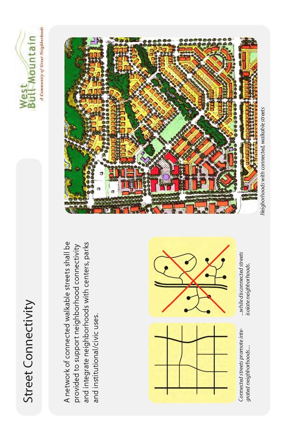
68 62
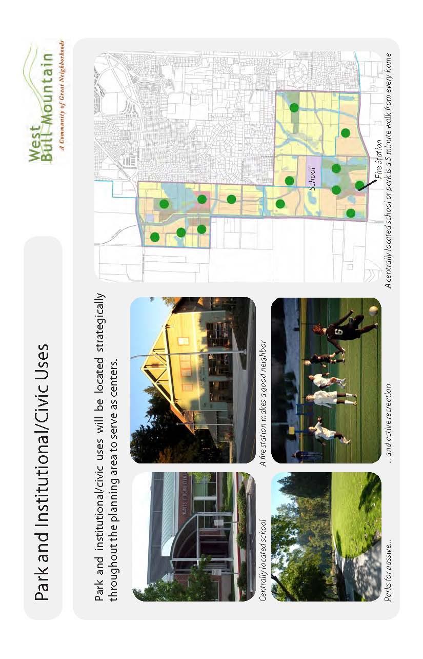
69 63
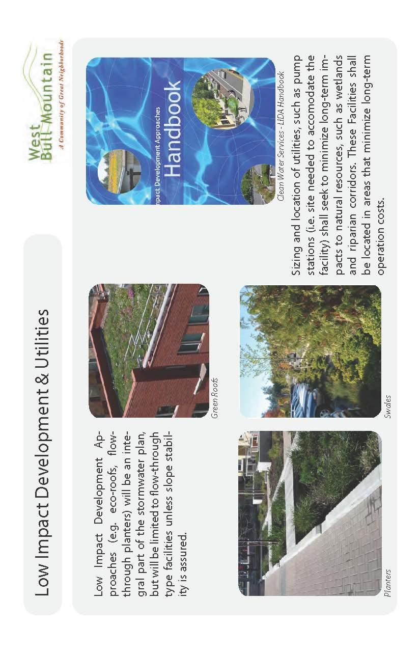
70 64
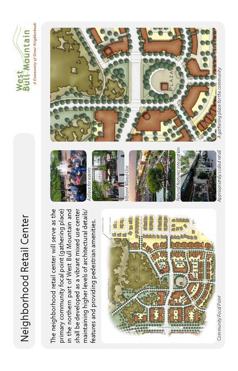
71 65
CITY OF TIGARD EXPECTED SERVICE AREA
 CITY OF TIGARD EXPECTED SERVICE AREA City overview / Background Incorporated in 1961, the has experienced rapid growth over the years. This growth can be attributed to many factors, primarily the close
Westbound: A One-day Exploration of Growth
 Westbound: A One-day Exploration of Growth Frog Pond Area 2018 UGB Expansion Proposal June 13, 2018 Growing Out: UGB Asks Four cities submitted proposals to expand greater Portland s urban footprint by
WASHINGTON COUNTY OREGON
 WASHINGTON COUNTY OREGON LONG RANGE PLANNING DIVISION North Bethany Subarea Stream Corridors: Existing Regulations In Oregon, there is a distinct difference between the land use rules that apply in rural
Ten Mile Creek Planning Area
 PLANNING AREA POLICIES TEN MILE CREEK Ten Mile Creek Planning Area Location and Context The Ten Mile Creek Planning Area ( Ten Mile Creek area ) is located south of the current Boise AOCI, generally south
COLVER ROAD INDUSTRIAL CONCEPT PLAN
 COLVER ROAD INDUSTRIAL CONCEPT PLAN A CONCEPTUAL LAND USE AND TRANSPORTATION PLAN FOR TA-4 AN URBAN RESERVE AREA OF THE CITY TALENT City of Talent Adopted by City Council Resolution No., June, 2015 PART
Applicant Name Phone / Fax / Address City State Zip Code . Property Owner Phone / Fax / Address City State Zip Code
 Master Development Plan Application Community Development Department City of Redmond 411 SW 9 th Street Redmond, Oregon 97756 541-923-7721 541-548-0706 FAX Master Development Plan Fee $38,862.52 File Number
This page intentionally blank.
 This page intentionally blank. Parks, Recreation, and Open Space Chapter Relationship to Vision Vision Parks, Recreation and Open Space Chapter Concepts County Government. County government that is accountable
WASHINGTON COUNTY OREGON
 WASHINGTON COUNTY OREGON July 9, 2009 Revisions to Chapter 2 of the Bethany Community Plan The North Bethany Subarea Plan Exhibit pages 7 and 8 The sections for the Core and Flexible Streets were amended
Rural Land Use Designations Kittitas County December 6, 2007 Draft
 KITTITAS COUNTY COMMUNITY DEVELOPMENT SERVICES 411 N. Ruby St., Suite 2, Ellensburg, WA 98926 CDS@CO.KITTITAS.WA.US Office (509) 962-7506 Fax (509) 962-7682 Rural Land Use Designations Kittitas County
POLICY 41, URBAN GROWTH BOUNDARY EXPANSIONS:
 POLICY 41, URBAN GROWTH BOUNDARY EXPANSIONS: It is the policy of Washington County to ensure an efficient and effective transition of rural land to urban development when an Urban Growth Boundary (UGB)
Location. Need GOAL 14 URBAN GROWTH BOUNDARY. Urban Planning in Oregon 7/8/2015
 Urban Planning in Oregon June 24, 2015 Redmond, Oregon Gordon Howard, DLCD Urban Planning Specialist GOAL 14 URBAN GROWTH BOUNDARY To provide for an orderly and efficient transition from rural to urban
BROOKHILL NEIGHBORHOOD MODEL ZONING MAP AMENDMENT PREFACE TO APPLICATION
 BROOKHILL NEIGHBORHOOD MODEL ZONING MAP AMENDMENT PREFACE TO APPLICATION June 15, 2015 Revised: August 1, 2016 I. VISION Brookhill is a proposed community based upon the principles of Albemarle County
S A C R A M E N T O C O U N T Y JACKSON HIGHWAY & GRANT LINE EAST VISIONING STUDY
 JACKSON HIGHWAY & GRANT LINE EAST S A C R A M E N T O C O U N T Y P L A N N I N G D E P A R T M E N T SUMMARY AND WORKBOOK November 19, 2008 History of the Visioning Study Sacramento County has two growth
SAN RAFAEL GENERAL PLAN 2040 INTRODUCTION AND OVERVIEW
 SAN RAFAEL GENERAL PLAN 2040 INTRODUCTION AND OVERVIEW Steering Committee Presentation February 14, 2018 Purpose of General Plan Guide land use and development decisions Coordinate transportation, infrastructure,
Gold Line Bus Rapid Transit Transit Oriented Development (BRTOD) Helmo Station Area Plan
 Helmo Station Area Plan") Appendix F Gold Line Bus Rapid Transit Transit Oriented Development (BRTOD) Helmo Station Area Plan Introduction and Purpose of the Plan The Gold Line Bus Rapid Transit facility is an eleven-mile dedicated
Appendix F Gold Line Bus Rapid Transit Transit Oriented Development (BRTOD) Helmo Station Area Plan Introduction and Purpose of the Plan The Gold Line Bus Rapid Transit facility is an eleven-mile dedicated
PSRC REVIEW REPORT & CERTIFICATION RECOMMENDATION
 PSRC REVIEW REPORT & CERTIFICATION RECOMMENDATION KITSAP COUNTY COUNTYWIDE PLANNING POLICIES July 2, 2012 BACKGROUND A major emphasis of the Washington State Growth Management Act (GMA) is the need to
Plan Overview. Manhattan Area 2035 Reflections and Progress. Chapter 1: Introduction. Background
 Plan Overview The Manhattan Urban Area Comprehensive Plan (the Comprehensive Plan) is a joint planning initiative of the City of Manhattan, Pottawatomie County, and Riley County. The 2014 Comprehensive
Concord Community Reuse Project Goals and Guiding Principles. Overarching Goals (OG)
") Concord Community Reuse Project Goals and Guiding Principles Overarching Goals (OG) No priority is implied by the order of presentation of the goals and guiding principles. Overarching goals for the Concord
Concord Community Reuse Project Goals and Guiding Principles Overarching Goals (OG) No priority is implied by the order of presentation of the goals and guiding principles. Overarching goals for the Concord
3. VISION AND GOALS. Vision Statement. Goals, Objectives and Policies
 Vision Statement Queen Creek s interconnected network of parks, trails, open spaces and recreation opportunities provide safe and diverse activities and programs that sustain its unique, small town, equestrian
Mendota Heights 2040 Comprehensive Plan Draft Vers
 4 Parks and Trails The City of Mendota Heights boasts a variety of recreational and open space opportunities. Few cities can claim access to regional trails, riverside and lakeside parks, scenic bluffs
INTRODUCTION PLANNING HISTORY
 INTRODUCTION The Upper Rock Creek Master Plan Area lies in the east central part of Montgomery County. The Master Plan Area is adjacent to the City of Rockville to the south, the Olney Planning Area to
CITY OF CHARLOTTESVILLE, VIRGINIA CITY COUNCIL AGENDA
 CITY OF CHARLOTTESVILLE, VIRGINIA CITY COUNCIL AGENDA Agenda Date: December 16, 2013 Action Required: Adoption of Resolution Presenter: Staff Contacts: Title: James E. Tolbert, AICP, Director of NDS James
General Location Annex, Rezone & Preliminary Plat Lansdowne Addition, Unit Three
 NEWFOUNDLAND I-5 Agricultural District Subject Site SUNDANCE ANDERSON Single Family Residential CHRISTY PUD Agricultural District Highway Business General Location Annex, Rezone & Preliminary Plat Lansdowne
City of Redmond. Urban Holding Area Master Planning Requirements and Approval Process
 City of Redmond Urban Holding Area Master Planning Requirements and Approval Process June 21, 2006 City of Redmond: Urban Holding Area Master Planning Requirements and Approval Process Table of Contents
Transportation. Strategies for Action
 Transportation A major priority for the Overlake Neighborhood is to develop a multimodal transportation system. To achieve this system, a balance has to be found among travel, circulation and access needs;
Town of Portola Valley General Plan. Nathhorst Triangle Area Plan
 Town of Portola Valley General Plan Amended December 10, 1997 Table of Contents Introduction... 1 Planning Area... 1 Objectives... 2 Principles... 2 Standards... 4 Description... 4 Community Commercial...
Section 4 BUILDING THE MASTER PLAN
 The Master Plan 33 Section 4 BUILDING THE MASTER PLAN Figure 4:1. A collaborative effort characterized the two design workshops sponsored by DISC to create hypothetical Master Plans for the Towers Property
Chapter 5: Natural Resources and Environment
 NATURAL RESOURCES AND ENVIRONMENT 5-1 5 Chapter 5: Natural Resources and Environment BACKGROUND AND INTENT Urban expansion represents the greatest risk for the future degradation of existing natural areas,
DEVELOPMENT FRAMEWORK POST 2030 LAND USE PLAN INTRODUCTION
 INTRODUCTION Oak Grove s Comprehensive Plan identifies a future Metropolitan Urban Service Area (MUSA). The Metropolitan Council does not anticipate extending utilities to this area prior to 2030. The
ARTICLE 6: Special and Planned Development Districts
 ARTICLE 6: Special and Planned Development Districts 6-10 Traditional Neighborhood Development (TND) District 6-10.10 Purpose and Intent The Traditional Neighborhood Development (TND) District provides
2025 COMPREHENSIVE PLAN PASCO COUNTY, FLORIDA
 GOAL FLU 6: PASADENA HILLS FUTURE LAND USE: PASADENA HILLS AREA PLAN GOALS, OBJECTIVES, AND POLICIES PASADENA HILLS AREA PLAN: OVERVIEW The Pasadena Hills Area Plan Goals, Objectives, and Policies are
Clackamas County Comprehensive Plan. Chapter 4: LAND USE
 Chapter 4: LAND USE When the pioneers settled Clackamas County, the land resource appeared infinite. They cleared forest, carved towns from the wilderness, and used waterways as the arterials of commerce.
OP Council Resolution June 16, Planning and Development Services
 OP-08-01 Council Resolution June 16, 2008 Planning and Development Services Kingsgate Landing Outline Plan Table of Contents 1.0 Introduction 1 1.1 Purpose of Plan 1 1.2 Plan Area Location 1 1.3 Ownership
Chapter 2: Vision, Goals and Strategies
 Chapter 2: Vision, Goals and Lake Elmo Today & Tomorrow Comprehensive Plan 2040 2 VISION, GOALS & STRATEGIES - DRAFT 4-6-2018 INTRODUCTION Comprehensive Plan Purpose Perhapse the most important objective
Complete Neighbourhood Guidelines Review Tool
 Complete Neighbourhood Guidelines Review Tool Prepared By: City of Regina Planning Department October 2014 Page 1 of 14 Community Development Review Checklist for Secondary Plans and Concept Plans The
6 Growth Management Challenges and Opportunities
 6 Growth Management Challenges and Opportunities The Town has established a goal of attaining a 50% participation rate with respect to employment opportunities versus residential population. The Town s
City of Heath. Town Center Concept
 In the give-and-take of getting projects designed, financed, and approved, the famous refrain from the film Field of Dreams is heard often: if you build it, they will come. From the perspective of the
ARTICLE IV: DEVELOPMENT STANDARDS 404 MASTER PLANNING
 IV 13 404 MASTER PLANNING Master Planning through the Site Analysis (Master Planning Site Analysis) or Planned Development (Master Planning Planned Development) is provided to encourage development which
CHAPTER 7: VISION AND ACTION STATEMENTS. Noble 2025 Vision Statement
 CHAPTER 7: VISION AND ACTION STATEMENTS This chapter presents the vision, policy and action statements that transform the comprehensive planning study, an analysis of Noble s past, future trends and community
Living in Albemarle County s Urban Places
 Living in Albemarle County s Urban Places ALBEMARLE COUNTY, VIRGINIA A Closer Look at Albemarle s Approach to Managing Growth and Creating Quality Urban Environments www.albemarle.org Page 2 Living in
RECREATION AND OPEN SPACE ELEMENT GOALS, OBJECTIVES, AND POLICIES
 RECREATION AND OPEN SPACE ELEMENT GOALS, OBJECTIVES, AND POLICIES Goal 7 To provide park facilities, recreation programs, and open space resources that are safe, adequate, and accessible to all City residents,
Midtown Greenway Land Use and Development Plan Executive Summary
 Midtown Greenway Land Use and Development Plan Executive Summary Introduction The Midtown Greenway Land Use and Development Plan sets policy direction for land use and development in the Midtown Greenway
CHAPTER 3 VISION, GOALS, & PLANNING PRINCIPLES. City of Greensburg Comprehensive Plan. Introduction. Vision Statement. Growth Management Goals.
 CHAPTER 3 VISION, GOALS, & PLANNING PRINCIPLES Introduction The Greensburg Comprehensive Plan is intended as a working community document. A combination of long and short-term goals, this document is intended
TABLE OF CONTENTS. Transportation Chapter 1 - Introduction and Purpose of Planning to 1-3. Utilities
 Chapter 1 - Introduction and Purpose of Planning... 1-1 to 1-3 Pennsylvania Municipalities Planning Code (Act 247)...1-1 Previous County Planning Activities...1-1 Objectives of the Plan...1-2 Elements
Overview of the Plan. The Building Blocks of Centers, Neighborhoods and Network INTERNAL DRAFT
 Overview of the Plan 4 East Davidson Ramah Church Rd June Washam Rd Bradford District Park Bradford Shearer Rd Campus District NC 73 Davidson-Concord North Rocky River This Master Plan projects an approximate
Town of Peru Comprehensive Plan Executive Summary
 Town of Peru Comprehensive Plan Executive Communities that plan grow by choice, not by chance. A plan makes growth thoughtful, understandable, and predictable. A plan shows that a community is managing
CITY OF ANN ARBOR MASTER PLAN. Land Use Element
 CTY OF ANN ARBOR MASTER PLAN Land Use Element June 15, 2009 Prepared by the Ann Arbor City Planning and Development Services Unit and the City of Ann Arbor Planning Commission City Master Plan: Land Use
CHUGIAK-EAGLE RIVER SITE-SPECIFIC LAND USE PLAN
 CHUGIAK-EAGLE RIVER SITE-SPECIFIC LAND USE PLAN JUNE 2010 Final Prepared for The Heritage Land Bank, Municipality of Anchorage by Agnew: :Beck Consulting www.agnewbeck.com 907.222.5424 Chugiak-Eagle River
Appendix C: Interim Mixed-Use Evaluation Criteria
 Appendix C: Interim Mixed-Use Evaluation Criteria C-1 Appendix C: Interim Mixed-Use Evaluation Criteria PURPOSE: The implementation of numerous policies contained within the Master Plan hinges on the creation
Woodburn Comprehensive Plan Growth Management Goals and Policies
 Goal Woodburn Comprehensive Plan Growth Management Goals and Policies G-1. The City's goal is to manage growth in a balanced, orderly and efficient manner, consistent with the City s coordinated population
Town Center (part of the Comprehensive Plan)
") Town Center (part of the Comprehensive Plan) Mercer Island Town Center Looking North (2014) In 1994, a year-long process culminated in a set of design guidelines and code requirements for the Town Center
Town Center (part of the Comprehensive Plan) Mercer Island Town Center Looking North (2014) In 1994, a year-long process culminated in a set of design guidelines and code requirements for the Town Center
Glenborough at Easton Land Use Master Plan
 Land Use Framework November 30, 2007 2.0 LAND USE FRAME- WORK 2.1 LAND USE HISTORY and Setting Glenborough at Easton is located on property that was used for mining in the 19th and 20th centuries and rocket
2.7 ac park. TOTAL 5,403 DU 1,297,900 sf 1,105,450 sf 3.87 ac 5,563 DU 1,121,200 sf 1,105,450 sf 3.87 ac
 PLAN AMENDMENT 2013-I-B1: SEVEN CORNERS SPECIAL STUDY Summary of Pre-staffing Comments Planner: Bernard Suchicital bsuchi@fairfaxcounty.gov (703) 324-1254 Background On October 29, 2013, the Board of Supervisors
A BLUEPRINT FOR BROCKTON A CITY-WIDE COMPREHENSIVE PLAN
 A BLUEPRINT FOR BROCKTON A CITY-WIDE COMPREHENSIVE PLAN Public Meeting October 2016 1 Plan Summary and Discussion Public Meeting May 4 2017 City of Brockton Bill Carpenter, Mayor Department of Planning
Description of Preferred Alternative
 Chapter 2 Description of Preferred Alternative 2.1 Introduction This chapter of the programmatic Sammamish Town Center Sub-area Plan Final EIS provides a more detailed description of the Preferred Alternative
The transportation system in a community is an
 7 TRANSPORTATION The transportation system in a community is an important factor contributing to the quality of life of the residents. Without a sound transportation system to bring both goods and patrons
2025 COMPREHENSIVE PLAN PASCO COUNTY, FLORIDA
 GOAL FLU 6: PASADENA HILLS FUTURE LAND USE: PASADENA HILLS AREA PLAN GOALS, OBJECTIVES, AND POLICIES PASADENA HILLS AREA PLAN: OVERVIEW The Pasadena Hills Area Plan Goals, Objectives, and Policies are
SHEFFIELD PARK Paulding County, GA DRI #588
 SHEFFIELD PARK Paulding County, GA DRI #588 Supplemental Information for RDC s DRI (Form 2) Review August 16, 2004 Prepared for: Mr. David Howerin Coosa Valley RDC 1 Jackson Hill Drive Rome, GA 30161 P.O.
Shoreline Master Program Town of La Conner, Washington
 Shoreline Master Program Town of La Conner, Washington Department of Ecology approval effective Adopted September 24, 2013 by Town of La Conner Ordinance No.1106 Amended May 13, 2014 by Town of La Conner
9 th Street Sub Area Plan
 9 th Street Sub Area Plan In the 1990 s, when the Township prepared the last Master Plan, the 9 th Street corridor was studied as part of a larger 9 th Street Focus Area that included the West Main Street
Land Use Amendment in Southwood (Ward 11) at and Elbow Drive SW, LOC
 at and Elbow Drive SW, LOC") 2018 November 15 Page 1 of 10 EXECUTIVE SUMMARY This land use amendment application was submitted by Rick Balbi Architect on 2017 August 31 on behalf of Sable Developments Ltd, and with authorization from
2018 November 15 Page 1 of 10 EXECUTIVE SUMMARY This land use amendment application was submitted by Rick Balbi Architect on 2017 August 31 on behalf of Sable Developments Ltd, and with authorization from
OVERVIEW OF PLANS FOR THE JEFFERSON COUNTY COUNTRYSIDE FARM In the Context of Quality Place Characteristics
 OVERVIEW OF PLANS FOR THE JEFFERSON COUNTY COUNTRYSIDE FARM In the Context of Quality Place Characteristics By Steve Grabow, Professor and Community Development Educator University of Wisconsin-Extension,
4-Town Comprehensive Plan DRAFT 7/30/07
 4-Town Comprehensive Plan DRAFT 7/30/07 Acknowledgements ning Committee Town of Harrisburg Norman Roof Randy Nicol Town of Martinsburg Terry Thisse Paul Kelly Town of Montague Jan Bagdanowicz Wendy Perry
Whitemarsh Comprehensive Plan Update: Housing & Land Use. Public Workshop #3: September 20, 2018
 Whitemarsh Comprehensive Plan Update: Housing & Land Use Public Workshop #3: September 20, 2018 Agenda Welcome Process Recap What We ve Heard The Plan Framework Review of Recommended Actions Land Use Housing
CITY OF PUYALLUP. Background. Development Services
 CITY OF PUYALLUP Development Services 333 South Meridian Puyallup WA 98371 To: City Council From: Katie Baker, AICP, Planning Division Re: South Hill Neighborhood Plan Adoption Date: (Meeting date: February
A. WHAT IS A GENERAL PLAN?
 I. Introduction A. WHAT IS A GENERAL PLAN? A general plan is the planning guideline for the future of a city. It contains goals and policies which regulate urban development, the protection of the natural
DOMINION BOULEVARD CORRIDOR STUDY AND ECONOMIC DEVELOPMENT STRATEGIC PLAN A MODEL FOR CHESAPEAKE S FUTURE
 DOMINION BOULEVARD CORRIDOR STUDY AND ECONOMIC DEVELOPMENT STRATEGIC PLAN A MODEL FOR CHESAPEAKE S FUTURE Overview I. Draft Plan Process II. Draft Plan Overview a. Market Analysis b. Master Land Use Plan
1. Parks & Recreation Neighborhood Parks Community Parks Special Use Sites 2. Open Space 3. Trails
 Appendix A: Park Classifications The intent of parks and recreation classifications is to aid in making acquisition and design decisions for park sites, facilities and the organization of recreation space
Implementation Guide Comprehensive Plan City of Allen
 Implementation Guide 2030 Comprehensive Plan City of Allen DRAFT 2015 Implementation Guide Allen 2030 Comprehensive Plan INTRODUCTION The Comprehensive Plan serves as a guide for the growth and development
A citizen s guide to the. Comprehensive Plan. City of Lakeville, Minnesota 1
 A citizen s guide to the Comprehensive Plan 2008 City of Lakeville, Minnesota 1 Introduction The City of Lakeville completed an update of its Comprehensive Plan in 2008. A comprehensive plan is a tool
Goal 14 Urbanization
 Urbanization The residents of Benton County value the rural character that still exists in much of the County, the distinction that has been maintained between settlement areas and resource lands and open
COMMISSION ACTION FORM
 ITEM #: 6 DATE: 09-06-17 COMMISSION ACTION FORM REQUEST: Introduction and Initial Review of Proposed Amendments to the Ames Urban Fringe Future Land Map for the North Growth Gap Area BACKGROUND INFORMATION:
Corridor Vision. 1Pursue Minnehaha-Hiawatha Community Works Project. Mission of Hennepin County Community Works Program
 1Pursue Minnehaha-Hiawatha Community Works Project Minnehaha-Hiawatha Community Works is a project within the Hennepin Community Works (HCW) program. The mission of the HCW program is to enhance how the
OVERMOUNTAIN VICTORY TRAIL BURKE CALDELL CORRIDOR FEASIBLITY STUDY REQUEST FOR QUALIFICATIONS CALDWELL COUNTY PATHWAYS
 OVERMOUNTAIN VICTORY TRAIL BURKE CALDELL CORRIDOR FEASIBLITY STUDY REQUEST FOR QUALIFICATIONS CALDWELL COUNTY PATHWAYS Caldwell County Pathways along with our co-partners City of Lenoir, Town of Gamewell,
SECTION 1 Introduction...1. SECTION 2 Regional Context Criteria for Planning Districts Description of Planning District...
 Table of Contents SECTION 1 Introduction...1 SECTION 2 Regional Context...2 2.1 - Criteria for Planning Districts...2 2.2 - Description of Planning District...2 SECTION 3 Goals & Objectives...5 SECTION
Regional Context Statement
 Regional Context Statement REGIONAL CONTEXT STATEMENT 3. REGIONAL CONTEXT STATEMENT In 1995, the Provincial Government passed into law the Growth Strategies Act. The purpose of this provincial initiative
1.0 Introduction. Purpose and Basis for Updating the TMP. Introduction 1
 1.0 Introduction The Town of Castle Rock is situated between the metropolitan areas of Denver and Colorado Springs, amidst a unique terrain of rolling hills, mesas, ravines, and waterways. Like many Front
PLAN ON A PAGE SUMMARY
 Questions? Please Call - 423-989-5518. PLAN ON A PAGE SUMMARY The Plan on a Page is a tool for the City of Bristol to engage Bristol s neighborhoods, community organizations, and interest groups to organize
Preliminary Plan Framework: Vision and Goals
 Preliminary Plan Framework: Vision and Goals Draft: May 2015 Introduction Since the Town of Milliken s comprehensive plan was last updated in 2010, the community was heavily impacted by the 2013 flood,
2018 Northampton Township Comprehensive Plan
 2018 BUCKS COUNTY, PENNSYLVANIA What is a? A comprehensive plan is a municipality s main policy document that details the collective vision for the future, the historic, environmental, and cultural facilities
City of Nogales General Plan
 Open Space, Parks, Recreation and Trails City of Nogales General Plan Residents of Nogales place a high priority in the development of a comprehensive system of open space, parks, recreation and trails
Municipal Plan*Assessment
 Municipal Plan*Assessment This tool was developed to assist in reviewing municipal master plans and in determining if these plans are consistent with smart growth principles, neighboring municipal plans,
Public may provide comments on the GDP within the next two weeks (December 24)
") 25/70 General Development Plan (GDP) Public Meeting Wednesday, December 10, 2014 6:00 8:00 P.M. District 1 Police Station Community Room 1311 W 46th Ave, Denver, CO 80211 Council Woman Montero: This particular
25/70 General Development Plan (GDP) Public Meeting Wednesday, December 10, 2014 6:00 8:00 P.M. District 1 Police Station Community Room 1311 W 46th Ave, Denver, CO 80211 Council Woman Montero: This particular
Planning Board Briefing
 Planning Board Briefing Why Now? The Sector Plan Implementation Chapter States: Before Stage 1 begins, the following must occur: Approval of the Sectional Map Amendment. Approval of the Greater Lyttonsville
Chapter 1: Introduction
 Chapter 1: Introduction The Penn Avenue Community Works Corridor Vision and Implementation Framework presents an integrated communitybased vision and a coordinated, long-term implementation framework for
Report to: Development Services Committee Report Date: April 24, 2017
 SUBJECT: Cornell Rouge National Urban Park Gateway - Report on Design Charrette and Next Steps PREPARED BY: Lilli Duoba, MES, MCIP, RPP, Manager, Natural Heritage (ext. 7925) REVIEWED BY: Marg Wouters,
Mitchell Ranch South MPUD Application for Master Planned Unit Development Approval Project Narrative. Introduction
 Mitchell Ranch South MPUD Application for Master Planned Unit Development Approval Project Narrative Introduction Mitchell Ranch South is a proposed single family (detached) residential development on
S C O P E O F W O R K A P R I L
 white flint 2 sector plan S C O P E O F W O R K A P R I L 2 0 1 2 MONTGOMERY COUNTY PLANNING DEPARTMENT M-NCPPC MontgomeryPlanning.org 1 white flint 2 sector plan Scope of Work abstract This scope of work
COUNTY-WIDE PLANNING POLICIES
 Thurston County COUNTY-WIDE PLANNING POLICIES November 10, 2015 These policies were adopted by the Board of County Commissioners on September 8, 1992. They were ratified earlier by each of the seven cities
Courthouse Square Planning & Urban Design Study. Courthouse Square Working Group #13 October 15, 2014
 Courthouse Square Planning & Urban Design Study Courthouse Square Working Group #13 October 15, 2014 1 Courthouse Square Process Working Group Community Courthouse Square Advisory Groups & Civic Associations
Glenborough at Easton Land Use Master Plan
 Vision Statement Sunrise Blvd. Hazel Ave. Prairie City Rd. Gencorp Property Lincoln Regional Airport 1.0 VISION STATEMENT The identifies City of the principles, goals, policies, and standards Lincoln that
2040 LUP is a part of the Comprehensive Plan and carries the same legal authority. Economic Challenges
 1.1. Guiding Anchorage s Growth Where will new residents settle over the next two decades? Where will people work, shop, and play? Will there be enough room to grow? How will Anchorage look? Will growth
North Fair Oaks Community Plan Summary and Information
 North Fair Oaks Community Plan Summary and Information WHAT IS THE NORTH FAIR OAKS COMMUNITY PLAN? The North Fair Oaks Community Plan is part of the San Mateo County General Plan, and establishes policies
Staff Report and Recommendation
 Community Planning and Development Planning Services 201 W. Colfax Ave., Dept. 205 Denver, CO 80202 p: 720.865.2915 f: 720.865.3052 www.denvergov.org/cpd TO: City Council Neighborhoods and Planning Committee
CHAPTER 4 FUTURE LAND USE AND URBAN SERVICES DISTRICTS
 CHAPTER 4 FUTURE LAND USE AND URBAN SERVICES DISTRICTS Introduction This chapter discusses how Benzie County should grow and change in the future. A community can grow and change in many different ways.
CHAPTER 12 IMPLEMENTATION
 CHAPTER 12 IMPLEMENTATION The 2010 Town of Denton Comprehensive Plan is intended to capture a vision of the future of Denton. As such, it provides a basis for a wide variety of public and private actions
EXECUTIVE SUMMARY DRAFT CHAPTER 1 INTRODUCTION EXECUTIVE SUMMARY
 CHAPTER 1 EXECUTIVE SUMMARY INTRODUCTION Through the joint efforts of the City of Tulsa planning staff and the Land Services division of Indian Nations Council of Governments (INCOG), the Berryhill Land
Secrest Short Cut and Monroe Expressway Small Area Plan AUGUST 29, 2018
 Secrest Short Cut and Monroe Expressway Small Area Plan AUGUST 29, 2018 Background and Process Monroe Expressway will be open by the end of 2018 Union County and Indian Trail identified a need to revisit
I. INTRODUCTION. Project Background and Study Area
 I. INTRODUCTION Project Background and Study Area Freedom Parkway is a key east-west corridor connecting I-25 on the west to the Town of Kersey on the east, running approximately one to two miles south
7Page 1 CLEMMONS COMMUNITY COMPASS 1 PLAN OVERVIEW
 1 Plan Overview WHAT IS I THE CLEMMONS COMMUNITY COMPASS? The Clemmons Community Compass is our community s comprehensive plan. It serves as our blueprint and provides direction for the future of the Village