Kuruman Power Line, Northern Cape Province
|
|
|
- Lucy Tucker
- 5 years ago
- Views:
Transcription
1 Report Kuruman Power Line, Northern Cape Province Mitha Cilliers (Pr LArch) Newtown Landscape Architects

2 PROPOSED KURUMAN POWER LINE UPGRADE PROJECT, NORTHERN CAPE PROVINCE Submitted to: Zitholele Consulting (PTY) LTD Building 1 Maxwell Office Park Magwa Crescent West Waterfall City, Midrand Contact No.: Prepared by: Newtown Landscape Architects cc PO Box 36 Fourways 2055 graham@newla.co.za NLA Project No: 1918/V14NC Report Revision No: Final Date Issued: 19 Prepared By: Mitha Cilliers (Pr LArch) Reviewed By: Yonanda Martin NLA Reference: Kuruman Power Line i
3 EXPERTISE OF SPECIALISTS Name: Qualification: Professional Registration: Experience in Years: Experience Graham A Young Pr LArch South African Council for the Landscape Architectural Profession (SACLAP) Institute of Landscape Architects of South Africa (ILASA) 30 years Graham is a landscape architect with thirty years experience. He has worked in Southern Africa and Canada and has valuable expertise in the practice of landscape architecture, urban design and environmental planning. He is also a senior lecturer, teaching urban design and landscape architecture at post and under graduate levels at the University of Pretoria. He specializes in s and has won an Institute of Landscape Architects Merit Award for his VIA work. Name Qualification Professional Registration Experience in Years Experience Mitha Cilliers Pr LArch South African Council for the Landscape Architectural Profession (SACLAP) 10 years Mitha has worked as Landscape Architect in South Africa and Angola and has valuable expertise in the practice of landscape architecture and environmental planning. She has been working on visual impact assessments for Newtown Landscape Architects since Her experience comprises of a wide range of visual impact assessments including game lodges, transmission lines, solar parks and mines. ii
4 Acronyms, Abbreviations and Glossary ACRONYMS, ABBREVIATIONS & GLOSSARY Acronyms & Abbreviations CAD DTM EIA EMP GIS IFC ILASA NEMA NLA SACLAP VIA Computer-aided design Digital Terrain Model Environmental Impact Assessment Environmental Management Plan Geographic Information System International Finance Corporation Institute for Landscape Architecture in South Africa National Environmental Management Act Newtown Landscape Architects South African Council for the Landscape Architectural Profession iii
5 Acronyms, Abbreviations and Glossary Glossary Aesthetic Value Aesthetically place significant Aesthetic value is the emotional response derived from the experience of the environment with its particular natural and cultural attributes. The response can be either to visual or non-visual elements and can embrace sound, smell and any other factor having a strong impact on human thoughts, feelings and attitudes (Ramsay, 1993). Thus aesthetic value encompasses more than the seen view, visual quality or scenery, and includes atmosphere, landscape character and sense of place (Schapper, 1993). A formally designated place visited by recreationists and others for the express purpose of enjoying its beauty. For example, tens of thousands of people visit Table Mountain on an annual basis. They come from around the country and even from around the world. By these measurements, one can make the case that Table Mountain (a designated National Park) is an aesthetic resource of national significance. Similarly, a resource that is visited by large numbers who come from across the region probably has regional significance. A place visited primarily by people whose place of origin is local is generally of local significance. Unvisited places either have no significance or are "no trespass" places. (after New York, Department of Environment 2000). Aesthetic impact Cumulative Effects Landscape Character Landscape Impact Aesthetic impact occurs when there is a detrimental effect on the perceived beauty of a place or structure. Mere visibility, even startling visibility of a project proposal, should not be a threshold for decision making. Instead a project, by virtue of its visibility, must clearly interfere with or reduce (i.e. visual impact) the public's enjoyment and/or appreciation of the appearance of a valued resource e.g. cooling tower blocks a view from a National Park overlook (after New York, Department of Environment 2000). The summation of effects that result from changes caused by a development in conjunction with the other past, present or reasonably foreseeable actions. The individual elements that make up the landscape, including prominent or eye-catching features such as hills, valleys, woods, trees, water bodies, buildings and roads. They are generally quantifiable and can be easily described. Landscape effects derive from changes in the physical landscape, which may give rise to changes in its character and how this is experienced (Institute of Environmental Assessment & The Landscape Institute, 1996). iv
6 Acronyms, Abbreviations and Glossary Study area For the purposes of this report the Study area refers to the proposed project footprint / project site as well as the zone of potential influence (the area defined as the radius about the centre point of the project beyond which the visual impact of the most visible features will be insignificant) which is a 15 km radius surrounding the proposed project footprint / site. Project Footprint / Site For the purposes of this report the site / footprint refers to a 1km wide buffer along the length of the proposed power line alternatives. Sense of Place (genius loci) Sensitive Receptors Viewshed analysis Visibility Visual Exposure Visual Impact Visual Intrusion Worst-case Scenario Zone of Potential Visual Influence Sense of place is the unique value that is allocated to a specific place or area through the cognitive experience of the user or viewer. Genius loci literally means spirit of the place. Sensitivity of visual receptors (viewers) to a proposed development. The two dimensional spatial pattern created by an analysis that defines areas, which contain all possible observation sites from which an object would be visible. The basic assumption for preparing a viewshed analysis is that the observer eye height is 1,8 m above ground level. The area from which project components would potentially be visible. Visibility depends upon general topography, aspect, tree cover or other visual obstruction, elevation and distance. Visibility and visual intrusion qualified with a distance rating to indicate the degree of intrusion and visual acuity, which is also influenced by weather and light conditions. Visual effects relate to the changes that arise in the composition of available views as a result of changes to the landscape, to people s responses to the changes, and to the overall effects with respect to visual amenity. The nature of intrusion of an object on the visual quality of the environment resulting in its compatibility (absorbed into the landscape elements) or discord (contrasts with the landscape elements) with the landscape and surrounding land uses. Principle applied where the environmental effects may vary, for example, seasonally to ensure the most severe potential effect is assessed. By determining the zone of potential visual influence it is possible to identify the extent of potential visibility and views which could be affected by the proposed development. Its maximum extent is the radius around an object beyond which the visual impact of its most visible features will be insignificant primarily due to distance. v
7 Executive Summary EXECUTIVE SUMMARY Background and Project Overview Newtown Landscape Architects (NLA) was appointed by Zitholele Consulting (Pty) Ltd to conduct the visual impact assessment for the proposed upgrade of the 66kV network in the Kuruman area, in Northern Cape Province. The Kuruman Power Line upgrade project is located between the towns of Hotazel, Kuruman and Kathu in the Northern Cape Province. The study area will include the subregion around the Hotazel, Krurman and Kathu towns and the visual analysis will be done on an area up to a width of 1km, 500m on either sides of the power line (as per the Services Offered & Deliverables in the appointment letter). Refer to Figure 1, in the main body of the report, for the Locality Map. Aim of the Specialist Study The main objective of the specialist study is to assess the visual impacts the that would arise from the implementation of the Kuruman Power Line project on the visual environment and determine the preferred alignment for the power line upgrade. The Environmental Setting and Sensitivity The study area lies at the edge of the Khalahari along the main route between Gauteng and Namibia / Cape Town via Upington. Agricultural activities mainly comprise of livestock grazing (cattle, sheep and game) and subsistence farming. The residential component of the study area comprise of the three towns: Hotazel (in the north), Kuruman (in the central area) and Kathu (in the south) with their associated communities as well as farmsteads and workers residences. The study area is also well known for its mining industry with manganese mines in the Hotazel area in the north and iron mines in the south associated with the town of Kathu. Other than all level of roads, transport infrastructure also includes a railway line, mostly linking the mines and transporting mining produce from within the study area to the coast and refinery depots. The landscape character of the study area is mostly defined by the topography and consists of moderately undulating plains, criss-crossed by a network of, mostly dry, water ways. The larger water ways include the Kuruman River, Mathlawaring River, Witleegte dry-run, Vlermuisleegte dry-run and Gamogara River. The study area falls within the western and north-western subdivision of the Kalahari Thornveld, as classified by Acocks. The typical form of this vegetation type is an wide open savanna with white type mostly tufted grasses. The study area has a harsh desolate rural character, degraded by the mining industries around Hotazel and Kathu. At night time, the rural sky will be light up by the mining industries around Hotazel and Kathu, the lights associated with the three towns, the communities as well as those from farmsteads. The scenic value had been rated as moderate due to it being common to the sub-region. Conclusion From the above visual analysis and comparative study the following conclusions can be made with regards the two new substations, Gamohaan and Sekgame: vi
8 Executive Summary The significance of the two new substations were rated as low for the pre-construction phase. For the Construction phase, the existing condition were rated as low while the cumulative and residual condition was rated as high for the Gamoane Substation and moderate for the Sekgame Substation. This was similar for the Operational Phase. In terms of the Decommissioning phase, the existing condition and cumulative impact were rated as moderate and residual impact as low. This is due to the Gamoane Substation being located within a service corridor at the foot of a mountain and near a river its severity had been rated as moderate. While the Sekgame Substation is located within a service corridor near mine dumps, its severity has therefore been rated as low. In terms of the substations and switch station upgrades the following can be concluded: Eldoret Substation: The pre-construction significance ratings are moderate for the existing, cumulative and residual impacts. In terms of Construction the significance for the existing condition was rated low because there are currently no construction activities. The cumulative and residual impacts, were rated moderate, as the construction activities will add nuisance to the existing visual impact. The significance of the existing, cumulative and residual visual impact would be moderate for the Operational phase. The presence of the 132kV substation will continue to exert a nuisance to the existing visual environment. Decommissioning activities would result in a moderate significance for the visual impact on the existing and cumulative conditions. However, the significance of the residual impact would be low. Riries Substation: The pre-construction significance ratings are moderate for the existing, cumulative and residual impacts. In terms of Construction, the significance for the existing condition was rated low because there are currently no construction activities. The cumulative and residual impacts, were rated moderate, as the construction activities will add nuisance to the existing visual impact. The significance of the existing, cumulative and residual visual impact would be moderate for the Operational phase. The presence of the 132kV substation will continue to exert a nuisance to the existing visual environment. Decommissioning activities would result in a moderate significance for the visual impact on the existing and cumulative conditions. However, the significance of the residual impact would be low. Mothibistat Substation: The pre-construction significance ratings are moderate for the existing, cumulative and residual impacts. In terms of Construction, the significance for the existing condition was rated low because there are currently no construction activities. The cumulative and residual impacts, were rated moderate, as the construction activities will add nuisance to the existing visual impact. The significance of the existing, cumulative and residual visual impact would be moderate for the Operational phase. The presence of the 132kV substation will continue to exert a nuisance to the existing visual environment. Decommissioning activities would result in a moderate significance for the visual impact on the existing and cumulative conditions. However, the significance of the residual impact would be low. Moffat Substation: The pre-construction significance ratings are moderate for the existing, cumulative and residual impacts. In terms of Construction, the significance for the existing vii
9 Executive Summary condition was rated low because there are currently no construction activities. The cumulative and residual impacts, were rated moderate, as the construction activities will add nuisance to the existing visual impact. The significance of the existing, cumulative and residual visual impact would be moderate for the Operational phase. The presence of the 132kV substation will continue to exert a nuisance to the existing visual environment. Decommissioning activities would result in a moderate significance for the visual impact on the existing and cumulative conditions. However, the significance of the residual impact would be low. Valley Substation: The pre-construction significance ratings are moderate for the existing, cumulative and residual impacts. In terms of Construction, the significance for the existing condition was rated low because there are currently no construction activities. The cumulative and residual impacts, were rated moderate, as the construction activities will add nuisance to the existing visual impact. The significance of the existing, cumulative and residual visual impact would be moderate for the Operational phase. The presence of the 132kV substation will continue to exert a nuisance to the existing visual environment. Decommissioning activities would result in a moderate significance for the visual impact on the existing and cumulative conditions. However, the significance of the residual impact would be low. The findings of the comparative visual analysis for the upgrade of the power line between Hotzael, Kuruman and Kathu can be concluded as follows: Hotazel Eldoret: Alternative 2 is the preferred alternative for this segment as it has a greater distance along service corridors, lesser distance through virgin land and has no residential unit incidence. Eldoret Riries: Alternative 2 runs for its entire length along an existing power line is therefore the preferred alternative for this segment. Riries Gamohaan: Alternative 1 is the preferred alternative for this segment as it runs for its entire length along a road and passes on the opposite side of the road along the Maheana community. Gamohaan Mothibistat: Alternative 1 is the preferred alternative for this segment as it has a shorter total distance, shorter distance through virgin land and passes adjacent the residential area of Kuruman. Mothibistat Moffat: Alternative 1 is the preferred alternative for this segment as it runs along an existing power line for its entire length. Even though it passes 100m and 200m from guest lodges, these are already exposed to the negative visual impact from the existing power line. Moffat Valley: Even though Alternative 1 has more incidences with residential units and a greater total distance it is the preferred alternative of the two. Most of the residential units are already exposed to the negative visual impact of the existing power line. Alternative 1 has the greater distance along existing power lines and the lesser distance through virgin lands and sensitive landscapes. viii
10 Executive Summary Valley Sekgame: This segment has four alternatives. The preferred alternative is Alternative 4. The second preferred alternative is Alternative 1. Alternative 2 is the second least and Alternative 3 the least preferred alternative. Alternative 4 it the preferred alternative even though it has the third longest total distance of the four alternatives. It was the preferred alternative in two sets of the criteria as well as the second preferred in another two sets of criteria. ix
11 Executive Summary x

12 Executive Summary xi
13 Table of Content TABLE OF CONTENTS 1. INTRODUCTION Background and Project Overview Locality and Study Area Objective of the Specialist Study Terms and Reference Assumption, Uncertainties and Limitations 2 2. LEGAL REQUIREMENTS AND GUIDELINES National Guidelines International Guidelines 4 3. APPROACH AND METHODOLOGY Approach The Visual Resource Sensitivity of Visual Resource Sense of Place Sensitive Landscape and Viewer Locations Landscape Impact Visual Impact (not applicable at this stage) Severity of Visual Impact (not applicable at this stage) Significance of Visual Impact (not applicable at this stage) Methodology 9 4. DESCRIPTION OF THE PROJECT THE ENVIRONMENTAL SETTING AND SENSITIVITY The Study area Residential Agriculture Tourism Mining and Industrial Transportation systems and infrastructure Landscape Character VISUAL RESOURCE Sense of Place Visual Resource Value / Scenic Quality / Landscape Sensitivity VISUAL RECEPTORS Visual Receptors Potential Sensitivity of the Visual Receptors VISUAL IMPACT ASSESSMENT OF THE PROPOSED NEW GOMOANE AND SEKGAME SUBSTATIONS Visual Intrusion Visibility and Visual Exposure 29 xii
14 Table of Content 8.3 Severity of the Visual Impact and Impact on the Sense of Place Significance of the Visual Impacts form the Gamoane and Sekgame Substations Mitigation Measures for the Gamoane and Sekgame Substations Pre-Construction Phase Construction Phase Operational Phase Decommissioning Phase VISUAL IMPACT ASSESSMENT OF THE PROPOSED SUBSTATION AND SWITCHING STATION UPGRADES Eldoret Substation Riries Substation Mothibistat Substation Moffat Substation Valley Substation Mitigation Measures for the Substation Upgrades VISUAL IMPACT ASSESSMENT OF THE PROPOSED POWER LINE ALTERNATIVES Hotazel Eldoret Power Line Eldoret Riries Power Line Riries Gamohaan Power Line Gamohaan Mothibistat Power Line Mothibistat Moffat Power Line Moffat Valley Power Line Valley Sekgame Power Line Mitigation Measures for the Substation Upgrades CONCLUSION REFERENCES 86 APPENDIX A: DETERMINING A LANDSCAPE AND THE VALUE OF THE VISUAL RESOURCE 87 APPENDIX B: METHOD FOR DETERMINING THE INTENSITY OF LANDSCAPE AND VISUAL IMPACT 92 APPENDIX C: SIGNIFICANCE RATING METHODOLOGY Nature of the impact Extent of the impact Duration of the impact Potential intensity of the impact Likelihood of the impact Cumulative Impacts Significance Assessment Notation of Impacts 105 xiii
15 Table of Content APPENDIX D: DECLERATION OF INDEPENDENCE 106 APPENDIX E: CURRICULUM VITAE 107 xiv
16 List of Figures LIST OF FIGURES Figure 1 Figure 2 Figure 3.1 to 3.8 Figure 4.1 Figure 4.2 Locality Project Components Landscape Character Landscape Sensitivity Northern Section (Hotazel Kuruman) Landscape Sensitivity Southern Section (Kuruman Kathu) Figure 5.1 Photo Simulation 1 Figure 5.2 Photo Simulation 2 xv
17 List of Tables LIST OF TABLES Table 1 Value of the Visual Resource Table 2 Potential Sensitivity of Visual Receptors Table 3 Visual Intrusion of Gomoane and Sekgame Substations Table 4 Visual Exposure of the Sensitive Viewer Locations to the Gomoane Substation Table 5 Visual Exposure of the Sensitive Viewer Locations to the Sekgame Substation Table 6 Severity of Impact of the Gomoane and Sekgame Substations Table 7.1 Significance of Visual Impact from the Gomoane and Sekgame Substations Pre- Construction Phase Table 7.2 Significance of Visual Impact from the Gomoane and Sekgame Substations Construction Phase Table 7.3 Significance of Visual Impact from the Gomoane and Sekgame Substations Operation Phase Table 7.4 Significance of Visual Impact from the Gomoane and Sekgame Substations Decommissioning Phase Table 8.1 Significance of Visual Impact from the Substations to be Upgraded - Pre- Construction Phase Table 8.2 Significance of Visual Impact from the Substations to be Upgraded - Construction Phase Table 8.3 Significance of Visual Impact from the Substations to be Upgraded - Operational Phase Table 8.4 Significance of Visual Impact from the Substations to be Upgraded - Decommissioning Phase Table 9.1 Hotzael Eldoret Power Line Alternatives 1 and 2 Table 9.2 Eldoret - Rieries Power Line Alternatives 1 and 2 Table 9.3 Rieries - Gamohaan Power Line Alternatives 1 and 2 Table 9.4 Gamohaan Mothibistat Power Line Alternatives 1 and 2 Table 9.5 Mothibistat Moffat Power Line Alternatives 1 and 2 xvi
18 List of Tables Table 9.6 Moffat Valley Power Line Alternatives 1 and 2 Table 9.7 Valley Sekgame Power Line Alternatives 1 to 4 Table 10.1 Table 10.2 Table 10.3 Table 10.4 Significance of Visual Impact from the Power Line Alternatives - Pre-Construction Phase Significance of Visual Impact from the Power Line Alternatives - Construction Phase Significance of Visual Impact from the Power Line Alternatives - Operational Phase Significance of Visual Impact from the Power Line Alternatives - Decommissioning Phase xvii
19 1. INTRODUCTION Introduction 1.1 Background and Project Overview Newtown Landscape Architects (NLA) was appointed by Zitholele Consulting (Pty) Ltd to conduct the visual impact assessment for the proposed upgrade of the 66kV network in the Kuruman area, in Northern Cape Province. 1.2 Locality and Study Area The Kuruman Power Line upgrade project is located between the towns of Hotazel, Kuruman and Kathu in the Northern Cape Province. The study area will include the subregion around the Hotazel, Krurman and Kathu towns and the visual analysis will be done on an area up to a width of 1km, 500m on either sides of the power line (as per the Services Offered & Deliverables in the appointment letter). Refer to Figure 1 for the Locality Map. 1.3 Objective of the Specialist Study The main aim of this visual impact study is to assess the impacts of the proposed power line on the receiving environment by: Defining the and rating the visual resource and sense of place and Identifying the potential sensitive visual receptor locations and determining their sensitivity towards the proposed project. After the visual resource had been discussed the visual impact of the two substations will be discussed and their significance rated based on the method provided by the environmental consultant. There after the three alternatives will be compared to determine the preferred alternative from a visual impact perspective. This will be done by discussing visual impact of each alternative and rating the significance of each alternative. Section 2 Approach & Methodology gives a detailed description of this process. 1.4 Terms and Reference In order to define the visual resource and sense of place, the following scope of work has been established: Describe the visual resource (i.e. receiving environment) and its sensitivity to and the sense of place of the proposed site for the project. Describe and map the landscape character of the study area. The description of the landscape will focus on the nature and character of the landscape rather than the response of a viewer. Describe the quality of the landscape. Aesthetic appeal is described using recognized contemporary research in perceptual psychology as its basis. Describe the sense of place of the study area as to the uniqueness and distinctiveness of the landscape. The primary informant of these qualities is the spatial form and character of the natural landscape together with the cultural transformations associated with the historic / current use of the land. 1
20 Legal Requirements & Guidelines 1.5 Assumption, Uncertainties and Limitations Digital terrain modeling makes use of the current publically available topographical data as supplied by the Land Surveyor General. For the visual analysis modeling the following specifications for the 50kN Mono Pole Double Circuit Intermediate Suspension Regular Dodecagon (twelve sided) Shaped Shaft structure had been used: a generic spacing of 300m the worst case scenario height of 30m 2

21 Introduction 3
22 2. LEGAL REQUIREMENTS AND GUIDELINES Legal Requirements & Guidelines This report adheres to the following legal requirements and guideline documents. 2.1 National Guidelines National Environmental Management Act, 107 (NEMA, No. 107 of 1998) and EIA Regulations (2010) The specialist report is in accordance to the specification on conducting specialist studies as per Government Notice (GN) Regulation (R) 543 of the NEMA. The mitigation measures as stipulated in the specialist report can be used as part of the Environmental Management Plan (EMP) and will be in support of the EIA. The NEMA Protected Areas Act, 57 (NEMPAA, No. 57 of 2003) The main aim of the Act is to identify and protect natural landscapes. According to the 2010 regulations there are specific regulations for compilation of a specialist report. This VIA report adheres to these specifications. The National Heritage Resources Act, 25 (NHRA, No. 25 of 1999) The Act is applicable to the protection of heritage resources and includes the visual resources such as cultural landscapes, nature reserves, proclaimed scenic routes and urban conservation areas. Western Cape Department of Environmental Affairs & Development Planning: Guideline for Involving Visual and Aesthetic Specialists in EIA Processes Edition 1 (CSIR, 2005) Although the guidelines were specifically compiled for the Province of the Western Cape it provides guidance that will be appropriate for any EIA process. The Guideline document also seeks to clarify instances when a visual specialist should get involved in the EIA process. 2.2 International Guidelines World Bank s IFC Standards The World Bank s International Finance Corporation (IFC) Standards: Environmental, Health and Safety Guidelines for Mining, refers to VIA s by stating that: Mining operations, and in particular surface mining activities, may result in negative visual impacts to resources associated with other landscape uses such as recreation or tourism. Potential contributors to visual impacts include high walls, erosion, discoloured water, haul roads, waste dumps, slurry ponds, abandoned mining equipment and structures, garbage and refuse dumps, open pits, and deforestation. Mining operations should prevent and minimize negative visual impacts through consultation with local communities about potential post-closure land use, incorporating visual impact assessment into the mine reclamation process. Reclaimed lands should, to the extent feasible, conform to the visual aspects of the surrounding landscape. The reclamation design and procedures should take into consideration the proximity to public viewpoints and the visual impact within the context of the viewing distance. Mitigation measures 4
23 Legal Requirements & Guidelines may include strategic placement of screening materials including trees and use of appropriate plant species in the reclamation phase as well as modification in the placement of ancillary facilities and access roads. This specialist study is in accordance to the IFC Performance Standards (Performance Standard 1: Social and Environmental Assessment and Management Systems) for the undertaking of Environmental Assessments and contributes to the EIA for the proposed Project. 5
24 3. APPROACH AND METHODOLOGY Approach and Methodology The following section describes the approach and methodology that will be followed during the full impact assessment investigation. 3.1 Approach The assessment of likely effects on a landscape resource and on visual amenity is complex, since it is determined through a combination of quantitative and qualitative evaluations (The Landscape Institute with the Institute of Environmental Management and Assessment, 2002). When assessing visual impact the worst-case scenario is taken into account. Landscape and visual assessments are separate, although linked, procedures. The landscape, its analysis and the assessment of impacts on the landscape all contribute to the baseline for visual impact assessment studies. The assessment of the potential impact on the landscape is carried out as an impact on an environmental resource, i.e. the physical landscape. Visual impacts, on the other hand, are assessed as one of the interrelated effects on people (i.e. the viewers and the impact of an introduced object into a particular view or scene) The Visual Resource Landscape character, landscape quality (Warnock, S. & Brown, N., 1998) and sense of place (Lynch, K., 1992) are used to evaluate the visual resource i.e. the receiving environment. A qualitative evaluation of the landscape is essentially a subjective matter. In this study the aesthetic evaluation of the study area is determined by the professional opinion of the author based on site observations and the results of contemporary research in perceptual psychology. Aesthetic value is the emotional response derived from the experience of the environment with its particular natural and cultural attributes. The response is usually to both visual and non-visual elements and can embrace sound, smell and any other factor having a strong impact on human thoughts, feelings and attitudes (Ramsay, 1993). Thus aesthetic value is more than the combined factors of the seen view, visual quality or scenery. It includes atmosphere, landscape character and sense of place (Schapper, 1993). Refer also to Appendix B for further elaboration. Studies for perceptual psychology have shown human preference for landscapes with higher visual complexity, for instance scenes with water or topographic interest. On the basis of contemporary research, landscape quality increases where: Topographic ruggedness and relative relief increase; Water forms are present; Diverse patterns of grassland and trees occur; Natural landscape increases and man-made landscape decreases; Where land use compatibility increases (Crawford, 1994). 6
25 Approach and Methodology Aesthetic appeal (value) is therefore considered high when the following are present (Ramsay, 1993): Abstract qualities: such as the presence of vivid, distinguished, uncommon or rare features or abstract attributes; Evocative responses: the ability of the landscape to evoke particularly strong responses in community members or visitors; Meanings: the existence of a long-standing special meaning to a particular group of people or the ability of the landscape to convey special meanings to viewers in general; Landmark quality: a particular feature that stands out and is recognized by the broader community. And conversely, it would be low where: Limited patterns of grasslands and trees occur; Natural landscape decreases and man-made landscape increases; And where land use compatibility decreases (after Crawford, 1994). In determining the quality of the visual resource, both the objective and the subjective or aesthetic factors associated with the landscape are considered. Many landscapes can be said to have a strong sense of place, regardless of whether they are considered to be scenically beautiful but where landscape quality, aesthetic value and a strong sense of place coincide - the visual resource or perceived value of the landscape is considered to be very high. The criteria given in Appendix B are used to assess landscape quality, sense of place and ultimately to determine the aesthetic value of the study area Sensitivity of Visual Resource The sensitivity of a landscape or visual resource is the degree to which a particular landscape type or area can accommodate change arising from a particular development, without detrimental effects on its character. Its determination is based upon an evaluation of each key element or characteristic of the landscape likely to be affected. The evaluation will reflect such factors such as its quality, value, contribution to landscape character, and the degree to which the particular element or characteristic can be replaced or substituted (Institute of Environmental Assessment & The Landscape Institute, 1996:87) Sense of Place Central to the concept of sense of place is that the landscape requires uniqueness and distinctiveness. The primary informant of these qualities is the spatial form and character of the natural landscape taken together with the cultural transformations and traditions associated with the historic use and habitation of the area. According to Lynch (1992), sense of place is the extent to which a person can recognize or recall a place as being distinct from other places as having a vivid, unique, or at least particular, character of its own. Sense of place is the unique value that is allocated to a specific place or area through the cognitive experience of the user or viewer. In some cases these values allocated to the place are similar for a wide spectrum of users or viewers, giving the place a universally recognized and therefore, strong sense of place. Because the sense of place of the study area is derived from the emotional, aesthetic and visual response to the environment, it cannot be experienced in isolation. The landscape context must be considered. With this in mind, the combination of the natural landscape (mountains, streams and the vegetation) together with the 7
26 Approach and Methodology manmade structures (residential areas, roads, mining activities and power lines) contribute to the sense of place for the study area. It is these land-uses, which define the area and establish its identity Sensitive Landscape and Viewer Locations The sensitivity of visual receptors and views are dependent on the location and context of the viewpoint, the expectations and occupation or activity of the receptor or the importance of the view. This may be determined with respect to its popularity or numbers of people affected, its appearance in guidebooks, on tourist maps, and in the facilities provided for its enjoyment and references to it in literature or art. The most sensitive receptors may include: Users of all outdoor recreational facilities including public rights of way, whose intention or interest may be focused on the landscape; Communities where development results in changes in the landscape setting or valued views enjoyed by the community; Occupiers of residential properties with views affected by the development. Other receptors include: People engaged in outdoor sport or recreation (other than appreciation of the landscape, as in landscapes of acknowledged importance or value); People traveling through or past the affected landscape in cars or other transport modes; People at their place of work. Views from residences and tourist facilities / routes are typically more sensitive, since views from these are considered to be frequent and of long duration Landscape Impact The landscape impact of a proposed development is measured as the change to the fabric, character and quality of the landscape caused by the physical presence of the proposed development. Identifying and describing the nature and intensity (severity) of change in the landscape brought about by the proposed new project is based on the professional opinion of the author supported by photographic simulations. It is imperative to depict the change to the landscape in as realistic a manner as possible (Van Dortmont in Lange, 1994). In order to do this, photographic panoramas were taken from key viewpoints and altered using computer simulation techniques to illustrate the physical nature of the proposed project in its final form within the context of the landscape setting. The resultant change to the landscape is then observable and an assessment of the anticipated visual intrusion can be made Visual Impact (not applicable at this stage) Visual impacts are a subset of landscape impacts. Visual impacts relate to the changes that arise in the composition of available views as a result of changes to the landscape, to people s responses to the changes, and to the overall effect with respect to visual amenity. Visual impact is therefore measured as the change to the existing visual environment (i.e. views) caused by the intervention and the extent to which that change compromises (negative impact) or enhances (positive impact) or maintains the visual quality of the scene as perceived by people visiting, working or living in the area. This approach reflects the layman s 8
27 concerns, which normally are: Will I be able to see the new development? What will it look like? Will the development affect views in the area and if so, how? Approach and Methodology Landscape and visual impacts do not necessarily coincide. Landscape impacts can occur with the absence of visual impacts, for instance where a development is wholly screened from available public views, but nonetheless results in a loss of landscape elements and landscape character within a localized area (the site and its immediate surrounds) Severity of Visual Impact (not applicable at this stage) The severity of visual impact is determined using visual intrusion, visibility and visual exposure criteria (Hull, R.B. and Bishop, I.E., 1988), qualified by the sensitivity of viewers (visual receptors) towards the proposed development. The severity of visual impact is therefore concerned with: The overall impact on the visual amenity, which can range from degradation through to enhancement; The direct impacts of the mine upon views of the landscape through intrusion or obstruction; The reactions of viewers who may be affected. For a detailed description of the methodology used in this study, refer to Appendix B, C and D Significance of Visual Impact (not applicable at this stage) A combined quantitative and qualitative methodology, as supplied by the Environmental Practitioner, was used to describe the impacts for: significance, spatial scale, temporal scale, probability and degree of certainty. A summary of each of the qualitative descriptions along with the equivalent quantitative rating scale is given in Annexure D. 3.2 Methodology The following method was used in performing the baseline and mapping study : Site visit: A field survey was undertaken in December 2014 and the study area scrutinized to the extent that the receiving environment could be documented and adequately described; Project components: The physical characteristics of the project components were described and illustrated; General landscape characterization: The visual resource (i.e. receiving environment) was mapped using field survey and GIS mapping technology. The description of the landscape focused on the nature of the land rather than the response of a viewer (refer to Appendix B); The landscape character of the study area was described. The description of the landscape focused on the nature and character of the landscape rather than the response of a viewer; The quality of the landscape was described. Aesthetic appeal was described using recognized contemporary research in perceptual psychology as the basis; 9
28 Approach and Methodology The sense of place of the study area was described as to the uniqueness and distinctiveness of the landscape. The primary informant of these qualities was the spatial form and character of the natural landscape together with the cultural transformations associated with the historic / current use of the land; The following methodology will further be used to complete the impact assessment phase: Illustrations, in very basic simulations, of the proposed project will be overlaid onto panoramas of the landscape, as seen from nearby sensitive viewing points to give the reviewer an idea of the scale and location of the proposed project within their landscape context; Visual intrusion (contrast) of the proposed project will be determined by simulating its physical appearance from sensitive viewing areas; The visual exposure of the sensitive viewers as a result from the implementation of the proposed project will be determined; The significance of the impact of the proposed project on the visual environment and sense of place will be rated; and Measures that could mitigate the negative impacts of the proposed project will be recommended. 10
29 4. DESCRIPTION OF THE PROJECT Description of the Project The proposed upgrade of the 66kV power line to a 132kV power line over the distance of approximately 155km in the Kuruman area will include the following activities: Decommission the existing 66kV network and upgrade it to a 132kV network between the Hotazel Substation and Valley Substation. This will supply the following en route substations: Gamohaan, Eldoret, Riries, Valley, Mothibistat and Moffat. Extend the 132kV network from Valley Substation to the new Sekgame Substation Decommission old 66kV substation infrastructure at Eldoret, Riries, Valley and Moffat and extend it to 132kV substations. Decommission existing Mothibistat Switching Station and Asbes Substation to build a new Mothibistat 132 / 22kV Substation. Build two new 132 / 22kV Substations, Gamohaan and Sekgame. Refer to Figure 2 for images of the proposed monopole structures as well as a typical substation. 11

30 Description of the Project 12
31 5. THE ENVIRONMENTAL SETTING AND SENSITIVITY Environmental Setting & Sensitivity The description of the receiving environment for the proposed was sourced from desktop studies, aerial photographs, 1: Topographical maps and the observations of the specialist during the site visit conducted from 5 to 8 December Refer to Figures 3.1 to 3.8 at the end of this section for graphics and images pertaining to this section. 5.1 The Study area Residential The residential component of the study area comprise of the three towns: Hotazel (in the north), Kuruman (in the central area) and Kathu (in the south) with their associated communities as well as farmsteads and workers residences Agriculture Agricultural activities mainly comprise of livestock grazing (cattle, sheep and game) and subsistence farming. Subsistence farming is more associated with the townships and the residences on the farms Tourism The study area lies at the edge of the Khalahari along the main route between Gauteng and Namibia / Cape Town via Upington. It hosts a number of game farms, lodges and a small nature reserve. The Billy Duvenhage Nature Reserve is located just outside, to the west, of Kuruman and is home to several bird and game species. Other tourist attractions include the Eye of Kuruman, a natural spring that produces 20 to 30 million liter water per day. The study area falls within a sub-region well known for its rugged scenic beauty Mining and Industrial The study area is also well known for its mining industry with manganese mines in the Hotazel area in the north and iron mines in the south associated with the town of Kathu Transportation systems and infrastructure Roads within the study area include from national to local dirt road level. The N14, between Kuruman and Kathu, forms the main route between Gauteng and Namibia / Cape Town via Upington and thus serves both local and tourist travellers. The R31, between Hotazel and Kuruman, is one of the main routes to the Kgalagadi and Botswana. The railway line mostly links the mines and transports mining produce from within the study area to the coast and refinery depots. Each one of the towns has its own associated airstrip, mostly utilised by the mining industry. Other infrastructure includes telecoms, cell phone and electrical structures dispersed throughout the study area. 13
32 The Environmental Setting 5.2 Landscape Character Landscape character types are landscape units refined from the regional physiographic and cultural data derived from 1: topographical maps, aerial photographs and information gathered during the site visit. Dominant landform and land use features (e.g., hills, rolling plains, valleys and urban areas) of similar physiographic and visual characteristics, typically define landscape character types. The landscape character of the study area is mostly defined by the topography and consists of moderately undulating plains, criss-crossed by a network of, mostly dry, water ways. The larger water ways include the Kuruman River, Mathlawaring River, Witleegte dry-run, Vlermuisleegte dry-run and Gamogara River. The Kuruman River runs more or less parallel and to the north of the R31 between Kuruman and Hotazel meeting up with the Mathlawaring River in the north. From there, the Kuruman River runs in a westerly direction. The Witleegte dry-run runs more or less parallel and to the south of the R31, originating approximately halfway between Kuruman and Hotzael. It runs into the Gamoraga River south-west of Hotzael. The Vlermuisleegte dry-run, runs parallel to the south of the Witleegte dry-run and originates northeast of Kathu. It runs into the Gamoraga Riversouth-west of Hotazel. The Gamoraga River originates further south-west from Kathu. From Kathu it runs north and bends east just before the Vlermuisleegte and Witleegte dry-runs meets up with it south-west of Hotazel. From there it runs north again to meet up with the Kuruman River north-west of Hotazel. A mountain range, running more or less north-south through the study area, just east of the centre, separates Hotazel and Kathu from Kuruman. In terms of vegetation, the study area falls within the western and north-western subdivision of the Kalahari Thornveld, as classified by Acocks. The typical form of this vegetation type is an wide open savanna of Acacia erioloba and A. haematoxylon with exceptions along rivers as well as near hills and mountains where Boschia albitrunca, Grewia flava, Lycium hirsutum and Rhigozum trichotomum are also more prominent. The grasses are of the white type mostly tufted and include species such as Aristida spp., Eragrostis spp. and Stipagrostis uniplumis. In valley and on dunes Stipagrostis namaquensis, Centropodia glauca, Monechma incanum and Crotalaria virgulatalis become more dominant. The sparseness and tufted nature of the grass in combination with the looseness of the sandy soil type make this veld type very vulnerable to grazing pressure. The low inhabitation level, due to the low levels of surface water, has protected the vegetation type in this regard. 14
33 Environmental Setting & Sensitivity 15

34 The Environmental Setting 16

35 The Environmental Setting 17
36 The Environmental Setting 18
37 The Environmental Setting 19

38 The Environmental Setting 20
39 The Environmental Setting 21
40 The Environmental Setting 22
41 6. VISUAL RESOURCE Visual Resource 6.1 Sense of Place According to Lynch (1992) sense of place "is the extent to which a person can recognize or recall a place as being distinct from other places - as having a vivid, or unique, or at least particular, character of its own". The combination of the topographical elements - mountain range and associated ridge lines / clusters of koppies, the dry and wet / semi-wet waterways - as well as vegetation and land use patterns create a harsh desolate rural landscape degraded by the mining industries around Hotazel and Kathu. At night time, the rural sky will be lit up by the mining industries around Hotazel and Kathu, the lights associated with the three towns, the communities as well as those from farmsteads. 6.2 Visual Resource Value / Scenic Quality / Landscape Sensitivity Figure 8 indicates the sensitivity of the landscape types discussed in Section 5. The figure also rates the relative scenic quality of each type and its landscape sensitivity. Scenic quality ratings (using the scenic quality rating criteria described in Appendix C) were assigned to each of the landscape types. The highest value is assigned to the mountain range and associated ridge lines / clusters of koppies as well as the dry and wet / semi-wet waterways. The residential areas including the towns with associated communities were assigned with a moderate rating. Industrial / mining and infrastructural (roads, railways and power lines) types received the lowest rating. Table 1: Value of the Visual Resource (After The Landscape Institute with the Institute of Environmental Management and Assessment (2002)) High (Scenic) mountain range and associated ridge lines / clusters of koppies as well as the dry and wet / semi-wet waterways This landscape type is considered to have a high value because it is a: Distinct landscape that exhibits a very positive character with valued features that combine to give the experience of unity, richness and harmony. It is a landscape that may be considered to be of particular importance to conserve and which has a strong sense of place. Moderate (Pleasing) towns and communities This landscape type is considered to have a moderate value because it is a: Common landscape that exhibits some positive character but which has evidence of alteration /degradation/erosion of features resulting in areas of more mixed character. Low (Mundane) Mines, roads, railways and power lines This landscape type is considered to have a low value because it is a: Minimal landscape generally negative in character with few, if any, valued features. Sensitivity: It is sensitive to change in general and will be detrimentally affected if change is inappropriately dealt with. Sensitivity: It is potentially sensitive to change in general and change may be detrimental if inappropriately dealt with. From the table above it can be concluded that the study area has a moderate value because it is common to the sub-region and although it exhibits a positive character, has been degraded by industrial and infrastructural features. Refer to Figures 4.1 and 4.2 below for the location of these landscape types. 23

42 Visual Resource 24
43 Visual Resource 25

44 Visual Resource 26
45 7. VISUAL RECEPTORS Visual Receptors 7.1 Visual Receptors Visual receptors within the study area will include: residents of the towns, communities and farmsteads with associated workers housing; recreation facilities and tourist destinations; local and tourist travellers within and through the study area, as well as mines, industries and businesses. 7.2 Potential Sensitivity of the Visual Receptors With reference to Table 2 below, viewers with a potentially high sensitivity would include people living in the towns (Hotazel, Kuruman and Kathu), various communities (refer to the landscape character map on Figure 8 for the locations of the various communities), farmsteads with associated workers housing within the study area as well as the recreational facilities and tourist destinations. Visual receptors with a moderate sensitivity would be travellers moving through the study area. Visual receptors with a low sensitivity, would include employees in the mining and related industries. Refer to Table 2 and Figures 4.1 and 4.2 above. Table 2: Potential Sensitivity of Visual Receptors High residents of the towns, communities and on farms as well as recreation facilities and tourist destinations Communities where the development results in changes in the landscape setting or valued views enjoyed by the community; Occupiers of residential properties with views affected by the development. Moderate local and tourist travelers People travelling through or past the affected landscape on the local roads. Low mines, related industries and businesses Visitors and people working within the study area and travelling along local roads whose attention may be focused on their work or activity and who therefore may be potentially less susceptible to changes in the view. 27
46 Conclusion 8. VISUAL IMPACT ASSESSMENT OF THE PROPOSED NEW GOMOANE AND SEKGAME SUBSTATIONS The following section will discuss and rate the visual impact from the two proposed substations, Gomoane (located approximately 10.5km north-west of Kuruman) and Sekgame (located approximately 6.2km south of Kathu). Visual impact derives from the changes that arise in the composition of available views as a result of changes to the landscape, to people s responses to the changes, and to the overall effects with respect to visual amenity. 8.1 Visual Intrusion Visual intrusion deals with the notion of contextualism or the impact of the proposed substations on the landscape i.e. how well does a project component fit with or disrupt / enhance the ecological and cultural aesthetic of the landscape as a whole? To evaluate landscape impact it is assumed that the landscape has some inherent scenic value. The existing aesthetic value of the landscape that could be affected negatively by the proposed substation had been described in the preceding sections. The next step is to assess the contrast created by proposed activities against this landscape background i.e. visual intrusion of project activities. With reference to Table 3 below, the visual intrusion of the proposed Gomoane Substation, located along and to the south of the R31, approximately 10.5km south-west of Kuruman, was rated as moderate. This is due to the substation being located along a main road but within a service corridor and being seen against the back drop of the mountain when travelling both north- and southbound along the R31 and being seen from residences and roads from the nearby Maruping and Mamoratwe communities. The Sekgame Substation, located along the N14 approximately 6.2km south of the town of Kathu was rated with a low visual intrusion. The substation is situated within a service corridor. An existing substation is located on the same side of the road approximately 4.5km to the north. For both north- and south bound travellers along the N14, the substation would be seen against the backdrop of the Kathu mine dumps. This would be the same for the two farmsteads located approximately 1.4km and 6.2km to the east of the proposed substation. 28
47 Table 3: Visual Intrusion of Gomoane and Sekgame Substations Conclusion High Moderate Gomoane Substation Low Sekgame Substation Positive If the proposed project: If the proposed project: If the proposed project: If the proposed project: - Has a substantial negative effect on the visual quality (sense of place) of the landscape; - Has a moderate negative effect on the visual quality (sense of place) of the landscape; - Has minimal effect on the visual quality (sense of place) of the landscape; - Has a beneficial effect on the visual quality (sense of place) of the landscape; - Contrasts dramatically with the patterns or elements that define the structure of the immediate landscape; - Contrasts with the patterns or elements that define the structure of the landscape; - Contrasts minimally with the patterns or elements that define the structure of the landscape; - Enhances the patterns or elements that define the structure of the landscape; - Contrasts with land use, settlement or enclosure patterns of the immediate environment; - Is partially compatible with land use (utilities) patterns of the general area; - Is mostly compatible with land use, (utility) patterns; - Is compatible with land use, settlement or enclosure patterns. - Cannot be absorbed into the landscape from key viewing areas. - Is partially absorbed into the landscape from key viewing areas. - is absorbed into the landscape from key viewing areas. Result: Notable change in landscape characteristics over an extensive area and/or intensive change over a localized area resulting in major changes to key views Result: Moderate change in landscape characteristics over localized area, resulting in a moderate change to key views Highlighted sections are applicable to the Project. Result Moderate change in landscape characteristics over localized area resulting in a minor change to a few key views. Result Positive change in key views. 8.2 Visibility and Visual Exposure In determining the visibility of the project the zone of potential influence was established as 10km. Beyond 10km the impact of Project activities would have diminished due to the diminishing effect of distance (the project recedes into the background) and atmospheric conditions (haze) on visibility. Also, at this distance the features would appear in the far-background of a view and thus begin to be absorbed into the landscape setting. Visual exposure of Project components is determined by the proximity of the viewer to the various activities. The impact of an object in the foreground of a view (0 0.8km) is greater than the impact of that same object in the middle ground (0.8km 5km), which in turn is greater than the impact of the object in the background (greater than 5km) of a particular scene. Therefore the visibility and visual exposure for viewers within 0.8km of Project components will be high, for viewers between 0.8km and 5km it will be moderate and beyond 5km it will be low. 29
48 Conclusion The potential for visual impact has been established by assessing the intrusive nature of the substation structures on the landscape, the next step is to ascertain the potential impact this would have on key views i.e. sensitive viewing areas up to a radius of 5km (fore - and middle ground) around the project footprint. The sensitivity of visual receptors and views is dependent on: location and context of the viewpoint; expectations and occupation or activity of the receptor; and importance of the view (which may be determined with respect to its popularity or numbers of people affected, its appearance in guidebooks, on tourist maps, and in the facilities provided for its enjoyment and references to it in literature or art). The most sensitive receptors for the study area will therefore include: users of all public rights of way; communities (villages) where the development results in changes in the landscape setting or valued views enjoyed by the community; and occupiers of residential properties with views affected by the development. The least sensitive receptors are likely to be people at their place of work, or engaged in similar activities, whose attention may be focused on their work or activity and who therefore may be potentially less susceptible to changes in the view i.e. mine workers and employees. In this process more weight is usually given to changes in the view or visual amenity which are greater in scale and visible over a wide area (Institute of Environmental Assessment and the Landscape Institute (1996)). Within the context of the study area the most sensitive receptors are therefore people living in, travelling through and visiting the study area. Figure 5 indicates the receptor / village / community locations relative to the Project site and also indicates the extent of the foreground (up to 800m) and middle-ground (up to 5.0km) views from the receptor / village / community edges. Where the development occurs within these viewing arcs, the impact is likely to be high assuming that the project could be seen. Sensitive viewing areas identified within a 5km (up to middle-ground) radius of the Gomoane Substation site, are: R31, main road and tourist route Maruping and Mamoratwe communities The mountainous area to the west of the substation site, screens views from the west. Travellers along the R31 would have a range of exposure rated from insignificant to high as they approach the substation site. Both the communities, Maruping and Mamoratwe, would have a moderate exposure. Table 4 below summarises the visual exposure of the above identified sensitive viewers in relation to the Gomoane Substation. 30
49 Conclusion Table 4: Visual Exposure of the Sensitive Viewer Locations to the Gomoane Substation Foreground (High Exposure - significant contribution to visual impact) Middle-ground (Moderate Exposure - moderate contribution to visual impact) Far Middle-ground (Low Exposure - minimal influence on visual impact) Background (Insignificant Exposure - negligible influence on visual impact) R31 road km km km Over 10.0 km Maruping and Mamoratwe communities km km km Over 10.0 km Highlighted sections are applicable to the proposed Project. Sensitive viewing areas identified within a 5km (up to middle-ground) radius of the Sekgame Substation site, are: N14, national road and tourist route farmsteads The mining dumps to the west of the site, screens views from the west. Travellers along the N14 would have a range of exposure rated from insignificant to high as they approach the substation site. Both the farmsteads would have a moderate exposure. Table 5 below summarises the visual exposure of the above identified sensitive viewers in relation to the Sekgame Substation. Table 5: Visual Exposure of the Sensitive Viewer Locations to the Sekgame Substation Foreground (High Exposure - significant contribution to visual impact) Middle-ground (Moderate Exposure - moderate contribution to visual impact) Far Middle-ground (Low Exposure - minimal influence on visual impact) Background (Insignificant Exposure - negligible influence on visual impact) N14 road km km km Over 10.0 km farmsteads km km km Over 10.0 km Highlighted sections are applicable to the proposed Project. 8.3 Severity of the Visual Impact and Impact on the Sense of Place To assess the severity of visual impact the following four main factors as discussed above, are considered: Visual Intrusion: the nature of intrusion or contrast (physical characteristics) of a project component on the visual quality of the surrounding environment and its compatibility/discord with the landscape and surrounding land use. Visibility: the area / points from which project components will be visible. Exposure: the distance of the viewer from the project. Sensitivity: sensitivity of visual receptors to the proposed development. 31
50 Conclusion In synthesising these criteria a numerical or weighting system is avoided. Attempting to attach a precise numerical value to qualitative resources is rarely successful, and should not be used as a substitute for reasoned professional judgment (Institute of Environmental Assessment and the Landscape Institute (1996)). Using these criteria and those in Table 6 below, the severity of the visual impact (worst case scenario i.e. unmitigated and not rehabilitated) can be determined. Table 6: Severity of Impact of the Gomoane and Sekgame Substations High Moderate Gomoane Substation Low Sekgame Substation Negligible Total loss of or major alteration to key elements / features / characteristics of the baseline. i.e. Pre-development landscape or view and / or introduction of elements considered to be totally uncharacteristic when set within the attributes of the receiving landscape. Partial loss of or alteration to key elements / features / characteristics of the baseline. i.e. Pre-development landscape or view and / or introduction of elements that may be prominent but may not necessarily be considered to be substantially uncharacteristic when set within the attributes of the receiving landscape. Minor loss of or alteration to key elements / features / characteristics of the baseline. i.e. Pre-development landscape or view and / or introduction of elements that may not be uncharacteristic when set within the attributes of the receiving landscape. Very minor loss or alteration to key elements/features/charact eristics of the baseline. i.e. Pre-development landscape or view and / or introduction of elements that is not uncharacteristic with the surrounding landscape approximating the no change situation. High scenic quality impacts would result. Moderate scenic quality impacts would result Low scenic quality impacts would result. Negligible scenic quality impacts would result. Due to the Gamoane Substation being located within a service corridor at the foot of a mountain and near a river its severity had been rated as moderate. While the Sekgame Substation is located within a service corridor near mine dumps, its severity has therefore been rated as low. 8.4 Significance of the Visual Impacts form the Gamoane and Sekgame Substations The significance of the visual Impacts that would arise from the installation of the two substations had been rated using the methodology as supplied by the environmental consultant (Refer to Appendix B). Refer to tables 7.1 to 7.4 below for the significance ratings of substations Gamoane and Sekgame. From Table 7.1 it is clear that the existing, cumulative and residual visual impact from both the substations would be low for the Pre-Construction phase. From Table 7.2, Construction Phase, the visual impact can be summarized as low for the existing condition and as moderate for the cumulative and residual conditions for both substations. 32


51 Table 7.1: Significance of Visual Impact from the Gomoane and Sekgame Substations Pre-Construction Phase Conclusion Table 7.2: Significance of Visual Impact from the Gomoane and Sekgame Substations Construction Phase 33


52 Table 7.3: Significance of Visual Impact from the Gomoane and Sekgame Substations Operation Phase Conclusion Table 7.4: Significance of Visual Impact from the Gomoane and Sekgame Substations Decommissioning Phase 34
53 Conclusion In terms of the Operational Phase, with reference to Table 7.3, the existing condition for both the substations was rated as low while the cumulative and residual condition was rated as high for the Gamoane Substation and moderate for the Sekgame Substation. Decommissioning, refer to Table 7.4, was rated as moderate for both existing and cumulative conditions for both the substations and as low for the residual condition. 8.5 Mitigation Measures for the Gamoane and Sekgame Substations In considering mitigating measures there are three rules that were considered - the measures should be feasible (economically), effective (how long will it take to implement and what provision is made for management / maintenance) and acceptable (within the framework of the existing landscape and land use policies for the area). To address these, the following principles have been considered: Mitigation measures should be designed to suit the existing landscape character and needs of the locality. They should respect and build upon landscape distinctiveness. It should be recognized that many mitigation measures, especially the establishment of planted screens and rehabilitation, are not immediately effective. The following mitigation measures are suggested Pre-Construction Phase There are no visual impacts during this phase and therefore no mitigation measures are proposed Construction Phase It is proposed that areas of disturbance be minimized as far as possible during the construction phase. Retain as much as possible of the existing vegetation along the substation footprint as possible. Implement dust suppression techniques at all times. Rehabilitate / restore exposed areas as soon as possible after construction activities are complete. Only indigenous vegetation should be used for rehabilitation / landscaping purposes. Security lighting should only be used where absolutely necessary and carefully directed. The negative impact of night lighting, glare and spotlight effects, can be mitigated using the following methods: Install light fixtures that provide precisely directed illumination to reduce light spillage beyond the immediate surrounds of the project. Avoid using bright, white colour lights where possible. Preferably use lights emitting a yellow light which travels less that white coloured lights. If possible, light public movement areas (pathways and roads) with low level bollard type lights and avoid post top lighting. Should vandalism be a problem in the area other lighting alternatives should be considered. Avoid high pole top security lighting where possible. 35
54 Conclusion Operational Phase Operational and security lighting should only be used where absolutely necessary and carefully directed. Also refer to Item above Decommissioning Phase It is proposed that areas of disturbance be minimized as far as possible during the Decommissioning phase. Retain as much as possible of the existing vegetation around the footprint of the decommissioning activities as possible. Implement dust suppression techniques at all times. Rehabilitate / restore exposed areas as soon as possible after decommissioning activities are complete. Only indigenous vegetation should be used for rehabilitation / landscaping purposes. Security lighting should only be used where absolutely necessary and carefully directed. Also refer to Item above. 36
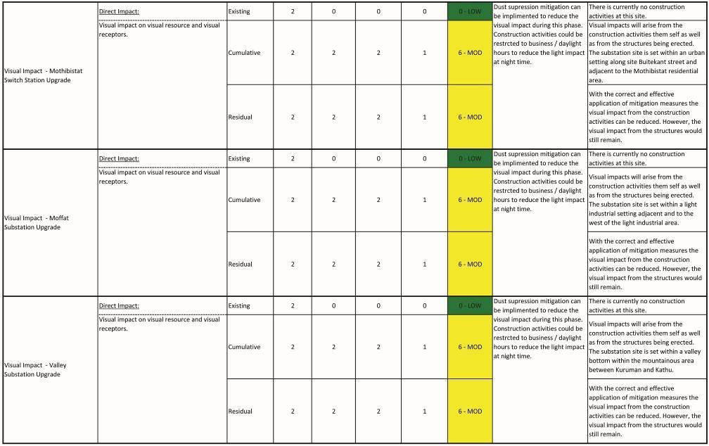
55 Conclusion 9. VISUAL IMPACT ASSESSMENT OF THE PROPOSED SUBSTATION AND SWITCHING STATION UPGRADES The following section will discuss and rate the visual impact of the proposed decommissioning and upgrades of Eldoret, Riries, Moffat, Valley 66kV substations to 132kV substations as well as the decommissioning and upgrade of the Mothibistat and Asbes Switching Stations to a 132kV Substation. For this section the setting of each substation and switch station will be discussed in terms of visibility, visual exposure, visual intrusion as well as the impact on sensitive viewers (refer to section 8 for elaborate discussions on visibility, visual exposure, visual intrusion as well as sensitive viewers) where after the significance of the visual impact will be rated according to the significance table as provided by the environmental consultant. 9.1 Eldoret Substation The Eldoret Substation is located between Hotazel and Kuruman, approximately 3km east of the Magobing community, approximately 1.3km west of an existing mine dump and approximately 1.2km north of a farmstead surrounded only by a good stance of Kalahari Thornveld vegetation. As there is an existing substation, the substation upgrade will have a minimal cumulative negative visual effect. With reference to Table 8.1 below, the pre-construction significance ratings are moderate for the existing, cumulative and residual impacts. In terms of construction, refer to Table 8.2 below, the significance for the existing condition was rated low because there are currently no construction activities. The cumulative and residual impact, were rated moderate, as the construction activities will add nuisance to the existing visual impact. Table 8.3, below, indicates that the significance of the existing, cumulative and residual visual impact would be moderate for the Operational phase. The presence of the 132kV substation will continue to exert a nuisance to the existing visual environment. In terms of Decommissioning, Table 8.4 below, the Decommissioning activities would result in a moderate significance for the visual impact on the existing and cumulative conditions. However, the significance of the residual impact would be low. 9.2 Riries Substation The Riries Substation is located between Hotzael and Kuruman, approximately 110m north of the R31 within a good stance of Kalahari Thornveld. Some small scale historic mining activities are located approximately 150m to the northeast, 600m to the south and 850m to the southwest. As there is an existing substation, the substation upgrade will have a minimal cumulative negative visual effect. With reference to Table 8.1 below, the pre-construction significance ratings are moderate for the existing, cumulative and residual impacts. In terms of Construction, refer to Table 8.2 below, the significance for the existing condition was rated low because there are currently no construction activities. The cumulative and residual impact, were rated moderate, as the construction activities will add nuisance to the existing visual impact. Table 8.3, below, indicates that the significance of the existing, cumulative and residual visual impact would be moderate for the Operational phase. The presence of the 132kV substation will continue to 37
56 Conclusion exert a nuisance to the existing visual environment. In terms of Decommissioning, Table 8.4 below, the Decommissioning activities would result in a moderate significance for the visual impact on the existing and cumulative conditions. However, the significance of the residual impact would be low. 9.3 Mothibistat Substation The Mothibistat Substation is located within Kuruman, approximately 500m south of Buitekant Street adjacent to the Mothibistat residential area. The site is currently occupied by an existing Switching Station. As there is an existing switching station, the substation upgrade will have a minimal cumulative negative visual effect. With reference to Table 8.1 below, the pre-construction significance ratings are moderate for the existing, cumulative and residual impacts. In terms of Construction, refer to Table 8.2 below, the significance for the existing condition was rated low because there are currently no construction activities. The cumulative and residual impact, were rated moderate, as the construction activities will add nuisance to the existing visual impact. Table 8.3, below, indicates that the significance of the existing, cumulative and residual visual impact would be moderate for the Operational phase. The presence of the 132kV substation will continue to exert a nuisance to the existing visual environment. In terms of Decommissioning, Table 8.4 below, the Decommissioning activities would result in a moderate significance for the visual impact on the existing and cumulative conditions. However, the significance of the residual impact would be low. 9.4 Moffat Substation The Moffat Substation is located within Kuruman, adjacent and to the west of the light industrial area in the southern section of Kuruman. As there is an existing substation, the substation upgrade will have a minimal cumulative negative visual effect. With reference to Table 8.1 below, the pre-construction significance ratings are moderate for the existing, cumulative and residual impacts. In terms of Construction, refer to Table 8.2 below, the significance for the existing condition was rated low because there are currently no construction activities. The cumulative and residual impact, were rated moderate, as the construction activities will add nuisance to the existing visual impact. Table 8.3, below, indicates that the significance of the existing, cumulative and residual visual impact would be moderate for the Operational phase. The presence of the 132kV substation will continue to exert a nuisance to the existing visual environment. In terms of Decommissioning, Table 8.4 below, the Decommissioning activities would result in a moderate significance for the visual impact on the existing and cumulative conditions. However, the significance of the residual impact would be low. 9.5 Valley Substation The Valley Substation is located within the mountainous area between Kuruman and Kathu, approximately 19.6km southwest of Kuruman and approximately 29.6km northeast of Kathu. It is situated within a remote valley near a local farm road and approximately 4.1km north of the Mansfield / Holhoek local dirt road. A farmstead is located approximately 1km to the east and some small scale mining activities approximately 38
57 Conclusion 1.5km to the southeast. As there is an existing substation, the substation upgrade will have a minimal cumulative negative visual effect. With reference to Table 8.1 below, the pre-construction significance ratings are moderate for the existing, cumulative and residual impacts. In terms of Construction, refer to Table 8.2 below, the significance for the existing condition was rated low because there are currently no construction activities. The cumulative and residual impact, were rated moderate, as the construction activities will add nuisance to the existing visual impact. Table 8.3, below, indicates that the significance of the existing, cumulative and residual visual impact would be moderate for the Operational phase. The presence of the 132kV substation will continue to exert a nuisance to the existing visual environment. In terms of Decommissioning, Table 8.4 below, the Decommissioning activities would result in a moderate significance for the visual impact on the existing and cumulative conditions. However, the significance of the residual impact would be low. 9.6 Mitigation Measures for the Substation Upgrades Refer to Section 8.5 above. 39

58 Table 8.1: Significance of Visual Impact from the Substations to be Upgraded - Pre-Construction Phase Conclusion 40

59 Table 8.2: Significance of Visual Impact from the Substations to be Upgraded - Construction Phase Conclusion 41
60 Conclusion 42

61 Table 8.3: Significance of Visual Impact from the Substations to be Upgraded - Operational Phase Conclusion 43

62 Conclusion 44

63 Conclusion 45

64 Table 8.4: Significance of Visual Impact from the Substations to be Upgraded - Decommissioning Phase Conclusion 46

65 Conclusion 47
66 10. VISUAL IMPACT ASSESSMENT OF THE PROPOSED POWER LINE ALTERNATIVES Conclusion The following section will discuss and rate the visual impact of the proposed power line upgrade alternatives. The alternatives are as follows: Hotazel Eldoret (alternative 1 and 2) Eldoret - Riries (alternative 1 and 2) Riries - Gamoaan (alternative 1 and 2) Gamohaan - Mothibistat (alternative 1 and 2) Mothibistat - Moffat (alternative 1 and 2) Moffat - Valley (alternative 1 and 2) Valley - Sekgame (4 alternatives) The alternatives will be compared in table format in terms of the following criteria: Distance* along an existing power line (service corridor) Distance* along roads (e.g. road or railway line service corridor) Distance* through virgin land (i.e. not along an existing service corridor) Distance* through or along sensitive landscape types (i.e. mountains and rivers) Presence of residential units (farmsteads / residential areas) within a 500m (foreground) zone * Note: all measured distances are approximate This process will identify a preferred alternative. Because the extent, duration and likelihood of the power line alternatives would be the same potential intensity will be used as the indicating significance factor. The preferred alternative will be allocated with a potential intensity rating of 2 where as the lesser preferred alternative will be allocated with a rating of 4 in the significance tables 10.1 to 10.4 at the end of this discussion Hotazel Eldoret Power Line This power line segment is the northern most section and lies between Hotazel and Kuruman. alternatives are being proposed. Table 9.1: Hotazel Eldoret Power Line Alternatives 1 and 2 Criteria Alternative km Alternative km Two Distance along an existing power line 5.6km 3.4km Distance along roads 0 5.7km Distance through virgin land 10.6km 6.6km Distance through or along sensitive landscape types 0 0 Presence of residential units 1 (300m away) 0 Alternative 2 has a greater distance along service corridors, lesser distance through virgin land and has no residential unit incidence. Alternative 2 is the preferred alternative for this segment. 48
67 10.2 Eldoret Riries Power Line This is the second power line segment from Hotazel and lies between Hotazel and Kuruman. alternatives are being proposed. Table 9.2: Eldoret - Riries Power Line Alternatives 1 and 2 Criteria Alternative km Alternative km Distance along an existing power line km Distance along roads 11.5km 0 Distance through virgin land 7.0km 0 Distance through or along sensitive landscape types 0 0 Presence of residential units 1 (330m away) 1 (370m away) Conclusion Two Alternative 2 runs for its entire length along an existing power line is therefore the preferred alternative for this segment. Refer to Table 10.1 to 10.4 below for the significance ratings Riries Gamohaan Power Line This is the middle power line segment between Hotazel and Kuruman. Two alternatives are being proposed. Table 9.3: Riries - Gamohaan Power Line Alternatives 1 and 2 Criteria Alternative km Alternative km Distance along an existing power line km Distance along roads 18.6km 0 Distance through virgin land 0 9.8km Distance through or along sensitive landscape types 0 6.5km Presence of residential units Maheane community 0 Alternative 1 runs for its entire length along a road and passes on the opposite side of the road along the Maheana community. Alternative 2 runs through the mountainous area and some virgin land for a distance of 9.8km. Alternative 1 is therefore the preferred alternative for this segment. Refer to Table 10.1 to 10.4 below for the significance ratings Gamohaan Mothibistat Power Line This power line segment is the last one between Hotazel and Kuruman. proposed. Two alternatives are being 49
68 Conclusion Table 9.4: Gamohaan Mothibistat Power Line Alternatives 1 and 2 Criteria Alternative 1 Alternative km 13.5km Distance along an existing power line 0 0 Distance along roads 10.2km 8.7km Distance through virgin land 2.7km 3.2km Distance through or along sensitive landscape types river crossing river crossing Presence of residential units passes adjacent to the Kuruman residential area as well as the informal area of Mothibistad passes adjacent to the Kuruman residential area Alternative 2 has a shorter total distance along the roads, longer distance through virgin land and passes adjacent to the residential area of Kuruman. Alternative 1 has a longer distance along the roads and runs adjacent to the residential area of Kuruman. Alternative 1 is therefore the preferred alternative for this segment. Refer to Table 10.1 to 10.4 below for the significance ratings Mothibistat Moffat Power Line This power line segment wraps around Kuruman on its eastern side. Two alternatives are being proposed. Table 9.5: Mothibistat Moffat Power Line Alternatives 1 and 2 Criteria Alternative km Alternative km Distance along an existing power line 10.9km 3.1km Distance along roads 0 0 Distance through virgin land 0 9.9km Distance through or along sensitive landscape types river crossing river crossing Presence of residential units passes adjacent Kuruman residential areas as well as 100m and 200m from guest lodges passes 600m from a golf course Alternative 1 runs along an existing power line for its entire length. Even though it passes 100m and 200m from guest lodges, these are already exposed to the negative visual impact from the existing power line. Alternative 2 runs for 3/4s of its length through virgin land. Alternative 1 is therefore the preferred alternative for this segment. Refer to Table 10.1 to 10.4 below for the significance ratings. 50
69 Conclusion 10.6 Moffat Valley Power Line Moffat Valley is the northern of the two power lines between Kuruman and Kathu. It runs mostly through a mountainous section of the study area. Two alternatives are being proposed. Table 9.6: Moffat Valley Power Line Alternatives 1 and 2 Criteria Alternative km Alternative km Distance along an existing power line 28.0km 5.8km Distance along roads 4.0km 20.1km Distance through virgin land 4.2km 2.3km Distance through or along sensitive landscape types Presence of residential units through approx. 12.2km of mountainous area 8 incidences ranging between 50m and 480m through approx. 16.0km of mountainous area 2 incidences ranging between 220m and 430m Even though Alternative 1 has more incidences with residential units and a greater total distance it is the preferred alternative of the two. Most of the residential units are already exposed to the negative visual impact of the existing power line. Alternative 1 has the greater distance along existing power lines and the lesser distance through sensitive landscapes. Refer to Table 10.1 to 10.4 below for the significance ratings Valley Sekgame Power Line Valley Sekgame is the southern segment of the power line between Kuruman and Kathu. Four alternatives are being proposed. For the purpose of this comparison, the Luhathla Military Area (LMA) boundary fence has been brought in as another criteria falling under service corridors along with roads due to its prominence as a feature in the landscape. Table 9.7: Valley Sekgame Power Line Alternatives 1 to 4 Criteria Alternative km Alternative km Alternative km Alternative km Distance along an existing power line 0 7.0km 0 0 Distance along roads & the LMA boundary fence Total distance along service corridor (12.6km +10.0km) 22.6km (11.7km +0km) 11.7km (0km +17.5km) 17.5km (12.3km +10.0km) 22.3km Distance through virgin land 11.0km 10.7km 11.3km 5.1km Distance through or along sensitive landscape types Presence of residential units through approx. 11.2km of mountainous area 7 incidences ranging between 50m and 480m through approx. 11.0km of mountainous area 10 incidences ranging between 50m and 470m through approx. 12.7km of mountainous area through approx. 11.0km of mountainous area 1 (100m away) 3 incidences ranging from 50m and 170m The distance values had been translated as a percentage of the total distance of the power line where after the alternatives had been scored in each criteria ranging from most preferred (dark green), second most 51
70 Conclusion preferred (light green), second least preferred (yellow) to least preferred (orange). In terms of distance along a power line the greater distance would be the preferred alternative. In terms of distance along roads the LMA boundary fence the greater distance would be preferred. In terms of distance through virgin land the shortest distance would be preferred. In terms of distance through or along sensitive landscapes the shorter distance would be preferred. And lastly, in terms of presence of residential units, the least incidences would be preferred. From Table 9.7 and the discussion above it is clear that Alternative 4 it the preferred alternative as it has two preferred alternative scores as well as two second preferred scores even though it has the third longest total distance. According to the scores on the table, Alternative 2 would be the second preferred alternative as it has the longest distance along an existing power line as well as the shortest distance through or along sensitive landscapes. On the negative side Alternative 2 had the shortest distance along roads or the LMA boundary as well as the highest number of incidences with residential units. Therefore Alternative 1, which has the longest distance along roads and the LMA boundary fence and the second shortest distance through or along sensitive landscapes as well as the second highest number of incidences with residential units, would in actual fact be the second preferred alternative. Even though Alternative 3 had the least number of incidences with residential units, it has scored second worst and worst in all the other criteria. It can thus be concluded that: The preferred alternative is Alternative 4 The second preferred alternative is Alternative 1 The second least alternative is Alternative 2 The least preferred alternative is Alternative 3 For the purpose of significance rating, because the extent, duration and likelihood of the visual impact would be the same for each of the alternatives, the definition would be created in terms of the potential intensity of the visual impact. A Moderate-Low (2) score will be allocated to the preferred alternative, Moderate (4) to the second preferred, Moderate-High (8) to the second least preferred and Moderate-High (12) to the least preferred alternative. Refer to Table 10.1 to 10.4 below for the significance ratings. In summary all ratings were moderate with the exception of the Cumulative and Residual impacts for Alternatives 2 and 3 during Construction phase, Alternatives 1, 2 and 3 during Operational phase as well as Alternatives 2 and 3 Decommissioning phase being high. 52
71 Table 10.1: Significance of Visual Impact from the Power Line Alternatives - Pre-Construction Phase Conclusion Activity Hotazel - Eldoret Alternative 1 Hotazel - Eldoret Alternative 2 Eldoret - Riries Alternative 1 Nature of Impact Impact type Extent PRE-CONSTRUCTION PHASE Duration Potential Intensity Direct Impact: Existing MOD Visual impact on visual resource and visual receptors. Cumulative MOD Residual MOD Direct Impact: Existing MOD Visual impact on visual resource and visual receptors. Cumulative MOD Residual MOD Direct Impact: Existing MOD Visual impact on visual resource and visual receptors. Cumulative MOD Residual MOD 53 Likelihood Rating Mitigation Interpretation No visual impacts from the proposed power line to be mitigated prior to construction. No visual impacts from the proposed power line to be mitigated prior to construction. No visual impacts from the proposed power line to be mitigated prior to construction. The existing power lines have a moderate negative visual impact. No additional visual impact from the proposed power line prior to construction. The residual visual impact therefore remains the same as the existing condition. The existing power lines have a moderate negative visual impact. No additional visual impact from the proposed power line prior to construction. The residual visual impact therefore remains the same as the existing condition. The existing power lines have a moderate negative visual impact. No additional visual impact from the proposed power line prior to construction. The residual visual impact therefore remains the same as the existing condition.
72 Eldoret - Riries Alternative 2 Riries - Gamohaan Alternative 1 Riries - Gamohaan Alternative 2 Gamohaan - Mothibistat Alternative 1 Direct Impact: Existing MOD Visual impact on visual resource and visual receptors. Cumulative MOD Residual MOD Direct Impact: Existing MOD Visual impact on visual resource and visual receptors. Cumulative MOD Residual MOD Direct Impact: Existing MOD Visual impact on visual resource and visual receptors. Cumulative MOD Residual MOD Direct Impact: Existing MOD No visual impacts from the proposed power line to be mitigated prior to construction. No visual impacts from the proposed power line to be mitigated prior to construction. No visual impacts from the proposed power line to be mitigated prior to construction. No visual impacts from the proposed power line to be Conclusion The existing power lines have a moderate negative visual impact. No additional visual impact from the proposed power line prior to construction. The residual visual impact therefore remains the same as the existing condition. The existing power lines have a moderate negative visual impact. No additional visual impact from the proposed power line prior to construction. The residual visual impact therefore remains the same as the existing condition. The existing power lines have a moderate negative visual impact. No additional visual impact from the proposed power line prior to construction. The residual visual impact therefore remains the same as the existing condition. The existing power lines have a moderate negative visual impact. 54
73 Gamohaan - Mothibistat Alternative 2 Mothibistat - Moffat Alternative 1 Mothibistat - Moffat Alternative 2 Visual impact on visual resource and visual receptors. Cumulative MOD Residual MOD Direct Impact: Existing MOD Visual impact on visual resource and visual receptors. Cumulative MOD Residual MOD Direct Impact: Existing MOD Visual impact on visual resource and visual receptors. Cumulative MOD Residual MOD Direct Impact: Existing MOD Visual impact on visual resource and visual receptors. Cumulative MOD mitigated prior to construction. No visual impacts from the proposed power line to be mitigated prior to construction. No visual impacts from the proposed power line to be mitigated prior to construction. No visual impacts from the proposed power line to be mitigated prior to construction. Conclusion No additional visual impact from the proposed power line prior to construction. The residual visual impact therefore remains the same as the existing condition. The existing power lines have a moderate negative visual impact. No additional visual impact from the proposed power line prior to construction. The residual visual impact therefore remains the same as the existing condition. The existing power lines have a moderate negative visual impact. No additional visual impact from the proposed power line prior to construction. The residual visual impact therefore remains the same as the existing condition. The existing power lines have a moderate negative visual impact. No additional visual impact from the proposed power line prior to construction. 55
74 Moffat - Valley Alternative 1 Moffat - Valley Alternative 2 Valley - Sekgame Alternative 1 Residual MOD Direct Impact: Existing MOD Visual impact on visual resource and visual receptors. Cumulative MOD Residual MOD Direct Impact: Existing MOD Visual impact on visual resource and visual receptors. Cumulative MOD Residual MOD Direct Impact: Existing MOD Visual impact on visual resource and visual receptors. Cumulative MOD Residual MOD No visual impacts from the proposed power line to be mitigated prior to construction. No visual impacts from the proposed power line to be mitigated prior to construction. No visual impacts from the proposed power line to be mitigated prior to construction. Conclusion The residual visual impact therefore remains the same as the existing condition. The existing power lines have a moderate negative visual impact. No additional visual impact from the proposed power line prior to construction. The residual visual impact therefore remains the same as the existing condition. The existing power lines have a moderate negative visual impact. No additional visual impact from the proposed power line prior to construction. The residual visual impact therefore remains the same as the existing condition. The existing power lines have a moderate negative visual impact. No additional visual impact from the proposed power line prior to construction. The residual visual impact therefore remains the same as the existing condition. 56
75 Valley - Sekgame Alternative 2 Valley - Sekgame Alternative 3 Valley - Sekgame Alternative 4 Direct Impact: Existing MOD Visual impact on visual resource and visual receptors. Cumulative MOD Residual MOD Direct Impact: Existing MOD Visual impact on visual resource and visual receptors. Cumulative MOD Residual MOD Direct Impact: Existing MOD Visual impact on visual resource and visual receptors. Cumulative MOD Residual MOD No visual impacts from the proposed power line to be mitigated prior to construction. No visual impacts from the proposed power line to be mitigated prior to construction. No visual impacts from the proposed power line to be mitigated prior to construction. Conclusion The existing power lines have a moderate negative visual impact. No additional visual impact from the proposed power line prior to construction. The residual visual impact therefore remains the same as the existing condition. The existing power lines have a moderate negative visual impact. No additional visual impact from the proposed power line prior to construction. The residual visual impact therefore remains the same as the existing condition. The existing power lines have a moderate negative visual impact. No additional visual impact from the proposed power line prior to construction. The residual visual impact therefore remains the same as the existing condition. 57
76 Table 10.2: Significance of Visual Impact from the Power Line Alternatives - Construction Phase Conclusion Activity Nature of Impact Impact type Extent Duration Hotazel - Eldoret Alternative 1 Hotazel - Eldoret Alternative 2 CONSTRUCTION PHASE Potential Intensity Direct Impact: Existing MOD Visual impact on visual resource and visual receptors. Cumulative MOD Residual MOD Direct Impact: Existing MOD Visual impact on visual resource and visual receptors. Cumulative MOD Likelihood Rating Mitigation Interpretation Dust suppression mitigation can be implemented to reduce the visual impact during this phase. Construction activities could be restricted to business / daylight hours to reduce the light impact at night time. Dust suppression mitigation can be implemented to reduce the visual impact during this phase. Construction activities could be restricted to business / daylight hours to reduce the light impact at night time. There is currently no other construction activities along the proposed power line alignment, therefore no visual impact. Visual impacts will arise from the construction activities them self as well as from the structures being erected. The power line runs through 'virgin land' for approximately 2/3rds of its length. With the correct and effective application of mitigation measures the visual impact might be reduced. However, the visual impact from the structures would still remain. There is currently no other construction activities along the proposed power line alignment, therefore no visual impact. Visual impacts will arise from the construction activities them self as well as from the structures being erected. The power line follows service corridors for approximately 2/3rds of its length. 58
77 Eldoret - Riries Alternative 1 Eldoret - Riries Alternative 2 Residual MOD Direct Impact: Existing MOD Visual impact on visual resource and visual receptors. Cumulative MOD Residual MOD Direct Impact: Existing MOD Visual impact on visual resource and visual receptors. Cumulative MOD 59 Dust suppression mitigation can be implemented to reduce the visual impact during this phase. Construction activities could be restricted to business / daylight hours to reduce the light impact at night time. Dust suppression mitigation can be implemented to reduce the visual impact during this phase. Construction activities could be restricted to business / daylight hours to reduce the light impact at night time. Conclusion With the correct and effective application of mitigation measures the visual impact might be reduced. However, the visual impact from the structures would still remain. There is currently no other construction activities along the proposed power line alignment, therefore no visual impact. Visual impacts will arise from the construction activities them self as well as from the structures being erected. The power line runs through 'virgin land' for approximately 1/3rd of its length. With the correct and effective application of mitigation measures the visual impact might be reduced. However, the visual impact from the structures would still remain. There is currently no other construction activities along the proposed power line alignment, therefore no visual impact. Visual impacts will arise from the construction activities them self as well as from the structures being erected. The power line follows an existing power line for its entire length.
78 Riries - Gamohaan Alternative 1 Riries - Gamohaan Alternative 2 Residual MOD Direct Impact: Existing MOD Visual impact on visual resource and visual receptors. Cumulative MOD Residual MOD Direct Impact: Existing MOD Dust suppression mitigation can be implemented to reduce the visual impact during this phase. Construction activities could be restricted to business / daylight hours to reduce the light impact at night time. Dust suppression mitigation can be implemented to reduce the visual impact during this phase. Conclusion With the correct and effective application of mitigation measures the visual impact might be reduced. However, the visual impact from the structures would still remain. There is currently no other construction activities along the proposed power line alignment, therefore no visual impact. Visual impacts will arise from the construction activities them self as well as from the structures being erected. The power line follows a road for its entire length. With the correct and effective application of mitigation measures the visual impact might be reduced. However, the visual impact from the structures would still remain. There is currently no other construction activities along the proposed power line alignment, therefore no visual impact. 60
79 Gamohaan - Mothibistat Alternative 1 Visual impact on visual resource and visual receptors. Cumulative MOD Residual MOD Direct Impact: Existing MOD Visual impact on visual resource and visual receptors. Cumulative MOD Residual MOD Construction activities could be restricted to business / daylight hours to reduce the light impact at night time. Dust suppression mitigation can be implemented to reduce the visual impact during this phase. Construction activities could be restricted to business / daylight hours to reduce the light impact at night time. Conclusion Visual impacts will arise from the construction activities them self as well as from the structures being erected. The power line follows an existing power line for about half its length. However, it runs through 'virgin land' and sensitive landscapes for almost half its length. With the correct and effective application of mitigation measures the visual impact might be reduced. However, the visual impact from the structures would still remain. There is currently no other construction activities along the proposed power line alignment, therefore no visual impact. Visual impacts will arise from the construction activities them self as well as from the structures being erected. The power line follows a road for approximately 3/4s of its length. With the correct and effective application of mitigation measures the visual impact might be reduced. However, the visual impact from the structures would still remain. 61
80 Gamohaan - Mothibistat Alternative 2 Mothibistat - Moffat Alternative 1 Direct Impact: Existing MOD Visual impact on visual resource and visual receptors. Cumulative MOD Residual MOD Direct Impact: Existing MOD Visual impact on visual resource and visual receptors. Cumulative MOD Residual MOD Dust suppression mitigation can be implemented to reduce the visual impact during this phase. Construction activities could be restricted to business / daylight hours to reduce the light impact at night time. Dust suppression mitigation can be implemented to reduce the visual impact during this phase. Construction activities could be restricted to business / daylight hours to reduce the light impact at night time. Conclusion There is currently no other construction activities along the proposed power line alignment, therefore no visual impact. Visual impacts will arise from the construction activities them self as well as from the structures being erected. The power line follows a road for approximately 3/4s of its length. With the correct and effective application of mitigation measures the visual impact might be reduced. However, the visual impact from the structures would still remain. There is currently no other construction activities along the proposed power line alignment, therefore no visual impact. Visual impacts will arise from the construction activities them self as well as from the structures being erected. The power line follows an existing power line for its entire length. With the correct and effective application of mitigation measures the visual impact might be reduced. However, the visual impact from the structures would still remain. 62
81 Mothibistat - Moffat Alternative 2 Moffat - Valley Alternative 1 Direct Impact: Existing MOD Visual impact on visual resource and visual receptors. Cumulative MOD Residual MOD Direct Impact: Existing MOD Visual impact on visual resource and visual receptors. Cumulative MOD Residual MOD Dust suppression mitigation can be implemented to reduce the visual impact during this phase. Construction activities could be restricted to business / daylight hours to reduce the light impact at night time. Dust suppression mitigation can be implemented to reduce the visual impact during this phase. Construction activities could be restricted to business / daylight hours to reduce the light impact at night time. Conclusion There is currently no other construction activities along the proposed power line alignment, therefore no visual impact. Visual impacts will arise from the construction activities them self as well as from the structures being erected. The power line follows an existing power line for 3/4s of its length. With the correct and effective application of mitigation measures the visual impact might be reduced. However, the visual impact from the structures would still remain. There is currently no other construction activities along the proposed power line alignment, therefore no visual impact. Visual impacts will arise from the construction activities them self as well as from the structures being erected. The power line follows an existing power line for 3/4s of its length. With the correct and effective application of mitigation measures the visual impact might be reduced. However, the visual impact from the structures would still remain. 63
82 Moffat - Valley Alternative 2 Valley - Sekgame Alternative 1 Direct Impact: Existing MOD Visual impact on visual resource and visual receptors. Cumulative MOD Residual MOD Direct Impact: Existing MOD Visual impact on visual resource and visual receptors. Cumulative MOD Residual MOD 64 Dust suppression mitigation can be implemented to reduce the visual impact during this phase. Construction activities could be restricted to business / daylight hours to reduce the light impact at night time. Dust suppression mitigation can be implemented to reduce the visual impact during this phase. Construction activities could be restricted to business / daylight hours to reduce the light impact at night time. Conclusion There is currently no other construction activities along the proposed power line alignment, therefore no visual impact. Visual impacts will arise from the construction activities them self as well as from the structures being erected. The power line follows an existing power line for 2/3rds of its length. With the correct and effective application of mitigation measures the visual impact might be reduced. However, the visual impact from the structures would still remain. There is currently no other construction activities along the proposed power line alignment, therefore no visual impact. Visual impacts will arise from the construction activities them self as well as from the structures being erected. Refer to the discussion under Section 10 of the Report. With the correct and effective application of mitigation measures the visual impact might be reduced. However, the visual impact from the structures would still remain.
83 Valley - Sekgame Alternative 2 Valley - Sekgame Alternative 3 Direct Impact: Existing MOD Visual impact on visual resource and visual receptors. Cumulative HIGH Residual HIGH Direct Impact: Existing MOD Visual impact on visual resource and visual receptors. Cumulative HIGH Dust suppression mitigation can be implemented to reduce the visual impact during this phase. Construction activities could be restricted to business / daylight hours to reduce the light impact at night time. Dust suppression mitigation can be implemented to reduce the visual impact during this phase. Construction activities could be restricted to business / daylight hours to reduce the light impact at night time. Conclusion There is currently no other construction activities along the proposed power line alignment, therefore no visual impact. Visual impacts will arise from the construction activities them self as well as from the structures being erected. Refer to the discussion under Section 10 of the Report. With the correct and effective application of mitigation measures the visual impact might be reduced. However, the visual impact from the structures would still remain. There is currently no other construction activities along the proposed power line alignment, therefore no visual impact. Visual impacts will arise from the construction activities them self as well as from the structures being erected. Refer to the discussion under Section 10 of the Report. 65
84 Valley - Sekgame Alternative 4 Residual HIGH Direct Impact: Existing MOD Visual impact on visual resource and visual receptors. Cumulative MOD Residual MOD Dust suppression mitigation can be implemented to reduce the visual impact during this phase. Construction activities could be restricted to business / daylight hours to reduce the light impact at night time. Conclusion With the correct and effective application of mitigation measures the visual impact might be reduced. However, the visual impact from the structures would still remain. There is currently no other construction activities along the proposed power line alignment, therefore no visual impact. Visual impacts will arise from the construction activities them self as well as from the structures being erected. Refer to the discussion under Section 10 of the Report. With the correct and effective application of mitigation measures the visual impact might be reduced. However, the visual impact from the structures would still remain. 66
85 Table 10.3: Significance of Visual Impact from the Power Line Alternatives - Operational Phase Conclusion Activity Hotazel - Eldoret Alternative 1 Hotazel - Eldoret Alternative 2 Eldoret - Riries Alternative 1 Eldoret - Riries Alternative 2 Nature of Impact Impact type Extent OPERATIONAL PHASE Duration Potential Intensity Direct Impact: Existing HIGH Visual impact on visual resource and visual receptors. Cumulative HIGH Residual HIGH Direct Impact: Existing MOD Visual impact on visual resource and visual receptors. Cumulative MOD Residual MOD Direct Impact: Existing HIGH Visual impact on visual resource and visual receptors. Cumulative HIGH Residual HIGH Direct Impact: Existing MOD Visual impact on visual resource and visual receptors. Cumulative MOD Residual MOD Likelihood Rating Mitigation Interpretation Visual impacts will arise from the presence of the power line towers. The power line runs through 'virgin land' for approximately 2/3rds of its length. Visual impacts will arise from the presence of the power line towers. The power line follows service corridors for approximately 2/3rds of its length. Visual impacts will arise from the presence of the power line towers. The power line runs through 'virgin land' for approximately 1/3rd of its length. Visual impacts will arise from the presence of the power line towers. The power line follows an existing power line for its entire length. 67
86 Riries - Gamohaan Alternative 1 Riries - Gamohaan Alternative 2 Gamohaan - Mothibistat Alternative 1 Gamohaan - Mothibistat Alternative 2 Direct Impact: Existing MOD Visual impact on visual resource and visual receptors. Cumulative MOD Residual MOD Direct Impact: Existing HIGH Visual impact on visual resource and visual receptors. Cumulative HIGH Residual HIGH Direct Impact: Existing MOD Visual impact on visual resource and visual receptors. Cumulative MOD Residual MOD Direct Impact: Existing HIGH Visual impact on visual resource and visual receptors. Cumulative HIGH Residual HIGH Mothibistat - Moffat Direct Impact: Existing MOD Conclusion Visual impacts will arise from the presence of the power line towers. The power line follows a road for its entire length. Visual impacts will arise from the presence of the power line towers. The power line follows an existing power line for about half its length. However, it runs through 'virgin land' and sensitive landscapes for almost half its length. Visual impacts will arise from the presence of the power line towers. The power line follows a road for approximately 3/4s of its length. Visual impacts will arise from the presence of the power line towers. The power line follows a road for approximately 3/4s of its length. 68
87 Alternative 1 Mothibistat - Moffat Alternative 2 Moffat - Valley Alternative 1 Moffat - Valley Alternative 2 Valley - Sekgame Alternative 1 Visual impact on visual resource and visual receptors. Cumulative MOD Residual MOD Direct Impact: Existing HIGH Visual impact on visual resource and visual receptors. Cumulative HIGH Residual HIGH Direct Impact: Existing MOD Visual impact on visual resource and visual receptors. Cumulative MOD Residual MOD Direct Impact: Existing MOD Visual impact on visual resource and visual receptors. Cumulative HIGH Residual HIGH Direct Impact: Existing MOD Visual impact on visual resource and visual receptors. Cumulative HIGH Residual HIGH Valley - Sekgame Direct Impact: Existing MOD Conclusion Visual impacts will arise from the presence of the power line towers. The power line follows an existing power line for its entire length. Visual impacts will arise from the presence of the power line towers. The power line follows an existing power line for 3/4s of its length. Visual impacts will arise from the presence of the power line towers. The power line follows an existing power line for 3/4s of its length. Visual impacts will arise from the presence of the power line towers. The power line follows an existing power line for 2/3rds of its length. Visual impacts will arise from the presence of the power line towers. Refer to the discussion under Section 10 of the Visual Impact Assessment Report. 69
88 Alternative 2 Valley - Sekgame Alternative 3 Valley - Sekgame Alternative 4 Visual impact on visual resource and visual receptors. Cumulative HIGH Residual HIGH Direct Impact: Existing MOD Visual impact on visual resource and visual receptors. Cumulative HIGH Residual HIGH Direct Impact: Existing MOD Visual impact on visual resource and visual receptors. Cumulative MOD Residual MOD Conclusion Visual impacts will arise from the presence of the power line towers. Refer to the discussion under Section 10 of the Visual Impact Assessment Report. Visual impacts will arise from the presence of the power line towers. Refer to the discussion under Section 10 of the Visual Impact Assessment Report. Visual impacts will arise from the presence of the power line towers. Refer to the discussion under Section 10 of the Visual Impact Assessment Report. 70
89 Table 10.4: Significance of Visual Impact from the Power Line Alternatives - Decommissioning Phase Conclusion Activity Hotazel - Eldoret Alternative 1 Nature of Impact Impact type Extent DECOMMISSIONING PHASE Duration Potential Intensity Direct Impact: Existing MOD Visual impact on visual resource and visual receptors. Cumulative MOD Residual MOD Likelihood Rating Mitigation Interpretation Dust suppression mitigation can be implemented to reduce the visual impact during this phase. Decommissioning activities could be restricted to business / daylight hours to reduce the light impact at night time. The disturbed landscape should be rehabilitated and vegetated with indigenous plants once decommissioning has been completed. Visual impacts would arise from the decommissioning activities. Visual impacts would arise from the decommissioning activities. After decommissioning and rehabilitation of the power line footprints, the area could be restored to its initial land use status. Hotazel - Eldoret Alternative 2 Direct Impact: Existing MOD Visual impact on visual resource and visual receptors. Cumulative MOD Dust suppression mitigation can be implemented to reduce the visual impact during this phase. Decommissioning activities could be Visual impacts would arise from the decommissioning activities. Visual impacts would arise from the decommissioning activities. 71
90 Eldoret - Riries Alternative 1 Eldoret - Riries Alternative 2 Residual MOD Direct Impact: Existing MOD Visual impact on visual resource and visual receptors. Cumulative MOD Residual MOD Direct Impact: Existing MOD Visual impact on visual resource and visual receptors. Cumulative MOD 72 restricted to business / daylight hours to reduce the light impact at night time. The disturbed landscape should be rehabilitated and vegetated with indigenous plants once decommissioning has been completed. Dust suppression mitigation can be implemented to reduce the visual impact during this phase. Decommissioning activities could be restricted to business / daylight hours to reduce the light impact at night time. The disturbed landscape should be rehabilitated and vegetated with indigenous plants once decommissioning has been completed. Dust suppression mitigation can be implemented to reduce the visual impact during this phase. Decommissioning Conclusion After decommissioning and rehabilitation of the power line footprints, the area could be restored to its initial land use status. Visual impacts would arise from the decommissioning activities. Visual impacts would arise from the decommissioning activities. After decommissioning and rehabilitation of the power line footprints, the area could be restored to its initial land use status. Visual impacts would arise from the decommissioning activities. Visual impacts would arise from the decommissioning
91 Residual MOD activities could be restricted to business / daylight hours to reduce the light impact at night time. The disturbed landscape should be rehabilitated and vegetated with indigenous plants once decommissioning has been completed. Conclusion activities. After decommissioning and rehabilitation of the power line footprints, the area could be restored to its initial land use status. Riries - Gamohaan Alternative 1 Direct Impact: Existing MOD Visual impact on visual resource and visual receptors. Cumulative MOD Residual MOD Dust suppression mitigation can be implemented to reduce the visual impact during this phase. Decommissioning activities could be restricted to business / daylight hours to reduce the light impact at night time. The disturbed landscape should be rehabilitated and vegetated with indigenous plants once decommissioning has been completed. Visual impacts would arise from the decommissioning activities. Visual impacts would arise from the decommissioning activities. After decommissioning and rehabilitation of the power line footprints, the area could be restored to its initial land use status. Riries - Gamohaan Alternative 2 Direct Impact: Existing MOD 73 Dust suppression mitigation can be implemented to reduce the visual Visual impacts would arise from the decommissioning activities.
92 Visual impact on visual resource and visual receptors. Cumulative MOD Residual MOD impact during this phase. Decommissioning activities could be restricted to business / daylight hours to reduce the light impact at night time. The disturbed landscape should be rehabilitated and vegetated with indigenous plants once decommissioning has been completed. Conclusion Visual impacts would arise from the decommissioning activities. After decommissioning and rehabilitation of the power line footprints, the area could be restored to its initial land use status. Gamohaan - Mothibistat Alternative 1 Direct Impact: Existing MOD Visual impact on visual resource and visual receptors. Cumulative MOD Residual MOD Dust suppression mitigation can be implemented to reduce the visual impact during this phase. Decommissioning activities could be restricted to business / daylight hours to reduce the light impact at night time. The disturbed landscape should be rehabilitated and vegetated with indigenous plants once decommissioning has been completed. Visual impacts would arise from the decommissioning activities. Visual impacts would arise from the decommissioning activities. After decommissioning and rehabilitation of the power line footprints, the area could be restored to its initial land use status. Gamohaan - Mothibistat Direct Impact: Existing MOD 74 Dust suppression mitigation can be Visual impacts would arise from the
93 Alternative 2 Visual impact on visual resource and visual receptors. Cumulative MOD Residual MOD implemented to reduce the visual impact during this phase. Decommissioning activities could be restricted to business / daylight hours to reduce the light impact at night time. The disturbed landscape should be rehabilitated and vegetated with indigenous plants once decommissioning has been completed. Conclusion decommissioning activities. Visual impacts would arise from the decommissioning activities. After decommissioning and rehabilitation of the power line footprints, the area could be restored to its initial land use status. Mothibistat - Moffat Alternative 1 Direct Impact: Existing MOD Visual impact on visual resource and visual receptors. Cumulative MOD Residual MOD Dust suppression mitigation can be implemented to reduce the visual impact during this phase. Decommissioning activities could be restricted to business / daylight hours to reduce the light impact at night time. The disturbed landscape should be rehabilitated and vegetated with indigenous plants once decommissioning has been completed. Visual impacts would arise from the decommissioning activities. Visual impacts would arise from the decommissioning activities. After decommissioning and rehabilitation of the power line footprints, the area could be restored to its initial land use status. 75
94 Mothibistat - Moffat Alternative 2 Direct Impact: Existing MOD Visual impact on visual resource and visual receptors. Cumulative MOD Residual MOD Dust suppression mitigation can be implemented to reduce the visual impact during this phase. Decommissioning activities could be restricted to business / daylight hours to reduce the light impact at night time. The disturbed landscape should be rehabilitated and vegetated with indigenous plants once decommissioning has been completed. Conclusion Visual impacts would arise from the decommissioning activities. Visual impacts would arise from the decommissioning activities. After decommissioning and rehabilitation of the power line footprints, the area could be restored to its initial land use status. Moffat - Valley Alternative 1 Direct Impact: Existing MOD Visual impact on visual resource and visual receptors. Cumulative MOD Dust suppression mitigation can be implemented to reduce the visual impact during this phase. Decommissioning activities could be Visual impacts would arise from the decommissioning activities. Visual impacts would arise from the decommissioning activities. 76
95 Residual MOD restricted to business / daylight hours to reduce the light impact at night time. The disturbed landscape should be rehabilitated and vegetated with indigenous plants once decommissioning has been completed. Conclusion After decommissioning and rehabilitation of the power line footprints, the area could be restored to its initial land use status. Moffat - Valley Alternative 2 Direct Impact: Existing MOD Visual impact on visual resource and visual receptors. Cumulative MOD Residual MOD Dust suppression mitigation can be implemented to reduce the visual impact during this phase. Decommissioning activities could be restricted to business / daylight hours to reduce the light impact at night time. The disturbed landscape should be rehabilitated and vegetated with indigenous plants once decommissioning has been completed. Visual impacts would arise from the decommissioning activities. Visual impacts would arise from the decommissioning activities. After decommissioning and rehabilitation of the power line footprints, the area could be restored to its initial land use status. Valley - Sekgame Alternative 1 Direct Impact: Existing MOD Visual impact on visual resource and visual Cumulative MOD 77 Dust suppression mitigation can be implemented to reduce the visual impact during this phase. Visual impacts would arise from the decommissioning activities. Visual impacts would arise from the
96 Valley - Sekgame Alternative 2 Valley - Sekgame Alternative 3 receptors. Residual MOD Direct Impact: Existing MOD Visual impact on visual resource and visual receptors. Cumulative HIGH Residual HIGH Direct Impact: Existing MOD Decommissioning activities could be restricted to business / daylight hours to reduce the light impact at night time. The disturbed landscape should be rehabilitated and vegetated with indigenous plants once decommissioning has been completed. Dust suppression mitigation can be implemented to reduce the visual impact during this phase. Decommissioning activities could be restricted to business / daylight hours to reduce the light impact at night time. The disturbed landscape should be rehabilitated and vegetated with indigenous plants once decommissioning has been completed. Dust suppression mitigation can be implemented to reduce the visual Conclusion decommissioning activities. After decommissioning and rehabilitation of the power line footprints, the area could be restored to its initial land use status. Visual impacts would arise from the decommissioning activities. Visual impacts would arise from the decommissioning activities. After decommissioning and rehabilitation of the power line footprints, the area could be restored to its initial land use status. Visual impacts would arise from the decommissioning activities. 78
97 Valley - Sekgame Alternative 4 Visual impact on visual resource and visual receptors. Cumulative HIGH Residual HIGH Direct Impact: Existing MOD Visual impact on visual resource and visual receptors. Cumulative MOD Residual MOD impact during this phase. Decommissioning activities could be restricted to business / daylight hours to reduce the light impact at night time. The disturbed landscape should be rehabilitated and vegetated with indigenous plants once decommissioning has been completed. Dust suppression mitigation can be implemented to reduce the visual impact during this phase. Decommissioning activities could be restricted to business / daylight hours to reduce the light impact at night time. The disturbed landscape should be rehabilitated and vegetated with indigenous plants once decommissioning has been completed. Conclusion Visual impacts would arise from the decommissioning activities. After decommissioning and rehabilitation of the power line footprints, the area could be restored to its initial land use status. Visual impacts would arise from the decommissioning activities. Visual impacts would arise from the decommissioning activities. After decommissioning and rehabilitation of the power line footprints, the area could be restored to its initial land use status. 79
98 Conclusion 10.8 Mitigation Measures for the Substation Upgrades Refer to Section 8.5 above. Mitigation measures would be mostly applicable to the Construction and Decommissioning phases. Very little can be done to screen a linear impact of this scale. The most effective would be to implement a visual screen, e.g. a vegetation buffer, at the sensitive visual receptor location. 80
99 11. CONCLUSION Conclusion From the above visual analysis and comparative study the following conclusions can be made with regards the two new substations, Gamohaan and Sekgame: The significance of the two new substations was rated as low for the Pre-construction phase. For the Construction phase, the existing condition were rated as low while the cumulative and residual condition was rated as high for the Gamoane Substation and moderate for the Sekgame Substation. This was similar for the Operational Phase. In terms of the Decommissioning phase, the existing condition and cumulative impact were rated as moderate and residual impact as low. This is due to the Gamoane Substation being located within a service corridor at the foot of a mountain and near a river its severity had been rated as moderate. While the Sekgame Substation is located within a service corridor near mine dumps, its severity has therefore been rated as low. In terms of the substations and switch station upgrades the following can be concluded: Eldoret Substation: The pre-construction significance ratings are moderate for the existing, cumulative and residual impacts. In terms of Construction the significance for the existing condition was rated low because there are currently no construction activities. The cumulative and residual impact, were rated moderate, as the construction activities will add nuisance to the existing visual impact. The significance of the existing, cumulative and residual visual impact would be moderate for the Operational phase. The presence of the 132kV substation will continue to exert a nuisance to the existing visual environment. Decommissioning activities would result in a moderate significance for the visual impact on the existing and cumulative conditions. However, the significance of the residual impact would be low. Riries Substation: The pre-construction significance ratings are moderate for the existing, cumulative and residual impacts. In terms of Construction, the significance for the existing condition was rated low because there are currently no construction activities. The cumulative and residual impact, were rated moderate, as the construction activities will add nuisance to the existing visual impact. The significance of the existing, cumulative and residual visual impact would be moderate for the Operational phase. The presence of the 132kV substation will continue to exert a nuisance to the existing visual environment. Decommissioning activities would result in a moderate significance for the visual impact on the existing and cumulative conditions. However, the significance of the residual impact would be low. Mothibistat Substation: The pre-construction significance ratings are moderate for the existing, cumulative and residual impacts. In terms of Construction, the significance for the existing condition was rated low because there are currently no construction activities. The cumulative and residual impact, were rated moderate, as the construction activities will add nuisance to the existing visual impact. The significance of the existing, cumulative and residual visual impact would be moderate for the Operational phase. The presence of the 132kV substation will continue to exert a nuisance to the existing visual environment. Decommissioning activities would result in a moderate significance for the visual impact on 81
100 Conclusion the existing and cumulative conditions. However, the significance of the residual impact would be low. Moffat Substation: The pre-construction significance ratings are moderate for the existing, cumulative and residual impacts. In terms of Construction, the significance for the existing condition was rated low because there are currently no construction activities. The cumulative and residual impact, were rated moderate, as the construction activities will add nuisance to the existing visual impact. The significance of the existing, cumulative and residual visual impact would be moderate for the Operational phase. The presence of the 132kV substation will continue to exert a nuisance to the existing visual environment. Decommissioning activities would result in a moderate significance for the visual impact on the existing and cumulative conditions. However, the significance of the residual impact would be low. Valley Substation: The pre-construction significance ratings are moderate for the existing, cumulative and residual impacts. In terms of Construction, the significance for the existing condition was rated low because there are currently no construction activities. The cumulative and residual impact, were rated moderate, as the construction activities will add nuisance to the existing visual impact. The significance of the existing, cumulative and residual visual impact would be moderate for the Operational phase. The presence of the 132kV substation will continue to exert a nuisance to the existing visual environment. Decommissioning activities would result in a moderate significance for the visual impact on the existing and cumulative conditions. However, the significance of the residual impact would be low. The findings of the comparative visual analysis for the upgrade of the power line between Hotzael, Kuruman and Kathu can be concluded as follows: Hotazel Eldoret: Alternative 2 is the preferred alternative for this segment as it has a greater distance along service corridors, lesser distance through virgin land and has no residential unit incidence. Eldoret Riries: Alternative 2 runs for its entire length along an existing power line is therefore the preferred alternative for this segment. Riries Gamohaan: Alternative 1 is the preferred alternative for this segment as it runs for its entire length along a road and passes on the opposite side of the road along the Maheana community. Gamohaan Mothibistat: Alternative 1 is the preferred alternative for this segment as it has a shorter total distance, shorter distance through virgin land and passes adjacent the residential area of Kuruman. Mothibistat Moffat: Alternative 1 is the preferred alternative for this segment as it runs along an existing power line for its entire length. Even though it passes 100m and 200m from guest lodges, these are already exposed to the negative visual impact from the existing power line. Moffat Valley: Even though Alternative 1 has more incidences with residential units and a greater total distance it is the preferred alternative of the two. Most of the residential units 82
101 Conclusion are already exposed to the negative visual impact of the existing power line. Alternative 1 has the greater distance along existing power lines and the lesser distance through virgin lands and sensitive landscapes. Valley Sekgame: This segment has four alternatives. The preferred alternative is Alternative 4. The second preferred alternative is Alternative 1. Alternative 2 is the second least and Alternative 3 the least preferred alternative. Alternative 4 it the preferred alternative even though it has the third longest total distance of the four alternatives. It was the preferred alternative in two sets of the criteria as well as the second preferred in another two sets of criteria. The first photo simulation below portrays what the proposed new Sekgame substation with power line alternative 2 could look like. Photo simulation 2 portrays what power line alternative 1 between Moffat and Valley substations could look like. 83

102 Conclusion 84
Visual Impact Assessment for the Proposed Solar Photovoltaic installation at the Grootvlei Power Station, Mpumalanga Province
 Professional Opinion: Visual Impact Assessment Final Report Visual Impact Assessment for the Proposed Solar Photovoltaic installation at the Grootvlei Power Station, Mpumalanga Province Yonanda Martin
Medupi Flue Gas Desulphurisation and ADF changes, Lephalele, Limpopo Province
 Visual Impact Assessment Report Medupi Flue Gas Desulphurisation and ADF changes, Lephalele, Limpopo Province Yonanda Martin Newtown Landscape Architects PROPOSED MEDUPI FLUE GAS DESULPHURISATION (FGD)
Annex G.11. Visual Specialist Report
 Annex G.11 Visual Specialist Report Proposed Gamsberg Zinc Mine & Associated Infrastructure near Aggenys, Northern Cape ACRONYMS, ABBREVIATIONS & GLOSSARY Acronyms & Abbreviations CSIR EIA IFC SACLAP VIA
Annex 5F. Visual Impact Assessment Report compiled by Newtown Landscape Architects cc, March 2015
 Annex 5F Visual Impact Assessment Report compiled by Newtown Landscape Architects cc, March 2015 Visual Impact Assessment Report Version 1.0 Final Report March 2015 Document Ref. Prepared By Reviewed
Visual Impact Assessment Addendum B FINAL. Proposed ACWA Power SolarReserve Redstone Solar Thermal Energy Plant Photovoltaic Power Plant
 Visual Impact Assessment Addendum B FINAL Proposed ACWA Power SolarReserve Redstone Solar Thermal Energy Plant Photovoltaic Power Plant Graham A Young (PrLArch) Newtown Landscape Architects Redstone CSP
Visual Impact Assessment - December Figure 5.2: Viewshed analysis of the haul route.
 Visual Assessment - December 2014 Figure 5.2: Viewshed analysis of the haul route. 21 Baobab Resources (Pty) Ltd 5.1.3 Visual Exposure The following can be deduced from the Figure 5.1: the area to the
7. The Landscape. 7.1 Introduction. Environmental Impact Statement (EIS) Scoping Report
 Scoping Report") 7. The Landscape 7.1 Introduction The purpose of this section of the EIS Scoping Report is to describe the scope of work and methods to be applied in the identification and assessment of landscape and
7. The Landscape 7.1 Introduction The purpose of this section of the EIS Scoping Report is to describe the scope of work and methods to be applied in the identification and assessment of landscape and
Digital Terrestrial Television Infrastructure Rollout. Environmental Impact Assessment - Corridor -
 Digital Terrestrial Television Infrastructure Rollout Environmental Impact Assessment - Corridor - 1 1 ENVIRONMENTAL IMPACT ASSESSMENT (EIA): CORRIDOR 1.1 INTRODUCTION Corridor is a small farming community
Genex Kidston Connection Project: Draf t Environmental Assessment Report Powerlink Queensland
 : Draf t Environmental Assessment Report Powerlink Queensland Chapter 14 \\autsv1fp001\projects\605x\60577456\6. Draft Docs\6.1 Reports\4. Compiled draft 17 September\Covers\Chapters\Ch 14.docx Rev ision
Digital Terrestrial Television Infrastructure Rollout. Site-specific Environmental Management Plan - Omega -
 Digital Terrestrial Television Infrastructure Rollout Site-specific Environmental Management Plan - Omega - 2 1 ENVIRONMENTAL IMPACT ASSESSMENT: OMEGA 1.1 RATIONALE FOR THE SITE Omega is situated in the
Digital Terrestrial Television Infrastructure Rollout. Environmental Impact Assessment - Tsumkwe -
 Digital Terrestrial Television Infrastructure Rollout Environmental Impact Assessment - Tsumkwe - 1 1 ENVIRONMENTAL IMPACT ASSESSMENT: TSUMKWE 1.1 RATIONALE FOR THE SITE Tsumkwe is a small town located
Figure 6e: Ndwalane Mainline Toll Plaza Viewshed Analysis
 Figure 6e: Ndwalane Mainline Toll Plaza Viewshed Analysis CAVE KLAPWIJK AND ASSOCIATES 27 Figure 6f: Alternative Ndwalane Mainline Toll Plaza Viewshed Analysis CAVE KLAPWIJK AND ASSOCIATES 28 Figure 6g:
VISUAL IMPACT ASSESSMENT
 ENVIRONMENTAL IMPACT ASSESSMENT FOR THE PROPOSED 170KM 1X400KV MAPHUTHA-WITKOP POWERLINE, LIMPOPO PROVINCE VISUAL IMPACT ASSESSMENT PREPARED FOR: NSOVO ENVIRONMENTAL CONSULTING CONTACT: REJOICE APHANE
Visual Impact Assessment January 2013
 Measures Maintain as much natural vegetation as possible between the mine buildings and the perimeter of the mine. The layout for mine buildings should include vegetation such as trees and thicket to break
Digital Terrestrial Television Infrastructure Rollout
 Digital Terrestrial Television Infrastructure Rollout Environmental Impact Assessment - Ruacana - ENVIRONMENTAL IMPACT ASSESSMENT: RUACANA 1 INTRODUCTION Ruacana is a town in the Omusati Region, in northern
Proposed Shell Filling Station Parklands, Western Cape. Visual Impact Assessment
 Proposed Shell Filling Station Parklands, Western Cape Visual Impact Assessment Draft March 201 Prepared Bernard Oberholzer Landscape Architect and Environmental Planner In association with Quinton Lawson,
Visual Impact Rating Form - Instructions
 Visual Impact Rating Form Instructions Project Name: Baron Winds Project EDR Project No: 13039 Date: 05.16.17 Reference: Visual Impact Rating Form - Instructions These instructions are intended to guide
Vissershok North Waste Management Licence EIA Process
 FINAL Visual Study Update Vissershok North Waste Management Licence EIA Process Graham A. Young PrLArch Newtown Landscape Architects VISUAL STUDY UPDATE for the VISSERSHOK NORTH WASTE MANAGEMENT LICENCE
TOWN OF AURORA HERITAGE IMPACT ASSESSMENTS AND CONSERVATION PLANS GUIDE
 PLANNING AND DEVELOPMENT SERVICES Development Planning Division Heritage Planning Section Phone: 905-727-3123 ext. 4226 Fax: 905-726-4736 Email: planning@aurora.ca Town of Aurora 100 John West Way, Box
Chapter 7: Landscape and Visual Impact Assessment
 Chapter 7: Landscape and Visual Impact Assessment Landscape Character and Visual Impact Assessment 7. Landscape Character and Visual Impact Assessment... 2 7.1 Methodology... 2 7.2 Assessment Findings...
ESKOM PROPOSED CONSTRUCTION OF A 88KV POWER LINE BETWEEN CLOCOLAN AND FICKSBURG VISUAL IMPACT ASSESSMENT DRAFT REPORT
 ESKOM PROPOSED CONSTRUCTION OF A 88KV POWER LINE BETWEEN CLOCOLAN AND FICKSBURG VISUAL IMPACT ASSESSMENT DRAFT REPORT April 2013 PREPARED BY PO BOX 2122, WESTVILLE, 3630, SOUTH AFRICA FOR ACER Environmental
Section 6A 6A Purpose of the Natural Features and Landscapes Provisions
 Section 6A 6A Purpose of the Natural Features and Landscapes Provisions This Chapter addresses the protection and management of natural features and landscapes within the City. The City has a number of
Visual Resource. July 2017
 Visual Resource 35 Visual Receptors 9. VISUAL RECEPTORS 9.1 Views Typically visual receptors within the study area are people travelling along local roads, residents staying in the farmsteads or workers
APPENDIX 7.1: LANDSCAPE AND VISUAL IMPACT ASSESSMENT METHODOLOGY
 APPENDIX 7.1: LANDSCAPE AND VISUAL IMPACT ASSESSMENT METHODOLOGY 1.0 Introduction 1.1 Landscape and Visual Impact Assessment (LVIA) is a tool used to systematically identify and assess the nature and significance
SITE INVESTIGATION REPORT: CONSTRUCTION OF NTUMBA VEHICULAR/PEDESTRIAN BRIDGE ACROSS A STREAM IN ROOKDALE, OKHAHLAMBA LOCAL MUNICIPALITY
 SITE INVESTIGATION REPORT: CONSTRUCTION OF NTUMBA VEHICULAR/PEDESTRIAN BRIDGE ACROSS A STREAM IN ROOKDALE, OKHAHLAMBA LOCAL MUNICIPALITY PREPARED ON BEHALF OF: ECA CONSULTING CIVIL & STRUCTURAL ENGINEERS
Salhouse Parish Council, 11 th November Response to Planning Application
 Salhouse Parish Council, 11 th November 2013 Response to Planning Application 20131408 Summary Salhouse Parish Council (SPC) has received via Broadland District Council a Planning Application for a 5MWp
Section 3b: Objectives and Policies Rural Environment Updated 19 November 2010
 Page 1 of Section 3b 3b RURAL ENVIRONMENT 3b.1 Introduction The Rural Environment comprises all the land outside of the Residential, Town Centre and Industrial Environments. Most land within the District
RURAL ZONE - POLICY. Rural Zone Policy. Issue: Rural Environment. Ruapehu District Plan Page 1 of 8
 Rural Zone Policy RU2 RURAL ZONE - POLICY RU2.1 Introduction The natural resources of the rural environment in the Ruapehu District provide the basis for the existing and potential character, intensity
Cape Environmental Assessment Practitioners(Pty)
") BACKGROUND INFORMATION DOCUMENT (BID) Introduction Cape Environmental Assessment Practitioners(Pty) Ltd Reg. No. 2008/004627/07 Telephone: (044) 874 0365 First Floor, Eagles View Building Facsimile: (044)
BACKGROUND INFORMATION DOCUMENT (BID) Introduction Cape Environmental Assessment Practitioners(Pty) Ltd Reg. No. 2008/004627/07 Telephone: (044) 874 0365 First Floor, Eagles View Building Facsimile: (044)
3. Highway Landscaping Assessment
 Guidelines for Highway Landscaping 3-1 3. Highway Landscaping Assessment 3.1 Introduction This section outlines the steps necessary to assess the highway landscaping component of a state highway construction
Digital Terrestrial Television Infrastructure Rollout. Environmental Impact Assessment - Kongola -
 Digital Terrestrial Television Infrastructure Rollout Environmental Impact Assessment - Kongola - 1 1 ENVIRONMENTAL IMPACT ASSESSMENT: KONGOLA 1.1 RATIONALE FOR THE SITE Kongola is situated in the Caprivi
Definition of Cumulative Landscape and Visual Effects
 SECTION 5: GUIDANCE FOR ASSESSING CUMULATIVE LANDSCAPE AND VISUAL EFFECTS 5.1 Although this landscape sensitivity and capacity study has identified that parts of the National Park may be able to accommodate
Lower Sensitivity. VS Classification Level 2: Hills, Lower Plateau & Scarp Slopes (74%)/ Lowland Valleys (17%) / Exposed Upland/Plateau (7%)
/ Lowland Valleys (17%) / Exposed Upland/Plateau (7%)") S06 Coedwig Gwydyr Reproduced from the Ordnance Survey map with the permission of Ordnance Survey on behalf of the Controller of Her Majesty s Stationery Office, Crown copyright Licence No. 100023387 Location
S06 Coedwig Gwydyr Reproduced from the Ordnance Survey map with the permission of Ordnance Survey on behalf of the Controller of Her Majesty s Stationery Office, Crown copyright Licence No. 100023387 Location
Mining as a scar on the landscape
 Mine Closure 2012 A.B. Fourie and M. Tibbett (eds) 2012 Australian Centre for Geomechanics, Perth, ISBN 978-0-9870937-0-7 https://papers.acg.uwa.edu.au/p/1208_21_burge/ H. Burge Environmental Resources
Garden Bridge Planning Application
 Planning Application Additional Verified photomontages and assessment September 2014 Contents Page 1 Visual assessment 2 1.1 Introduction 2 1.2 Baseline 2 1.3 Potential effects and good environmental
SINGITA SWENI LODGE EXPANSION: SUMMARY REPORT - BAR
 7 PROJECT: SINGITA SWENI LODGE EXPANSION: SUMMARY REPORT - BAR Basic Environmental Assessment for Lodge expansion and Refurbishment of the Singita Sweni Lodge, within the Singita Private Concession in
PURPOSE OF MEETING MEETING GUIDELINES PROJECT BACKGROUND ESKOM CLOCOLAN-FICKSBURG 88 KV POWERLINE, FREE STATE
 ESKOM CLOCOLAN-FICKSBURG 88 KV POWERLINE, FREE STATE DRAFT BASIC ASSESSMENT REPORT PUBLIC REVIEW LANDOWNERS MEETING FICKSBURG 23 JULY 2013 T his project is being conducted on behalf of Eskom PRESENTATION
Annex H. Visual Specialist Report
 Annex H Visual Specialist Report ENVIRONMENTAL RESOURCES MANAGEMENT I1 DRAFT VISUAL IMPACT ASSESSMENT PROPOSED DRENNAN PV SOLAR PARK, EASTERN CAPE PROVINCE June 2013 Prepared for: ERM Cape Town 2 nd Floor,
3.1 This evidence is based on the landscape and visual impact assessment included in Chapter 10 and Appendix I of the EIS.
 LANDSCAPE & VISUAL 1 QUALIFICATIONS AND EXPERIENCE 1.1 My name is Raymond Holbeach and I am a Regional Director for RPS Planning & Environment with full responsibility for management of the RPS Belfast
PHASE 1 ARCHAEOLOGICAL IMPACT ASSESSMENT PROPOSED DEVELOPMENT ERF 3 ROBERTSON WESTERN CAPE PROVINCE
 PHASE 1 ARCHAEOLOGICAL IMPACT ASSESSMENT PROPOSED DEVELOPMENT ERF 3 ROBERTSON WESTERN CAPE PROVINCE Prepared for BOLAND ENVIRO Att: Mr Nik Wullschleger PO Box 250 Worcester 6849 Fax: (023) 347 0336 By
SUSTAINABLE MANAGEMENT
 . Sustainable Management.1 The Concept of Sustainable Management The concept of sustainable management recognises there are limits to the use of natural and physical resources and there is a need to balance
Tables of Criteria and Matrices for Landscape Assessment (LSCA & LVIA)
") Carly Tinkler CMLI Environmental, Landscape and Colour Consultancy 46 Jamaica Road, Malvern, Worcestershire WR14 1TU Tel +44 (0)7711 538854 carlytinkler@hotmail.co.uk Tables of Criteria and Matrices for
Carly Tinkler CMLI Environmental, Landscape and Colour Consultancy 46 Jamaica Road, Malvern, Worcestershire WR14 1TU Tel +44 (0)7711 538854 carlytinkler@hotmail.co.uk Tables of Criteria and Matrices for
Nob Hill Pipeline Improvements Project EIR
 Section 3.1 Aesthetics This section addresses the visual aspects that may affect the views experienced by the public, including the potential to impact the existing character of each area that comprises
PLANNING COMMITTEE DATE: 07/09/2015 REPORT OF THE SENIOR MANAGER PLANNING AND ENVIRONMENT SERVICE CAERNARFON. Number: 4
 Number: 4 Application Number: C15/0034/37/LL Date Registered: 21/05/2015 Application Type: Full - Planning Community: Llanaelhaearn Ward: Llanaelhaearn Proposal: Location: Summary of the Recommendation:
List of Policies. SESPlan. None applicable. Consolidated Scottish Borders Local Plan 2011: POLICY G1 - QUALITY STANDARDS FOR NEW DEVELOPMENT
 List of Policies Local Review Reference: 15/00021/RREF Planning Application Reference: 15/00616/FUL Development Proposal: Installation of 16no solar photovoltaic (PV) panels to roof Location: Raebank,
6.8 SCENIC HIGHWAYS Introduction
 6.8 SCENIC HIGHWAYS 6.8.1 Introduction The Scenic Highways Element is an optional General Plan element authorized by Section 65303 of the Government Code. The Scenic Highways Element is intended to establish
Apply scoring methodology
 1 Assessment of Alternatives The purpose of this assessment is to evaluate runway options against a range of environmental criteria. The first step is to formulate evaluation criteria necessary to understand
CITY CLERK. Parkland Acquisition Strategic Directions Report (All Wards)
") CITY CLERK Clause embodied in Report No. 10 of the, as adopted by the Council of the City of Toronto at its meeting held on November 6, 7 and 8, 2001. 10 Parkland Acquisition Strategic Directions Report
CITY CLERK Clause embodied in Report No. 10 of the, as adopted by the Council of the City of Toronto at its meeting held on November 6, 7 and 8, 2001. 10 Parkland Acquisition Strategic Directions Report
Proposed 75 MW Kloofsig Solar PV Energy Facility, Northern Cape Kloofsig 2 Visual Impact Assessment Report
 Proposed 75 MW Kloofsig Solar PV Energy Facility, Northern Cape Kloofsig 2 Visual Impact Assessment Report Report Prepared for Kloofsig Solar (Pty) Ltd. Report Number 486618_48V Report Prepared by December
Appendix 17A Scenic Quality Rating Forms
 1 2 Appendix 17A Scenic Quality Rating Forms UNITED STATES DEPARTMENT OF THE INTERIOR BUREAU OF LAND MANAGEMENT SCENIC QUALITY RATING SUMMARY Date: March 7, 2018 Landscape Character Unit: N/A Key Observation
Official Plan Review: Draft Built Form Policies
 PG.30.1 REPORT FOR ACTION Official Plan Review: Draft Built Form Policies Date: May 15, 2018 To: Planning and Growth Management Committee From: Chief Planner and Executive Director, City Planning Division
CORNUBIA RETAIL PARK- PLANNING REPORT REVERT 3
 CORNUBIA RETAIL PARK- PLANNING REPORT 19.04.2013 REVERT 3 1 FOR: BY: 28 DEVONSHIRE AVENUE GLENWOOD DURBAN 4001 P.O. BOX 17390 CONGELLA 4013 T +27 31 202 9550 F +27 31 202 9551 1st FLOOR THE MEDIA MILL
H7 Open Space zones. (a) provide for the needs of the wider community as well as the needs of the community in which they are located;
 provide for the needs of the wider community as well as the needs of the community in which they are located;") H7. Open Space zones H7.1. Background The majority of land zoned as open space is vested in the Council or is owned by the Crown. However some areas zoned open space are privately owned. While the open
H7. Open Space zones H7.1. Background The majority of land zoned as open space is vested in the Council or is owned by the Crown. However some areas zoned open space are privately owned. While the open
Proposed Plan Change 55: District Wide Rules. Hearing Report
 Proposed Plan Change 55: District Wide Rules Hearing Report Appendix 5 BEFORE THE HEARINGS PANEL In the Matter of: The Resource Management Act 1991 And Proposed Plan Change 55: Chapter 3 District Wide
12 TH ANNUAL CHILTERNS AONB PLANNING CONFERENCE ENGLISH HERITAGE: HISTORIC ENVIRONMENT GOOD PRACTICE ADVICE
 12 TH ANNUAL CHILTERNS AONB PLANNING CONFERENCE ENGLISH HERITAGE: HISTORIC ENVIRONMENT GOOD PRACTICE ADVICE MARTIN SMALL HISTORIC ENVIRONMENT PLANNING ADVISER ENGLISH HERITAGE Policy ENGLISH HERITAGE GOOD
Town of Cobourg Heritage Master Plan. Statutory Public Meeting
 Town of Cobourg Heritage Master Plan Statutory Public Meeting April 25 th 2016 Presentation Overview 1. Introduction 2. Project background and schedule overview 3. Review of strategic direction content
Vietnam Scaling up Urban Upgrading Project (SUUP)
") 1. Introduction Vietnam Scaling up Urban Upgrading Project (SUUP) Terms of Reference (TOR) Technical Advisory Services on Universally Accessible Infrastructure Design September 2018 The project is part
1. Introduction Vietnam Scaling up Urban Upgrading Project (SUUP) Terms of Reference (TOR) Technical Advisory Services on Universally Accessible Infrastructure Design September 2018 The project is part
Describing the Integrated Land Management Approach
 Describing the Integrated Land Management Approach ISBN No. 978-0-7785-8902-0 (Online Edition) Pub No. I/422 What is Integrated Land Management? Integrated land management (ILM) is the strategic, planned
North York Moors National Park Authority Planning Committee
 Item 8 North York Moors National Park Authority Planning Committee 12 December 2013 Consultation from Redcar and Cleveland Borough Council on proposed Wind Farm at Bank Field Guisborough 1. Purpose of
LONGDEN VILLAGE DEVELOPMENT STATEMENT
 LONGDEN VILLAGE DEVELOPMENT STATEMENT 2017-2027 1 Longden Development Statement 2017-2027 15/01/18 1. Background 1.1 Longden Village Longden village is a very rural and traditional community first mentioned
Suffolk Coastal Local Plan Review Issues and Options, August 2017, Public Consultation
 Suffolk Coastal Local Plan Review Issues and Options, August 2017, Public Consultation Having reviewed the issues and options documents, the Society has made the following response: Part 1 - Strategic
14 Visual Amenity 14-1
 Visual Amenity 14 CONTENTS 14 Visual Amenity 14.1 14.1 Introduction Introduction 14.2 14.2 Project Setting Project Setting 14.3 14.3 Project Overview Project Overview 14.4 14.4 Viewing Locations Viewing
3. STATEMENTS OF DESIRED CHARACTER FOR PLANNING AREAS AND PRECINCTS
 3.30 Planning Area No. 30 Mary River Valley 3.30.1 Location and Role This Planning Area encompasses rural lands in the western part of the Shire. These lands are located within the catchment area of the
Annex E3. Landscape and Visual ENVIRONMENTAL RESOURCES MANAGEMENT SOUTH DEEP SOLAR PV EIA
 Annex E3 Landscape and Visual ENVIRONMENTAL RESOURCES MANAGEMENT SOUTH DEEP SOLAR PV EIA Silver Solutions 887 CC trading as Visual Resource Management Africa P O Box 7233, George, 6531 Cell: 083 560 9911
VILLAGE OF BOLTON HERITAGE CONSERVATION DISTRICT PLAN
 Page 1 1. INTRODUCTION AND BACKGROUND 1.1 THE PROJECT VILLAGE OF BOLTON HERITAGE CONSERVATION DISTRICT PLAN TERMS OF REFERENCE The Town of Caledon (Town) is a large, predominantly rural municipality with
LANDSCAPE INFOGRAPHIC DESIGN. Markéta Krejčí, PhD Iva Hradilová Mendel University of Brno, Czech Republic
 LANDSCAPE INFOGRAPHIC DESIGN Markéta Krejčí, PhD Iva Hradilová Mendel University of Brno, Czech Republic Abstract This lack of understanding is caused by the urban environment complexity as cities and
CHAPTER 10 AESTHETICS
 CHAPTER 10 AESTHETICS CHAPTER 10 AESTHETICS This section identifies and evaluates key visual resources in the project area to determine the degree of visual impact that would be attributable to the project.
3.10 LAND USE SETTING PROJECT SITE EXISTING LAND USE DESIGNATIONS AND ZONING. General Plan Land Use Designations.
 This section of the Draft EIR addresses the existing land uses on and adjacent to the project site and discusses the potential impacts of the proposed project on existing land uses. Key issues addressed
volume 11 environmental assessment section 2 environmental impact assessment Part 7 ha 218/08
 DESIGN MANUAL FOR ROADS AND BRIDGES volume 11 environmental assessment section 2 environmental impact assessment Part 7 ha 218/08 glossary of terms Used in DMRB Volume 11, Sections 1 and 2 SUMMARY This
TABLE OF CONTENTS CHAPTER TITLE PAGE DECLARATION DEDICATION ACKNOWLEDGEMENTS ABSTRACT ABSTRAK
 vii TABLE OF CONTENTS CHAPTER TITLE PAGE DECLARATION DEDICATION ACKNOWLEDGEMENTS ABSTRACT ABSTRAK TABLE OF CONTENTS LIST OF FIGURES LIST OF TABLES LIST OF ACROYMS LIST OF APPENDIXES ii iii iv v vi vii
BASIC ASSESSMENT REPORT. Background Information Document
 BASIC ASSESSMENT REPORT Background Information Document BASIC ASSESSMENT FOR THE PROPOSED LUIPERDSHOEK 33 KV POWER LINE PROJECT TO BE LOCATED NORTH OF THE TOWN OF POFADDER IN THE NORTHERN CAPE (DEA Ref
volume 11 environmental assessment section 2 environmental impact assessment Part 4 ha 204/08 scoping of environmental impact assessments
 DESIGN MANUAL FOR ROADS AND BRIDGES volume 11 environmental assessment section 2 environmental impact assessment Part 4 ha 204/08 scoping of environmental impact assessments SUMMARY This Advice Note provides
SECTION 7A: WHAKARONGO RESIDENTIAL AREA
 SECTION 7A: WHAKARONGO RESIDENTIAL AREA CONTENTS 7A.1 Introduction 1 7A.2 Resource Management Issues 1 7A.3 Objectives and Policies 1 7A.4 Methods 4 7A.5 Residential Zone 4 7A.5.1 Rules: Controlled Activities
Planning and Public Consultation Process for the Preparation of a General Land Use Plan for South Port Kells TERMS OF REFERENCE
 APPENDIX "B" Planning and Public Consultation Process for the Preparation of a General Land Use Plan for South Port Kells TERMS OF REFERENCE PURPOSE South Port Kells is located in the northeastern quadrant
TIDAPA Structure Plan
 TIDAPA Structure Plan Prepared by Tract Consultants 28 MARCH 2017 0217-0074 Table of Contents 01 STRATEGIC CONTEXT Executive Summary Regional Context Page 3 Page 4 02 LOCAL CONTEXT Aerial Photograph Local
THE ENVIRONMENTAL PROTECTION IN THE URBANISTICPLANNING AND LAND DEVELOPMENT IN EUROPEAN UNION LAW
 THE ENVIRONMENTAL PROTECTION IN THE URBANISTICPLANNING AND LAND DEVELOPMENT IN EUROPEAN UNION LAW The answes must be sent, imperatively in English or in French, before the 15th August 2011 to Ms. Anna
CLIENT : Margen Industrial Services and PBA International (SA) for ESKOM
 for ESKOM") REPORT TITLE : Specialist study of the Turn-in Line for the proposed Braamhoek-Venus 400 kv Transmission Line to the Braamhoek Substation on the affected aesthetic environment CLIENT : Margen Industrial
REPORT TITLE : Specialist study of the Turn-in Line for the proposed Braamhoek-Venus 400 kv Transmission Line to the Braamhoek Substation on the affected aesthetic environment CLIENT : Margen Industrial
Tāhuhu whakaruruhau ā-taone The sheltering ridge pole
 B2. Tāhuhu whakaruruhau ā-taone - Urban growth and form B2.1. Issues Tāhuhu whakaruruhau ā-taone The sheltering ridge pole Auckland s growing population increases demand for housing, employment, business,
Assessing the Significance of the key characteristics of Historic Landscape Character Areas: a Discussion Paper
 Assessing the Significance of the key characteristics of Historic Landscape Character Areas: a Discussion Paper Background The 11 distinct Historic Landscape Types in the East Devon AONB have been used
Re: planning application no Galetech Energy Developments Ltd, Butter Mountain, Manor Kilbride, Co. Wicklow
 Planning Department, Wicklow County Council, County Buildings, Station Rd, Wicklow Town, Co. Wicklow 12 th December 2013 Re: planning application no. 138844 Galetech Energy Developments Ltd, Butter Mountain,
10.0 Open Space and Public Realm
 10.0 Open Space and Public Realm 10.0 Open Space and Public Realm The Public Open Space System is comprised of: outdoor spaces available for public use that are either publicly owned (e.g., parks and
Proposed New CBD Bypass Road in Hermanus:
 Proposed New CBD Bypass Road in Hermanus: Visual Impact Assessment Report Prepared for EFG Engineers and ice Group Report Prepared by Report Number 448281/42A December 2015 SRK Consulting: 448281/42A:
Chapter 3: Natural Environment. Proposed Waikato District Plan Stage 1. (Notified version)
") Chapter 3: Natural Environment Proposed Waikato District Plan Stage 1 Page 2 of 7 Contents Chapter 3: Natural Environment... 3 3.1 Indigenous Vegetation and Habitats... 3 3.1.1 Objective Biodiversity and
Chapter 3: Natural Environment Proposed Waikato District Plan Stage 1 Page 2 of 7 Contents Chapter 3: Natural Environment... 3 3.1 Indigenous Vegetation and Habitats... 3 3.1.1 Objective Biodiversity and
Statement of Community Involvement LAND OFF SOUTHDOWN ROAD HORNDEAN, HAMPSHIRE
 LAND OFF SOUTHDOWN ROAD HORNDEAN, HAMPSHIRE CONTENTS Page 1. Introduction 3 2. Pre-application Discussions 4 3. The Consultation Process 5 4. Consultation Feedback 7 5. Responses to Consultation Feedback
DRAFT SCOPE FOR THE DRAFT ENVIRONMENTAL IMPACT STATEMENT FOR HUDSON HIGHLANDS RESERVE TOWN OF PHILIPSTOWN, NEW YORK June 5, 2018
 DRAFT SCOPE FOR THE DRAFT ENVIRONMENTAL IMPACT STATEMENT FOR HUDSON HIGHLANDS RESERVE TOWN OF PHILIPSTOWN, NEW YORK June 5, 2018 Project Name: Project Location SEQRA Classification of Project: Lead Agency:
Lower Sensitivity. VS Classification Level 2: Exposed Upland/Plateau
 S02 Y Carneddau Reproduced from the Ordnance Survey map with the permission of Ordnance Survey on behalf of the Controller of Her Majesty s Stationery Office, Crown copyright Licence No. 100023387 Location
APPENDIX C. Architectural and Environmental Design Standards. Environmentally sensitive areas should be protected.
 APPENDIX C Architectural and Environmental Design Standards Environmentally Sensitive Areas Goal A. Environmentally sensitive areas should be protected. Development, such as roads, houses, and other structures,
Proposed De Aar Solar One Photovoltaic Power Project, Northern Cape. Visual Impact Assessment
 Proposed De Aar Solar One Photovoltaic Power Project, Northern Cape Visual Impact Assessment 10 May 2012 Prepared by Bernard Oberholzer Landscape Architect and Environmental Planner In association with
RULE 6 (6) STATEMENT OF CASE
 STATEMENT OF CASE") RULE 6 (6) STATEMENT OF CASE Former Allerthorpe Park Golf Club, Allerthorpe, YO42 4RL Submitted on Behalf of Allerthorpe Parish Council Appeal by Turnwalk Ltd. and Park Leisure 2000 Ltd. Appeal Reference:
RULE 6 (6) STATEMENT OF CASE Former Allerthorpe Park Golf Club, Allerthorpe, YO42 4RL Submitted on Behalf of Allerthorpe Parish Council Appeal by Turnwalk Ltd. and Park Leisure 2000 Ltd. Appeal Reference:
The Proposed Auckland Unitary Plan (notified 30 September 2013)
") 3 Business zones Introduction There are 10 business zones in the Unitary Plan: City Centre Metropolitan Centre Town Centre Local Centre Neighbourhood Centre Mixed Use General Business Business Park Light
3 Business zones Introduction There are 10 business zones in the Unitary Plan: City Centre Metropolitan Centre Town Centre Local Centre Neighbourhood Centre Mixed Use General Business Business Park Light
LANDMAP Methodology Overview
 LANDMAP Methodology Overview June 2017 Jill Bullen, Senior Landscape Specialist jill.bullen@cyfoethnaturiolcymru.gov.uk 0300 065 4706 (Please note this is an information document and not a training presentation)
Tables. J339 OMAS ESIA Page 1 of 28
 TABLE OF CONTENTS 12. VISUAL... 2 12.1 INTRODUCTION... 2 12.1.1 Objectives... 2 12.2 SUMMARY POLICY CONTEXT... 2 12.2.1 International Standards... 2 12.2.2 International Conventions and Treaties... 2 12.2.3
4 Residential and Urban Living Zones
 4 Residential and Urban Living Zones Refer to Chapters 11 to 20 for additional rules that may apply to these zones. 4.1 OBJECTIVES AND POLICIES Objective Res1 Policy 1 Policy 2 Policy 3 Policy 4 Policy
BEST PRACTICE RECOMMENDATION: A Visual Impact Assessment Process for Evaluating Wind-Energy Projects 1
 BEST PRACTICE RECOMMENDATION: A Visual Impact Assessment Process for Evaluating Wind-Energy Projects 1 Aesthetic impacts are often expressed as a primary concern about wind-energy projects. Unfortunately,
Parks & Landscape Services Section, Municipal Services Department
 Parks & Landscape Services Section, Municipal Services Department Proposed Development of Fernhill Park & Gardens, Stepaside, Co. Dublin with Works within the Curtilage of the Protected Structure (Fernhill
ADDENDUM TO BIOLOGICAL SCOPING SURVEY REPORT, BOTANICAL SURVEY AND WETLAND DELINEATION
 ADDENDUM TO BIOLOGICAL SCOPING SURVEY REPORT, BOTANICAL SURVEY AND WETLAND DELINEATION FOR AVALON INN (APN 069-241-27 & -04) 1201 & 1211 NORTH MAIN STREET FORT BRAGG, CA MENDOCINO COUNTY prepared for:
BREEDON NORTHERN LIMITED
 Non Technical Summary CONTENTS 1 INTRODUCTION... 1 2 SITE DESCRIPTION... 1 3 DESCRIPTION OF THE DEVELOPMENT... 6 4 NEED FOR THE DEVELOPMENT... 8 5 KEY ISSUES CONSIDERED IN THE ENVIRONMENTAL IMPACT ASSESSMENT...
Assessment of Landscape, Visual and Natural Character Effects
 Assessment of Landscape, Visual and Natural Character Effects Consent Footprint Amendments Mangamaunu Half Moon Bay Okiwi Bay South Report prepared for: New Zealand Transport Agency and KiwiRail Holdings
Chapter 8: Cultural Heritage Assessment
 Chapter 8: Cultural Heritage Assessment Cultural Heritage Assessment 8. Cultural Heritage Assessment... 2 8.1 Introduction... 2 8.2 Baseline Assessment... 2 8.3 Results / Assessment Findings... 3 8.4 Mitigation...
Lower Sensitivity. VS Classification Level 2: Exposed Upland/Plateau
 S04 Moel Hebog Reproduced from the Ordnance Survey map with the permission of Ordnance Survey on behalf of the Controller of Her Majesty s Stationery Office, Crown copyright Licence No. 100023387 Location