Alternative Route Selection
|
|
|
- Shanon Gilmore
- 5 years ago
- Views:
Transcription

1 Alternative Route Selection Multiple routes are developed within the Alternative Corridors Developed by Project Team taking into account all information gathered to date Buildings
2 St. Vital Station to Letellier Station
3 Review of Alternative Routes Public and Stakeholders provide input into the Alternative Routes through various avenues, including: Workshops Open Houses Interviews /meetings with project team members Manitoba Hydro Project Website Dedicated telephone number address


4 Alternative Route Selection An Alternative Route Evaluation Model is used to determine the relative strengths and weaknesses of each route. Best
5 Alternative Routes Determined

6 Preferred Route Selection
7 Preferred Route Selection Expert judgment is used to determine the Final Preferred Route. Takes into account feedback from Round One engagement and preliminary assessment information. Round Two Public Open Houses will provide public feedback on the Final Preferred Route. from stakeholders at routing phase and in public and aboriginal engagement
8 3.0 Environmental Assessment The Project is considered a Class 2 development under The Environment Act (Manitoba) and will require an Environmental Assessment Report to be completed and submitted to Regulators. Environmental Assessment generally consists of: Characterization of the environment. Identification of potential effects on people and the environment. Stakeholder and public engagement process Determination of methods to avoid or reduce potential adverse effects while enhancing beneficial effects.
9 Study Area Characterization The Environmental Assessment will include characterization of the following in the study area: physical environment, e.g. climate, soils, surficial geology, hydrogeology. aquatic environment, e.g. surface hydrology, water quality, fish and fish habitat. terrestrial environment, e.g. vegetation, wildlife and habitat. socio-economic environment, e.g. land use, infrastructure, agriculture and landowners, economy, heritage resources, general concerns/issues with the Project.
10 Environmental Assessment - VECs The environmental assessment will determine valued environmental components (VECs). VEC definition: any part of the environment that is considered important by the proponent, public, scientists and government involved in the assessment process. Importance may be determined on the basis of societal or cultural values, scientific interest or concern. VECs are selected by Utilizing experience from other, similar projects. Getting input from specialists in the various disciplines. Collecting input from interested stakeholders and the public.
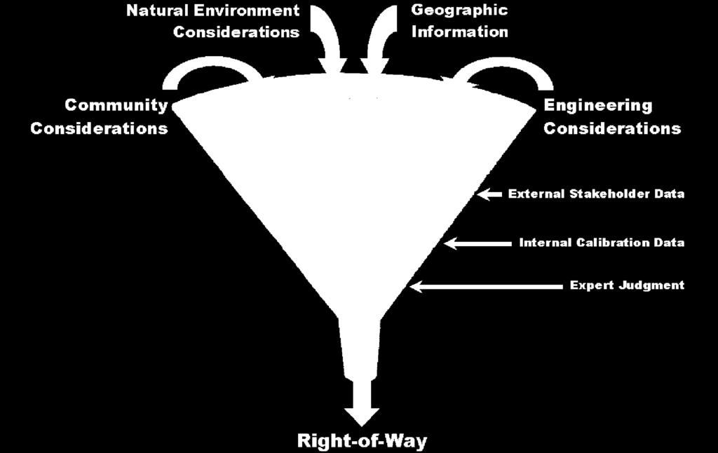
11 Environmental Assessment - VECs VECs currently being considered for the St. Vital Transmission Complex include: wildlife habitat native prairie employment and business opportunities property and residential development Aboriginal lands agricultural productivity agricultural land uses communication and transportation human health public safety aesthetics
12 Environmental Assessment Examination of Effects To assess the potential environmental effects of the project, the following will be undertaken: identification and assessment of potential environmental effects of the project on VECs. identification of mitigation measures for environmental effects on VECs. identification of methodology for determining significance of environmental effects on VECs. identification of measurable parameters to quantify and evaluate the significance of environmental effects on VECs. an assessment of cumulative effects on identified VECs.
13 4.0 Public Engagement Round 1 - August Introduce the Project. Present Alternative Routes. Answer questions. Identify and document concerns. Use input to guide Preferred Route selection process. Round 2 - October Present findings of Round 1. Present the Preferred Route. Answer questions. Identify and document outstanding concerns. Provide opportunity to discuss potential effects and possible mitigation measures to minimize effects. Input will also be gained through: Initial stakeholder meetings or discussions. Key person interviews (KPI). Workshops. Comments received by telephone, and on the Project website.
14 5.0 Timelines and Next Steps September Preferred Route identified and site specific field work to continue October Round 2 Public Open House Events November Ongoing design and environmental assessment December Anticipated Submission of Environmental Assessment to Manitoba Conservation and Water Stewardship and posting on public registry Mid 2016 Anticipated in-service date for St. Vital to Letellier Transmission Project. Anticipated project completion in 2017.
15 Questions? Additional project information is available at: Phone Licensing & Environmental Assessment at toll-free or in Winnipeg project team at:


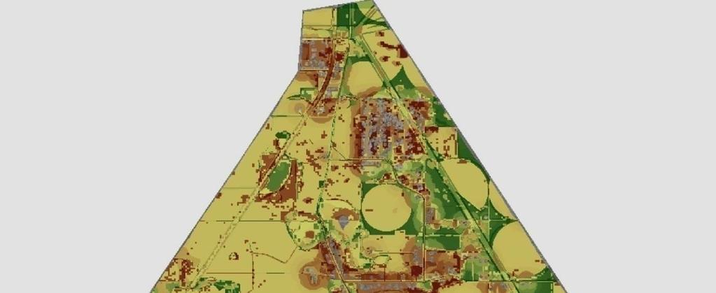
16 St. Vital Transmission Complex Project Infrastructure Alternative Routes St. Vital to La Verendrye Transmission Line (Within Southern Loop Transmission Corridor) UV 631 Ste. Agathe UV 305 UV 622 Tourond Composite Osborne Alternate Corridor Infrastructure Electrical Station [\ 52 Landbase!( Community Provincial Highway Otterburne UV 623 Kleefeld Provincial Road Rural Municipality UV 330 First Nation Hochstadt UV 216 National/Provincial Park t Wildlife Management Area Waterbody McTavish Watercourse UV 205 Carey St-Pierre-Jolys verside LA VERENDRYE STATION City of Winnipeg ST. VITAL STATION RM OF MORRIS RM OF DE SALABERRY [\ 59 UV 246 Niverville Steinbach UV 200 Morris [\ 75 [\ 23 Ste. Elizabeth UV 633 UV 606 Dufrost La Rochelle RM OF MONTCALM St. Malo UV 403 LETELLIER STATION Dominion City UV 629 St. Jean Baptiste RM OF MONTCALM St. Malo Wildlife Management Area UV 628 Arnaud UV 217 Carlowrie UV 218 Se [\ 14 Green Ridge UV 420 St. Joseph Letellier Roseau River Reserve (Ginew P.O.) UV 604 Dominion City UV 201 RM OF FRANKLIN Wood LETELLIER STATION Coordinate System: UTM Zone 14N NAD83 Data Source: MB Hydro, Stantec, PGS, ProvMB, NRCAN Date Created: August 19, Kilometres ± Ridgeville Composite Corridor and Alternative Routes St. Vital Transmission Complex O Miles 1:150,000 Draft: For Discussion Purposes Only Map # 3

17 Proposed St. Vital Transmission Complex Round 1 - Alternative Routes Round 1 - Alternative Routes Project need In order to improve system reliability and accommodate the growth and demand for electricity in southern Manitoba, Manitoba Hydro is proposing construction of two 230-kilovolt (kv) transmission lines, both originating at the St. Vital Station, located in southeastern Winnipeg. One line will run south to the Letellier Station and the other will run west to the La Verendrye Station located near the community of Oak Bluff. Project description The new line between the St. Vital and La Verendrye stations will be located on an existing Manitoba Hydro right-of-way south of Winnipeg known as the Southern Loop. This portion of the Project will enable the Winnipeg electrical network to withstand various severe outages, improve performance during normal operation and promote the reliability of the power system in southern Manitoba. Project location The new line between St. Vital Station and the Letellier Station will be routed through south central Manitoba, near Steinbach, to accommodate a potential future 230-kV station. This portion of the Project is required to address load and voltage concerns in the south central area of Manitoba due to load growth. Environmental characterization underway Manitoba Hydro has begun to collect information that will contribute to the selection of a transmission line route and environmental assessment of the Project. Once a route is determined, this information will help the Project team understand the landscape in order to determine any potential effects the Project may have on: Project Facts The proposed St. Vital Transmission Complex includes two 230-kV transmission lines. Both will start at the St. Vital Station located in southeastern Winnipeg: One new line will run south to the Letellier Station, passing close to Steinbach. The other new line will run to La Verendrye Station, within an existing right-of-way known as the Southern Loop. The engagement process includes: Round 1, August 2013: presentation of alternative routes. Round 2, October 2013: presentation of preferred route. The Project s Environmental Assessment Report is scheduled to be submitted in December The anticipated Project completion date is physical, terrestrial and aquatic environments. heritage resources. land use. socio-economic environment.


18 Route Selection and Environmental Assessment Processes Manitoba Hydro is piloting a new process to develop alternative routes for the St. Vital to Letellier transmission line. Known as EPRI-GTC Methodology, this process allows for early stakeholder input and incorporates engineering, built and natural environment considerations. The process involves stakeholders identifying, weighting and scoring alternative corridor selection factors, leading to the identification of alternative corridors to begin siting alternative routes. Feedback provided will assist in the identification of a preferred route for the new transmission line. The development of the proposed transmission lines will require a Class 2 licence under The Environment Act (Manitoba). An environmental assessment generally consists of: characterization of the environment. identification of potential effects on people and the environment. determination of methods to avoid or reduce potential effects while enhancing beneficial effects. The environmental assessment, including the public engagement process, will be documented in an Environmental Assessment Report and is anticipated to be submitted to regulatory authorities by end of Engagement Process Manitoba Hydro will undertake two rounds of engagement to gather feedback at different stages in the transmission line and assessment processes. The engagement process will include discussions with landowners, First Nations, the Manitoba Metis Federation, municipalities and other stakeholders. Manitoba Hydro will: inform the public regarding the Project, timelines and route selection process. utilize a variety of mechanisms to receive and share information with interested individuals. gather feedback on the local environment to assist routing the transmission lines as well as the environmental assessment. provide opportunities to have questions answered and concerns addressed by Manitoba Hydro representatives. Manitoba Hydro will undertake stakeholder workshops, open houses and meetings to collect information which will assist with determining a route that minimizes the impact on people and the environment. ST. VITAL TRANSMISSION COMPLEX
 Infrastructure Landbase Transmission Line Electrical Station City / Town First Nation National/Provincial Park")
19 Alternative Routes St. Vital Transmission Complex Project Infrastructure Composite Alternative Route Corridor Alternative Routes for the St. Vital to Letellier Transmission Line St. Vital to La Verendrye Transmission Line (Within Southern Loop Transmission Corridor) Infrastructure Landbase Transmission Line Electrical Station City / Town First Nation National/Provincial Park Provincial Highway Provincial Road Railway Southern Loop Transmission Corridor The Southern Loop is a dedicated transmission corridor that will accommodate multiple transmission lines necessary for system reliability and to meet future energy demands. Located between the Dorsey Converter Station (near Rosser) and the Riel Station (east of Winnipeg), the transmission corridor follows the western and southern boundaries of the City of Winnipeg. It connects to the LaVerendrye Station, near Oak Bluff. Manitoba Hydro has been acquiring property rights for the Southern Loop for many years. The Southern Loop will allow for multiple transmission lines within a single corridor, which would reduce the number of independent rights-of-way on the landscape. The St. Vital to La Verendrye transmission line will take advantage of this right-of-way.

20 Project Timeline Round 1 - August 2013 Introduce the Project. Present alternative routes. Answer questions. Identify and document concerns. Use input to guide preferred route selection process. Round 2 - October 2013 Present Round 1 findings. Present the preferred route. Answer questions. Identify and document outstanding concerns. Provide opportunity to discuss potential effects and possible mitigation measures to minimize or avoid effects. Next Steps Submit the Environmental Assessment Report. Regulatory authorities review report. Receipt of licence. Construction. Complete in-service date We are here. We would like to hear from you. There are a number of ways that you can participate in the review of this project and provide your input: attend an Open House. submit a comment sheet, available at the Open Houses or on our website (see address below). contact us directly. Questions or comments? Please contact: Trevor Joyal Licensing & Environmental Assessment Department Phone: LEAprojects@hydro.mb.ca
Alternative Routes. St. Vital to La Verendrye Station - Southern Loop Transmission Corridor. 20 different segments 4 segments common to all routes
 Alternative Routes St. Vital to La Verendrye Station - Southern Loop Transmission Corridor In a fixed right-of-way St. Vital to Letellier Station 20 different segments 4 segments common to all routes Goal
Alternative Routes Determined
 Alternative Routes Determined Preferred Route Selection Preferred Route Selection Expert judgment is used to determine the Final Preferred Route Takes into account feedback from Round One engagement and
Proposed St. Vital Transmission Complex
 Proposed St. Vital Transmission Complex Round 2 Preferred Route for the St. Vital to Letellier Line What is it? Manitoba Hydro is proposing construction of two 230-kilovolt (kv) transmission lines to improve
Presentation August 20, 2013
 Presentation August 20, 2013 St. Vital Transmission Complex Stakeholder Workshop WELCOME! Manitoba Hydro 9:00am to 1:50pm Purpose of Workshop Share current project information Including outcomes of the
Inform you of the purpose and scope of the study for PTH 100 and a proposed future St. Norbert Bypass;
 WELCOME The intent of today s Open House is to: Inform you of the purpose and scope of the study for PTH 100 and a proposed future St. Norbert Bypass; Review highway crossing locations, future access closures
CONSULTING SERVICES FOR THE WHITEBELT VISIONING EXERCISE ADDENDUM TO THE GTA WEST LAND USE STUDY WORK PROGRAM
 CONSULTING SERVICES FOR THE WHITEBELT VISIONING EXERCISE ADDENDUM TO THE GTA WEST LAND USE STUDY 1. Introduction WORK PROGRAM The Town of Caledon is a large, local municipality located in the Greater Toronto
Rapid Transit Implementation Working Group September 14, 2017
 Rapid Transit Implementation Working Group September 14, 2017 BACKGROUND Council approved the Rapid Transit Master Plan and Updated Business Case on July 25, 2017. Approval of the RTMP confirmed the BRT
Burloak Drive Grade Separation
 Burloak Drive Grade Separation Transit Project Assessment Process Public Meeting #1 March 30, 2017 GO Lakeshore West Service Plan Weekday Rush Hour 15-minute, two-way service between Aldershot* and Union
Master Environmental Servicing Plan & Secondary Plan
 East Side Lands Stage 2 1 Master Environmental Servicing Plan & Secondary Plan Public Information Centre #1 June 16, 2016 Welcome! Today s Agenda Please sign in at the front desk. 5:30 pm 6:30 pm: Open
HAZARD MITIGATION GOALS AND OBJECTIVES
 SEWRPC Community Assistance Planning Report No. 282, 2nd Edition CITY OF MILWAUKEE ALL HAZARDS MITIGATION PLAN UPDATE Chapter IV HAZARD MITIGATION GOALS AND OBJECTIVES [NOTE: Throughout this plan update
APPENDIX L3. Table of Contents. SWP EA Information Sheets
 E N V I R O N M E N T A L A S S E S S M E N T APPENDIX L3 SWP EA Information Sheets Table of Contents EA Info Sheet 1... L3-1 EA Info Sheet 2... L3-3 EA Info Sheet 3... L3-5 EA Info Sheet 4... L3-7 SCARBOROUGH
Rapid Transit Implementation Working Group
 Rapid Transit Implementation Working Group October 12, 2017 1 Agenda 1. Consultation Update 2. Technical Work Update 3. LTC Rapid Transit Integration 4. Next Steps 2 Consultation Update 3 Consultation
Leaside to Main Infrastructure Refurbishment Project
 N6667_Leaside to Main Panels Feb 2016_Clarington Panels 16-02-01 3:22 PM Page 1 Leaside to Main Infrastructure Refurbishment Project Strengthening the transmission system in your neighbourhood N6667_Leaside
Planning and Permitting
 SCE Transmission Project Planning and Permitting DRECP Stakeholder Meeting August 17, 2011 California s renewable energy and climate goals are among the most ambitious in the nation. Substantial investments
An Introduction to the Far North Land Use Strategy
 An Introduction to the Far North Land Use Strategy December, 2013 Ministry of Natural Resources Table of Contents PREFACE... 3 About the Far North... 3 Evolution of Land Use Planning in the Far North...
Project 6 All-Season Road Linking Manto Sipi Cree Nation, Bunibonibee Cree Nation & God s Lake First Nation
 Project 6 All-Season Road Linking Manto Sipi Cree Nation, Bunibonibee Cree Nation & God s Lake First Nation Possible Effects and Mitigation (Round 5) - Presentation to God s Lake Narrows March 24, 2017
Bostwick Road. Municipal Class Environmental Assessment. October 13, City of London. Bostwick Road Municipal Class Environmental Assessment
 Bostwick Road Municipal Class Environmental Assessment October 13, 2016 Welcome! Welcome to the first Public Information Centre for the Bostwick Road Municipal Class Environmental Assessment. Representatives
INTRODUCTION. Welcome to the third round of information events on the emerging Yorkshire Energy Park proposals. THE CONSULTANT TEAM WHERE IS THE SITE?
 1 INTRODUCTION Welcome to the third round of information events on the emerging Yorkshire Energy Park proposals. This is the third round of information events that we have undertaken on the project, following
Elfrida Growth Area Study
 Elfrida Growth Area Study Public Information Centre #2 December 6, 2017 6:00-8:30 pm PLANNING & ECONOMIC DEVELOPMENT DEPARTMENT Purpose of the Study The Elfrida Area has been identified as the preferred
One River Environmental Assessment. Welcome!
 One River Environmental Assessment Welcome! One River Environmental Assessment Welcome to the One River Environmental Assessment Public Information Centre. Please explore each presentation area to learn
MAYFIELD WEST SECONDARY PLAN PHASE 2
 MAYFIELD WEST SECONDARY PLAN PHASE 2 Council Information Workshop February 16, 2010 Draft Preferred Land Use Plan TOWN OF CALEDON PLANNING & DEVELOPMENT DEPARTMENT Workshop Agenda TOWN OF CALEDON 1. Welcome
APPENDIX I Presentations
 APPENDIX I Presentations Workshop Summary Report 11 Peel Region Official Plan Review May 5, 2010 Compatible Active Recreation Workshop July 29, 2010 Components of PROPR Sustainability Planning Tools/Updates
Planning for the Future Urban Area. in north Markham. Update. Development Services Committee. December 9, De Development Services Committee
 Planning for the in north Markham 1 Update De December 9, 2014 Overview - Growth Management Strategy and new Official Plan 2014 Status - Official Plan 2014 and ROPA3 Update - Planning for the Future Urban
Presentation Overview
 DETROIT RIVER INTERNATIONAL CROSSING STUDY Presentation to Windsor Rotary Club October 23, 2006 1 Presentation Overview 1. Overview 2. Progress Update Technical Work Program Environmental Work Program
JOINT PUBLIC NOTICE. 26 June United States Army Corps of Engineers State of Louisiana
 JOINT PUBLIC NOTICE 26 June 2017 United States Army Corps of Engineers State of Louisiana New Orleans District Department of Environmental Quality Regulatory Branch Office of Environmental Services 7400
Canadian Cataloguing in Publication Data Main entry under title: Managing our heritage resources: impact assessment.
 Canadian Cataloguing in Publication Data Main entry under title: Managing our heritage resources: impact assessment. Rev ed. Previously published 1993 in separate English and French eds. Text in English
APPENDIX 1. Long Range Planning and the Vision for the Future of the Town
 APPENDIX 1 Long Range Planning and the Vision for the Future of the Town Long Range Planning and the Vision for the Future of the Town Given the requirements of the Provincial Policy Statement and Growth
CITY OF VAUGHAN EXTRACT FROM COUNCIL MEETING MINUTES OF NOVEMBER 15, 2016
 Item 11, Report No. 38, of the Committee of the Whole, which was adopted without amendment by the Council of the City of Vaughan on November 15, 2016. Regional Councillor Di Biase declared an interest
SPECIAL COMMITTEE OF THE WHOLE DECEMBER 9, 2002 BLOCK 57/58 WEST BLOCK PLAN BLOCK PLAN FILE BL.57/58W.99 HUNTINGTON BUSINESS PARK LAND OWNERS
 SPECIAL COMMITTEE OF THE WHOLE DECEMBER 9, 2002 BLOCK 57/58 WEST BLOCK PLAN BLOCK PLAN FILE BL.57/58W.99 HUNTINGTON BUSINESS PARK LAND OWNERS Recommendation The Commissioner of Planning recommends: THAT
TRCA Field Staking Protocol December 2016
 Page 1 of 6 TRCA Field Staking Protocol December 2016 This Protocol describes TRCA staff s current practice for field staking the physical top of bank, the physical toe of slope, and the limit of existing
April Parker Lands Major Redevelopment Site Environmental Overview. Submitted to: Prepared by:
 April 2017 Parker Lands Major Redevelopment Site Environmental Overview Submitted to: 6165347 Manitoba Inc. 1383 Spruce Street Winnipeg, Manitoba R3E 2V8 Prepared by: EcoLogic Environmental Inc. Wildlife,
GTA West Transportation Corridor EA Study Stage 2. Introductory Community Workshop
 GTA West Transportation Corridor EA Study Stage 2 Introductory Community Workshop 1 Today s Agenda The GTA West Project Team Study overview Interactive exercises and one-on-one discussions with the Project
Ashbridges Bay Erosion and Sediment Control Project
 Ashbridges Bay Erosion and Sediment Control Project Project Brief Overview Toronto and Region Conservation Authority, in partnership with the City of Toronto, intends to carry out remedial erosion control
Lower Don River West Remedial Flood Protection Project TABLE OF CONTENTS. Page. Executive Summary
 TABLE OF CONTENTS Page Executive Summary 1.0 INTRODUCTION...1-1 1.1 Purpose of the Undertaking...1-1 1.2 Study Area Description...1-1 1.3 Description of the Undertaking...1-1 1.4 Rationale for the Undertaking...1-2
DOMINION BOULEVARD CORRIDOR STUDY AND ECONOMIC DEVELOPMENT STRATEGIC PLAN A MODEL FOR CHESAPEAKE S FUTURE
 DOMINION BOULEVARD CORRIDOR STUDY AND ECONOMIC DEVELOPMENT STRATEGIC PLAN A MODEL FOR CHESAPEAKE S FUTURE Overview I. Draft Plan Process II. Draft Plan Overview a. Market Analysis b. Master Land Use Plan
Environmental Impact Assessment
 Environmental Impact Assessment Environmental impact assessment (EIA) is the process of systematically drawing together an assessment of the likely significant environmental effects of a development project.
University Park, Worcester Non Technical Summary December 2011
 University Park, Worcester Non Technical Summary December 2011 Introduction UW Wrenbridge LLP, a Joint Venture Company of the University of Worcester and Wrenbridge Land Ltd (the Applicants ) intend to
South of Eastern Strategic Direction Status Update
 STAFF REPORT ACTION REQUIRED South of Eastern Strategic Direction Status Update Date: July 10, 2014 To: From: Planning and Growth Management Committee Chief Planner and Executive Director, City Planning
Spencer Environmental 3.0 METHODS
 3.0 METHODS 3.1 General Methods Following is a summary of the main steps and activities employed in the preparation of this EISA. These were not necessarily sequential steps; many were iterative. We participated
Portage Parkway Environmental Assessment Public Information Centre No. 1
 City of Vaughan Portage Parkway Environmental Assessment Public Information Centre No. 1 November 25, 2015 Welcome to the Public Information Centre This first Public Information Centre (PIC) introduces
Report to: Development Services Committee Report Date: September 11, 2017
 ~RKHAM Report to: Development Services Committee Report Date: September 11, 2017 SUBJECT: PREPARED BY: Conceptual Master Plan for the Future Urban Area - Community Structure Plan and Key Policy Direction
Western Pennsylvania Conservancy Clairton & Harrison Community Greening Assessment Projects Request for Proposals July 2018
 Western Pennsylvania Conservancy Clairton & Harrison Community Greening Assessment Projects Request for Proposals July 2018 Proposal Information The Western Pennsylvania Conservancy (WPC) is seeking proposals
Kibworth Harcourt. Introduction. Introduction
 Introduction Introduction Welcome to this public exhibition on the proposals for the delivery of new homes on land at The Kibworths. The purpose of today s exhibition is to give you the opportunity to
PART 1. Background to the Study. Avenue Study. The Danforth
 The Danforth 1.1/ Study Purpose & Key Municipal Goals 1.2/ The Local Advisory Committee 1.3/ The Project Team 1.4/ Study Process/Summary of Method 1.5/ Summary of Consultation 1.1 Study Purpose and Key
SCARBOROUGH SUBWAY EXTENSION. Scarborough Subway Extension. Final Terms of Reference
 Scarborough Subway Extension Final Terms of Reference 1 1.0 Introduction and Background 1.1 Introduction Toronto City Council recently confirmed support for an extension of the Bloor-Danforth Subway from
1 Introduction. Chapter. In this chapter:
 Chapter 1 Introduction In this chapter: 1.1 A Snapshot of the Region 1.2 Towards a Sustainable Region 1.3 The Provincial Context 1.4 Purpose and Organization The Regional Municipality of York Official
APPENDIX F: EXTERNAL APPROVALS
 1.0 RESPONSIBILITIES When the City is constructing the Park or Open Space Development lands (OPTION I), after the subdivision construction process is completed by the Developer, Open Space Development
Ashbridges Bay TTC Maintenance and Storage Facility
 Ashbridges Bay TTC Maintenance and Storage Facility September 8, 2010 Presented to Government Review Team 1 Presentation Overview Overview of the Project Status of Transit Project Assessment Process Potential
SOUTHWEST TRANSITWAY (STAGE 2) PUBLIC OPEN HOUSE
 PUBLIC OPEN HOUSE") WELCOME! SOUTHWEST TRANSITWAY (STAGE 2) PUBLIC OPEN HOUSE Monday, November 18, 2013 3:30 to 5:30PM and 7:00 to 9:00PM Tuesday, November 19, 2013 3:30 to 5:30PM and 7:00 to 9:00PM Welcome to the Southwest
WELCOME! SOUTHWEST TRANSITWAY (STAGE 2) PUBLIC OPEN HOUSE Monday, November 18, 2013 3:30 to 5:30PM and 7:00 to 9:00PM Tuesday, November 19, 2013 3:30 to 5:30PM and 7:00 to 9:00PM Welcome to the Southwest
Welcome to the Oakridge Centre Open House
 Welcome to the Oakridge Centre Open House Why is the City hosting this event? This open house is to inform you of a rezoning application submitted to the City of Vancouver to amend the existing CD-1 (Comprehensive
What We Heard Public Engagement - Stage 1
 What We Heard Public Engagement - Stage 1 Background Early planning is underway for a potential new river crossing over the North Saskatchewan River, in the northeast part of the Edmonton region. The City
Canyon Lake Master Plan Revision Public Information Meeting March 18, 2016
 Canyon Lake Master Plan Revision Public Information Meeting March 18, 2016 Marcus Schimank Canyon Lake Manager Capital Regional Office U.S. Army Corps of Engineers Fort Worth District US Army Corps of
Edgeley Pond + Park Public Meeting
 Edgeley Pond + Park Public Meeting February 21, 2017 Purpose of the meeting This Public Meeting is an opportunity for you to review the project background, process and provide input. City of Vaughan staff
WHITELEY TOWN COUNCIL NORTH WHITELEY DEVELOPMENT SEPTEMBER 2014
 WHITELEY TOWN COUNCIL NORTH WHITELEY DEVELOPMENT SEPTEMBER 2014 Dear Resident This Special Edition of the Whiteley Voice which has been prepared in conjunction with the North Whiteley Consortium is to
~!VAUGHAN NOV Z November 21, Mr. Denis Kelly, Regional Clerk The Regional Municipality of York Yonge Street Newmarket, ON L3Y 6Z1
 ~!VAUGHAN NOV Z 5 2016 November 21, 2016 Mr. Denis Kelly, Regional Clerk The Regional Municipality of York 17250 Yonge Street Newmarket, ON L3Y 6Z1 Dear Mr. Kelly: RE: NEW KIRBY GO STATION IN BLOCK 27
California Environmental Quality Act (CEQA) Environmental Review Process
 Environmental Review Process") California Environmental Quality Act (CEQA) Environmental Review Process Los Angeles Union Station Forecourt and Esplanade Improvements constitute a Project Los Angeles County Metropolitan Transportation
California Environmental Quality Act (CEQA) Environmental Review Process Los Angeles Union Station Forecourt and Esplanade Improvements constitute a Project Los Angeles County Metropolitan Transportation
MAYFIELD WEST SECONDARY PLAN PHASE 2
 MAYFIELD WEST SECONDARY PLAN PHASE 2 Public Open House #3 February 25, 2010 Draft Preferred Land Use Scenario TOWN OF CALEDON PLANNING & DEVELOPMENT DEPARTMENT Open House Agenda TOWN OF CALEDON 1. Welcome
9 CITY OF VAUGHAN OFFICIAL PLAN AMENDMENT NO BOCA EAST INVESTMENTS LIMITED
 9 CITY OF VAUGHAN OFFICIAL PLAN AMENDMENT NO. 631 - BOCA EAST INVESTMENTS LIMITED The Planning and Economic Development Committee recommends the adoption of the recommendations contained in the following
Member Service Plan Sierra Nevada AmeriCorps Partnership
 Member Service Plan Sierra Nevada AmeriCorps Partnership Service plans lay the framework for what each Member will be doing during their service. Service plans detail the major projects and expected results
March 21, 2018 ALCA Meeting. March 21, 2018
 March 21, 2018 ALCA Meeting March 21, 2018 Agenda 1. Process and Timeline 2. Original Submission 3. Revised Submission 4. Next Steps The City of Calgary Role: The City is responsible for capturing and
The Illinois Department of Transportation and Lake County Division of Transportation. Route 173, including the Millburn Bypass
 The Illinois Department of Transportation and Lake County Division of Transportation welcome you to this Public Hearing for U.S. Route 45 from Illinois Route 132 to Illinois Route 173, including the Millburn
New Brighton Park Shoreline Habitat Restoration Project
 Vancouver Board of Parks and Recreation and Port Metro Vancouver New Brighton Park Shoreline Habitat Restoration Project Conceptual Design Public Consultation August 26 September 9, 2015 Discussion Paper
Blackfriars Bridge Municipal Class Environmental Assessment. Public Information Centre #1 November 19 th, 2014
 Blackfriars Bridge Municipal Class Environmental Assessment Public Information Centre #1 November 19 th, 2014 Why are you here tonight? To determine the future requirements of the river crossing at Blackfriars
Municipal Obligations Archaeological Heritage Screening. Heritage Conservation Branch Ministry of Parks, Culture and Sport November 14, 2018
 Municipal Obligations Archaeological Heritage Screening Heritage Conservation Branch Ministry of Parks, Culture and Sport November 14, 2018 Legislative Authority: The Heritage Property Act, 1980 Impact
Pine Flat Lake Master Plan Update FACT SHEET September 2014
 Pine Flat Lake Master Plan Update FACT SHEET September 2014 PURPOSE AND OBJECTIVE The U.S. Army Corps of Engineers Sacramento District is revising the 1976 Pine Flat Lake Master Plan and is seeking public
Rannoch 132 / 33 kv Substation Extension
 Who we are Scottish and Southern Energy Power Distribution is part of the SSE plc group of companies. We own, maintain and invest in the networks in the north of Scotland the electricity transmission network
TOWN OF BRUDERHEIM Report to the capital region board
 TOWN OF BRUDERHEIM Report to the capital region board Introduction to the Town of Bruderheim Municipal Development Plan amendment and Relation to the CRB Evaluation Criteria 02 march 2017 1 Introduction
Application for Certificate of Environmental Compatibility and Public Need
 Application for Certificate of Environmental Compatibility and Public Need Central Hudson Gas & Electric A and C Lines Towns of Pleasant Valley, LaGrange, Wappinger, and East Fishkill Dutchess County,
7.0 SOCIAL, ECONOMIC, AND ENVIRONMENTAL ISSUES
 7.0 SOCIAL, ECONOMIC, AND ENVIRONMENTAL ISSUES The following list of social, economic, and environmental issues have been identified based on a preliminary inventory of resources in the project area, an
Vaughan Metropolitan Centre (VMC) Black Creek Renewal CLASS ENVIRONMENTAL ASSESSMENT
 Black Creek Renewal CLASS ENVIRONMENTAL ASSESSMENT") PUBLIC INFORMATION CENTRE Vaughan Metropolitan Centre (VMC) Black Creek Renewal Wednesday, May 10, 2017 6:00 p.m. to 8:00 p.m. Add photo Project Management, Environmental Assessment, Stormwater Management
PUBLIC INFORMATION CENTRE Vaughan Metropolitan Centre (VMC) Black Creek Renewal Wednesday, May 10, 2017 6:00 p.m. to 8:00 p.m. Add photo Project Management, Environmental Assessment, Stormwater Management
Scarborough Waterfront Project
 Scarborough Waterfront Project Public Information Centre #1 Environmental Assessment Terms of Reference September 10, 2014 Agenda Open House Presentation 7:00 to 7:30 pm Presentation 7:30 to 8:15 pm History
CHAPTER 1: INTRODUCTION
 CHAPTER 1: INTRODUCTION MAP OF OUTAGAMIE COUNTY, WI N 1 = 6 miles INTRODUCTION The Town and Village of Black Creek are located in central Outagamie County, Wisconsin. The Village is located in the north
NORTHEAST RIVER CROSSING FUNCTIONAL PLANNING STUDY
 WELCOME Northeast River Crossing Functional Planning Study Phase 2 Public Meeting 4 to 8 PM Informal drop-in format and discussion tables Meeting Purpose Introduce the Northeast River Crossing Functional
THE CORPORATION OF THE CITY OF WINDSOR Office of the City Solicitor Planning Department
 THE CORPORATION OF THE CITY OF WINDSOR Office of the City Solicitor Planning Department REPORT TO THE CITY OF WINDSOR PLANNING ADVISORY COMMITTEE DATE OF REPORT: August 19, 2010 SUBJECT: Official Plan
Public Information Meeting
 Lavon Lake Master Plan Revision Public Information Meeting March 10, 2015 Presented By Michael Kinard Lake Manager U.S. Army Corps of Engineers Fort Worth District US Army Corps of Engineers Purpose of
Appendix 1 Structure plan guidelines
 Appendix 1 Structure plan guidelines This appendix forms part of the regional policy statement [rps]. 1.1. Introduction Structure plans are an important method for establishing the pattern of land use
4. What are the goals of the Kawarthas, Naturally Connected project? 7. What are watersheds and why are they being used as the project boundaries?
 Frequently Asked Questions (FAQs) 1. What are Natural Heritage Systems (NHS)? 2. Why are they important? 3. Which areas of the province have undertaken NHS projects? 4. What are the goals of the Kawarthas,
The Village of Sugar Grove, in partnership with Kane County, the Illinois Department of Transportation, and the Illinois Tollway welcomes you to the
 The Village of Sugar Grove, in partnership with Kane County, the Illinois Department of Transportation, and the Illinois Tollway welcomes you to the first Public Meeting for the proposed interchange improvement
DEVELOPMENT PERMIT SENSITIVE ECOSYSTEMS
 DEVELOPMENT PERMIT SENSITIVE ECOSYSTEMS What is the Sensitive Ecosystem Development Permit Area (SEDPA)? Surrey s SEDPA is made up of two distinct classifications of the natural environment: Streamside
Meeting Agenda. City of Guelph. River Systems Advisory Committee. Agenda Items. Item 1, 2 and 3. Item 4 Ward to Downtown Pedestrian Bridge
 Meeting Agenda City of Guelph River Systems Advisory Committee September 19, 2018 City Hall, Meeting Room B From 4:00 to 6:00 p.m. Meeting Chair: Mariette Pushkar Agenda Items Welcome to all Item 1, 2
Thank you for coming. We want to hear your views on proposed improvements to the A1 between junction 65 (Birtley) and junction 67 (Coal House).
 and junction 67 (Coal House).") Welcome Thank you for coming. We want to hear your views on proposed improvements to the between junction 65 (Birtley) and junction 67 (Coal House). This is your opportunity to provide comments on our
Welcome Thank you for coming. We want to hear your views on proposed improvements to the between junction 65 (Birtley) and junction 67 (Coal House). This is your opportunity to provide comments on our
Managing our Landscapes Conversations for Change
 Managing our Landscapes Conversations for Change Frequently Asked Questions The new State Government is committed to a significant reform program that will change the way natural resources are managed.
Project 6 All-Season Road Linking Manto Sipi Cree Nation, Bunibonibee Cree Nation & God s Lake First Nation
 Project 6 All-Season Road Linking Manto Sipi Cree Nation, Bunibonibee Cree Nation & God s Lake First Nation The Environmental Assessment - Presentation to Bunibonibee Cree Nation December 8, 2016 Why are
Call for Proposals. Heritage, natural capital and ecosystem services: case studies. Project No: Date of Issue: Tuesday 14 th November 2017
 Call for Proposals Heritage, natural capital and ecosystem services: case studies Project No: 7705 Date of Issue: Tuesday 14 th November 2017 Summary Historic England is seeking expressions of interest
COMMUNITY SUSTAINABILITY AND ENVIRONMENTAL MASTER PLAN IMPLEMENTATION UPDATE
 Attachment 1 COMMUNITY SUSTAINABILITY AND ENVIRONMENTAL MASTER PLAN IMPLEMENTATION UPDATE Priorities and Key Initiatives Committee May 2013 Page E-1 How we grow Goal 2: To ensure sustainable development
ONE RIVER MASTER PLAN ENVIRONMENTAL ASSESSMENT
 ONE RIVER MASTER PLAN ENVIRONMENTAL ASSESSMENT TERMS OF REFERENCE 1. ONE RIVER PROJECT OVERVIEW At its meeting on May 17, 2016, Council considered a staff report regarding the One River Master Plan Environmental
CITY OF VAUGHAN EXTRACT FROM COUNCIL MEETING MINUTES OF DECEMBER 10, 2013
 Item 1, Report No. 55, of the Committee of the Whole (Working Session), which was adopted without amendment by the Council of the City of Vaughan on December 10, 2013. Regional Councillor Di Biase declared
ALL SECURE SELF STORAGE SEPA APPEAL RECOMMENDATION TO THE HEARING EXAMINER
 KITSAP COUNTY DEPARTMENT OF COMMUNITY DEVELOPMENT 619 DIVISION STREET MS-36, PORT ORCHARD WASHINGTON 98366-4682 LOUISA GARBO, DIRECTOR (360) 337-5777 FAX (360) 337-4415 HOME PAGE - www.kitsapgov.com ALL
St. Clair Avenue West Area Transportation Master Plan
 1 (Between Keele Street and Old Weston Road) Public Information Centre 1 December 2, 2015 2 Welcome Welcome to the first Public Information Centre for the St. Clair Avenue West Area. The panels will present
PDS June 1, 2016 Page 1. Planning and Development Committee. MEETING DATE: Wednesday, June 01, 2016
 Page 1 REPORT TO: Planning and Development Committee MEETING DATE: Wednesday, June 01, 2016 SUBJECT: ROPA 12: Project Initiation Report Regional Official Plan Amendment (ROPA # 12) Watercourse Policies
WASHINGTON COUNTY OREGON
 WASHINGTON COUNTY OREGON LONG RANGE PLANNING DIVISION North Bethany Subarea Stream Corridors: Existing Regulations In Oregon, there is a distinct difference between the land use rules that apply in rural
12 AMENDMENT NO. 149, TOWN OF MARKHAM HIGHWAY 404 NORTH SECONDARY PLAN
 12 AMENDMENT NO. 149, TOWN OF MARKHAM HIGHWAY 404 NORTH SECONDARY PLAN The Planning and Economic Development Committee recommends the adoption of the recommendation contained in the following report August
The West Vaughan Employment Area Secondary Plan Policies
 Part 2: The West Vaughan Employment Area Secondary Plan Policies 2.1 General Policies It is the policy of Council: 2.1.1. That the West Vaughan Employment Area (the WVEA), identified on Schedule 1, will
Lake O the Pines Master Plan Revision Public Information Meeting April 25 & 27, 2017
 Lake O the Pines Master Plan Revision Public Information Meeting April 25 & 27, 2017 Presented By Matthew Like, Lake Manager U.S. Army Corps of Engineers Fort Worth District US Army Corps of Engineers
Background Summary Report
 Background Summary Report May 2014 Submitted by Macaulay Shiomi Howson Ltd. In association with AMEC MMM Group Brook McIlroy Inc. Hemson Consulting Ltd. Table of Contents 1. Introduction... 1 2. Why is
systems is available on the Colorado Wetland Information Center (CWIC) website.
 website.") Colorado Natural Heritage Program Wetland Program Plan -- Dec 2015 Status Update and Addendum -- The Colorado Natural Heritage Program (CNHP) developed a Wetland Program Plan (WPP) in 2010 for the planning
Colorado Natural Heritage Program Wetland Program Plan -- Dec 2015 Status Update and Addendum -- The Colorado Natural Heritage Program (CNHP) developed a Wetland Program Plan (WPP) in 2010 for the planning
Atlanta BeltLine Corridor Environmental Study. Scoping Meeting August 2008
 Atlanta BeltLine Corridor Environmental Study Scoping Meeting August 2008 What Will We Be Discussing Today? Study Overview - How Did We Get Here? - What Is the Study About? - Who Is Involved? - Where Is
Public Open House. Yonge Street and Bernard Avenue (Bernard KDA) Planning Study Update Town of Richmond Hill. March 30, 2017
 Planning Study Update Town of Richmond Hill. March 30, 2017") Public Open House Yonge Street and Bernard Avenue (Bernard KDA) Planning Study Update Town of Richmond Hill March 30, 2017 Open House Review of Project Purpose and Process Policy Refresher Highlights of
Public Open House Yonge Street and Bernard Avenue (Bernard KDA) Planning Study Update Town of Richmond Hill March 30, 2017 Open House Review of Project Purpose and Process Policy Refresher Highlights of
MDX SR 836/DOLPHIN EXPRESSWAY SOUTHWEST EXTENSION
 MDX SR 836/DOLPHIN EXPRESSWAY SOUTHWEST EXTENSION Project Development and Environment (PD&E) STUDY Miami-Dade County, Florida Preliminary Executive Summary Alternative Corridor Evaluation (ACE) Report
3-2 Environmental Systems
 3-2 Environmental Systems 3.0 ENVIRONMENTAL SYSTEMS CONTENTS 3.1 GREENWAY SYSTEM 3.1.1 General Policies 3.1.2 Natural Heritage Network 3.1.3 Natural Heritage Network Enhancement Lands 3.1.4 Rouge Watershed