GTA West Transportation Corridor EA Study Stage 2. Introductory Community Workshop
|
|
|
- Jared McDonald
- 5 years ago
- Views:
Transcription


1 GTA West Transportation Corridor EA Study Stage 2 Introductory Community Workshop 1
2 Today s Agenda The GTA West Project Team Study overview Interactive exercises and one-on-one discussions with the Project Team Application for Community Advisory Group & Greenbelt Transportation Advisory Group Things to Consider for Route and Interchange Alternatives What Features are Important to You? Where Should the Route Go? 2
3 The GTA West Project Team Natalie Rouskov, MTO: Project Manager Chris Barber, MTO: Environmental Planner Sarah Merriam, MTO: Consultation Lead and Environmental Planner Neil Ahmed, MMM: Consultant Project Manager Tim Sorochinsky, URS: Manager West Section Brenda Jamieson, AECOM: Manager Central Section Jim Dowell, MMM: Manager East Section Sandy Nairn, MMM: Environmental Planning Lead Patrick Puccini, URS: Consultation Lead 3
4 Planning with Vision, Planning for People Our philosophy is. To follow an open and transparent process that provides equal opportunities for all stakeholders to help shape the outcome of the project To arrive at a recommended solution for the Transportation Corridor through the Route Planning Study Area that provides the best balance of benefits and impacts to the local communities and the users of the transportation system To accomplish this, we are committed to providing members of the local community and users of the transportation system with innovative and engaging consultation opportunities that enable active participation and the ability to help shape the outcome of this study in a meaningful way 4
5 Stage 1 of the Study Stage 1 of the GTA West Transportation Corridor Planning and EA Study was completed in November It recommended a multimodal strategy including: Optimize the existing transportation network Improvements to non-roadway transportation modes such as transit and rail Widening of existing highways A new transportation corridor Stage 2 of the Study This study (Stage 2) focuses on the recommendation for a new transportation corridor: Extending from Highway 400 in the east to the Highway 401/407 ETR interchange area in the west That includes a 400-series highway, a transitway, and potential goods movement priority features 5
6 6
7 Coordination with Other Studies Municipalities and other stakeholders may be conducting planning studies within MTO s GTA West Route Planning Study Area, however the planning for the GTA West transportation corridor and the ultimate identification of the preferred route is the responsibility of the province of Ontario (MTO) If you see references to GTA West, remember: MTO is considering the findings of these other studies, however they are only one piece of the larger puzzle MTO s GTA West Study Area is 50 km long, includes 10 municipalities, and many environmental and community features to consider. As a result, MTO s recommendation may differ from those of other planning studies Look for our logo to be sure you are getting the most accurate and up-to-date information about the GTA West Study Look for our Logo! 7

8 Key Issues West Section Highway 401 to Mississauga Road Interchange at Highway 401 / Highway 407 ETR Complex traffic flow Footprint compatibility with existing land use and municipal development plans Impacts to Sixteen Mile Creek Tributaries Numerous heritage properties Staging and detouring requirements Challenges in crossing the Credit River Designated employment lands Development areas Ability to accommodate proposed Norval Bypass 8

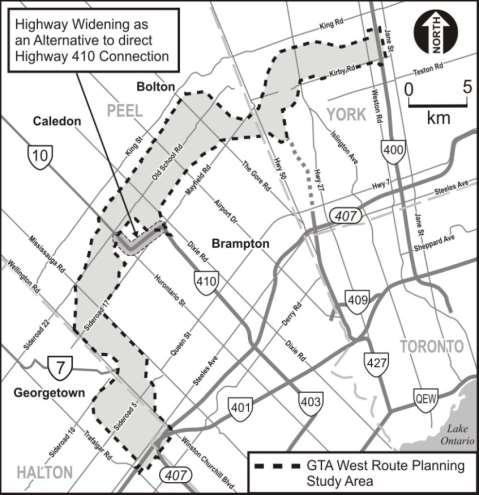
9 Key Issues Central Section Mississauga Road to Highway 50 Existing agricultural operations Future development areas Numerous watercourses Residential communities Highway 410 connection options: Complex traffic flow Footprint compatibility with existing land use and municipal development plans Partial interchange at Countryside Drive 9

10 Key Issues Eastern Section Highway 50 to Highway 400 Connection to Highway 400 Connection to Highway 427 Narrow section south of Bolton due to Humber River Tributaries, CP Rail, Hydro Substation, and local developments Highway 400 Employment Lands Challenges in crossing the Humber River Greenbelt / Protected Countryside Crossing of Hydro One 500 kv corridor 10
11 Helping to Reduce Uncertainty The Project Team is committed to moving forward as quickly as possible with this study A full set of route planning alternatives is under development and will be available for review later this year MTO objections to development applications can be lifted progressively, with additional consultation and associated documentation (following PIC1) Further removal of objections to development applications when: Preferred route has been identified and confirmed (following PIC 2) Preliminary design of preferred route has been completed (following PIC 3) All lands outside of the preferred route location, as denoted in the EA documentation, will be released once EA approval is obtained. 11
12 The New Corridor The new corridor will feature a 4- to 6-lane highway and a separate adjacent transitway Transitway stations will be located at interchanges and key connection points Truck priority features are also being actively explored 12
13 Greenbelt Design Guidelines The Draft Guideline for Planning and Design of the GTA West Corridor through the Greenbelt was developed in Stage 1 for application in Stage 2 Included input from representatives of various environmental agencies, ministries, and interest groups Key elements include: Impact avoidance, where possible Consideration of road ecology and wildlife Consideration of impacts to agriculture Stormwater management Bridge design over rivers and valleys Consideration of a reduced cross-section width through the Greenbelt Community Sensitive Design 13
14 Consultation Program Route Alternatives Evaluation of Alternatives Preliminary Design Draft Environmental Assessment Report Submission of Final Environmental Assessment Report Consultation Round 1 Consultation Round 2 Consultation Round 3 Minimum 90- Day Review Introductory Community Workshop Introductory MAG / RAAG meeting Agency meetings with: MAG, RAAG, MEAG, CAG, GTAG, Councils PIC #1 Second Community Workshop Meetings with First Nations and Métis Communities Meetings with other stakeholder groups Agency meetings with: MAG, RAAG, MEAG, CAG, GTAG, Councils PIC #2 Third Community Workshop Meetings with First Nations and Métis Communities Meetings with other stakeholder groups Community Value Plans Agency meetings with: MAG, RAAG, MEAG, CAG, GTAG, Councils PIC #3 Fourth Community Workshop Meetings with First Nations and Métis Communities Meetings with other stakeholder groups One-on-One Meetings with impacted property owners 14
 Stakeholder advisory groups, working groups, and Council presentations Project website: www.gta-west.")
15 Consultation & Engagement Program The consultation program features multiple outreach tools and points of contact: Public Information Centres (3 rounds) Community workshops (4 rounds) First Nation and Métis Council / Community Meetings (3 rounds) Stakeholder advisory groups, working groups, and Council presentations Project website: Project Team address: project_team@gta-west.com Follow us on Toll-free telephone line:
16 Next Steps Finalize existing conditions mapping (with your input tonight!) Develop route alternatives (with your input tonight!) Identify potential interchange locations (with your input tonight!) Meetings with municipal working groups Present findings to study stakeholders in Fall/Winter 2014: Stakeholder Advisory Group meetings (MAG, RAAG, CAG, GTAG, etc.) Council presentations Members of the public (Public Information Centre #1) 16
El-I. Request for Delegation
 U BRAMPTON brampton.ca Attention: FlOWef GltV El-I Request for Delegation Corporate Services Council and Administrative Services City Clerk's Office, City of Brampton, 2 Wellington Street West, Brampton
3 Ontario Ministry of Transportation s GTA West Transportation Corridor Environmental Assessment
 Clause 3 in Report No. 4 of Committee of the Whole was adopted, without amendment, by the Council of The Regional Municipality of York at its meeting held on March 24, 2016. 3 Ontario Ministry of Transportation
CONSULTING SERVICES FOR THE WHITEBELT VISIONING EXERCISE ADDENDUM TO THE GTA WEST LAND USE STUDY WORK PROGRAM
 CONSULTING SERVICES FOR THE WHITEBELT VISIONING EXERCISE ADDENDUM TO THE GTA WEST LAND USE STUDY 1. Introduction WORK PROGRAM The Town of Caledon is a large, local municipality located in the Greater Toronto
THE MINISTRY OF TRANSPORTATION S SUMBISSION FOR THE
 THE MINISTRY OF TRANSPORTATION S SUMBISSION FOR THE 2011 Transportation of Canada Environmental Achievement Awards 407 East Environmental Assessment Stakeholder Consultation Process / Community Value Plan
Mavis Road Class Environmental Assessment
 Mavis Road Class Environmental Assessment Public Information Centre #2 Wednesday November 9, 2016 6:00 to 8:00 p.m. Please sign in and complete a comment sheet Review the displays on your own or join in
Portage Parkway Environmental Assessment Public Information Centre No. 1
 City of Vaughan Portage Parkway Environmental Assessment Public Information Centre No. 1 November 25, 2015 Welcome to the Public Information Centre This first Public Information Centre (PIC) introduces
Route Planning and Environmental Assessment Study Highway 17 Four-Laning from Sudbury to Markstay GWP
 Route Planning and Environmental Assessment Study Highway 17 Four-Laning from Sudbury to Markstay GWP 5031-09-00 Presentation to City of Greater Sudbury Council: January 26, 2011 1 Roch Pilon, P.Eng. Head,
Background Summary Report
 Background Summary Report May 2014 Submitted by Macaulay Shiomi Howson Ltd. In association with AMEC MMM Group Brook McIlroy Inc. Hemson Consulting Ltd. Table of Contents 1. Introduction... 1 2. Why is
Second Line West Pedestrian/Cyclist Crossing of Highway 401 Class EA. Second Line West Pedestrian/Cyclist Crossing of Highway 401 Class EA
 1 1 Purpose of Public Information Centre #2 To provide interested and/or potentially affected stakeholders with an opportunity to participate in the planning and decision-making process for this Municipal
Public Information Centre #1
 and Highway 401 Interchange Improvements WELCOME Public Information Centre #1 Veterans Memorial Parkway Extension and Highway 401 Interchange Improvements Study May 23, 2012 4 p.m. to 7 p.m. Brief Overview
Rapid Transit Implementation Working Group September 14, 2017
 Rapid Transit Implementation Working Group September 14, 2017 BACKGROUND Council approved the Rapid Transit Master Plan and Updated Business Case on July 25, 2017. Approval of the RTMP confirmed the BRT
WELCOME TO OPEN HOUSE TWO November 28, 2018
 Langstaff Road Weston Road to Highway 7 Class Environmental Assessment Study WELCOME TO OPEN HOUSE TWO November 28, 2018 Please sign in and join our mailing list Study Overview York Region is conducting
Draft ROPA 43 - HPBATS/GTA West Corridor Protection
 Draft ROPA 4 - HPBATS/GTA West Corridor Protection Overview Purpose The purpose of Regional Official Plan Amendment (ROPA) No. 4 is to: Implement a corridor protection area to protect for the planned corridor
SPECIAL COMMITTEE OF THE WHOLE DECEMBER 9, 2002 BLOCK 57/58 WEST BLOCK PLAN BLOCK PLAN FILE BL.57/58W.99 HUNTINGTON BUSINESS PARK LAND OWNERS
 SPECIAL COMMITTEE OF THE WHOLE DECEMBER 9, 2002 BLOCK 57/58 WEST BLOCK PLAN BLOCK PLAN FILE BL.57/58W.99 HUNTINGTON BUSINESS PARK LAND OWNERS Recommendation The Commissioner of Planning recommends: THAT
Highway 427 Industrial Secondary Plan Area 47 Schedule C Class Environmental Assessment For Arterial Roadways
 Welcome to Pubic Information Centre #1 Highway 427 Industrial Secondary Plan Area 47 Schedule C Class Environmental Assessment For Arterial Roadways Welcome to Open House # 1 Tonight, we invite you to.
The West Vaughan Employment Area Secondary Plan Policies
 Part 2: The West Vaughan Employment Area Secondary Plan Policies 2.1 General Policies It is the policy of Council: 2.1.1. That the West Vaughan Employment Area (the WVEA), identified on Schedule 1, will
Public Information Centre No. 1 King-Vaughan Road Bridge Replacement Municipal Class Environmental Assessment City of Vaughan
 Public Information Centre No. 1 King-Vaughan Road Bridge Replacement Municipal Class Environmental Assessment City of Vaughan Date: April 7, 2016 Location: Al Palladini Community Centre, Meeting Room #1
REMINDER - DELEGATIONS ARE ALLOWED 10 MINUTES TO SPEAK
 84/20/2012 20:52 9058433048 PAGE 01/81 TOWN OF CALEDON Submit completed request to: E-mail: agenda@caledon.ca Phone: (905) 584-2272 ext. 2366 Fax: (905) 584-4325 Request to Delegate Form Request Date:
OTC ENVIRONMENTAL ASSESSMENT WORKSHOP
 OTC ENVIRONMENTAL ASSESSMENT WORKSHOP JULY 18, 2018 Black Creek Pioneer Village 1000 Murray Ross Pkwy North York, ON Register online at: www.otc.org/events Ontario Traffic Council 204-47 Colborne St.,
Building the transportation network we need for the future
 Building the transportation network we need for the future WHO IS METROLINX? Metrolinx was created in 2006 by the Province of Ontario with a mandate to create greater connection between the communities
GTA West Corridor Planning and Environmental Assessment Study Public Information Centre #5 ADDITIONAL ANALYSIS IN THE HALTON AREA Backgrounder
 GTA West Corridor Planning and Environmental Assessment Study Public Information Centre #5 ADDITIONAL ANALYSIS IN THE HALTON AREA Backgrounder Focus of Public Information Centre (PIC) #5: Present key findings
9 CITY OF VAUGHAN OFFICIAL PLAN AMENDMENT NO BOCA EAST INVESTMENTS LIMITED
 9 CITY OF VAUGHAN OFFICIAL PLAN AMENDMENT NO. 631 - BOCA EAST INVESTMENTS LIMITED The Planning and Economic Development Committee recommends the adoption of the recommendations contained in the following
NORTHEAST RIVER CROSSING FUNCTIONAL PLANNING STUDY
 WELCOME Northeast River Crossing Functional Planning Study Phase 2 Public Meeting 4 to 8 PM Informal drop-in format and discussion tables Meeting Purpose Introduce the Northeast River Crossing Functional
Elfrida Growth Area Study
 Elfrida Growth Area Study Public Information Centre #2 December 6, 2017 6:00-8:30 pm PLANNING & ECONOMIC DEVELOPMENT DEPARTMENT Purpose of the Study The Elfrida Area has been identified as the preferred
Municipal Network in Place and Moving Forward May 9, 2014 Chris Murray, City Manager City of Hamilton
 Moving into the Future Workshop: Importance of Multi-modal Transportation Planning for Ontario s Economy Municipal Network in Place and Moving Forward May 9, 2014 Chris Murray, City Manager City of Hamilton
MAYFIELD WEST SECONDARY PLAN PHASE 2
 MAYFIELD WEST SECONDARY PLAN PHASE 2 Council Information Workshop February 16, 2010 Draft Preferred Land Use Plan TOWN OF CALEDON PLANNING & DEVELOPMENT DEPARTMENT Workshop Agenda TOWN OF CALEDON 1. Welcome
MAYFIELD WEST SECONDARY PLAN PHASE 2
 MAYFIELD WEST SECONDARY PLAN PHASE 2 Public Open House #3 February 25, 2010 Draft Preferred Land Use Scenario TOWN OF CALEDON PLANNING & DEVELOPMENT DEPARTMENT Open House Agenda TOWN OF CALEDON 1. Welcome
St. Clair Avenue West Area Transportation Master Plan
 1 (Between Keele Street and Old Weston Road) Public Information Centre 1 December 2, 2015 2 Welcome Welcome to the first Public Information Centre for the St. Clair Avenue West Area. The panels will present
TORONTO TRANSIT COMMISSION AND THE REGIONAL MUNICIPALITY OF YORK
 TORONTO TRANSIT COMMISSION AND THE REGIONAL MUNICIPALITY OF YORK NOTICE OF PREPARATION OF AN ADDENDUM REPORT TO THE HIGHWAY 7 CORRIDOR AND VAUGHAN NORTH-SOUTH LINK ENVIRONMENTAL ASSESSMENT & RESPONSE TO
COUNCIL ATTACHMENT 2 HIGHWAY 7 CORRIDOR AND VAUGHAN NORTH-SOUTH LINK
 COUNCIL ATTACHMENT 2 HIGHWAY 7 CORRIDOR AND VAUGHAN NORTH-SOUTH LINK Welcome! The purpose today is to: Present the Study Background; Describe Alignment Alternatives Analyzed; Present the Evaluation of
Rapid Transit Implementation Working Group
 Rapid Transit Implementation Working Group October 12, 2017 1 Agenda 1. Consultation Update 2. Technical Work Update 3. LTC Rapid Transit Integration 4. Next Steps 2 Consultation Update 3 Consultation
Workshop #1 Outcomes. The Planning Partnership
 Workshop #1 Outcomes The Planning Partnership 1 Background Review Planning Provincial Policy Statement Greenbelt Plan Places to Grow: Growth Plan York Region Official Plan York Region Draft Official Plan
TABLE OF CONTENTS Page
 TABLE OF CONTENTS Table of Contents Page 1 INTRODUCTION... 1-1 1.1 Introduction and Background... 1-1 1.1.1 Current Class Environmental Assessment Study... 1-1 1.2 Study Area (Section 1)... 1-3 1.3 Ontario
Bostwick Road. Municipal Class Environmental Assessment. October 13, City of London. Bostwick Road Municipal Class Environmental Assessment
 Bostwick Road Municipal Class Environmental Assessment October 13, 2016 Welcome! Welcome to the first Public Information Centre for the Bostwick Road Municipal Class Environmental Assessment. Representatives
December 7, Dear Ms. Li: Highway 40 1 Improvements - From East of the Credit River to Trafalgar Road
 Coroorate Services Deoartment ~eg'islative Services ~ivision Office of the City Clerk City of Mississauga 300 City Centre Drive MlSSlSSAUGA ON L5B 3C1 Leading today for tomorrow FAX: 905-615-4181 www.mlssissauga.ca
PREPARED FOR: PLATTEVIEW ROAD CORRIDOR STUDY EXECUTIVE SUMMARY
 PREPARED FOR: PLATTEVIEW ROAD CORRIDOR STUDY EXECUTIVE SUMMARY SEPTEMBER 2016 Introduction The Platteview Road Corridor Study was led by the Metropolitan Area Planning Agency (MAPA) with assistance from
NEW REGIONAL OFFICIAL PLAN HIGH LEVEL PROCESS & FRAMEWORK
 NEW REGIONAL OFFICIAL PLAN HIGH LEVEL PROCESS & FRAMEWORK Why A New Official Plan Originally the role of Regionally Planning and content of Regional Official Plan (1970s) primarily focused on protecting
Dundas Street (Regional Road 5) Improvements Class Environmental Assessment Study
 Improvements Class Environmental Assessment Study") REGION Dundas Street (Regional Road 5) Improvements Class Environmental Assessment Study Brant Street (Regional Road 18) to Bronte Road (Regional Road 25) ENVIRONMENTAL STUDY REPORT May 2015 DUNDAS STREET
REGION Dundas Street (Regional Road 5) Improvements Class Environmental Assessment Study Brant Street (Regional Road 18) to Bronte Road (Regional Road 25) ENVIRONMENTAL STUDY REPORT May 2015 DUNDAS STREET
TOWN OF WHITBY REPORT RECOMMENDATION REPORT
 TOWN OF WHITBY REPORT RECOMMENDATION REPORT REPORT TO: Council REPORT NO: PL 95-09 DATE OF MEETING: October 13, 2009 PREPARED BY: Planning/Public Works Joint Report FILE NO(S): N/A LOCATION: N/A REPORT
REVIEW AND EVALUATION OF REGIONAL LAND USE
 REVIEW AND EVALUATION OF REGIONAL LAND USE AND TRANSPORTATION SCENARIOS #220831 Environmental Justice Task Force October 7, 2014 VISION 2050 Process Development of Guiding Vision for Land Use and Transportation
WAC #7 3/14/14. Coachella General Plan Update
 WAC #7 3/14/14 Coachella General Plan Update Agenda 2 Introductions Public Draft General Plan Overview and Discussion of Next Steps Implementation and Evaluation Health Element Process Evaluation (discussion)
7 HIGHWAY 7 CORRIDOR AND VAUGHAN N-S LINK ENVIRONMENTAL ASSESSMENT RECOMMENDED ALIGNMENT
 7 HIGHWAY 7 CORRIDOR AND VAUGHAN N-S LINK ENVIRONMENTAL ASSESSMENT RECOMMENDED ALIGNMENT The Rapid Transit Public/Private Partnership Steering Committee recommends the adoption of the recommendations contained
Better Cycling. The City will update the cycling master plan (London ON Bikes) based on the approved BRT network.
 based on the approved BRT network.") Better Cycling Dedicated bike facilities will be constructed along BRT corridors where space is available. Nearby bike routes will also be upgraded to ensure a complete network is available for cyclists.
Better Cycling Dedicated bike facilities will be constructed along BRT corridors where space is available. Nearby bike routes will also be upgraded to ensure a complete network is available for cyclists.
Edgeley Pond + Park Public Meeting
 Edgeley Pond + Park Public Meeting February 21, 2017 Purpose of the meeting This Public Meeting is an opportunity for you to review the project background, process and provide input. City of Vaughan staff
TRANSPORTATION COMMITTEE
 TRANSPORTATION COMMITTEE CITY OF OTTAWA Ministry of Transportation Detailed Design Assignment G.W.P.# 4058-01-00 Highway 417 (Ottawa Queensway) Widening & Rehabilitation from Maitland Avenue to Island
Route 1 Corridor Study
 Route 1 Corridor Study Westbrook, Connecticut A Vision for the Connecticut Shoreline Public Informational Meeting July 28, 2015 Lower Connecticut River Valley Council of Governments Fitzgerald & Halliday,
Potential Green Infrastructure Strategies May 6, 2015 Workshop
 Potential Green Infrastructure Strategies May 6, 2015 Workshop Background The City of Cortland is developing the Tioughnioga Urban Headwaters Green Infrastructure Action Plan with funding from the National
Kanata Light Rail Transit Planning and Environmental Assessment Study
 Kanata Light Rail Transit Planning and Environmental Assessment Study Public Open House #2 Transportation Services Department December 7, 2017 Agenda Review study progress Confirm the Preferred Corridor
PUBLIC OPEN HOUSE HURONTARIO-MAIN CORRIDOR SECONDARY PLAN
 PUBLIC OPEN HOUSE HURONTARIO-MAIN CORRIDOR SECONDARY PLAN Tuesday, February 28, 2012 6pm 9pm 1 st Floor Atrium, City Hall 2 Wellington Street West, Brampton 1 POLICY FRAMEWORK The 2006 Provincial Growth
SH 199 Corridor Master Plan. Community Meeting No. 2 May 31, 2017
 Community Meeting No. 2 May 31, 2017 Transportation Projects On or Near SH 199 SH 199 from 0.3 miles south of FM 1886 to south end of Lake Worth bridge Construct freeway mainlanes and frontage roads 10-Year
It Takes A Village.. Preserving Rural Character In Standish
 It Takes A Village.. Preserving Rural Character In Standish A Public Workshop Hosted by Conservation and Open Space Plan Committee & Standish Corner Village Implementation Committee June 12, 2008 Desired
Planning Department. Director of Planning. Manager of Planning. Planning Technician/ Sustainability Coordinator. Planner II/ Heritage Coordinator
 Department Director of Manager of Policy Planner Planner II (2) Planner II/ Heritage Coordinator Technician/ Sustainability Coordinator Technician Administrative Clerk March 2017 Department 2018 Business
Heritage Road Improvements from Steeles Avenue to Rivermont Road
 The Corporation of the City of Brampton Heritage Road Improvements from Steeles Avenue to Rivermont Road Class Environmental Assessment Study (Schedule C) September 19, 2013 The Corporation of the City
1.1.1 Growth Plan for the Greater Golden Horseshoe 2006 Office Consolidation January 2012
 HDR Corporation 100 York Blvd. Suite 300 Richmond Hill, ON L4B 1J8 Tel: (905) 882-4100 Fax: (905) 882-1557 www.hdrinc.com File: 2.0 Memorandum To: Amber Parnell Town of Innisfil Cc: From: Carl Wong - HDR
Municipal Class EA Study Public Information Centre No. 1 December 13, :00 pm 7:00 pm. Please sign in so we can keep you updated on this study
 Reconstruction of Regional Road 45 (Creek Road) Between Regional Road 27 (River Road) and Regional Road 63 (Canborough Road) in the Township of Wainfleet Municipal Class EA Study Public Information Centre
Hurontario/Main Street Corridor Master Plan Mississauga and Brampton Building a new and integrated vision for the corridor
 Hurontario/Main Street Corridor Master Plan Mississauga and Brampton Building a new and integrated vision for the corridor Martin Powell, Commissioner of Transportation and Works, City of Mississauga Paper
CITY OF CHARLOTTESVILLE, VIRGINIA CITY COUNCIL AGENDA
 CITY OF CHARLOTTESVILLE, VIRGINIA CITY COUNCIL AGENDA Agenda Date: December 16, 2013 Action Required: Adoption of Resolution Presenter: Staff Contacts: Title: James E. Tolbert, AICP, Director of NDS James
11.9 West Vaughan Employment Area Secondary Plan
 City of Vaughan Official Plan Volume 2 2017 Office Consolidation As Partially Approved by the Ontario Municipal Board 11.9 West Vaughan Employment Area Secondary Plan APPROVED BY THE ONTARIO MUNICIPAL
APPENDIX I Presentations
 APPENDIX I Presentations Workshop Summary Report 11 Peel Region Official Plan Review May 5, 2010 Compatible Active Recreation Workshop July 29, 2010 Components of PROPR Sustainability Planning Tools/Updates
The Commissioner of Engineering and Public Works recommends that this report be received for information purposes.
 COMMITTEE OF THE WHOLE FEBRUARY 1, 2011 407 TRANSITWAY - ENVIRONMENTAL PROJECT REPORT MINISTRY OF TRANSPORTATION CITY WIDE Recommendation The Commissioner of Engineering and Public Works recommends that
TORONTO COMPLETE STREETS GUIDELINES
 TORONTO COMPLETE STREETS GUIDELINES Presentation by Fiona Chapman, Manager, Pedestrian Projects Public Realm Section, Transportation Services, City of Toronto June 2017 PURPOSE OF THE PROJECT To develop
1.0 Purpose of a Secondary Plan for the Masonville Transit Village
 Report to Planning and Environment Committee To: Chair and Members Planning & Environment Committee From: John M. Fleming Managing Director, Planning and City Planner Subject: Masonville Transit Village
Bostwick Road. Municipal Class Environmental Assessment. Public Information Centre #2 June 14, City of London
 Bostwick Road Municipal Class Environmental Assessment Public Information Centre #2 June 14, 2017 Welcome! Welcome to the 2 nd Public Information Centre for the. Representatives from the and the consulting
1.0 INTRODUCTION AND BACKGROUND
 1.0 INTRODUCTION AND BACKGROUND 1.1 INTRODUCTION / BACKGROUND The Regional Municipality of York (hereafter referred to as York Region ) has completed a Municipal Class Environmental Assessment (Class EA)
The Illinois Department of Transportation and Lake County Division of Transportation. Route 173, including the Millburn Bypass
 The Illinois Department of Transportation and Lake County Division of Transportation welcome you to this Public Hearing for U.S. Route 45 from Illinois Route 132 to Illinois Route 173, including the Millburn
2. AGENCY COORDINATION AND PUBLIC INVOLVMENT
 2. AGENCY COORDINATION AND PUBLIC INVOLVMENT This chapter discusses the process carried out for conducting agency coordination and public involvement activities. TECHNICAL ADVISORY COMMITTEE A Technical
Issues Requiring Future Study
 Issues Requiring Future Study Transportation planning is an ongoing process that tends to identify new issues as it finds solutions for others. Some issues are so complex that a solution to one problem
Presentation Overview
 DETROIT RIVER INTERNATIONAL CROSSING STUDY Presentation to Windsor Rotary Club October 23, 2006 1 Presentation Overview 1. Overview 2. Progress Update Technical Work Program Environmental Work Program
The protection of the agricultural resources of the Province;
 PART II INTRODUCTION An Official Plan is a policy document, which is intended to serve as the basis for making land use decisions and managing change in any municipality in Ontario. According to the Planning
AMENDMENT NO. 30 TO THE OFFICIAL PLAN OF THE TOWN OF MILTON
 AMENDMENT NO. 30 TO THE OFFICIAL PLAN OF THE TOWN OF MILTON Subject: Boyne Survey Secondary Plan and Related Official Plan Amendments The following text and schedules constitute Amendment No. 30 to the
Building Great Neighbourhoods. Strathcona
 Building Great Neighbourhoods Strathcona March 21, 2018 Becky Redford Project Manager, Planning & Design Building Great Neighbourhoods Integrated Infrastructure Services Welcome and Purpose To provide
The Gore Road Queen Street East to Castlemore Road
 Municipal Class Environmental Assessment The Gore Road Queen Street East to Castlemore Road Public Open House # 1 Date: Thursday May 29, 2014 Time: 5:30pm to 8:30pm Location: Gore Meadows Community Centre
TOWN OF CALEDON Land Use Study for GTA West Corridor and Adjacent Lands!
 TOWN OF CALEDON Land Use Study for GTA West Corridor and Adjacent Lands! Presentation to Council! March 10, 2015! Why are we here?! 1. The Province has now developed a short list of possible routes for
WELCOME TO PUBLIC INFORMATION CENTRE #2. Please Sign In
 WELCOME TO PUBLIC INFORMATION CENTRE #2 Replacement of Oxtongue Lake Narrows Bridge & Oxtongue River Bridge, Highway 60 (G.W.P. 93-89-00 & G.W.P. 5550-04-00) Class Environmental Assessment (Group B) Please
Proposed St. Vital Transmission Complex
 Proposed St. Vital Transmission Complex Round 2 Preferred Route for the St. Vital to Letellier Line What is it? Manitoba Hydro is proposing construction of two 230-kilovolt (kv) transmission lines to improve
Lesson 6. Corridor Planning
 Lesson 6 Corridor Planning 1 Learning Outcomes Identify land use strategies and solutions that can be incorporated into multimodal transportation corridor plans Identify land use stakeholders and describe
Case Study Presentation of the Downtown Brampton Flood Protection Class EA
 Case Study Presentation of the Downtown Brampton Flood Protection Class EA Presented by: Kenneth M. Dion, Project Director Port Lands Integration, Waterfront Toronto (formerly Senior Manager, TRCA) At:
EAST SELKIRK SECONDARY PLAN
 EAST SELKIRK SECONDARY PLAN The Regional Planning Context West St. Paul St. François Xavier Headingly Cartier Rockwood Stonewall Rosser Winnipeg St. Andrews St. Clements Selkirk Springfield Taché East
7.4 Maintenance and Storage Facility
 Region of Waterloo Rapid Transit Project 7.4 Maintenance and Storage Facility A Maintenance and Storage Facility is required to support the LRT component of the RT system. These facilities typically include
Scope of Services. River Oaks Boulevard (SH 183) Corridor Master Plan
 Corridor Master Plan") Scope of Services River Oaks Boulevard (SH 183) Corridor Master Plan PROJECT AREA The project area consists of the River Oaks Boulevard (SH 183) corridor bounded by SH 199 at the northern end and the Trinity
Scope of Services River Oaks Boulevard (SH 183) Corridor Master Plan PROJECT AREA The project area consists of the River Oaks Boulevard (SH 183) corridor bounded by SH 199 at the northern end and the Trinity
Burloak Drive Grade Separation
 Burloak Drive Grade Separation Transit Project Assessment Process Public Meeting #1 March 30, 2017 GO Lakeshore West Service Plan Weekday Rush Hour 15-minute, two-way service between Aldershot* and Union
Feasibility Analysis for Expansion of the Provincial Greenbelt Plan Area into Mississauga
 Feasibility Analysis for Expansion of the Provincial Greenbelt Plan Area into Mississauga November 8, 2013 Natural Heritage and Urban Forest Strategy: Draft Discussion Paper #3: Table of Contents 1.0 Introduction...
Master Environmental Servicing Plan & Secondary Plan
 East Side Lands Stage 2 1 Master Environmental Servicing Plan & Secondary Plan Public Information Centre #1 June 16, 2016 Welcome! Today s Agenda Please sign in at the front desk. 5:30 pm 6:30 pm: Open
OFFICIAL PLAN UPDATE PLANNING ACT SECTION 26
 OFFICIAL PLAN UPDATE PLANNING ACT SECTION 26 Stakeholders Meeting November 20, 2017 EcoVue Consulting Services Inc. 311 George Street North Suite 200 Peterborough, Ontario K9J 3H3 T 705.876.8340 F 705.742.8343
Alternative Route Selection
 Alternative Route Selection Multiple routes are developed within the Alternative Corridors Developed by Project Team taking into account all information gathered to date Buildings St. Vital Station to
11.4 Highway 400 North Employment Lands Secondary Plan APPROVED BY THE ONTARIO MUNICIPAL BOARD ON NOVEMBER 21, 2011
 11.4 Highway 400 North Employment Lands Secondary Plan APPROVED BY THE ONTARIO MUNICIPAL BOARD ON NOVEMBER 21, 2011 11.4.1 General 11.4.1.1. as approved by the Ontario Municipal Board on November 21, 2011,
Commissioners Road West Realignment Environmental Assessment
 City of London Commissioners Road West Realignment Environmental Assessment Public Information Centre No. 1 March 30, 2017 Welcome to the Public Information Centre This first Public Information Centre
Courtice Main Street Study Community Vision Workshop PLANNING SERVICES DEPARTMENT
 Courtice Main Street Study Community Vision Workshop PLANNING SERVICES DEPARTMENT July 22, 2009 Tonight s Meeting 7:00 pm Introduction David Crome, Director of Planning 7:05 Presentation Stasia Bogdan,
3 Development Process 3.1 Stage One page Stage Two page Stage Three page CENTRAL PICKERING DEVELOPMENT PLAN
 3 Development Process 3.1 Stage One page 24 3.2 Stage Two page 25 3.3 Stage Three page 28 22 CENTRAL PICKERING DEVELOPMENT PLAN The Central Pickering Development Plan establishes the key elements of new
Declarations of Pecuniary Interest under the Municipal Conflict Of Interest Act
 Regional Municipality of Waterloo Heritage Planning Advisory Committee Minutes February 8, 2018 5:00 PM Regional Administrative Headquarters, Room 110 150 Frederick Street, Kitchener Present were: Councilor
Summary of Changes for the Comprehensive Draft Proposed Official Plan Amendment
 Summary of Changes for the Comprehensive Draft Proposed Official Plan Amendment Note: Due to the broad scope of the Official Plan Review, this list is not exhaustive of the extent of changes in the comprehensive
South Yonge Street Corridor
 South Yonge Street Corridor Streetscape Master Plan Study Draft Final Executive Summary Prepared by: January 2012 In Partnership with: Introduction The Future... Yonge Street is at the forefront of York
MILTON HEIGHTS COMMUNITY January 2006 Revised February 2015 Revised November 2015
 REVISED DRAFT MILTON HEIGHTS COMMUNITY January 2006 Revised February 2015 Revised November 2015 Urban Design Guidelines Milton Heights Landowners Group This page has been intentionally left blank. Contents
18 May 2016 CAMPUS MASTER PLAN UPATE
 18 May 2016 CAMPUS MASTER PLAN UPATE Council of the Deans ( Over view) AGENDA Engagement & What We Heard Focus Elements: 1. Development Framework Plan 2. Campus Mobility 3. Campus Guidelines 4. Wayfinding
Adelaide Street / Canadian Pacific Railway (CPR) Grade Separation. Public Information Centre #1
 Grade Separation. Public Information Centre #1") 1 Adelaide Street / Canadian Pacific Railway (CPR) Why Are We Here? 2 The purpose of Public Information Centre (PIC) #1 is to: Introduce the study Provide the study background and context Identify the
1 Adelaide Street / Canadian Pacific Railway (CPR) Why Are We Here? 2 The purpose of Public Information Centre (PIC) #1 is to: Introduce the study Provide the study background and context Identify the
VILLAGE OF BOLTON HERITAGE CONSERVATION DISTRICT PLAN
 Page 1 1. INTRODUCTION AND BACKGROUND 1.1 THE PROJECT VILLAGE OF BOLTON HERITAGE CONSERVATION DISTRICT PLAN TERMS OF REFERENCE The Town of Caledon (Town) is a large, predominantly rural municipality with
11.4 Highway 400 North Employment Lands Secondary Plan
 11.4 Highway 400 North Employment Lands Secondary Plan APPROVED BY THE ONTARIO MUNICIPAL BOARD ON NOVEMBER 21, 2011 11.4.1 General 11.4.1.1. The following policies and Schedules A - I form Official Plan
We d like to thank you for attending this Wekiva Parkway Section 8 Preliminary Design Update hosted by the Florida Department of Transportation.
 We d like to thank you for attending this Wekiva Parkway Section 8 Preliminary Design Update hosted by the Florida Department of Transportation. We will provide you information on the overall project and
City of Toronto. Emery Village Transportation Master Plan
 City of Toronto Emery Village Transportation Master Plan May 2009 Emery Village Transportation Master Plan Toronto, ON May 2009 Consulting Inc. 100 York Blvd., Suite 300 Richmond Hill, ON L4B 1J8 Tel:
ONLINE PUBLIC INFORMATION CENTRE
 ONLINE PUBLIC INFORMATION CENTRE County Road 17 Bridge Replacements Detail Design and Environmental Assessment GWP 4203-15-00 The Ministry of Transportation Ontario (MTO) has retained CH2M Hill and Dillon