Project 6 All-Season Road Linking Manto Sipi Cree Nation, Bunibonibee Cree Nation & God s Lake First Nation
|
|
|
- Jayson Nash
- 5 years ago
- Views:
Transcription
1 Project 6 All-Season Road Linking Manto Sipi Cree Nation, Bunibonibee Cree Nation & God s Lake First Nation Possible Effects and Mitigation (Round 5) - Presentation to God s Lake Narrows March 24, 2017
2 Why are we here? Provide information about the proposed P6 All- Season Road Project Discuss the last meeting Discuss potential effects and mitigation measures Hear from you about what you value, so that it can be considered in the Environmental Impact Assessment (EIA) and addressed in the project design

3 Project P6 All-Season Road

4 Project P6 All-Season Road


5 Description of Project P km ASR linking Manto Sipi, Bunibonibee and God s Lake: 66.4 km section joining Bunibonibee and God s Lake 71.9 km section from Manto Sipi intersecting the above Includes two major water crossings: God s River Magill Creek Approximately 52 minor crossings or drainage equalization culverts

6 Major Water Crossings God s River Magill Creek

 Community Meetings June 9, 2010 April 17,")
7 Prior Community Discussions Since 2009, meetings have been held with God s Lake Narrows to discuss the project and select the best road location (Previous to the EIA) Community Meetings June 9, 2010 April 17, 2009

 was held on")
8 Prior Community Discussions Traditional Knowledge (TK) Studies, Workshops and Interviews March 22, 2016 October 6, 2015 April 17, 2009 Past discussions resulted in changes to the potential route to avoid sensitive areas based on community input Specifically for the EIA the first meeting (Round 4) was held on December 9, 2016

9 Round 4 Meeting Was held on December 9, 2016 The purpose of the meeting was to: Provide an overview of the project Inform the community of the overall Environmental Impact Assessment (EIA) process Discuss how the proposed road alignment has evolved based on feedback to avoid community sensitive areas Dialogue with the community about which Valued Components should be the focus of the EIA process


10 Summary of What We Heard Round 4 Meeting What we heard from you: Communities have an interest in how the Traditional Knowledge collected will be used especially given that the East Side Road Authority is now. Economic opportunities are important to the communities and Aboriginal people. The Environmental Assessment process for Project P6 feels rushed. The communities are concerned about the price of goods and cost of living. The P5 All-Season Road to Provincial Road 373 is long overdue. The process to construct All-Season Roads is taking a long time. All-Season Roads are needed because of global warming and the limited amount of time winter roads are open. Youth in the communities need to be more involved in the Project.
 are important to the communities. Magill Creek is important for fishing and hunting. There are lots of geese, ducks and moose in the area.")

11 Summary of What We Heard Round 4 Meeting What we heard from you (continued): Wildlife Valued Components (VCs) should include fox, mink, wolverines and fisher. Wolves and beaver (which are VCs) are important to the communities. Magill Creek is important for fishing and hunting. There are lots of geese, ducks and moose in the area. Less ducks are seen now but geese are about the same in numbers. There are less mallards but ring-necked ducks are present in about the same numbers. Ice/snow conditions make it dangerous to be on the land in the spring. There's a small window to get out on the land. Geese, moose and caribou are hunted. There are lots of wolves in the area but the amount of moose are decreasing. Traplines and traps need to be respected during construction.


12 What Is Environmental Impact Assessment


13 Baseline Data Traditional Knowledge (TK) Baseline studies to augment TK studies Vegetation Wildlife Archaeology/Heritage Fish and Habitat Used to confirm alignment Provide information for the Environmental Impact Assessment Used to assist in project design and construction
14 Inputs Into The EIA Process REGULATORY INPUT PUBLIC INPUT General Public Manitoba Métis Federation (MMF) Other Interested Groups DFO Transport Canada Manitoba Sustainable Development Others BASELINE STUDIES Traditional Knowledge Archaeology/Heritage Wildlife Vegetation Fish COMMUNITY INPUT Local FN Local NAC ENVIRONMENTAL IMPACT ASSESSMENT PROCESS TECHNICAL INPUT EIA & Baseline Study Consultants Geotechnical Studies Design Consultants Previous Experience


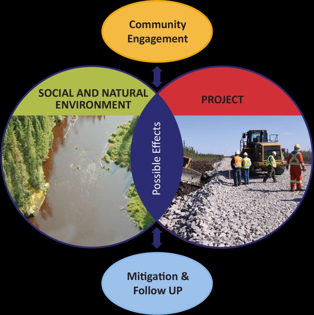
15 How to Address Possible Effects Mitigation measures are actions that can be done to avoid or reduce the effects that a project may have on the environment.
16 Potential Effects Moose


17 Potential Effects Caribou
18 Potential Effects Furbearers


19 Potential Effects Birds


20 Potential Effects Vegetation


21 Potential Effects Fish, Reptiles & Amphibians
22 Potential Effects Heritage & Cultural Sites


23 Potential Effects Traditional Resource Activities

24 Schedule


25 Table Talks! Please stay and talk with us! We want to hear and learn from you! Write on the boards Tell us what is important to you, and what should be considered Please complete a comment sheet Next Steps - We will be back to meet with you: Summer 2017: To confirm findings of the environmental assessment for the P6 Project with the community Moose Caribou

26 Thank you for your participation Contact Information: Toll-Free Fax
Project 6 All-Season Road Linking Manto Sipi Cree Nation, Bunibonibee Cree Nation & God s Lake First Nation
 Project 6 All-Season Road Linking Manto Sipi Cree Nation, Bunibonibee Cree Nation & God s Lake First Nation The Environmental Assessment - Presentation to Bunibonibee Cree Nation December 8, 2016 Why are
An Introduction to the Far North Land Use Strategy
 An Introduction to the Far North Land Use Strategy December, 2013 Ministry of Natural Resources Table of Contents PREFACE... 3 About the Far North... 3 Evolution of Land Use Planning in the Far North...
REPORT ON CONSULTATION
 PROPOSAL TO DESIGNATE THE ASATIWISIPE AKI TRADITIONAL USE PLANNING AREA AND APPROVE THE ASATIWISIPE AKI MANAGEMENT PLAN REPORT ON CONSULTATION OVERVIEW Poplar River First Nation requested the designation
Proposed St. Vital Transmission Complex
 Proposed St. Vital Transmission Complex Round 2 Preferred Route for the St. Vital to Letellier Line What is it? Manitoba Hydro is proposing construction of two 230-kilovolt (kv) transmission lines to improve
Alternative Route Selection
 Alternative Route Selection Multiple routes are developed within the Alternative Corridors Developed by Project Team taking into account all information gathered to date Buildings St. Vital Station to
Rapid Transit Implementation Working Group
 Rapid Transit Implementation Working Group October 12, 2017 1 Agenda 1. Consultation Update 2. Technical Work Update 3. LTC Rapid Transit Integration 4. Next Steps 2 Consultation Update 3 Consultation
Frequently Asked Questions Area-Based Regulation
 Frequently Asked Questions Area-Based Regulation June 2018 Q1. What is area-based regulation (ABR)? A1. ABR is a means of regulating resource development geographically. This means that any rules or practices
NORTHEAST RIVER CROSSING FUNCTIONAL PLANNING STUDY
 WELCOME Northeast River Crossing Functional Planning Study Phase 2 Public Meeting 4 to 8 PM Informal drop-in format and discussion tables Meeting Purpose Introduce the Northeast River Crossing Functional
Rapid Transit Implementation Working Group September 14, 2017
 Rapid Transit Implementation Working Group September 14, 2017 BACKGROUND Council approved the Rapid Transit Master Plan and Updated Business Case on July 25, 2017. Approval of the RTMP confirmed the BRT
Pine Flat Lake Master Plan Update FACT SHEET September 2014
 Pine Flat Lake Master Plan Update FACT SHEET September 2014 PURPOSE AND OBJECTIVE The U.S. Army Corps of Engineers Sacramento District is revising the 1976 Pine Flat Lake Master Plan and is seeking public
Blackfriars Bridge Municipal Class Environmental Assessment. Public Information Centre #1 November 19 th, 2014
 Blackfriars Bridge Municipal Class Environmental Assessment Public Information Centre #1 November 19 th, 2014 Why are you here tonight? To determine the future requirements of the river crossing at Blackfriars
Public Information Centre. Welcome
 Transportation Improvements from the Beaver Creek Bridge to the Entrance of Santa s Village District of Muskoka Municipal Class Environmental Assessment Welcome Please sign in Take a comment sheet Staff
Presentation August 20, 2013
 Presentation August 20, 2013 St. Vital Transmission Complex Stakeholder Workshop WELCOME! Manitoba Hydro 9:00am to 1:50pm Purpose of Workshop Share current project information Including outcomes of the
Alternative Routes. St. Vital to La Verendrye Station - Southern Loop Transmission Corridor. 20 different segments 4 segments common to all routes
 Alternative Routes St. Vital to La Verendrye Station - Southern Loop Transmission Corridor In a fixed right-of-way St. Vital to Letellier Station 20 different segments 4 segments common to all routes Goal
APPENDIX 1: SCOPED ENVIRONMENTAL IMPACT STATEMENT (EIS) FORM
 FORM") APPENDIX 1: SCOPED ENVIRONMENTAL IMPACT STATEMENT (EIS) FORM This form is intended for use by applicants (primarily private landowners) who need to conduct a Scoped EIS in support of minor development
APPENDIX 1: SCOPED ENVIRONMENTAL IMPACT STATEMENT (EIS) FORM This form is intended for use by applicants (primarily private landowners) who need to conduct a Scoped EIS in support of minor development
Bostwick Road. Municipal Class Environmental Assessment. October 13, City of London. Bostwick Road Municipal Class Environmental Assessment
 Bostwick Road Municipal Class Environmental Assessment October 13, 2016 Welcome! Welcome to the first Public Information Centre for the Bostwick Road Municipal Class Environmental Assessment. Representatives
Spencer Environmental 3.0 METHODS
 3.0 METHODS 3.1 General Methods Following is a summary of the main steps and activities employed in the preparation of this EISA. These were not necessarily sequential steps; many were iterative. We participated
Shell Upstream Americas Resource Use
 Resource Use Bethany Beale Sociologist, Golder Associates Ltd. David Blower Senior Archaeologist, Golder Associates Ltd. Copyright of SHELL CANADA FMFN Technical Review September-21-11 1 Fort McKay s Technical
WELCOME TO THE PUBLIC INFORMATION CENTRE. Please Sign In
 WELCOME TO THE PUBLIC INFORMATION CENTRE Replacement of Oxtongue Lake Narrows Bridge & Oxtongue River Bridge, Highway 60 (G.W.P. 93-89-00 & G.W.P. 5550-04-00) Class Environmental Assessment (Group B) Please
Northeast Anthony Henday Drive Manning Freeway to Whitemud Drive Welcome to this Construction Information Session
 Manning Freeway to Whitemud Drive Welcome to this Construction Information Session Purpose To inform interested residents and businesses about the plans accommodation. Background: The Government of Alberta
HLRD Report. Heritage, Lands & Resources Department. Why is it important to plan? November 2010
 Heritage, Lands & Resources Department HLRD Report Local Area Planning for Marsh Lake Land use plans have been completed for most areas around Whitehorse where there is development, such as the Ibex Valley
Baby Point Wastewater Pumping Station Forcemain Class Environmental Assessment Study
 Baby Point Wastewater Pumping Station Forcemain Class Environmental Assessment Study Public Drop-in Event 1 Thursday, October 12, 2017 6:00 p.m. to 8:00 p.m. Humbercrest United Church Welcome Welcome to
At the Heart of the Great Lakes
 Walpole Island Heritage Centre May 2010 At the Heart of the Great Lakes Bkejwanong: Where the Waters Divide Bkejwanong s Ecosystems OVERVIEW Walpole Island supports a rich mosaic of natural areas including
Better Cycling. The City will update the cycling master plan (London ON Bikes) based on the approved BRT network.
 based on the approved BRT network.") Better Cycling Dedicated bike facilities will be constructed along BRT corridors where space is available. Nearby bike routes will also be upgraded to ensure a complete network is available for cyclists.
Better Cycling Dedicated bike facilities will be constructed along BRT corridors where space is available. Nearby bike routes will also be upgraded to ensure a complete network is available for cyclists.
Mississauga Waterfront. Parks Strategy - Draft
 Potential configuration for river s edge seating. Boating on Credit River: A regatta Boating on Credit River: Active enjoyment 5.2 Port Credit Memorial Park West Priority Park 5.2.1 Site Opportunities
Public Open House. Yonge Street and Bernard Avenue (Bernard KDA) Planning Study Update Town of Richmond Hill. March 30, 2017
 Planning Study Update Town of Richmond Hill. March 30, 2017") Public Open House Yonge Street and Bernard Avenue (Bernard KDA) Planning Study Update Town of Richmond Hill March 30, 2017 Open House Review of Project Purpose and Process Policy Refresher Highlights of
Public Open House Yonge Street and Bernard Avenue (Bernard KDA) Planning Study Update Town of Richmond Hill March 30, 2017 Open House Review of Project Purpose and Process Policy Refresher Highlights of
WILLIAM STREET STORM SEWER OUTFALL. PUBLIC INFORMATION CENTRE March 23, 2017
 WILLIAM STREET STORM SEWER OUTFALL Municipal Class Environmental Assessment PUBLIC INFORMATION CENTRE March 23, 2017 ACCESSIBILITY Under the Accessibility Standards 2015 for Customer Service Regulation
Highway 427 Industrial Secondary Plan Area 47 Schedule C Class Environmental Assessment For Arterial Roadways
 Welcome to Pubic Information Centre #1 Highway 427 Industrial Secondary Plan Area 47 Schedule C Class Environmental Assessment For Arterial Roadways Welcome to Open House # 1 Tonight, we invite you to.
How does the Program Work?
 Is your school interested in participating in a dynamic program that supports the development of a Schoolyard Habitat program at your school in association with a local National Wildlife Refuge? If so,
SOLUT SPREAD 8. Calgary, AB, Canada T2R 0K1
 MANITOBA METIS FEDER ATION MATRIX SOLUT IONS INC. PARTNERSHIP INDIGENOUS CONSTRUCTION MONITORING WEEKLY REPORT SPREAD 8 SEPTEMBER 4 TH TO SEPTEMBER 8 TH Suite 600, 214 11 Ave. SW Calgary, AB, Canada T2R
Red Hill Valley Project More Than A Road October 16, 2006
 Red Hill Valley Project Presented By: More Than A Road October 16, 2006 September, 2007 Gerry Davis, C.M.A., Senior Director, Capital Planning and Implementation Division Public Works Department City of
2017 Canadian Consulting Engineering Awards
 2017 Canadian Consulting Engineering Awards Northeast Anthony Henday Drive DBFO Edmonton, Alberta Four years of detours, traffic snarls, varying speed limits, and stop-and-start driving has come to an
Pauingassi Community Based Land Use Plan
 Pauingassi Community Based Land Use Plan The Land of Fair Wind Pauingassi - Ontario Planning Area Pauingassi First Nation and Ontario Ministry of Natural Resources July 2011 Copies of this publication
OFFICIAL COMMUNITY PLANS (OCPs) AND ZONING BYLAWS (ZBs): PLANNING FOR THE FUTURE
 AND ZONING BYLAWS (ZBs): PLANNING FOR THE FUTURE") OFFICIAL COMMUNITY PLANS (OCPs) AND ZONING BYLAWS (ZBs): PLANNING FOR THE FUTURE Official Community Plan Workshop January 20, 2016 Frontier, SK SARM Community Planning Services SARM the voice of rural
OFFICIAL COMMUNITY PLANS (OCPs) AND ZONING BYLAWS (ZBs): PLANNING FOR THE FUTURE Official Community Plan Workshop January 20, 2016 Frontier, SK SARM Community Planning Services SARM the voice of rural
WELCOME TO OPEN HOUSE TWO November 28, 2018
 Langstaff Road Weston Road to Highway 7 Class Environmental Assessment Study WELCOME TO OPEN HOUSE TWO November 28, 2018 Please sign in and join our mailing list Study Overview York Region is conducting
Kanata Light Rail Transit Planning and Environmental Assessment Study
 Kanata Light Rail Transit Planning and Environmental Assessment Study Public Open House #2 Transportation Services Department December 7, 2017 Agenda Review study progress Confirm the Preferred Corridor
Welcome. Mill Creek Ravine Pedestrian Bridges Rehabilitation. Public Information Session #1. Thursday, October 27, :00 8:00 p.m.
 Welcome Mill Creek Ravine Pedestrian Bridges Rehabilitation Public Information Session #1 Thursday, October 27, 2016 5:00 8:00 p.m. Tonight you can: Learn about the rehabilitation of 5 pedestrian bridges
BASS PONDS, MARSH, & WETLAND HABITAT RESTORATION PROJECT
 FACT SHEET BASS PONDS, MARSH, & WETLAND HABITAT RESTORATION PROJECT MINNESOTA VALLEY NATIONAL WILDLIFE REFUGE, MINNESOTA ENVIRONMENTAL MANAGEMENT PROGRAM LOCATION Three areas located on the Minnesota Valley
Roads and Ecological Integrity. Best Management Practices. September 2016: Version 1.1
 Roads and Ecological Integrity Best Management Practices September 2016: Introduction Most of the pressures on the ecological integrity of provincial parks can be linked to, or are made worse by roads.
One River Environmental Assessment. Welcome!
 One River Environmental Assessment Welcome! One River Environmental Assessment Welcome to the One River Environmental Assessment Public Information Centre. Please explore each presentation area to learn
Alternative Routes Determined
 Alternative Routes Determined Preferred Route Selection Preferred Route Selection Expert judgment is used to determine the Final Preferred Route Takes into account feedback from Round One engagement and
Burloak Drive Grade Separation
 Burloak Drive Grade Separation Transit Project Assessment Process Public Meeting #1 March 30, 2017 GO Lakeshore West Service Plan Weekday Rush Hour 15-minute, two-way service between Aldershot* and Union
Municipal Class EA Study Public Information Centre No. 1 December 13, :00 pm 7:00 pm. Please sign in so we can keep you updated on this study
 Reconstruction of Regional Road 45 (Creek Road) Between Regional Road 27 (River Road) and Regional Road 63 (Canborough Road) in the Township of Wainfleet Municipal Class EA Study Public Information Centre
Thank you for sparing the time to visit our exhibition and to provide us with your feedback on our proposals displayed here today.
 WELCOME Aerial image of the application site in context Thank you for sparing the time to visit our exhibition and to provide us with your feedback on our proposals displayed here today. Plymouth City
138 ATTACHMENT 17. DEPARTMENT OF THE ARMY WlLMlNGTON DISTRICT, CORPS OF ENGINEERS
 138 ATTACHMENT 17 DEPARTMENT OF THE ARMY WlLMlNGTON DISTRICT, CORPS OF ENGINEERS B. EVERETT JORDAN DAM AND LAKE P.O. Box 144 MONCURE, NORTH CAROLINA 27559 April 11, 2007 Mr. Scott Radway Radway Design
M4 Corridor around Newport Environmental Statement Volume 3: Appendices
 Environmental Statement Volume 3: Appendices Environmental Statement Volume 3: Appendices At Issue March 2016 CVJV/AAR 3 rd Floor Longross Court, 47 Newport Road, Cardiff CF24 0AD Volume 3: Contents 1
ONLINE PUBLIC INFORMATION CENTRE
 ONLINE PUBLIC INFORMATION CENTRE County Road 17 Bridge Replacements Detail Design and Environmental Assessment GWP 4203-15-00 The Ministry of Transportation Ontario (MTO) has retained CH2M Hill and Dillon
Appendix B-13: Community Stakeholders Group Meeting Materials and Minutes
 Appendix B-13: Community Stakeholders Group Meeting Materials and Minutes PREPARED BY IBI Group and WSP London s Rapid Transit Initiative Community Stakeholder Group Meeting Summary Report for October
April 11, 2016 Park Board Chair and Commissioners General Manager Vancouver Board of Parks and Recreation New Brighton Salt Marsh - Preferred Concept
 TO: FROM: SUBJECT: April 11, 2016 Park Board Chair and Commissioners General Manager Vancouver Board of Parks and Recreation New Brighton Salt Marsh - Preferred Concept RECOMMENDATION A. THAT the Vancouver
Mavis Road Class Environmental Assessment
 Mavis Road Class Environmental Assessment Public Information Centre #2 Wednesday November 9, 2016 6:00 to 8:00 p.m. Please sign in and complete a comment sheet Review the displays on your own or join in
City of Loveland Natural Areas Sites
 City of Loveland Natural Areas Sites 2007 -insert full page photo- July 2008 In the Nature of Things: City of Loveland Natural Areas Sites An update to the citizens and officials of Loveland, Colorado
ENBRIDGE GAS DISTRIBUTION INC. Proposed Relocation for Ninth Line, Markham and Whitchurch-Stouffville. Environmental Screening Report
 Page 1 of 18 ENBRIDGE GAS DISTRIBUTION INC. Proposed Relocation for Ninth Line, Markham and Whitchurch-Stouffville Environmental Screening Report July 2011 Page 2 of 18 Table of Contents 1.0 INTRODUCTION
WASHINGTON COUNTY OREGON
 WASHINGTON COUNTY OREGON LONG RANGE PLANNING DIVISION North Bethany Subarea Stream Corridors: Existing Regulations In Oregon, there is a distinct difference between the land use rules that apply in rural
DEVELOPMENT PERMIT SENSITIVE ECOSYSTEMS
 DEVELOPMENT PERMIT SENSITIVE ECOSYSTEMS What is the Sensitive Ecosystem Development Permit Area (SEDPA)? Surrey s SEDPA is made up of two distinct classifications of the natural environment: Streamside
A Canadian Initiative to advance Conservation, Connections, Collaboration and Leadership for Parks and Protected Areas
 Canadian Committee for the IUCN: January 19, 2017 A Canadian Initiative to advance Conservation, Connections, Collaboration and Leadership for Parks and Protected Areas BACKGROUND Canadian Parks Council
Heritage Management Plan
 Conrad Historic Site Heritage Management Plan This Management Plan represents the best efforts of the Carcross/Tagish First Nation and Yukon Governments to meet the requirements of the Carcross/Tagish
Overall Map. Chicago. St. Louis. Summit. Joliet. Dwight. Pontiac. Bloomington-Normal Lincoln. Springfield. Carlinville. Alton EXPERIENCE IT YOURSELF.
 Overall Map Summit Chicago Bloomington-Normal Lincoln New Station Planned New Station Planned Dwight Pontiac Joliet Pedestrian overpass and second platform planned Higher speed service began in this section
New Brighton Park Shoreline Habitat Restoration Project
 Vancouver Board of Parks and Recreation and Port Metro Vancouver New Brighton Park Shoreline Habitat Restoration Project Conceptual Design Public Consultation August 26 September 9, 2015 Discussion Paper
Presentation Overview
 DETROIT RIVER INTERNATIONAL CROSSING STUDY Presentation to Windsor Rotary Club October 23, 2006 1 Presentation Overview 1. Overview 2. Progress Update Technical Work Program Environmental Work Program
First Nations Emergency and Issue Management and Fire Protection Programs
 First Nations Emergency and Issue Management and Fire Protection Programs Current and Ongoing Work October 17, 2012 Purpose Provide an overview of Aboriginal Affairs and Northern Development Canada s (AANDC)
Raystown Lake Master Plan Revision. Public Meeting April 25 & 26, 2018 How does the revision process work?
 Raystown Lake Master Plan Revision Public Meeting April 25 & 26, 2018 How does the revision process work? What is a Master Plan? The Master Plan is the strategic land use management document that guides
HAZARD MITIGATION GOALS AND OBJECTIVES
 SEWRPC Community Assistance Planning Report No. 282, 2nd Edition CITY OF MILWAUKEE ALL HAZARDS MITIGATION PLAN UPDATE Chapter IV HAZARD MITIGATION GOALS AND OBJECTIVES [NOTE: Throughout this plan update
Boeckman Road Extension
 Boeckman Road Extension Providing Safe Passage for Wildlife and Maintaining Habitat Connectivity By Kerry Rappold, City of Wilsonville Leslie Bliss-Ketchum, Portland State University October 20, 2008 Presentation
The Illinois Department of Transportation and Lake County Division of Transportation. Route 173, including the Millburn Bypass
 The Illinois Department of Transportation and Lake County Division of Transportation welcome you to this Public Hearing for U.S. Route 45 from Illinois Route 132 to Illinois Route 173, including the Millburn
A1 Scotswood to North Brunton Public Information Exhibition Executive Summary
 A1 Scotswood to North Brunton Public Information Exhibition Executive Summary Introduction The A1 Scotswood to North Brunton scheme is proposed on the A1 Newcastle Gateshead Western Bypass (NGWB) between
Outstanding Environmental Achievement
 [ A blood, sweat, and tears project becomes an Outstanding Environmental Achievement ] the story of the C.A. Chier Resource Center In the Badger Mining Corporation crest, the color green signifies BMC
Public Information Centre No. 1 King-Vaughan Road Bridge Replacement Municipal Class Environmental Assessment City of Vaughan
 Public Information Centre No. 1 King-Vaughan Road Bridge Replacement Municipal Class Environmental Assessment City of Vaughan Date: April 7, 2016 Location: Al Palladini Community Centre, Meeting Room #1
Big Picture Protected Areas Strategy Collaborating to Protect and Conserve Nature in Ontario s Carolinian Zone
 Big Picture Protected Areas Strategy Collaborating to Protect and Conserve Nature in Ontario s Carolinian Zone Jarmo Jalava Protected Areas Consultant Carolinian Canada Coalition National Workshop October
TABLE OF CONTENTS. Building Great Neighbourhoods. Working together to make the most out of your neighbourhood.
 1 What We Heard Report October 2018 City of Edmonton Building Great Neighbourhoods TABLE OF CONTENTS 1. Introduction PG 2 2. Objectives PG 2 3. Public Engagement and Communications Methods PG 3 4. About
APPENDIX I Presentations
 APPENDIX I Presentations Workshop Summary Report 11 Peel Region Official Plan Review May 5, 2010 Compatible Active Recreation Workshop July 29, 2010 Components of PROPR Sustainability Planning Tools/Updates
Strategic Framework. December 2010
 Strategic Framework December 2010 1 Further information is available at 2www.parks-parcs.ca Global Treasures Global Responsibilities As the second largest country in the world, Canada possesses rich and
Heritage Road Improvements from Steeles Avenue to Rivermont Road
 The Corporation of the City of Brampton Heritage Road Improvements from Steeles Avenue to Rivermont Road Class Environmental Assessment Study (Schedule C) September 19, 2013 The Corporation of the City
edmonton.ca/ribbonofgreen #ribbonofgreen
 WHAT IS THE RIBBON OF GREEN? The Ribbon of Green is Edmonton s entire river valley and ravine system. The Ribbon of Green (2018) Project will provide strategic guidance for the southwest and northeast
Commissioners Road West Realignment Environmental Assessment
 City of London Commissioners Road West Realignment Environmental Assessment Public Information Centre No. 2 November 29, 2017 Welcome to the Public Information Centre This 2 nd Public Information Centre
Development Reviews. An overview of the Commission s review process, primarily in Klickitat County. March 13, 2018
 Development Reviews An overview of the Commission s review process, primarily in Klickitat County March 13, 2018 Who should a landowner work with? Oregon Counties Washington Counties Multnomah County Land
Wetland Types. Grade Level: Basic. Duration: 30 minutes. Setting: Classroom
 Wetland Types Adapted from: An original Creek Connections activity created by Cassandra Hamilton. Creek Connections, Box E, Allegheny College, Meadville, PA 16335 http://creekconnections.allegheny.edu
CROFT FARM NATURE TRAIL GUIDE
 CHERRY HILL TOWNSHIP CROFT FARM NATURE TRAIL GUIDE INTRODUCTION. This nature trail is designed to help visitors open the natural world. You will increase your understanding of nature and experience its
Southwest Fleetwood Enclave
 Southwest Fleetwood Enclave Development Concept Plan Southwest Fleetwood Enclave 1 st Land Owners Meeting April 30 th, 2012 Presentation Overview Why the Plan? ; Overview & Purpose of Study; Constraints
Conserving Large Landscapes One Highway at a Time
 Conserving Large Landscapes One Highway at a Time Alex Taylor Tony Clevenger Western Transportation Institute Montana State University T Clevenger Content 1. Conserving Large Landscapes - Challenges 2.
CITY OF LONDON COVES ESA CONSERVATION MASTER PLAN COMMUNITY WORKSHOP #1
 CITY OF LONDON COVES ESA CONSERVATION MASTER PLAN COMMUNITY WORKSHOP #1 January 28 th 2014 Welcome! Purpose Reintroduce the Coves Conservation Master Plan (CMP) process; Provide an overview of Phase 1
Introduction. Public Information Package. Project website. Overview. Class Environmental Assessment Process
 1 Introduction Public Information Package Baseline Road Extension between Lambs Road and Bennett Road, Bowmanville Schedule B Municipal Class Environmental Assessment November 6, 2017 Overview The purpose
Report from the Northwest Arctic Borough Oil Spill Workshop
 Report from the Northwest Arctic Borough Oil Spill Workshop May 22-23, 2012 Kotzebue, AK Prepared by Ukallaysaaq Tom Okleasik 1 Workshop Review Organized in partnership with Coastal Response and Research
PUBLIC HEARING. Thursday, December 14, 2017 FDOT Urban Office 2198 Edison Avenue Jacksonville, FL 32204
 DISTRICT TWO PUBLIC HEARING I 10 (SR 8) from I 295 to I 95 Project Development & Environment Study Duval County, Florida Financial Project Number 213326 2 22 01 Efficient Transportation Decision Making
Conclusion Manitoba Metis Federation Metis Specific Interests Report Dec 2016 Calliou Group
 6.0 Conclusion White Birch Trees This Report considered changes to two MSIs: Lands Available for Metis Use and Harvesting. Based on the results as well as information expressed by Participants throughout
Northwest Corridor LRT Line to Irving/DFW Public Meeting No. 1 Project Overview
 LRT Line to Irving/DFW Public Meeting No. 1 Project Overview January 21, 2004 Agenda Purpose Corridor Background Environmental Impact Assessment Public Involvement Plan Project Schedule Purpose Project
Public Open House. Welcome! Presentation at 5:15 p.m. Please sign-in at the registration table
 Public Open House Welcome! Presentation at 5:15 p.m. Please sign-in at the registration table The Grand Avenue Extension Location and Environmental Study will determine the location of the extension of
South Dakota 100 Corridor Preservation
 South Dakota 100 Corridor Preservation Purpose of this Public Hearing Inform Receive Input SD100 Project Progress East Side Corridor 1993 East Side Corridor EA March 20, 2003 SD100 Corridor Preservation
Yarra Strategic Plan community engagement summary
 Yarra Strategic Plan community engagement summary Between May and August 2018 Melbourne Water undertook community engagement to build the content of the draft Yarra Strategic Plan. This engagement included
March 21, 2018 ALCA Meeting. March 21, 2018
 March 21, 2018 ALCA Meeting March 21, 2018 Agenda 1. Process and Timeline 2. Original Submission 3. Revised Submission 4. Next Steps The City of Calgary Role: The City is responsible for capturing and
TABLE OF CONTENTS Page
 TABLE OF CONTENTS Table of Contents Page 1 INTRODUCTION... 1-1 1.1 Introduction and Background... 1-1 1.1.1 Current Class Environmental Assessment Study... 1-1 1.2 Study Area (Section 1)... 1-3 1.3 Ontario
RURAL TRANSPORT TRAINING MATERIALS
 RURAL TRANSPORT TRAINING MATERIALS Module 5: Social and Environmental Issues Environmental impact assessment: Mkuze river crossing to Phelendaba, South Africa Session: 5.4 Part 2 Case Study Presentation:
DEFGH. Crystal Place Park. Environmental Impact Assessment (EIA) Elin Thomas and Emily Low Waterman Environmental
 Elin Thomas and Emily Low Waterman Environmental") DEFGH Crystal Place Park Environmental Impact Assessment (EIA) Elin Thomas and Emily Low Waterman Environmental 10.12.07 EIA Presentation Content What is EIA? Legal Requirements Process Q&A Key Topics
DEFGH Crystal Place Park Environmental Impact Assessment (EIA) Elin Thomas and Emily Low Waterman Environmental 10.12.07 EIA Presentation Content What is EIA? Legal Requirements Process Q&A Key Topics
Mine Reclamation Planning in High Elevation Caribou Range
 Mine Reclamation Planning in High Elevation Caribou Range Advancing Ecosystem Restoration Research through an Academic Partnership with Teck Resource s Quintette Mine, First Nations, and Scientists Photo
Decision Notice. Proposed Action
 Decision Notice Paving Weld County Road 105 USDA Forest Service Arapaho and Roosevelt National Forest and Pawnee National Grassland Pawnee National Grassland Ranger District Weld County, Colorado November
What We Heard Public Engagement - Stage 1
 What We Heard Public Engagement - Stage 1 Background Early planning is underway for a potential new river crossing over the North Saskatchewan River, in the northeast part of the Edmonton region. The City
Joe Pool Lake Lake Master Plan Public Information Meeting Presentation of Final Draft Revision July 31, 2018
 Joe Pool Lake Lake Master Plan Public Information Meeting Presentation of Final Draft Revision July 31, 2018 Presented By Jeremy Spencer Lake Manager U.S. Army Corps of Engineers Fort Worth District US
WELCOME TO PUBLIC INFORMATION CENTRE #2. Please Sign In
 WELCOME TO PUBLIC INFORMATION CENTRE #2 Replacement of Oxtongue Lake Narrows Bridge & Oxtongue River Bridge, Highway 60 (G.W.P. 93-89-00 & G.W.P. 5550-04-00) Class Environmental Assessment (Group B) Please
Why the workshop, why the cases?
 Green Infrastructure in Central and Eastern Europe Cases from the Czech Republic, Poland and Romania Kristijan Civic, ECNC and Agnes Zolyomi, Zolyomi, CEEweb Workshop on redesigning the landscape, connecting
Longbridge Town Centre Phase 2 Planning Application
 Longbridge Town Centre Phase 2 Planning Application Non-Technical Summary of the Environmental Statement December 2013 Introduction A full application for Planning Permission has been submitted to Birmingham
Meeting Agenda. City of Guelph. River Systems Advisory Committee. Agenda Items. Item 1, 2 and 3. Item 4 Ward to Downtown Pedestrian Bridge
 Meeting Agenda City of Guelph River Systems Advisory Committee September 19, 2018 City Hall, Meeting Room B From 4:00 to 6:00 p.m. Meeting Chair: Mariette Pushkar Agenda Items Welcome to all Item 1, 2