Town Center Vision Plan Lakewood
|
|
|
- Kristian Osborne
- 5 years ago
- Views:
Transcription

1

2 Town Center Vision Plan Lakewood City of Jacksonville Planning and Development Department Town Center Program Phase I Initiative June 2006
3 Acknowledgments This document was prepared for the City of Jacksonville Planning and Development Department. It was developed through input from dozens of local participants. The development process spanned the summer of We are grateful to the many community members who participated in the neighborhood workshops and contributed their time, energy, and vision to this report. A special recognition is due JaxPride, a nonprofit coalition for visual enhancement, for their early and ongoing community visioning activities in Jacksonville. Their volunteer efforts have helped raise community awareness about the importance of having a Vision for neighborhood improvement. John Peyton Mayor City of Jacksonville Art Shad District 5 Representative Jacksonville City Council Jeannie Fewell Director Planning and Development Department Kenneth Logsdon, AICP Town Center Program Manager Planning and Development Department i Thanks is also extended to the Lakewood Presbyterian Church for graciously hosting the public workshop. Sponsoring Organizations The Lakewood Community, Inc. Nancy L. Mueller, President Sutton Park Drive South Suite 200 Jacksonville, Florida fax Project Consultant This document was prepared by: Prosser Hallock, Inc.
4 Contents 1. Overview Community Vision Focusing the Vision Expanding the Vision Implementing the Vision Maintaining the Vision Final Recommendations Conclusion ii 9. Appendix... 41

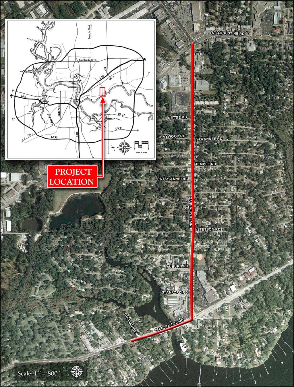
5 1 Overview What is a town center? The phrase conjures an image of Main Street, of activity and livelihood, of a space that is historic, active, interesting, and inviting. A Town Center can take several forms. It may be an urbanized area, condensed and pedestrian oriented, with commercial enterprises that serve the local community and other amenities such as parks and plazas. Alternatively, it may be a commercial corridor that links several neighborhoods together, serving both vehicles and pedestrians. Because they serve as community hubs, Town Centers should be attractive and well maintained. This report represents an effort by the Lakewood community to redefine their Town Center with assistance from the City of Jacksonville. To be part of the City s Town Center Program, a Town Center must be at least 30 years old and must have been at one time an established commercial district or corridor at the heart of an existing community or neighborhood. The central Lakewood business district is a prime example of a Town Center that continues to support the local community. Despite the aesthetic decline associated with the widening of University Boulevard, the community recognizes the importance of this area as a valuable neighborhood resource. This Vision Plan is an effort to restore and improve this Town Center through a community-based initiative and with the help and resources of the City of Jacksonville. Background The City of Jacksonville, through the leadership of City Council member Suzanne Jenkins, developed the Town Center Program as a means of providing support to local organizations for redeveloping areas of town that have served the community and that still retain some character, historically, aesthetically, or otherwise. The City also recognizes the role these Town Centers can serve as Jacksonville grows: to provide shopping, service, and entertainment alternatives, support small and local businesses, and create meaningful and memorable places that define the City s cultural and economic identity. Older communities want their commercial corridors that are the front doors to their neighborhood to reflect the character of their community It s about the community first coming together because the plan has to be put together by the community not done to them or for them, but done with them. - Suzanne Jenkins, Jacksonville City Council In January of 2005, The Lakewood Community (TLC, Inc.) received a grant from the City of Jacksonville for Phase I Visioning as part of the Town Center Program. Specifically, this Phase I effort creates a Vision for redeveloping the Town Center located along University Boulevard, from San Jose Boulevard east to St. Augustine Road. Once a Phase I Vision is completed, organizations 1
6 are eligible to apply for Phase II funding (Design and Engineering). Phase I recipients, however, are not guaranteed Phase II funding through the program. If Phase II is successfully completed, Phase III (Construction) funds are granted to apply toward implementation. The Town Center Program is administered by the City of Jacksonville Planning and Development Department. concluded the workshop by prioritizing projects based on desirability and estimated cost. This input, detailed in the next section, allowed the Team to develop plans for Phase II and Phase III implementations, as presented in this report. Mission The mission of this project is to develop a Vision for Lakewood that satisfies the needs and desires of the local community while incorporating the realities of cost, conditions, and other constraints. A neighborhood workshop was conducted on August 9, 2005 to gather community ideas and opinions. This Vision Plan report is a direct result of that input. INITIAL PROGRAMMING GOALS & OBJECTIVES Planning Process To generate a Vision, the City formed a Project Team composed of staff from the Planning and Development Department, as well as professional planners, landscape architects, and engineers from Prosser Hallock, Inc. The Team developed a streamlined process to encourage as much public participation and input as possible. Team leaders initiated the process by meeting with TLC representatives to identify key issues in the area. The Project Team then conducted a series of site visits to walk the area, discuss opportunities and constraints, and record information. SITE VISITS and DATA A COLLECTION PUBLIC WORKSHOPS VISION DEVELOPMENT DRAFT REPORT 2 After preliminary analysis and information gathering, the Team conducted a public workshop that was carefully organized to allow direct input of the participants at both a personal and communal level. Participants CITY & ORGANIZA GANIZATION REVIEW FINAL VISION PLAN
7 Plan Area The Lakewood Town Center is the corridor along University Boulevard from San Jose Boulevard east to St. Augustine Road. It is comprised of commercial uses at the east and west ends of the corridor with a mix of residential and civic uses in between. A map depicting the plan area is shown on the following page. Area History Walter R. Crabtree ( ), a real estate developer and builder in Duval County, developed the entire Lakewood area between 1946 and 1961, some of it around picturesque New Ross Creek that meanders through the northwest section. He conveyed the land for what would become Crabtree Park to Duval County in several deeds between 1957 and For over fifty years, he operated his own lumber company and built the Lakewood Apartments across from the park. 3
8 4

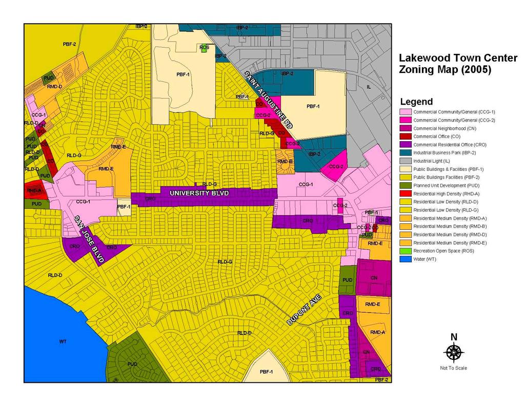
9 2 Community Vision At the heart of this Visioning process are the comments, concerns, and dreams of the area residents. These are the people who know the Lakewood community the best, who live and work in the area, who use the roads and sidewalks, who work to improve local conditions, and who enjoy the use of the neighborhood businesses and community facilities. A realistic Vision for redevelopment and revitalization of this area must include their input. Therefore, the Project Team developed a careful program to gather as much direct input as possible within a short time frame. Background Data Prior to the first workshop on August 9th, 2005, the Team conducted a site visit and analysis to confirm significant existing conditions that would likely influence Town Center planning. The following section includes a demographic profile A view of Lake Maria Sanchez from the bridge on San Jose Blvd. of the community, while a background data summary and zoning map are provided at the end of this section. The Florida Department of Transportation maintains jurisdiction over the Town Center project limits University Boulevard was recently resurfaced and restriped as part of a larger resurfacing project which will be extended to I- 95 and from Beach Boulevard to the Arlington Expressway. Community Profile The following community profile is based on an analysis of census tracts 163 (block group 3), 164 (block group 3), and 165 (block group 1), as well as local zoning information. These boundaries are all immediately adjacent to the University Boulevard corridor between San Jose Boulevard and St Augustine Road. This sample provides a profile of the community proximate to the Town Center. Note: Census data is from 1990 & The total population has increased approximately 2% from 1990 to 2000 (3,105 in 1990 to 3,173 in 2000) The median age has increased from 39.8 in 1990 to 40.2 in While changes in the Census 2000 reporting methods have made direct racial comparisons with previous censuses difficult, the total minority population has increased from 5.1% in 1990 to 10.2% in The percentage of high school graduates increased from 85.9% in 1990 to 92.6% in 2000, while the rate of individuals attaining a bachelor s degree or higher increased from 29.4% to 39.5% over the same period. In constant dollars, median household income increased from $32,837 in 1989 to $39,375 in Accounting for inflation, however, 5
 in 1989 to $75,000 in 1999. The median year for structures built is 1957.")
10 median household income actually declined approximately $4,700 over the same period. Median home values have dropped 1.5% when accounting for inflation, from $76,205 (based on consumer price index) in 1989 to $75,000 in The median year for structures built is The vast majority (95%) of the immediate study area is commercial, characterized by CRO and CCG-1 zoning, while the remaining parcels are public buildings and facilities (Crabtree Park) and medium density residential. Census Conclusions The data from the Lakewood neighborhood as a whole, suggests a relatively stable and healthy middle class community. Despite this, quality of life issues pertaining to pedestrian safety and commercial revitalization need to be addressed. The widening of University Boulevard, while efficient in terms of moving traffic, has had a negative impact on the community s character. The census data indicates that median home values and household income has declined slightly during the reported period, however there is great potential to improve the image and pedestrian safety of the area using the Town Center program as a vehicle for renewal. Combining this effort with the affordability, historic character, and proximity of Lakewood to neighborhoods such as San Marco, San Jose, and Downtown should make the area more attractive as Jacksonville continues to grow. Community Vision Workshop Community contributions are the heart of this Visioning effort. The Town Center Program was initiated not only to provide a physical improvement of Jacksonville neighborhoods, but also to help bring the people of each community together and encourage renewed interest, activity, relationships, and organization. A cross-section of 19 area residents and business owners attended the public workshop held on August 9, 2005 at the Lakewood Presbyterian Church. The workshop was carefully organized to garner as much input and participation as possible from attendees. The project Team utilized a simple and streamlined approach that enabled small groups to formulate their own creative ideas for improving the community. To supplement the community workshop, surveys were administered to gather demographic information and to ask property owners and workshop participants to consider two important questions: Where are we now? and Where would we like to be? Participants reflected on these questions in a personal way to try to identify important issues, concerns, and visions for the future that would not be influenced or overshadowed in the open discussion to follow. The following is a brief summary of their responses to these questions. These answers and those collected from the open discussion were synthesized to create a master list of prioritized items used to guide the overall Vision concept. 6
11 Who are we? The following questions were asked in the survey. Of the approximately 19 participants at the first workshop, 11 completed the surveys. Your age? Under 15: 0% 15-24: 0% 25-40: 18% 41-60: 18% Over 60: 64% Are you married? Yes: 90% No: 10% Do you have school age children? Yes: 90% No: 10% What neighborhood do you live in? Lakewood: 100% How long have you lived there? Less than 5 years: 0% 5 to 15 years: 18% Over 15 years: 82% Is your home within walking distance of the Town Center? Yes: 73% No: 27% How often do you visit the Town Center? Once a week or more: 100% Monthly: 0% Less than once per month: 0% Do you own a business or work in the Town Center area? Own business: 10% Work: 0% Neither: 90% Where do you typically go for dinner and entertainment? San Marco, Gene s, Ted s Italian, Atlanta Bread, Mojo BBQ, Stonewood, Downtown, Beaches Where are we now? To evaluate each participant s perspective on current conditions affecting the University Boulevard corridor, the survey included a section that asked Where are we now? Participants were asked to consider how they feel about their Town Center today and to list their top three concerns. This question created a reference point on which to base the emerging Vision. Some of the top survey responses are listed below: Lakewood today is a great area to live, but needs more landscaping and medians to slow down the traffic is very impersonal, no real sense of community has too much pavement and too little greenspace is unsafe for pedestrians and schoolchildren the houses which are now businesses/offices are trashy and unattractive Where would we like to be? Participants were also asked in the survey to answer the question Where would we like to be? They were instructed to share the top three changes they would like to see in their Town 7

12 Center in the future. The intent of the survey questions was to gather an unbiased and personal vision from each individual. Again, some of the primary responses are listed below: Lakewood in the future needs to become a pedestrian oriented district-not car oriented A more neighborhood feel improved lighting and landscaping along University Boulevard improved shopping with more upscale stores an attractive entrance sign to identify the community The survey responses indicate an older neighborhood in need of maintenance but with a strong motivation for improving its condition, whether to protect property values, preserve resident safety and quality of life, revitalize commercial properties, or create a desirable, noteworthy community. While residents, business owners, and workshop participants recognize the issues in their community, they remain optimistic about its future, recognizing the potential of Lakewood to serve as a vital commercial asset to the community. Group Planning Following the workshop introductions and surveys, the Project Team directed participants into small groups to begin the process of examining their community and formulating ideas and strategies for improvement. The Team provided plan sheets, aerial photographs, zoning maps, as well as pens, markers, scales, tape, tracing paper, and other tools needed to translate group ideas into images. Team members were on hand to help in the translation process, with the goal of developing a graphic vision that represented group concerns or ideas. After capturing their initial ideas, each group presented their plan or Vision concept to the overall group and responded to questions and comments. Project Team members recorded group ideas by table: Group 1 Use Michigan Avenue in Chicago as an example Place numerous medians along the corridor Reduce University Blvd. to two lanes with landscaping on each side and a landscaped median in between Improve sidewalks with brick pavers Improve lighting and aesthetics with decorative ornamental light fixtures Provide bus shelters at bus stops along corridor Provide street furniture, such as benches and trash receptacles Place a crosswalk at Stanford Road and every bus stop and fix existing broken crosswalk signals Group 2 Keep University Blvd. four lanes, but reduce each lane width to 10 feet Eliminate turn lanes at most intersections Provide eight foot lanes (for parking and bikes) on both sides with bump outs from Nettie to Auburn Rd., landscaping, and decorative lighting Plant trees along the corridor Add crosswalks, especially at Crabtree Park and from the apartments to the Winn Dixie shopping plaza Provide signature bus shelters along the corridor 8

.")
13 Place an entry monument/sign at San Jose and University, San Jose and Cornell, or both Improve light synchronization at San Jose Improve bridge as a public space or create a public park next to the creek Group Prioritizing Once the groups presented their Vision plans, the Team prepared two master list of projects. The first list are those items eligible for Town Center funding. The second list contains projects that are not eligible for Town Center funding but will be used to create long term goals for the community. Projects not eligible for funding through the Town Center Program will require funding from other sources identified in this report (See Section 5). Group 3 Reduce University to two lanes with a center turn lane for bike/pedestrian provisions Install crosswalk at Stanford and University Minimize cut through traffic on Cornell 9 Install traffic calming device on Stanford Provide a crosswalk at Crabtree Park, in light of recent park improvements Provide street and pedestrian lighting Facade improvements for businesses along University Blvd. Locate entry sign/monument/public art at both University at Nettie and University at San Jose Stronger code enforcement and facade improvements Workshop participants were then asked to vote on the listed items. This process establishes a prioritization of projects. Details such as timeline and budget were factored in when determining the priority of each project. Participants prioritized the master lists by voting with colored adhesive dots. Each participant was given three dots for each list to place next to the projects they desired most. They could use all three on one project or spread them among their top three choices. Once everyone had placed their dots, the most popular projects were visible to the group. The results were discussed for clarification and group concensus. Prioritized Master Lists Town Center Fundable Projects 1. Reduce University Blvd. to two lanes with a median.
14 2. Remove turn lane on University Blvd. between Auburn and Nettie Rd. for a parking and bike lane. 3. Place monument/entry signage at University and San Jose and at Cornell Rd. 4 Install crosswalks at Stanford Rd., Auburn Rd., and at select bus stops. 5. Enhance bridge at New Rose Creek to create a more vibrant public space. 6. Add ornamental lighting along University Blvd. 7. Improve area bus stops with new benches and trash receptacles. 8. Redesign the turn lane from San Jose on to University to slow traffic and make more pedestrian friendly. 9. Adjust the signal timing at the crosswalk of San Jose and University Blvd. Outside Town Center Scope 1. Provide better pedestrian lighting within the residential portions of the Lakewood community Provide upgrades to Crabtree Park to include new amenities and parking. 3. Improve existing businesses along University Blvd. via facade improvements, landscaping, and lighting. 4. Install speed bumps/humps along Cornell Rd. From this exercise, the Project Team identified a staging approach that echoed participant desires. The resulting program, described fully in the next section, is a logical sequence that allows for projects important to the community to be designed and built within the funding framework of the Town Center Program.
15 Project Background Summary The following summary provides general information about the project area considered in establishing the Vision: Project Limits: University Boulevard between: San Jose Boulevard and St. Augustine Road Planning District(s): 3 City Council District(s): 5 City Council District Representative(s): Art Shad Length of Corridor: 1.10 miles Corridor Right-of-Way Jurisdiction: FDOT Width of Right of Way: 80 feet Curb to Curb Width of Roadway: 63 feet Major Cross Streets: San Jose Boulevard (Signalized) Stetson Road (Unsignalized) Graywood Road (Signalized) St. Augustine Road (Signalized) Roadway Classification: Minor Arterial Posted Speed Limit: 40 mph Number of Lanes: 5 (4 travel lanes with central turn lane) Lane Width: 11 feet Zoning (number of property parcels): CCG-1 (23) CRO (56) RMD-E (2) CCG-2 (1) PBF-1 (1) Total Number of Study Area Property Parcels: 83 Maximum PM Peak Hour Capacity: 3270 Percent of Total Capacity Used: 46% Total Capacity Available: Level of Service: C Average Daily Trips (2004): 16,000 Number of Bus Stops: 14 Electrical Service Location: Overhead Historic Buildings and Sites: None Churches along Corridor: Lakewood Presbyterian Church Government Buildings along Corridor: None Public Parks along Corridor: Crabtree Park Typical Sidewalk Material: Concrete Typical Width of Sidewalks: 5 feet Typical Street Light Type: Cobra Head Typical Street Light Spacing: 150 feet 11
16 12
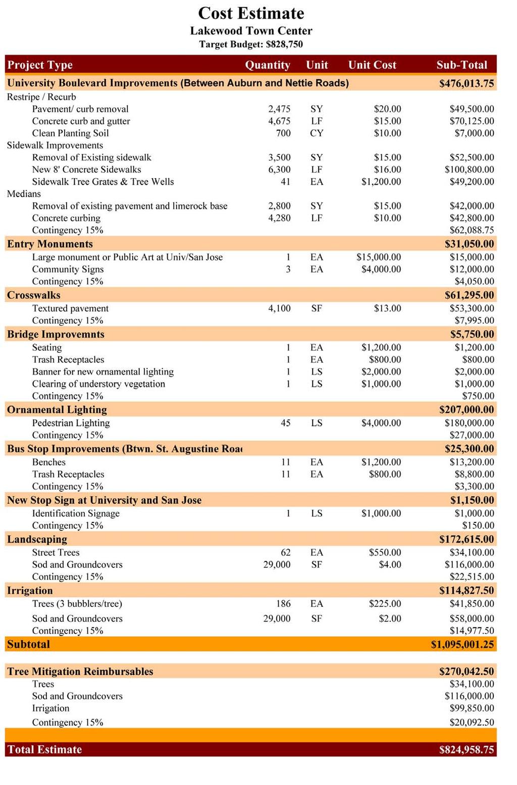
17 3 Focusing the Vision Working within the Town Center Program This section describes the projects selected by the community that support their Vision and that could be funded through the Town Center Program. While funding is not assured, as Phase II and Phase III projects require separate applications, the projects listed in this section meet Town Center funding requirements. Section 4, Expanding the Vision, describes other projects supported by the community as part of the long range Vision that are not eligible for Town Center funding or that are not suitable as a Town Center funded project due to their projected budget or complexity. nature of this report, the primary purpose of the cost estimate is to allow the community to prioritize projects based on cost in relation to desirability. This gives the projects an added dimension of reality. The projects in this section are listed in order of priority according to the community s responses during the workshops and their understanding of projected costs. This order is intended to guide future decisions in the event full funding is not available, or if the program must be separated into different design or construction phases. Not all of the projects envisioned by the community can be installed within the limited budget of the Town Center Program. Therefore, this section represents an effort to prioritize those projects supported by the community that can utilize Town Center funds for design and implementation. With community input, the Project Team has attempted to distribute potential funding among the projects to achieve the maximum visual and functional impact for the given dollars. The following program has been developed with the assumption that full Town Center funds would be available for design and implementation in the near future. It has also been developed with the understanding that certain projects might also be eligible for funding through other programs, such as the City of Jacksonville s Tree Mitigation Trust Fund (see Section 5, Other Funding Opportunities ). The cost estimate found at the end of this section lists the proposed projects and an estimated cost for installation. While reasonably accurate given the conceptual Right-of-Way Improvements Town Center funds are limited to improvements within the right-of-way, therefore the community and Project Team focused most of their efforts on improvements to that space. Projects outside the right-of-way that are part of the community Vision are described in Section 4. The Florida Department of Transportation (FDOT) maintains jurisdiction over University Boulevard and San Jose Boulevard right-of-ways within the Lakewood Town Center project limits. Proposed improvements and associated maintenance within the right-of-way are subject to FDOT s final approval. The recommended improvements in this section are typically agreeable to FDOT, the City of Jacksonville, and other governing bodies, provided they meet established design guidelines and that provisions are made regarding additional maintenance requirements. 13

18 While Phase II of the Town Center Program will deal with final design and permitting issues, the Project Team has attempted, even at this conceptual level, to avoid design approaches that could become contentious or problematic. Section 6 of this report, Maintaining the Vision, addresses maintenance issues for the proposed improvements. The maintenance recommendations may assist in determining final design guidelines and, ultimately, to build an acceptable partnership with the City for ongoing maintenance. The projects described in this section were identified as first priority projects that would qualify for Phase II and Phase III funding under the Town Center Program, if funding for those phases are awarded to Lakewood. These rightof-way improvements that were selected and prioritized by the workshop participants are projects that would make a significant, positive impact to the corridor. Some of these improvements encourage private property enhancements that respond to participant visions for renewal. Improve Safety and Pedestrian Space on University Boulevard Create more pedestrian space and restripe pavement to reduce lane width to narrow road and slow traffic. Workshop particants were overwhelmingly concerned with the lack of safe pedestrian space along University Boulevard. The four-laning of University Boulevard has provided limited space for sidewalks, bike lanes, lighting and landscape features within its 80-foot ROW. Unfortunately this creates an unsafe walking and/or bicycling environment, due to the little to no buffer between the speeding traffic and the pedestrian. These primary concerns were at the heart of the two most preferred design solutions presented by the workshop participants. After exploring the community s desires, the design team concluded with a compromise that would be faithful to the resident s concerns, while still being a workable solution to the City and the FDOT. The following paragraphs outline the two options explored by the workshop participants. 14 Existing right-of-way conditions on University Boulevard in Lakewood. Most importantly, these improvements are highly visible and fit within the available funding parameters. Other viable projects identified as part of the Vision that fall outside the funding parameters of the Town Center Program are described in Section 4. Workshop participants most preferred the option included reducing University Boulevard to two travel lanes separated with a large landscaped median. The reduction of lanes would increase pedestrian space, allowing for landscape elements, ornamental lighting, wider sidewalks and an overall safer space for pedestrian traffic. Large landscaped medians not only provide aesthetic enhancements, but aid in narrowing the road, reducing vehicular traffic, thereby increasing pedestrian safety. This option would reduce the traffic volume signigicantly; however, preliminary discussions with the FDOT revealed that it is unlikely that they would allow a 50% decrease in travel lanes after recently increasing the number of lanes. In furtherance, implementation cost for this option would be out of reach of the alloted Town Center funds at this time.

19 The second most preferred option proposed by the workshop participants involved the removal of the center turn lane between Auburn and Nettie Roads. These roads were selected because the space between these segments represent the heart of the Lakewood residential community, while both ends of University Boulevard are more commercial in nature. As conceptualized, this option would enable the construction of bumpouts, mass transit buses, additional room for landscaping and lighting, and a combination parking/bike lane to enhance the walkability within this segment of the community. The project team studied this alternative, and determined that there would be an increase in rearend vehicular crashes, as the fifth lane provides a refuge for left turning vehicles. Additionally, while not intended for this purpose, center lanes provide an intermittent harbor, or safe zone, for illegal pedestrian crossings at undesignated spaces. Restripe and Recurb Reduce lane width, restripe and recurb the entire length of University Boulevard in order to increase pedestrian space. Since Town Center resources are limited, improvements will be concentrated between Auburn and Nettie Roads. This segment of University Boulevard was identified as more community oriented due to the number of intesecting local, neighborhood roads. It is recommended that additional space for pedestrian and landscape elements be obtained via restriping/recurbing University Boulevard to create four 11-foot travel lanes and a 12-foot center turn lane. This will provide additional space for a wider buffer between the existing sidewalk and the roadway, thus creating more room for street trees and pedestrian lights. The effect of reducing the travel lane s width also allows the development of landscape medians, thus slowing traffic and creating a safer environment. It is within the Auburn and Nettie Road segment that the elimination or reduction of curb cuts should be considered on University Boulevard. The number and frequency of curb cuts increases the number of vehicles entering the roadway, creating a greater safety hazard. Removal of curb cuts by extending curbs and gutters and replacing sidewalks allows vehicular access to be more controlled, thereby enhancing pedestrian safety. Some businesses located on corners have the opportunity to utilize side street driveways versus University Boulevard and are encouraged to do so, where possible. Sidewalk replacement Remove existing sidewalks between Nettie and Auburn Roads and install new 8 -sidewalks. Workshop participants expressed the desire to improve pedestrian movement on Unversity Boulevard. Existing sidewalks are narrow and many utility conficts exist. Cost prevents the replacement of all sidewalks along the entire University Boulevard corridor. As a result, it is recommended to remove and replace existing sidewalks between Auburn and Nettie Roads for this initial enhancement phase. Additional enhancements should be completed for the remainder of the Utility pole interrupts the sidewalk on University Blvd. Boulevard during future phases when funds are available. Street Trees Install new street trees along University Boulevard on both sides of the roadway where space allows. Workshop participants expressed the need for landscaping within the project area. Street trees will create a more comfortable walking environment and provide an additional traffic calming element along the corridor. In addition, street trees will greatly improve the corridors aesthetic appearance, mitigate objectionable commercial storefronts and parking lots, thereby further 15


20 reinforcing a unified appearance. This unification is created by spacing trees evenly along the corridor between the road and sidewalk. This creates a visual rhythm along the roadway that also provides protection for pedestrians, as illustrated in the following graphic. Lastly, trees add environmental value to the corridor by increasing shade, filtering dust and pollutants, and providing habitat for birds and other animals. Street trees should be planted at 40 feet on center as space and FDOT sightline requirements allow. The plan below illustrates the positioning of trees in relationship to the sidewalk and curb. Back of Curb 4 Minimum Center of Tree Tree Grate Right-of-Way 8 Concrete Sidewalk Groundcover Travel Lane Example of utilizing a tree grate in the sidewalk. determined in the next phase of the Town Center Program. An estimated 41 street trees, placed approximately 75 feet on-center on alternating sides of the street are proposed for University Boulevard. The diagram at the end of this section graphically identifies the areas street trees will be allowed. Landscaped Medians Create new landscaped medians where space permits. The incorporation of landscaped medians assist in reinforcing the visual narrowing of University Boulevard, providing traffic calming for the corridor. Although they contribute to the beautification of the corridor, they also provide a more accessible and safer link between the neighborhoods on either side of the Boulevard by providing a pedestrian refuge or safe zone, at designated intersections. 16 Although space is limited, trees are required to be installed 4 feet from the back of curb, the minimum distance allowable by the FDOT. This placement positions the trees within the sidewalk, thus requiring tree grates to be used for all of the proposed trees between the Auburn Road and Nettie Road segment. Overhead utilites provide additional restrictions on street tree selection and placement. An upright cultivar of the Drake Elm (Ulmus parvifolia) is recommended for the space. Exact location, spacing, and species choice will be Landscaped median


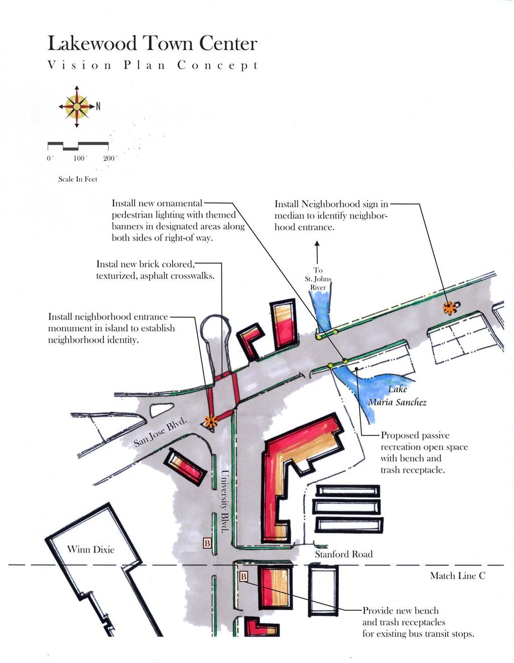
21 All proposed medians are illustrated on the Vision Plan Concept at the end of this chapter. Due to budget and required FDOT site line constraints only four medians are factored into this phase of the Town Center program. These medians are the most suitable due to crosswalk locations as well as overall traffic flow. They are also selected because they reinforce the visual narrowing of University Boulevard between Nettie and Auburn Roads. The remaining medians should be planned for future phases when funds become available. The site on the corner of University and San Jose Boulevards is a large and highly visible space in comparison to the other two. It is also set apart from the others as it is surrounded by commercial activity. This site is best suited for a vertical monument or a selected piece of public art. Three of the medians are proposed to be planted with trees such as Live Oaks (Quercus virginiana) or the Drake Elms (Ulmus parvifolia). To reduce maintenance cost and effort, a groundcover such as Japanese Star Jasmine (Trachelospermum asiaticum) should be planted within the median spaces versus using grass in the medians. Exact location and species of landscape features will be determined during the construction phase of the Town Center Program. A total of 21 trees are estimated for use in the landscaped medians. Entry Monuments Install new entry monuments at primary entrances to Lakewood. Workshop participants expressed a strong desire to better identify the Lakewood community through the use of entry features. Three locations were proposed at the workshop. The first location is at the southeast corner of the University Boulevard and San Jose Boulevard intersection. The second is within the median space on San Jose at the Cornell Road crossing. This location is more visible to those entering the town center from the north on San Jose Boulevard. The third location is in the proposed median at Nettie Road and would be visible to those entering from the east on University Boulevard. The three locations are highlighted on the master plan at the end of this section. Suggested site for monument location at University and San Jose Boulevards The median location on San Jose reflects the residential character of Lakewood. Further, the proposed median near Nettie Road is the westbound introduction to the Lakewood community. A sign at this location will help to identify the corridor as a neighborhood, hopefully having the effect of slowing traffic. Both spaces are smaller than the commercial location, making them more suitable for a smaller, horizontally oriented sign which is lower to the ground. Masonry or metal construction are the recommended materials for all features. These materials are durable and readily available. Brick, stacked stone, or stucco veneers are appropriate Suggested site for sign location on San Jose Blvd at Cornell Rd. 17

22 masonry materials that would blend with the local architecture. Each sign could also include information such as a new community logo and dates established. The monuments should be externally lighted for night visibility. Final design and construction material selection should take into consideration the aesthetic character of the community. Crosswalks Install new crosswalks at primary intersections and bus stops Workshop participants identified the need for more visible and functional pedestrian crosswalks within the project area. Intersection crosswalks are proposed for Phase I, as illustrated on the Vision Plan Concept at the end of this chapter. New crosswalks should be at least 8 feet wide and constructed with a durable and decorative treatment. Crosswalks provide better visual definition of intersections and heighten awareness that a pedestrian zone is ahead. The use of colored and textured road pavers, or other ornamental paving material, is recommended to enhance the location of the pedestrian zone, calm traffic, and increase safety. The location of intersection crosswalks is often subject to possible constraints, such as existing power poles and storm inlets; however Brick paver crosswalk in LaVilla their length should be minimized as much as possible. Specific crosswalk surface treatment such as color and pattern will be determined during Phase II development. Workshop participants specifically desired crosswalk locations at Stanford Road, Auburn Road, Stetson Road and Colgate Road, at all bus stops, and at the Albertson s shopping center. The availability of Town Center funds limits the number of crosswalks recommended. It is recommended that pedestrian crosswalks be constructed at all three lighted intersections, so they can be easilty identified. The recommended locations for new, decorative crosswalks are shown in the graphic diagram at the end of this section. Bridge improvements Enhance bridge at New Rose Creek to create a more vibrant public space. To announce the arrival into the Lakewood Town Center, workshop participants expressed the need for enhancements to the bridge at New Rose Creek. In addition to the potential aesthetic appeal of the bridge improvements, the site offers a unique opportunity to create additional public open space as you are entering and exiting the Town Center for pedestrians and passersby to enjoy the natural surroundings. Currently, the New Rose Creek Bridge is not well identified. The lack of elevation change or any identifiable sign or marker makes the bridge easy to pass without notice. Expansive views to the St. Johns River have been narrowed by neighborhood encroachment and visually obstructed by understory vegetation in some areas. The site would benefit from enhancements that would help to identify the natural feature the bridge crosses. The installation of pedestrian scaled lighting will help to highlight this area as well as provide a safety feature to those using the area in the evenings. Banners are proposed to be hung from these light fixtures to further accentuate New Rose Creek and the Lakewood Town Center. The design team observed steady pedestrian traffic on the east sidewalk. Many residents from the neighborhood were walking with their 18


23 children or their dogs. This further reinforces the potential benefits of a passive open space in the area. Existing conditions at the Rose Creek Bridge A small parcel exists on the east side of the bridge. It affords potentially expansive views westerly to the St. Johns River and to Lake Maria Snachez to the east. It makes an ideal resting place for residents using the sidewalks for passive recreation. The parcel, indicated in red in the graphic below, is owned by the City of Jacksonville and is controlled by the Streets and Drainage Department. Coordination with the City would be necessary before improvements could be made on this site. Additional coordination with the City s Parks and Recreation Division will be necessary for the oversight and maintenance of the site. Proposed improvements include providing a seating area, oriented to take advantage of the views. Money should be allocated to the clearing of the understory to open views. The addition of colorful plant material, such as Florida wildflowers, would accentuate the bridge and views, thereby improving the user s experience. Wildflowers are low maintenance and can be mowed during designated times of the year. Final design of the site will be determined in phase two of the Town Center Program. The sketch on the next page illustrates some of the ideas generated by the design team. 19 Views from potential public open space.

24 The community must also consider collision liability, if they assume responsibility for the fixtures. For these reasons, JEA standard lighting fixtures are recommended for the University Boulevard corridor. View of Lake Maria Snachez from Northeast corner of New Rose Creek bridge Ornamental Lighting Install new ornamental lighting along University Boulevard. Workshop participants indicated the desire to install new, decorative light fixtures within the Town Center district to provide supplemental lighting, to improve safety, and establish an identity for the community. The proposed light fixtures should be pedestrian-scaled only. They are not intended to replace existing street lights due to the fact that they do not provide the illumination requirements for vehicular traffic. These pedestrian-scale ornamental lights should be installed at each intersection throughout the narrowed area between Auburn and Nettie Roads, where possible. Their application is intended to establish a community identity, heightened aesthetic appearance and to improve area lighting and safety. A 12 to 16-foot height is appropriate and would focus attention at a lower level, creating a safer and walkable pedestrian community. The fixture type selected should provide a unifying theme complimentary to the corridor s character. It is very important to consider maintenance of the fixtures selected. If a fixture is selected that is not a JEA standard, then the community must assume maintenance of those fixtures, including replacement of dead bulbs and damaged poles. Selective use of pedestrianscale decorative fixtures JEA teardrop fixture would provide the corridor with a renewed spirit and unique identity within the City. Due to budget constraints, it would not be possible or pragmatic to distribute ornamental fixtures throughout the entire project area. Therefore, the proposed locations between Auburn and Nettie Roads provide the best visual impact and most effective distribution of Town Center funding. Final selection of fixture type and specific locations will be determined during the development of construction documents. As a result, the following locations and quantities are offered for guidance and estimating purposes. Approximate locations for these fixtures are illustrated in the diagram at the end of this section. An estimated 30 new posts and fixtures will be required within the narrowing area between Auburn and Nettie Roads. Additionally, four lights are proposed to be located at each corner of the New Rose Creek Bridge. Bus Stop Improvements Improve area bus stops with new benches and trash receptacles. All existing benches and trash receptacles between St. Augustine Road and San Jose Boulevard should be removed and new ones installed at each bus stop where space allows. A cost for eleven benches and trash receptacles is provided in the cost estimate. Specific street furniture types, colors, and locations will be identified during the Phase II design process. The addition of street furniture will help to 20
25 improve the overall image of the corridor and provide a more pedestrian street environment. Per the proposed Town Center Plan at the end of this section, an additional 11 trash receptacles should be placed within the corridor as space and budget allows. Traffic Calming Strategies Modify existing yield at San Jose Blvd./University Blvd. intersection. One of the major concerns of the workshop participants is the lack of pedestrian safety at the intersection of San Jose and University Boulevard. The dedicated right hand yield at the northbound approach onto University Boulevard creates a dangerous scenario for pedestrians crossing the intersection. Despite the pedestrian island, vehicles are continually observed speeding through the yield sign onto University Boulevard and disregarding pedestrians. It is recommended that a stop sign replace the existing yield to allow traffic to recognize the potential for pedestrians utilizing the intersection. This will create a safer environment for those walking and also slow traffic down within the commercial area. If Lakewood is to become a more livable and walkable community, then vehicular/pedestrian conflict must be minimized and traffic calming features implemented. Irrigation Supplemental irrigation for the plants specified in this report is recommended but not critical to their success. The recommended plant species are hardy and well suited to the harsh urban environments typical of this corridor. Once established, ordinarily a one-year process, these plants will live without supplemental irrigation, but not flourish as well as they would with irrigation. Nonetheless, workshop participants expressed a desire to irrigate landscape improvements as part of the overall vision. The cost estimate provides a broad estimate for an automated irrigation system for the plants recommended in this section. The Department of Public Works will provide final requirements, designs, and feasibility of irrigation systems as a part of Phases II and III. In every circumstance, maintenance responsibility for an automated irrigation system must be resolved prior to development of Phase II design, construction plans. Cost Estimate The Project Team prepared a cost estimate for the projects described in this section. It is based upon current construction trends and material and labor costs. It is also based on the proposed conceptual plan and utilizes current construction trends and material/labor costs. Dimensions and takeoffs are averages and based upon some assumptions. This estimate must be accepted as such and not be interpreted as absolute. A more accurate budget will be developed during the Phase II construction plan development. An effort has been made to give the sponsoring association the widest range of options in Phase II by providing the costs for individual components of a project. A note on methodology: The initial project phase was broken into its major components and calculated with fixed unit costs representative of current construction averages. Unit costs include labor and installation hardware. Quantities were taken from the plan shown at the end of this section. All totals include a 15 percent contingency to allow for non-included and unforeseen costs, such as mobilization, permitting, and buried hazards. 21
26 22
27 Match Line A Minuteman Lane B University Blvd. B Provide new bench and trash receptacles at existing bus transit stops between St. Augustine Road & San Jose Blvd. Albertson s B 23 Reduce curbcuts along corridor for access, management and improved safety. B Install new brick-colored, texturized, asphalt crosswalks. St. Augustine Rd Lakewood Town Center V i s i o n P l a n C o n c e p t Scale In Feet N

28 University Blvd. Match Line B B Colgate Road B Install new brick- colored, texturized, asphalt crosswalks. Patsy Anne Drive Remove unnecessary curbcuts along corridor for access management and improved safety. Install in new medians to visually narrow the corridor and to provide traffic calming. Temple Road Orangewood Road Reduce lane widths to 11.5 ft. wide, restripe and recurb the length of University Blvd. between Auburn and Nettie Roads to increase pedestrian walkability and safety. Install new ornamental pedestrian lighting with themed banners in designated areas along both sides of right-of-way. 24 Provide new bench and trash receptacles for existing bus transit stops between St. Augustine Road and San Jose Blvd. Install neighborhood sign in median. Suwannee Road B B Graywood Road Install street trees and cast iron tree grates in new sidewalks in designated areas along both sides of right-of-way Scale In Feet N Nettie Road Lakewood Town Center V i s i o n P l a n C o n c e p t Match Line A

29
30 26 26

31 Lakewood University Boulevard Roadway Section Between Nettie and Auburn Roads 27 Scale: 1 =25
32 4 Expanding the Vision Non-Town Center Program Projects The following projects and improvements are listed outside of the primary group of projects because of their dependency on outside elements, budget constraints, or unknown variables to reach completion. They are important projects that were identified and discussed in the workshops, and they should continue to be considered for coordination, funding, design, and implementation. If political and financial support are found for some, or all, of these projects, they could be designed and installed at the same time as the primary projects described in Section 3. Alternative and supplemental funding options are listed in Section 5 to give the Lakewood community additional funding sources. Neighborhood Lighting Improvements Provide better pedestrian lighting within the residential areas of Lakewood. The majority of the workshop participants felt that in addition to the use of ornamental lighting along the University Blvd. corridor, supplementary pedestrian lighting should be utilized within the residential areas to the north of University Blvd. Residents felt that the area is too dark at night and additional lighting would provide safety for pedestrians looking to walk to the town center or simply taking a stroll or jog in the evening hours. The use of ornamental lighting would also provide aesthetic enhancement to complement the natural setting of the neighborhood. Although this activity is outside the Town Center boundary, it is recommmended that TLC coordinate with JEA to provide additional lighting in the public right of way in the residential portions of Lakewood. Signal Timing at San Jose and University Blvd. Adjust the pedestrian signal timing to increase the duration allowed to cross the intersection. Workshop participants were overwhelmingly concerned with the lack of pedestrian safety at the intersection of University and San Jose Blvd. Of specific concern was the short phase time provided by the pedestrian signal for those wishing to cross University Blvd. at San Jose. Typically the pedestrian signal phase is designed for normal adult walking speeds through an intersection from the beginning of the WALK signal through the end of the flashing DON T WALK signal. However, given that the majority of the pedestrians crossing at this location are elderly and children, it is recommended that the signal timing be adjusted to account for their walking speeds and safety. Despite the presence of the pedestrian refuge between the intersection and the east bound turning lane off San Jose, there is still too little time provided for most pedestrians to safely cross the street. Fortunately, this problem can be addressed without cost. It is recommended that TLC contact the City s Traffic Engineering Division to schedule a site visit and make a formal determination of action. A traffic engineer will test the intersection in a variety of pedestrian modes in order to determine if ad- 28
33 equate timing is provided. If it is determined that the majority of users require additional time, the signal will be adjusted accordingly. Crabtree Park Improvements Provide additional upgrades to enhance the neighborhood park. To build upon the potential Town Center improvements, workshop participants expressed the desire to provide additional upgrades and amenities to Crabtree Park, which is the only neighborhood park in the area. In the Spring of 2002, the City Parks and Recreation Department erected a new pavilion and modified the adjacent sidewalks for ADA (American Disabilities Act) compliance. However, residents felt that Lakewood would further benefit from additional park improvements to create a major neighborhood focal point. Recommended improvements may include court resurfacing/restriping, resodding and redesigning the playing field, providing a new playset for kids, and most importantly, providing expanded parking facilities to allow those who drive from outside the neighborhood to use the park. In order to realize this vision, TLC should coordinate with the Division of Planning, Research, and Grants in Parks and Recreation to identify park needs and pursue additional funding opportunities and implementation strategies. Traffic Calming Strategy for Cornell Rd. Install traffic speed bumps to reduce speeding in the area neighborhood. Workshop participants placed speed bumps as a high priority in terms of reducing cut-through traffic and speeding within the residential portions of Lakewood, especially along Cornell Road. This project represents a drastic measure in terms of minimizing speeding, but residents emphasized the importance pedestrian safety for the area. Implementation of speed bumps would require further study through the Public Works Department to determine their real need and specific design and location. Many of the items discussed in Section 3 are anticipated to provide suitable traffic calming measures, which may eliminate the need for speed bumps. It is recommended that TLC wait until Phase III implementation is complete. If traffic rates and speeding are not reduced after that effort, then TLC should proceed with coordinating speed bumps through the Public Works Department. Private Property Building Improvements Improve overall corridor image by encouraging private building improvements. In addition to projects within the right-of-way, but outside the Town Center funding parameters, opportunities exist for private property owners to make improvements that would complement the recommended projects. Buildings are one of the primary elements defining the Town Center corridor. Their architectural style, history, arrangement, and use create a sense of place more than any other single corridor feature. Buildings older than 40 or 50 years (from the date of this report) were built in an era when raw materials, especially lumber, were of a much higher quality. Craftsmanship had a higher social value at that time, and attention to form and detail was important. Location of these buildings is also significant; they typically were built with storefronts facing the primary road and close to the right-of-way. This placement is in contrast with development trends that evolved with the automobile and shifted priorities toward parking convenience, resulting in buildings being pushed toward the rear of lots. The placement of buildings close to the road is a visually defining element that forms a desirable pedestrian space. Buildings from the older era are visually apparent and an immediate indicator of a historic place. 29
34 Older buildings are usually worth preserving and renovating. Preservation and renovation can be tedious and expensive, which is why old buildings are often forsaken for new construction. In addition, current building codes are written with new development in mind and can complicate or limit the process of renovation. Still, if a viable Town Center is sought, these difficulties must be overcome through encouragement programs that ease financial and permitting burdens. The following recommendations are among the most important for creating an appealing Town Center: Restoration of storefront windows. Traditional storefront windows should be preserved and alteration with metal frames or excessive paint should be avoided. Do not paint exposed brick. Many of the storefronts along the corridor are unpainted brick. They should remain unpainted to preserve the original appearance. Painting of brick is most often irreversible and should be avoided whenever possible. Dilapidated buildings should be demolished. Dumpsters and trash containers should be screened from public view. The use of plant materials and/or wood or concrete/brick fencing should be utilized to screen all dumpster and trash containers. Screening violations can be reported to code enforcement through the City s C.A.R.E. system. Provide parking lot buffers. To promote pedestrian safety and general aesthetics, parking lot buffers should be required where business property lines meet public sidewalks and adjacent roadways. Landscaped buffers can be formally addressed through the adoption of a local zoning overlay district. This is discussed in detail in Section 7. the front of storefronts. As mentioned previously, however, this is an expensive process when not coupled with other infrastructure improvements, costing roughly $1 million per mile. JEA, as the electrical utility provider, has indicated in word and practice a desire to locate their wires underground, and this is their general preference with new development. Burying existing wires in an older neighborhood, however, presents major challenges. The technology exists to jack and bore the wires underground without disturbing the surface, but it is a costly procedure. Additionally, other service providers that share the overhead lines with JEA (telephone and cable) must also agree with this direction for it to occur. It is not clear who would be responsible for paying for this service; no one party feels they should assume the full cost. In other areas of town, JEA has participated in burying their overhead lines when major road or utility work has occurred. Repair or replacement of existing underground utilities, like storm sewers or water lines, are prime examples of projects that require major roadway construction ideal for relocating utilities underground. As stated before, the most likely scenario for procuring underground corridor utilities would be during the planning stage of the next major roadway construction. Placing utilities underground is a very effective way to improve aesthetic conditions along roadways and is included as part of the long-term vision for the University Boulevard corridor. 30 Overhead Utilities Workshop participants unanimously agreed that locating overhead utilities underground would improve the aesthetics of the corridor. Aging utility poles could be removed, sidewalk space expanded, ugly wires buried from sight and off
35 5 Implementing the Vision The previous two sections describe many projects that make up the overall Vision for Lakewood. At least some of those Vision elements could be realized within a relatively short time, probably 2 to 4 years from the date of this report. Nevertheless, these projects alone are not enough to ensure that Lakewood will grow into the energetic, pedestrian-oriented community envisioned by the workshop participants. Several implementation measures remain to be considered by TLC and the community. Fortunately, a model exists that provides an established framework on which the community could base their own Town Center initiative. The Florida Main Street Approach The Town Center corridor that is the heart of Lakewood functions similarly to a small town Main Street. The Florida Main Street program provides a useful model for developing implementation strategies. Florida Main Street is a program of the Department of State, Division of Historical Resources, Bureau of Historic Preservation. The program provides training and technical assistance to local Florida Main Street programs in accordance with the National Main Street Center Four Point Approach and with assistance from the National Main Street Center. Design improvements alone will not bring about meaningful change; effective marketing, a strong organizational base and solid economic development strategies are all necessary to reverse the cycle of decay from which many downtowns suffer and to sustain preservation activity. (Florida Main Street) Organization Organization means building consensus and cooperation among the groups that play roles in downtown. Many individuals have a stake in the economic viability of the downtown, including: bankers, property owners, city and county officials, merchants, downtown residents, professionals, chamber of commerce representatives, local industries, civic groups, historic societies, schools, consumers, real estate agents, and local media. (Florida Main Street) Form a Steering Committee. Organization is at the heart of Main Street success. Main Street programs always have a dedicated manager and often this is a full-time paid position. TLC, Inc. the Phase I sponsor, is already a dedicated organization. To ensure that needs specific to this Vision are met however, a Town Center steering committee should be formed that is dedicated to overseeing its implementation. The steering committee would be responsible for enacting the design, promotion and economic restructuring points of the program. Form a Local Merchants Organization. Because local business owners are part of this process and can benefit greatly from its success, the Project Team also recommends that a local merchants group be formed that can represent its significant interests. Design Design involves improving the downtown s image by enhancing its physical appearance not just the appearance of buildings, but also that of street lights, window displays, parking areas, signs, sidewalks, promotional materials and all other elements that convey a visual message about the downtown and what it has to offer. (Florida Main Street) 31
36 Develop a Logo. TLC should commission a design competition or hire a professional graphic designer to create a new logo for the University Boulevard corridor. The logo should be simple and recognizable, ideally incorporating some visual element of the corridor that best embodies the Town Center. The logo should be used on banners or lighting fixtures and by the community associations on all marketing materials. While initially useful for promoting the Town Center, a successful logo also will help strengthen the entire community s identity. Develop a Handout. TLC should design a handout dedicated to the Lakewood Town Center that outlines Vision goals and progress to date and solicits involvement and input. This handout could be distributed by members of the community associations, as well as local merchants and offices. Form a Subcommittee Dedicated to Future Programming. Projects listed in Section 4 are not funded under the City s Town Center Program. A Town Center subcommittee should be formed to be responsible for coordination with Parks and Recreation, City Council representatives, the Planning and Development Department, area business representatives, and other stakeholders affected by the proposed projects. Additionally, this subcommittee should identify alternative funding sources to create more development implementation options. Promotion Promotion involves marketing the area s unique characteristics to shoppers, investors, new businesses, residents, tourists, and others. Effective promotion creates a positive image for the area through retail promotional activity, special events and ongoing programs to build a positive image of the community. Involve Local Merchants. To gain the support necessary to enact this Vision, the program and Lakewood itself must be actively promoted. The local merchants need to be a part of this promotion effort and involved in its organization. It is important that promotion planners understand merchant needs such as access and visibility, and it is just as important for business owners to understand that promotion often involves extra effort, such as extending store hours at certain times. Create a New Event. Regular events are an excellent means of generating interest and activity for a Town Center. We recommend that TLC create at least one new event that is unique to the area that would attract local residents as well as people from around the City. Dade City Main Street used a two-event-per-year program to effectively build support for Main Street and at the same time create new local traditions. They created one event to be family-oriented, inexpensive, and fun (a Halloween carnival) and one event that was purely for the merchants (a Christmas walk). Both events require a great deal of organization but have resulted in a very successful redevelopment for their Town Center. Economic Restructuring Economic restructuring means strengthening the existing economic base of the downtown while diversifying it. Economic restructuring activities include helping existing downtown businesses expand, recruiting new businesses to provide a balanced mix, converting unused space into productive property and sharpening the competitiveness of downtown merchants. By strengthening the downtown s economy, communities are able to support the ongoing use of historic commercial buildings, preserving unique community assets. (Florida Main Street) sions. Conduct a Market Study. A market study would examine in detail the economic and demographic conditions specific to Venetia. Initial efforts might include identifying sources of funding to pay for a professional analysis. Alternatively, TLC could conduct their own market study (using volunteers to research available 32
37 data) and draw conclusions regarding the current and potential conditions of the environment. In either case, this would be a significant first effort toward economic restructuring, lending the necessary information to make informed decisions. Town Center Program Phase II TLC, as the Phase I sponsor, is the logical choice to pursue the necessary funding resources to implement the design. The types of improvements found in Section 3 of this report and their estimated costs can serve as the guide that identifies the funding required to implement the Town Center Vision. Phase II would involve providing the funds necessary to continue development of the Vision, generally resulting in construction plans and a final cost estimate. Additional community input to refine the plan is also a part of this phase. Phase II will require continued coordination by TLC, and the community with area stakeholders, District Council representatives, the City, and other affected agencies such as JEA and JTA. Other Funding Opportunities Several funding opportunities could be used by TLC (or other viable party) to help implement the Future Projects described earlier in Sections 3 and 4. The following list and contact information is meant to be a starting point. Numerous other opportunities exist and may provide the best fit for implementing one or more of these projects. City of Jacksonville The following City programs are accessible but often competitive, requiring the sponsoring agent to be organized and persistent as recommended earlier. Nevertheless, the projects outlined in this report as community building initiatives are ideal candidates for utilizing funding from many of these sources. The following list is meant to be a starting point as other opportunities exist and may provide a better fit for implementing one or more of these projects. Small Business Development Initiative Program This program is aimed at small and start-up businesses and provides low interest loans to qualified applicants for up to 30% of the project cost, and not to exceed $250,000. Mayor s Neighborhood Matching Grants Program The Mayor s Neighborhood Matching Grants (MNMG) Program makes awards of up to $5,000 to specific neighborhood projects that build relationships and enhance the community. As part of the city s continuing efforts to improve and strengthen Jacksonville neighborhoods, the Mayor has proposed for City Council approval an appropriation of $308,800 for the Fiscal Year budget cycle. If authorized, the funds will become available October 1, Any neighborhood association, civic organization or community group that has been in existence for at least six months and is located in Duval County is eligible to submit an application. ( The Matching Grant Program offers neighborhood organizations the opportunity to initiate and implement smaller scale projects and manage the projects themselves. This program may offer opportunities to develop some of the smaller projects identified in this report or pieces of larger ones. For more information about the program, contact Glory Dixon at or by at gdixon@coj.net. Community Development Block Grant The Community Development Block Grant (CDBG) is an entitlement grant awarded to the City of Jacksonville through the U.S. Department of Housing and Urban Development (U.S. HUD) that is based upon need factors including population, income, unemployment level and housing conditions. 33
38 CDBG grants are to be used for a wide range of housing and community development activities directed toward neighborhood revitalization, economic development and improved community facilities and services, and must give maximum feasible priority to activities that will benefit low-and moderate-income persons or aid in the prevention or elimination of slums or blight. Funds may also be used to meet other community development needs that present a serious and immediate threat to the health or welfare of the community. ( Use of CDBG funds is limited to those census tracts defined as low- to moderate-income. These tracts have at least 51% of residents classified as low- to moderate-income, defined by U.S. HUD as having household incomes ranging from 30% to 80% of the local median income. The area south of Merrill Road contains census tracts meeting this criterion. Some of the projects outlined in this report in this area could be eligible for CDBG funding. Local information about the program can be obtained at or on-line at Historic Properties In November 1992, the State of Florida authorized local governments to provide a partial tax exemption on historic properties. The City of Jacksonville approved an ad valorem tax exemption for locally designated properties that undergo a substantial rehabilitation. ( To be eligible for Historic Property benefits, the property or area must have a historic designation. Properties can seek landmark status at the local level or apply for a listing on the National Register of Historic Properties through the Trust for Historic Preservation. Lakewood is not part of an established historic district; therefore, each building or property would apply individually. Tree Protection and Related Expenses Trust Fund The Jacksonville City Council approved the creation of the Tree Protection and Related Expenses Trust Fund to provide for the replacement of removed protected trees within the public right-of-way and for their establishment and care. Contributions to the fund come primarily from property owners, both private and public, that remove protected trees (as defined by the ordinance) and elect to pay for each protected tree removed (at $107 per caliper inch at the time of this report), rather than replace them with new trees according to the ordinance requirements. The proposed trees in this report are located in the right-of-way and may be eligible for funding through the Tree Protection and Related Expenses Trust Fund. The proposed project cost estimate provided on page 22, has included utilizing this Trust Fund in determining the final cost projections. State of Florida The following resources and contact information are listed for potential state funding and assistance. They are listed in order of applicability to this Vision report and those with greatest correlation are described more fully. Florida Department of Transportation The current Transportation Enhancement Program (TEP) provides enhancement funds for improvements that are recommended in this report as well as other improvements not specifically addressed, such as provisions for bike lanes. TEA-21 Enhancement Program Transportation enhancement projects, including bike and pedestrian trails. Robert Crimm (850) Suwannee Street Tallahassee, Florida The Transportation Enhancement Program (TEP) is a federal program administered by the Florida Department of Transportation (FDOT). TEP guidance and direction are provided by the Environmental Management Office, whereas the selection and implementation of most enhancement projects are handled by the FDOT District Offices with input from Metropolitan Planning Organizations or County Commissions. Funding for transportation enhancement projects is provided by the Federal Highway Administration 34
39 (FHWA) through the Federal Transportation Equity Act for the 21st Century (TEA-21). This funding is intended for projects or features that go beyond what has been customarily provided with transportation improvements. This program is for projects that are related to the transportation system but are beyond what is required through normal mitigation or routinely provided features is transportation improvements. TEP is not a grant program, rather projects are undertaken by project sponsors, and eligible costs are reimbursed. TEP Activities Defined - 1. Provision of facilities for pedestrians and bicycles. 2. Provision of safety and educational activities for pedestrians and bicyclists. 3. Acquisition of scenic easements and scenic or historic sites. 4. Scenic or historic highway programs (including the provision of tourist and welcome center facilities). 5. Landscaping and other scenic beautification. 6. Historic preservation. 7. Rehabilitation and operation of historic transportation buildings, structures, or facilities (including historic railroad facilities and canals). 8. Preservation of abandoned railway corridors (including the conversion and use thereof for pedestrian or bicycle trails). 9. Control and removal of outdoor advertising. 10. Archaeological planning and research. 11. Environmental mitigation to address water pollution due to highway runoff or reduce vehicle-caused wildlife mortality while maintaining habitat connectivity. 12. Establishment of transportation museums. ( Department of Community Affairs Florida Communities Trust This program could provide another funding mechanism for acquiring land for proposed parks. Florida Communities Trust (FCT) is a state land acquisition grant program housed at the Florida Department of Community Affairs. FCT provides funding to local governments and eligible nonprofit environmental organizations for acquisition of community-based parks, open space and greenways that further outdoor recreation and natural resource protection needs identified in local government comprehensive plans. ( Janice Browning (850) Shumard Oak Boulevard Tallahassee, Florida State Historic Preservation Grants-in-Aid Program (Department of State) Historic and archaeological site identification, preservation, restoration and education. Fred Gaske (850) South Bronough Street Tallahassee, Florida Historical Museums Grants-In-Aid Program (Department of State) Development of exhibits on Florida history. David Gregory (850) The Old Capitol, Room B South Monroe Street Tallahassee, Florida Cultural Facilities Program (Department of State) Funding for acquisition, construction and renovation of cultural facilities. Don Blancett (850) DeSoto Park Tallahassee, Florida Challenge Grant Program (Department of State) Funding to support unique or innovative cultural projects. Dr. Gaylen Phillips (850) DeSoto Park Tallahassee, Florida

40 6 Maintaining the Vision Maintenance is a significant issue determining the success or failure of proposed improvements, whether on public or private land. Maintenance represents care, and the care of a place is visually apparent even from a fast moving car. The degree of care offered to a place, whether building or landscape, is usually a factor of time and money, but it also depends greatly on varying attitudes about what is visually acceptable by a community. With regard to public right-of-ways and parks, the immediate solution for elevated maintenance is the creation of partnerships. Partnerships between public and private entities many times allow for a win-win situation, with each often getting what they want. Public agencies aim to please the community while maintaining a budget; private entities desire a higher degree of control over the look and upkeep of their shared environment. In many partnerships, all or a percentage of the public maintenance budget is allotted to the private entity for maintenance purposes under a contract clearly stating minimum requirements. In some cases, the established public budget is adequate to fund the desired maintenance when supplemented with volunteer labor, donations, and other resources not available to the public entity. The broad design measures recommended in this report are prepared with the benefit of training and expertise. The use of certain materials and their arrangement will create a more ordered and appealing environment, even with little continual maintenance. Where a more manicured appearance is desired, supplemental maintenance will be required. The recommendations below are aimed at providing the necessary coordination and practice to achieve a higher quality appearance and longer lasting product for the proposed corridor improvements. Partnerships Roadside maintenance in Deerwood, a public/private partnership The FDOT is the public agency that maintains jurisdiction over the right-of-way along this segment of University Boulevard. To move this Vision forward, TLC must coordinate the implementation goals of this plan with the City. To achieve a consistency in maintenance along the entire corridor, a contract may be required between all public agencies, the residents, and the businesses. Landscaping Plant materials are one of the most visible clues to the degree of maintenance an area or place undertakes. Basic landscape maintenance is relatively inexpensive when compared to the cost of roadway, infrastructure, utility, building, or other maintenance efforts. Typical landscape routines for public sector entities are limited to regular mowing with occasional edging and trimming. This Town Center plan proposes to remove the existing grass. 36
41 Extended Maintenance Period The critical maintenance period for landscape plants is the first year following installation. Typical FDOT and City of Jacksonville landscape contracts require a 90-day maintenance period. This is not long enough to ensure proper plant establishment. The duration of maintenance through establishment is further necessitated when there is no automated irrigation system and this plan has been developed to not be contingent upon such a system. Therefore, installation contracts should include an extended maintenance program for a minimum of one year to allow better establishment of new plants. General Maintenance Practices General maintenance practices should conform to industry standards. While the plants recommended in this report are hardy and should do well with little attention once established, they will grow faster, be healthier, and look much better with regular attendance. Plants should be fertilized annually, according to their specific need. Plants should be inspected annually for pests or disease, and pesticides should be applied as needed to infested or diseased plants. Pruning should be accomplished only by licensed personnel and according to American National Standards Institute (ANSI A-300) pruning specifications. Pruning should only be performed to remove dead or low-hanging branches. Crape myrtles especially should not be cut back severely from the top but instead allowed to achieve a natural, small tree form. Weeds should be removed at least twice per year during establishment, and after shrubs and ground covers have been established, on an as needed basis. To limit weed intrusion, an annual application of mulch and pre-emergent herbicide is recommended for all planting beds. Pine straw and pine bark are recommended mulch selections. Cypress bark should be avoided as a nonrenewable resource and artificially colored mulches avoided due to their unnatural appearance. Sidewalks, Crosswalks, and Seating Areas Paved areas outside of the roadway itself need to be inspected annually for cracking, settlement, and other conditions that pose a hazard to pedestrians. Weeds that appear in cracks and spaces should be spot-treated as needed and diligently with an herbicide. Light Posts and Signal Posts Light and signal posts should be inspected annually and damage reported to JEA. Repainting should occur when fading or peeling is visible. Buildings Older buildings such as the ones along the Town Center corridor require continual maintenance. Facade treatments, storefronts and street-facing, publicly visible features are of concern in this report. Exposed wood materials should be kept painted, stained, or treated to maintain the quality of the wood and a well-kept appearance. Jacksonville s climatic conditions necessitate repainting on a five-year average. Faded or torn awnings, or other cloth or plastic material mounted to the facade, should be replaced with new material. Property owners should keep sidewalks that are their responsibility in good repair and clean of all litter and debris to maintain a well-kept appearance. Graffiti should be removed immediately from sidewalks or building walls. Graffiti that lingers signals to visitors and vandals that the neighborhood takes little interest in their community s well-being, while prompt removal is indicative of neighborhood pride and proactive concern. Products are available for this purpose, and standard oven cleaner apparently works well. 37
42 7 Final Recommendations As a final measure of ensuring the ongoing realization of the Lakewood Town Center Vision, some recommendations are offered to address other issues discussed by the group. Overlay District During the workshop, participants discussed the value of improving the design standards for all or part of the University Boulevard corridor. An overlay district would allow University Boulevard property owners to develop written guidelines specific to the neighborhood and geared toward protection and promotion of its valuable assets. Guidelines would give greater understanding, form, and direction to renovation and development efforts. Establishment of a district could also give an added measure of protection to older properties. Primary areas of concern discussed in the workshops: commercial signage, building renovations, and parking enhancements. Commercial Signs Signs along the corridor including commercial signs and transportation signs have significant visual impact. Because transportation signs must maintain universality for effectiveness, the commercial signs along the corridor should be the primary focus. As part of the overlay guidelines, TLC should develop sign guidelines that are specific to University Boulevard. The development of a consistent signage program with specific guidelines will aid new businesses attracted to the town center. Guidelines also will aid existing business owners in communicating the long-term objectives of the program and, while not obligating them to change or replace their current signs, will at least inform them of the Vision. Sign attributes such as size, location, height, color, shape, and material should be considered. Architectural Guidelines As with sign guidelines, TLC should create architectural guidelines for the overlay district, specific to the needs and Vision of the Lakewood Town Center. Such guidelines would assist business owners in providing renovation standards, while boosting investor confidence in the strength of local commitment to the Town Center Program. As the most visible and public aspect of commercial buildings, architectural guidelines should initially address facade improvements. General guidelines for facade improvements are offered in Sections 4 and 6, but additional measures specific to the district should be developed. CPTED CPTED is the acronym for Crime Prevention Through Environmental Design. CPTED is defined as the proper design and effective use of the built environment that can lead to a reduction in the fear and incidence of crime and an improvement in the quality of life. CPTED addresses crime problems through controlling the environment. CPTED is based on these three overlapping strategies: 1. Natural Surveillance - The placement and design or physical features to maximize visibility. This includes building orientation, windows, entrances and exits, parking lots, walkways, guard gates, landscape trees and shrubs, fences or walls, signage and any other physical obstruction. 38
43 2. Natural Access Control - The use of sidewalks, pavement, lighting and landscaping to clearly guide the public to and from entrances and exits. Also, the use of fences, walls or landscaping to prevent and/or discourage public access to or from dark and/or unmonitored areas. 3. Territorial Reinforcement - The use of pavement treatments, landscaping, art, signage, screening and fences to define and outline ownership or property. Program Goals The goal of CPTED is to reduce opportunities for crime that may be inherent in the design of structures or in the design of neighborhoods. The goal is accomplished through the involvement of CPTED trained law enforcement officers in the planning, development, and design review of community projects. How does CPTED impact me? CPTED impacts each citizen by increasing safety, promoting secure environments and improving the appearance of neighborhoods and public amenities. CPTED improves existing services by working with neighborhoods, businesses, community groups and law enforcement. ( Called septed, this City of Jacksonville s Sheriff s Office (JSO) program from the JSO helps communities identify crime-causing elements in the environment and solutions to rectify them. JSO has designated officers specially trained to communicate this process to the community and to find solutions specific to the area. Many of their observations are intriguing and escape notice by the layperson. Often it is little changes to the environment that make big differences in reducing crime. As this is a free service, we strongly recommend that UPCA and CPCA coordinate a CPTED survey through the JSO. Officer Laurie Dill, (904) JSO Community Affairs Division 501 East Bay Street, Room 204 Jacksonville, Florida Code Enforcement Workshop participants cited greater code enforcement as a very high priority to ensure a cleaner and more appealing corridor. Significant problems noted by participants included: Private property maintenance, especially concerning deteriorating buildings and yard maintenance Trash removal from the right-of-way Cars parked in front yards of offices and residences Poor signage and fencing issues Crime The Jacksonville Ordinance Code provides for minimum acceptable social practices to maintain a consistent appearance and a pleasant, healthy living environment. Citizens may register complaints and violations directly with the City through City Link and the C.A.R.E. system. City Link 17 W. Duval Street Suite M-150, City Hall Jacksonville, FL (904)630-CITY JaxPride, a Coalition for Visual Enhancement, is another resource available for assisting with local code enforcement through their Neighborhood Inventory of Visual Pollution (NIVP) program. This program provides assistance to local communities for identifying code violations in their neighborhood that cause visual blight. The program has been very successful in helping inform and empower concerned citizens, as well as improving the visual quality of the city. JaxPride jaxpride@fcol.com 39

44 8 Conclusion The Lakewood commercial district has a viable opportunity through the City s Town Center Initiative to restore and revitalize its character, provide better, safer shopping, service, and entertainment alternatives for area residents, and create a more meaningful and aesthetically pleasing environment. This report represents the first step in affecting those changes. The Vision for Lakewood, as conceived in this plan through data collection, community input, Vision concepts, and implementation recommendations, is a fundamental requirement for moving forward. This report meets Town Center Program Phase II funding requirements and contains the necessary ingredients to steer development of construction drawings. Phase I recipients, however, are not guaranteed Phase II funding through the program. If funding is made available by the City for Phase II, the Phase II design consultant should use this report to identify the primary themes and recommendations developed for University Boulevard. The Vision Plan illustrations provided in this report are intended to be a guide for developing construction drawings. They should be utilized by the Phase II consultant until more accurate survey and base information is developed. Where changes must occur due to unforeseen circumstances, the Phase II consultant should make needed adjustments while keeping the theme of the Vision in mind. TLC has taken a strong first step in pursuing this program to create a revitalized Lakewood Town Center. This Vision plan is an outgrowth of that effort and responds directly to the needs and desires of the community. Through the fulfillment of this Vision, the Lakewood community will become more attractive, safe, prosperous, and recognized as a unique and desirable place within the greater city of Jacksonville. 40 View from proposed public space to Lake Maria Sanchez
3 Focusing the Vision Following the second workshop, the Project
 3 Focusing the Vision Following the second workshop, the Project Team undertook the task of refining the Vision developed during the workshops. The final plan addresses participant desires while incorporating
City of Farmington. Downtown Plan. Amendment to the 1998 Master Plan Adopted October 11, 2004
 City of Farmington Amendment to the 1998 Master Plan Adopted October 11, 2004 Introduction Planning Background 1 Scope and Components of the Plan Amendment 2 Concept Introduction 3 Plan Concepts 3 Conceptual
Table of Contents. Elm Avenue Improvement Plan City of Waco, Texas. Introduction 1. Existing Context 1 Figure 1 2.
 Table of Contents Introduction 1 Existing Context 1 Figure 1 2 Plan Guidelines 3 Future Urban Form 4 The West-End 4 Main Street 6 The East-End 7 Figure 2 9 Public Improvement Recommendations 7 General
COMPLETE GREEN STREET CHECKLIST
 COMPLETE GREEN STREET CHECKLIST This document was developed to dissect the structure of an urban street and explore opportunities to make our streets more complete while also integrating green street strategies.
The Lower SaLuda Greenway
 The Lower SaLuda Greenway InITIaTIve a FLourIShInG Greenway. a hub For economic GrowTh. a ConneCTIon BeTween CoMMunITIeS. In April 2017 the Michael J. Mungo Foundation and Lexington County commissioned
Community Design Plan
 Gardena General Plan 2006 Authority While the is not a required element of a General Plan, it is included because improving the community appearance and image is paramount to the overall quality of life
GREENING THE BOULEVARD Master Plan Concepts for Venice Boulevard between Lincoln and Sawtelle
 GREENING THE BOULEVARD Katherine Spitz Associates Inc. 4212½ Glencoe Avenue Marina Del Rey, CA 90292 310 574 4460 Fax 574 4462 January 2008 Table of Contents Overview Proposed Design Improvements Illustration
SDOT DPD. SDOT Director s Rule DPD Director s Rule DCLU DR SED DR of 7 CITY OF SEATTLE
 SDOT SDOT Director s Rule 2-07 DPD Applicant: CITY OF SEATTLE Page 1 of 7 Supersedes: DCLU DR 11-93 SED DR 93-4 Seattle Department of Transportation (SDOT) Department of Planning and Development (DPD)
VEHICULAR AND PEDESTRIAN CIRCULATION
 This perspective sketch communicates the intended character and quality of a proposed streetscape design. Locate benches near a major intersection where people tend to gather. Seating and lighting provide
Town Center Vision Plan Myrtle and Moncrief
 Town Center Vision Plan Myrtle and Moncrief City of Jacksonville Planning and Development Department Town Center Program Phase I Initiative May 2004 Acknowledgments This document was prepared for the City
4.1.3 LAND USE CATEGORIES
 4.1.3 LAND USE CATEGORIES a. City Center District The City Center District incorporates the existing character and mix of uses in downtown Belmont to encourage redevelopment and new development in keeping
Denton. A. Downtown Task Force
 2 Public Involvement Early and ongoing public involvement was solicited so that the public had ample opportunity to help direct the DTIP s concepts and implementation strategies. The residents of Denton
Policies and Code Intent Sections Related to Town Center
 Policies and Code Intent Sections Related to Town Center The Town Center Vision is scattered throughout the Comprehensive Plan, development code and the 1994 Town Center Plan. What follows are sections
Town Center Vision Plan. Murray Hill. City of Jacksonville. Planning and Development Department. Town Center Program Phase I Initiative
 Town Center Vision Plan Murray Hill City of Jacksonville Planning and Development Department Town Center Program Phase 1 Initiative Town Center Vision Plan Murray Hill City of Jacksonville Planning and
4.9 Mendocino Avenue Corridor Plan Design Guidelines
 4.9 Mendocino Avenue Corridor Plan Design Guidelines The Mendocino Avenue Corridor Plan addresses the area between College Avenue and Steele Lane. Mendocino Avenue is a busy arterial that runs parallel
Town Center Vision Plan 103 rd Street
 Town Center Vision Plan 103 rd Street City of Jacksonville Planning and Development Department Town Center Program Phase I Initiative November 2004 Acknowledgments This document was prepared for the City
Town Center Vision Plan Venetia
 Town Center Vision Plan Venetia City of Jacksonville Planning and Development Department Town Center Program Phase I Initiative February 2005 Acknowledgments This document was prepared for the City of
The Vision. Photo provided by The Minervini Group. 46 Vision, Objectives & Strategies
 Vision, Objectives & Strategies The is the public framework and guide for future development of the Grand Traverse Commons. The establishes public polices for infrastructure, the preservation of natural
Port Lavaca Future Land Use
 Port Lavaca Future Land Use Introduction The City of Port Lavaca is beginning to see sustained growth, after many years of relative stable population. New single family homes, apartments, and businesses
Public input has been an important part of the plan development process.
 Lakewood s Comprehensive Plan recognizes that transportation helps shape the community, and that the way the community provides for the safe and efficient movement of people affects the character of the
FDOT D4 Complete Streets
 FDOT D4 Complete Streets Context Sensitive Solutions Directs that complete street solutions will complement the context of the community. Collaborative approach to decision making, project development,
Sheridan Boulevard S TAT I O N A R E A P L A N S H E R I D A N B O U L E VA R D S TAT I O N A R E A P L A N
 Sheridan Boulevard S TAT I O N A R E A P L A N 1 City of Lakewood Adopted November, 2006 S H E R I D A N B O U L E VA R D S TAT I O N A R E A P L A N The Vision The City of Lakewood s overall vision is
4- PA - LD - LIVELY DOWNTOWN. LD - Background
 4- PA - LD - LIVELY DOWNTOWN LD - Background The downtown has been the service centre for the community since the city s inception and the area continues to supply people with their personal services,
East Bayshore Road Neighbourhood
 East Bayshore Road Neighbourhood Northridge Property Management Urban Design Brief 3195 East Bayshore Road City of Owen Sound January 2016 East Bayshore Road Neighbourhood Northridge Property Management
Wadsworth Boulevard S TAT I O N A R E A P L A N
 Wadsworth Boulevard S TAT I O N A R E A P L A N City of Lakewood Adopted November, 2006 The Vision The City of Lakewood s overall vision is to transform the area around the light rail station into a mixed-use
KASPER. City of Georgetown, Texas PUD Planned Unit Development. December 30, 2015 Revised January 27, 2016
 KASPER City of Georgetown, Texas PUD Planned Unit Development December 30, 2015 Revised January 27, 2016 Applicant: Sentinel Land Company, LLC 4910 Campus Drive Newport Beach, CA Prepared by: SEC Planning
The open space system should provide connective elements, relate to natural resources, and enhance the suburban character of the landscape..
 The open space system should provide connective elements, relate to natural resources, and enhance the suburban character of the landscape.. Mixed-use and infill development should maintain or enhance
Scope of Services. River Oaks Boulevard (SH 183) Corridor Master Plan
 Corridor Master Plan") Scope of Services River Oaks Boulevard (SH 183) Corridor Master Plan PROJECT AREA The project area consists of the River Oaks Boulevard (SH 183) corridor bounded by SH 199 at the northern end and the Trinity
Scope of Services River Oaks Boulevard (SH 183) Corridor Master Plan PROJECT AREA The project area consists of the River Oaks Boulevard (SH 183) corridor bounded by SH 199 at the northern end and the Trinity
Route 1 Corridor Study
 Route 1 Corridor Study Westbrook, Connecticut A Vision for the Connecticut Shoreline Public Informational Meeting July 28, 2015 Lower Connecticut River Valley Council of Governments Fitzgerald & Halliday,
FRUITVALE TRANSIT VILLAGE (Phase 2) Residential Project
 Residential Project") FRUITVALE TRANSIT VILLAGE (Phase 2) Residential Project DEVELOPER: SIGNATURE PROPERTIES ARCHITECT: HKIT ARCHITECTS April 23, 2010 TABLE OF CONTENTS 3 Vision 4 Description of Site 5 Guiding Concepts 6
FRUITVALE TRANSIT VILLAGE (Phase 2) Residential Project DEVELOPER: SIGNATURE PROPERTIES ARCHITECT: HKIT ARCHITECTS April 23, 2010 TABLE OF CONTENTS 3 Vision 4 Description of Site 5 Guiding Concepts 6
Executive Summary. NY 7 / NY 2 Corridor
 Executive Summary NY 7 / NY 2 Corridor Transportation and Land Use Study December 2005 Prepared for: Town of Colonie Capital District Transportation Committee Prepared by: Introduction: Land use decisions
Pedestrian and Bike Bridge LOGO
 6.2.2 Pedestrian and Bike Bridge The proposed pedestrian and bike crossing re-envisions the existing bridge at Pismo Creek on Cypress Street. The bridge is currently underutilized by vehicular through
SFMTA PHELAN LOOP AND PUBLIC PLAZA PHELAN OCEAN AVENUE
 SFMTA Municipal Transportation Agency Image: a bus in front of the Palace of the Legion of honor SFMTA PHELAN LOOP AND PUBLIC PLAZA PHELAN AVENUE @ OCEAN AVENUE Community Meeting May 23, 2012 San Francisco,
CHAPTER 7: VISION AND ACTION STATEMENTS. Noble 2025 Vision Statement
 CHAPTER 7: VISION AND ACTION STATEMENTS This chapter presents the vision, policy and action statements that transform the comprehensive planning study, an analysis of Noble s past, future trends and community
Chapter 6: Community Character
 Chapter 6: Community Character The term "community character" covers a broad spectrum of concerns. First and foremost, community character is a visual concept. In Long Grove, however, community character
Lehigh Acres Land Development Regulations Community Planning Project
 Lehigh Acres Land Development Regulations Planning Effort Summary In July, 2010 Commissioner Frank Mann invited the Lehigh Acres community to start discussing how to achieve their recently adopted community
3.0 master plan concept
 3.0 master plan concept 3.1 introduction The purpose of the Huron Church Road Master Plan Concept is to provide an overview of the Master Plan design process, identify preliminary streetscape installations
SOUTH UNIVERSITY Street Design Alternatives in Progress
 1 Alternatives in Progress 2016.01.20 Meeting Agenda 2 1. Progress & Schedule 2. Utilizing the Street Design Manual 3. Site Characteristics and Input Received 4. Street Geometry What can we accomplish
Arlington, Virginia is a worldclass
 EXECUTIVE S U M M A RY Arlington maintains a rich variety of stable neighborhoods, quality schools and enlightened land use policies, and received the Environmental Protection Agency s highest award for
ARLINGTON COUNTY, VIRGINIA
 ARLINGTON COUNTY, VIRGINIA County Board Agenda Item Meeting October 15, 2005 DATE: September 28, 2005 SUBJECT: Request to Advertise the adoption of the 2005 Clarendon Sector Plan C. M. RECOMMENDATION:
This Review Is Divided Into Two Phases:
 Semiahmoo Town Centre Review The purpose of this review: To review the Semiahmoo Town Centre Concept Plan, originally approved in 1993, to ensure that this centre will continue to serve the needs of South
Section4 Design Vision & Implementation Plan
 Section4 Design Vision & Implementation Plan W Woodschurch Rd 4.1 Design Focus Areas The Framework Plan is simply the starting point for directing the design and implementation of a wide range of transportation
ANCHOR TO ANCHOR. Rescale the street to create an iconic boulevard.
 ANCHOR TO ANCHOR Rescale the street to create an iconic boulevard. UR NE ER UV GO NE LA OBJECTIVES 1. Maintain appropriate traffic flow and prioritize commercial curb access 2. Mark gateways at the street
VISION AND GUIDING DESIGN PRINCIPLES
 pleasure point commercial corridor VISION AND GUIDING DESIGN PRINCIPLES Public Draft November 26, 2018 County of Santa Cruz with assistance from MIG CONTENTS PART I: INTRODUCTION AND VISION... 3 Community
Atlanta BeltLine Subarea 3 Master Plan Update
 Atlanta BeltLine Subarea 3 Master Plan Update April 14, 2018 Workshop Meeting 1 22 miles, connecting 45 neighborhoods 22 MILES of transit 46 MILES of streetscapes and complete streets 33 MILES of urban
Landscape and Streetscape Design 2.5
 Landscape and Streetscape Design 2.5 2.5.1 Goals 2.5.2 Planting 2.5.3 Sidewalks and Pavement 2.5.4 Furnishings 2.5.5 Walls 2.5.6 Lighting 2.5.7 Stormwater 2.5.8 Street Cross Sections 2.5 LANDSCAPE AND
DRAFT. October Wheaton. Design Guidelines
 October 2011 DRAFT Wheaton Design Guidelines 2 Draft - Design Guidelines - Wheaton Sector Plan Contents 04 Section 1: Introduction 06 Section 2: Context 08 Section 3: Design Guidelines 09 Goal 1: Create
Main Street Reconstruction From Ninth Line to Stouffer Street. Town of Whitchurch-Stouffville. Public Information Centre
 Main Street Reconstruction From Ninth Line to Stouffer Street Town of Whitchurch-Stouffville Public Information Centre November 23, 2016 4:30 to 6:00 pm & 7:00 to 8:00 pm 6240 Main Street, Stouffville
section five BEAUTIFICATION PLAN
 section five BEAUTIFICATION PLAN BEAUTIFICATION PLAN Section Five Beautification Plan The goal of the Beautification Plan is to improve the Route 8-Sunnyland Corridor in terms of aesthetics and to create
CHAPTER 3 VISION, GOALS, & PLANNING PRINCIPLES. City of Greensburg Comprehensive Plan. Introduction. Vision Statement. Growth Management Goals.
 CHAPTER 3 VISION, GOALS, & PLANNING PRINCIPLES Introduction The Greensburg Comprehensive Plan is intended as a working community document. A combination of long and short-term goals, this document is intended
A BLUEPRINT FOR BROCKTON A CITY-WIDE COMPREHENSIVE PLAN
 A BLUEPRINT FOR BROCKTON A CITY-WIDE COMPREHENSIVE PLAN Public Meeting October 2016 1 Plan Summary and Discussion Public Meeting May 4 2017 City of Brockton Bill Carpenter, Mayor Department of Planning
URBAN DESIGN BRIEF 181 Burloak Drive, Oakville
 URBAN DESIGN BRIEF 181 Burloak Drive, Oakville February 2017 Our File: 1730B 230-7050 WESTON ROAD / WOODBRIDGE / ONTARIO / L4L 8G7 / T: 905 761 5588/ F: 905 761 5589/WWW.MHBCPLAN.COM TABLE OF CONTENTS
7Page 91 CLEMMONS COMMUNITY COMPASS 7 COMMUNITY CHARACTER
 7 Community Character The beauty of Clemmons won t necessarily be a reflection of our past, but our future. This quote from Comprehensive Plan Steering Committee member Wayne Dodson captures the essence
A. Background Summary of Existing Challenges and Potential Possibilities. 1. Summary of Existing Assets and Potential Opportunities
 A. Background 1 A Main Street Master Plan Study was performed and completed in October of 2007. The study was initiated to review current land uses and development patterns along Main Street, from Parrish
9 th Street Sub Area Plan
 9 th Street Sub Area Plan In the 1990 s, when the Township prepared the last Master Plan, the 9 th Street corridor was studied as part of a larger 9 th Street Focus Area that included the West Main Street
4. INDUSTRIAL 53 CASTLE ROCK DESIGN
 4. INDUSTRIAL 53 CASTLE ROCK DESIGN CASTLE ROCK DESIGN 54 4. INDUSTRIAL Overview Well-designed and attractive industrial centers are the product of blending economic realities with both functional and
BUSINESS DISTRICT DESIGN GUIDELINES
 Des Plaines, Illinois Prepared for the City of Des Plaines by: The Lakota Group Laurie Marston, AICP March 2005 Section 5: Streetscape Elements Business District Design Guidelines STREETSCAPE ELEMENTS
12 January 12, 2011 Public Hearing APPLICANT: TAILWIND DEVELOPMENT GROUP,LLC PROPERTY OWNER: CITY OF VIRGINIA BEACH
 12 January 12, 2011 Public Hearing APPLICANT: TAILWIND DEVELOPMENT GROUP,LLC PROPERTY OWNER: CITY OF VIRGINIA BEACH STAFF PLANNER: Faith Christie REQUEST: Conditional Change of Zoning (from PD-H1 Planned
PROPOSED REDEVELOPMENT OF THE GLEN ABBEY GOLF CLUB. STREETSCAPE DESIGN STUDY (excerpt from the Urban Design Brief) TOWN OF OAKVILLE.
 TOWN OF OAKVILLE.") PROPOSED REDEVELOPMENT OF THE GLEN ABBEY GOLF CLUB STREETSCAPE DESIGN STUDY (excerpt from the Urban Design Brief) TOWN OF OAKVILLE OCTOBER, 2016 for 2.4.2 STREETS Streets are the single largest component
PROPOSED REDEVELOPMENT OF THE GLEN ABBEY GOLF CLUB STREETSCAPE DESIGN STUDY (excerpt from the Urban Design Brief) TOWN OF OAKVILLE OCTOBER, 2016 for 2.4.2 STREETS Streets are the single largest component
13. New Construction. Context & Character
 13. New Construction Context & Character While historic districts convey a sense of time and place which is retained through the preservation of historic buildings and relationships, these areas continue
hermitage town center
 hermitage town center A Community Vision prepared by Strada for The City of Hermitage and The Mercer County Regional Planning Commission January 2007 table of contents introduction 3 design principles
BUILDING SCALE AND SETBACKS 5 ELEMENTS:... 5 FAÇADES (COMMERCIAL/RESIDENTIAL) 5
 5") VISION STATEMENT 3 UTILIZATION OF THE GUIDELINES 3 IMPLEMENTATION 3 PROCEDURES FOR DESIGN REVIEW 3 LAND USE AND ZONING 4 LAND USE 4 ELEMENTS:... 4 ZONING 4 ELEMENTS:... 4 BUILDING SCALE AND SETBACKS 5
VISION STATEMENT 3 UTILIZATION OF THE GUIDELINES 3 IMPLEMENTATION 3 PROCEDURES FOR DESIGN REVIEW 3 LAND USE AND ZONING 4 LAND USE 4 ELEMENTS:... 4 ZONING 4 ELEMENTS:... 4 BUILDING SCALE AND SETBACKS 5
TRANSPORTATION ELEMENT GOALS, OBJECTIVES, AND POLICIES
 TRANSPORTATION ELEMENT GOALS, OBJECTIVES, AND POLICIES GOAL 2 The City shall provide a safe, convenient, effective, and energy efficient multimodal transportation system which is coordinated with the Future
FLORIN ROAD CORRIDOR Site Plan and Design Review Guidelines Checklist
 FLORIN ROAD CORRIDOR Site Plan and Design Review Guidelines Checklist Applicant s Name: Project Address: Phone: Email: Applicant shall fill out the design guidelines checklist for all guidelines applicable
Harlem Avenue Corridor Plan: Corridor Planning Across Municipal Boundaries
 Harlem Avenue Corridor Plan: Corridor Planning Across Municipal Boundaries Heather Tabbert, Manager, Local Planning and Programs Division Regional Transportation Authority (RTA) Jen McNeil Dhadwal, Principal
Town Center (part of the Comprehensive Plan)
") Town Center (part of the Comprehensive Plan) Mercer Island Town Center Looking North (2014) In 1994, a year-long process culminated in a set of design guidelines and code requirements for the Town Center
Town Center (part of the Comprehensive Plan) Mercer Island Town Center Looking North (2014) In 1994, a year-long process culminated in a set of design guidelines and code requirements for the Town Center
Today Land & People. Northeast Nampa Gateway District. Employment. Land Use Characteristics. Demographics. Current Zoning
 Today Land & People Employment Major employers include Saint Alphonsus, the College of Western Idaho, the Auto Mall, Sorrento Lactalis and Walmart. 3,004 jobs in 2010 (COMPASS-CIM 2040 TAZ data) 4,345
Access Management: An Overview
 Figures 1-5 Below Evolution of development along a highway. In the early stages, land along the road is used for farming with little traffic generated. As time passes, the highway corridor becomes a de
The Project. In 2013, construction was completed between 100 Street and 102 Street.
 The Project Jasper Avenue New Vision (JANV) is a major catalyst project identified in the Capital City Downtown Plan (2010) between 92 Street and 109 Street, including the streets half a block north and
In surveys, Dallas residents say what they want to change most
 NEIGHBORHOODS ELEMENT In surveys, Dallas residents say what they want to change most in the city is its appearance they want it to look beautiful, with trees and pedestrian-friendly neighborhoods. The
Urban Planning and Land Use
 Urban Planning and Land Use 701 North 7 th Street, Room 423 Phone: (913) 573-5750 Kansas City, Kansas 66101 Fax: (913) 573-5796 Email: planninginfo@wycokck.org www.wycokck.org/planning To: From: City Planning
Urban Design 9Identity
 Urban Design 9Identity URBAN DESIGN IDENTITY Urban design is about connecting people to their places through the built environment, nature, and overall urban form. Done well, it creates a memorable space
PLAN ELEMENTS WORKSHOP. April 5, 2016
 PLAN ELEMENTS WORKSHOP April 5, 2016 needs more housing. But there is no one-size fits-all solution. Every neighborhood has its own character. In some places, density is not only appropriate it is badly
Design Guidelines for the Route 30 Corridor Master Plan: Subdivision and Land Development Elements
 Design Guidelines for the Route 30 Corridor Master Plan: Subdivision and Land Development Elements East Whiteland Township- Chester County, PA Prepared by: Draft: May 7, 2018 Design Guidelines for the
EXISTING COMPREHENSIVE PLAN
 EXISTING COMPREHENSIVE PLAN Town Center Land Use Element: V. LAND USE POLICIES Town Center Mercer Island's business district vision as described in "Your Mercer Island Citizen-Designed Downtown" was an
This page left intentionally blank.
 July 2012 This page left intentionally blank. Table of Contents Appendix A : Project Development Checklist Appendix B: At-Grade Rail Crossings Appendix C: Maintenance and Operations Examples Appendix D:
SECTION TWO: Urban Design Concepts
 SECTION TWO: Urban Design Concepts The Gardnerville Plan for Prosperity shapes economic opportunities presented by regional growth. The Urban Design Concepts provide policies and concepts for land use,
Ivywild On The Creek PRELIMINARY CREEK DISTRICT MASTER PLAN
 Ivywild On The Creek PRELIMINARY CREEK DISTRICT MASTER PLAN Introduction: Rejuvenating an extraordinary Creekside neighborhood THE CREEKSIDE DISTRICT The Ivywild On The Creek Neighborhood District Master
Roanoke Rapids Streetscape Master Plan. City Council Presentation
 SCHEDULE: Stakeholder Meeting/Kick off November,2016 Master Planning Phase (November March 2017) Public Meeting #1 December 13, 2016 Review Meeting with Key Stakeholders Refine Concepts Based on Input
Carlsbad Village Redevelopment Concept Summary of Features
 Carlsbad Village Redevelopment Concept Summary of Features Calthorpe Associates November 5, 2003 The Redevelopment Concept illustrates a vision for the future of Carlsbad Village. The overall vision of
Introduction. Chapter 1. Purpose of the Comprehensive Plan Plan Organization Planning Process & Community Input 1-1
 Chapter 1 Introduction Lakewood 2025: Moving Forward Together Purpose of the Comprehensive Plan Plan Organization Planning Process & Community Input 1-1 Purpose of the Comprehensive Plan The Comprehensive
PUBLIC RIGHT-OF-WAY IN THIS CHAPTER PUBLIC REALM
 PUBLIC RIGHT-OF-WAY This section provides design guidelines for improvements in the public right-of-way. The public right-of-way refers to streets, sidewalks, non-vehicular thoroughfares, parks and greenways
Secrest Short Cut and Monroe Expressway Small Area Plan AUGUST 29, 2018
 Secrest Short Cut and Monroe Expressway Small Area Plan AUGUST 29, 2018 Background and Process Monroe Expressway will be open by the end of 2018 Union County and Indian Trail identified a need to revisit
Hockessin Community Redevelopment Plan
 Hockessin Community Redevelopment Plan 3.1 Introduction The Community Redevelopment Plan for the Village of Hockessin is the result of the people s vision for a distinct village center that serves as the
Building Great Neighbourhoods. Strathcona
 Building Great Neighbourhoods Strathcona March 21, 2018 Becky Redford Project Manager, Planning & Design Building Great Neighbourhoods Integrated Infrastructure Services Welcome and Purpose To provide
V. Vision and Guiding Principles
 V. Vision and Guiding Principles The Master Plan for the Powers Ferry Corridor seeks a foundation in the desires of the community. At times, various elements of the community offered opposing viewpoints,
Copyright, 2010 Hyperform Design Co-op, All Rights Reserved WEST COLFAX AVENUE GREEN PILOT: STREETSCAPE
 c Copyright, 2010 Hyperform Design Co-op, All Rights Reserved 2 Prepared for West Colfax Business Improvement District Prepared by Hyperform Design Co-op Hyperform Design Co-op 227 Broadway, Suite 205
11.0. Design Manual: Sustainable Initiatives. Chapel Hill Streetscape and Lighting Master Plan mikyoung kim design all rights reserved.
 11.0 Design Manual: Sustainable Initiatives 2008 mikyoung kim design all rights reserved. Chapel Hill Streetscape and Lighting Master Plan 109 110 Chapel Hill Streetscape and Lighting Master Plan DESIGN
Danvers High Street I-1 District Study
 Danvers High Street I-1 District Study Presentation of Final Recommendations Planning Board Presentation June 26 th, 2018 1 Introductions Metropolitan Area Planning Council Sam Cleaves AICP, Principal
Johnson Street Bridge Public Realm Update
 Johnson Street Bridge Public Realm Update August 20, 2015 Background Johnson Street Bridge Replacement Project impacts a diverse range of stakeholders In addition to a new bridge, the project also includes
Maplewood Avenue Downtown Complete Street Project
 Maplewood Avenue Downtown Complete Street Project Second Public Meeting January 24, 2018 Welcome and Introduction of Project Team City Planning and Public Works Staff City of Portsmouth Juliet Walker Planning
Urban Design Manual PLANNING AROUND RAPID TRANSIT STATIONS (PARTS) Introduction. Station Study Areas
 Introduction. Station Study Areas") 111111 PLANNING AROUND RAPID TRANSIT STATIONS (PARTS) Introduction The ION rapid transit system will link Waterloo, Kitchener and Cambridge through a central transit corridor (CTC). There are a number
111111 PLANNING AROUND RAPID TRANSIT STATIONS (PARTS) Introduction The ION rapid transit system will link Waterloo, Kitchener and Cambridge through a central transit corridor (CTC). There are a number
38 Queen s University Campus Master Plan Part 1
 38 Queen s University Campus Master Plan Part 1 46 The Campus at the City Scale Chapter 4 The Campus at the City Scale 39 Queen s is an urban University centrally located in Kingston. Decisions made by
appendix and street interface guidelines
 appendix five: building and street interface guidelines appendix 5 building and street interface guidelines BOULEVARDS Boulevards are generally characterized by higher levels of traffic movement at higher
Neighborhood Districts
 NEIGHBORHOOD DISTRICTS SEVEN MAIN DISTRICTS Neighborhood Districts While the Development Plan provides a broad-scale overview of the neighborhood, this section focuses on uses and relationships at the
New York Avenue Streetscape and Trail Project Public Meeting #1 Summary
 New York Avenue Streetscape and Trail Project Public Meeting #1 Summary I. King Jordan Student Academic Center (SAC) Gallaudet University, Washington, DC February 23, 2017 Table of Contents 1.0 Introduction...
Sewanee Village + Request for Builder/Developer Proposals
 Sewanee Village + Request for Builder/Developer Proposals Contact: Frank X. Gladu Special Assistant to the Vice Chancellor University of the South 735 University Ave Version 3 Sewanee TN 37383 Released:
The transportation system in a community is an
 7 TRANSPORTATION The transportation system in a community is an important factor contributing to the quality of life of the residents. Without a sound transportation system to bring both goods and patrons
THEMES, VISION, + PRINCIPLES
 CHAPTER 2: THEMES, VISION, + PRINCIPLES This page intentionally left blank. 20 VISION DRAFT AUGUST 2018 2 2 THEMES, VISION, + GUIDING PRINCIPLES The Key Themes, Vision, and Guiding Principles presented
Town of Oakville Streetscape Strategy
 Town of Oakville Streetscape Strategy Endorsed by PDC on February 10, 2014 (PD-011-14) Town of Oakville Streetscape Strategy [endorsed by PDC February 10, 2014] 0 Town of Oakville Streetscape Strategy