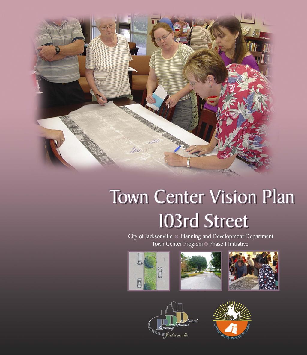
Town Center Vision Plan 103 rd Street
|
|
|
- Derrick Chase
- 6 years ago
- Views:
Transcription
1


2 Town Center Vision Plan 103 rd Street City of Jacksonville Planning and Development Department Town Center Program Phase I Initiative November 2004
3 Acknowledgments This document was prepared for the City of Jacksonville Planning and Development Department. It was developed through input from dozens of local participants. The development process spanned 5 months, from March 2004 through August We are grateful to the many community members who participated in the neighborhood workshops and contributed their time, energy, and Visions to this report. John Peyton Mayor City of Jacksonville Daniel Davis District 12 Representative Jacksonville City Council Warren Alvarez District 11 Representative Jacksonville City Council A special recognition is due JaxPride, a nonprofit coalition for visual enhancement, for their early and ongoing community visioning activities in Jacksonville. Their volunteer efforts have helped raise community awareness about the importance of having a Vision for neighborhood improvement. Thanks is also extended to Bishop Synder High School and its staff for graciously hosting both public workshops. Jeannie Fewell Director Planning and Development Department Jennifer Hewett-Apperson, AICP Town Center Program Project Manager Planning and Development Department Sponsoring Organization Westside Business Leader s Association (WBLA) Gary Dasher, President Joe Nairon, WBLA Town Center steering committee chair i Sutton Park Drive South Suite 200 Jacksonville, Florida fax Project Consultant This document was prepared by: Prosser Hallock, Inc. 103 rd Street Town Center Vision Plan
4 Contents 1. Overview Community Vision Focusing the Vision Expanding the Vision Implementing the Vision Maintaining the Vision Final Recommendations Conclusion ii 103 rd Street Town Center Vision Plan

5 1 Overview What is a town center? The phrase conjures an image of Main Street, of activity and livelihood, of a space that is historic, active, interesting, and inviting. A Town Center can take several forms. It may be an urbanized area, condensed and pedestrian oriented, with commercial enterprises and other amenities such as parks and plazas. Or, it may be a commercial corridor that links several neighborhoods together, serving both pedestrians and vehicles. As hubs of the community, Town Centers should be attractive and well-maintained. Aneighborhood is, first and foremost, designed for people, and not solely for cars. It must allow for a range of housing options to accommodate people in all stages of life: families with children, young college students, empty nesters, single professionals, and employees of local businesses. It must feature narrow, slow-speed streets where cars and pedestrians peacefully co-exist and residents can walk safely along tree-shaded sidewalks. A true neighborhood must also offer the pedestrian someplace worth walking to: a corner store, a cozy park, a nature trail, or a friend s house down the street. The walk itself must be interesting, featuring landscaped gardens, architectural details, and places to meet informally with neighbors. (Welcome to Vermillion Bowman Development Group. < default.html>) While this description hints at the character of a Town Center, the specific form and function can vary greatly. This report represents an effort by the 103 rd Street community to redefine their Town Center corridor with assistance from the City of Jacksonville through the Town Center Program. To be part of the Town Center Program, a Town Center must be at least 30 years old and must have been at one time an established commercial district or corridor at the heart of an existing community or neighborhood. 103 rd Street is an evolving corridor. Once a commercial corridor with a rural character, 103 rd Street has been widened over the years and now serves as a gateway into the rapidly developing west side of Jacksonville. Though the corridor serves as a gateway into the westside and Cecil Commerce Center, 103 rd Street does not feel like a gateway with its aging buildings and lackluster streetscape. Despite these changes, the 103 rd Street community recognizes the value of the corridor as a neighborhood and cultural resource. This Vision Plan is an effort to restore and improve the Town Center corridor through a community-based initiative and with the help and resources of the City of Jacksonville. Background The City of Jacksonville developed the Town Center Program as a means of providing support to local organizations for redeveloping areas of 1
6 town that have served the community and that still retain some character, historically, aesthetically, or otherwise. The City also recognizes the role these Town Centers can serve as Jacksonville grows: to provide shopping, service, and entertainment alternatives, support small and local businesses, and create meaningful and memorable places that define the City as whole. In the fall of 2003, the Westside Business Leader's Association (WBLA) applied for and received a grant from the City of Jacksonville for Phase I Visioning as part of the Town Center Program. Specifically, this Phase I effort creates a Vision for redeveloping the Town Center corridor located along 103rd Street, from Old Middleburg Road North west to Chaffee Road (see map on page 4). Once a Phase I Vision is completed, organizations are eligible to apply for Phase II funding that would enable development of construction plans; however, Phase I recipients are not guaranteed Phase II funding through the program. Phase III applicants seek construction funds to apply toward implementation. The Town Center Program is administered by the City of Jacksonville Planning and Development Department. Mission The mission of this project is to develop a Vision for 103rd Street that activates the needs and desires of the local community while incorporating the realities of cost, conditions, and other constraints. Neighborhood workshops were conducted on May 17, 2004 and June 21, 2004 to gather community ideas and opinions. This Vision Plan report is a direct result of that input. Planning Process To generate a Vision, a Project Team was created that included representatives from the City and professional planners, landscape architects, and engineers. The Team developed a streamlined process to encourage as much public participation and input as possible. Team leaders initiated the process with a meeting of WBLA representatives and identified key issues concerning the area. The Project Team then conducted a series of site visits to walk the area, discuss opportunities and constraints, and record information. INITIAL PROGRAMMING GOALS & OBJECTIVES PUBLIC WORKSHOPS SITE VISITS and DATA A COLLECTION VISION DEVELOPMENT DRAFT REPORT CITY & ORGANIZA GANIZATION REVIEW FINAL VISION PLAN 2


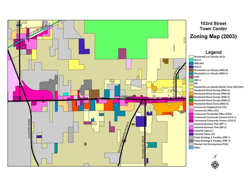
7 With preliminary analysis completed and information collected, the Team conducted two public workshops that were carefully organized to allow direct input of the participants, at both a personal level and a communal level. This input is detailed in the next section. The workshops concluded with a prioritizing of projects by the participants, allowing the team to then develop a plan for Phase II and Phase III implementation, as presented in this report. Plan Area The 103rd Street Town Center is the corridor along 103rd Street, from Old Middleburg Road North west to Chaffee Road. The area between Old Middleburg Road North and Old Middleburg Road South is predominantly older commercial development which is typical of a Town Center. West of Old Middleburg Road South, the corridor is primarily residential in use, though almost all of the corridor is zoned for commercial use. A map depicting the plan area is shown on the following page and a zoning map is found on page 14. Town Center corridor in Jacksonville (Deerwood Park) 3

8 4

9 2 Community Vision At the heart of this Visioning process are the comments, concerns, and dreams of the area residents. These are the people who know 103rd Street best, who live and work in the area, who use the roads and sidewalks, who work to improve local conditions, and who enjoy the use of the neighborhood. To create a realistic Vision for redevelopment, their input must be included. Therefore the Project Team developed a careful program to gather as much direct input as possible within a short timeframe. Background Data Prior to the first workshop on May 17, 2004, the Project Team conducted a site analysis and site visit to confirm significant existing conditions that would likely influence Town Center planning. A background data summary and zoning map are provided at the end of this section. First Workshop For the first workshop, the Project Team developed a survey to gather demographic information. This survey asked property owners and workshop participants to consider two important questions: Where are we now? and Where would we like to be? Participants reflected on these questions in a personal way to try to identify important issues, concerns, and visions for the future that would not be influenced or overshadowed in the open discussion to follow. The following is a summary of their responses to these questions. Their answers guided the Vision concept throughout its development. Who are we? The following questions were asked in the survey. (There were 30 respondents.) Your age? Under 15: : : 21% 41-60: 66% Over 60: 14% Are you married? Yes: 80% No: 20% Do you have school-age children? Yes: 24% No: 76% 5 What neighborhood do you live in? Country Oaks: 3% Blue Jay Ridge: 3% Plum Tree: 10% Other / No Response.: 14% Jax Heights: 17% Bent Creek: 55% Group discussion during the first workshop How long have you lived there? Less than 5 years: 59% 5 to 15 years: 14% Over 15 years: 24%
10 Is your home within walking distance of the Town Center? Yes: 86% No: 10% How often do you visit the Town Center? Once a week or more: 86% Monthly: 0% Less than once per month: 0% Do you own a business or work in the Town Center area? Own business: 10% Work: 7% Neither: 79% Where do you typically go for entertainment? Orange Park, Roosevelt Square, J.L. Trent s, Mi Toro, Outback, Olive Garden, Fast Boys Wings, cinemas, Applebee s, fast food, Red Lobster, Avondale Are there enough neighborhood parks in the area? Yes: 0% No: 100% Where are we now? To evaluate each participant s perspective on current corridor conditions and issues, the survey included a section that asked where are we now? Participants were asked to consider how they feel about their Town Center today and list their top three concerns. This question created a reference point on which to base the emerging Vision. The primary survey responses are listed below: 103rd Street is... lacking beautification with a consistent visual appearance. lacking managed growth development. in need of better traffic control. in need of a better image. lacking in family-friendly entertainment. unsafe. in need of more parks. in need of more jobs. in need of city utilities. connected to naval heritage. in need of environmental protection. seemingly neglected. Where would we like to be? Participants were also asked in the survey to answer the question where would we like to be? They were instructed to share the top three changes they would like to see in their Town Center in the future. The intent of both survey questions was to gather an unbiased and personal vision from each individual. Again, the primary responses are listed below: 103rd Street needs... an upgraded appearance like San Jose Blvd. or San Marco. new lighting, trash receptacles, and street furniture. improved streetscapes. consistent visual appearance. walking and bike paths. neighborhood parks. more traffic lights. to be safer to walk at night. a produce market. full city utilities. more restaurants. to be cleaner. The survey responses indicate a corridor that has experienced some decline but with a strong motivation for improving its condition, whether to protect property values, preserve 6
. The average age has increased from 27.5 in 1990 to 30.4 in 2000.")

11 resident safety and quality of life, or create a desirable, noteworthy community. Census data indicates: The total population has decreased over the last decade by 5% (from 5728 in 1990 to 5442 in 2000). The average age has increased from 27.5 in 1990 to 30.4 in The white population is decreasing (from 5181 in 90 to 4522 in 2000); the minority population is increasing (from 547 in 90 to 920 in 2000). Issues and Possibilities The first workshop was held on May 17, 2004 at Bishop Synder High School with over 75 community members in attendance. During the initial segment of the workshop, participants were given an opportunity to discuss and debate major issues that were raised or that the Project Team identified. The following is a summary of those issues: Image In 2000, 12% of the population had an educational attainment of high school graduation or higher (college or above). The average home sale price in 1990 was 74,300 dollars. 103 rd Street (from Chaffee Road to Old Middleburg Road North) is mostly zoned commercial and medium density residential. While residents and workshop participants recognize the issues in their community, they remain optimistic about its future, recognizing the potential of 103 rd Street to serve as a vital commercial asset to the community. The corridor is largely rural with an equestrian presence. The corridor is a major entry to Cecil Commerce Center. General corridor aesthetics need to be addressed. Community and Cultural Resources 7 Cecil Commerce Center is a regional resource. There are no playgrounds or passive parks along the corridor. The go-cart park (103rd Street Sports Complex) is a unique City feature, but is frequently noisy and crowded.


12 Natural Resources Landscaping McGirts Creek (the upper end of the Ortega River) crosses the corridor at the east end. The creek is attractive, but there is no access. Bridge fencing to prohibit access is unattractive and presents a negative image. Several parcels along the corridor are heavily wooded and could be targeted for preservation. Transportation The existing medians offer some opportunities for planting, especially if median openings are eliminated in selected locations. Mature pines and shade trees line the corridor outside of the right-of-way. Space within the right-of-way is limited for roadside landscape elements. Lighting, Utilities, and Drainage 8 Overhead utilities line the corridor. New bus service to the corridor offers public transportation opportunities. New shelters are needed at central locations. Most of the available right-of-way is used for roads, medians, and sidewalks. Existing cobra head street lights lack character, but could possibly be upgraded. Street lighting is only on the south side of the street, creating an unbalanced look and dark areas on the north side of the right-of-way. Opportunities may exist for expanded bicycle, pedestrian, and equestrian use of the corridor.


 study.")

13 Pedestrian Access/Walkability Safety Shallow setbacks and numerous driveways create some dangerous access issues, especially at the east end of the corridor. Pedestrian crossings need better definition at major intersections for safety and improved aesthetics. Sidewalks are typically 8 feet on the south side of the corridor and 5 feet on the north side. Sidewalks are generally in good condition but need widening at focal points. Sidewalks need better lighting, especially along the north side of the corridor. The Jacksonville Sheriff s Office can provide a Crime Prevention Through Environmental Design (CPTED) study. Architecture and Building Improvements 9 Signs Corridor development guidelines are needed to resolve visual confusion and functional conflicts between adjacent commercial and residential land uses. Signs along the corridor are mixed in age, size, and style. Entry signs or features and regularly spaced signs or banners are needed to identify the corridor area. Guidelines are needed to coordinate sign use. New awnings for storefronts are a desirable improvement. Dumpsters and trash containers should be screened from public view. Rear and side parking should be encouraged where space allows.

14 Group Work With personal visions and primary issues identified, workshop participants divided into groups centered around tables to brainstorm and begin the process of putting ideas and concerns onto paper. Group 2 Old West, Spanish, or equestrian theme Park or bird sanctuary near wetlands More police presence on the east end (substation where little church was) Light median with old-time lanterns or gas lanterns Wildflowers in median and along sidewalks Fire station Bike trails Oleander, pampas grass, crape myrtle, ornamental grasses, sedum The Project Team provided plan sheets, aerial photographs, zoning maps, and plenty of pens, markers, scales, tape, tracing paper, and other tools needed to translate ideas into images. Team members were on hand to help in the translation process, with the goal of developing a graphic Vision that responded to earlier comments and ideas. When they were finished, the groups presented their plans or Vision concepts to the overall group and responded to questions and comments. The following is a summary of each group s primary Visions: Group 1 Entry feature at the river similar to the one in Argyle Roundabouts Fountains Lighting down median or both sides to deter vandals Postal center (not full post office service) Lower speed limit by 10 mph Move go cart park to Cecil, use land for park Wildflowers, sago palms Group 3 Nice-looking, old-themed entries Preserves, keep area rural Small post office Bus pull out for safety Traffic signals at Bent Creek and new middle school Move go cart to Cecil Regulate signs, limit number Change name of road Group 4 Same desires as Group 3 with the addition of: Upscale restaurant Proper spacing of buildings Group 5 Mail drop at end of Middleburg Road Lighting on both sides of 103 rd, especially in the wooded areas Signs City water/sewer for all Bus stops/shelters for school kids on 103 rd, pull off for buses Stone or sculpted monument at entrance and smaller monuments (horse, flags) in other areas Group 6 Themed signs Oleander Brick pavers at crosswalks Decorative lighting, bollards 10
 roundabouts with statue or sign, surround with restaurants Front doors and parking away from street")
15 Signage where trucks and buses frequently access 103 rd Move or expand go cart Family park with walking trails and picnic areas Bike lanes on 103 rd Fire station Group 7 Change name of 103 rd to Cecil Parkway buffer zone on both sides of 103 rd Low maintenance plants Connie Jean (center) roundabouts with statue or sign, surround with restaurants Front doors and parking away from street Curves in sidewalk (avoid linear design) Extra roads to Normandy at Connie Jean or Rickola Use native plants Traffic signals Keep residential areas behind buffer zone away from street Center Program. Participants were also asked to consider projects that could be eligible for implementation through other funding programs. From this dialogue, the Project Team identified a staging approach that echoed participant desires. The proposed projects are listed below with the general participant response. Projects that met with general approval are listed in either Section 3 or 4 of this report, depending on whether they were considered for subsequent Town Center funding or as a future project to be accomplished outside the Town Center Program. Projects that received negative responses were dropped from the program. Nevertheless, their description is important for possible resurrection at a future time with different support or conditions than exist today. Proposed Project: Median Expansions Close median openings in selected locations to create safer roadway and add space for additional landscaping, especially large shade trees (current FDOT regulations specify a minimum median width of 12 feet to support large shade trees). Participant Response: Participants generally did not favor this project. Some reasons cited include: 11 Waste of money since future development will modify median openings regardless. Cause driving inconvenience Second Workshop During the second workshop held on June 21, 2004, the Project Team presented participants with a series of projects, translated from the Vision concepts of the first workshop, that would meet Town Center funding parameters. These projects were presented to allow an overall group discussion. Details such as timeline and budget were discussed to assess the feasibility of the concept and to gauge group support. Workshop participants were encouraged to prioritize projects based upon the projected funding for the Town Difficult to agree on locations that do not disadvantage adjacent property owners Proposed Project: New Landscaping Add landscaping, primarily street trees, along the corridor where space allows. Participant Response: Participants were in general support of this project, but expressed concern about utility conflicts. Proposed Project: Improved Crosswalks Add new brick pavers at existing crosswalks and possibly some major side streets. Participant Response: Participants were in general support of this project.
16 Proposed Project: New Entry Features Add new entry features at each end of the corridor and possibly at a center location. Participant Response: Participants were in general support of this project. Some additional ideas cited were: Improve the appearance of the McGirts Creek bridge to look like the Ortega River bridge in Ortega (Ortega Boulevard). Use the bridge as the east entry feature and create a new feature at Chaffee Road as the west entry. Entry features at each end should be smaller with a larger feature at the center. Use City-owned land at northwest corner of 103rd Street and Old Middleburg Road North for locating an entry feature. Entry feature themes should incorporate aviation, equestrian identity. Proposed Project: New Open Space Create new neighborhood open space along the corridor using available right-of-way near Shindler Road intersection. Participant Response: Participants were in general support of this project. Proposed Project: New Lighting Add new ornamental lights along corridor in selected locations to add visual character and improve pedestrian lighting. Participant Response: Participants were in general support of this project but had several comments: The high cost of fixtures impacts the budget There is a need for additional street lighting that may go beyond what the ornamental lights can provide. Must coordinate with JEA. Ornamental lights are important for differentiating area visually and attracting people. Proposed Project: New Banners Install new decorative banners on existing utility poles to create identity for area or to inform the public of events. Participant Response: Participant response was mixed with most in support of banners but several who were concerned with better linking the banners with corridor businesses: Businesses could purchase banners to stretch dollars, with business names or logos incorporated into banners. Directional signs that include features, locations, and businesses as seen in Downtown Jacksonville were also considered as part of a way-finding or space-identifying tactic. Banners could create the impression of a thoroughfare to Cecil Commerce Center, rather than reinforce a sense of place. Proposed Project: Street Furniture Install new benches and trash receptacles at high-use and visible locations along the corridor. Participant Response: Participants supported this project with the provision that the metal benches illustrated in the presentation be substituted for wood benches that stay cooler and are more in keeping with the character of the neighborhood. Proposed Project: New Bus Shelters Install new bus shelters at high-use and visible locations along the corridor. Participant Response: Participants supported this project. Next Steps The next section describes the implementation program for the Vision projects that fit within the Town Center funding parameters. Viable projects identified in the workshops that do not fit within the Town Center Program are described in Section 4. Those projects can be implemented through additional funding, support, and resources by WBLA (or other related civic groups such as JaxPride or Greenscape). 12
17 Project Background Summary The following summary provides general information about the project area considered in establishing the Vision: Planning District(s): 4 (Southwest) City Council District(s): 11 and 12 City Council District Representative(s): Warren Alvarez (11) and Daniel Davis (12) Length of Town Center Corridor: 3.3 miles Major Cross Streets: Old Middleburg Road North Old Middleburg Road South Shindler Drive Chaffee Road Corridor right-of-way jurisdiction: FDOT Width of Right of Way: feet Number of Study Area Property Parcels: 126 Zoning: CO (23) RMD-A (5) CCG-1(9) RMD-C (6) CCG-2 (32) RMD-E (7) CN (4) RMD-MH (1) PBF-1 (2) RLD-MH (1) PBF-2 (2) PUD (9) Curb to Curb Width of Roadway: 60 feet Roadway Classification: Minor Arterial Posted Speed Limit: 45 mph Number of Lanes: 4, 6 east of Old Middleburg Road South Lane Width: 12 feet Maximum Peak Hour Traffic: 3,144 Percent of Total Capacity Used: Total Capacity Available: Level of Service: D Average Daily Trips (2002): 22,000 Number of Signalized Intersections: 4 Number of Bus Stops: 23 Electrical Service Location: Overhead Historic Buildings and Sites: None Churches along Corridor: 103rd Street Baptist Church West Jacksonville Church of God New Hope Baptist Temple Westside Family Worship Center Civic Buildings along Corridor: None Public Parks along Corridor: None Typical Sidewalk Material: Concrete Typical Width of Sidewalks: 6 feet Typical Street Light Type: Cobra Head Typical Street Light Spacing: 150 feet 13
18 14
19 3 Focusing the Vision Working within the Town Center Program This section describes the projects selected by the community that support their Vision and that could be funded through the Town Center Program. While funding is not assured because a new application must be submitted and approved for Phase II and Phase III projects, the projects listed in this section meet Town Center funding requirements. Section 4 describes other projects supported by the community as part of the long range Vision that are not eligible for Town Center funding or that are not suitable as a Town Center funded project due to their projected budget or complexity. Most of the improvements envisioned for the 103 rd Street corridor are expensive, especially given the length of the study area. Not all of the projects envisioned by the community can be installed within the limited budget of the Town Center Program, a maximum of $828,750 per Town Center applicant at the time of this report. Therefore, this section represents an effort to prioritize those projects supported by the community that can utilize Town Center funds for design and implementation. With community input, the Project Team has also attempted to distribute potential funding among the projects to achieve the maximum visual and functional impact for the given dollars. The following program has been developed with the assumption that full Town Center funds would be available for design and implementation. It has also been developed with the understanding that certain projects might also be eligible for funding through other programs, such as the City of Jacksonville s Tree Mitigation Trust Fund (section 5 describes funding alternatives). The cost estimate found at the end of this section lists the proposed projects and an estimated cost for installation. While reasonably accurate given the conceptual nature of this report, the primary purpose of the cost estimate is to allow the community to prioritize projects based on cost in relation to desirability. This gives the projects an added dimension of reality. The projects in this section are listed in order of priority according to the community s responses during the workshops and their understanding of projected costs. This order is intended to guide future decisions in the event full funding is not available, or if the program must be separated into different design or construction phases. Right-of-Way Improvements Town Center funds are limited to improvements within the right-of-way, so most of the community s and Project Team s efforts focused on improvements to that space. Projects outside the right-of-way that are part of the community Vision are described in Section 4. The Florida Department of Transportation (FDOT) maintains jurisdiction over the right-ofway along 103 rd Street. Proposed improvements and maintenance within the right-of-way is subject to the final approval of the FDOT. The improvements recommended below are typically agreeable to the FDOT, the City of Jacksonville, and other governing bodies, provided they meet established design guidelines and that provisions are made regarding additional maintenance requirements. 15


20 The following group of projects were identified as first priority projects that would qualify for Phase II and Phase III funding under the Town Center Program and that would make a significant, positive impact to the corridor. These projects are right-of-way improvements that could be accomplished without excessive difficulty. They fit together as a package that meets many of the objectives identified by the workshop participants. Some of these improvements encourage private property enhancements that respond to participant visions for renewal. Most importantly, these improvements are highly visible and fit within the available funding parameters. Other viable projects identified as part of the Vision but outside the funding parameters of the Town Center Program are described in Section 4. Corridor Theme Workshop participants identified the new Westside Regional Library being constructed on Chaffee Road, north of 103rd Street, as the guiding example for a visual corridor theme. The new library is built in a modern style, but with a western design character, incorporating such signature elements as natural stone veneer, exposed wood framing, and metal roofing. The application of a strong architectural theme would help significantly improve corridor aesthetics and should be applied where possible to the project elements in this section. Ornamental Lighting Install new ornamental light fixtures at high-use intersections and focal points. Workshop participants indicated a strong desire to upgrade the lighting along the corridor, both functionally and aesthetically. There are two light types that were discussed for meeting this end: the overhead street lights and pedestrian-scaled post lights. The overhead lights meet functional street lighting requirements, while the pedestrian-scaled lights are purely decorative accents that provide some supplemental light. The existing overhead street lights are standard cobra-head types, mounted to the concrete utility poles. These lights are located along the south side of the corridor only. Workshop participants noted that this condition creates inadequate lighting along the north side of the street, especially for the sidewalk, and were especially concerned about the safety issues this created. To rectify this situation, the utility provider (JEA) and the Public Works Department should consider an 16 analysis for improving the street lighting along the corridor, ideally balancing the street lights on each side of the road, and perhaps using the medians as well. This analysis should be undertaken as part of the Phase II process so that some Town Center funding could be applied toward upgrading all overhead fixtures. Architectural Rendering of Westside Regional Library showing proposed corridor theme (image courtesy of Akel, Logan, and Shafer, PA) JEA-approved ornamental light fixture Workshop participants favored replacement of the overhead fixtures with a decorative post style, as was done in San Marco. However, the greater dimensions and different function of the corridor appear to preclude this approach. Instead, workshop participants were presented with the option of using the newly approved JEA


21 teardrop fixture (pictured below) that would be a more appropriate replacement type. Participants agreed that this style would complement the proposed corridor theme and be maintainable by JEA. The cost estimate at the end of this section includes an approximation of the funding required to replace the existing cobra-head fixtures and arms with Proposed JEA teardrop fixture the teardrop fixtures and decorative arms, but remounted to the existing concrete poles. New ornamental poles would be an additional expense. The estimate assumes a similar quantity and spacing to the existing lights. Actual locations and quantities will be determined in Phase II. This estimate is intended to provide JEA with significant dedicated funding with which to initiate the project, but not to cover the entire cost of upgrading the street lights along the corridor. Pedestrian-scale ornamental lights should be installed at primary intersection or where pedestrian use is greatest. Their application is intended to create a heightened appearance for those locations, as well as provide some additional lighting. A 10 to 12-foot height is appropriate and a spacing of approximately every 20 or 30 feet would focus attention at a lower level, creating a more pedestrian feel. The fixture type should be selected that would complement the JEA teardrop fixture. Consideration should be given toward maintenance of these lights as well. If a fixture is selected that is not a JEA standard, then the community must assume maintenance of those fixtures, including replacement of dead bulbs and damaged poles. The community must also consider collision liability if they assume responsibility for the fixtures. Selective use of pedestrian-scale decorative fixtures would give 103 rd Street a renewed and individual identity within the City. The Project Team has estimated 10 new ornamental lights for each of the following 6 intersections (a total of 60) for best visual impact and best distribution of Town Center funding: Old Middleburg Road North Shindler Drive Old Middleburg Road South Connie Jean Road Piper Glen/Samaritan Way Chaffee Road Landscaping Install new plants along 103 rd Street where space allows. The addition of new landscape plantings along the 103 rd Street corridor will greatly improve the aesthetics of the road. Trees, more than any other single element, will create the greatest visual impact. Evenly spaced trees create a pleasing visual rhythm along the road and provide added protection for pedestrians when located between sidewalks and roads. Trees also add environmental value to the corridor by increasing shade, filtering dust and pollutants, and providing a habitat for birds and other animals. Plant Locations Ornamental, pedestrian-scale light fixtures at the Park and King Town Center in Avondale There are planting limitations along 103 rd Street imposed by existing conditions as well as state and local regulations. There are two primary planting zones: roadsides and medians. 17

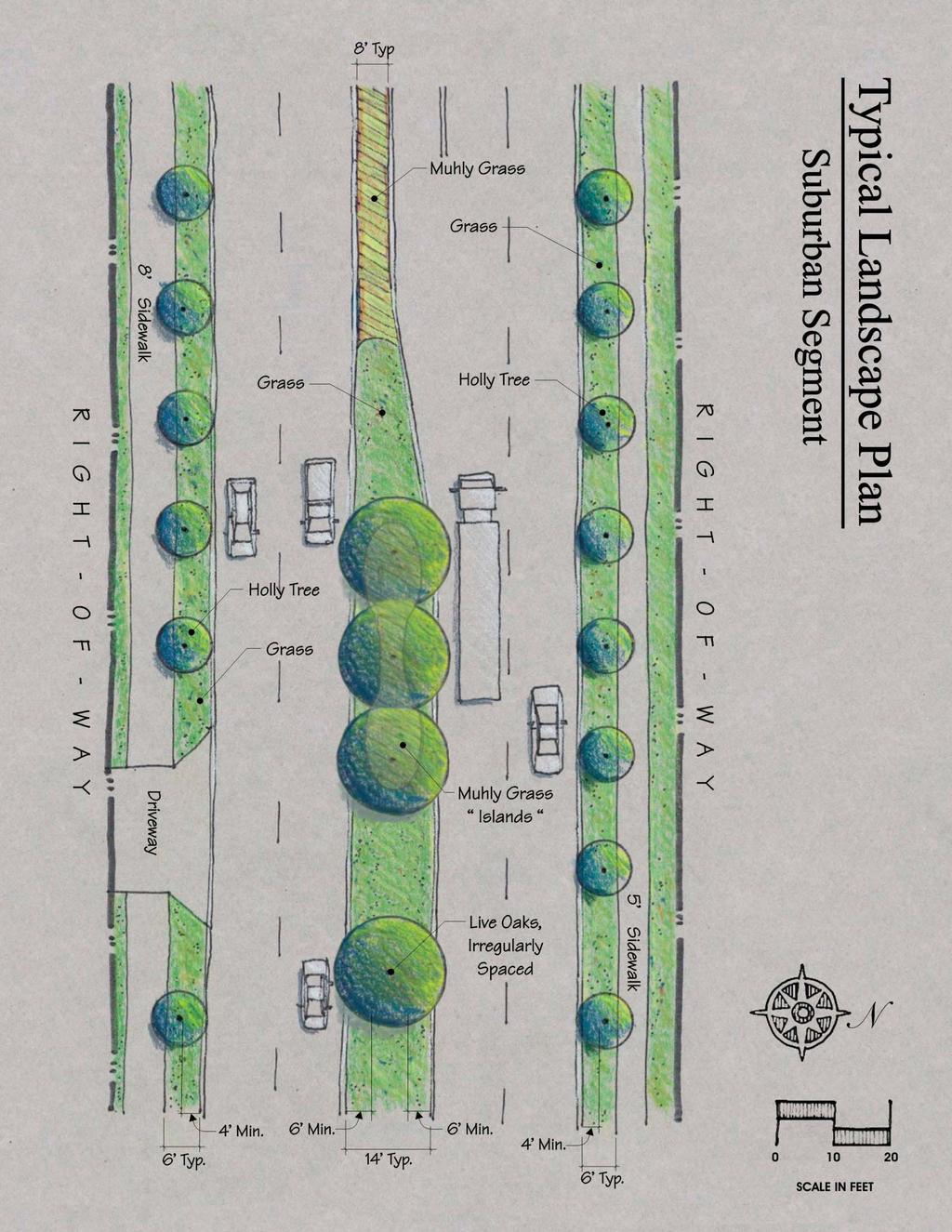
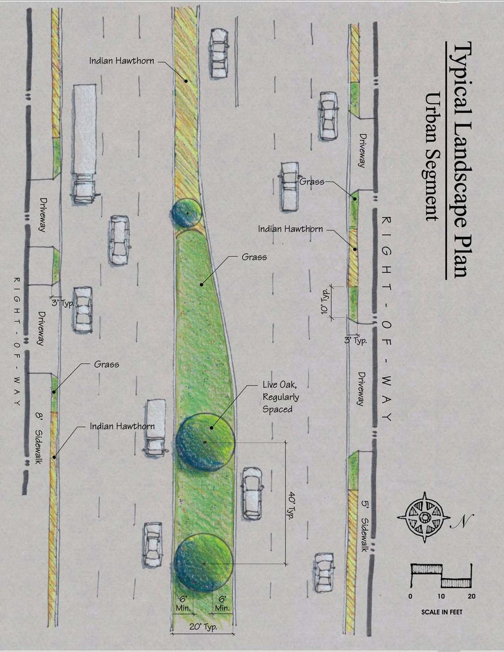
22 Typical section of road found in the suburban segment of the corridor west of Shindler Road FDOT sight distance at intersections standard details Typical section of road found in the urban segment of the corridor east of Shindler Road Roadsides The space between the back of the road curb and the edge of the sidewalk averages between 3 and 6 feet. Space between the outside of the sidewalk and the right-of-way line varies, though in many instances is appears there is little or no planting space available. Adjacent property owners have often built fences or parking lots up to the edge of the sidewalk, eliminating planting space within the right-of-way. Also, many segments of the corridor exhibit mature trees along the right-of-way line, limiting the need and space for new adjacent plantings. The space between the road and sidewalk was considered the most viable and appropriate location for new street trees. The FDOT maintains clear zone safety setback and visibility requirements for trees and landscaping within the right-of-way. For 103 rd Street, the setback for trees along the sides of the road is 4 feet from the edge of the outer travel lanes. The City of Jacksonville also maintains a setback requirement for trees to edges of pavement to reduce eventual damage to the pavement. For larger shade trees this setback is 4 feet; for smaller trees, the setback is 2 feet. Given these requirements, only smaller trees would be allowed along the sides of the 103 rd Street corridor, and these could be planted where space is at least 6 feet. Where space is less than 6 feet, small shrubs and ornamental grasses could be planted to create visual interest and provide greater protection for pedestrians. Medians The FDOT requires median trees to be set back at least 6 feet from the face of the curb. This necessitates a minimum width of 12 feet for medians to support trees. Medians narrower than 12 feet must use shrubs and groundcovers. At intersections and median openings, a visibility window must be maintained that limits the mature or maintained height of shrubs and groundcovers to 2 feet, and the lowest tree branches to 5 feet (see illustrations above). Because there are many median openings with turn lanes that reduce median widths to less than 12 feet, the Project Team proposed closing and merging some openings during the community workshops. This would provide additional space for trees while improving traffic safety. However, this proposal was met with significant resistance as 18

23 Roadsides Roadside planting space is limited to small trees, shrubs and groundcovers. There are several species that would be suitable for the 103 rd Street corridor, in terms of hardiness and appearance. The community supported crape myrtles and holly trees as appropriate selections. The table on page 20 designates recommended species and spacing for the corridor. Crape myrtles used as median and street trees in La Villa recorded in the previous section. Therefore, the Project Team focused on existing median locations in determining the cost estimate. Nevertheless, the typical plans found at the end of this section for planting wide medians would apply to new medians in the event median openings are merged in the future. For ends of medians and where visibility requirements restrict tree planting, shrubs or groundcovers should be installed. Shrubs and ornamental grasses are much lower maintenance than smaller groundcovers once they are established. Smaller groundcovers, even after establishment, require more dedicated maintenance to remove weeds, fertilize, mulch, and prune. Nonetheless, groundcovers, especially flowering annuals and perennials, are generally very attractive additions to the landscape. When well maintained, they visually communicate the care given to the area. These should be concentrated at high-use intersections and where dedicated maintenance is assured. Plant Types The corridor segment between Old Middleburg Road North and Old Middleburg Road South is decidedly more urban than the segment west of Old Middleburg Road South. The segment west of Old Middleburg Road South is more suburban in character, even rural toward the western end. Landscaping can be used effectively to match the different conditions of the corridor and to reinforce the positive attributes of each. Medians Median spaces, with their greater width, offer opportunities for large trees to be introduced in addition to small trees, shrubs and groundcovers. A minimum setback of 6 feet from the face of the curb is required by FDOT. Therefore, wherever median widths are 12 feet or greater, large trees should be planted. Unfortunately, within the project area, most medians associated with turn lanes appear to be between 7 and 9 feet in width, prohibiting trees in these spaces. Shrubs and ornamental grasses should be used where median widths are less than 12 feet and for 19 underplanting wide median segments intermittently. Mowed grass is the default plant material where trees or groundcovers are not proposed or feasible. Because all of the medians are currently grassed, new grass is not part of the cost estimate. Workshop participants strongly favored large shade trees such as live oaks for the median spaces along the entire corridor. Tree spacing could be used to differentiate the rural and suburban corridor segments. Regularly spaced shade trees would respond appropriately to the commercial, developed quality of the urban segment, while irregular, grouped spacing would reinforce the suburban segment character. The recommended plant species and spacing are listed in the table found on the next page. Final selection of plant types, quantities, and locations will be made during the Phase II design process.
24 Landscape Species and Spacing: Where space between the face of median curbs is 12 feet or greater: Quantity Live oak (Quercus virginiana) Where space between the back of curb and the sidewalks is 6 to 8 feet: Crape myrtle for the urban segment (Lagerstroemia indica Tuscarora ) Foster holly tree for the suburban segment (Ilex X attenuata Foster #2 ) Where roadside space is less than 6 feet between curbs or sidewalks, or less than 12 feet between median curb faces: Indian hawthorn for the urban segment (Raphiolepis indica) Muhly grass for the suburban segment (Muhlenbergia capillaris) Recommended Spacing: Live oak: 40 feet, on center Small tree (roadside): 20 feet, on center Indian hawthorn: 2 feet, on center Muhly grass: 2 feet, on center Landscape quantities are difficult to estimate given the variety of unknown limiting conditions within the study area. However, some assumptions have been made to establish an estimate of cost as presented at the end of this section. The following quantities are provided with a rationale to give some understanding behind the estimate. Roadside Trees Roadside quantities are based upon the corridor (3.3 miles) and a typical small tree spacing of 20 feet. The Project Team has estimated 1,200 small trees (600 per side) to be required to line 103 rd Street roadside within the project area. This estimate roughly accounts for intersections, driveways, visibility, and other conflicts. Median Trees Median widths are currently 7 to 10 feet where turn lanes are present, and 15 to 18 feet without turn lanes. Based upon aerial photographs and site analysis, the Project team has estimated space is available for approximately 102 live oaks (or similar trees) spaced on 40 foot centers. Because landscaping was given a high priority during the workshops and because some or all of their cost could be paid using Tree Mitigation funds (see Section 5), a large percentage of the budget is dedicated to new trees. Shrubs and groundcovers Shrubs and grasses are estimated by area. An average area of 2000 square feet is applied for each of the 13 larger intersections along the corridor, for a total of 26,000 square feet. The square footage for each intersection should be distributed within the narrow median segments and along the roadsides as space allows. This quantity should also provide for some limited plantings in combination with large trees within the medians. The 20 estimated groundcover area is intended to provide sufficient quantity for design flexibility in Phase II. Intersection Improvements The following intersections should be modified to improve pedestrian access to the commercial district, better connect adjacent residential areas, improve safety for crossing pedestrians, and enhance the visual quality of the corridor. Brick and Concrete Pavers The use of colored and textured road pavers or similar ornamental paving material are recommended throughout this section as a key element of intersection improvements. Colored brick or concrete pavers have been used with success throughout the city. They provide for better visual definition of crosswalks and intersections and drivers notice the sound and slight bumps they create when passing over them. At a minimum, they create a more sophisticated and
25 21
26 22
")
27 Typical Landscape Section Urban Segment (looking west) 23 Typical Landscape Section Suburban Segment (looking west)


28 finished look to an intersection. Specific paver colors and patterns will be determined during Phase II development. Traffic Signals Brick paver crosswalk in LaVilla The traffic signals recommended in this section are single mast arm types that replace signals hanging from overhead wires with unified metal structures. The City is using mast arm signals for new intersections, such as Chaffee Road at the west end of the corridor, and to upgrade old intersections in some locations, such as Old Middleburg Road North. These signal types are commonly painted black but can be painted other colors, such as muted browns or greens, to complement the surrounding area. They provide a clean, modern, and unified appearance for intersections and are generally more visible to motorists and pedestrians. Replacing current suspended fixtures on 103 rd Street with mast arm signals would help improve the look and function of the corridor. Single mast arm traffic signal at the Old Middleburg Road North intersection The following improvements are recommended for 103 rd Street intersections: 103 rd Street and Old Middleburg Road North: Install new 8-foot crosswalks on all sides of intersection using colored concrete road pavers. 103 rd Street and Shindler Drive: Replace existing signals with single mast arms, colored black and consistent with other City intersection improvements. Install new 8-foot crosswalks on all sides of intersection using colored concrete road pavers (see illustration on the following page). 103 rd Street and Old Middleburg Road South: Replace existing signals with single mast arms, colored black and consistent with other City intersection improvements. Install new 8-foot crosswalks on all sides of intersection using colored concrete road pavers. 103 rd Street and Rockola Road: Install new 8-foot crosswalk on south side of intersection using colored concrete road pavers. 103 rd Street and Connie Jean Road: Install new 8-foot crosswalk on south side of intersection using colored concrete road pavers. 103 rd Street and Piper Glen/Samaritan Way: Install new 8-foot crosswalks on north and south sides of intersection using colored concrete road pavers. 103 rd Street and Chaffee Road: Install new 8-foot crosswalks on all sides of intersection using colored concrete road pavers. 24


29 Existing conditions at 103rd Street and Shindler Drive 25 Illustration of proposed improvements to the 103rd Street and Shindler Road intersection McGirts Creek Bridge Improvements Replace or upgrade the existing bridge railing and fencing with decorative railing and fencing. Install new bridge accent lighting. The bridge crossing McGirts Creek has served as an entry into Jacksonville Heights for many decades. The creek is the upper end of the Ortega River and is pristine at the crossing. Unfortunately, it is not readily apparent to passing motorists. The current bridge Existing Ortega Creek bridge structure limits visibility. The chain-link fences mounted to the bridge railings were apparently installed to prevent fishing or jumping from the bridge. They are unattractive and limit visibility, giving a negative impression of the community. Workshop participants pointed to the Ortega River bridge in Ortega (Ortega Boulevard), which was recently refurbished, as a good example of how decorative features could be integrated into a bridge. They also identified this project as an excellent means of reinforcing the architectural theme along the corridor. Three primary improvements are proposed for the bridge to meet this objective, new rail cladding, new fencing, and new lighting. The bridge railing is currently a standard concrete barrier wall type. To maintain the safety quality of


30 this design and minimize construction costs, a veneer could be applied over the Ortega River bridge existing wall. A natural stone matching other improvement elements, such as proposed entry monuments and bus shelters, could be mortared to the roadside face and ends of the walls without compromising the integrity of the wall. Fencing above the barrier wall should be reconsidered. No such fencing is present on the Ortega River bridge or others like it throughout the city. Workshop participants suggested the existing chain link fence was installed to prevent people from jumping off the bridge. This deterrence should be reevaluated, especially since the chain link fencing presents a negative community image. If upon further evaluation, fencing is determined to be truly necessary, a more decorative style should replace the existing chain link. An open, metal picket style is recommended as durable and visually appropriate. New fencing should be painted black to reduce its appearance and permit easier viewing of the waterway. Decorative lighting should be installed atop the bridge railing wall, and most prominently at the four corners to create a dramatic visual impression and provide some additional sidewalk lighting. Bridge lights, however, do not need to be overly bright and should instead provide a low, soft light that properly accents the bridge itself. The fixture style should complement those selected for street and ornamental lighting, and agree with the overall corridor theme. These three alterations, would dramatically improve the appearance of the bridge and create a memorable community feature. The cost estimate at the end of this section provides anticipated installation expense for each of these features. As an additional consideration, public access to the river near the bridge should be considered. This project is further described in Section 4. Entry Monuments Install new masonry entry signs or monuments at each end of the corridor and near the center of the corridor. Workshop participants supported the idea of installing new entry monuments to help identify the 103 rd Street Town Center corridor. A monument style sign of masonry or metal construction would be more visible and durable than a conventional wood sign. A vertically oriented monument-type sign would provide a positive contrast with the many horizontally oriented commercial signs along the corridor, helping it stand apart visually. A vertical structure also takes up less space, a concern where available right-of-way is limited. Since entry monuments are typically located near the road, a vertical sign that has a smaller footprint also reduces the chances of an automotive collision. Stacked stone, brick, and stucco veneer are appropriate masonry materials that would blend with area buildings, both new and old. A stacked stone style with wood accents is recommended to reinforce the corridor theme and help establish a complementary style for new buildings along the corridor. San Marco entry monument Monuments should have an affixed sign face, preferably metal, that announces the entry to the 103rd Street Town Center. Each sign could also be used to identify the 26

31 Entry monument with stacked stone at Word Golf Village platted neighborhoods associated with the 103 rd Street corridor. Entry monuments should be lighted for night visibility. Workshop participants suggested that a logo or symbol be created to pay homage to the history and tradition of the area. Several logo themes were discussed, with equestrian and aviation themes being the most popular. One or both of these could be incorporated into the entry monuments. Three primary locations for entry monuments are proposed. Workshop participants favored coordinating an east end monument with the Ortega Creek bridge to reinforce a boundary. To meet this objective, a new monument could be built into the bridge railing or constructed in the median just west of the bridge, oriented toward westbound traffic. At the west end of the corridor, an entry monument should be located in the wide median just east of Chaffee Road and oriented toward eastbound traffic. The community favored a third monument to be located near the center of the corridor that would be taller or more prominent than the two at each end. Such a monument could be located in the wide median space near the intersection with Connie Jean Road. Bus Stop Improvements Upgrade primary bus stops along the corridor with new benches, trash receptacles, and shelters. The Jacksonville Transportation Authority (JTA) recently extended bus service to the 103 rd Street corridor. Workshop participants were in favor of dedicating a small percentage of Town Center funding toward installation of new bus shelters at some high-use locations, and benches and trash receptacles at others. Another consideration during the workshops was coordination of school bus routes to allow double use of the shelters, giving school children better protection from the elements. This would require further coordination between the community, the JTA, the WBLA, and the Duval County School Board. New bus shelters would introduce another visible element within the right-of-way to further define the corridor, especially if they are built in a unique style that complements the visual character of the corridor. The community expressed agreement over using the new Westside Regional Library s architectural design as a theme for new bus shelters. Strong architectural components such as stacked stone, exposed timbers, and metal roofing should be considered in the design of new bus shelters. The cost estimate provides funding for approximately 6 new shelters along the corridor. The JTA, in an effort to encourage and promote bus use, has indicated a willingness to match construction funds for new, nonstandard shelters. The final cost and location of each bus shelter will be determined during the Phase II process. The community also expressed interest in a larger, Kiss and Ride transit stop at the east end of the corridor. This project is described in Section 4. Street Furniture Install new benches and trash receptacles along the corridor in appropriate locations and as space allows. Workshop participants indicated a need for additional outdoor seating and trash receptacles at major intersections and other locations along the corridor, such as high-use bus stops. Bench and trash receptacle types that would be 27


32 well-suited to the corridor in terms of aesthetics and durability are pictured below. Twenty benches and 20 trash receptacles are estimated to initially complement the proposed improvements. Specific types, colors, and locations will be identified during the Phase II process. adjacent convenience store adds to the potential use of this location as place where people could also enjoy an ice cream or a cold drink. Public access to Ortega Creek, as described in the next section, could be located on the south side of the corridor to create a third level of activity to this space. Downtwown bench and trash receptacle standards that would be suitable for 103 rd Street The planned realignment of Old Middleburg Road South through the Better Jacksonville Plan will also create additional right-of-way space at this intersection. A new intersection is planned for Old Middleburg Road South further west of the existing intersection. A cul-de-sac is planned for the terminus of the existing Old Middleburg Road South, creating a new parcel of open space that could support the proposed improvements. While this project is already planned, designs are very preliminary and an implementation schedule is not yet available. Therefore, the proposed improvements are based upon the current configuration. If plans are finalized during the Phase II process, the new right-of-way should be factored into the design. 28 Open Space Seating Area Create a new seating area with benches, pavement, landscaping, and lighting, using available right-ofway space on the south side of 103 rd Street between Shindler Road and Old Middleburg Road South. The Northwest/Southwest Vision Master Plan identifies this location as a potential activity node. Its situation between two large intersections and its proximity to Ortega Creek and nearby commercial uses, support the creation of a pedestrian-oriented open space at this location. Workshop participants were also in favor of this project as it could meet the need for more neighborhood open space. This would not be a park, but rather a visible and accessible place for pedestrians to gather and sit. Envisioned improvements call for creation of a paved space of at least 15 square feet using brick pavers, with at least 4 ornamental lights, at least 3 shade trees, and some supplemental landscaping. As with other right-of-way improvements, this space would require an additional level of maintenance not typically supported by FDOT. Small public seating area in Leesburg, Florida Location of a new bus shelter near this space would help it serve as an activity node. The


33 Decorative Banners The repetitive use of decorative banner signs was supported by workshop participants as a means of further identifying the Town Center corridor. Decorative banner arms have been used in other areas of Jacksonville with success to create a sense of place as well as advertise local events. The new ornamental lights recommended earlier in this section should be selected with banner arms to support this need. The existing concrete utility poles along the corridor can also be fitted with support arms to allow presentation of new banners. The WBLA should consider a visual theme for the banners, such as a specific color and logo that could be presented on every banner. This would help identify the corridor and advertise the WBLA to the community. To provide an initial quantity of banners for the corridor, 160 banner signs and arms were estimated. This quantity is intended to cover the estimated amount of overhead and pedestrian-scale street lights along the corridor. Final costs, and locations for the banners will be determined during Phase II. Irrigation Supplemental irrigation for the plants specified in this report is recommended but is not critical to their success. The recommended plant species are hardy and well suited to the harsh urban environments typical of this corridor. Once established, ordinarily a one-year process, these plants will live without supplemental irrigation. The cost estimate on the following page provides a broad approximation for an automated irrigation system for the plants recommended in this section. The Department of Public Works will provide final requirements, designs, and feasibility of irrigation systems as a part of Phases II and III. In every circumstance, maintenance responsibility for an automated irrigation system must be resolved prior to completion of Phase II plans. Cost Estimate The Project Team prepared a cost estimate for the projects described in this section. It is based upon current construction trends and material and labor costs. It is also based upon a conceptual plan. Dimensions and takeoffs are averages and based upon some assumptions. This estimate must be accepted as such and not be interpreted as absolute. A more accurate budget will be developed during the Phase II construction plan development. 29 Decorative banners applied to ornamental and street light fixtures at World Golf Village A note on methodology: Each project was broken into its major components and calculated with fixed unit costs representative of current construction averages. Unit costs include labor and installation hardware. All totals include a 15 percent contingency to allow for non-included and unforeseen costs, such as mobilization, permitting, and buried hazards.
34 Cost Estimate 103rd Street Maximum Phase III Funding: $828,000 Project Type Quantity Unit Unit Cost Sub- Total Ornamental Lighting $598, Pedestrian-scale lights 60 EA $4, $270, Overhead street lights 100 EA $2, $250, Contingency 15% $78, Landscaping $522, Large median shade trees 102 EA $ $76, Small roadside trees 1,200 EA $ $300, Shrubs and groundcovers 26,000 SF $3.00 $78, Contingency 15% $68, Crosswalks $104, Intersection crosswalks 6,500 SF $11.00 $71, Side street crosswalks 2,880 SF $11.00 $31, Contingency 15% $1, McGirts Creek Bridge Imrpovements $80, Masonry cladding 1,400 SF $25.00 $35, New ornamental fencing 400 LF $50.00 $20, Ornamental bridge lighting 20 EA $ $15, Contingency 15% $10, Entry Monuments $51, Masonry entry monuments 3 EA $15, $45, Contingency 15% Bus Stop Improvements $6, $69, Custom designed shelters 6 EA $10, $60, Contingency 15% Street Furniture $9, $46, Benches 20 EA $1, $24, Trash Receptacles 20 EA $ $16, Contingency 15% Open Space Seating Area $6, $57, Small open space in right-of-way 1 LS $50, $50, Contingency 15% Decorative Banners $7, $52, Banner signs and hanging arms 115 EA $ $46, Contingency 15% Irrigation $6, $508, Trees 1,302 EA $ $390, Sod and Groundcovers 26,000 SF $2.00 $52, Contingency 15% $66, Subtotal $2,092, Tree Mitigation Reimbursables $941, Trees $376, Irrigation $508, Contingency 15% $56, Total Estimate $1,150,
35 4 Expanding the Vision Non-Town Center Program Projects The following projects and improvements are listed as a separate group than those described in the previous section because of their dependency on outside elements, budget constraints, or unknown variables to reach completion. Nonetheless, they are important projects that were identified and discussed in the workshops, and they should continue to be considered for coordination, funding, design, and implementation. If political and financial support are found for some or all of these projects, they could be designed and installed concurrently with the projects described in Section 3. PROJECTS within the PUBLIC RIGHT-OF-WAY: These projects meet Town Center funding requirements as improvements to the right-ofway, but are too large in scope to be feasible or best uses of available funding according to community input. Locating Overhead Wires Underground Workshop participants unanimously agreed that locating overhead utilities underground would improve the aesthetics of the corridor. Aging utility poles could be removed, sidewalk space expanded, ugly wires buried from sight, and trees no longer required to be severely pruned, but there are cost and coordination issues that restrict this course of action. The dollar cost for removing overhead utility wires and burying them underground is extremely high. Available Town Center funds would not come close to covering this expense, even if it was the only project recommended. Funds are much better allocated to those improvements outlined in the previous section that will have a positive visual impact and that will improve pedestrian access to the Town Center. Nevertheless, because the community was extremely united in this desire, this project remains part of the Town Center Vision. JEA, as the electrical utility provider, has indicated in word and practice a desire to put their wires underground, and this is their general preference with new development. Burying existing wires in an older neighborhood, however, presents major challenges. The technology exists to jack and bore the wires underground without disturbing the surface, but it is a costly exercise. Additionally, other service providers that share the overhead lines with JEA, such as telephone and cable, must also agree with this direction for it to occur. It is not clear who would be responsible for paying for this service as no one party feels they should assume the full cost. In other areas of town, JEA has participated in burying their overhead lines when major road or utility work has occurred. Repair or replacement of existing underground utilities, like storm sewers or water lines, would be a prime example of projects that could be coupled with relocation of utility lines underground. The most likely scenario for procuring underground corridor utilities would be during the planning stage of the next major roadway construction. 31

36 To move this project forward, the WBLA should create a subcommittee to spearhead the burying of overhead utility lines along 103 rd Street. The committee should solicit support from their City Council District representatives and create an active dialogue with JEA and the Public Works Department to create a priority for this project. In addition, the committee should solicit support from area business leaders, the mayor s office, and other interested parties to assist with the cost and scheduling of this effort. Roundabouts Workshop participants indicated preferences for new roundabouts at several intersections along the corridor: at the intersections with Shindler Road, Old Middleburg Road South, Chaffee Road, and most prominently, near the center of the corridor at the intersection with Connie Jean Road. Roundabouts could add significant visual interest to the area and serve as memorable features for the Town Center corridor. Highly visible items such as fountains or sculptures could be located in the center of the circles. New roundabout on SR A1A at the entrance to Amelia Island Plantation But fitting a new roundabout into the existing right-of-way is problematic. The minimum diameter for an urban, two-lane roundabout is 150 to 180 feet (Kittleson and Associates, Inc., Roundabout Planning and Design, 1999). A detailed study is required for each proposed location to determine existing traffic volumes, crash histories, right-of-way constraints, utility and sewer constraints, and other issues that would affect the feasibility of a new roundabout. Each intersection proposed for a roundabout would require acquisition of additional right-ofway to fit the circles into the roadway. This adds another level of expense and difficulty to the project, and it prohibits use of Town Center funds since those funds cannot be used to purchase or improve private property. The type of road is a significant consideration for retrofitting a roundabout into an intersection. 103 rd Street is a minor arterial carrying traffic loads averaging 22,000 trips daily. The road is also straight, with no traffic signals between Old Middleburg Road South and Chaffee Road. Traffic rates regularly exceed the posted speed limit of 45 mph in this stretch, and introducing a unique roundabout at its center could create serious safety issues. The construction cost for installing a new roundabout is a final consideration. Costs range from $100,000 to $300,000 for a typical two-lane urban roundabout. This cost does not include right-ofway acquisition, new utilities, or additional landscape elements. For these reasons, roundabouts as a single project are located in this section, outside of the Town Center budgeted project program. They remain, nonetheless, a viable part of the long-range vision for the Town Center corridor supported by the community. Neighborhood Park There are no passive parks within the study area. Workshop participants were clear in their responses that such a public facility is desired and needed to enhance the community. The existing city-owned go-cart park near the western end of the corridor (officially named 103 rd Street Sports Complex ) was given serious consideration during the workshops. The current location is somewhat problematic for its use as go-cart track because it creates noise problems for adjacent residential properties. The size of the property also appears too small to support the parking needed for regular events. 32

37 Relocation of the facility was discussed in each workshop, and Cecil Field Commerce Center (CFCC) was considered as a possible location. However, CFCC already has an approved master plan that does not incorporate such a facility. Also, noise associated with go-cart activity would cause conflicts with the new equestrian center already located at CFCC. WBLA should continue to work with the Parks and Recreation Department, which manages the property, and their City Council representatives to seek a new home for the go-cart facility or improve the existing park so that negative impacts are mitigated, allowing the existing park to become a more compatible and desirable community amenity. Riverside Park Mandarin Park with interpretive center and playground Public access to McGirts Creek at the 103rd Street crossing is limited at best. Private property abuts the creek on both sides and it is not clear from property maps or aerial photographs if public access is possible at all without trespassing. Nevertheless, this section of the creek is pristine. The City of Jacksonville should purchase enough property near the bridge to allow limited, but visible public access to the creek. A large public boat ramp is not necessarily an appropriate level of access. Instead, a simple park with natural landscaping, benches, lighting, and a small dock would allow for the public to view the river, fish, and launch non-motorized boats. Improvements should also include efforts to beautify the creek banks where exposed riprap currently disrupts the natural appearance. River access at this location could also provide another aspect of eco-tourism and the development of a greenway network throughout the city. The new greenway in Baldwin has been wellreceived by Jacksonville residents and has helped to promote Baldwin. A unique new riverside park would help boost the identity of 103rd Street and give residents a rare opportunity to interact easily with one of Jacksonville s scenic waterways. As with the proposed neighborhood park above, the WBLA should work with the Parks and Recreation Department and their City Council representatives to purchase property necessary for creating a new park and its access from 103rd Street. Transit Stop The community identified a vacant, city-owned parcel at the northwest corner of Old Middleburg Road North and 103rd Street as a possibility for an improved transit stop. This was envisioned as a larger station that could provide temporary automobile parking for picking up and dropping off bus passengers ( kiss and ride ). This level of 33 service is between a standard bus stop and a park and ride facility with permanent parking lots. Such a station would encourage bus use by giving local commuters the ability to safely drop off and pick up bus passengers. Any improvements to the site should be made using the Westside Regional Library corridor theme. The City s intended use for this property is unclear. The WBLA should work with the City of Jacksonville and the JTA to communicate this desired use and its feasibility. Community Post Office Workshop participants expressed a strong need for a local post office of some kind, since individual mail service is limited along the 103 rd Street corridor. The nearest post office is located at Wesconnet Boulevard, over three miles away. Participants noted a preference for a small, local office that would provide a place to mail letters, buy stamps, and perhaps host a few post office boxes.

38 The acclaimed post office in Seaside, Florida was noted by the community as a good example of a small and unique Small post office at Seaside, Florida postal facility. Its architecture set an early visual tone in the development of Seaside, and it has since become a national icon. A small postal office built in an architectural style complementary to the corridor, along with the proposed entry monuments and bus shelters, would help establish an architectural precedent for new development along the corridor. The community should work with the appropriate agencies, such as the United States Postal Service and the City of Jacksonville, to determine the feasibility of and possible sites for these improvements. Bike Lanes The community expressed a desire for bike lanes during the workshops, but an analysis of the existing conditions revealed significant limitations. (see cross section diagram on page 18). Creation of new bike lanes would necessitate widening of the roadway by at least 4 feet on either side. While room exists to implement this measure, it would be an expensive process, with reconstruction of roadside drainage features being the most costly. This would also reduce the already limited space for landscaping. An alternative approach would be widening the existing sidewalks to create new multiuse trails. Minimum widths for such trails is 10 feet. Space appears available on each side of the road to create such trails, but this would limit space for new landscaping. More research needs to be done to determine if a real need exists for bike lanes and who the expected users are. For example, a multiuse trail would be preferable over road-level bike lanes if school children are determined to be the majority users. The planned elementary school near Connie Jean Road may provide sufficient influence to support this project. The FDOT reserves enhancement funds for bike lanes (see Section 5). WBLA should open a dialogue with FDOT to fund a study and possible implementation of new bike lanes. PRIVATE PROPERTY PROJECTS These projects do not meet Town Center funding requirements because they are either located on private property or require the purchase of private property. Town Center Program funding for improvements is limited to the public right-of-way. Building Improvements Buildings are one of the primary elements defining the Town Center corridor, especially east of 34 Shindler Road. Their architectural style, history, arrangement, and use create a sense of place more than any other single corridor feature. Buildings older than 40 or 50 years (from the date of this report) were built in an era when raw materials, especially lumber, were of a much higher quality. Craftsmanship had a higher social value at that time, and attention to form and detail was important. Also significant is the location of these buildings; they were typically built with storefronts facing the primary road and close to the right-of-way. This placement is in contrast with development trends that evolved with the automobile and shifted priorities toward parking convenience, resulting in buildings being pushed toward the rear of lots. The placement of buildings close to the road is a visually defining element that is desirable from a pedestrian point of view. Buildings from the older era are visually apparent and an immediate indicator of a historic place. Older buildings are usually worth preserving and renovating; however, preservation and renovation
39 can be tedious and expensive, which is why old buildings are often forsaken for new construction. In addition, current building codes are written with new development in mind and can complicate or limit the process of renovation. Still, if a viable Town Center is sought, these difficulties must be overcome through encouragement programs that ease financial and permitting burdens. The following recommendations are among the most important for creating an appealing Town Center: Awnings for commercial storefronts that abut the right-of-way. Building awnings add visual interest as well as much needed shelter from the elements, especially at building entrances. Awnings that project are preferable over ones that hang vertically. Awnings should extend a minimum of 4 feet to provide adequate shelter for pedestrians. Restoration of storefront windows. Traditional storefront windows should be preserved and alteration with metal frames or excessive paint should be avoided. Removal of burglar bars on windows. Invisible security measures, such as automated electrical systems, should be implemented in place of metal window burglar bars that are visually unappealing and promote the perception that crime is a problem in the area. Traditional door replacement. Traditional building doors are wood with possibly a glass insert. Replacement doors if made of modern materials such as metal or fiberglass should be manufactured to look historically correct or at least sympathetic to the prevailing historic theme. Do not paint exposed brick. Many of the storefronts along the corridor are unpainted brick. They should remain unpainted to preserve the original appearance. Painting of brick is most often irreversible and should be avoided whenever possible. Dilapidated buildings should be demolished. Dumpsters and trash containers should be screened from public view. Limit on-site parking to the sides and rear of the property. Overlay District During the workshops, participants discussed the value of creating an overlay district for all or part of the 103 rd Street area. Low-end commercial strip buildings is the current development trend along 103 rd Street and the existing zoning does nothing to alter this pattern. Residents expressed serious concern about the ultimate loss of local identity, increased traffic, and general ugliness resulting from this trend. One alternative is an overlay district for 103 rd Street. An overlay district would create some enforceable conditions that would better control development along the corridor, especially of the commercial type. An overlay district would include written guidelines specific to the neighborhood and geared toward protection and promo- 35 tion of its valuable assets. Development guidelines would give greater understanding, form, and direction to renovation and new development efforts. Establishment of an overlay district would also give an added measure of protection to historic properties. Workshop participants were primarily concerned with establishing commercial design standards. The WBLA should coordinate consideration of an overlay district with their City Council representatives, corridor property owners, and the Planning and Development Department. Commercial Signs Signs along the corridor, including commercial signs and transportation signs, have significant visual impact. Because transportation signs must maintain a universality for effectiveness, the commercial signs along the corridor should be the primary focus. As part of the overlay guidelines, WBLA should develop sign guidelines specific to


40 103 rd Street. Sign guidelines would aid new businesses attracted to the Town Center through this initiative by developing a consistent approach. Guidelines would also aid existing business owners in communicating the longterm objectives of the program and, Decorative business sign in Leesburg, Florida while not obligating them to change or replace their current signs, at least inform them of the Vision. Sign attributes such as size, location, height, color, shape, and material should be considered. Architectural Guidelines As with sign guidelines, WBLA should create architectural guidelines for the overlay district, specific to the needs and Vision of the 103 rd Street Town Center. Such guidelines would serve to assist business owners in providing renovation standards, while also boosting investor confidence in the strength of local commitment to the Town Center Initiative. Architectural guidelines should initially address facade improvements as the most visible and public aspect of commercial buildings. General guidelines for facade improvements are offered in Section 4, but a primary consideration is creating architectural standards based upon the corridor theme established by the new Westside Regional Library. 36 Improved building facades in San Marco
41 5 Implementing the Vision The previous two sections describe many projects that make up the overall Vision for 103 rd Street. Those projects described in Section 3 qualify for Phase II funding.* Some of those Vision elements could be implemented within a relatively short time, probably 2 to 4 years from the date of this report. Nevertheless, these projects alone are not enough to ensure that 103 rd Street will grow into the energetic, pedestrian-oriented community envisioned by workshop participants. There are still several implementation measures that WBLA and the community need to consider. Fortunately, a model exists that provides an established framework on which WBLA could base their own Town Center initiative. The Florida Main Street Approach The 103 rd Street Town Center corridor functions similarly to a small town Main Street. In this regard, the Florida Main Street program provides a useful model for developing implementation strategies. Florida Main Street is a program of the Department of State, Division of Historical Resources, Bureau of Historic Preservation. The program provides training and technical assistance to local Florida Main Street programs in accordance with the National Main Street Center Four Point * Funding for Phase II and Phase III requires a separate application and approval process through the Planning and Development Department. Satisfactory completion of Phase I Visioning does not guarantee funding for Phase II and Phase III of the Town Center Program. Approach and with assistance from the Nation Main Street Center. Design improvements alone will not bring about meaningful change; effective marketing, a strong organizational base and solid economic development strategies are all necessary to reverse the cycle of decay from which many downtowns suffer and to sustain preservation activity. (Florida Main Street) Design Design involves improving the downtown s image by enhancing its physical appearance not just the appearance of buildings, but also that of street lights, window displays, parking areas, signs, sidewalks, promotional materials and all other elements that convey a visual message about the downtown and what it has to offer. (Florida Main Street) Of the four points, design is the one most frequently addressed in this report. Through this study and its subsequent Town Center phases, major design initiatives will be implemented. There remain, however, other important issues that need to be addressed. Develop a Handout We recommend that WBLA design a handout dedicated to outlining Vision goals and progress to date, as well as solicit involvement and input. This handout would be used as a promotional tool. Form a Subcommittee Dedicated to Future Programming. Projects listed in Section 4 are not funded under the City s Town Center Program. The Project Team recommends that WBLA form a subcommittee that will be responsible for coordination with Parks and Recreation, City Council representatives, the Planning and Development Department, area business representatives, 37
42 and other stakeholders affected by the proposed projects. Additionally, this group should identify alternative funding sources to create more development options. Organization Organization means building consensus and cooperation among the groups that play roles in downtown. Many individuals have a stake in the economic viability of the downtown, including: bankers, property owners, city and county officials, merchants, downtown residents, professionals, chamber of commerce representatives, local industries, civic groups, historic societies, schools, consumers, real estate agents, and local media. (Florida Main Street) Form a Steering Committee. Organization is at the heart of Main Street success. Main Street programs always have a dedicated manager. Often this is a full-time paid position. WBLA as the sponsoring group is already a dedicated organization. To ensure that needs specific to this vision are met, the Town Center steering committee that was formed for the Phase I application should continue to oversee the implementation of this Vision through Phase II and Phase III of the Town Center Program as well as through means outside the program. Promotion Promotion involves marketing the area s unique characteristics to shoppers, investors, new businesses, residents, tourists, and others. Effective promotion creates a positive image for the area through retail promotional activity, special events and ongoing programs to build a positive image of the community. Involve Local Merchants. To gain the support necessary to enact this Vision, the program and 103 rd Street itself must be actively promoted. The local merchants need to be a part of this promotion effort and involved in its organization. It is important that promotion planners understand merchant needs such as access and visibility, and it is just as important for business owners to understand that promotion often involves extra effort, such as extending store hours at certain times. Create a New Event. Regular events are an excellent means of generating interest and activity for a Town Center. We recommend that WBLA create at least one new event that is unique to the area that would attract local residents as well as people from around the city. Dade City Main Street used a two-event-per-year program to effectively build support for their Main Street and at the same time create new local traditions. They created one event to be family-oriented, inexpensive, and fun (a Halloween carnival) and one event that was purely for the merchants (a Christmas walk). Both events required a great deal of organization but have resulted in a very successful redevelopment of their Town Center. Economic Restructuring Economic restructuring means strengthening the existing economic base of the downtown while diversifying it. Economic restructuring activities include helping existing downtown businesses expand, recruiting new businesses to provide a balanced mix, converting unused space into productive property and sharpening the competitiveness of downtown merchants. By strengthening the downtown s economy, communities are able to support the ongoing use of historic commercial buildings, preserving unique community assets. (Florida Main Street) Conduct a Market Study. A market study would examine in detail the economic and demographic conditions specific to 103 rd Street. Initial efforts might include identifying sources of funding to pay for a professional analysis. Alternatively, WBLA could conduct their own market study, using volunteers to research available data and draw conclusions regarding the current and potential conditions of the environment. In either case, this would be a significant first effort toward economic restructuring, lending the necessary information to make informed decisions. 38
43 Town Center Program Phase II With the completion of this report, the 103 rd Street community is eligible to apply for Phase II funding through the City s Town Center Program. WBLA, as the sponsoring agent for Phase I, is the logical choice to make the Phase II application. The types of improvements found in Section 3 of this report and their estimated costs can serve as the guide for the Phase II application. The Phase II effort would include continued community input as well as coordination with the City and other affected agencies for construction details. Other Funding Opportunities Several funding opportunities could be used by WBLA (or other viable party) to help implement the expanded vision projects described in Section 4. The following list is meant to be a starting point; numerous other opportunities exist and may provide the best fit for implementing one or more of these projects. City of Jacksonville The following City programs are accessible but often competitive, requiring the sponsoring agent to be organized and persistent as recommended earlier. Nevertheless, the projects outlined in this report as community building initiatives are ideal candidates for funding from many of these sources. This list is meant to be a starting point as other opportunities exist and may provide a better fit for implementing one or more of these projects. Small Business Development Initiative Program This program is aimed at small and start-up businesses and provides low interest loans to qualified applicants for up to 30% of the project cost, and not to exceed $250,000. Mayor s Neighborhood Matching Grants Program The Mayor s Neighborhood Matching Grants (MNMG) Program makes awards of up to $5,000 to specific neighborhood projects that build relationships and enhance the physical attractiveness of a community. As part of the city s continuing efforts to improve and strengthen Jacksonville neighborhoods, the Mayor proposed and the City Council approved an appropriation of $250,000 for the Fiscal Year budget cycle. Any neighborhood association, civic organization or community group that has been in existence for at least six months and is located in Duval County was eligible to submit an application. This year more than 50 eligible applications were received. Each project is being evaluated on the basis of how well it addresses the program s main purpose of improving the physical appearance of neighborhoods. ( The Matching Grant Program offers neighborhood organizations the opportunity to initiate and implement smaller scale projects and manage the projects themselves. This program may offer opportunities to develop some of the smaller projects identified in this report or pieces of larger ones. Local information about the program can be obtained at or on-line at Community Development Block Grant The Community Development Block Grant (CDBG) is an entitlement grant awarded to the City of Jacksonville through the U.S. Department of Housing and Urban Development (U.S. HUD) that is based upon need factors including population, income, unemployment level and housing conditions. CDBG grants are to be used for a wide range of housing and community development activities directed toward neighborhood revitalization, economic development and improved community facilities and services, and must give maximum 39
44 feasible priority to activities that will benefit low-and moderate-income persons or aid in the prevention or elimination of slums or blight. Funds may also be used to meet other community development needs that present a serious and immediate threat to the health or welfare of the community. ( Some of the projects outlined in this report could be eligible for CDBG funding. Local information about the program can be obtained at or on-line at Historic Properties In November 1992, the State of Florida authorized local governments to provide a partial tax exemption on historic properties. The City of Jacksonville approved an ad valorem tax exemption for locally designated properties that undergo a substantial rehabilitation. ( To be eligible for Historic Property benefits, the property or area must have a historic designation. Properties can seek landmark status at the local level or apply for a listing on the National Register of Historic Properties through the Trust for Historic Preservation. 103 rd Street is not part of an established historic district; therefore, each building or property would apply individually. Tree Protection and Related Expenses Trust Fund The Jacksonville City Council approved the creation of the Tree Protection and Related Expenses Trust Fund to provide for the replacement of removed protected trees within the public right-of-way and for their establishment and care. Contributions to the fund come primarily from property owners, both private and public, that remove protected trees (as defined by the ordinance) and elect to pay for each protected tree removed (at $107 per caliper inch at the time of this report), rather than replace them with new trees according to the ordinance requirements. The proposed trees in this report are located in the right-of-way and may be eligible for funding through the Tree Protection and Related Expenses Trust Fund. State of Florida The following resources and contact information are listed for potential state funding and assistance. They are listed in order of applicability to this Vision report and those with greatest correlation are described more fully. Florida Department of Transportation The current Transportation Enhancement Program (TEP) provides enhancement funds for improvements that are recommended in this report as well as other improvements not specifically addressed, such as provisions for bike lanes. ISTEA Enhancement Program Transportation enhancement projects, including bike and pedestrian trails. Robert Crimm (850) Suwannee Street Tallahassee, Florida The Transportation Enhancement Program (TEP) is a federal program administered by the Florida Department of Transportation (FDOT). TEP guidance and direction are provided by the Environmental Management Office, whereas the selection and implementation of most enhancement projects are handled by the FDOT District Offices with input from Metropolitan Planning Organizations or County Commissions. Funding for transportation enhancement projects is provided by the Federal Highway Administration (FHWA) through the Federal Transportation Equity Act for the 21st Century (TEA-21). This funding is intended for projects or features that go beyond what has been customarily provided with transportation improvements. This program is for projects that are related to the transportation system but are beyond what is required through normal mitigation or routinely provided features is transportation improvements. TEP is not a grant program, rather projects are undertaken by project sponsors, and eligible costs are reimbursed. 40
45 TEP Activities Defined - 1. Provision of facilities for pedestrians and bicycles. 2. Provision of safety and educational activities for pedestrians and bicyclists. 3. Acquisition of scenic easements and scenic or historic sites. 4. Scenic or historic highway programs (including the provision of tourist and welcome center facilities). 5. Landscaping and other scenic beautification. 6. Historic preservation. 7. Rehabilitation and operation of historic transportation buildings, structures, or facilities (including historic railroad facilities and canals). 8. Preservation of abandoned railway corridors (including the conversion and use thereof for pedestrian or bicycle trails). 9. Control and removal of outdoor advertising. 10. Archaeological planning and research. 11. Environmental mitigation to address water pollution due to highway runoff or reduce vehicle-caused wildlife mortality while maintaining habitat connectivity. 12. Establishment of transportation museums. ( Department of Community Affairs Florida Communities Trust This program could provide another funding mechanism for acquiring the land for the proposed parks described in Section 4. Florida Communities Trust (FCT) is a state land acquisition grant program housed at the Florida Department of Community Affairs. FCT provides funding to local governments and eligible nonprofit environmental organizations for acquisition of community-based parks, open space and greenways that further outdoor recreation and natural resource protection needs identified in local government comprehensive plans. ( Janice Browning (850) Shumard Oak Boulevard Tallahassee, Florida Department of State State Historic Preservation Grants-in-Aid Program Historic and archaeological site identification, preservation, restoration and education. Fred Gaske (850) South Bronough Street Tallahassee, Florida Historical Museums Grants-In-Aid Program Development of exhibits on Florida history. David Gregory (850) The Old Capitol, Room B South Monroe Street Tallahassee, Florida Cultural Facilities Program 41 Funding for acquisition, construction and renovation of cultural facilities. Don Blancett (850) DeSoto Park Tallahassee, Florida Challenge Grant Program Funding to support unique or innovative cultural projects. Dr. Gaylen Phillips (850) DeSoto Park Tallahassee, Florida 32301

46 6 Maintaining the Vision Maintenance is a significant issue determining the success or failure of proposed improvements, whether on public or private land. Maintenance represents care, and the care of a place is visually apparent even from a fast moving car. The degree of care offered to a place, whether building or landscape, is usually a factor of time and money, but it also depends greatly on varying attitudes about what is visually acceptable by a community. The broad design measures recommended in this report are prepared with the benefit of training and expertise. The use of certain materials and their arrangement will create a more ordered and appealing environment, even with little continual maintenance. Where a more manicured appearance is desired, supplemental maintenance will be required. The recommendations below are aimed at providing the necessary coordination and practice to achieve a higher quality appearance and longer lasting product for the proposed corridor improvements. Partnerships With regard to public right-of-ways and parks, the immediate solution for elevated maintenance is the creation of partnerships. Partnerships between public and private entities many times allow for a win-win situation, with each often getting what they want. Public agencies aim to please the community while maintaining a budget; private entities desire a higher degree of control over the look and upkeep of their shared environment. In many partnerships, all or a percentage of the public maintenance budget is allotted to the private entity for maintenance purposes under a contract clearly stating minimum requirements. In some cases, the established Roadside maintenance in Deerwood, a public/private partnership public budget is adequate to fund the desired maintenance when supplemented with volunteer labor, donations, and other resources not available to the public entity. The FDOT is the public agency that maintains jurisdiction over the right-of-way along 103 rd Street. To move this Vision forward, it is important for WBLA to coordinate the implementation goals of this plan with the FDOT and City. Ultimately, a contract may be required between all public agencies, the residents, and the businesses to achieve a consistency in maintenance along the entire corridor. Landscaping Landscape plants are one of the most visible clues to the degree of maintenance an area or place undertakes. Basic landscape maintenance is relatively inexpensive when compared to the cost of roadway, infrastructure, utility, building, or other maintenance efforts. Typical landscape routines for public sector entities are limited to regular mowing with occasional edging and trimming. 42
47 Extended Maintenance Period The critical maintenance period for landscape plants is the first year following installation. Typical FDOT and City of Jacksonville landscape contracts require a 90-day maintenance period. This is not long enough to ensure proper plant establishment. The duration of maintenance through establishment is further necessitated when there is no automated irrigation system and this plan has been developed to not be contingent upon such a system. Therefore, installation contracts should include an extended maintenance program for a minimum of one year to allow better establishment of new plants. General Maintenance Practices General maintenance practices should conform to industry standards. While the plants recommended in this report are hardy and should do well with little attention once established, they will grow faster, be healthier, and look better with regular attendance. Plants should be fertilized annually, according to their specific need. Plants should be inspected annually for pests or disease, and pesticides should be applied as needed to infested or diseased plants. Pruning should be accomplished only by licensed personnel and according to ANSI A-300 pruning standards. Pruning should only be performed to remove dead or low-hanging branches. Crape myrtles especially should not be cut back severely from the top but instead allowed to achieve a natural, small tree form. Weeds should be removed at least twice per year during establishment, and after shrubs and ground covers have been established, on an asneeded basis. To limit weed intrusion, an annual application of mulch and pre-emergent herbicide is recommended for all planting beds. Pine straw and pine bark are recommended mulch selections. Cypress bark should be avoided as a nonrenewable resource and artificially colored mulches avoided due to their unnatural appearance. Sidewalks, Crosswalks, and Seating Areas Paved areas outside of the roadway itself need to be inspected annually for cracking, settlement, and other conditions that pose a hazard to pedestrians. Weeds that appear in cracks and spaces should be spot-treated as needed and diligently with an herbicide. Light Posts and Signal Posts Light and signal posts should be inspected annually and damage reported to JEA. Repainting should occur when fading or peeling is visible. Buildings Older buildings such as the ones along the Town Center corridor require continual maintenance. 43 Facade treatments, storefronts and street-facing, publicly visible features are of concern in this report. Exposed wood materials should be kept painted, stained, or treated to maintain the quality of the wood and a well-kept appearance. Jacksonville s climatic conditions necessitate repainting on a five-year average. Faded or torn awnings, or other cloth or plastic material mounted to the facade, should be replaced with new material. Property owners should keep sidewalks that are their responsibility in good repair and clean of all litter and debris to maintain a well-kept appearance. Graffiti should be removed immediately from sidewalks or building walls. Graffiti that lingers signals to residents and vandals that the neighborhood does not care, while prompt removal has the opposite effect. Products are available for this purpose, and standard oven cleaner apparently works well.
48 7 Final Recommendations As a final measure of ensuring the ongoing realization of the 103 rd Street Town Center Vision, some recommendations are offered to address other issues discussed by the group. CPTED CPTED is the acronym for Crime Prevention Through Environmental Design. CPTED is defined as the proper design and effective use of the built environment that can lead to a reduction in the fear and incidence of crime and an improvement in the quality of life. CPTED addresses crime problems through controlling the environment. CPTED is based on these three overlapping strategies: 1. Natural Surveillance - The placement and design or physical features to maximize visibility. This includes building orientation, windows, entrances and exits, parking lots, walkways, guard gates, landscape trees and shrubs, fences or walls, signage and any other physical obstruction. 2. Natural Access Control - The use of sidewalks, pavement, lighting and landscaping to clearly guide the public to and from entrances and exits. Also, the use of fences, walls or landscaping to prevent and/or discourage public access to or from dark and/or unmonitored areas. 3. Territorial Reinforcement - The use of pavement treatments, landscaping, art, signage, screening and fences to define and outline ownership or property. Program Goals The goal of CPTED is to reduce opportunities for crime that may be inherent in the design of structures or in the design of neighborhoods. The goal is accomplished through the involvement of CPTED trained law enforcement officers in the planning, development, and design review of community projects. How does CPTED impact me? CPTED impacts each citizen by increasing safety, promoting secure environments and improving the appearance of neighborhoods and public amenities. CPTED improves existing services by working with neighborhoods, businesses, community groups and law enforcement. ( Called septed, this City of Jacksonville s Sheriff s Office (JSO) program from the JSO helps communities identify crime-causing elements in the environment and solutions to rectify 44 them. JSO has designated officers specially trained to communicate this process to the community and to find solutions specific to the area. Many of their observations are intriguing and escape notice by the layperson. Often it is little changes to the environment that make big differences in reducing crime. As this is a free service, WBLA is strongly encouraged coordinate a CPTED survey through the JSO. Officer Laurie Dill (904) JSO Community Affairs Division 501 East Bay Street, Room 204 Jacksonville, Florida Code Enforcement Workshop participants cited greater code enforcement as a high priority to ensure a cleaner and more appealing corridor. Significant problems noted by participants included:
49 Private property maintenance, especially concerning deteriorating residences and yard maintenance Trash removal from the right-of-way Cars parked in front yards Vandalism and graffiti Crime The Jacksonville Ordinance Code provides for minimum acceptable social practices to maintain a consistent appearance and pleasant, healthy living environment. Citizens may register complaints and violations directly with the City through City Link and the C.A.R.E. system. City Link 117 W. Duval Street Suite M-150, City Hall Jacksonville, FL (904) or 630CITY@coj.net JaxPride is another resource available for assisting with local code enforcement through their Neighborhood Inventory of Visual Pollution (NIVP) program. This program provides assistance to local communities for identifying code violations in their neighborhood that cause visual blight. The program has been very successful in helping inform and empower concerned citizens, as well as improving the visual quality of the city. 45 JaxPride jaxpride@fcol.com

50 8 Conclusion The 103rd Street commercial district has a viable opportunity through the City s Town Center Initiative to restore and revitalize its character, provide better, safer shopping, service, and entertainment alternatives for area residents, and create a more meaningful and aesthetically pleasing environment. This report represents the first step in effecting those changes. The Vision for 103 rd Street, as conceived in this plan through data collection, community input, Vision concepts, and implementation recommendations, is a prerequisite for moving forward. This report meets Town Center Program Phase II funding requirements and contains the necessary ingredients to steer development of construction drawings; however, Phase I recipients are not guaranteed Phase II funding through the program. If selected by the City for Phase II funding, the Phase II design consultant should use this report to identify the primary themes and recommendations developed for 103 rd Street. The Vision Plan illustrations provided in this report are intended as a guide for developing construction drawings. They are reasonably accurate and should be referred to by the Phase II consultant once a more accurate base plan is developed. Where changes must occur due to unforeseen circumstances, the Phase II consultant should make needed adjustments while keeping the theme of the Vision in mind. WBLA has taken a strong first step in pursuing this program to create a revitalized 103 rd Street Town Center corridor. This Vision plan is an outgrowth of that effort and responds directly to the needs and desires of the community. Through the fulfillment of this Vision, the 103 rd Street community will become more attractive, safe, and prosperous, recognized as a unique and desirable place within the greater city of Jacksonville. 46
3 Focusing the Vision Following the second workshop, the Project
 3 Focusing the Vision Following the second workshop, the Project Team undertook the task of refining the Vision developed during the workshops. The final plan addresses participant desires while incorporating
Town Center Vision Plan Myrtle and Moncrief
 Town Center Vision Plan Myrtle and Moncrief City of Jacksonville Planning and Development Department Town Center Program Phase I Initiative May 2004 Acknowledgments This document was prepared for the City
VEHICULAR AND PEDESTRIAN CIRCULATION
 This perspective sketch communicates the intended character and quality of a proposed streetscape design. Locate benches near a major intersection where people tend to gather. Seating and lighting provide
Town Center Vision Plan. Murray Hill. City of Jacksonville. Planning and Development Department. Town Center Program Phase I Initiative
 Town Center Vision Plan Murray Hill City of Jacksonville Planning and Development Department Town Center Program Phase 1 Initiative Town Center Vision Plan Murray Hill City of Jacksonville Planning and
The Lower SaLuda Greenway
 The Lower SaLuda Greenway InITIaTIve a FLourIShInG Greenway. a hub For economic GrowTh. a ConneCTIon BeTween CoMMunITIeS. In April 2017 the Michael J. Mungo Foundation and Lexington County commissioned
Appendix A COMMUNITY IMPROVEMENT PLAN DESIGN GUIDELINES
 Appendix A COMMUNITY IMPROVEMENT PLAN DESIGN GUIDELINES INTRODUCTION The continuous and desirable improvement of Arnprior requires a clear understanding of what is envisioned for the Town. These Design
4. INDUSTRIAL 53 CASTLE ROCK DESIGN
 4. INDUSTRIAL 53 CASTLE ROCK DESIGN CASTLE ROCK DESIGN 54 4. INDUSTRIAL Overview Well-designed and attractive industrial centers are the product of blending economic realities with both functional and
Table of Contents. Elm Avenue Improvement Plan City of Waco, Texas. Introduction 1. Existing Context 1 Figure 1 2.
 Table of Contents Introduction 1 Existing Context 1 Figure 1 2 Plan Guidelines 3 Future Urban Form 4 The West-End 4 Main Street 6 The East-End 7 Figure 2 9 Public Improvement Recommendations 7 General
The open space system should provide connective elements, relate to natural resources, and enhance the suburban character of the landscape..
 The open space system should provide connective elements, relate to natural resources, and enhance the suburban character of the landscape.. Mixed-use and infill development should maintain or enhance
BUSINESS DISTRICT DESIGN GUIDELINES
 Des Plaines, Illinois Prepared for the City of Des Plaines by: The Lakota Group Laurie Marston, AICP March 2005 Section 5: Streetscape Elements Business District Design Guidelines STREETSCAPE ELEMENTS
Port Lavaca Future Land Use
 Port Lavaca Future Land Use Introduction The City of Port Lavaca is beginning to see sustained growth, after many years of relative stable population. New single family homes, apartments, and businesses
City of Farmington. Downtown Plan. Amendment to the 1998 Master Plan Adopted October 11, 2004
 City of Farmington Amendment to the 1998 Master Plan Adopted October 11, 2004 Introduction Planning Background 1 Scope and Components of the Plan Amendment 2 Concept Introduction 3 Plan Concepts 3 Conceptual
Policies and Code Intent Sections Related to Town Center
 Policies and Code Intent Sections Related to Town Center The Town Center Vision is scattered throughout the Comprehensive Plan, development code and the 1994 Town Center Plan. What follows are sections
SDOT DPD. SDOT Director s Rule DPD Director s Rule DCLU DR SED DR of 7 CITY OF SEATTLE
 SDOT SDOT Director s Rule 2-07 DPD Applicant: CITY OF SEATTLE Page 1 of 7 Supersedes: DCLU DR 11-93 SED DR 93-4 Seattle Department of Transportation (SDOT) Department of Planning and Development (DPD)
Town Center Vision Plan Lakewood
 Town Center Vision Plan Lakewood City of Jacksonville Planning and Development Department Town Center Program Phase I Initiative June 2006 Acknowledgments This document was prepared for the City of Jacksonville
Town Center Vision Plan Venetia
 Town Center Vision Plan Venetia City of Jacksonville Planning and Development Department Town Center Program Phase I Initiative February 2005 Acknowledgments This document was prepared for the City of
COMPLETE GREEN STREET CHECKLIST
 COMPLETE GREEN STREET CHECKLIST This document was developed to dissect the structure of an urban street and explore opportunities to make our streets more complete while also integrating green street strategies.
Main Street Reconstruction From Ninth Line to Stouffer Street. Town of Whitchurch-Stouffville. Public Information Centre
 Main Street Reconstruction From Ninth Line to Stouffer Street Town of Whitchurch-Stouffville Public Information Centre November 23, 2016 4:30 to 6:00 pm & 7:00 to 8:00 pm 6240 Main Street, Stouffville
V. Gateways GATEWAYS / V-1
 V. GATEWAYS / V-1 Many of Chesapeake s gateways are located on highways and call for bold and attractive designs that motorists can understand, appreciate, and enjoy. can also take the form of natural
Community Design Plan
 Gardena General Plan 2006 Authority While the is not a required element of a General Plan, it is included because improving the community appearance and image is paramount to the overall quality of life
section five BEAUTIFICATION PLAN
 section five BEAUTIFICATION PLAN BEAUTIFICATION PLAN Section Five Beautification Plan The goal of the Beautification Plan is to improve the Route 8-Sunnyland Corridor in terms of aesthetics and to create
GREENING THE BOULEVARD Master Plan Concepts for Venice Boulevard between Lincoln and Sawtelle
 GREENING THE BOULEVARD Katherine Spitz Associates Inc. 4212½ Glencoe Avenue Marina Del Rey, CA 90292 310 574 4460 Fax 574 4462 January 2008 Table of Contents Overview Proposed Design Improvements Illustration
The transportation system in a community is an
 7 TRANSPORTATION The transportation system in a community is an important factor contributing to the quality of life of the residents. Without a sound transportation system to bring both goods and patrons
Carlsbad Village Redevelopment Concept Summary of Features
 Carlsbad Village Redevelopment Concept Summary of Features Calthorpe Associates November 5, 2003 The Redevelopment Concept illustrates a vision for the future of Carlsbad Village. The overall vision of
BUILDING SCALE AND SETBACKS 5 ELEMENTS:... 5 FAÇADES (COMMERCIAL/RESIDENTIAL) 5
 5") VISION STATEMENT 3 UTILIZATION OF THE GUIDELINES 3 IMPLEMENTATION 3 PROCEDURES FOR DESIGN REVIEW 3 LAND USE AND ZONING 4 LAND USE 4 ELEMENTS:... 4 ZONING 4 ELEMENTS:... 4 BUILDING SCALE AND SETBACKS 5
VISION STATEMENT 3 UTILIZATION OF THE GUIDELINES 3 IMPLEMENTATION 3 PROCEDURES FOR DESIGN REVIEW 3 LAND USE AND ZONING 4 LAND USE 4 ELEMENTS:... 4 ZONING 4 ELEMENTS:... 4 BUILDING SCALE AND SETBACKS 5
Design Guidelines for the Route 30 Corridor Master Plan: Subdivision and Land Development Elements
 Design Guidelines for the Route 30 Corridor Master Plan: Subdivision and Land Development Elements East Whiteland Township- Chester County, PA Prepared by: Draft: May 7, 2018 Design Guidelines for the
Roanoke Rapids Streetscape Master Plan. City Council Presentation
 SCHEDULE: Stakeholder Meeting/Kick off November,2016 Master Planning Phase (November March 2017) Public Meeting #1 December 13, 2016 Review Meeting with Key Stakeholders Refine Concepts Based on Input
COMMUNITY DESIGN. GOAL: Create livable and attractive communities. Intent
 COMMUNITY DESIGN Intent An attractive, well-designed County will attract quality development, instill civic pride, improve the visual character of the community, and create a strong, positive image for
COMMERCIAL & INDUSTRIAL DESIGN GUIDELINES CITY OF RANCHO CUCAMONGA PLANNING DIVISION
 COMMERCIAL & INDUSTRIAL DESIGN GUIDELINES CITY OF RANCHO CUCAMONGA PLANNING DIVISION INTRODUCTION These guidelines were prepared in response to the needs of many users: developers, property owners, architects,
Corridor Identity. Section 9. Introduction. Corridor Guiding Principles
 Corridor Identity An attractive and healthy community is a critical element of a quality place, and the design of quality places is a balance between environmental, economic, and social considerations.
Secrest Short Cut and Monroe Expressway Small Area Plan AUGUST 29, 2018
 Secrest Short Cut and Monroe Expressway Small Area Plan AUGUST 29, 2018 Background and Process Monroe Expressway will be open by the end of 2018 Union County and Indian Trail identified a need to revisit
CHAPTER 3 VISION, GOALS, & PLANNING PRINCIPLES. City of Greensburg Comprehensive Plan. Introduction. Vision Statement. Growth Management Goals.
 CHAPTER 3 VISION, GOALS, & PLANNING PRINCIPLES Introduction The Greensburg Comprehensive Plan is intended as a working community document. A combination of long and short-term goals, this document is intended
SECTION TWO: Urban Design Concepts
 SECTION TWO: Urban Design Concepts The Gardnerville Plan for Prosperity shapes economic opportunities presented by regional growth. The Urban Design Concepts provide policies and concepts for land use,
Scope of Services. River Oaks Boulevard (SH 183) Corridor Master Plan
 Corridor Master Plan") Scope of Services River Oaks Boulevard (SH 183) Corridor Master Plan PROJECT AREA The project area consists of the River Oaks Boulevard (SH 183) corridor bounded by SH 199 at the northern end and the Trinity
Scope of Services River Oaks Boulevard (SH 183) Corridor Master Plan PROJECT AREA The project area consists of the River Oaks Boulevard (SH 183) corridor bounded by SH 199 at the northern end and the Trinity
Design Guidelines and Standards for Sight Triangles. Sight Triangle MANUAL
 Design Guidelines and Standards for Sight Triangles Sight Triangle MANUAL Table of Contents 1.0 Introduction..............................................7 1.1 Key Terms..............................
This Review Is Divided Into Two Phases:
 Semiahmoo Town Centre Review The purpose of this review: To review the Semiahmoo Town Centre Concept Plan, originally approved in 1993, to ensure that this centre will continue to serve the needs of South
CHAPTER 2: FUTURE LAND USE CONCEPTS
 CHAPTER 2: FUTURE LAND USE CONCEPTS INTRODUCTION The future land use concepts presented in this chapter are an expression of community support for a viable and vital US 50 Corridor. Land use recommendations
Jewel. Platte. of the. Plattsmouth Main Street Landscape Architecture by HDR
 Jewel of the Platte Plattsmouth Main Street Landscape Architecture by HDR Plattsmouth, Nebraska is a historic community of 6,500 residents located along the west bank of the Missouri River, just south
Today Land & People. Northeast Nampa Gateway District. Employment. Land Use Characteristics. Demographics. Current Zoning
 Today Land & People Employment Major employers include Saint Alphonsus, the College of Western Idaho, the Auto Mall, Sorrento Lactalis and Walmart. 3,004 jobs in 2010 (COMPASS-CIM 2040 TAZ data) 4,345
5.1.1 The streetscape along US Highway 64 (Brevard Road); and, The built environment within new residential developments; and,
; and, The built environment within new residential developments; and,") Article 5. Landscaping 5.1 Purpose The Town of Laurel Park s landscape standards are designed to create a beautiful, aesthetically pleasing built environment that will complement and enhance community
Article 5. Landscaping 5.1 Purpose The Town of Laurel Park s landscape standards are designed to create a beautiful, aesthetically pleasing built environment that will complement and enhance community
Chapter 4: The Vision
 Chapter 4: The Vision This plan is organized around the community vision detailed in this chapter. The vision describes the collective thoughts, values, and hopes of the community for its future. The community
PUBLIC RIGHT-OF-WAY IN THIS CHAPTER PUBLIC REALM
 PUBLIC RIGHT-OF-WAY This section provides design guidelines for improvements in the public right-of-way. The public right-of-way refers to streets, sidewalks, non-vehicular thoroughfares, parks and greenways
5.1 Site Plan Guidelines
 5. Community Core Guidelines Development of the Community Core will take place by plan of subdivision and site plan approval. It will occur in a phased manner that will reflect the timing of residential
Access Management: An Overview
 Figures 1-5 Below Evolution of development along a highway. In the early stages, land along the road is used for farming with little traffic generated. As time passes, the highway corridor becomes a de
SPRINGHILL LAKE TRANSIT VILLAGE
 Greenbelt Metro Area Sector Plan - Subarea Design Policies and Guidelines - Springhill Lake Transit Village 113 SPRINGHILL LAKE TRANSIT VILLAGE Residential Neighborhood and Village Center CONCEPT Springhill
Fifth and Detroit Street Design May 2017 Capital Improvements Committee. DOWNTOWN Street Design
 1 Fifth and Detroit Street Design May 2017 Capital Improvements Committee Agenda 2 Review Street Configuration Prior Meeting Review Outreach Synopsis Functional Street Design Refinements Curb Edge, Turning
VISION AND GUIDING DESIGN PRINCIPLES
 pleasure point commercial corridor VISION AND GUIDING DESIGN PRINCIPLES Public Draft November 26, 2018 County of Santa Cruz with assistance from MIG CONTENTS PART I: INTRODUCTION AND VISION... 3 Community
New York Avenue Streetscape and Trail Project Public Meeting #1 Summary
 New York Avenue Streetscape and Trail Project Public Meeting #1 Summary I. King Jordan Student Academic Center (SAC) Gallaudet University, Washington, DC February 23, 2017 Table of Contents 1.0 Introduction...
Urban Design 9Identity
 Urban Design 9Identity URBAN DESIGN IDENTITY Urban design is about connecting people to their places through the built environment, nature, and overall urban form. Done well, it creates a memorable space
Chapter 14 Streetscape Improvements
 This chapter presents streetscape design concepts for key streets and gateways in the Downtown Specific Plan area. This chapter is organized as follows: 14 Streetscape Improvements 14.1 Streetscape Treatments
CHAPTER FIVE COMMUNITY DESIGN
 CHAPTER FIVE COMMUNITY DESIGN CHAPTER FIVE - COMMUNITY DESIGN Assumptions Frazier Park and Lebec have historically developed according to different patterns of spatial form. While both communities are
Denton. A. Downtown Task Force
 2 Public Involvement Early and ongoing public involvement was solicited so that the public had ample opportunity to help direct the DTIP s concepts and implementation strategies. The residents of Denton
Appendix D North Road/N. Leroy Street Subarea Plan
 North Road/N. Leroy Street Subarea Plan INTRODUCTION The City of Fenton Master Plan was updated in 1996 and included a subarea plan for the North Leroy Street area of the City. It was recognized at that
The Vision. Photo provided by The Minervini Group. 46 Vision, Objectives & Strategies
 Vision, Objectives & Strategies The is the public framework and guide for future development of the Grand Traverse Commons. The establishes public polices for infrastructure, the preservation of natural
III - design standards
 III - design standards The Circulation Classification and Character section of the Design Standards chapter prescribes the types of circulation routes, the location of the circulation routes, the connections
Streets Vision
 streets 86 2.9 Vision : The Most Prevalent and Important Public Spaces Fixed routes of human travel have served as corridors for commerce and places for human interaction from the earliest trails and foot
Chapter 11. Industrial Design Guidelines 11.1 INTRODUCTION AND PURPOSE 11.3 SITE PLANNING GUIDELINES 11.2 GENERAL DESIGN OBJECTIVES
 Chapter 11 Industrial Design Guidelines 11.1 INTRODUCTION AND PURPOSE The following industrial/design guidelines seek to assure high quality development in Santa Ana s industrial districts by: The design
A. Background Summary of Existing Challenges and Potential Possibilities. 1. Summary of Existing Assets and Potential Opportunities
 A. Background 1 A Main Street Master Plan Study was performed and completed in October of 2007. The study was initiated to review current land uses and development patterns along Main Street, from Parrish
A larger version of this map is located on the last page of this PDF.
 MAP Committee Input McLoughlin Area Draft Vision Map A larger version of this map is located on the last page of this PDF. 1. The map above is intended to portray a vision for the McLoughlin area. It highlights
Section4 Design Vision & Implementation Plan
 Section4 Design Vision & Implementation Plan W Woodschurch Rd 4.1 Design Focus Areas The Framework Plan is simply the starting point for directing the design and implementation of a wide range of transportation
Design Guidelines: Brownsville Rd Façade Improvement Program
 : Brownsville Rd Façade Improvement Program Thank you for your interest in the Brownsville Rd Façade Improvement Program These Design Guidelines were prepared by Design Center Pittsburgh (DCP) for Economic
Downtown Lead Revitalization Project Final Recommendations. Three Proposed Options for the Revitalization of Downtown Lead
 Downtown Lead Revitalization Project Final Recommendations Three Proposed Options for the Revitalization of Downtown Lead November 1, 2011 Three Proposed Options for the Revitalization of Downtown Lead
Rights-of-Way Preservation Guidelines
 Rights-of-Way Preservation Guidelines Summary of Policy The purpose of the Rights-of-Way Preservation Guidelines is to help staff make decisions about preserving rights-ofway for future transportation
Figure Example of out door dining in the public right-of-way.
 Section 2 Core Area Goal 2.2.1 To maintain and enhance the character of existing streets in the Downtown Area. Character Figure 2.2.1 Example of out door dining in the public right-of-way. A. Provide street
Streetscape Patterns. Design Guidelines, Ridgewood Village Center Historic District, Ridgewood, N.J. page 20
 North Broad Street has a unique streetscape pattern with broad curving street, tight enclosure on the east side with attached commercial buildings aligned with the sidewalk, and landscaped open space on
Corridor Enhancements
 Corridor Enhancements Safety is MoDOT s first priority in widening and rebuilding I-70 across the state of Missouri. MoDOT also understands that the interstate - and its interchanges and overpasses - are
FREEWAY/TOURIST DISTRICT
 FREEWAY/TOURIST DISTRICT DESIGN STANDARDS FOR THE CITY OF MOUNTLAKE TERRACE March, 2014 MOUNTLAKE TERRACE FREEWAY/TOURIST DESIGN STANDARDS March, 2014 1 TABLE OF CONTENTS Introduction...1 Design Site Design
Route 1 Corridor Study
 Route 1 Corridor Study Westbrook, Connecticut A Vision for the Connecticut Shoreline Public Informational Meeting July 28, 2015 Lower Connecticut River Valley Council of Governments Fitzgerald & Halliday,
3. VISION AND GOALS. Vision Statement. Goals, Objectives and Policies
 Vision Statement Queen Creek s interconnected network of parks, trails, open spaces and recreation opportunities provide safe and diverse activities and programs that sustain its unique, small town, equestrian
Johnson Street Bridge Public Realm Update
 Johnson Street Bridge Public Realm Update August 20, 2015 Background Johnson Street Bridge Replacement Project impacts a diverse range of stakeholders In addition to a new bridge, the project also includes
R STREET CORRIDOR NEIGHBORHOOD Site Plan and Design Review Supplemental Guidelines Checklist
 R STREET CORRIDOR NEIGHBORHOOD Site Plan and Design Review Supplemental Guidelines Checklist Applicant s Name: Project Address: Phone: Email: Applicant shall fill out the design guidelines checklist for
hermitage town center
 hermitage town center A Community Vision prepared by Strada for The City of Hermitage and The Mercer County Regional Planning Commission January 2007 table of contents introduction 3 design principles
Lehigh Acres Land Development Regulations Community Planning Project
 Lehigh Acres Land Development Regulations Planning Effort Summary In July, 2010 Commissioner Frank Mann invited the Lehigh Acres community to start discussing how to achieve their recently adopted community
John M. Fleming Managing Director, Planning and City Planner. Old East Village Dundas Street Corridor Secondary Plan Draft Terms of Reference
 Report to Planning and Environment Committee To: From: Subject: Chair and Members Planning & Environment Committee John M. Fleming Managing Director, Planning and City Planner Old East Village Dundas Street
4.9 Mendocino Avenue Corridor Plan Design Guidelines
 4.9 Mendocino Avenue Corridor Plan Design Guidelines The Mendocino Avenue Corridor Plan addresses the area between College Avenue and Steele Lane. Mendocino Avenue is a busy arterial that runs parallel
Executive Summary. NY 7 / NY 2 Corridor
 Executive Summary NY 7 / NY 2 Corridor Transportation and Land Use Study December 2005 Prepared for: Town of Colonie Capital District Transportation Committee Prepared by: Introduction: Land use decisions
KASPER. City of Georgetown, Texas PUD Planned Unit Development. December 30, 2015 Revised January 27, 2016
 KASPER City of Georgetown, Texas PUD Planned Unit Development December 30, 2015 Revised January 27, 2016 Applicant: Sentinel Land Company, LLC 4910 Campus Drive Newport Beach, CA Prepared by: SEC Planning
Public input has been an important part of the plan development process.
 Lakewood s Comprehensive Plan recognizes that transportation helps shape the community, and that the way the community provides for the safe and efficient movement of people affects the character of the
ATTACHMENT A. SILVERDALE DESIGN STANDARDS Amendments to the Waaga Way Town Center Chapter
 ATTACHMENT A SILVERDALE DESIGN STANDARDS Amendments to the Waaga Way Town Center Chapter Chapter 10. Waaga Way Town Center 10.1 Physical Identity Elements & Opportunities The Waaga Way Town Center includes
urban design Introduction
 ACHIEVE SP RI NGF I ELD.3 Introduction Urban Design Areas Design Areas are areas within Springfield that have a unique and recognizable character that is different from other areas in the community. The
MIDTOWN MIXED-USE VILLAGE. TECHNICAL DATA SHEET COMPONENT C-1 FOR PUBLIC HEARING - PETITION NUMBER Project No RZ1.1. Issued.
 N MIDTOWN MIXED-USE VILLAGE TECHNICAL DATA SHEET COMPONENT C- FOR PUBLIC HEARING - PETITION NUMBER 04-00 Project No. 496 Issued Revised SCALE: " = 0' N 0 0 0 40 RZ. c GENERAL PROVISIONS: a. SITE LOCATION.
New-Cast Mixed-use Development Proposal King Street West, Newcastle, Ontario
 URBAN DESIGN BRIEF New-Cast Mixed-use Development Proposal King Street West, Newcastle, Ontario TABLE OF CONTENTS: 1.0 Executive Summary 2.0 Creating Vibrant and Sustainable Urban Places: Excerpts from
Town Center Design Guidelines
 Adopted by City Council on September 18, 2018 Design Theme The Draper Town Center Design Theme is defined as encompassing those architectural design styles that were prevalent in the construction of civic
Establish a network of streetscaped vehicle and pedestrian routes that connect within and outside the Plan area.
 This Plan s urban design goals are to create an urban scale, walkable community with connections to transit, parks, and services and with amenities and facilities for residents and employees. The 1992
People who are members of historically disenfranchised racial, ethnic, cultural, and other identity groups are encouraged to apply.
 CALL TO ARTISTS REQUEST FOR QUALIFICATIONS CITY OF TACOMA MUNICIPAL ART PROGRAM East 64 th Streetscape, Tacoma, WA APPLICATION DEADLINE October 10, 2018, 11:59pm BUDGET $72,000, all-inclusive SUMMARY The
West Dennis Center: Bass River to Old Main Street. West Dennis Business District: Old Main Street to Dennis Commons
 West Dennis Center: Bass River to Old Main Street West Dennis Business District: Old Main Street to Dennis Commons Dennisport Center: Dennis Commons to Division Street Main Street Project Goals Project
3.0 master plan concept
 3.0 master plan concept 3.1 introduction The purpose of the Huron Church Road Master Plan Concept is to provide an overview of the Master Plan design process, identify preliminary streetscape installations
CHAPTER BEAUTIFICATION AND LANDSCAPE MANAGEMENT
 APPLICATIONS FOR BEAUTIFICATION GRANTS (STARTING FISCAL YEAR 2017-2018) MUST ADHERE TO THE REQUIREMENTS OF RULE CHAPTER 14-40, FLORIDA ADMISTRATIVE CODE Including the pending revisions shown below CHAPTER
LOW DENSITY RESIDENTIAL
 LOW DENSITY RESIDENTIAL Corner lots with coach houses to increase diversity, provide unity to the streetscape and increase eyes on the street. Garages and ancillary units accessed via rear lanes. Parking
RZC Public View Corridors and Gateways
 RZC 21.42 Public View Corridors and Gateways 21.42.010 Purpose 21.42.020 Scope and Authority 21.42.030 Administration 21.42.040 Gateways Design 21.42.050 Unidentified Public Views 21.42.060 Identification
Prospect Community Plan Update Public Meeting November 2, 2017 OVERVIEW PROSPECT BEAUTIFICATION/CONNECTIVITY PLAN
 Prospect Community Plan Update Public Meeting November 2, 2017 OVERVIEW PROSPECT BEAUTIFICATION/CONNECTIVITY PLAN Presentation Overview Introduction Project History Project Goals/Objectives Project Progress
AESTHETIC APPEARANCE. Design Guidelines for Grade-Separated Pedestrian, Cyclist and Equestrian Structures
 III. AESTHETIC APPEARANCE The aesthetic qualities of a grade-separated structure are as important as the specific design criteria. For example, a structure may be constructed to the exact criteria set
Sheridan Boulevard S TAT I O N A R E A P L A N S H E R I D A N B O U L E VA R D S TAT I O N A R E A P L A N
 Sheridan Boulevard S TAT I O N A R E A P L A N 1 City of Lakewood Adopted November, 2006 S H E R I D A N B O U L E VA R D S TAT I O N A R E A P L A N The Vision The City of Lakewood s overall vision is
Wayfinding. North Gateway: Integrate a vertical gateway marker on the west side of Ward Street at the south corner of Vernon Street.
 3.3.6.2 Wayfinding Existing Conditions Wayfinding signage is important to direct visitors and tourists to different locations in the downtown. A significant part of the wayfinding signage in the downtown
Creating Complete Roadway Corridors:
 Creating Complete Roadway Corridors: The AASHTO Guide to Transportation Landscape Architecture and Environmental Design NCHRP Project 15-33 Status Report AASHTO Standing Committee on Design Technical Committee
SDOT DCLU. Director s Rule Seattle Design Guidelines for Link Light Rail, Beacon Hill Station. City of Seattle
 SDOT DCLU Director s Rule 11-2003 Applicant: Page Supersedes: City of Seattle Department of Transportation (SDOT) Department of Design, Construction and Land Use (DCLU) 1 of 10 Publication: 7/3/03, 8/29/02*
July 12, Columbus City Council City Hall 90 West Broad Street Columbus, OH RE: I-70/71 Columbus Crossroads Project
 OHIO DEPARTMENT OF TRANSPORTATION DISTRICT 6 400 EAST WILLIAM STREET DELAWARE, OHIO 43015 800.372.7714 Columbus City Council City Hall 90 West Broad Street Columbus, OH 43215-9015 RE: I-70/71 Columbus
V. Vision and Guiding Principles
 V. Vision and Guiding Principles The Master Plan for the Powers Ferry Corridor seeks a foundation in the desires of the community. At times, various elements of the community offered opposing viewpoints,
URBAN DESIGN BRIEF URBAN DESIGN BRIEF 721 FRANKLIN BLVD, CAMBRIDGE August 2018
 URBAN DESIGN BRIEF URBAN DESIGN BRIEF 721 FRANKLIN BLVD, CAMBRIDGE August 2018 DESIGN BRIEF CONTENTS PART A 1.0 INTRODUCTION 2.0 DESCRIPTION & ANALYSIS OF SITE CONTEXT 3.0 DESIGN CONSTRAINTS AND OPPORTUNITIES
DESIGN PARAMETERS DESIGN OBJECTIVES. Design Focus and the Elements of the Corridor. Driver Confidence. Visual Organization.
 Design Focus and the Elements of the Corridor LBJ Corridor DESIGN PARAMETERS For any project to be successful, the project goals must be clear. Therefore, with the assistance of TxDOT, the Urban Design