Town Center Vision Plan Myrtle and Moncrief
|
|
|
- Amber Hoover
- 6 years ago
- Views:
Transcription
1

2 Town Center Vision Plan Myrtle and Moncrief City of Jacksonville Planning and Development Department Town Center Program Phase I Initiative May 2004
3 Acknowledgments This document was prepared for the City of Jacksonville Planning and Development Department. It was developed through input from dozens of local participants. The development process spanned 11 months, from June 2003 through May We are grateful to the many community members who participated in the neighborhood workshops and contributed their time, energy, and Visions to this report. John Peyton Mayor City of Jacksonville Gwen Yates District 8 Representative Jacksonville City Council Jeannie Fewell Director Planning and Development Department Jennifer Hewett-Apperson, AICP Town Center Program Project Manager Planning and Development Department i A special recognition is due JaxPride, a nonprofit coalition for visual enhancement, for their early and ongoing community visioning activities in Jacksonville. Their volunteer efforts have helped raise community awareness about the importance of having a Vision for neighborhood improvement. Thanks also goes to Stanton High School and its staff for graciously hosting both public workshops. Sponsoring Organizations Northwest Jacksonville Community Development Corporation (NWJCDC) Paul Tutwiler, President Myrtle Avenue Neighborhood Improvement Association (MANIA) Celia Miller, President Project Team This document was prepared by: Prosser Hallock, Inc Sutton Park Drive South Suite 200 Jacksonville, Florida fax with Renaissance Design Group, Inc. and M. Victoria Pennington
4 Contents 1. Overview Community Vision Focusing the Vision Future Visions Implementing the Vision Maintaining the Vision Final Recommendations Conclusion ii

5 1 Overview What is a town center? The phrase conjures an image of Main Street, of activity and livelihood, of a space that is historic, active, interesting, and inviting. A Town Center is typically an urbanized area, condensed and pedestrian oriented, with commercial enterprises that serve the local community and other amenities such as parks and plazas. As hubs of the community, Town Centers should be attractive and well-maintained. Aneighborhood is, first and foremost, designed for people, and not solely for cars. It must allow for a range of housing options to accommodate people in all stages of life: families with children, young college students, empty nesters, single professionals, and employees of local businesses. It must feature narrow, slowspeed streets where cars and pedestrians peacefully co-exist and residents can walk safely along tree-shaded sidewalks. A true neighborhood must also offer the pedestrian someplace worth walking to: a corner store, a cozy park, a nature trail, or a friend s house down the street. The walk itself must be interesting, featuring landscaped gardens, architectural details, and places to meet informally with neighbors. (Welcome to Vermillion Bowman Development Group. < default.html>) While this description hints at the character of a Town Center, the specific form and function can vary greatly. This report represents an effort by the Myrtle and Moncrief community to redefine their Town Center with assistance from the City of Jacksonville. To be part of the City s Town Center Program, a Town Center must be at least 30 years old and must have been at one time an established commercial district or corridor at the heart of an existing community or neighborhood. The Myrtle and Moncrief commercial district is a prime example of a Town Center that once actively supported the community but has experienced changes over time that have diminished its use. Despite some decline, the Myrtle and Moncrief community recognizes the value of this area as a neighborhood and cultural resource. This Vision Plan is an effort to restore and improve the Town Center through a community-based initiative and with the help and resources of the City of Jacksonville. Background The City of Jacksonville developed the Town Center Program as a means of providing support to local organizations for redeveloping areas of town that have served the community and that still retain some character, historically, aesthetically, or otherwise. The City also recognizes the role these Town Centers can serve as Jacksonville 1
6 grows: to provide shopping, service, and entertainment alternatives, support small and local businesses, and create meaningful and memorable places that define the city as whole. Older communities want their commercial corridors that are the front doors to their neighborhood to reflect the character of their community...it s about the community first coming together because the plan has to be put together by the community--not done for them or to them, but done with them. --Suzanne Jenkins In the fall of 2002, The Myrtle Avenue Neighborhood Improvement Association (MANIA) and Northwest Jacksonville Community Development Corporation (NJCDC) applied for and received a joint grant from the City of Jacksonville for Phase I Visioning as part of the Town Center Program. Specifically, this Phase I effort creates a Vision for redeveloping the Town Center located along Myrtle Avenue, from 16th Street north to Moncrief Road, Moncrief Road from Myrtle Avenue south to Martin Luther King Jr., (MLK) Parkway, and MLK Parkway between Moncrief Road and Myrtle Avenue (see map on page 4). seek construction funds to apply toward implementation. The Town Center Program is administered by the City of Jacksonville Planning and Development Department. Mission The mission of this project is to develop a Vision for Myrtle and Moncrief that activates the needs and desires of the local community while incorporating the realities of cost, conditions, and other constraints. Neighborhood workshops were conducted on September 9, 2003 and October 27, 2003 to gather community ideas and opinions, and this final Vision Plan is a direct result of that input. INITIAL PROGRAMMING GOALS & OBJECTIVES PUBLIC WORKSHOPS SITE VISITS and DATA A COLLECTION VISION DEVELOPMENT 2 Once a Phase I Vision is completed, organizations are eligible to apply for Phase II funding that will enable development of construction plans; however, Phase I recipients are not guaranteed Phase II funding through the program. Phase III applicants DRAFT REPORT CITY & ORGANIZA GANIZATION REVIEW FINAL VISION PLAN


7 Planning Process To generate a Vision, a Project Team was created that included representatives from the City and professional planners, architects, landscape architects, and engineers. The Team developed a streamlined process to encourage as much public participation and input as possible. Team leaders initiated the process with a meeting of MANIA and NJCDC representatives and identified key issues concerning the area. The Project Team then conducted a series of site visits to walk the area, discuss opportunities and constraints, and record information. Wildwood, Ritchieville, Speedway Park, and Three Point Park. A map depicting the plan area is shown on the following page. With preliminary analysis complete and information collected, the Team conducted two public workshops that were scheduled around community interests and located as close as possible to the Town Center. The workshops were carefully organized to allow direct participant input, at both a personal level and a communal level. This input is detailed in the next section. The workshops concluded with a prioritization of projects by the participants, allowing the team to then develop a plan for Phase II and Phase III implementation, as presented in this report. It is important to emphasize that the recommendations in this report are conceptual in nature and as such serve as a guide for decisions to be made during a Phase II application, when the Town Center Vision concept will be transformed into detailed construction plans. Phase II will provide the details, drawings, and design work needed to undertake construction. Example of a new Town Center in Jacksonville (San Marco Square) 3 Plan Area The Myrtle and Moncrief Town Center is the commercial corridor along Myrtle Avenue, from 16th Street north to Moncrief Road and Moncrief Road, Myrtle Avenue south to MLK Parkway (20th Street), and MLK Parkway between Moncrief Road and Myrtle Avenue. This area is made up of several residential subdivisions including: Moncrief Park, Grand Boulevard, Northside Park, Example of an old Town Center (St. Augustine, FL)
8

9 2 Community Vision At the heart of this Visioning process are the comments, concerns, and dreams of the area residents. These are the people who know Myrtle and Moncrief best, who live and work in the area, who use the roads and sidewalks, who work to improve neighborhood conditions, and who enjoy the use of the neighborhood. To create a realistic Vision for redevelopment, their input must be included. Therefore the Project Team developed a careful program to gather as much direct input as possible within a short time frame. Background Data Prior to the first workshop on September 9, 2003, the Project Team conducted a site analysis and site visit to confirm significant existing conditions that would likely influence Town Center planning. A background data summary and zoning map are provided at the end of this section. First Workshop The first and second workshops were hosted by Stanton High School. For the first workshop, the Project Team developed a survey to gather personal information and asked respondents participants to consider two important questions: Where are we now? and Where would we like to be? Participants reflected on these questions individually to try to identify important issues, concerns, and visions for the future that would not be influenced or overshadowed in the open discussion to follow. The following is a summary of their responses to these questions. Their answers guided the Vision concept throughout its development. Who are we? The following questions were asked in the survey (there were 13 respondents): Your age? Under 15: : : 8% 41-60: 46% Over 60: 46% Are you married? Yes: 23% No: 77% Do you have school-age children? Yes: 23% No: 77% What neighborhood do you live in? Durkeeville: 54% Other: 46% How long have you lived there? Less than 5 years: 14% 5 to 15 years: 8% Over 15 years: 78% Is your home within walking distance of the Town Center? Yes: 69% No: 31% 5
10 How often do you visit the Town Center? Once a week or more: 54% Monthly: 0% Less than once per month: 15% Do you own a business or work in the Town Center area? Own business: 8% Work: 15% Neither: 54% Where do you typically go for entertainment? Southside, Arlington, Beaches, Regency, Piccadilly, Northside, Downtown Are there enough neighborhood parks in the area? Yes: 0% No: 100% Where are we now? To evaluate each participant s perspective on current corridor conditions and issues, the survey included a section that asked where are we now? Participants were asked to consider how they feel about their Town Center today and list their top three concerns. This question created a reference point on which to base the emerging Vision. The primary survey responses are listed below: Myrtle and Moncrief are... neglected and deteriorated. lacking in businesses and services for the community. lacking in high living standards. visibly active for drugs and prostitution. lacking in amenities for senior citizens. in need of renovation. locations for low-income housing. lacking in standard city services like street cleaning and garbage collection. without any neighborhood parks. Where would we like to be? Participants were also asked in the survey to answer the question where would we like to be? They were instructed to share the top three changes they would like to see in their Town Center in the future. The intent of both survey questions was to gather an unbiased and personal vision from each individual. Again, the primary responses are listed below: Myrtle and Moncrief need... increased police presence. more recreation and cultural activities and a playground for the youth. better public maintenance for litter pickup. a meeting place and community center. a better selection of commercial businesses, services, and jobs. to create an environment that attracts younger families as homeowners. rezoning measures to separate home owners from apartments. to match the improved Myrtle Avenue south of 15th Street. more landscaping and better sidewalks. better lighting. to eliminate substandard housing. Survey results were supplemented with data collected from the recently completed 29th and Chase Neighborhood Action Plan (NAP) to draw firmer conclusions regarding the community composition. The area represented in that plan includes a much larger area than that covered in this Vision plan, reaching north from MLK Parkway to the Seaboard Coastline Railroad, east to I-95 and west to Canal Street. The segment of Myrtle Avenue south of MLK Parkway is not included in the NAP. 6


11 The following is an excerpt from the NAP describing conditions similar to those previously described by workshop participants. The 29th and Chase Study Area has experienced decline, such as population loss, housing vacancies, commercial disinvestments, and infrastructure deterioration. However, there have been positive developments in the neighborhood, such as commercial facade improvements, the construction of new homes, and the construction of a new shopping center...the 29th and Chase Study Area has a rich history, with a historical housing stock that is architecturally significant. These assets can be built upon to create a revitalization strategy. Census data examined in the NAP indicates that in 2000: the population in the study area was 99.6% Black; 28% of the households were femaleheaded; 28% of the households were under the poverty level; 14% of properties were vacant; 55% of the homes were owned; criminal activity was mostly drug-related. Compared to county averages and earlier census data, the NAP concludes: The NAP study area population is decreasing. Ethnic composition has remained fairly the same. All poverty indicators have decreased, including female-headed households and poverty rates, with an increase in median income. Residential and Vacant land use are the largest land uses. Commercial land use is concentrated along Myrtle and Moncrief. Substandard housing is scattered throughout the NAP study area. new development along the Myrtle Avenue corridor south of MLK Parkway. As that trend continues, the Myrtle and Moncrief community stands to benefit from greater commercial activity and increased demand for housing. Its proximity to downtown and its composition of unique, historic properties may serve as the primary catalysts for renewal. Issues and Possibilities During the first workshop, participants were given an opportunity to discuss and debate major issues that they raised or that the Project Team identified. The following is a summary of those issues: Image The corridor lacks identity. There are many vacant buildings and lots. There is a good mix of commercial and residential land uses. Community and Cultural Resources 7 These statistics indicate a neighborhood that has been in decline but is experiencing some recent renewal. While residents and workshop participants recognize the problems in their community, they remain optimistic about its future. Recent improvements in the Durkeeville area have improved property values and have spurred some The many churches in the district lend unity, character, and history to the corridor. The corridor lacks parks and playgrounds.


12 Transportation Lighting Utilities and Drainage Bus stops are in poor condition and need new benches and trash receptacles as well as new shelters at high use locations. Myrtle Avenue and Moncrief Road are busy thoroughfares. New bike lanes are needed. Landscaping New street lights on Myrtle Avenue south of 15th Street could be used within the Town Center district for continuity. Traffic signals posts should be painted to match light fixture poles. Black is a universally appealing color with excellent longevity, but other colors such as brown or green could help distinguish the corridor. Street gutters and drainage inlets are old and need repair or replacement in many locations. 8 Pedestrian Access/Walkability Recent streetscape improvements to Myrtle Avenue south of 15th Street could be continued north. Public-private partnerships are needed to ensure a higher degree of landscape maintenance. Space for landscaped medians, bulb-outs, and on-street parking may exist along some segments of the corridor. MLK Parkway bisects the community and is difficult to cross on foot or bicycle. Sidewalks and curbs are in need of repair in many locations. Intersection crossings need better visibility and median refuges.


13 Architecture and Building Improvements Older building facades have character and create a unique identity for the district. There are several buildings along the corridor over 50 years in age. Guidelines are needed for ensuring appropriate building renovation for historic buildings along the corridor. Group Work With personal visions and primary issues identified, workshop participants divided into groups centered around tables to brainstorm and begin the process of putting ideas and concerns onto paper. The Project Team provided plan sheets, aerial photographs, zoning maps, and plenty of pens, markers, scales, tape, tracing paper, and other tools needed to translate ideas into images. Team members were on hand to help in the translation process, with the goal of developing a graphic Vision that responded to earlier comments and ideas. When they were finished, the groups presented their plans or Vision concepts to the overall group and responded to questions and comments. Examples of some of this work are shown on the next page. New cloth awnings for store fronts are a desirable improvement. Dilapidated buildings should be demolished. Vacant lots offer excellent opportunities for infill. 9 Safety Disconnected sidewalks are dangerous. Drugs and prostitution are visible activities within the Town Center district. More pedestrian-level lighting is needed to light sidewalks and storefronts at night. Abandoned buildings create opportunities for crime.


14 Second Workshop During the second workshop held on October 27, 2003, the Project Team presented participants with a Vision concept plan based on input from the first workshop. The concept was presented to allow an overall group discussion, and table-sized versions of the plan were used among the groups to facilitate smaller group discussions. Details such as timeline and budget were discussed to assess the feasibility of the concept. Groups were encouraged to prioritize projects based upon the projected funding for the Town Center Program. Groups were also asked to consider projects that could be eligible for implementation through other funding programs. Each group presented their revised Vision plans with preferred projects noted to the rest of the participants for feedback and general approval (see sample images below). From these plans, the Project Team identified a staging approach that echoed participant desires. The resulting program, described fully in the next section, is a logical sequence that allows for highly visible projects, or those most important to the community, to get designed and built within the funding framework of the Town Center Program. Subsequent projects can follow this initial effort as additional funding, support, and resources are acquired by MANIA and Northwest Jacksonville CDC (or other related civic groups such as JaxPride or Greenscape). 10 Participant comments and revisions to the Vision concept from the second workshop
15 Workshop Vision Summary The following is a list of specific items or improvements identified by workshop participants for inclusion in the Plan: The community is divided by MLK and needs a connection. The area needs some identification. Buildings needs visual consistency. Old buildings could be used for community functions. Use vacant property for creating new parks to serve especially the youth and elderly. Need to coordinate more regular street cleaning with the City. Introduce 4 new light fixtures per block with banner arms for seasons or festivals. Relocate sidewalks away from curbs where possible for safety. Provide traffic calming and brick or colored crosswalks where possible. Create a new roundabout at the Myrtle and Moncrief intersection. Create new planted medians where possible. Install fountains in the new detention pond at the northwest corner of MLK and Moncrief. Locate new entry signs or monuments near the MLK and Moncrief, MLK and Myrtle, and the Myrtle and Moncrief intersections. Install new decorative fencing along MLK between Myrtle and Moncrief. Create ADA-compliant sidewalks for entire district. Install new bus shelters with creative design. Install new decorative benches and trash receptacles within the district. Increase police patrols in the area, especially with foot and bike patrols. Consider alternatives for off-street parking. Replace chain-link fences within the district with metal, picket-style fences. Continue Myrtle Avenue improvements south of 15th Street north to Moncrief. Install new street trees throughout the district. Some right-of-way space near MLK and Moncrief may be available for a pocket park or entry feature. Consider future renovation of the vacant Kenneth Moving and Storage building for use as a community center. Stronger code enforcement is needed throughout the district. Discourage new affordable housing in the district. Consider alternatives for vacant property acquisition and reuse for neighborhood parks or a new community center, especially the City-owned parcel near the Myrtle and Moncrief intersection. Install new sidewalks where none currently exist to maintain a continuous, safe footpath within the district. A local pharmacy is needed to support the district. 11
16 Project Background Summary The following summary provides general information about the project area considered in establishing the Vision: Planning District(s): 1 (Urban Core) City Council District(s): 8 City Council District Representative(s): Gwen Yates ( ) Length of Town Center Corridor:.63 miles Major Cross Streets (Right-of-Way Jurisdiction): Moncrief Road (City of Jacksonville) Myrtle Avenue (City of Jacksonville) MLK Parkway (FDOT) Number of Study Area Property Parcels: 88 Zoning: CCG-1 (22) CCG-2 (48) RMD-B (12) IL (1) CRO (3) PBF (2) Myrtle Avenue Moncrief Road Width of Right-of-way: 70 to 90 feet 50 feet Roadway Classification: Collector Collector Posted Speed Limit: 30 mph 30 mph Average Road Width: 40 feet 30 feet Number of Lanes: 2 2 Lane Width: feet feet Maximum Peak Hour Traffic: 1,480 1,480 Percent of Total Capacity Used: Total Capacity Available: Level of Service: C D Annual Average Daily Traffic (2003): 8,713 10,405 Number of Signalized Intersections: 3 Number of Bus Stops: 9 Electrical Service Location: Overhead Historic Buildings and Sites: None Churches along Corridor: None Civic Buildings along Corridor: None Public Parks along Corridor: None Typical Sidewalk Material: Concrete Typical Width of Sidewalks: 6 feet Typical Street Light Type: Cobra Head Typical Street Light Spacing: 150 feet 12
17 PBF-1 Myrtle and Moncrief Town Center RMD-B PBF-1 CCG-2 Zoning Map (2003) RLD-G RMD-B RLD-G RLD-G N. Myrtle Avenue CCG-1 Moncrief Road Legend RMD-C IL RMD-D IL Railroad RMD-A IL RMD-A CCG-2 RMD-B CCG-1 M.L.K. Parkway RMD-B CRO RMD-B PBF-1 PBF-1 RMD-A Residential Low Density (RLD) Residential Low Density-Mobile Home (RLD-MH) Residential Mixed Density (RMD-A) Residential Mixed Density (RMD-B) Residential Mixed Density (RMD-C) Residential Mixed Density (RMD-D) Residential Mixed Densit (RMD-E) Commercial Neighborhood (CN) Commercial Office (CO) Commercial Residential Office (CRO) Commercial Community General (CCG-1) Commercial Community Genera (CCG-2) Industrial Business Park (IBP-1) Industrial Business Park (IBP-2) Industrial Light (IL) Industrial Heavy (IH) Public Buildings & Facilities (PBF-1) Public Buildings & Facilities (PBF-2) Planned Unit Development (PUD) Water PBF-1 PBF-1 N PBF-2 CRO RMD-B RMD-A RMD-D
18 3 Focusing the Vision Following the second workshop, the Project Team undertook the task of refining the Vision developed during the workshops. The final plan addresses participant desires while incorporating budget parameters and construction constraints in order to reflect the area s Vision. The projects described in this section fit within the Town Center funding parameters and allow for maximum benefit of these funds. A graphic plan depicting these improvements is located at the end of this section. Additional projects that do not fit within this initial staging program are described in Section 4 as part of the long range Vision. Right-of-Way Improvements Town Center funds are limited to public land improvements. The Project Team s effort focused primarily on improvements to the right-of-way along the corridor. The City of Jacksonville maintains jurisdiction over the right-of-way along Myrtle Avenue and Moncrief Road and the FDOT maintains jurisdiction over the MLK Parkway right-of-way. Proposed improvements and maintenance within both right-of-ways are subject to the final approval of each agency. The improvements recommended below are typically agreeable to the City of Jacksonville, the FDOT, and other governing bodies, provided they meet established design guidelines and that provisions are made regarding additional maintenance requirements. While Phase II of the Town Center Program deals with final design and permitting issues, we have attempted even at this conceptual level to steer clear of design approaches that could become contentious or problematic. Section 5 of this report addresses maintenance issues for the proposed improvements. The maintenance recommendations can be used to guide final design and ultimately to build an acceptable partnership with the City and the FDOT for ongoing maintenance. The following group of projects were identified as first priority projects that would qualify for Phase II and Phase III funding under the Town Center Program* and that would make a significant, positive impact to the corridor. These projects are right-of-way improvements that could be accomplished without excessive difficulty. They fit together as a package that meets many of the objectives identified by the workshop participants. Some of these improvements encourage private property enhancements that respond to participant visions for renewal. Most importantly, these improvements are highly visible and fit within the available funding parameters. Other viable projects identified as part of the Vision but outside the funding parameters of the Town Center Program are described in Section 4. The Better Jacksonville Plan Myrtle Avenue is currently slated for road improvements under the Better Jacksonville Plan. The proposed improvement project will run from 15th street north to Moncrief Road and will be * Funding for Phase II and Phase III requires a separate application and approval process through the Planning and Development Department. Satisfactory completion of Phase I Visioning does not guarantee funding for Phase II and Phase III of the Town Center Program. 14


19 essentially an extension of the street improvements already implemented on Myrtle Avenue south to 15th Street. The PD&E study was recently rescheduled to begin in 2004, which could advance the construction start date currently scheduled for The program has a $2,000,000 dollar budget for a.5 mile section, which indicates it is likely to include utility replacement. The program is currently planned for widening Myrtle Avenue from a 2-lane to a 3-lane configuration. The program will include bike lanes, new sidewalks, and on-street parking and bus pull-off areas. The resulting program will not be designed to increase the existing road capacity and should not adversely effect the current volume or rate of traffic. While the exact scope of work for this project has not yet been developed, it is likely to include decorative street lighting with single globe fixtures and limited landscaping where space allows, primarily for trees and sod. This projection is based upon the work performed in the previous phase to Myrtle Avenue, south of 15th Street. Because the JTA/BJP plans are anticipated to provide most of the desired right-of-way improvements to the Myrtle Avenue segment of the project area, workshop participants agreed the Town Center effort and potential funding should be directed to Moncrief Road and MLK Parkway improvements. Because decorative crosswalks were not included in the Myrtle Avenue upgrades south of 15th Street, new crosswalks are the one improvement element included in the Vision Plan for Myrtle Avenue north of 15th Street. If the JTA/BJP and Town Center projects can be coordinated and their construction processes combined, construction costs and user inconveniences could be reduced. Nevertheless, workshop participants were adamant about ensuring that if Town Center construction funds are awarded to Myrtle and Moncrief, a portion be earmarked to supplement the JTA/BJP project should it fail to meet the Vision objectives. Ornamental Lighting Install new ornamental light fixtures along Moncrief Road to match existing fixtures on Myrtle Avenue south of 15th Street. The street light posts installed as part of the Myrtle Avenue improvements south of 15th Street should be used to maintain continuity along the Myrtle corridor. Use of these fixtures along Moncrief Existing ornamental street light Road would also add to used along Myrtle Avenue south of 15th Street the visual association of this segment of the road with the Town Center. The proposed BJP program for Myrtle Avenue improvements north of 15th Street could include the recommended ornamental street lighting. Therefore, the Project Team has focused available Town Center funding toward providing these fixtures along Moncrief Road. If the ornamental lights along Myrtle Avenue are installed in the same manner as the Myrtle improvements south of 15th Street, then overhead utilities could be buried and the ornamental lights will replace the existing cobra head Existing pedestrian lights at nearby Park and King area with cobra head fixture in background 15
20 street lights along the project corridor. For Moncrief Road, the existing overhead street lights should remain in place until roadway improvements are planned for Moncrief Road and the utilities can be buried in the process. This proposal is described more fully in the next section. To stretch available funding until that time, ornamental fixtures should not be used to replace street lighting, but should supplement the street lighting, using more decorative, pedestrian-scale lights that are lower in height and in brightness. The purpose of these pedestrian fixtures will not be to light the street but to create an appealing ambience that highlights the Town Center and helps focus attention away from the taller and less attractive street lights. Light intensity should also be considered during the final design process. Lower light intensities are recommended to maintain a pleasing atmosphere. Incandescent lights provide a good combination of atmosphere and function, generating a warm light that is broadly appealing. While incandescent fixtures are not as efficient as pressurized sodium or metal halide fixtures, their low cost, high availability, and ease of replacement may offer maintenance benefits where public-private partnerships are a consideration. A single 12-foot post with a decorative globe fixture would be an appropriate style for the corridor. This style of light was commonly used during the period when the community was developed. The specific fixture type will be selected by the community association and the design consultant during Phase II design. At that time a post color would be specified. Workshop participants indicated a preference for a traditional black color and style to complement the area and its history. The Project Team has estimated 10 new ornamental lights for each block, 5 per side, along Moncrief Road as an average distribution for best visual impact and use of Town Center funding. The estimated total quantity including intersections is 63 new fixtures. Sidewalk Improvements Widen sidewalks to 6 feet where possible. Repair and replace remaining sidewalks within the plan area as required. Current condition of sidewalks in the project area is mixed. In some locations, sidewalks are in decent condition while in others, entire segments between blocks are missing. The need for new sidewalks in those locations is evident by well-worn foot paths through the grass and dirt. New sidewalks are scheduled for installation along the Myrtle Avenue corridor as part of the Better Jacksonville Plan. However, construction is not scheduled until Unless this schedule is advanced, the missing sidewalks along Myrtle Avenue should be constructed and deteriorated sidewalks replaced under this Town Center initiative to ensure a safe and pleasant pedestrian environment. Along Moncrief Road, new 6-foot wide sidewalks should be constructed to provide a continuous sidewalk on both sides of the street within the project area. The Project Team recommends repair and replacement of existing concrete sidewalks along Moncrief Road, on both sides of the roadway, that are visibly cracked, depressed, or badly worn. Sidewalks should be widened to 6 feet where space allows to improve pedestrian access. The Project Team has estimated 1,000 linear feet for repair and replacement. Street Trees Install new street trees along Myrtle and Moncrief, on both sides of the roadway where space allows. Street trees, perhaps more than any other single element, will greatly improve the appearance of the corridor. Evenly spaced trees create a pleasing visual rhythm along the roadway and provide added protection for pedestrians when located between sidewalks and roadway. Trees 16


 Where space is")
21 also add environmental value to the corridor by increasing shade, filtering dust and pollutants, and providing a habitat for birds and other animals. Space for trees varies along the Myrtle Avenue and Moncrief Road corridors. Appropriate tree species and spacing should be selected from the table below based upon the available planting space. Washington palms as street trees in La Villa The proposed improvements for Myrtle Avenue will likely feature locations for landscape plantings, especially trees. While the Vision Plan illustrated at the end of this section shows street trees along Myrtle Avenue, the Project Team has focused available Town Center funding toward providing street trees along Moncrief Road. The Project Team has estimated 207 new street trees for Moncrief Road and MLK Parkway. Crape myrtles used as median and street trees in La Villa Recommended Species: Where space between the back of curb and the sidewalks is greater than 8 feet: 17 Red Maple (Acer rubrum) Where space is 8 feet or less between curbs or sidewalks: Crape myrtle Natchez (Lagerstroemia indica Natchez ) Where space is limited to 3 feet or less between curbs or sidewalks: Cabbage Palm (Sabal Palmetto) Recommended Spacing: Red Maple: 20 feet, on center Crape myrtle: 12 feet, on center Cabbage Palm: 8 feet, on center Live oaks used as median and street trees at Windsor Park Median Improvements Modify the existing landscaped median on MLK Parkway between Myrtle Avenue and Moncrief Road to accommodate pedestrian refuges and additional landscaping. The existing median dividing the lanes along MLK Parkway is an excellent roadway feature. To provide a more accessible and safer link between the neighborhoods on either side of the Parkway, the median should be modified to accommodate a pedestrian refuge at each intersection. This is a critical measure for meeting the stated needs of the community and should take priority over the ability of cars to make a U-turn at these two intersections.
 and recommended median tree spacing is 30 feet.")
 or cord grass (Spartina bakeri) would be an excellent selection for significantly reducing maintenance requirements within the")
22 In addition to modifying the median for pedestrian access, additional landscaping is recommended to enhance the visual appeal of this segment of the road and better associate it with the Town Center. The median has adequate width to support additional shade trees. The recommended median tree species is Live Oak (Quercus virginiana) and recommended median tree spacing is 30 feet. The Project Team has included 24 new median trees for the MLK median. A grassy groundcover such as muhly grass (Muhlenbergia capillaris) or cord grass (Spartina bakeri) would be an excellent selection for significantly reducing maintenance requirements within the median while providing a pleasing alternative to sod. More decorative groundcovers can be added as desired at a later time through other funding and with additional maintenance issues resolved (see Section 6). Intersection Improvements The following intersections should be modified to improve pedestrian access to the commercial district, better connect adjacent residential areas, improve safety for crossing pedestrians, and enhance the visual quality of the corridor. Crosswalk improvements are not anticipated to be included in the Better Jacksonville Plan program for Myrtle Avenue and have therefore been included in this program. Myrtle Avenue and 15th Street: Install new 8-foot crosswalks on the west and north sides of the intersection using colored concrete road pavers, locked in place with concrete curbing. 18 Existing conditions at Myrtle Avenue and MLK Parkway intersection. Proposed improvements to Myrtle Avenue and MLK Parkway intersection

23 Myrtle Avenue and 16th Street: Install new 8-foot crosswalks on all sides of the intersection using colored concrete road pavers, locked in place with concrete curbing. Moncrief Road and 25th Street: Install new 8-foot crosswalks on all sides of the intersection using colored concrete road pavers, locked in place with concrete curbing. Myrtle Avenue and MLK Parkway: Install new 10-foot crosswalks on all sides of intersection using colored concrete road pavers, locked in place with concrete curbing. Paint existing signal posts and arms black (see illustration on the previous page). Myrtle and Moncrief: Install new 10-foot crosswalks on all sides of the intersection using colored concrete road pavers, locked in place with concrete curbing. Paint existing signal posts and arms black (see illustration below). Existing conditions at Myrtle Avenue and Moncrief Road intersection. Moncrief Road and 22nd Street: Install new 8-foot crosswalks on all sides of the intersection using colored concrete road pavers, locked in place with concrete curbing. Moncrief Road and 20th Street: Install new 8-foot crosswalks on all sides of the intersection using colored concrete road pavers, locked in place with concrete curbing. Moncrief Road and MLK Parkway: Install new 10-foot crosswalks on all sides of the intersection using colored concrete road pavers, locked in place with concrete curbing. Paint existing signal posts and arms black. 19 Proposed improvements for Myrtle Avenue and Moncrief Road intersection

24 Reduction of Curb Cuts Remove superfluous curb cuts and driveways along corridor. Replace pavement with new sidewalks and sod. Property owners and land uses have changed with time along the corridor. Remnants of former commercial enterprises remain in several locations along the corridor in the form of old curb cuts and driveway aprons. These commercial driveways are either no longer used by the current owner or do not meet current building codes or transportation requirements. These should be removed from the right-of-way and replaced with new curbing, sidewalks, sod, and street trees. This action will serve to improve safety by limiting the vehicle accesses to Myrtle and Moncrief and reducing pedestrian driveway crossings, while providing additional and much needed green space along the corridor. Entry Monuments Install new masonry entry signs or monuments at each point of the district boundary. Entry signs are needed to identify the Myrtle and Moncrief Town Center and the MANIA and Northwest Jacksonville CDC neighborhoods. The Project Team recommends a monument style sign of masonry or metal construction over a conventional wood sign for durability and visibility. A vertically oriented monument-type sign would contrast with the many horizontally oriented commercial signs along the corridor, helping it stand apart visually. A vertical structure also takes up less space than a horizontally-oriented sign, a concern where available median space is limited, and it will also reduce the chance of vehicular collision. Brick or stucco would be an appropriate masonry material that would blend with area buildings, both new and old. Another construction alternative would be to use a wrought-iron framework with a mounted sign, as illustrated here. Such a monument style would be unique to the Town Center. It would also be extremely durable and limit opportunities for vandalism. Three locations for entry monuments are proposed. One sign should be located at the southeast corner of the intersection of Myrtle and MLK Parkway and should be oriented toward eastbound and southbound traffic. A second monument should Proposed entry monument style be located at the intersection of Moncrief and MLK Parkway and oriented toward west-bound and north-bound traffic. The third entry monument should be located at the intersection of Myrtle and Moncrief, at the south point of the intersection, and oriented toward south-bound traffic. Monument locations are highlighted in the graphic plan beginning on page 24. Sign faces should announce the entry to the Myrtle and Moncrief Town Center and could include the area neighborhood names listed on page 3. Bus Stop Improvements Upgrade bus stops along the corridor with new benches and shelters where space allows. Bus stops should have benches for people to sit while waiting on the bus, as well as trash receptacles to reduce litter. High-use bus stops near primary intersections should be designated for new shelters. The graphic plan shows optimal locations for new shelters. The Jacksonville Transportation Authority has developed a new handbook to improve and expand their bus shelter design criteria. Local communities are encouraged to use this criteria to help upgrade bus stops and shelters. Workshop participants favored the JTA design Option 4, illustrated on the next page, for new bus shelters. 20


25 JTA is currently funded for 40 shelters citywide per year. To facilitate implementation of new bus shelters, JTA has indicated a willingness to match construction funds. Our cost estimate includes an approximation of this expense for 6 new shelters. Street Furniture Install new benches and trash receptacles along the corridor in appropriate locations and as space allows. Workshop participants indicated a strong need for additional outdoor seating and trash receptacles as part of new street furniture upgrades. Bench and trash receptacle styles should be well-suited to the corridor in terms of aesthetics, historic appropriateness, and durability. A color choice that will stand out as an identifiable feature of the Town Center but that will not fade objectionably or become dated after a short time is recommended. Images for appropriate bench and trash receptacles are provided here. Specific types, colors, and locations will be determined during the Phase II process. Fifty benches and 50 trash receptacles (an average of 2 per block) are estimated to be needed to complement the proposed Town Center improvements. Irrigation Supplemental irrigation for the plants specified in this report is recommended but is not critical to their success. The recommended plant species are hardy and well-suited to the harsh urban environments typical of this corridor. Once established, ordinarily a one-year process, these plants will live without supplemental irrigation. The cost estimate provides a broad estimate for an automated irrigation system for the plants recommended in this section. The Department of Typical bench and trash receptacles appropriate for the Myrtle and Moncrief corridor 21
26 Public Works will provide final requirements, designs, and feasibility of irrigation systems as a part of Phases II and III. In every circumstance, maintenance responsibility for an automated irrigation system must be resolved prior to completion of Phase II plans. Cost Estimate The Project Team prepared a cost estimate for the projects described in this section. It is based upon current construction trends and material and labor costs. It is also based upon a conceptual plan. Dimensions and takeoffs are averages and based upon some assumptions. This estimate must be accepted as such and not be interpreted as absolute. A more accurate budget will be developed during the Phase II construction plan development. A note on methodology: Each project was broken into its major components and calculated with fixed unit costs representative of current construction averages. Unit costs include labor and installation hardware. Quantities were taken from the plan shown at the end of this section. All totals include a 15 percent contingency to allow for non-included and unforeseen costs, such as mobilization, permitting, and buried hazards. All totals are rounded to the nearest thousand dollars. COST ESTIMATE Ornamental Lighting $254,000 New single post and globe fixtures: $3,500 = $220,500 Sidewalk Improvements $63,000 Existing sidewalk repair and replacement: $55 = $55,000 Street Trees $179,000 Shade trees: $750 = $155,250 Median Improvements $29,000 Pavement removal: $18 = $3,996 Curb and gutter: $15 = $3,000 Shade trees: $750 = $18,000 Intersection Improvements $173,000 New brick paver crosswalks: $11 = $150,480 Entry Signs $35,000 10,000 = $30,000 Reduction of Curb Cuts $42,000 Pavement removal: $18 = $25,200 Curb and gutter: $15 = $9,450 Sod: $.45 = $3,969 Bus Stop Improvements $40,000 New bus shelters: $5,000* = $35,000 *supplemental funding with JTA as primary funding source Street Furniture $115,000 Benches: $1,200 =$ 60,000 Trash receptacles: $800 = $40,000 Irrigation $100,000 Trees: $300 =$69,300 Sod and groundcovers: $2 = $17, TOTAL $1,030,000 Note: Some or possibly all of the costs listed above for new trees could be assumed using existing City of Jacksonville tree mitigation funds. This funding source is discussed in Section 5.
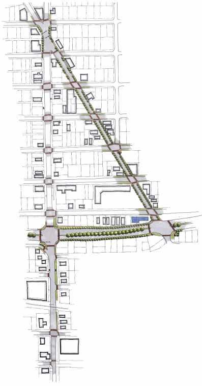
27 The Graphic Plan The following three pages illustrate the proposed Town Center Vision projects in graphic form. The plan is meant to provide a conceptual and legible image for visualizing the proposed improvements. It was prepared at a standard scale of 1 inch equals 100 feet, but reproduction may alter this scale slightly. This scale is appropriate for developing a feel for plan elements and for beginning to define improvements, but it is not appropriate for detailed design. This plan should be used by the layperson to better understand the improvements described above with the understanding that a more detailed design will be accomplished in Phase II of the Town Center Program. The Phase II consultant should use the plan as a guide reference in developing construction drawings for the corridor. 23
28

29
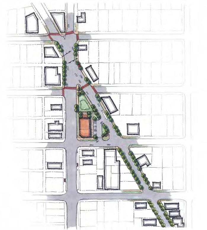
30
31 4 Future Visions The following projects and improvements are listed outside of the primary group of projects because of their dependency on outside elements, budget constraints, or unknown variables to reach completion. They are important projects that were identified and discussed in the workshops, and they should continue to be considered for coordination, funding, design, and implementation. RIGHT-OF-WAY PROJECTS: Roadway Infrastructure Improvements Workshop participants placed drainage improvements high on their list and there was almost universal agreement in wanting to locate overhead utilities underground. Both are related projects and can be best accomplished at the same time. However, the cost for doing either is extremely high. Available Town Center funds would not cover the replacement of either of these projects even if they were the only ones recommended. Because Town Center funds cannot cover the cost of significant infrastructure improvements, they are much better allocated to those improvements outlined in the previous section that will have a positive visual impact and that will improve the pedestrian access to the Town Center. Fortunately, the Better Jacksonville Plan program for Myrtle Avenue calls for infrastructure improvements. While it is not stated yet what specific infrastructure improvements will be made, it is likely to provide for drainage improvements, similar to the Myrtle Avenue improvement project south of 15th Street. To satisfy the need for drainage improvements within the Town Center District, Moncrief Road also needs to be considered for infrastructure upgrades. To speed up the process of designating Moncrief Road as a City of Jacksonville improvement project, whether through the Better Jacksonville Plan or other city program, MANIA and Northwest Jacksonville CDC should create a coordinated subcommittee to spearhead infrastructure improvements for the corridor. The committee should solicit support from their City Council District 8 representative (Hon. Gwen Yates at the time of this writing) and create an active dialogue with the Public Works department to improve the priority of this project. The committee should solicit support from area business leaders, the mayor s office, and other interested parties to assist with the cost and scheduling of this effort. This subcommittee should also be responsible for coordinating the burying of overhead utilities as part of the infrastructure programs for both Myrtle and Moncrief. Underground Utilities Workshop participants unanimously agreed that locating overhead utilities underground would improve the aesthetics of the corridor. Aging utility poles could be removed, sidewalk space expanded, ugly wires buried from sight, and trees no longer required to be severely pruned, but as mentioned previously, this is an expensive process when not coupled with other infrastructure improvements. JEA, as the electrical utility provider, has indicated in word and practice a desire to put their wires underground, and this is their general preference with new development. Burying existing wires in 27
32 an older neighborhood, however, presents major challenges. The technology exists to jack and bore the wires underground without disturbing the surface, but it is an expensive process. Additionally, other service providers that share the overhead lines with JEA, such as telephone and cable, must also agree with this direction for it to occur. It is not clear who would be responsible for paying for this service as no one party feels they should assume the full cost. Nevertheless, it remains part of the long-term vision for the community. Space for a traffic circle at the intersection of Myrtle Avenue and Moncrief Road is very limited. The shape of the intersection is determined by the acute angle of the intersecting roadways that results in an hourglass shape with a relatively narrow center. To locate a traffic circle appropriately at the center would necessitate expanding the right-of-way through private property acquisition. At least four of the adjacent properties would be impacted, with demolition of some or all of the property buildings, most notably the adjacent fire station Number 18 built in In other areas of town, JEA has participated in burying their overhead lines when major road or utility work has occurred. Repair or replacement of existing underground utilities, like storm sewers or water lines, would be a prime example of projects that would require major roadway construction ideal for relocating utilities underground. As stated before, the most likely scenario for procuring underground corridor utilities would be through coordination with the next major roadway construction. For Myrtle Avenue, this would be through the Better Jacksonville Plan program. The engineering study for that project would be the best period for the recommended infrastructure subcommittee to coordinate utility burial with those agencies involved, primarily JEA and Public Works. That effort is scheduled to begin in early Traffic Circle Workshop participants as well as the Neighborhood Action Plan recommended a traffic circle (roundabout) to be sited in the Myrtle Avenue and Moncrief Road intersection. This feature would add significant visual interest to the area and would serve as a memorable entry feature to the Town Center district. However, there are several concerns that the Project Team has with this proposal. Another negative consideration is the familiarity of the local community with negotiating a traffic circle. Traffic circles are still uncommon in Jacksonville, despite their growing popularity, and most residents are unfamiliar with their use. Because of the irregular shape of the intersection, negotiating a traffic circle might prove challenging at best. With these considerations in mind, the Project Team did not feel this intersection would be an appropriate location for a traffic circle. Community Center Workshop participants indicated a need for a local community center and gathering place within walking distance of area residents. The fact that the City of Jacksonville owns three vacant parcels at the heart of the Town Center represents an ideal opportunity for public use of this land. The Project Team recommends that a committee be formed jointly or separately by MANIA and Northwest Jacksonville CDC to address the feasibility of converting this land to a community center and to garner support for funding through their district council representative, local businesses and institutions, and through funding programs described in the next section. If support is favorable, the committee could, as a next step, solicit professional design alternatives to enable an accurate cost estimate for a new facility and to generate additional support through creating a development vision. Another significant advantage of converting these vacant parcels to commu- 28

33 nity use is that the Project Team recommends a neighborhood park be constructed on the adjacent privately-owned parcel at the point of the intersection. PRIVATE PROPERTY PROJECTS: Neighborhood Park The need for a community park was strongly voiced by workshop participants. The triangularshaped parcel located at the intersection of Myrtle Avenue and Moncrief Road should be strongly considered for purchase and conversion to a neighborhood park. This recommendation is in line with the Neighborhood Action Plan for the 29th and Chase area. This proposed location would create a very visible park while creating a pleasant north entry feature to the Town Center. This location is also adjacent to three city-owned parcels recommended for use as a community center. Consolidation of this small block would create an ideal location at the heart of the Town Center for a civic amenity. The parcel has most recently been used as a corner filling station but is currently vacant. The Project Team recommends that this property be purchased by the City of Jacksonville through assistance by MANIA and Northwest Jacksonville CDC for conversion to a city owned and operated park. The current market value is listed by the city s property appraiser at $44,728, and its most recent sale price was $167,000 in The Project Team has prepared a development concept for the park as part of the Vision Plan. The cost for proposed improvements to the park as listed in the previous section would be $100,000. To make this project more feasible for the city, the Project Team recommends that MANIA and Northwest Jacksonville CDC seek additional funding through one or more of the resources listed at the end of Section 5. Building Improvements Buildings are one of the primary elements defining the Town Center corridor. Their architectural style, history, arrangement, and use create a sense of place more than any other single corridor feature. Buildings older than 40 or 50 years (from the date of this report) were built in an era when raw materials, especially lumber, were of a much higher quality. Craftsmanship had a higher social value at that time, and attention to form and detail was important. Also significant is the location of these buildings; they were typically built with storefronts facing the primary road and close to the right-of-way. This placement is in contrast with development trends that evolved with the automobile and Plan concept for community center and neighborhood park shifted priorities toward near Myrtle Avenue and Moncrief Road intersection parking convenience, resulting in buildings being pushed toward the rear of lots. The placement of buildings close to the road is a visually defining element that is desirable from a pedestrian point of view. Buildings from the older era are visually apparent and an immediate indicator of a historic place. For these reasons they are usually worth preserving and renovating. The following recommendations are among the most important for creating an appealing Town Center: 29
34 Awnings for commercial storefronts that abut the right-of-way. Building awnings add visual interest as well as much needed shelter from the elements, especially at building entrances. Awnings that project are preferable over ones that hang vertically. Awnings should extend a minimum of 4 feet to provide adequate shelter for pedestrians. Restoration of storefront windows. Traditional storefront windows should be preserved and alteration with metal frames or excessive paint should be avoided. Removal of burglar bars on windows. Invisible security measures, such as automated electrical systems, should be implemented in place of metal window burglar bars that are visually unappealing and promote the perception that crime is a problem in the area. Traditional door replacement. Traditional building doors are wood with possibly a glass insert. Replacement doors if made of modern materials such as metal or fiberglass should be manufactured to look historically correct or at least sympathetic to the prevailing historic theme. 30 Do not paint exposed brick. Many of the storefronts along the corridor are unpainted brick. They should remain unpainted to preserve the original appearance. Painting of brick is most often irreversible and should be avoided whenever possible.
35 5 Implementing the Vision The previous two sections describe many projects that make up the overall Vision for Myrtle and Moncrief. Those projects described in Section 3 qualify for Phase II funding and fit within the established budget. At least some of the Vision elements will be realized within a relatively short time, probably 2 to 4 years from the date of this report. Nevertheless, these measures alone are not enough to ensure that Myrtle and Moncrief will grow into the energetic, pedestrian-oriented community envisioned by the workshop participants. There are still several implementation measures that MANIA and NJCDC and the community need to consider. Fortunately, a model exists that provides an established framework on which MANIA and NJCDC could base their own Town Center initiative. The Florida Main Street Approach The Town Center corridor that is the heart of Myrtle and Moncrief functions similarly to a small town Main Street. In this regard, we feel the Florida Main Street program provides a useful model for developing implementation strategies. Florida Main Street is a program of the Department of State, Division of Historical Resources, Bureau of Historic Preservation. The program provides training and technical assistance to local Florida Main Street programs in accordance with the National Main Street Center Four Point Approach and with assistance from the Nation Main Street Center. Design improvements alone will not bring about meaningful change; effective marketing, a strong organizational base and solid economic development strategies are all necessary to reverse the cycle of decay from which many downtowns suffer and to sustain preservation activity. (Florida Main Street) Design Design involves improving the downtown s image by enhancing its physical appearance not just the appearance of buildings, but also that of street lights, window displays, parking areas, signs, sidewalks, promotional materials and all other elements that convey a visual message about the downtown and what it has to offer. (Florida Main Street) Of the four points, design is the one most frequently addressed in this report. Through this study and its subsequent Town Center phases, major design initiatives will be implemented. There remain, however, other important issues that need to be addressed. Develop a Handout MANIA and Northwest Jacksonville CDC should design a handout dedicated to outlining Vision goals and progress to date, as well as solicit involvement and input. This handout would be used as a promotional tool. Form a Subcommittee Dedicated to Future Programming. Projects listed in Section 4 are not funded under the City s Town Center Program. A subcommittee should be formed that will be responsible for coordination with Parks and Recreation, the City Council representative, the Planning and Development Department, area business representatives, and other stakeholders affected by the proposed project(s). Additionally, this group should identify alternative funding sources to create more development options. 31
36 Organization Organization means building consensus and cooperation among the groups that play roles in downtown. Many individuals have a stake in the economic viability of the downtown, including: bankers, property owners, city and county officials, merchants, downtown residents, professionals, chamber of commerce representatives, local industries, civic groups, historic societies, schools, consumers, real estate agents, and local media. (Florida Main Street) Form a Steering Committee. Organization is at the heart of Main Street success. Main Street programs always have a dedicated manager. Often this is a full-time paid position. MANIA and NJCDC, as the sponsoring groups, are already a dedicated organizations. To ensure that needs specific to this vision are met, a Town Center steering committee should be formed to oversee the implementation of this Vision. The steering committee would be responsible for enacting the other three points of the program. Form a Local Merchants Organization. Because local business owners are part of this process and can benefit greatly from its success, a local merchants group could be formed that can represent its significant interests. Promotion Promotion involves marketing the area s unique characteristics to shoppers, investors, new businesses, residents, tourists, and others. Effective promotion creates a positive image for the area through retail promotional activity, special events and ongoing programs to build a positive image of the community. Involve Local Merchants. To gain the support necessary to enact this Vision, the program and Myrtle and Moncrief itself must be actively promoted. The local merchants need to be a part of this promotion effort and involved in its organization. It is important that promotion planners understand merchant needs such as access and visibility, and it is just as important for business owners to understand that promotion often involves extra effort, such as extending store hours at certain times. Create a New Event. Regular events are an excellent means of generating interest and activity for a Town Center. MANIA and NJCDC should create at least one new event that is unique to the area that would attract local residents as well as people from around the city. Dade City Main Street used a two-event-per-year program to effectively build support for Main Street and at the same time create new local traditions. They created one event to be family-oriented, inexpensive, and fun (a Halloween carnival) and one event that was purely for the merchants (a Christmas walk). Both events require a great deal of organization but have resulted in a very successful redevelopment for their Town Center. Economic Restructuring Economic restructuring means strengthening the existing economic base of the downtown while diversifying it. Economic restructuring activities include helping existing downtown businesses expand, recruiting new businesses to provide a balanced mix, converting unused space into productive property and sharpening the competitiveness of downtown merchants. By strengthening the downtown s economy, communities are able to support the ongoing use of historic commercial buildings, preserving unique community assets. (Florida Main Street) Conduct a Market Study. A market study would examine in detail the economic and demographic conditions specific to Myrtle and Moncrief. Initial efforts might include identifying sources of funding to pay for a professional analysis. Alternatively, MANIA and NJCDC could conduct their own market study, using volunteers to research available data and draw conclusions regarding the current and potential conditions of the environment. In either case, this would be a significant first effort toward economic restructuring, lending the necessary information to make informed decisions. 32
37 Town Center Program Phase II With the completion of this report, the Myrtle and Moncrief community is eligible to apply for Phase II funding through the City s Town Center Program. MANIA and Northwest Jacksonville CDC, as the sponsoring agents for Phase I, are the logical choices to make the Phase II application. The types of improvements found in Section 3 of this report and their estimated costs can serve as the guide for the Phase II application. The Phase II effort would include continued community input as well as coordination with the City and other affected agencies for construction details. Other Funding Opportunities The Project Team has identified several funding opportunities that could be used by MANIA and Northwest Jacksonville CDC (or other viable party) to help implement the projects described earlier in Section 4. The following list is meant to be a starting point; numerous other opportunities exist and may provide the best fit for implementing one or more of these projects. City of Jacksonville The following City programs are accessible but often competitive, requiring the sponsoring agent to be organized and persistent as recommended earlier. Nevertheless, the projects outlined in this report as community building initiatives are ideal candidates for funding from many of these sources. The following list is meant to be a starting point, as other opportunities exist and may provide a better fit for implementing one or more of these projects. JEDC Facade Program This program is designed to assist business owners to improve their building facades. Small Business Development Initiative Program This program is aimed at small and start-up businesses and provides low interest loans to qualified applicants for up to 30% of the project cost, and not to exceed $250,000. Mayor s Neighborhood Matching Grants Program The Mayor s Neighborhood Matching Grants (MNMG) Program makes awards of up to $5,000 to specific neighborhood projects that build relationships and enhance the community. As part of the city s continuing efforts to improve and strengthen Jacksonville neighborhoods, the Mayor will propose to the City Council during the Fiscal Year budget cycle an appropriation of $250,000 for projects that promote stronger, healthier neighborhoods. If authorized, the funds will become available October 1, Any neighborhood association, civic organization or community group that has been in existence for at least six months and is located in Duval County is eligible to submit an application. ( The Matching Grant Program offers neighborhood organizations the opportunity to initiate and implement smaller scale projects and manage the projects themselves. This program may offer opportunities to develop some of the smaller projects identified in this report or pieces of larger ones. Local information about the program can be obtained at or on-line at Community Development Block Grant The Community Development Block Grant (CDBG) is an entitlement grant awarded to the City of Jacksonville through the U.S. Department of Housing and Urban Development (U.S. HUD) that is based upon need factors including population, income, unemployment level and housing conditions. CDBG grants are to be used for a wide range of housing and community development activities directed toward neighborhood revitalization, economic development and improved community facilities and services, and must 33
38 give maximum feasible priority to activities that will benefit low-and moderate-income persons or aid in the prevention or elimination of slums or blight. Funds may also be used to meet other community development needs that present a serious and immediate threat to the health or welfare of the community. ( Some of the projects outlined in this report could be eligible for CDBG funding. Local information about the program can be obtained at or on-line at Historic Properties In November 1992, the State of Florida authorized local governments to provide a partial tax exemption on historic properties. The City of Jacksonville approved an ad valorem tax exemption for locally designated properties that undergo a substantial rehabilitation. ( To be eligible for Historic Property benefits, the property or area must have a historic designation. Properties can seek landmark status at the local level or apply for a listing on the National Register of Historic Properties through the Trust for Historic Preservation. The Myrtle and Moncrief neighborhood is not part of an established historic district; therefore, each building or property would apply individually. Tree Protection and Related Expenses Trust Fund The Jacksonville City Council approved the creation of the Tree Protection and Related Expenses Trust Fund to provide for the replacement of removed protected trees within the public right-of-way and for their establishment and care. Contributions to the fund come primarily from property owners, both private and public, that remove protected trees (as defined by the ordinance) and elect to pay for each protected tree removed (at $108 per caliper inch for 2004), rather than replace them with new trees according to the ordinance requirements. The proposed trees in this report are located in the right-of-way and may be eligible for funding through the Tree Protection and Related Expenses Trust Fund. State of Florida The following resources and contact information are listed for potential state funding and assistance. They are listed in order of applicability to this Vision report and those with greatest correlation are described more fully. Florida Department of Transportation The current Transportation Enhancement Program (TEP) provides enhancement funds for improvements that are recommended in this report as well as other improvements not specifically addressed, such as provisions for bike lanes. ISTEA Enhancement Program Transportation enhancement projects, including bike and pedestrian trails. Robert Crimm (850) Suwannee Street Tallahassee, Florida The Transportation Enhancement Program (TEP) is a federal program administered by the Florida Department of Transportation (FDOT). TEP guidance and direction are provided by the Environmental Management Office, whereas the selection and implementation of most enhancement projects are handled by the FDOT District Offices with input from Metropolitan Planning Organizations or County Commissions. Funding for transportation enhancement projects is provided by the Federal Highway Administration (FHWA) through the Federal Transportation Equity Act for the 21st Century (TEA-21). This funding is intended for projects or features that go beyond what has been customarily provided with transportation improvements. This program is for projects that are related to the transportation system but are beyond what is required through normal mitigation or routinely provided features is transportation improvements. TEP is not a grant program, rather projects are undertaken by project sponsors, and eligible costs are reimbursed. 34
39 TEP Activities Defined - 1. Provision of facilities for pedestrians and bicycles. 2. Provision of safety and educational activities for pedestrians and bicyclists. 3. Acquisition of scenic easements and scenic or historic sites. 4. Scenic or historic highway programs (including the provision of tourist and welcome center facilities). 5. Landscaping and other scenic beautification. 6. Historic preservation. 7. Rehabilitation and operation of historic transportation buildings, structures, or facilities (including historic railroad facilities and canals). 8. Preservation of abandoned railway corridors (including the conversion and use thereof for pedestrian or bicycle trails). 9. Control and removal of outdoor advertising. 10. Archaeological planning and research. 11. Environmental mitigation to address water pollution due to highway runoff or reduce vehiclecaused wildlife mortality while maintaining habitat connectivity. 12. Establishment of transportation museums. ( Department of Community Affairs Florida Communities Trust This program could provide another funding mechanism for acquiring the land for the proposed park described in Section 4. Florida Communities Trust (FCT) is a state land acquisition grant program housed at the Florida Department of Community Affairs. FCT provides funding to local governments and eligible nonprofit environmental organizations for acquisition of community-based parks, open space and greenways that further outdoor recreation and natural resource protection needs identified in local government comprehensive plans. ( Department of State State Historic Preservation Grants-in-Aid Program Historic and archaeological site identification, preservation, restoration and education. Fred Gaske (850) South Bronough Street Tallahassee, Florida Historical Museums Grants-In-Aid Program Development of exhibits on Florida history. David Gregory (850) The Old Capitol, Room B South Monroe Street Tallahassee, Florida Cultural Facilities Program Funding for acquisition, construction and renovation of cultural facilities. Don Blancett (850) DeSoto Park Tallahassee, Florida Challenge Grant Program Funding to support unique or innovative cultural projects. Dr. Gaylen Phillips (850) DeSoto Park Tallahassee, Florida Janice Browning (850) Shumard Oak Boulevard Tallahassee, Florida
40 6 Maintaining the Vision Maintenance is a significant issue determining the success or failure of proposed improvements, whether on public or private land. Maintenance represents care, and the care of a place is visually apparent even from a speeding car. The degree of care offered to a place, whether it is a building or a landscape, is usually a factor of time and money, but it also depends greatly on varying attitudes about what is visually acceptable by a community. The broad design measures recommended in this report are prepared with the benefit of training and expertise. The use of certain materials and their arrangement will create a more ordered and appealing environment, even with little continual maintenance. Where a more manicured appearance is desired, supplemental maintenance will be required. The recommendations below are aimed at providing the necessary coordination and practice to achieve a higher quality appearance and longer lasting product for the proposed corridor improvements. Partnerships With regard to public right-of-ways and parks, the immediate solution for elevated maintenance is the creation of partnerships. Partnerships between public and private entities many times allow for a win-win situation, with each often getting what they want. Public agencies aim to please the community while maintaining a budget; private entities desire a higher degree of control over the look and upkeep of their shared environment. In many partnerships, all or a percentage of the public maintenance budget is allotted to the private entity for maintenance purposes under a contract clearly stating minimum requirements. In some cases, the established public budget is adequate to fund the desired maintenance when supplemented with volunteer labor, donations, and other resources not available to the public entity. The City of Jacksonville is the public agency that maintains jurisdiction over the right-of-way along Myrtle Avenue and Moncrief Road. FDOT maintains jurisdiction over the right-of-way along MLK Parkway. To move this Vision forward, it is important for MANIA and Northwest Jacksonville CDC to coordinate the implementation goals of this plan with the City and FDOT. Ultimately, a contract may be required between all public agencies, the residents, and the businesses to achieve consistent maintenance along each corridor. Landscaping Landscape plants are one of the most visible clues of the degree of maintenance an area or place undertakes. Basic landscape maintenance is relatively inexpensive when compared to the cost of roadway, infrastructure, utility, building, or other maintenance efforts. Typical landscape routines for public sector entities are limited to regular mowing with occasional edging and trimming. Extended Maintenance Period The critical maintenance period for landscape plants is the first year following installation. Typical City of Jacksonville landscape contracts require a 90-day maintenance period. This is not long enough to ensure proper plant establishment. The duration of maintenance through establishment is further necessitated when there is no automated irrigation system. None of the landscape improvements in this report are envisioned 36
41 with or budgeted for an automated irrigation system. Therefore, the Project Team recommends that installation contracts include an extended maintenance program for a minimum of one year to allow better establishment of new plants. General Maintenance Practices General maintenance practices should conform to industry standards. While the plants recommended in this report are hardy and should do well with little attention once established, they will grow faster, be healthier, and look much better with regular attendance. Plants should be fertilized annually, according to their specific need. Plants should be inspected annually for pests or disease, and pesticides should be applied as needed to infested or diseased plants. Pruning should be accomplished only by licensed personnel and according to ANSI A-300 pruning standards. Pruning should only be performed to remove dead or low-hanging branches. Crape myrtles especially should not be cut back severely from the top but instead allowed to achieve a natural, small tree form. Weeds should be removed at least twice per year during establishment, and after shrubs and ground covers have been established, on an as needed basis. To limit weed intrusion, an annual application of mulch and pre-emergent herbicide is recommended annually for all planting beds. Pine straw and pine bark are recommended mulch selections. Cypress bark should be avoided as a nonrenewable resource and colored mulches avoided due to their artificial appearance. Light Posts and Signal Posts Light and signal posts should be inspected annually and damage reported to JEA. Repainting should occur when fading or peeling is visible. Buildings Older buildings such as the ones along the Town Center corridor require continual maintenance. Facade treatments, storefronts and street-facing, publicly visible features are of concern in this report. Exposed wood materials should be kept painted, stained, or treated to maintain the quality of the wood and a well-kept appearance. Jacksonville s climatic conditions necessitate repainting on a five-year average. Faded or torn awnings, or other cloth or plastic material mounted to the facade, should be replaced with new material. Property owners should keep sidewalks that are their responsibility in good repair and clean of all litter and debris to maintain a well-kept appearance. Graffiti should be removed immediately from sidewalks or building walls. Graffiti that lingers signals to residents and vandals that the neighborhood does not care, while prompt removal has the opposite effect. Products are available for this purpose, and standard oven cleaner apparently works well. 37 Sidewalks, Crosswalks, and Seating Areas Paved areas outside of the roadway itself need to be inspected annually for cracking, settlement, and other conditions that pose a hazard to pedestrians. Weeds that appear in cracks and spaces should be spot-treated as needed with an herbicide.
42 7 Final Recommendations As a final measure of ensuring the ongoing realization of the Myrtle and Moncrief Town Center Vision, we offer the following recommendations: Overlay District During the workshops, participants discussed the value of creating an overlay district for all or part of the Myrtle and Moncrief study area. An overlay district would allow Myrtle and Moncrief property owners to develop written guidelines specific to the neighborhood and geared toward protection and promotion of its valuable assets. Guidelines would give greater understanding, form, and direction to renovation and new development efforts. Establishment of a district could also give an added measure of protection to historic properties. Initially, there are two primary areas of concern discussed in the workshops: commercial signs and commercial building renovation. Commercial Signs Signs along the corridor, including commercial signs and transportation signs, have significant visual impact. Because transportation signs must maintain a universality for effectiveness, the commercial signs along the corridor should be the primary focus. As part of the overlay guidelines, MANIA and NJCDC should develop sign guidelines specific to Myrtle and Moncrief. Sign guidelines would aid new businesses attracted to the Town Center through this initiative by developing a consistent approach. Guidelines would also aid existing business owners in communicating the long-term objectives of the program and, while not obligating them to change or replace their current signs, at least inform them of the Vision. Sign attributes such as size, location, height, color, shape, and material should be considered. Architectural Guidelines As with sign guidelines, MANIA and Northwest Jacksonville CDC should create architectural guidelines for the overlay district, specific to the needs and Vision of the Myrtle and Moncrief Town Center. Such guidelines would serve to assist business owners in providing renovation standards, while also boosting investor confidence in the strength of local commitment to the Town Center Initiative. Architectural guidelines should initially address facade improvements as the most visible and public aspect of commercial buildings. General guidelines for facade improvements are offered in Section 4, but additional measures specific to the district should be developed. CPTED CPTED is the acronym for Crime Prevention Through Environmental Design. CPTED is defined as the proper design and effective use of the built environment that can lead to a reduction in the fear and incidence of crime and an improvement in the quality of life. CPTED addresses crime problems through controlling the environment. CPTED is based on these three overlapping strategies: 1. Natural Surveillance - The placement and design or physical features to maximize visibility. This includes building orientation, windows, entrances and exits, parking lots, walkways, guard gates, landscape trees and shrubs, fences or walls, signage and any other physical obstruction. 38
43 2. Natural Access Control - The use of sidewalks, pavement, lighting and landscaping to clearly guide the public to and from entrances and exits. Also, the use of fences, walls or landscaping to prevent and/or discourage public access to or from dark and/or unmonitored areas. 3. Territorial Reinforcement - The use of pavement treatments, landscaping, art, signage, screening and fences to define and outline ownership or property. Program Goals The goal of CPTED is to reduce opportunities for crime that may be inherent in the design of structures or in the design of neighborhoods. The goal is accomplished through the involvement of CPTED trained law enforcement officers in the planning, development, and design review of community projects. How does CPTED impact me? CPTED impacts each citizen by increasing safety, promoting secure environments and improving the appearance of neighborhoods and public amenities. CPTED improves existing services by working with neighborhoods, businesses, community groups and law enforcement. ( Called septed, this City of Jacksonville s Sheriff s Office (JSO) program from the JSO helps communities identify crime-causing elements in the environment and solutions to rectify them. JSO has designated officers specially trained to communicate this process to the community and to find solutions specific to the area. Many of their observations are intriguing and escape notice by the layperson. Often it is little changes to the environment that make big differences in reducing crime. As this is a free service, we strongly recommend that MANIA and Northwest Jacksonville CDC coordinate a CPTED survey through the JSO. Code Enforcement Workshop participants cited greater code enforcement as a high priority to ensure a cleaner and more appealing corridor. Significant problems noted by participants included: Private property maintenance, especially concerning deteriorating residences and yard maintenance historic preservation code violations trash removal from the right-of-way cars parked in front yards vandalism and graffiti drugs and prostitution The Jacksonville Ordinance Code provides for minimum acceptable social practices to maintain a consistent appearance and pleasant, healthy living environment. Citizens may register complaints and violations directly with the City through City Link and the C.A.R.E. system. City Link 117 W. Duval Street Suite M-150, City Hall Jacksonville, FL (904) or 630CITY@coj.net Other resources to help in code enforcement include: JaxPride jaxpride@fcol.com 39 Officer Laurie Dill (904) JSO Community Affairs Division 501 East Bay Street, Room 204 Jacksonville, Florida 32202

44 8 Conclusion The Myrtle and Moncrief commercial district has a viable opportunity through the City s Town Center Initiative to restore and revitalize its character, provide better, safer shopping, service, and entertainment alternatives for area residents, and create a more meaningful and aesthetically pleasing environment. This report represents the first step in effecting those changes. The Vision we have defined for Myrtle Avenue and Moncrief Road through data collection, Vision concepts, and implementation recommendations is the fundamental step required to move forward. This report meets Town Center Program Phase II funding requirements and contains the necessary ingredients to steer development of construction drawings; however, Phase I recipients are not guaranteed Phase II funding through the program. If selected by the City for Phase II funding, the Phase II design consultant should use this report as a guide to identify the primary themes and recommendations we have developed for Myrtle and Moncrief. The Vision concept illustrations provided in this report are meant to be used for developing construction drawings. Prepared at a workable scale, they are reasonably accurate and should be used by the Phase II consultant as an overlay once a more accurate base plan is developed. Where changes must occur due to unforeseen circumstances, the Phase II consultant should make needed adjustments while keeping the theme of the Vision in mind. MANIA and Northwest Jacksonville CDC have taken a strong first step in pursuing this program to create a revitalized Myrtle and Moncrief Town Center. The Vision we have developed in this report responds directly to the needs and desires of the community. Through the fulfillment of this Vision, Myrtle and Moncrief will become a more successful community, recognized as a unique and desirable place within the greater city of Jacksonville. 40
3 Focusing the Vision Following the second workshop, the Project
 3 Focusing the Vision Following the second workshop, the Project Team undertook the task of refining the Vision developed during the workshops. The final plan addresses participant desires while incorporating
Town Center Vision Plan. Murray Hill. City of Jacksonville. Planning and Development Department. Town Center Program Phase I Initiative
 Town Center Vision Plan Murray Hill City of Jacksonville Planning and Development Department Town Center Program Phase 1 Initiative Town Center Vision Plan Murray Hill City of Jacksonville Planning and
Table of Contents. Elm Avenue Improvement Plan City of Waco, Texas. Introduction 1. Existing Context 1 Figure 1 2.
 Table of Contents Introduction 1 Existing Context 1 Figure 1 2 Plan Guidelines 3 Future Urban Form 4 The West-End 4 Main Street 6 The East-End 7 Figure 2 9 Public Improvement Recommendations 7 General
Town Center Vision Plan 103 rd Street
 Town Center Vision Plan 103 rd Street City of Jacksonville Planning and Development Department Town Center Program Phase I Initiative November 2004 Acknowledgments This document was prepared for the City
CHAPTER 3 VISION, GOALS, & PLANNING PRINCIPLES. City of Greensburg Comprehensive Plan. Introduction. Vision Statement. Growth Management Goals.
 CHAPTER 3 VISION, GOALS, & PLANNING PRINCIPLES Introduction The Greensburg Comprehensive Plan is intended as a working community document. A combination of long and short-term goals, this document is intended
GREENING THE BOULEVARD Master Plan Concepts for Venice Boulevard between Lincoln and Sawtelle
 GREENING THE BOULEVARD Katherine Spitz Associates Inc. 4212½ Glencoe Avenue Marina Del Rey, CA 90292 310 574 4460 Fax 574 4462 January 2008 Table of Contents Overview Proposed Design Improvements Illustration
3. VISION AND GOALS. Vision Statement. Goals, Objectives and Policies
 Vision Statement Queen Creek s interconnected network of parks, trails, open spaces and recreation opportunities provide safe and diverse activities and programs that sustain its unique, small town, equestrian
The Lower SaLuda Greenway
 The Lower SaLuda Greenway InITIaTIve a FLourIShInG Greenway. a hub For economic GrowTh. a ConneCTIon BeTween CoMMunITIeS. In April 2017 the Michael J. Mungo Foundation and Lexington County commissioned
City of Farmington. Downtown Plan. Amendment to the 1998 Master Plan Adopted October 11, 2004
 City of Farmington Amendment to the 1998 Master Plan Adopted October 11, 2004 Introduction Planning Background 1 Scope and Components of the Plan Amendment 2 Concept Introduction 3 Plan Concepts 3 Conceptual
CITY OF CHARLOTTESVILLE, VIRGINIA CITY COUNCIL AGENDA
 CITY OF CHARLOTTESVILLE, VIRGINIA CITY COUNCIL AGENDA Agenda Date: December 16, 2013 Action Required: Adoption of Resolution Presenter: Staff Contacts: Title: James E. Tolbert, AICP, Director of NDS James
Volume 2: Implementation Plan
 Volume 2: Implementation Plan February 25 th 2002 Implementation Introduction This document outlines the steps that should be taken to implement the Washington Heights Neighborhood Plan. The City Council
SDOT DPD. SDOT Director s Rule DPD Director s Rule DCLU DR SED DR of 7 CITY OF SEATTLE
 SDOT SDOT Director s Rule 2-07 DPD Applicant: CITY OF SEATTLE Page 1 of 7 Supersedes: DCLU DR 11-93 SED DR 93-4 Seattle Department of Transportation (SDOT) Department of Planning and Development (DPD)
Town Center Vision Plan Venetia
 Town Center Vision Plan Venetia City of Jacksonville Planning and Development Department Town Center Program Phase I Initiative February 2005 Acknowledgments This document was prepared for the City of
Town Center Vision Plan Lakewood
 Town Center Vision Plan Lakewood City of Jacksonville Planning and Development Department Town Center Program Phase I Initiative June 2006 Acknowledgments This document was prepared for the City of Jacksonville
Policies and Code Intent Sections Related to Town Center
 Policies and Code Intent Sections Related to Town Center The Town Center Vision is scattered throughout the Comprehensive Plan, development code and the 1994 Town Center Plan. What follows are sections
ARLINGTON COUNTY, VIRGINIA
 ARLINGTON COUNTY, VIRGINIA County Board Agenda Item Meeting October 15, 2005 DATE: September 28, 2005 SUBJECT: Request to Advertise the adoption of the 2005 Clarendon Sector Plan C. M. RECOMMENDATION:
VEHICULAR AND PEDESTRIAN CIRCULATION
 This perspective sketch communicates the intended character and quality of a proposed streetscape design. Locate benches near a major intersection where people tend to gather. Seating and lighting provide
Implementation Guide Comprehensive Plan City of Allen
 Implementation Guide 2030 Comprehensive Plan City of Allen DRAFT 2015 Implementation Guide Allen 2030 Comprehensive Plan INTRODUCTION The Comprehensive Plan serves as a guide for the growth and development
The transportation system in a community is an
 7 TRANSPORTATION The transportation system in a community is an important factor contributing to the quality of life of the residents. Without a sound transportation system to bring both goods and patrons
Carlsbad Village Redevelopment Concept Summary of Features
 Carlsbad Village Redevelopment Concept Summary of Features Calthorpe Associates November 5, 2003 The Redevelopment Concept illustrates a vision for the future of Carlsbad Village. The overall vision of
Scope of Services. River Oaks Boulevard (SH 183) Corridor Master Plan
 Corridor Master Plan") Scope of Services River Oaks Boulevard (SH 183) Corridor Master Plan PROJECT AREA The project area consists of the River Oaks Boulevard (SH 183) corridor bounded by SH 199 at the northern end and the Trinity
Scope of Services River Oaks Boulevard (SH 183) Corridor Master Plan PROJECT AREA The project area consists of the River Oaks Boulevard (SH 183) corridor bounded by SH 199 at the northern end and the Trinity
This Review Is Divided Into Two Phases:
 Semiahmoo Town Centre Review The purpose of this review: To review the Semiahmoo Town Centre Concept Plan, originally approved in 1993, to ensure that this centre will continue to serve the needs of South
CHAPTER 7: VISION AND ACTION STATEMENTS. Noble 2025 Vision Statement
 CHAPTER 7: VISION AND ACTION STATEMENTS This chapter presents the vision, policy and action statements that transform the comprehensive planning study, an analysis of Noble s past, future trends and community
MEMORANDUM. DATE: March 15, Chairman and Members Community Redevelopment Agency. Leif J. Ahnell, C.P.A., C.G.F.O. Executive Director
 MEMORANDUM DATE: March 15, 2019 TO: FROM: Chairman and Members Community Redevelopment Agency Leif J. Ahnell, C.P.A., C.G.F.O. Executive Director SUBJECT: Camino Square, IDA No. CRP-16-02, located at 171
Urban Planning and Land Use
 Urban Planning and Land Use 701 North 7 th Street, Room 423 Phone: (913) 573-5750 Kansas City, Kansas 66101 Fax: (913) 573-5796 Email: planninginfo@wycokck.org www.wycokck.org/planning To: From: City Planning
Johnson Street Bridge Public Realm Update
 Johnson Street Bridge Public Realm Update August 20, 2015 Background Johnson Street Bridge Replacement Project impacts a diverse range of stakeholders In addition to a new bridge, the project also includes
Beachside Redevelopment Committee
 Beachside Redevelopment Committee DRAFT FINAL RECOMMENDATIONS MARCH 22, 2018 This is a new slide 2 This is a new slide Table of Contents I. Introduction and Overview II. III. Community Improvements and
Burlington Enhancement Plan
 Burlington Enhancement Plan Community Presenta/on Burlington Residents Association East Tennessee Community Design Center The ETCDC is a non-profit that provides low cost, conceptual architectural and
3.0 master plan concept
 3.0 master plan concept 3.1 introduction The purpose of the Huron Church Road Master Plan Concept is to provide an overview of the Master Plan design process, identify preliminary streetscape installations
Town Center (part of the Comprehensive Plan)
") Town Center (part of the Comprehensive Plan) Mercer Island Town Center Looking North (2014) In 1994, a year-long process culminated in a set of design guidelines and code requirements for the Town Center
Town Center (part of the Comprehensive Plan) Mercer Island Town Center Looking North (2014) In 1994, a year-long process culminated in a set of design guidelines and code requirements for the Town Center
Sewanee Village + Request for Builder/Developer Proposals
 Sewanee Village + Request for Builder/Developer Proposals Contact: Frank X. Gladu Special Assistant to the Vice Chancellor University of the South 735 University Ave Version 3 Sewanee TN 37383 Released:
Atlanta BeltLine Subarea 3 Master Plan Update
 Atlanta BeltLine Subarea 3 Master Plan Update April 14, 2018 Workshop Meeting 1 22 miles, connecting 45 neighborhoods 22 MILES of transit 46 MILES of streetscapes and complete streets 33 MILES of urban
Danvers High Street I-1 District Study
 Danvers High Street I-1 District Study Presentation of Final Recommendations Planning Board Presentation June 26 th, 2018 1 Introductions Metropolitan Area Planning Council Sam Cleaves AICP, Principal
Welcome. Comprehensive Plan & Transportation Plan Open House November 7, 2012
 Welcome Comprehensive Plan & Transportation Plan Open House November 7, 2012 Agenda Proposed future land use plan Comprehensive Plan strategies Traffic forecasts Future traffic operations Possible future
Executive Summary. NY 7 / NY 2 Corridor
 Executive Summary NY 7 / NY 2 Corridor Transportation and Land Use Study December 2005 Prepared for: Town of Colonie Capital District Transportation Committee Prepared by: Introduction: Land use decisions
FDOT D4 Complete Streets
 FDOT D4 Complete Streets Context Sensitive Solutions Directs that complete street solutions will complement the context of the community. Collaborative approach to decision making, project development,
The open space system should provide connective elements, relate to natural resources, and enhance the suburban character of the landscape..
 The open space system should provide connective elements, relate to natural resources, and enhance the suburban character of the landscape.. Mixed-use and infill development should maintain or enhance
C. Westerly Creek Village & The Montview Corridor
 C. Westerly Creek Village & The VISION Community Vision When the goals of the city are achieved Westerly Creek Village, a distinctive community defined by Montview Boulevard and Westerly Creek, is a strong
Sheridan Boulevard S TAT I O N A R E A P L A N S H E R I D A N B O U L E VA R D S TAT I O N A R E A P L A N
 Sheridan Boulevard S TAT I O N A R E A P L A N 1 City of Lakewood Adopted November, 2006 S H E R I D A N B O U L E VA R D S TAT I O N A R E A P L A N The Vision The City of Lakewood s overall vision is
John M. Fleming Managing Director, Planning and City Planner. Old East Village Dundas Street Corridor Secondary Plan Draft Terms of Reference
 Report to Planning and Environment Committee To: From: Subject: Chair and Members Planning & Environment Committee John M. Fleming Managing Director, Planning and City Planner Old East Village Dundas Street
The Lincoln Neighborhood Corridor Plan. The LiNC
 October 1, 2014 Planning Commission Study Session The Lincoln Neighborhood Corridor Plan The LiNC Purpose of Tonight s Meeting Introduction to The LiNC Review of Existing Conditions and Community Identified
Lehigh Acres Land Development Regulations Community Planning Project
 Lehigh Acres Land Development Regulations Planning Effort Summary In July, 2010 Commissioner Frank Mann invited the Lehigh Acres community to start discussing how to achieve their recently adopted community
COMPLETE GREEN STREET CHECKLIST
 COMPLETE GREEN STREET CHECKLIST This document was developed to dissect the structure of an urban street and explore opportunities to make our streets more complete while also integrating green street strategies.
Port Lavaca Future Land Use
 Port Lavaca Future Land Use Introduction The City of Port Lavaca is beginning to see sustained growth, after many years of relative stable population. New single family homes, apartments, and businesses
Building Great Neighbourhoods. Strathcona
 Building Great Neighbourhoods Strathcona March 21, 2018 Becky Redford Project Manager, Planning & Design Building Great Neighbourhoods Integrated Infrastructure Services Welcome and Purpose To provide
TEMPLE MEDICAL & EDUCATION DISTRICT
 City of Temple, Texas TEMPLE MEDICAL & EDUCATION DISTRICT 1 Description. The City of Temple joined in partnership with key public and private entities to jointly promote education and medical activities
City of Bristol Route 6 Corridor Implementation Program
 City of Bristol Route 6 Corridor Implementation Program FITZGERALD & HALLIDAY, INC. Innovative Planning, Better Communities June 2017 Route 6 Corridor Plan IMPLEMENTATION PROGRAM The following Implementation
Denton. A. Downtown Task Force
 2 Public Involvement Early and ongoing public involvement was solicited so that the public had ample opportunity to help direct the DTIP s concepts and implementation strategies. The residents of Denton
Making TOD Work in the Heart of Suburban Sprawl
 Making TOD Work in the Heart of Suburban Sprawl Rocky Mountain Land Use Institute March 6, 2009 Speakers Ben Herman, FAICP, Principal Clarion Associates Darcie White, AICP, Principal Clarion Associates
4.1.3 LAND USE CATEGORIES
 4.1.3 LAND USE CATEGORIES a. City Center District The City Center District incorporates the existing character and mix of uses in downtown Belmont to encourage redevelopment and new development in keeping
Allen Street Civic District Redevelopment Area Plan Redevelopment Plan & Proposal State College Planning Commission State College Redevelopment
 Allen Street Civic District Redevelopment Area Plan Redevelopment Plan & Proposal State College Planning Commission State College Redevelopment Authority September 17, 2015 Discussion Points Overview of
A BLUEPRINT FOR BROCKTON A CITY-WIDE COMPREHENSIVE PLAN
 A BLUEPRINT FOR BROCKTON A CITY-WIDE COMPREHENSIVE PLAN Public Meeting October 2016 1 Plan Summary and Discussion Public Meeting May 4 2017 City of Brockton Bill Carpenter, Mayor Department of Planning
Status Update (2006 vs. Now) Citizen s Advisory Committee February Plan for Prosperity
 Citizen s Advisory Committee February Plan for Prosperity") Status Update (2006 vs. Now) Citizen s Advisory Committee February 2018 Plan for Prosperity 2000 2017 2000 2017 Gardnerville Population 6,000 5,760 5746 5,500 5,000 5,067 5,550 5,165 5,394 5,412 5,250
Status Update (2006 vs. Now) Citizen s Advisory Committee February 2018 Plan for Prosperity 2000 2017 2000 2017 Gardnerville Population 6,000 5,760 5746 5,500 5,000 5,067 5,550 5,165 5,394 5,412 5,250
PARTF Scoring System for Grants
 PARTF Scoring System for Grants The members of the N.C. Parks and Recreation Authority use the PARTF scoring system as one of several tools to select grant recipients. Please provide all of the information
100 Dix Drive Conceptual Master Plan. Wyatt Thompson, PLA, ASLA, Assistant Director Lindsay Stucki, Intern Park Planner
 100 Dix Drive Conceptual Master Plan Wyatt Thompson, PLA, ASLA, Assistant Director Lindsay Stucki, Intern Park Planner Final Draft Prepared August 2018 Introduction On September 20, 2016, the City of Manhattan
CHAPTER 7: Transportation, Mobility and Circulation
 AGLE AREA COMMUNITY Plan CHAPTER 7 CHAPTER 7: Transportation, Mobility and Circulation Transportation, Mobility and Circulation The purpose of the Transportation, Mobility and Circulation Chapter is to
EXISTING COMPREHENSIVE PLAN
 EXISTING COMPREHENSIVE PLAN Town Center Land Use Element: V. LAND USE POLICIES Town Center Mercer Island's business district vision as described in "Your Mercer Island Citizen-Designed Downtown" was an
Transportation. Strategies for Action
 Transportation A major priority for the Overlake Neighborhood is to develop a multimodal transportation system. To achieve this system, a balance has to be found among travel, circulation and access needs;
Wadsworth Boulevard S TAT I O N A R E A P L A N
 Wadsworth Boulevard S TAT I O N A R E A P L A N City of Lakewood Adopted November, 2006 The Vision The City of Lakewood s overall vision is to transform the area around the light rail station into a mixed-use
Design Guidelines: Brownsville Rd Façade Improvement Program
 : Brownsville Rd Façade Improvement Program Thank you for your interest in the Brownsville Rd Façade Improvement Program These Design Guidelines were prepared by Design Center Pittsburgh (DCP) for Economic
BUILDING SCALE AND SETBACKS 5 ELEMENTS:... 5 FAÇADES (COMMERCIAL/RESIDENTIAL) 5
 5") VISION STATEMENT 3 UTILIZATION OF THE GUIDELINES 3 IMPLEMENTATION 3 PROCEDURES FOR DESIGN REVIEW 3 LAND USE AND ZONING 4 LAND USE 4 ELEMENTS:... 4 ZONING 4 ELEMENTS:... 4 BUILDING SCALE AND SETBACKS 5
VISION STATEMENT 3 UTILIZATION OF THE GUIDELINES 3 IMPLEMENTATION 3 PROCEDURES FOR DESIGN REVIEW 3 LAND USE AND ZONING 4 LAND USE 4 ELEMENTS:... 4 ZONING 4 ELEMENTS:... 4 BUILDING SCALE AND SETBACKS 5
In surveys, Dallas residents say what they want to change most
 NEIGHBORHOODS ELEMENT In surveys, Dallas residents say what they want to change most in the city is its appearance they want it to look beautiful, with trees and pedestrian-friendly neighborhoods. The
DRAFT. October Wheaton. Design Guidelines
 October 2011 DRAFT Wheaton Design Guidelines 2 Draft - Design Guidelines - Wheaton Sector Plan Contents 04 Section 1: Introduction 06 Section 2: Context 08 Section 3: Design Guidelines 09 Goal 1: Create
SECTION TWO: Urban Design Concepts
 SECTION TWO: Urban Design Concepts The Gardnerville Plan for Prosperity shapes economic opportunities presented by regional growth. The Urban Design Concepts provide policies and concepts for land use,
Fifth and Detroit Street Design May 2017 Capital Improvements Committee. DOWNTOWN Street Design
 1 Fifth and Detroit Street Design May 2017 Capital Improvements Committee Agenda 2 Review Street Configuration Prior Meeting Review Outreach Synopsis Functional Street Design Refinements Curb Edge, Turning
Staff Report and Recommendation
 Community Planning and Development Planning Services 201 W. Colfax Ave., Dept. 205 Denver, CO 80202 p: 720.865.2915 f: 720.865.3052 www.denvergov.org/cpd TO: City Council Neighborhoods and Planning Committee
OVERVIEW OF PLANS FOR THE JEFFERSON COUNTY COUNTRYSIDE FARM In the Context of Quality Place Characteristics
 OVERVIEW OF PLANS FOR THE JEFFERSON COUNTY COUNTRYSIDE FARM In the Context of Quality Place Characteristics By Steve Grabow, Professor and Community Development Educator University of Wisconsin-Extension,
New York Avenue Streetscape and Trail Project Public Meeting #1 Summary
 New York Avenue Streetscape and Trail Project Public Meeting #1 Summary I. King Jordan Student Academic Center (SAC) Gallaudet University, Washington, DC February 23, 2017 Table of Contents 1.0 Introduction...
KASPER. City of Georgetown, Texas PUD Planned Unit Development. December 30, 2015 Revised January 27, 2016
 KASPER City of Georgetown, Texas PUD Planned Unit Development December 30, 2015 Revised January 27, 2016 Applicant: Sentinel Land Company, LLC 4910 Campus Drive Newport Beach, CA Prepared by: SEC Planning
implementation10 Village of Greendale Comprehensive Plan: Greendale, Wisconsin. Revisiting a Greenbelt Community
 implementation10 Village of Greendale Comprehensive Plan: 2010 - Village of Greendale Comprehensive Plan: 2010 - Implementation The recommendations of this Plan must be implemented by the Village of Greendale,
Design Guidelines for the Route 30 Corridor Master Plan: Subdivision and Land Development Elements
 Design Guidelines for the Route 30 Corridor Master Plan: Subdivision and Land Development Elements East Whiteland Township- Chester County, PA Prepared by: Draft: May 7, 2018 Design Guidelines for the
THEMES, VISION, + PRINCIPLES
 CHAPTER 2: THEMES, VISION, + PRINCIPLES This page intentionally left blank. 20 VISION DRAFT AUGUST 2018 2 2 THEMES, VISION, + GUIDING PRINCIPLES The Key Themes, Vision, and Guiding Principles presented
Public input has been an important part of the plan development process.
 Lakewood s Comprehensive Plan recognizes that transportation helps shape the community, and that the way the community provides for the safe and efficient movement of people affects the character of the
appendix and street interface guidelines
 appendix five: building and street interface guidelines appendix 5 building and street interface guidelines BOULEVARDS Boulevards are generally characterized by higher levels of traffic movement at higher
Town of Cobourg Heritage Master Plan. Statutory Public Meeting
 Town of Cobourg Heritage Master Plan Statutory Public Meeting April 25 th 2016 Presentation Overview 1. Introduction 2. Project background and schedule overview 3. Review of strategic direction content
Hockessin Community Redevelopment Plan
 Hockessin Community Redevelopment Plan 3.1 Introduction The Community Redevelopment Plan for the Village of Hockessin is the result of the people s vision for a distinct village center that serves as the
4.9 Mendocino Avenue Corridor Plan Design Guidelines
 4.9 Mendocino Avenue Corridor Plan Design Guidelines The Mendocino Avenue Corridor Plan addresses the area between College Avenue and Steele Lane. Mendocino Avenue is a busy arterial that runs parallel
G. RECREATION AND OPEN SPACE ELEMENT. The following summarizes the Recreation and Open Space Element:
 G. RECREATION AND OPEN SPACE ELEMENT The purpose of the Element is to provide the framework and direction for a comprehensive system of public and private sites for recreation, including, but not limited
Windsor Locks Transit-Oriented Development Planning Grant Request. Project Background
 Windsor Locks Transit-Oriented Development Planning Grant Request Project Background Downtown Windsor Locks runs along Main Street in the vicinity of the intersection of Routes 159 and 140. The current
hermitage town center
 hermitage town center A Community Vision prepared by Strada for The City of Hermitage and The Mercer County Regional Planning Commission January 2007 table of contents introduction 3 design principles
PIKE PINE RENAISSANCE: ACT ONE. October 19, 2017
 PIKE PINE RENAISSANCE: ACT ONE October 19, 2017 WATERFRONT SEATTLE PROGRAM PROJECT INTRODUCTION Pike and Pine streets, between First and Melrose avenues Pedestrian and streetscape improvements Budget:
Concluding Improvement Recommendations and Opinions of Probable Cost (calculated in may 2010 construction rates).
.") Pelican Bay Community Improvement Plan Traffic,JI Concluding Improvement Recommendations and Opinions of Probable Cost (calculated in may 2010 construction rates). D1 -A: Provide consistent signing, marking
Pelican Bay Community Improvement Plan Traffic,JI Concluding Improvement Recommendations and Opinions of Probable Cost (calculated in may 2010 construction rates). D1 -A: Provide consistent signing, marking
Making Transit Oriented Development Work For Boonton, NJ
 Making Transit Oriented Development Work For Boonton, NJ Bloustein School of Planning and Public Policy Studio Dan Burton Loannie Dao Webster Slater Brandon Williams Ian Watson Maria Laham Nicola Mammes
AWH REPORT OF THE PLANNING AND DEVELOPMENT DEPARTMENT FOR APPLICATION FOR REZONING ORDINANCE TO PLANNED UNIT DEVELOPMENT
 AWH REPORT OF THE PLANNING AND DEVELOPMENT DEPARTMENT FOR APPLICATION FOR REZONING ORDINANCE TO PLANNED UNIT DEVELOPMENT MAY 8, 2014 The Planning and Development Department hereby forwards to the Planning
SECTION II SECTION II STATEMENT OF GOALS, OBJECTIVES, PRINCIPLES, ASSUMPTIONS, POLICIES AND STANDARDS
 STATEMENT OF GOALS, OBJECTIVES, PRINCIPLES, ASSUMPTIONS, POLICIES AND STANDARDS 1 2 STATEMENT OF GOALS, OBJECTIVES, PRINCIPLES, ASSUMPTIONS, POLICIES AND STANDARDS INTRODUCTION The New Jersey Municipal
The Illinois Department of Transportation and Lake County Division of Transportation. Route 173, including the Millburn Bypass
 The Illinois Department of Transportation and Lake County Division of Transportation welcome you to this Public Hearing for U.S. Route 45 from Illinois Route 132 to Illinois Route 173, including the Millburn
9 th Street Sub Area Plan
 9 th Street Sub Area Plan In the 1990 s, when the Township prepared the last Master Plan, the 9 th Street corridor was studied as part of a larger 9 th Street Focus Area that included the West Main Street
BUSINESS DISTRICT DESIGN GUIDELINES
 Des Plaines, Illinois Prepared for the City of Des Plaines by: The Lakota Group Laurie Marston, AICP March 2005 Section 5: Streetscape Elements Business District Design Guidelines STREETSCAPE ELEMENTS
14 October 10, 2012 Public Hearing APPLICANT: MPB, INC
 14 October 10, 2012 Public Hearing APPLICANT: MPB, INC PROPERTY OWNER: MUNDEN & ASSOCIATES, LP STAFF PLANNER: Karen Prochilo REQUEST: Conditional Change of Zoning (AG-1 & AG-2 to Conditional O-2) ADDRESS
SECTION TWO: Overall Design Guidelines
 SECTION TWO: Overall Design Guidelines This section provides overall design principles and guidelines for the Gardnerville Mixed-use Overlay. They provide criteria for mixed-use places consisting of residential,
2018 Northampton Township Comprehensive Plan
 2018 BUCKS COUNTY, PENNSYLVANIA What is a? A comprehensive plan is a municipality s main policy document that details the collective vision for the future, the historic, environmental, and cultural facilities
LOCATION AND DESIGN DIVISION
 VIRGINIA DEPARTMENT OF TRANSPORTATION LOCATION AND DESIGN DIVISION INSTRUCTIONAL AND INFORMATIONAL MEMORANDUM GENERAL SUBJECT: Landscape Architecture Program NUMBER: SPECIFIC SUBJECT: Integration of Landscape
TRANSPORTATION ELEMENT
 TRANSPORTATION ELEMENT GOAL I: To create and maintain a safe, efficient and aesthetic transportation system that encourages multi-modal transportation and promotes the mobility strategies of the Ocala
Town of Oakville Streetscape Strategy
 Town of Oakville Streetscape Strategy Endorsed by PDC on February 10, 2014 (PD-011-14) Town of Oakville Streetscape Strategy [endorsed by PDC February 10, 2014] 0 Town of Oakville Streetscape Strategy
Gold Line Bus Rapid Transit Transit Oriented Development (BRTOD) Helmo Station Area Plan
 Helmo Station Area Plan") Appendix F Gold Line Bus Rapid Transit Transit Oriented Development (BRTOD) Helmo Station Area Plan Introduction and Purpose of the Plan The Gold Line Bus Rapid Transit facility is an eleven-mile dedicated
Appendix F Gold Line Bus Rapid Transit Transit Oriented Development (BRTOD) Helmo Station Area Plan Introduction and Purpose of the Plan The Gold Line Bus Rapid Transit facility is an eleven-mile dedicated
Today Land & People. Northeast Nampa Gateway District. Employment. Land Use Characteristics. Demographics. Current Zoning
 Today Land & People Employment Major employers include Saint Alphonsus, the College of Western Idaho, the Auto Mall, Sorrento Lactalis and Walmart. 3,004 jobs in 2010 (COMPASS-CIM 2040 TAZ data) 4,345
TRANSPORTATION ELEMENT GOALS, OBJECTIVES, AND POLICIES
 TRANSPORTATION ELEMENT GOALS, OBJECTIVES, AND POLICIES GOAL 2 The City shall provide a safe, convenient, effective, and energy efficient multimodal transportation system which is coordinated with the Future
Section 9 NEIGHBORHOOD DESIGN
 Section 9 NEIGHBORHOOD DESIGN City of Lancaster Comprehensive Plan D u n k i n, S e f k o & A s s o c i a t e s, I n c. NEIGHBORHOOD DESIGN INTRODUCTION There are many ways in which a neighborhood can
Rezoning Transportation Analysis Petition Number: General Location Identifier:
 From: Kelsie Anderson, PE Kelsie.Anderson@charlottenc.gov 704-432-5492 Staff Reviewer: Kory Hedrick, PE, PMP Khedrick@charlottenc.gov 704-432-6511 CDOT s review of this rezoning petition is intended to
Town Center Design Guidelines
 Adopted by City Council on September 18, 2018 Design Theme The Draper Town Center Design Theme is defined as encompassing those architectural design styles that were prevalent in the construction of civic