State of the City of Rocklin. City Manager Rick Horst March 3, 2017
|
|
|
- Jane Penelope Carr
- 5 years ago
- Views:
Transcription

1 State of the City of Rocklin City Manager Rick Horst March 3, 2017

2 City of Rocklin Sales Tax Comparison

3 Reversing the Trend of Retail Leakage
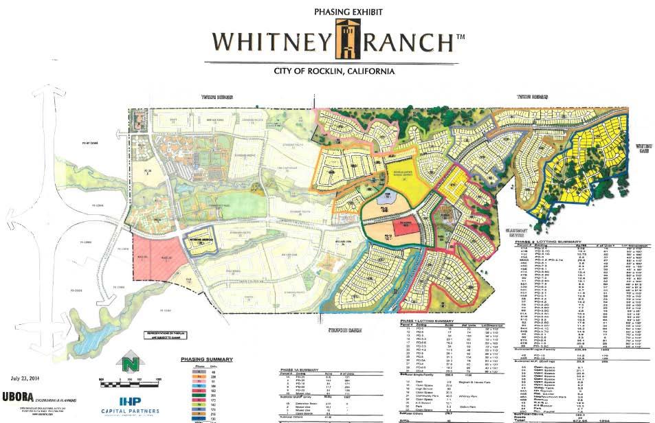
4
5
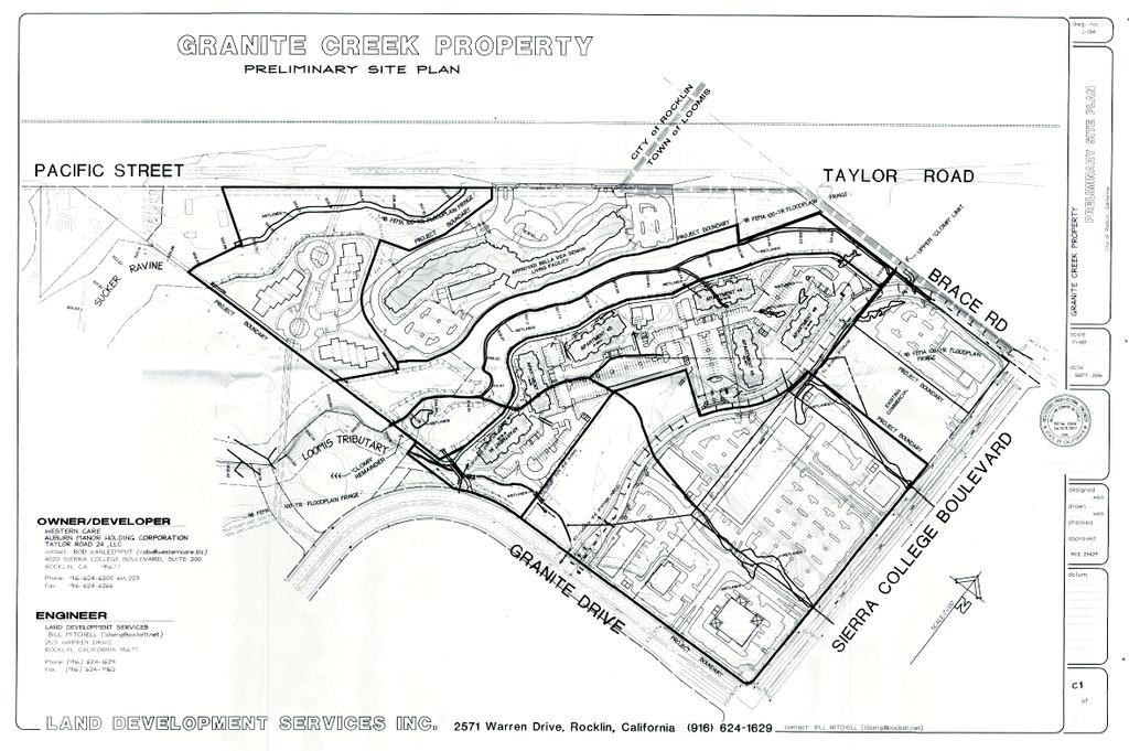
6

7 l SF
8
9
10
11
12
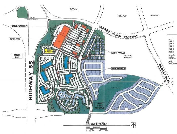
13 Pacific Street Corridor
14 Why the recent interest? This corridor has remained dormant for decades but is currently experiencing increased investment in staff opinion for the following reasons: City Council policy direction and support of economic development City investments in Quarry Park Resurgence of regional economy Deficit of remaining undeveloped site opportunities Opportunity for reuse of existing underutilized properties

15 Existing Projects


16 Project 1 Pacific Point unit multi-family 44 unit single-family 2 commercial outparcels


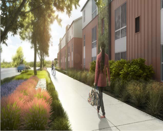
17 Project 2 Farron Street Retail 2 2,100 sq.ft. building 2.5 acre site Drive-thru and patio
 Pacific-Rocklin (1 acre) Oak-Pacific (2.")
18 Projects 3-5 City Properties 5 Big Gun (4.5 acres) Pacific-Rocklin (1 acre) Oak-Pacific (2.5 acres) 4 3

19 Projects 3-5 Rocklin Adventures At Quarry Park 2 Mixed-Use


20 Project 6 Rocklin-Pacific Roundabout 6 Improve traffic flow Support traffic calming Increase landscaping Improve aesthetics


21 Project 7 7 Rocklin Gateway 200 unit multi-family 7 acre site


22 Project 8 Quarry Row 64 unit single-family 7 acre site 8
23 New opportunities and goals? Given the resurgence of activity there may be additional opportunities the City can explore to leverage private investment the goals of which include: Attract visitors and consumer spending Increased job creation Increased beautification and landscaping Increased revenue to the City Opportunity for reuse of existing underutilized properties


24 Project 9 Pacific Mainstreet 9 Possible lane reduction on Pacific Possible diversion to Rail Road Avenue Increased parking Increased landscaping Outdoor seating Bicycle lanes


25 Pacific Mainstreet 9 Improved pedestrian environment Encourage new uses Attract visitors


26 Project 10 Railroad Corridor Development 9 Yankee Hill Road to Loomis border Limited options for use of UP property Auto sales Auto repair Greenbelt
27 The Road to Fiscal Sustainability Perhaps one of the greatest challenges of the elected official is to ensure the fiscal sustainability and qualify of life in their community.
28 An Old Adage If you always do what you ve always done, you ll always get what you always got. NOT ANYMORE

29 Reliance on Sales and Property Tax Federal and State Aid has diminished over the past decade Unlikely to change significantly in the near future and is more likely to continue to decrease Federal and State Aid is being distributed to a few targeted programs; many of which the City of Rocklin does not qualify for. Unfunded Mandates
30 The Way You Shop Will Change Forever Online Shopping has now reached a decade of maturity and brick and mortal stores are loosing the battle Macy s closed dozens of stores Sears closed more than 150 locations Kohl s fading away Target waves red flag JC Penny Closing 140 Stores
31 Re-Thinking How We Do Business Pre-2009/ FTE s FTE s We are not only doing more with less, we are doing it better Further the Use of Technology Capitalizing on the Shared Economy Where and How do we make the best use of our capital investments Privatization Destination Promotion
32 What is an intelligent transportation system? Technology that is leveraged to collect, convey, and share important information. ITS helps cities: Make informed decisions Improve transportation safety and mobility Enhance productivity
.")
33 Alternative Mitigations Mitigations and new technologies will be evaluated and implemented to the fullest extend possible (i.e., roundabouts synchronization of traffic signals, lengthened turn lanes, Trails development, etc).

34 Creating a network that talks
35 Now that you are Investing Smarter

36 Parks and Trails Master Plan Highlights Survey Results 96% satisfaction rate 73% engage in recreation activities at least 3x/month Johnson-Springview Park is most used park Trails for walking/running/biking most popular recreation activity Park types Community Parks Neighborhood Parks Recreation Area Natural Area/Greenbelt Linear Park Special Use Facilities

37 Parks and Trails Master Plan

38 The City of Rocklin will showcase the schedule of events, concerts, and community programs slated for Join us from 11 a.m. to 3 p.m. for fun with food trucks, activities, and live music! You'll also get to meet and greet city officials from each department to see how their teams help shape the community at this open house.
V. Vision and Guiding Principles
 V. Vision and Guiding Principles The Master Plan for the Powers Ferry Corridor seeks a foundation in the desires of the community. At times, various elements of the community offered opposing viewpoints,
Visioning Statement and Guiding Principles
 Visioning Statement and Guiding Principles Planning for the Future The General Plan The General Plan represents Woodland's shared vision of the future and defines a path to lead the community toward its
CHAPTER 7: Transportation, Mobility and Circulation
 AGLE AREA COMMUNITY Plan CHAPTER 7 CHAPTER 7: Transportation, Mobility and Circulation Transportation, Mobility and Circulation The purpose of the Transportation, Mobility and Circulation Chapter is to
Table L-1 Summary Action Strategy. Action Item Timing Status Responsible Agency
 CHAPTER 4: CIRCULATION ELEMENT ISSUE #1: MAJOR THOROUFARES AND TRANSPORTATION ROUTES A balanced transportation system for Fontana is provided that meets the mobility needs of current and future residents
Port Lavaca Future Land Use
 Port Lavaca Future Land Use Introduction The City of Port Lavaca is beginning to see sustained growth, after many years of relative stable population. New single family homes, apartments, and businesses
ITEM #8. Regional Smart Growth Program. Regional Smart Growth Program. Presentation Overview. Coast Highway Vision and Stategic Plan.
 Regional Smart Growth Program Economic Development Commission What is Smart Growth? Adopted as part of the Regional Comprehensive Plan (RCP) RCP provides vision for region based on Smart Growth and sustainability
Mississippi Drive Corridor Revitalization. A DestinationTransportation Project...
 Mississippi Drive Corridor Revitalization A DestinationTransportation Project... Mississippi Drive Corridor Revitalization Welcome! Tonight s Agenda: Further define the Scope of the Project Discuss the
Concord Community Reuse Project Goals and Guiding Principles. Overarching Goals (OG)
") Concord Community Reuse Project Goals and Guiding Principles Overarching Goals (OG) No priority is implied by the order of presentation of the goals and guiding principles. Overarching goals for the Concord
Concord Community Reuse Project Goals and Guiding Principles Overarching Goals (OG) No priority is implied by the order of presentation of the goals and guiding principles. Overarching goals for the Concord
TOWN COUNCIL / PLANNING COMMISSION
 Workshop #3 TOWN COUNCIL / PLANNING COMMISSION January 20, 2011 Consultant Team In Attendance Tonight BMS Design Group Nevada City and San Francisco Michael Smiley, AICP, ASLA Partner-in-Charge Nancy L.
BUILD Central Main Street Corridor Redevelopment Plan Public Meeting No. 3. September 14, 2017
 BUILD Central Main Street Corridor Redevelopment Plan Public Meeting No. 3 September 14, 2017 Follow Up Questions raised at the June meeting: Why are we doing this? Can t we just keep this area the same?
TRANSIT-ORIENTED DEVELOPMENT POLICY DRAFT. City Planning and Development Department Kansas City, Missouri
 TRANSIT-ORIENTED DEVELOPMENT POLICY DRAFT City Planning and Development Department Kansas City, Missouri What is Transit Oriented Development (TOD)? Development that focuses land uses around a transit
APN#: Lot Size: ±5,625 SF. Vacant corner lot. Current Height Limit: 70 FT. Current Zoning: CB - Central Business District
 900 MacDonald Avenue Richmond, CA 900 MacDonald Avenue Richmond Berkeley Features APN#: 538-260-001-2 Lot Size: ±5,625 SF Vacant corner lot Current Height Limit: 70 FT Current Zoning: CB - Central Business
Corridors. Re-vitalize our Corridors and Gateways
 Corridors Re-vitalize our Corridors and Gateways Artist s rendering from the 287 Strategic Plan, 2015 Corridors are the major throughways of Loveland but they also provide important commercial, community
The transportation system in a community is an
 7 TRANSPORTATION The transportation system in a community is an important factor contributing to the quality of life of the residents. Without a sound transportation system to bring both goods and patrons
Chapter 1: Introduction
 Chapter 1: Introduction The Penn Avenue Community Works Corridor Vision and Implementation Framework presents an integrated communitybased vision and a coordinated, long-term implementation framework for
Urban Planning and Land Use
 Urban Planning and Land Use 701 North 7 th Street, Room 423 Phone: (913) 573-5750 Kansas City, Kansas 66101 Fax: (913) 573-5796 Email: planninginfo@wycokck.org www.wycokck.org/planning To: From: City Planning
Comprehensive Plan ADOPTED APRIL 2014
 Comprehensive Plan ADOPTED APRIL 2014 8 8. Outstanding Recreational & Cultural Opportunities We are proud of our community s parks and recreation system. Our community will ensure that the legacy of our
Making Transit Oriented Development Work For Boonton, NJ
 Making Transit Oriented Development Work For Boonton, NJ Bloustein School of Planning and Public Policy Studio Dan Burton Loannie Dao Webster Slater Brandon Williams Ian Watson Maria Laham Nicola Mammes
Redevelopment of Downtown
 June 25, 2013 Redevelopment of Downtown Old US 41 Corridor Redevelopment Masterplan Downtown Color Palette Southern Shores and Beaches Sherwin Williams Downtown Vision Rendering Old Florida Design EcoDistricts
North Salt Lake General Plan Update 2013
 North Salt Lake General Plan Update 2013 Acknowledgements Updating the North Salt Lake General Plan was a process that would not have been possible without the support of elected officials and the general
Without leaps of imagination or dreaming, we lose the excitement of possibilities. Dreaming, after all, is a form of planning.
 City of Garden Grove A Publication for Garden Grove Residents and Businesses Fall 2014 Without leaps of imagination or dreaming, we lose the excitement of possibilities. Dreaming, after all, is a form
DRAFT PLAN PRESENTATION
 DRAFT PLAN PRESENTATION 1.23.2018 AGENDA Process Project Schedule Results from Visioning Workshop Draft Plan Highlights Concept Plans Feedback Next Steps PROJECT SCHEDULE KICK-OFF WORKSHOP August 29 th
Atlanta BeltLine Corridor Environmental Study. Scoping Meeting August 2008
 Atlanta BeltLine Corridor Environmental Study Scoping Meeting August 2008 What Will We Be Discussing Today? Study Overview - How Did We Get Here? - What Is the Study About? - Who Is Involved? - Where Is
Dyersville Downtown Plan. Open House October 24, 2017
 Dyersville Downtown Plan Open House October 24, 2017 What is a Comprehensive Plan? - Vision - Guidance for decisions - Basis for regulations What is a Downtown Plan? - Understand priorities - Identify
Gold Line Bus Rapid Transit Transit Oriented Development (BRTOD) Helmo Station Area Plan
 Helmo Station Area Plan") Appendix F Gold Line Bus Rapid Transit Transit Oriented Development (BRTOD) Helmo Station Area Plan Introduction and Purpose of the Plan The Gold Line Bus Rapid Transit facility is an eleven-mile dedicated
Appendix F Gold Line Bus Rapid Transit Transit Oriented Development (BRTOD) Helmo Station Area Plan Introduction and Purpose of the Plan The Gold Line Bus Rapid Transit facility is an eleven-mile dedicated
RE-Imagining the Downtown Colorado Springs Master Plan
 RE-Imagining the Downtown Colorado Springs Master Plan 2016 APA Colorado State Conference October 25, 2016 Overview 8:00 Welcome, Introductions, and Overview 8:15 Downtown s Planning History 8:30 A Market
EXECUTIVE SUMMARY. Introduction
 EXECUTIVE SUMMARY Introduction State Route 68 is a designated scenic route that connects the world-renowned Monterey Peninsula to US Highway 101 and the Salinas Valley. SR 68 is a key route for bicycle,
The Auburn Plan Designing the Future of Auburn February 28, 2005
 The Auburn Plan Designing the Future of Auburn February 28, 2005 Block-by-Block Bicycle Tour Aerial survey Focus Group Meetings September 7 and 8 Design Workshops October 11, 14, and 21 Revitalization
CENTRAL ESTUARY PLAN AVISION FOR OAKLAND S WATERFRONT
 Central Estuary Plan A VISION FOR OAKLAND S WATERFRONT Specific Plan and Environmental Assessment Presentation to the Parks and Recreation Advisory Commission December 9, 2009 This Afternoon s Presentation
Plano Tomorrow Vision and Policies
 Plano Tomorrow Vision and Policies PLANO TOMORROW PILLARS The Built Environment The Social Environment The Natural Environment The Economic Environment Land Use and Urban Design Transportation Housing
DRAFT FOR PUBLIC REVIEW. Game Plan for a Healthy City
 DRAFT FOR PUBLIC REVIEW 2018 Game Plan for a Healthy City 2 Denveright. Parks & Recreation Game Plan Draft for Public Review Draft for Public Review Executive Summary Game Plan Overview Executive Summary
C1TY AVENUE / REDEFINING THE WORKPLACE ONEC1TY NASHVILLE C1TY AVENUE VIEW FROM CHARLOTTE AVENUE
 C1TY AVENUE / REDEFINING THE WORKPLACE ENVIRONMENT @ ONEC1TY NASHVILLE C1TY AVENUE VIEW FROM CHARLOTTE AVENUE C1TY AVENUE / T H E C O M M U N I T Y A PLACE TO INNOVATE Welcome to active street corners,
Design Fort Ord. welcome why we are here what happened this week design guidelines: ideas so far 2/12/2015. Regional Urban Design Guidelines (RUDG)
") Design Fort Ord Regional Urban Design Guidelines (RUDG) Welcome Back! Strategic Economics Alta Planning + Design National Charrette Institute Helix Environmental Planning Jeff Speck & Peter Katz Civitas
Design Fort Ord Regional Urban Design Guidelines (RUDG) Welcome Back! Strategic Economics Alta Planning + Design National Charrette Institute Helix Environmental Planning Jeff Speck & Peter Katz Civitas
REGIONAL ACTIVITY CENTER
 DRAFT REGIONAL ACTIVITY CENTER 70 EAST BENCH MASTER PLAN DRAFT 06 Introduction The East Bench Regional Activity center is comprised of large educational, research, medical, and employment centers. These
WELCOME and introduction
 1 WELCOME and introduction Mobility Hub Locations within Burlington STUDY OVERVIEW STUDY OBJECTIVES The City of Burlington is developing four Area Specific Plans, one for each of Burlington s Mobility
Corridor Vision. 1Pursue Minnehaha-Hiawatha Community Works Project. Mission of Hennepin County Community Works Program
 1Pursue Minnehaha-Hiawatha Community Works Project Minnehaha-Hiawatha Community Works is a project within the Hennepin Community Works (HCW) program. The mission of the HCW program is to enhance how the
Wasatch CHOICE for 2040
 Wasatch CHOICE for 2040 Economic Opportunities We Can Choose a Better Future We enjoy an unparalleled quality of life along the Wasatch Front. People from all over the world are drawn to our stunning scenery,
The Lower SaLuda Greenway
 The Lower SaLuda Greenway InITIaTIve a FLourIShInG Greenway. a hub For economic GrowTh. a ConneCTIon BeTween CoMMunITIeS. In April 2017 the Michael J. Mungo Foundation and Lexington County commissioned
We are a determined group residents, industry, and government and by working together an incredible future lies ahead for Troy.
 PROPOSED EDITS TO COMPREHENSIVE PLAN April 5, 2018 Page Par Change Iv TOC Principle 2, page number is 3 should be 33 I Forward Par 3, delete Strike through: Troy is today experiencing 3 1.1 Par 3 change
City of Nogales General Plan
 Open Space, Parks, Recreation and Trails City of Nogales General Plan Residents of Nogales place a high priority in the development of a comprehensive system of open space, parks, recreation and trails
South Norfolk Municipal Facilities Study
 South Norfolk Municipal Facilities Study City of Chesapeake, VA P r e s e n t e d b y H B A A r c h i t e c t u r e & I n t e r i o r D e s i g n, I n c. 1 Purpose of the Study (Phase I) Identify potential
Sustainable Development Call for Projects Western Infrastructure Project Submissions
 2009-2010 Sustainable Development Call for Projects Western Infrastructure Project Submissions January 20, 2010 2009-2010 SDCFP Summary of Infrastructure Funding Infrastructure Projects Number of Projects
Secrest Short Cut and Monroe Expressway Small Area Plan AUGUST 29, 2018
 Secrest Short Cut and Monroe Expressway Small Area Plan AUGUST 29, 2018 Background and Process Monroe Expressway will be open by the end of 2018 Union County and Indian Trail identified a need to revisit
Grand Rounds History
 Grand Rounds History 1883 Plan for Minneapolis Park System prepared by Landscape Architect Horace W. S. Cleveland. The system of connecting parks and parkways was first called the Grand Rounds by William
Good education Good living Green future
 D66 Groningen - english summary of the election programme - 2018-2022 Good education Good living Green future Together we make Groningen Highlights 2 Groningen has many things to offer: a vibrant cultural
KEY FINDINGS. Community Engagement + Research
 PROJECT OVERVIEW PROJECT OVERVIEW PROJECT OVERVIEW KEY FINDINGS Community Engagement + Research Community Engagement Community Issues Workshop Steering Committee Workshop City Council/Planning Workshop
CHAPTER 7: VISION AND ACTION STATEMENTS. Noble 2025 Vision Statement
 CHAPTER 7: VISION AND ACTION STATEMENTS This chapter presents the vision, policy and action statements that transform the comprehensive planning study, an analysis of Noble s past, future trends and community
1.0 INTRODUCTION 1.1 TH 14 WEST STUDY AREA Project Description Functional Classification Purpose of the Project
 1.0 INTRODUCTION 1.1 TH 14 WEST STUDY AREA 1.1.1 Project Description The Trunk Highway (TH) 14 West Corridor is a two-lane roadway approximately 22 miles in length. Located in Nicollet County, the corridor
MEMORANDUM. I2 District Downtown Parking Overlay District 24,000 square feet /.55 acres. Industrial Employment District North Loop Small Area Plan
 Department of Community Planning & Economic Development 50 South 4th Street, Room 300 Minneapolis, MN 5545-385 MEMORANDUM To: City Planning Commission, Committee of the Whole Prepared By: Peter Crandall,
Urban Design 9Identity
 Urban Design 9Identity URBAN DESIGN IDENTITY Urban design is about connecting people to their places through the built environment, nature, and overall urban form. Done well, it creates a memorable space
Albert Lea. Redevelopment Plan. 701 Xenia Avenue South, Suite 300 Minneapolis, MN Tel: (763) Fax: (763) wsbeng.
 Fax: (763) wsbeng.") Albert Lea Redevelopment Plan 701 Xenia Avenue South, Suite 300 Minneapolis, MN 55416 Tel: (763) 541-4800 Fax: (763) 541-1700 wsbeng.com Albert Lea Redevelopment Plan Table of Contents Composite Districts...
Albert Lea Redevelopment Plan 701 Xenia Avenue South, Suite 300 Minneapolis, MN 55416 Tel: (763) 541-4800 Fax: (763) 541-1700 wsbeng.com Albert Lea Redevelopment Plan Table of Contents Composite Districts...
Midtown Greenway PROJECT REPORT CARD
 Midtown Greenway PROJECT REPORT CARD Project Overview and History The Midtown Greenway is a 5.5-mile multi-use trail that connects the Mississippi River to the Minneapolis Chain of Lakes. The corridor,
About Momentum Midland
 About Momentum Midland Achieving a community s full potential in terms of economic development and quality of life is critically important to its long term sustainability. Core to achieving this is a vibrant
Mendota Heights 2040 Comprehensive Plan Draft Vers
 4 Parks and Trails The City of Mendota Heights boasts a variety of recreational and open space opportunities. Few cities can claim access to regional trails, riverside and lakeside parks, scenic bluffs
SAN RAFAEL GENERAL PLAN 2040 INTRODUCTION AND OVERVIEW
 SAN RAFAEL GENERAL PLAN 2040 INTRODUCTION AND OVERVIEW Steering Committee Presentation February 14, 2018 Purpose of General Plan Guide land use and development decisions Coordinate transportation, infrastructure,
City of Hermosa Beach Administrative Policy #
 City of Hermosa Beach Administrative Policy # SUBJECT: Living Streets Policy Date: Approved by: City Council Authority: Public Works Department & Community Development Department Mayor, PURPOSE The City
Elm Fork Land Use. Trinity River Corridor Project Committee May 13, 2013
 Elm Fork Land Use Trinity River Corridor Project Committee May 13, 2013 Purpose Discuss Trinity River planned Land Use and Appropriate Compatible Uses, particularly with respect to the Elm Fork Area 2
9 th Street Sub Area Plan
 9 th Street Sub Area Plan In the 1990 s, when the Township prepared the last Master Plan, the 9 th Street corridor was studied as part of a larger 9 th Street Focus Area that included the West Main Street
THEMES, VISION, + PRINCIPLES
 CHAPTER 2: THEMES, VISION, + PRINCIPLES This page intentionally left blank. 20 VISION DRAFT AUGUST 2018 2 2 THEMES, VISION, + GUIDING PRINCIPLES The Key Themes, Vision, and Guiding Principles presented
A BLUEPRINT FOR BROCKTON A CITY-WIDE COMPREHENSIVE PLAN
 A BLUEPRINT FOR BROCKTON A CITY-WIDE COMPREHENSIVE PLAN Public Meeting October 2016 1 Plan Summary and Discussion Public Meeting May 4 2017 City of Brockton Bill Carpenter, Mayor Department of Planning
1 Introduction. Chapter. In this chapter:
 Chapter 1 Introduction In this chapter: 1.1 A Snapshot of the Region 1.2 Towards a Sustainable Region 1.3 The Provincial Context 1.4 Purpose and Organization The Regional Municipality of York Official
CITY OF UNION CITY MINUTES GENERAL PLAN ADVISORY COMMITTEE
 CITY OF UNION CITY MINUTES GENERAL PLAN ADVISORY COMMITTEE WEDNESDAY, MARCH 4, 2015, 6:30 P.M. IN THE CITY COUNCIL CONFERENCE ROOM OF CITY HALL 34009 ALVARADO-NILES BLVD., UNION CITY, CALIFORNIA Attachment
Green Infrastructure The Indianapolis Greenways Connection
 Green Infrastructure The Indianapolis Greenways Connection Fewer things in the transportation industry today make better since than combining the needs for pedestrian and bike trails with the need to locate,
4 C OMMUNITY D ISTRICTS
 4 C OMMUNITY D ISTRICTS N ew development in the Area will include many different types of land uses, including a destination retail area that attracts people from all over the region; recreation opportunities
Envision Concord Public Event Part 3. October 21, :30 AM 12:00 PM Concord-Carlisle High School Cafeteria
 Envision Concord Public Event October 21, 2017 9:30 AM 12:00 PM Concord-Carlisle High School Cafeteria Survey Responses + Emerging Priority Areas Summary from Spring Kick-Off Event Envision Concord Survey
City of Ennis. Downtown Master Plan Catalyst Projects
 City of Ennis Downtown Master Plan Catalyst Projects Revised Framework Plan REVISED Project Types and Descriptions Project Types A. Visitor Attracting Projects: Projects in this category are intended to
FONTANA URBAN GREENING
 FONTANA URBAN GREENING MASTER PLAN COMMUNITY WORKSHOP #1 DECEMBER 17th, 2018 GOALS Fontana Forward Comprehensive Plan Urban Greening Master Plan State/Local Landscape Regulations Fontana Active Transportation
City of Le Sueur DOWNTOWN MASTER PLAN
 City of Le Sueur DOWNTOWN MASTER PLAN City Council Update 9/11/2017 Hoisington Koegler Group Inc. Presentation Agenda 01 Schedule Update / Tonight s Objectives 02 What We ve Heard - Engagement Comments
Sahuarita District & Phase 1 Master Plan. Town Council December 11, 2017
 Sahuarita District & Phase 1 Master Plan Town Council December 11, 2017 Visioning Study Visioning Process Advisory Group Meetings Community Questionnaire Town Center Case Studies Community Analysis The
Ashland BRT Environmental Assessment: logos of CTA, CDOT, Chicago Department of Housing and Economic Development
 Ashland BRT Environmental Assessment: logos of CTA, CDOT, Chicago Department of Housing and Economic Development Overview The Chicago Transit Authority (CTA), in partnership with the Chicago Department
LPC Goals and Strategies. Transportation and Connectivity Employment Opportunities Food Access Waterfront Access Livable Communities
 LPC Goals and Transportation and Connectivity Employment Opportunities Food Access Waterfront Access Livable Communities Transportation and Connectivity Goal: Safe and ready access of all types allowing
Walnut Creek BART Station
 Walnut Creek BART Station Mixed Use Transit Oriented Project Design Review Commission Study Session May 17, 2006 Applicant: Walnut Creek Transit Lifestyles Associates Joint Venture: Transit Village Associates
2011 ASLA Design Awards. Centennial Park Merit Award Design Concepts CLA, Inc. Design over $500,000 Construction Budget
 2011 ASLA Design Awards Centennial Park Merit Award Design Concepts CLA, Inc. Design over $500,000 Construction Budget 2011 ASLA Colorado Professional Design Awards Project Name: Category: Location: Const.
ELK GROVE GENERAL PLAN VISION
 2-1 CHAPTER 2: 2-2 CREATING OUR The Community Vision for Elk Grove, expressed through a Vision Statement and a series of Supporting Principles, is a declaration of the kind of community that Elk Grove
Welcome. Comprehensive Plan & Transportation Plan Open House November 7, 2012
 Welcome Comprehensive Plan & Transportation Plan Open House November 7, 2012 Agenda Proposed future land use plan Comprehensive Plan strategies Traffic forecasts Future traffic operations Possible future
Yadkin River Greenway Feasibility Study Fact Sheet Village of Clemmons, Town of Lewisville, Town of Bermuda Run
 Fact Sheet Village of Clemmons, Town of Lewisville, Town of Bermuda Run Project Background The Yadkin River Greenway Feasibility Study is a joint project with the Village of Clemmons, the Town of Bermuda
Implementation Guide Comprehensive Plan City of Allen
 Implementation Guide 2030 Comprehensive Plan City of Allen DRAFT 2015 Implementation Guide Allen 2030 Comprehensive Plan INTRODUCTION The Comprehensive Plan serves as a guide for the growth and development
Tyvola & Archdale Transit Station Area Plan. June 5, 2008
 Tyvola & Archdale Transit Station Area Plan Second Public Meeting June 5, 2008 Presentation Outline 1. Purpose and Process 2. Station Area Overview 3. Plan Recommendations 4. Comments Received and Proposed
PLAN ELEMENTS WORKSHOP. April 5, 2016
 PLAN ELEMENTS WORKSHOP April 5, 2016 needs more housing. But there is no one-size fits-all solution. Every neighborhood has its own character. In some places, density is not only appropriate it is badly
City of Long Beach. creating vibrant and exciting places
 City of Long Beach creating vibrant and exciting places Land Use Element Urban Design Element Overview of the two draft General Plan elements Discuss areas of change Economic goals of the plans Case study
Bethesda Downtown Plan
 Bethesda Downtown Plan Planning Board Update Connecticut Avenue Location Economic Sustainability Social Environmental Scope Coming Soon! Team Listening, Twitter Outreach We Are Here Engagement Challenge
Pedestrian and Bike Bridge LOGO
 6.2.2 Pedestrian and Bike Bridge The proposed pedestrian and bike crossing re-envisions the existing bridge at Pismo Creek on Cypress Street. The bridge is currently underutilized by vehicular through
Strategic plan framework Steering Committee Meeting
 Strategic plan framework Steering Committee Meeting September 26, 2018 1 agenda 1 Welcome and Strategic Planning introductions Process Strategic Analyses Plan Framework 2 3 Brand Brand Development Naming
Waterfront Development Master Plan
 PORT of VANCOUVER USA Vancouver, WA Waterfront Development Master Plan DRAFT - FINAL CONCEPTUAL MASTER PLAN PROJECT TEAM NBBJ Heritage Research Associates JLA Kittelson Associates Leland Consulting Group
Planning Districts INTRODUCTION
 INTRODUCTION To facilitate detailed examination of development prospects for all areas of the community, Delano has been divided into 14 planning districts. The location of these planning districts is
What We Heard. Downtown Georgetown Planning Study. April 4, 2018
 What We Heard Downtown Georgetown Planning Study April 4, 2018 Workshop 2 - July 5, 2017 01 DESIGN SUMMIT The Downtown Georgetown Planning Study will guide growth and development in the downtown over the
TECHNICAL ASSISTANCE PANEL. Graniteville TAP: Developing a Community Vision
 TECHNICAL ASSISTANCE PANEL SPONSORED BY: Graniteville TAP: Developing a Community Vision Graniteville Community Development Improvement Corporation Mission To provide leadership in the responsible use
Outer Congress Street Land Use
 Outer Congress Street Land Use Outer Congress Street, with its historic residential district, natural resource and open space amenities, trail network, and proximity to major transportation infrastructure
Public Forum. Kelley s Corner: The Corner that Connects Us. The Cecil Group. March 7, Acton 2020 Town of Acton.
 Public Forum Acton 2020 Town of Acton March 7, 2013 AGENDA Purpose of Forum Kelley s Corner Project Examples of the Planning Processes Next Steps Dialogue: Questions and Answers PURPOSE Acton 2020 April
Current City Warehouse Facility. City Market Re-Use Concept. Indoor Market/ Maker s Incubator 1.06 acres +/- Open Air Market 1.
 Current City Warehouse Facility City Market Re-Use Concept Indoor Market/ Maker s Incubator 1.06 acres +/- Open Air Market Open 1.63 acres Air Market +/- 1.63 acres +/- 4.59 acres +/- Artists Workshops/
COMMUNITY INPUT SUMMARY FOR LAND USE TOPICS
 Planning and Development Department 14 North Street Claremont, New Hampshire 03743 Ph: (603) 542-7008 Fax: (603) 542-7033 Email: cityplanner@claremontnh.com www.claremontnh.com COMMUNITY INPUT SUMMARY
LUNDY S LANE COMMUNITY IMPROVEMENT PLAN STUDY
 PUBLIC INFORMATION MEETING #2 October 12, 2016 LUNDY S LANE COMMUNITY IMPROVEMENT PLAN STUDY AGENDA 5:00 to 5:30pm: Open House 5:30 to 6:15pm: Presentation 6:15 to 7:00pm: Individual paced workshop with
Errol Heights Park and Community Garden Frequently Asked Questions March 22, 2018
 Errol Heights Park and Community Garden Frequently Asked Questions March 22, 2018 Question 1: What improvements are planned for Errol Heights Park? How will the community be engaged in the process to shape
Downtown Elkton Station Area Plan, Elkton, MD. Difficult enough to get support for new starts challenge to fund Houston transit
 Difficult enough to get support for new starts challenge to fund Houston transit More difficult to build Community Support for dense development at station areas Major Concerns: Traffic, Property values,
Committee Meeting: Downtown Today & Concept Refinement September 11, 2017
 Committee Meeting: Downtown Today & Concept Refinement September 11, 2017 AGENDA 1. Brief Input Update 2. Comprehensive Plan Principles 3. Downtown Today 4. Concept Updates 5. Future Schedule What is a
Bourne Downtown Site Planning
 Prepared for: The Town of Bourne, MA In Cooperation with: Bourne Financial Development Corporation Prepared by:, Inc. June 24, 2009 Table of Contents Introduction and Summary... 1 Site Existing Conditions...
Equitable Growth Through TOD Planning
 Equitable Growth Through TOD Planning Community Meeting # 2 November 2017 Goals Objectives Extend investment from downtown Connect neighborhoods physically and economically Enhance places based on local
Chapter 3 Community Vision, Values, and Guiding Principles
 Chapter 3 Community Vision, Values, and Guiding Principles This Chapter presents the vision for Grand Rapids in 2030, supporting community values, and principles to guide implementation of the Comprehensive
Overview of the Plan. The Building Blocks of Centers, Neighborhoods and Network INTERNAL DRAFT
 Overview of the Plan 4 East Davidson Ramah Church Rd June Washam Rd Bradford District Park Bradford Shearer Rd Campus District NC 73 Davidson-Concord North Rocky River This Master Plan projects an approximate
a river of opportunity
 Kankakee Riverfront a river of opportunity Public Open House November 7, 2017 Can Kankakee use the river to connect its citizens? to support its economy? to attract more visitors? to reposition its brand?