University Hill Farms Neighborhood Planning Study
|
|
|
- Lindsay Adams
- 6 years ago
- Views:
Transcription


 MR")
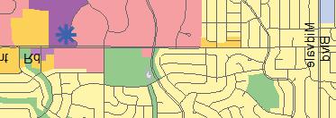

1 Vision Heading Statement Text The University vision for the next ten to fifteen years is to create a safe, strong community, rooted in the neighborhood s unique historic and cultural context that will benefit from sustainable improvement and maintenance of the neighborhood s family-friendly housing, expansive parks and open spaces, multimodal transportation infrastructure, growing commercial centers, and emerging development. The neighborhood vision will be achieved through public and private investments, developing practical amenities, creating places that serve all neighborhood residents, quality social services, and crafting a broader neighborhood identity that will establish it as not only a historic neighborhood, but also as an intergenerational, Generalized Future Land Use Plan ity of Madison March 2012 RESIENTIL ISTRITS LR Low ensity (0-15 units/acre) MR Medium ensity (16-40 units/acre) HR High ensity (41-60 units/acre) Lake Mendota UW campus Regional ontext: University Lake Monona (33) (34) Madison omprehensive Plan: Future Land Use k Not Shown (0) MIXE USE ISTRITS NMU Mixed-Use MU ommunity Mixed-Use RMU Regional Mixed-Use OMMERIL/EMPLOYMENT ISTRITS G General ommercial R Regional ommercial E Employment I Industrial OPEN SPE - GRIULTURE ISTRITS P Park and Open Space griculture/rural Uses SPEIL ISTRITS SI Special Institutional P irport ampus owntown istricts (See Volume II Map 2-3) NP Planning rea (TN Encouraged) SPEIL OVERLY ESIGNTIONS TO Transit-Oriented evelopment (onceptual Locations) TN Traditional evelopmen (May be applied to NP and residential districts as specified in neighborhood and special area plans.) Land Use Note Reference Number Other ities and Villages University Triangle Rennebohm Park Sawyer/Segoe Vernon/Price Karen rms Van Hise/ Hamilton School Focus reas within University


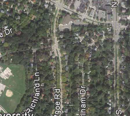
2 University Overall The northern portion of the neighborhood will continue to experience significant changes as demand for in-town housing and shopping increases. New investments in parks, transit, trails, and other public amenities will ensure the new development contributes positively to the overall community. University rossing Oak Park Place Living The Lodge at Walnut Grove WisOT (not in study area, RFP to be issued in Spring) Rennebohm Park N Se E goe R d Univ ersit y v e Hilldale Mall Kel a b r on rn Ve vd l nt St Rege N M vd l e al v id onceptual uild out of all Focus reas. University Triangle. Sawyer Segoe. Vernon / Price WisOT. Rennebohm Park (not in study area, E. Karen rms E N Midvale lvd Spring) N Segoe Rd RFP to be issued in


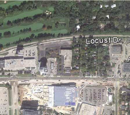
3 University Triangle With new transit investments and job growth in the area, the underutilized properties around Old Middleton Road and Whitney Way will be redeveloped into higher density housing and neighborhood mixed use. University ve N Whitney Way Way Expansion Red ross RT Illustrative Plan: University rossing and surrounding properties Units Height # sq. ft. # units spaces stories North of Old Middleton 60, South of Old Middleton Red ross Site 10, University ve Flatiron uildings The building on the east edge of the University triangle site can become a gateway and iconic building with spectacular views of the ity and the Lake. Whitney Way Sheboygan ve Perspective: University Triangle and surrounding properties


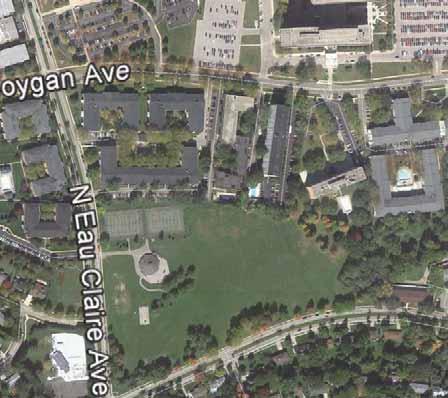
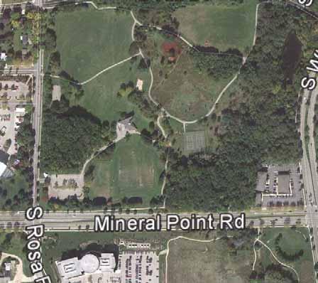
4 Rennebohm Park & Karen rms With an increased in population Rennebohm Park will become more active. Minor modifications to the park will help it serve a growing and changing population. OT Redevelopment Sheboygan ve ity easement us shelter Improved pavilion with restaurant and restrooms Walking paths & benches Existing paths Future park (gardens added to park) Segoe Rd Rd Ice rink New paths Karen rms Redevelopment Existing Existing Improved entrances Key recommendations: New paths and benches ommunity gardens Space for food trucks, venders New entrances to the park onnection to Sheboygan Improved pavilion with cafe, etc. Improved parking Flexible gathering space Illustrative Plan: Rennebohm Park & Karen rms Perspective Sketch: Rennebohm Park & Karen rms Existing Karen rms Site New Park Expansion Park Improvements & Placemaking dditions, such as a small restaurant, space for food carts, paths, seating, and gathering spaces, will allow Rennebohm Park to adjust to a growing and changing population.


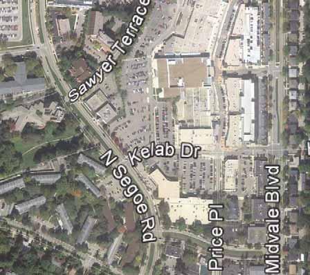
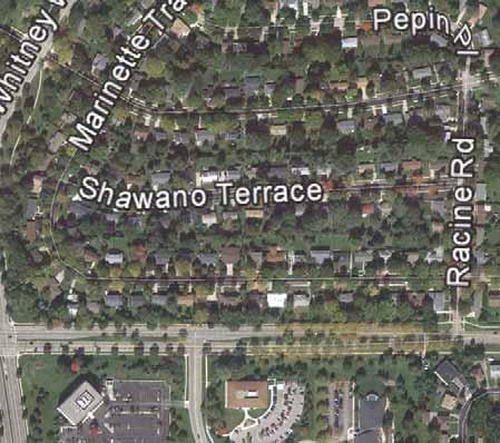
5 Sawyer / Segoe and Hilldale Redevelopment of this important corner could include a new Westside enter and a direct connection from Segoe to the west entrance of Hilldale and relate to expanded entrance at Rennebohm Park. Farmers market location Sawyer Terr Steps/ramp through site Hilldale Segoe Rd enter Medium ensity enter Height # units # sq. ft. stories enter 15,000 1 Illustrative Plan: Potential Redevelopment (8 stories) Medium ensity enter Sawyer Terr Terr onnection to Hilldale Farmers market location Steps as a place Well-designed stairways can create connections, establish a landmark, and be a special place to meet, sit, or walk. Perspective: Potential Redevelopment


 Midvale lvd Segoe St")


 Regent Regent St St")
6 Vernon / Price Redevelopment The 4 blocks south of Hilldale Mall can be redeveloped with senior housing, new offices, and retail that connects into Hilldale. The enter of the district can be created by converting Vernon oulevard into an attractive park. /Retail /Retail nchor ank (existing) Midvale lvd Segoe St Regent St Green space Vernon lvd Units Retail Height # sq. ft. # units # sq. ft. spaces stories lock 150, , lock 80,000-3, lock lock Illustrative Plan: Potential Redevelopment Hilldale Segoe St St Vernon lvd enter (alt) Regent Regent St St Perspective: Potential Redevelopment Perspective sketch looking west on Vernon lvd Vernon lvd - existing


7 Van Hise / Hamilton School The campus is large, but not as active as it can be. Minor improvements will help integrate the school into the community. irculation improvements will reduce existing safety concerns. Waukesha St Outdoor classroom Key Recommendations dd parent drop off from Segoe. Maintain and improve bus drop off. dd playing fields. reate mile loop run. dd outdoor education opportunities. dd tot lot and terraced gardens on Segoe. us line-up Parent drop-off Soccer Prairie Terraced garden Mile run path Tot lot Segoe Segoe St St Illustrative Plan: Potential Improvements to the School Grounds Outdoor classrooms Terraced gardens
U T D N o r t h C a m p u s T O D and D o w n t o w n D e n t o n T O D
 U n i v e r s i t y o f T e x a s a t D a l l a s C i t y o f R i c h a r d s o n U T D N o r t h C a m p u s T O D and D o w n t o w n D e n t o n T O D Rick Leisner, AICP Assistant Director of Development
U n i v e r s i t y o f S o u t h C a r o l i n a A i k e n. Land Plan Study
 U n i v e r s i t y o f S o u t h a r o l i n a A i k e n Land Plan Study 06.27.2008 Goals ampus Growth Develop a Land Plan that allows for the orderly expansion of the campus over the next ten years and
THE 355/270 CORRIDOR:
 THE 355/270 CORRIDOR: Strategic Ideas for Sustaining a Livable Work Place Project Summary ACCESS LIFE DESIGN HEALTH WORK Montgomery County Planning Department The Maryland-National Capital Park and Planning
EXISTING COMPREHENSIVE PLAN
 EXISTING COMPREHENSIVE PLAN Town Center Land Use Element: V. LAND USE POLICIES Town Center Mercer Island's business district vision as described in "Your Mercer Island Citizen-Designed Downtown" was an
4 C OMMUNITY D ISTRICTS
 4 C OMMUNITY D ISTRICTS N ew development in the Area will include many different types of land uses, including a destination retail area that attracts people from all over the region; recreation opportunities
5 Land Use Element49
 5 Land Use Element 49 City of Forney - Comprehensive Plan Land Use Introduction Forney s Comprehensive Plan is a guide for physical and economic development in the City of Forney over the next 20-years.
2.0 THE PLATINUM TRIANGLE VISION
 2.0 THE PLATINUM TRIANGLE VISION The envisions an exciting future for the area surrounding Angel Stadium of Anaheim, the Honda Center and The Grove of Anaheim. 2.1 Planning Principles In order to further
Making Transit Oriented Development Work For Boonton, NJ
 Making Transit Oriented Development Work For Boonton, NJ Bloustein School of Planning and Public Policy Studio Dan Burton Loannie Dao Webster Slater Brandon Williams Ian Watson Maria Laham Nicola Mammes
RE-Imagining the Downtown Colorado Springs Master Plan
 RE-Imagining the Downtown Colorado Springs Master Plan 2016 APA Colorado State Conference October 25, 2016 Overview 8:00 Welcome, Introductions, and Overview 8:15 Downtown s Planning History 8:30 A Market
TOWN COUNCIL / PLANNING COMMISSION
 Workshop #3 TOWN COUNCIL / PLANNING COMMISSION January 20, 2011 Consultant Team In Attendance Tonight BMS Design Group Nevada City and San Francisco Michael Smiley, AICP, ASLA Partner-in-Charge Nancy L.
NORTH LAKE SPECIFIC PLAN AREA
 NORTH LAKE SPECIFIC PLAN AREA June 21, 2018 WELCOME Workshop Agenda Introduction Provide information about the program and introduce the team Background Information Share information about the North Lake
Workshop #3 June 13, 2016
 Downtown Ocoee Master Plan Workshop #3 June 13, 2016 Our Team Our Team and Tonight s Goal Quick Recap: Why a Downtown Plan? How are we developing the plan? How can you still be involved? What s left to
The University District envisions, in its neighborhood
 Envisioning the University District Link Light Rail in Seattle s neighborhoods CIY OF SEALE CONCEP-LEVEL SAION AREA PLANNING RECOMMENDAION RESOLUION # 30165 EXHIBI L Vision 08.2000 he University District
MALL REVITALIZATION CASE STUDIES
 MALL REVITALIZATION CASE STUDIES DECEMBER 9, 2012 MALL REVITALIZATION OVERVIEW Introduction Sample Case Studies prepared for Lacey Woodland District Steering Committee as it considers strategies to revitalize
Commercial Node Plan Devine Street/Jackson Blvd. COLUMBIA, SC
 Commercial Node Plan Devine Street/Jackson Blvd. COLUMBIA, SC 9.17.13 AGENDA 1 Introductions 2 Project Update 3 Concepts 4 Recommendations 5 Next Steps Introductions Project Update Process 5-Phase Process
Mendota-Lebanon Hills Greenway Master Plan Executive Summary. August draft for more information visit
 Mendota-Lebanon Hills Greenway Master Plan Executive Summary August 2013 draft for more information visit www.hkgi.com/projects/dakota INTRODUCTION The Mendota-Lebanon Hills Greenway Master Plan portrays
K. SMART ASSOCIATES LIMITED
 Planning Justification Report Zoning By-Law Amendment 185 King Street North Waterloo, Ontario April 7th, 2017 Project Reference Number 16-245 K. SMART ASSOCIATES LIMITED CONSULTING ENGINEERS AND PLANNERS
Sahuarita District & Phase 1 Master Plan. Town Council December 11, 2017
 Sahuarita District & Phase 1 Master Plan Town Council December 11, 2017 Visioning Study Visioning Process Advisory Group Meetings Community Questionnaire Town Center Case Studies Community Analysis The
Blue Line LRT Extension
 v e Noble Pkwy Noble Pkwy Xerxes Ave N Shingle Creek Penn Ave N Penn Ave N Fremont Ave N Lyndale Ave N S Washington Ave University Ave NE Blue Line LRT Extension LIGHT RAIL PLATFORM AND STATION DESIGN
Description of Preferred Alternative
 Chapter 2 Description of Preferred Alternative 2.1 Introduction This chapter of the programmatic Sammamish Town Center Sub-area Plan Final EIS provides a more detailed description of the Preferred Alternative
Subarea 4 Indian Creek. Vision The combination of park networks and transportation amenities make Subarea 4 the greenest hub in the Corridor.
 indian creek 180 extends south from 101st Street to I-435. The I-435 and Metcalf intersection is one of the primary intersections in the Kansas City Metro Area. The area includes several residential neighborhoods
NORTH CLAYMONT AREA MASTER PLAN COMMUNITY WORKSHOP #1 FEBRUARY 3, 2016
 NORTH CLAYMONT AREA MASTER PLAN COMMUNITY WORKSHOP #1 FEBRUARY 3, 2016 1. Introduction To the team and to the Plan Planning Partners The Claymont Community WILMAPCO New Castle County Claymont Renaissance
Property Profile 2954 WEST FRANKLIN ROAD MERIDIAN, ID
 082614 FOR SALE > MIXED-USE LAND Franklin & Ten Mile Land 2954 WEST FRANKLIN ROAD MERIDIAN, ID Property Profile > ~38 acres for sale, located on the NE corner of Franklin and Ten Mile > Power and gas running
Courthouse Square Planning & Urban Design Study. Courthouse Square Working Group #13 October 15, 2014
 Courthouse Square Planning & Urban Design Study Courthouse Square Working Group #13 October 15, 2014 1 Courthouse Square Process Working Group Community Courthouse Square Advisory Groups & Civic Associations
THE CIVIC DISTRICT DEVELOPMENT OPPORTUNITIES
 1 THE CIVIC DISTRICT DEVELOPMENT OPPORTUNITIES The Civic District is the physical and emotional heart of the downtown. It is also a major gateway into the central core, establishing the image and identity
Status Report: MD 355 Project
 Status Report: MD 355 Project OCTOBER 2006 M-NCPPC MONTGOMERY COUNTY PLANNING DEPARTMENT Summary of Community Comments, and break to the Results of the MD 355 Participation Session Brookside Gardens -
ORDINANCE AN ORDINANCE TO ADD A NEW SECTION 4.N. IN THE ZONING CODE FOR THE TOWN OF MIDDLETOWN, RELATING TO MIXED-USE DEVELOPMENT
 Introduced: November 5, 2018 Approved: ORDINANCE 18-11-01 AN ORDINANCE TO ADD A NEW SECTION 4.N. IN THE ZONING CODE FOR THE TOWN OF MIDDLETOWN, RELATING TO MIXED-USE DEVELOPMENT BE IT ENACTED BY THE MAYOR
Lower Merion Commercial Districts Issues and Characteristics Handbook November 2013
 Lower Merion Commercial Districts Issues and Characteristics Handbook November 2013 DRAFT TOWNSHIP-WIDE VISION: To maintain and enhance commercial areas to complement the surrounding high-quality residential
WELCOME and introduction
 1 WELCOME and introduction Mobility Hub Locations within Burlington STUDY OVERVIEW STUDY OBJECTIVES The City of Burlington is developing four Area Specific Plans, one for each of Burlington s Mobility
Town Center (part of the Comprehensive Plan)
") Town Center (part of the Comprehensive Plan) Mercer Island Town Center Looking North (2014) In 1994, a year-long process culminated in a set of design guidelines and code requirements for the Town Center
Town Center (part of the Comprehensive Plan) Mercer Island Town Center Looking North (2014) In 1994, a year-long process culminated in a set of design guidelines and code requirements for the Town Center
Connecting Key Activity Centers with High Quality Bus Service
 Connecting Key Activity Centers with High Quality Bus Service Lessons Learned from the DC Circulator Transit Development Plan April 15, 2011 1 DC Circulator Transit Development Plan Ten-year plan for development
A P P E N D I X B - O P P O R T U N I T Y S I T E S
 A P P E N D I X B - O P P O R T U N I T Y S I T E S OPPORTUNITY SITES As listed in the Land Use Element, the City has identified 15 Opportunity Sites expected to be the focus of change and revitalization
Mix of Uses Guide for Transit-Oriented Development MIX OF USES
 MIX OF USES Creating a Destination Magnet A diversity of uses such as retail, housing, offices, civic and entertainment within the TOD creates a destination magnet for transit users and TOD neighbors.
FOR IMMEDIATE RELEASE Contact: Dyana Koelsch
 FOR IMMEDIATE RELEASE Contact: Dyana Koelsch 401.831.1200 dkoelsch@nharbor.com Revised Gateway Plan Decreases Retail, Adds 70% More Office Space and Improves Entrance to Quonset Business Park Incorporating
Creating Quality Places: Successful Communities by Design
 Creating Quality Places: Successful Communities by Design Communities across the metropolitan Kansas City area are growing. Our challenge is to shape future development in ways that will maintain and enhance
Gold Line Bus Rapid Transit Transit Oriented Development (BRTOD) Helmo Station Area Plan
 Helmo Station Area Plan") Appendix F Gold Line Bus Rapid Transit Transit Oriented Development (BRTOD) Helmo Station Area Plan Introduction and Purpose of the Plan The Gold Line Bus Rapid Transit facility is an eleven-mile dedicated
Appendix F Gold Line Bus Rapid Transit Transit Oriented Development (BRTOD) Helmo Station Area Plan Introduction and Purpose of the Plan The Gold Line Bus Rapid Transit facility is an eleven-mile dedicated
Review of Opportunity Area C Draft Comprehensive Plan and Draft BOS Follow-On Motions. Special Working Group Meeting March 4, 2015
 Review of Opportunity Area C Draft Comprehensive Plan and Draft BOS Follow-On Motions Special Working Group Meeting March 4, 2015 The slides that follow identify where the draft Comprehensive Plan has
SOUTHEAST SPORTS COMPLEX MASTER PLAN
 REPORT TO SOUTHGATE NEIGHBORHOOD COUNCIL APRIL 13, 2016 Visioning Process April 30: Stakeholder Meeting with Sports Groups May 5: Stakeholder Meeting with Southgate Land Use Committee May 13: SNC Meeting
THE NEIGHBORHOOD TODAY
 THE NEIGHBORHOOD TODAY CORE AREA VISION How are we Good Urbanism A Site s DNA thinking about Elements of great Unique elements urban communities embedded in a place the site and design? ELEMENTS LIKE:
Neighborhood Districts
 NEIGHBORHOOD DISTRICTS SEVEN MAIN DISTRICTS Neighborhood Districts While the Development Plan provides a broad-scale overview of the neighborhood, this section focuses on uses and relationships at the
Comprehensive Plan Advisory Panel Meeting #3
 Comprehensive Plan Advisory Panel Meeting #3 November 7, 2016 Agenda 1. September 19 th Meeting Notes 2. Summary of Focus Areas Charrette 3. Heart of the City Focus Area a. HOC2/Station Areas Concept &
Glenborough at Easton Land Use Master Plan
 Vision Statement Sunrise Blvd. Hazel Ave. Prairie City Rd. Gencorp Property Lincoln Regional Airport 1.0 VISION STATEMENT The identifies City of the principles, goals, policies, and standards Lincoln that
MONTGOMERY COUNTY METRO STATION AREA DESIGN CHARRETTE
 MONTGOMERY COUNTY METRO STATION AREA DESIGN CHARRETTE Shady Grove Metro Station Area Charrette Closing Presentation October 25-28, 2000 MONTGOMERY COUNTY, MD M-NCPPC Design Collective, Inc. Architects
City of Lake Mary, Florida. Evolution of a Historic Downtown with Transit Oriented Development Strategies
 City of Lake Mary, Florida Evolution of a Historic Downtown with Transit Oriented Development Strategies What is Transit Oriented Development? Walkable villages located at and around transit stations in
West Kendall Corridor June 11, 2014
 June 11, 2014 Miami-Dade County Department of Regulatory and Economic Resources Development Services Division ā 1 Presentation Outline Review Study Area Review of Citizens Plans and Presentations Planning
City of Tacoma Planning and Development Services
 Agenda Item E-1 City of Tacoma Planning and Development Services To: Planning Commission From: Elliott Barnett, Planning Services Division Subject: Tacoma Mall Regional Center Subarea Plan and EIS Meeting
This Review Is Divided Into Two Phases:
 Semiahmoo Town Centre Review The purpose of this review: To review the Semiahmoo Town Centre Concept Plan, originally approved in 1993, to ensure that this centre will continue to serve the needs of South
Transit-Oriented Development
 Transit-Oriented Development Path to Sustainability West Windsor February 22, 2007 George S. Hawkins Context for Presentation NJ Future is a non-partisan, 501(c)3 non-profit organization. Offer perspective,
Thousand Oaks Downtown Core Master Plan. Master Plan Open House April 26, 2018
 Thousand Oaks Downtown Core Master Plan Master Plan Open House April 26, 2018 The Site Community Outreach Events Online Community Survey (March 17 - April 22, 2018) 689 responses Pop-Up Workshops Oaks
ELK GROVE GENERAL PLAN VISION
 2-1 CHAPTER 2: 2-2 CREATING OUR The Community Vision for Elk Grove, expressed through a Vision Statement and a series of Supporting Principles, is a declaration of the kind of community that Elk Grove
Plano Tomorrow Vision and Policies
 Plano Tomorrow Vision and Policies PLANO TOMORROW PILLARS The Built Environment The Social Environment The Natural Environment The Economic Environment Land Use and Urban Design Transportation Housing
City Council March 27, Parks, Recreation, and Trails Master Plan
 City Council March 27, 2018 Parks, Recreation, and Trails Master Plan Planning Process Develop Goals and Objectives Inventory of Areas and Facilities Needs Assessment And Identification Public Participation
A New Vision For Highland
 A New Vision For Highland ULI Austin Breakfast Wednesday April 24, 2013 Dr. Richard Rhodes President/CEO Austin Community College Panelists: Chris Riley Councilmember Place 1 City of Austin Matt Whelan
Colorado Station 2.0
 Colorado Station 2.0 Spring 2016 MURP Workshop UC Denver Ellen Ittelson Gregory Meek Megan Yonke Katelyn Puga Nathan Silverstein Claire Dalby Matthias Helfen Mark Richardson Jake Schmitz Gaby Hart Lauren
Rio/29 Future Land Use Alternatives. Rio/29 Small Area Plan Phase 1 December 12, 2016
 Rio/29 Future Land Use Alternatives Rio/29 Small Area Plan Phase 1 December 12, 2016 PRESENTATION OVERVIEW 1 BACKGROUND 2 COMMUNITY INPUT 3 DESIGN PRINCIPLES 4 5 ALTERNATIVES OPEN HOUSE 2 1 PROJECT BACKGROUND
New Town Mixed Use District
 New Town Mixed Use District Montgomery County Planning Commission 2009 Annual Conference PA Chapter of the American Planning Association October 6, 2009 What is NTMU? More urban style of development Complementary
Reconnecting to a Forgotten River St. Cloud MN. Aaron Hanson Design Design Thesis LA 572, Thesis, Spring 2012
 Reconnecting to a Forgotten River St. Cloud MN Aaron Hanson Design Design Thesis LA 572, Thesis, Spring 2012 site context 2.5 Miles Sartell St. Cloud to Fargo 170 Miles (2 hrs 45 mins) Hwy 10 infrastructure
Table of Contents. Elm Avenue Improvement Plan City of Waco, Texas. Introduction 1. Existing Context 1 Figure 1 2.
 Table of Contents Introduction 1 Existing Context 1 Figure 1 2 Plan Guidelines 3 Future Urban Form 4 The West-End 4 Main Street 6 The East-End 7 Figure 2 9 Public Improvement Recommendations 7 General
REVIEW AND EVALUATION OF REGIONAL LAND USE
 REVIEW AND EVALUATION OF REGIONAL LAND USE AND TRANSPORTATION SCENARIOS #220831 Environmental Justice Task Force October 7, 2014 VISION 2050 Process Development of Guiding Vision for Land Use and Transportation
Refocus Kodak: Themes and Ideas to Date As of May
 Refocus Kodak: Themes and Ideas to Date As of May 21 2014 The Refocus Kodak Campaign has been hearing from the community since early 2014. Below are some of the themes that we have been hearing and some
1.0 VISION STATEMENT. December 6, PRINCIPLES
 Vision Statement Lincoln Regional Airport 1.0 VISION STATEMENT 1.1 City LOCATION of AND OVERVIEW The Easton Lincoln Place Land Use Master Plan identifies the principles, goals, policies, and standards
CHAPTER 7: Transportation, Mobility and Circulation
 AGLE AREA COMMUNITY Plan CHAPTER 7 CHAPTER 7: Transportation, Mobility and Circulation Transportation, Mobility and Circulation The purpose of the Transportation, Mobility and Circulation Chapter is to
Northwest commuter rail station US 36 BRT. Westminster Station
 Northwest commuter rail station Westminster Station US 36 BRT Westminster Center US 36 & Church Ranch Broomfield Flatiron/96 th St. US 36 & McCaslin Table Mesa Boulder Junction 13-month effort that will
Shady Grove Sector Plan
 Montgomery Planning Area 2 Division 11/15/2018 Shady Grove Sector Plan Minor Master Plan Amendment Scope of Work Edit presentation title MM/DD/YYYY 1 Purpose for the Plan Amendment 1. Reevaluate/status
COLISEUM VISION. OLISEUM AREA SPECIFIC PLAN Public Workshops April 2014
 OLIUM AA PIFI PLAN OLIUM VIION GOAL Goal 1 etain Oakland s sports teams, and maximize the economic benefit of the sports teams and their facilities for Oakland and Alameda ounty. OBJTIV efine a unique
South East Sports Complex Phase I
 South East Sports Complex Phase I City of Spokane Design Review Board August 29, 2018 (Revised) Objectives 1. Early discussion and collaboration. 2. Provide framework / catalyst for future improvements
City of Long Beach. creating vibrant and exciting places
 City of Long Beach creating vibrant and exciting places Land Use Element Urban Design Element Overview of the two draft General Plan elements Discuss areas of change Economic goals of the plans Case study
Principles of Community Placemaking & Making Places Special
 Principles of Community Placemaking & Making Places Special An Overview for Your Community By Steve Grabow Professor and Community Development Educator UW-Extension, Jefferson County Context for Principles
Establishment of Zoning Districts
 CHAPTER 6 Establishment of Zoning Districts 6. Section 601 Zoning by Districts: In accordance with the provisions of LUDMA that allows the Council to divide the area of the Town into Zoning Districts,
Tacoma Mall Neighborhood Subarea Plan & EIS. Planning Commission February15, 2017
 Tacoma Mall Neighborhood Subarea Plan & EIS Planning Commission February15, 2017 1 Meeting objectives Commission direction on: Medium and Long-term visions Residential, neighborhood and housing topics
GAMMAGE SQUARE - RECOMMENDATIONS
 GAMMAGE SQUARE - RECOMMENDATIONS We envision an expanded cultural district surrounding the historic ASU Gammage. Creating a cultural district will enhance the existing historic landmark by activating the
Westwind Developments Ltd. PIONEER LANDS AREA STRUCTURE PLAN - PROPOSED AMENDMENT
 FEBRUARY 2013 TABLE OF CONTENTS 1.0 BACKGROUND... 1 1.1 Amendment... 1 2.0 LOCATION & CONTEXT... 2 2.1 Land Ownership... 2 3.0 POLICY CONTEXT... 3 3.1 Municipal Development Plan... 3 3.2 Capital Region
Port Lavaca Future Land Use
 Port Lavaca Future Land Use Introduction The City of Port Lavaca is beginning to see sustained growth, after many years of relative stable population. New single family homes, apartments, and businesses
2.0 AREA PLANS. Lakeside Business District. Lakeside Business District Land Use Categories:
 Lakeside Business District Lakeside Business District Land Use Categories: Campus Commercial Campus Commercial means a mixture of uses which includes corporate offices, office parks, hotels, commercial,
Town Center. Block 5 Existing multifamily residential units are expected to remain.
 Area Guidelines Germantown s districts should be developed as distinct communities with unique features that are supported through the guidelines. The guidelines not only help distinguish these districts
Draft Memorandum #1: Goals and Vision for Revitalization
 Keizer Revitalization Plan Draft Memorandum #1: Goals and Vision for Revitalization Submitted to: City of Keizer April 12, 2018 (revised) Prepared By: Angelo Planning Group and Otak, Inc. Project No. 17482.A
CITY OF UNION CITY MINUTES GENERAL PLAN ADVISORY COMMITTEE
 CITY OF UNION CITY MINUTES GENERAL PLAN ADVISORY COMMITTEE WEDNESDAY, MARCH 4, 2015, 6:30 P.M. IN THE CITY COUNCIL CONFERENCE ROOM OF CITY HALL 34009 ALVARADO-NILES BLVD., UNION CITY, CALIFORNIA Attachment
3.1 community vision. 3.3 required plan elements
 Chapter 3 Community Form 3.1 community vision 3.2 Parks & landscaping concepts 3.3 required plan elements D R A F T 20 Community Form Chapter 3 3.0 Community form 3.1 community vision The Specific Plan
Sustainably Repositioning Greyfield Sites. Greyfield Sites Anywhere
 Sustainably Repositioning Greyfield Sites Jim Constantine Looney Ricks Kiss Architects Todd Poole 4ward Planning Greyfield Sites Anywhere Pennsylvania Chapter American Planning Association Conference 2009
The Lodge at Saint Edward State Park, One of Many Projects Transforming the City of Kenmore
 The Lodge at Saint Edward State Park, One of Many Projects Transforming the City of Kenmore July 11, 2018 By Jack Stubbs What I like about Kenmore is that it s an aspirational kind of community; people
TEN MILE & FRANKLIN LAND 39± ACRES 2954 WEST FRANKLIN ROAD MERIDIAN, ID
 PROPERTY INMATION HIGHLIGHTS Property Type: Land»» Access points: Three commercial access points on Ten Mile Land Size: 38.99 Acres Parcel: S1211336065 Zoning: RUT: Rural Urban Transition Future Zoning:
What Pioneer Grove Will Look Like?
 The City of Deerfield Beach has embarked on a journey to create a new town center within the old heart of Deerfield Beach. The new town center is known as Pioneer Grove. Pioneer Grove will be Everybody
Open and transparent Ground-breaking, national demonstration project Golden Run is committed to Erie Growth can be profitable to the Town of Erie
 Open and transparent Ground-breaking, national demonstration project Golden Run is committed to Erie Growth can be profitable to the Town of Erie Golden Run will deliver sustainable economic development
Urban Analysis. Downtown Zanesville like any city, has been physically modified through time as it
 Urban Analysis As a part of the consulting team s reconnaissance effort, an urban analysis was performed. Before the future of a place can be envisioned, one must understand the physical characteristics
THEMES, VISION, + PRINCIPLES
 CHAPTER 2: THEMES, VISION, + PRINCIPLES This page intentionally left blank. 20 VISION DRAFT AUGUST 2018 2 2 THEMES, VISION, + GUIDING PRINCIPLES The Key Themes, Vision, and Guiding Principles presented
Lynn Housing Authority and Neighborhood Development. Washington Street Gateway District Plan A p r i l
 Lynn Housing Authority and Neighborhood Development Washington Street Gateway District Plan A p r i l 2 0 0 8 rendering of sagamore hill from lynnway pedestrian overpass table of contents project area
Blueprint Denver A BLUEPRINT FOR AN INCLUSIVE CITY. Executive Summary
 Blueprint Denver A BLUEPRINT FOR AN INCLUSIVE CITY Executive Summary PUBLIC REVIEW DRAFT 2 1/7/2019 DENVERIGHT BLUEPRINTDENVER Blueprint Denver: A Blueprint for an Inclusive City An Equitable City Planning
WEST LOOP DESIGN GUIDELINES CHECKLIST
 WEST LOOP DESIGN GUIDELINES CHECKLIST Section 1.0 General Strategies 1.1 DESIGN EXCELLENCE: ENCOURAGE HIGH QUALITY AND INNOVATIVE DESIGN OF NEW BUILDINGS WITHIN THE WEST LOOP WITHOUT BEING PRESCRIPTIVE
SOUTH NATOMAS COMMUNITY PLAN
 SOUTH NATOMAS Community Plan Part Three : COMMUNITY PLAN AREAS AND SPECIAL STUDY AREAS SACRAMENTO 2030 GENERAL PLAN Contents Community Location... 3-SN-3 Community Vision... 3-SN-4 Community Profile...
D-O LRT Zoning Discussion. Chapel Hill Boards & Commissions October 16, 2017
 D-O LRT Zoning Discussion Chapel Hill Boards & Commissions October 16, 2017 Update on Overall D-O LRT Station Area Initiative Objectives Design and educate on principles of Good Transit-Oriented Development
2035 General Plan Update and Belmont Village Specific Plan. Joint Study Session with the City Council and Planning Commission April 12, 2016
 2035 General Plan Update and Belmont Village Specific Plan Joint Study with the City Council and Planning Commission April 12, 2016 Agenda 1. Welcome and Introductions 2. General Plan Update Status of
DOWNTOWN CHAPEL HILL SMALL AREA PLAN
 DOWNTOWN CHAPEL HILL SMALL AREA PLAN A Component of the Chapel Hill Comprehensive Plan With DOWNTOWN DESIGN GUIDELINES Adopted March 27, 2000 TABLE OF CONTENTS SECTION PAGE 1. Vision Statement.. 5 2. Goals
Dowdy Park. Concept Plans TOWN OF NAGS HEAD NORTH CAROLINA. Developed by: Albemarle & Associates, Ltd VHB/ Vanasse Hangen Brustlin, Inc.
 TOWN OF NAGS HEAD NORTH CAROLINA Concept Plans Developed by: Albemarle & Associates, Ltd VHB/ Vanasse Hangen Brustlin, Inc. Site Looking Southeast Dowdy Park Existing Conditions Nags Head Woods Sound Future
Cultivate Hopkins: Built Environment. Comprehensive Plan Advisory Committee September 13, 2017
 Cultivate Hopkins: Built Environment Comprehensive Plan Advisory Committee September 13, 2017 Four Dimensions of a Sustainable Plan Land Use Urban Design Housing Transportation Resilience Water Resources
Packet Contents. Joint Planning Work Session Timeline.. Introduction.. Work Session Directions... 5
 City Council and Planning & Zoning Commission Joint Planning Work Session Packet June 30, 2014 1 2 Packet Contents Joint Planning Work Session Timeline.. Introduction.. 4 4 Work Session Directions... 5
DRAFT Land Use Chapter
 Stevens Creek Urban Village DRAFT 1 18 17 Land Use Chapter INTRODUCTION This Land Use Chapter describes how the Stevens Creek Urban Village will accommodate the growth that is planned for it in the Envision
ROBBINSDALE LRT STATION CDI DEVELOPMENT GUIDELINES
 August 2018 OVERVIEW The City of Robbinsdale has a prime-opportunity site in the middle of the 13 mile stretch of the Bottineau LRT corridor / Blue Line extension. Robbinsdale offers a prominent, vital,
Policies and Code Intent Sections Related to Town Center
 Policies and Code Intent Sections Related to Town Center The Town Center Vision is scattered throughout the Comprehensive Plan, development code and the 1994 Town Center Plan. What follows are sections
Welcome. Community Consultation Meeting November 28, Review and discuss the Bathurst Quay Neighbourhood Plan Framework
 Welcome Community Consultation Meeting November 28, 2016 Why Are We Here Today? Review and discuss the Bathurst Quay Neighbourhood Plan Framework Review and discuss an Action Plan for Implementation Next
01 the vision NEW LYNN IS WAITING FOR THE GREAT LEAP FORWARD
 [A] FRAMEWORK 01 the vision 02 the framework 03 urban design principles 04 c o n t e x t 05 issues a n d o p p o r t u n i t i e s 06 creating a t.o.d. 07 key recommendations 08 seven strategic areas of