Planning Committee Agenda Packet
|
|
|
- Charlene Potter
- 6 years ago
- Views:
Transcription
1 Planning Committee Agenda Packet June 16, 2015 Room 280 5:00 p.m.
2
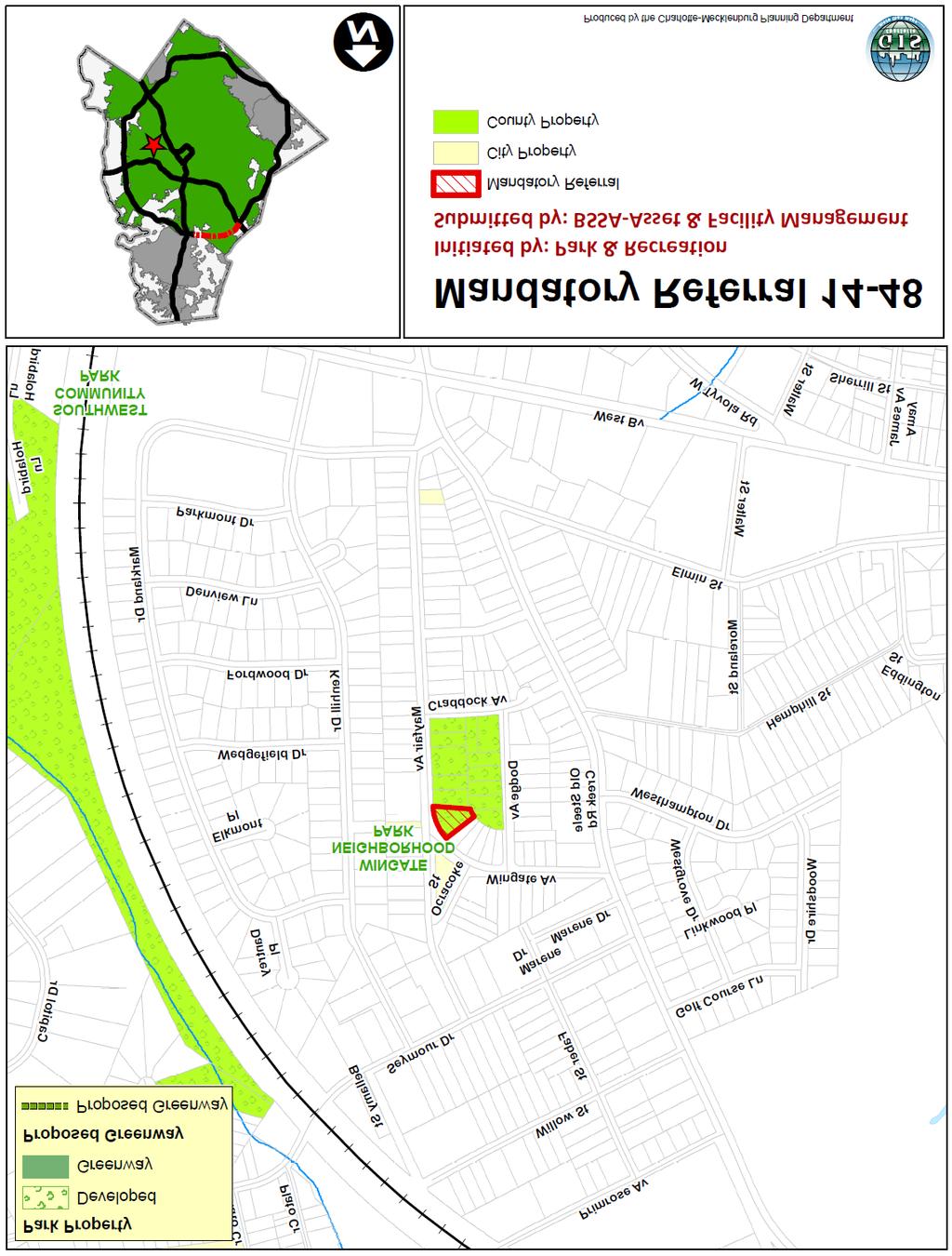
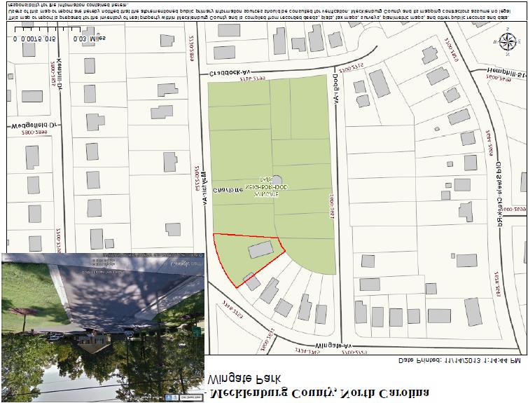
3 Charlotte-Mecklenburg Planning Commission Planning Committee Meeting Agenda June 16, :00 p.m. CMGC 2 nd Floor, Room Call to Order and Introductions 2. Approve May 19, 2015 Minutes. Attachment 1 3. Recommendation on the Refined Draft Prosperity Hucks Area Plan Background: The Planning Committee received public comments on the Refined Draft Prosperity Hucks Area Plan at their May 19, 2015 meeting. Staff reviewed changes to the draft plan and several residents spoke in support of the refined draft plan. Click here or visit charlotteplanning.org to view the refined draft plan and Implementation Guide. Staff Resource: Action Requested: Kent Main, Planning Recommend approval of the Refined Draft Prosperity Hucks Area Plan 4. M.R. #14-48: Proposal by Mecklenburg County to Convey a Portion of Wingate Neighborhood Park to the City of Charlotte Background: Mecklenburg County proposes to convey a 0.28-acre parcel located at 2701 Mayfair Avenue (Tax Parcel ) to the City of Charlotte. Several years ago, the City constructed a neighborhood community center on this parcel to serve the Wingate community. However, the City no longer operates community centers and no longer provides services from this location. This proposal will allow the City to offer the building for purchase as a single family home. Attachment 2 Staff Resources: Alberto Gonzalez, Planning Jacqueline McNeil, County Asset and Facility Management Action Requested: Approve Planning staff s recommendation for M.R. # M.R. #15-20: Proposal by Mecklenburg County to Acquire Land Located Land off Old Bell Road for the Expansion of McAlpine Creek Greenway in south Charlotte Background: Mecklenburg County proposes to acquire the rear portion of a site (Tax Parcel (0.27 acres)) located at 216 Old Bell Road along McAlpine Creek (the single family home on the front portion of this parcel will remain (0.57 acres)). The property will be assembled with other properties along the creek for construction of the McAlpine Creek Greenway trail from Sardis Road to Providence Road. Attachment 3 Staff Resources: Kent Main, Planning Katie Daughtry, County Asset and Facility Management Action Requested: Approve Planning staff s recommendation for M.R. #15-20.
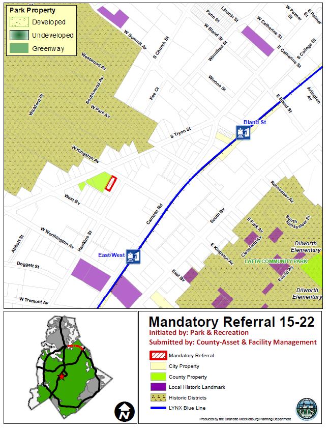
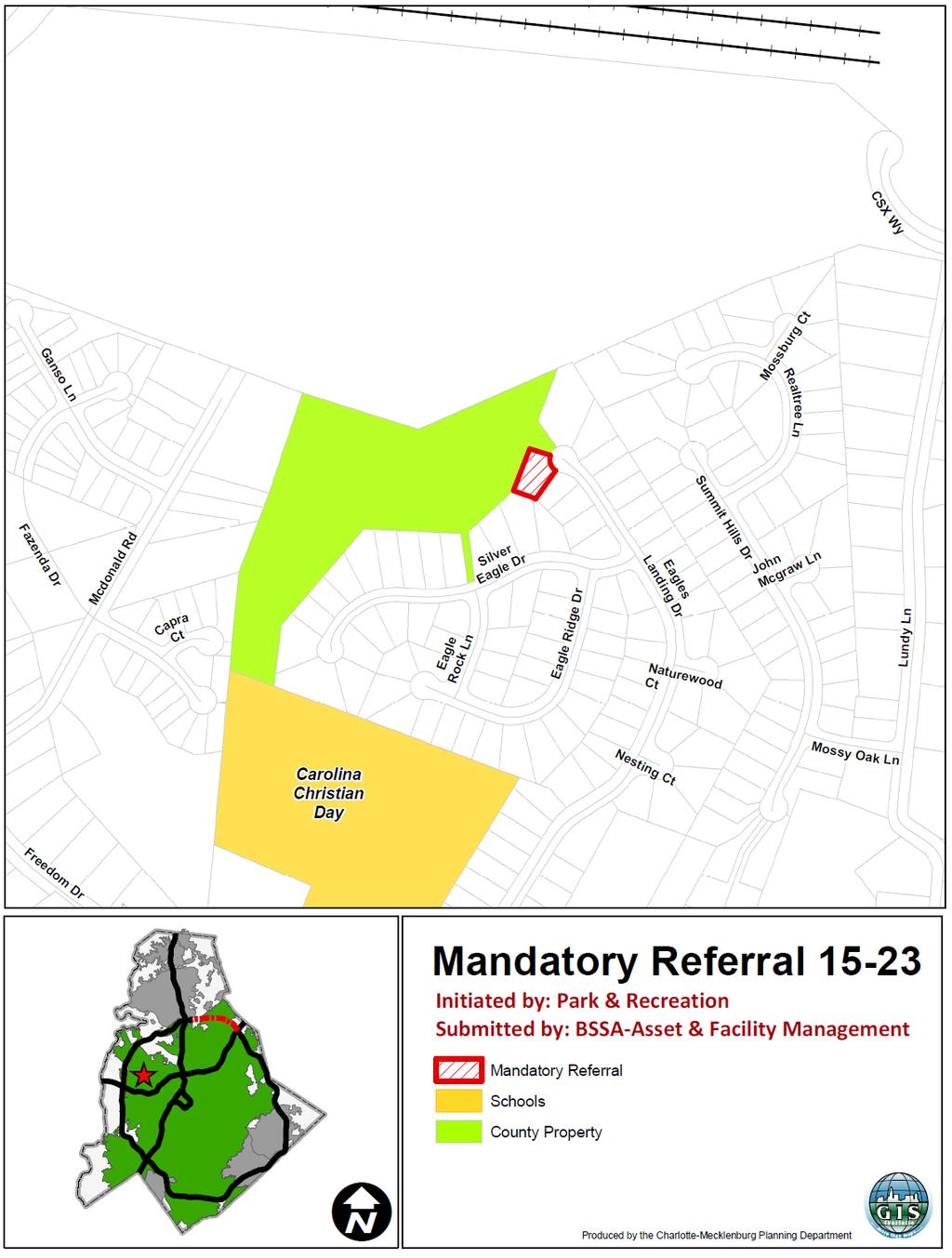
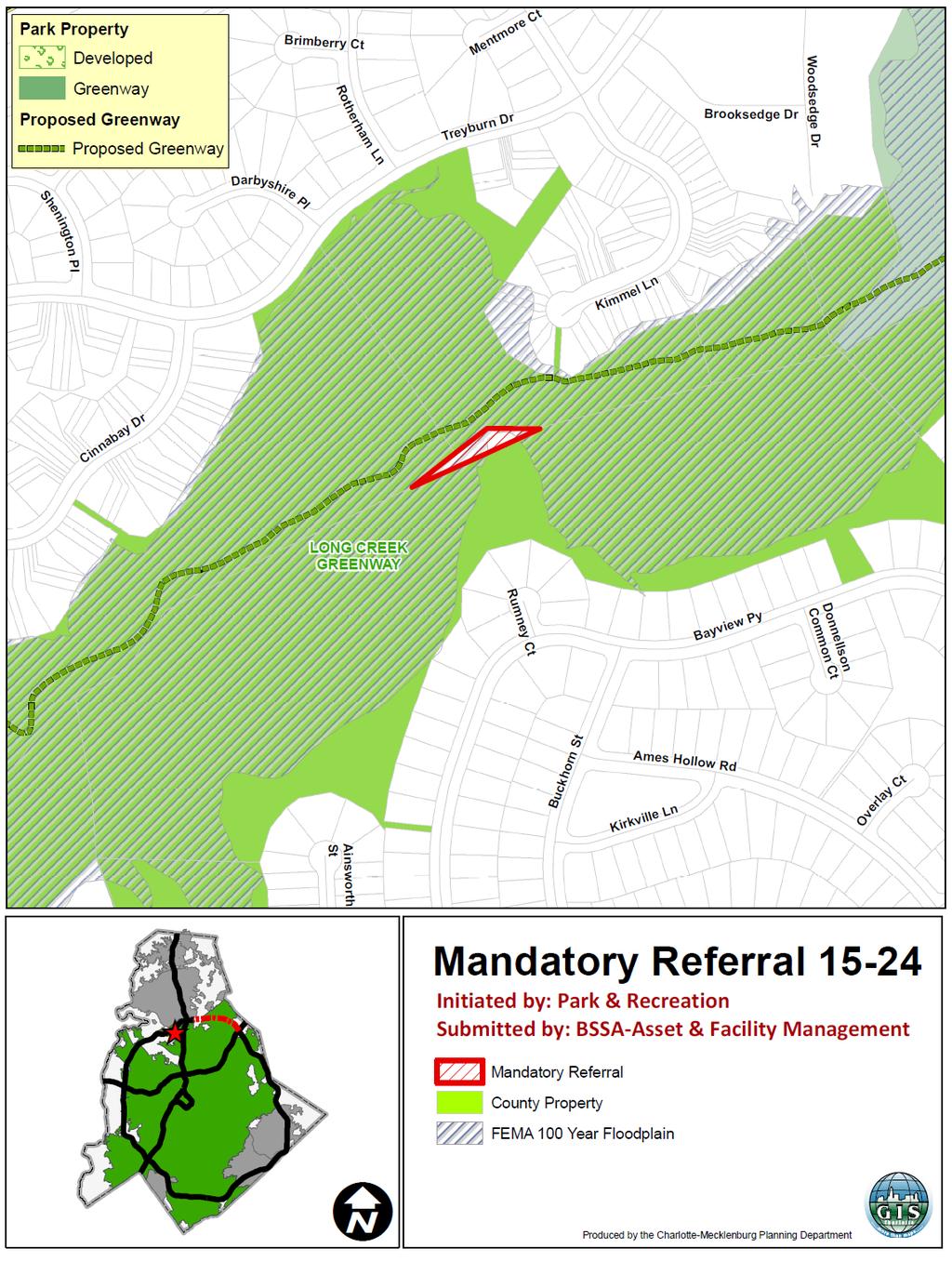
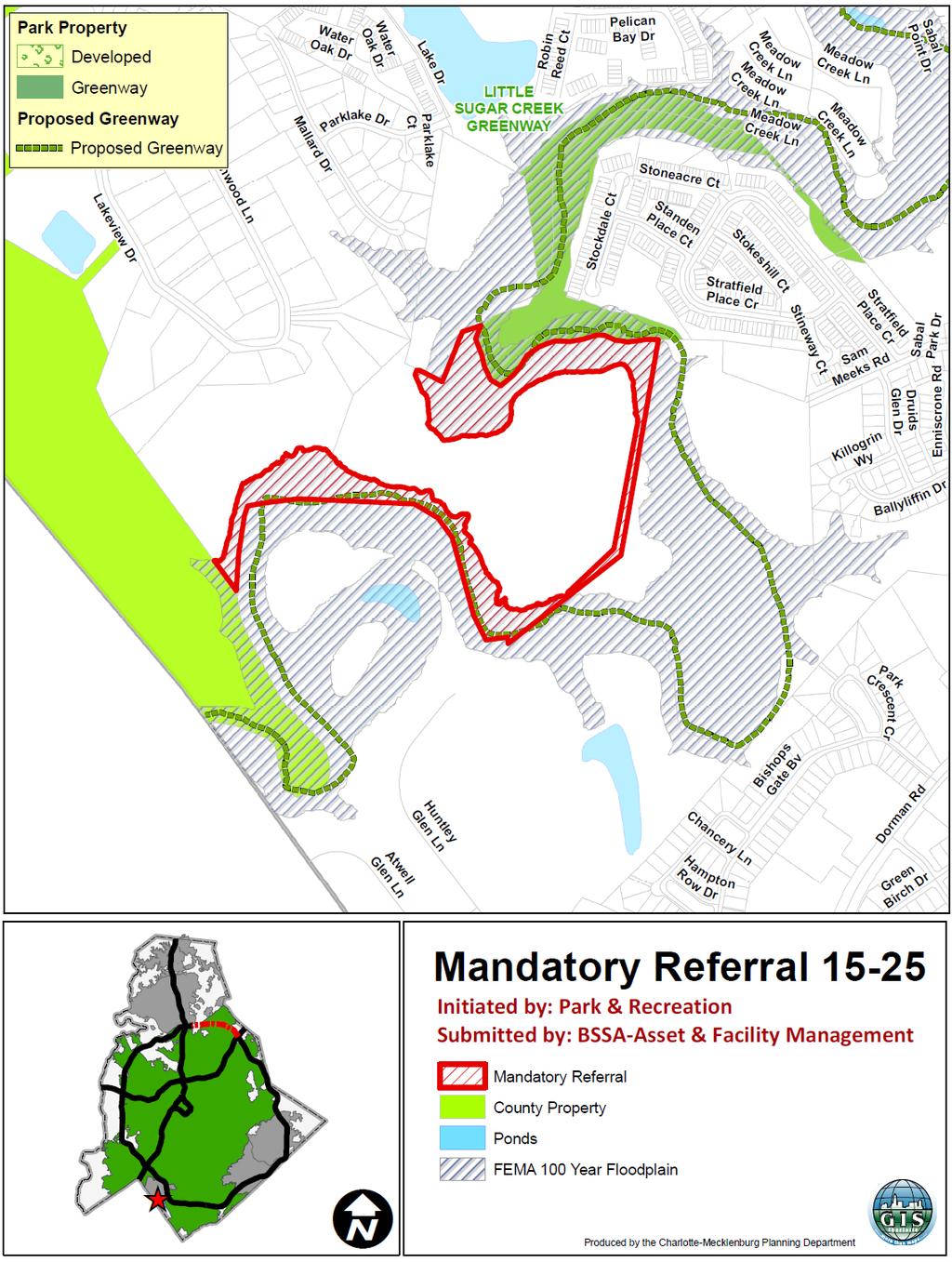
4 6. M.R. #15-22: Proposal by Mecklenburg County to Acquire Land Located on West Kingston Avenue for Wilmore Centennial Park in SouthEnd Background: Mecklenburg County proposes to acquire a 0.17 acre site located at 205 West Kingston Avenue (Tax Parcel ). The property will be assembled with other properties in this area for development of Wilmore Centennial Park. Attachment 4 Staff Resources: Kent Main, Planning Katie Daughtry, County Asset and Facility Management Action Requested: Approve Planning staff s recommendation for M.R. # M.R. #15-23: Proposal by Mecklenburg County to Acquire Land for Addition to Eagles Landing Neighborhood Park in West Charlotte Background: Mecklenburg County proposes to acquire approximately 0.44 acres located at 1204 Eagles Landing Drive (Tax Parcel ). The property will be assembled with adjacent Eagles Landing Neighborhood Park property for construction of a portion of the park. Attachment 5 Staff Resources: Alberto Gonzalez, Planning Katie Daughtry, County Asset and Facility Management Action Requested: Approve Planning staff s recommendation for M.R. # M.R. #15-24: Proposal by Mecklenburg County to Acquire Land Located in the Northlake Area for the Expansion of Long Creek Greenway Background: Mecklenburg County proposes to acquire 0.21 acres of land located adjacent to Long Creek Greenway (Tax Parcel ) for future construction of the greenway trail. Attachment 6 Staff Resources: Alberto Gonzalez, Planning Katie Daughtry, County Asset and Facility Management Action Requested: Approve Planning staff s recommendation for M.R. # M.R. #15-25: Proposal by Mecklenburg County to Acquire Land Located in Pineville for the Expansion of Little Sugar Creek Greenway Background: Mecklenburg County proposes to acquire 3.0 acres (Tax Parcels & p/o) in the Town of Pineville along Little Sugar Creek. The property will eventually be assembled with other properties along the creek for construction of the Little Sugar Creek Greenway trail from I-485 to the South Carolina state line. Attachment 7 Staff Resources: Jonathan Wells, Planning Jacqueline McNeil, County Asset and Facility Management Action Requested: Approve Planning staff s recommendation for M.R. #
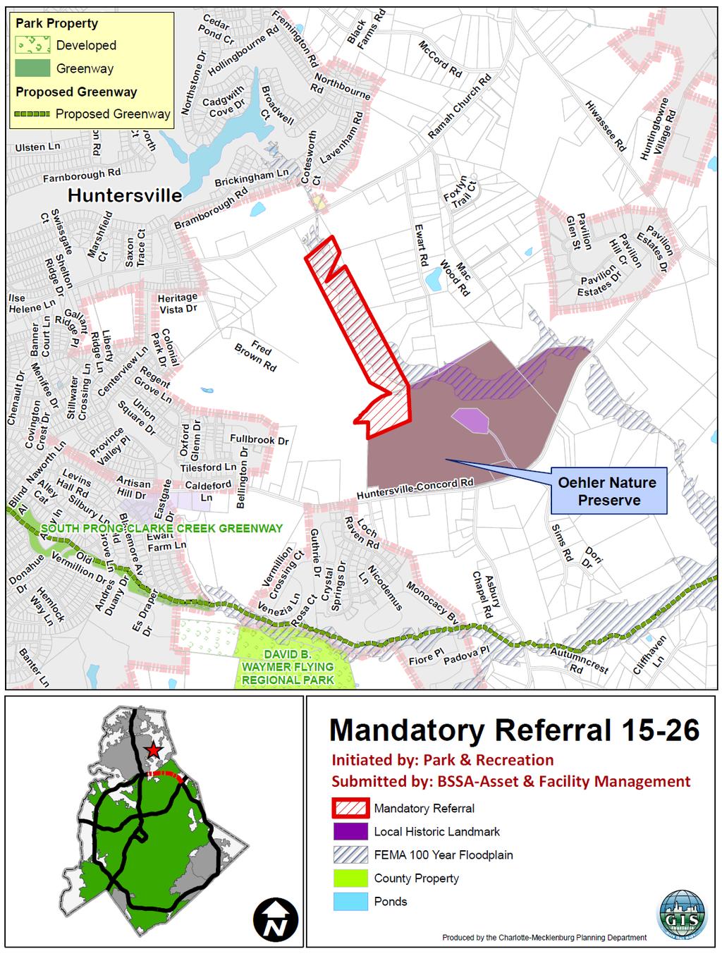
5 10. M.R. #15-26: Proposal by Mecklenburg County to Acquire Land for the Expansion of Oehler Nature Preserve and North Prong Clark Creek Greenway in Huntersville Background: Mecklenburg County proposes to acquire.44 acres located between Ramah Church and Huntersville-Concord roads (Tax Parcel ) in the Town of Huntersville s ETJ for expansion of the Oehler Nature Preserve and North Prong Clark Creek Greenway. Attachment 8 Staff Resources: Jonathan Wells, Planning Jacqueline McNeil, County Asset and Facility Management Action Requested: Approve Planning staff s recommendation for M.R. # Area Plan Status and Meeting Report Area Plans Refined Draft Prosperity Hucks Area Plan Assigned Scheduled Meeting Commissioner Nancy Wiggins City Council - Public Comment Monday, June 22, :00 pm Background: Committee members will provide an update on area plans. Action Requested: For Committee discussion. 12. Adjourn 3
6
7 Charlotte-Mecklenburg Planning Commission Planning Committee Meeting Minutes May 19, :00 p.m. CMGC 2 nd Floor, Room 280 ATTACHMENT 1 DRAFT Attendance: Commissioners Present: Chairperson Tony Lathrop, Vice-Chairperson Randy Fink, Commissioners Emma Allen, Tom Low and Cozzie Watkins Commissioners Absent: Commissioner Nancy Wiggins Planning Staff Present: Pontip Aphayarath, Garet Johnson, Sonda Kennedy, Melony McCullough, Kent Main and Jonathan Wells Other Staff Present: Jennifer Morrell, County Asset and Facility Management and Scott Correll, Charlotte Department of Transportation Call to Order and Introductions Chairperson Tony Lathrop called the meeting to order at 5:10 p.m., welcomed those present and asked everyone to introduce themselves. Approve April 21, 2015 Minutes A motion was made by Commissioner Emma Allen and seconded by Vice-Chairperson Randy Fink to approve the April 21, 2015 minutes. The vote was unanimous. Chairperson Tony Lathrop recognized Council member Phipps, who briefly stopped by the meeting. He thanked him for his service on the Planning Commission and interest in the Prosperity Hucks planning process. Council member Phipps greeted everyone and stated that he highly recommends support of the refined draft Prosperity Hucks Area Plan. M.R. #15-19: Proposal by Mecklenburg County to Acquire Land Located along Little Sugar Creek (in south Charlotte, near Archdale Drive) Kent Main (Planning) gave an overview and background information on Mecklenburg County s proposal to acquire approximately 18 acres of land located along the westerly side of Little Sugar Creek south of Archdale Drive. The property will be assembled with other properties along the creek for construction of the Little Sugar Creek trail from Tyvola Road to Huntingtowne Farms Park. This trail will be a part of the Cross Charlotte Trail, which will extend from Pineville to the Cabarrus County line. This acquisition is consistent with the County s 2008 Parks Master Plan that recommends more greenway trails and is also on the County s Park and Recreation Master Plan. The proposal is consistent with the South District Plan.
8 Mr. Main noted that there are sewer easements and a sewer treatment plant near the property. Vice-Chairperson Fink asked if the Committee should base their recommendation on the sewer easements. Jennifer Morrell (County Asset and Facility Management) stated that they are working with Charlotte Water to determine which sewer easements are needed. Commissioner Low asked if the Celanese site is developed with multi-family land uses. Mr. Main explained that the property is developed with apartments and townhomes. A motion was made by Commissioner Allen and seconded by Commissioner Watkins to approve Planning staff s recommendation for Mandatory Referral # The vote was unanimous to approve staff s recommendation for Mandatory Referral # Receive Public Comment on the Refined Draft Prosperity Hucks Area Plan Mr. Main explained the planning process to date, shared background information and gave an overview of the refined draft Prosperity Hucks Area Plan recommendations. He reminded the Committee that they made a recommendation to adopt the draft plan in January However, a number of issues emerged prior to City Council action on the previous draft and staff was directed to work with residents to address their concerns. Public concerns primarily centered on multi-family development, the location and types of retail uses, details of design guidance and open space. Staff has worked with residents over the past several months to address their concerns and to develop the refined draft Prosperity Hucks Area Plan. Mr. Main gave an overview of the refined draft plan. Commissioner Allen asked staff how many people attended the April 15 th public meeting. Mr. Main answered approximately 100. Commissioner Allen said that although attendance was good, she would like to caution staff about scheduling meetings on April 15. It may be difficult for some people to attend a meeting on this date. Chairperson Lathrop thanked those in attendance for taking the time to attend this meeting and share their comments. He reviewed the guidelines for public comments and emphasized that each person has three minutes to speak. There were six speakers. Denny Abbey, Highland Creek, stated that he was a part of the core group that worked with Planning staff on the plan. He thanked staff for working with the community and thinks that better decisions can be made from recommendations in the refined draft plan. Theresa Rosa, Highland Creek, was also a part of the core group. She echoed Mr. Abbey s comments. She stated that this is a much better plan and that she was proud to work with staff and the community. Gequeta Ferrell, Davis Lake/Eastfield, stated that she and her husband are new to the area but are excited about the plan. She was concerned about traffic congestion but is glad to know that this will ultimately be a walkable community. She further stated that participating in the planning process was a great experience and thanked everyone for their efforts. 2
9 Bryant Shorter, Davis Lake/Eastfield, expressed his appreciation, especially to Mr. Main. He stated that he attended the meetings and found them to be transparent and intimate. He commented that the refined draft plan takes into account the community s concerns. Chris Martin, Highland Creek, moved to the area in He shared his appreciation of Mr. Main for taking more time to work with the community on a revised plan. He is very satisfied with the final results. He thinks it is very important that people are heard and their concerns are addressed. Robert Williams, Davis Lake/Eastfield moved to the area in He expressed his concern about traffic issues during peak hours on Allen A. Browne Road, which is off of Browne Road. He is concerned about safety and thinks a traffic signal would be helpful. He added that he attended the Prosperity Hucks meetings and appreciated the opportunity to have input. Chairperson Lathrop again thanked the speakers for their attendance and support of this planning effort. He also thanked staff for going the extra mile to make this a great process. Commissioner Allen also thanked the residents for their presence. She emphasized the Commission s desire for more community engagement. She reiterated her appreciation for residents being engaged, hanging in there and coming to express their support of the plan. She also thanked staff for working with the community. She suggested that Charlotte Department of Transportation look into the traffic concern on Browne Road. Commissioner Watkins said that whatever staff did during this process needs to be duplicated. Chairperson Lathrop said that it is exciting to see plans for what looks like a neat and walkable town center that can be an example for other areas of the City. He stated that the purpose of today s meeting is to receive comments only and that action on this plan will be at a later date. Area Plan Status and Meeting Report The previous agenda item addressed this item. Adjourned at 5:45 p.m. 3
10
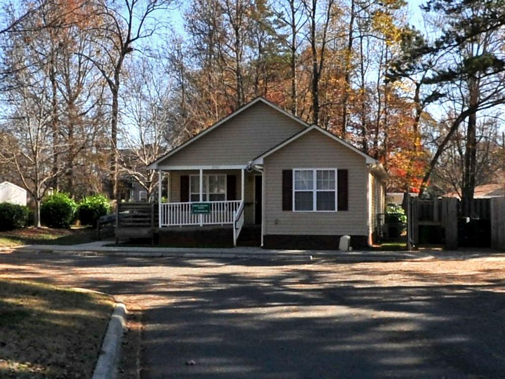
11 ATTACHMENT 2 Submitted by: Jacqueline McNeil, BSSA-Asset and Facility Management Initiated by: Jim Garges, Director, Park & Recreation Dept. MANDATORY REFERRAL REPORT NO Proposed Conveyance of a Portion of Wingate Neighborhood Park to the City of Charlotte PROJECT PROPOSAL AND LOCATION: Mecklenburg County proposes to convey the 0.28-acre Tax Parcel located at 2701 Mayfair Avenue to the City of Charlotte. Between 1996 and 2001, the City s Neighborhood Development Department acquired 17 parcels in the Wingate neighborhood of west Charlotte as part of a neighborhood revitalization program. Thirteen of those parcels were donated to the County in 2001 and became Wingate Neighborhood Park. The remaining four parcels were developed with single-family homes under the US Housing and Urban Development HOME housing affordability program. Subsequent to the transfer of the 13 parcels to Mecklenburg County, the City constructed a neighborhood community center on parcel (a parcel that was one of the 13 parcels incorporated into the park property) to serve the residents of the community. The City is no longer operating community centers and, as a result, is no longer providing services from this location. The former community center building is constructed in the style of a single family home and has been well maintained. Transfer of the parcel to the City will allow the City to offer the building for purchase as a single family home. The parcel is zoned R-5 (single family residential) under the City of Charlotte s Zoning Ordinance. The property is located within a single family residential area, with the Wingate Park located south and east of the property. PROJECT JUSTIFICATION: Since the City is no longer operating community centers and the former community center facility is built in the style of a home, the County has agreed to transfer the property back to the City which will offer the property for purchase and reuse as a single family home. Park and Recreation has determined that conveyance of the parcel to the City and placement back into the housing stock for the area will not negatively impact the park or park operations. The 0.28-acre parcel represents only a small segment of the 2.74-acre neighborhood park. CONSISTENCY WITH ADOPTED PUBLIC POLICIES: Conveyance of this property is consistent with the City s and the County s goals of increasing the supply of workforce housing within the City and stabilizing neighborhoods. While the conveyance of the parcel will result in a slight decrease in parkland, the County has determined that this small decrease will not result in a detrimental impact on Wingate Park or on the County s ability to fulfill its park and recreation mission. Additionally, the goal of providing housing in this manner is complementary to Park and Recreation s goal of shaping the surrounding community by providing amenities that contribute to the value of neighborhoods and the City as a whole. CONSISTENCY WITH ADOPTED LAND USE PLANS: The Central District Plan (1993) recommends Single Family up to 5 DUA as the adopted land use for this parcel, and the surrounding area. The property is zoned R-5 (Single Family), however due to the building s location on the parcel it won t meet the minimum rear yard required under the R-5 zoning district. The driveway and parking lot would also need to be removed, because it doesn t meet the development standards under the R-5 zoning district. PROJECT IMPACT: Conveyance of this parcel to the City will result in an increase in the supply of reasonably-priced homes in the Wingate neighborhood. Park and Recreation has determined that it will not negatively impact Wingate Park or park operations. RELATIONSHIP TO OTHER PUBLIC OR PRIVATE PROJECTS: There are no known public or private projects that will be impacted by the conveyance of this parcel to the City as well as the ultimate goal of placing the improvements on the parcel into the housing stock in the neighborhood. ESTIMATED PROJECT COMPLETION DATE: The conveyance of this parcel to the City is expected to be completed by the end of December JOINT USE TASK FORCE REVIEW COMMENTS: This matter was discussed at the May 6, 2015 Joint Use Task Force meeting and comments were made regarding the driveway and parking lot needing to be removed, and the need to conduct Departmental polling. PLANNING STAFF RECOMMENDATION: Planning Department staff recommends approval of the conveyance of this property for future residential use, once outstanding issues (discussed above under Consistency With Adopted Land Use Plans) regarding the non-conforming structure are resolved. CMPC PLANNING COMMITTEE RECOMMENDATION: Staff resource: Alberto Gonzalez
12
13
14
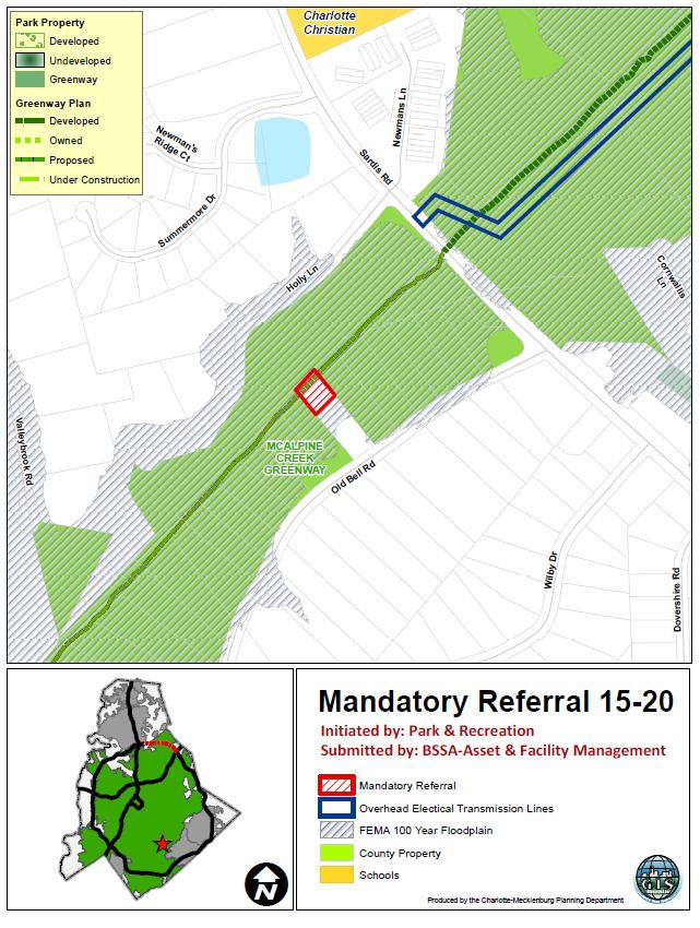
15 ATTACHMENT 3 Submitted by: Katie Daughtry, Asset and Facility Management Initiated by: Jim Garges, Director of Mecklenburg County Park and Recreation MANDATORY REFERRAL-REPORT NO Proposed Acquisition of Land off Old Bell Road in Charlotte for McAlpine Creek Greenway PROJECT PROPOSAL AND LOCATION: Mecklenburg County proposes to acquire the rear portion of tax parcel (± acres) in south Charlotte at 216 Old Bell Road along McAlpine Creek. The property will eventually be assembled with other properties along the creek for the construction of McAlpine Creek Greenway trail from Sardis Road to Providence Road. The single family home on the front portion of this parcel (to contain 0.57 acres following subdivision of the area desired by the County) will continue to remain following County acquisition. The property is a single-family residence and is zoned R-3 (Single Family Residential), according to the City of Charlotte Zoning Ordinance. The property is surrounded by residential uses and vacant land previously assembled by the County to serve as future greenway. The property lies entirely within the 100-year floodplain. PROJECT JUSTIFICATION: McAlpine Creek Greenway is a northeast to southwest running greenway corridor in the southern portion of the County. At build out, this greenway trail will connect McAlpine Creek Regional Park off Monroe Road in Charlotte to South Carolina, linking to Four Mile Creek Greenway, McMullen Creek Greenway, Little Sugar Creek Greenway and various residential and commercial developments along the way. Linking to Little Sugar Creek Greenway is a priority for the City s Cross Charlotte Trail project. McAlpine Creek Greenway is also part of the planned Carolina Thread Trail system. Park and Recreation would like to acquire this property for the future construction of McAlpine Creek Greenway trail. This section of trail is an FY17 Capital Improvement Project. McAlpine Creek is an identified greenway corridor in the 2008 Park and Recreation Master Plan. Greenway trails are by far the most requested form of recreation by Mecklenburg County residents. Acquisition of the property will also help to preserve land for habitat and water quality purposes. CONSISTENCY WITH ADOPTED PUBLIC POLICIES: This project is consistent with the 2008 Mecklenburg County Park and Recreation Master Plan objectives which identified the need for expanding the County s greenway system. CONSISTENCY WITH ADOPTED LAND USE PLANS: The South District Plan (1993) recommends the subject for Greenway and Open Space use based on its floodplain designation. The portion of the parcel not to be acquired, where the single family home is located, is just outside of the floodplain and floodway lines, and is shown as single family residential. PROJECT IMPACT: The construction of McAlpine Creek Greenway trail will allow pedestrians and cyclists to reach major destinations such as parks, other greenways, shopping destinations and restaurants. This is a significant infrastructure project that will provide an important form of recreation and alternate form of transportation for many County residents. RELATIONSHIP TO OTHER PUBLIC OR PRIVATE PROJECTS: Linking greenways to the Little Sugar Creek Greenway is a priority for the City s Cross Charlotte Trail project. The McAlpine Creek Greenway is also part of the planned Carolina Thread Trail system. Charlotte Water (formerly CMUD) has recently completed a major sewer outfall construction project on the adjoining property that will serve as the location of the future greenway. ESTIMATED PROJECT COMPLETION DATE: This project is for land acquisition only and is expected to be completed by Summer Construction of this segment of the greenway is planned as a FY2017 Capital Improvement Project. JOINT USE TASK FORCE REVIEW COMMENTS: The Joint Use Task Force met on June 3, No comments were offered on this proposal. PLANNING STAFF RECOMMENDATION: The proposal is consistent with the South District Plan. It will serve a critical need in linking with other County greenway property to allow for future construction of the McAlpine Creek Greenway. As such, staff recommends approval of the proposal. CMPC PLANNING COMMITTEE RECOMMENDATION: Staff resource: Kent Main
16
17 ATTACHMENT 4 Submitted by: Katie Daughtry, Asset and Facility Management Initiated by: Jim Garges, Director of Mecklenburg County Park and Recreation MANDATORY REFERRAL-REPORT NO Proposed Acquisition as Addition to Wilmore Centennial Park in SouthEnd of Charlotte PROJECT PROPOSAL AND LOCATION: Mecklenburg County proposes to acquire tax parcel (± acres) in Charlotte at 205 West Kingston Avenue in the Wilmore neighborhood of Charlotte. The property will eventually be assembled with other properties in this area for the development of a neighborhood park to be called Wilmore Centennial Park. The County s vision is for the park to eventually occupy this entire block. The property is a single-family residence and is zoned B-1 (Neighborhood Business), according to the City of Charlotte Zoning Ordinance. The property is surrounded by residential uses to the east, a business to the south, County-owned property previously acquired for Wilmore Centennial Park to the west and a vacant tract to the north. There are also multifamily projects in various stages of development in the immediate vicinity. PROJECT JUSTIFICATION: The 2008 Park and Recreation Master Plan states, Neighborhood Parks ideally shall be a minimum of 2-20 acres in size and shall serve the immediately adjacent, local neighborhood. The current park site, acquired in 2012, is approximately ±0.88 acres. Acquisition of this property would increase the County s holdings in this location to ± acres, getting this park closer to the recommended minimum for a park of this kind. Once developed the park may include amenities such as a picnic shelter, benches, multi-purpose fields, ½ basketball and volleyball courts and walking trails. CONSISTENCY WITH ADOPTED PUBLIC POLICIES: This project is consistent with the 2008 Mecklenburg County Park and Recreation Master Plan objectives which identified the need for increasing the number of neighborhood parks in the County. CONSISTENCY WITH ADOPTED LAND USE PLANS: The parcel in question is subject to South End Transit Station Area Plan (2005) which recommends mixed transit supportive development. The proposed use is compatible with transit supportive development. Furthermore, the Plan encourages development of public spaces which can be used for recreation and community events. The proposed use is considered to be consistent with the adopted land use plan. PROJECT IMPACT: With the increase of people living in this area, the need for open space also increases. The development of Wilmore Centennial Park will provide that open space with a neighborhood park for the growing nearby community. RELATIONSHIP TO OTHER PUBLIC OR PRIVATE PROJECTS: There are no other public or private projects being impacted by this park project. ESTIMATED PROJECT COMPLETION DATE: This project is for land acquisition only and is expected to be completed by Summer JOINT USE TASK FORCE REVIEW COMMENTS: This matter was discussed at the June 3, 2015 Joint Use Task Force meeting and there were no comments. PLANNING STAFF RECOMMENDATION: Planning staff recommends approval of the proposed transaction. CMPC PLANNING COMMITTEE RECOMMENDATION: Staff resource: Catherine Stutts
18
19 ATTACHMENT 5 Submitted by: Katie Daughtry, Asset and Facility Management Initiated by: Jim Garges, Director of Mecklenburg County Park and Recreation MANDATORY REFERRAL-REPORT NO Proposed Acquisition for Addition to Eagles Landing Neighborhood Park in West Charlotte PROJECT PROPOSAL AND LOCATION: Mecklenburg County proposes to acquire tax parcel (± 0.44 acres) in west Charlotte at 1204 Eagles Landing Drive. The property will be assembled with adjacent Eagles Landing Neighborhood Park property for the construction of a portion of the park. The property is vacant and is zoned R-4 (Single Family Residential), according to the City of Charlotte Zoning Ordinance. The property is surrounded by residential uses to the east, south and west and the future neighborhood park to the north. PROJECT JUSTIFICATION: This construction of Eagles Landing Neighborhood Park is an approved FY14 project, and Park and Recreation is currently in design for the park. Construction on the park is anticipated to being in the fall of The park is anticipated to contain walking trails, a shelter and a play area. Construction of this park would provide a much needed neighborhood park for this area of the County. The subject parcel will be used for pedestrian access between the park and the neighborhood. CONSISTENCY WITH ADOPTED PUBLIC POLICIES: This project is consistent with the 2008 Mecklenburg County Park and Recreation Master Plan objectives which identified the need for adding to the inventory of neighborhood parks in the County. CONSISTENCY WITH ADOPTED LAND USE PLANS: The Northwest District Plan (1990) recommends single family up to 4 dwelling units per acre (DUA), for this property and the surrounding single family neighborhood. Parks and greenways are considered compatible land uses adjacent to single family, and in this case would provide a buffer with the industrial uses just north of this neighborhood. PROJECT IMPACT: The acquisition of this property will provide Americans with Disabilities Act (ADA) access to the park that is otherwise unachievable due to site constraints such as topography. Additionally, having this property will allow for a wider culvert stream crossing instead of a narrow bridge stream crossing inside the park, thereby allowing the County to get maintenance vehicles into the park. RELATIONSHIP TO OTHER PUBLIC OR PRIVATE PROJECTS: There are no other public or private projects being impacted by this park construction project. ESTIMATED PROJECT COMPLETION DATE: This project is for land acquisition only and is expected to be completed by Summer JOINT USE TASK FORCE REVIEW COMMENTS: This matter was discussed at the June 3, 2015 Joint Use Task Force meeting and no comments were provided. PLANNING STAFF RECOMMENDATION: Planning staff recommends approval of the proposed land acquisition in order to accommodate the construction of a neighborhood park. CMPC PLANNING COMMITTEE RECOMMENDATION: Staff resource: Alberto Gonzalez
20
21 ATTACHMENT 6 Submitted by: Katie Daughtry, Asset and Facility Management Initiated by: Jim Garges, Director of Mecklenburg County Park and Recreation MANDATORY REFERRAL-REPORT NO Proposed Acquisition of Land to Add to Long Creek Greenway in North Charlotte PROJECT PROPOSAL AND LOCATION: Mecklenburg County proposes to acquire tax parcel (± acres) in north Charlotte along Long Creek Greenway. The property will be assembled with adjacent Long Creek Greenway property for the future construction of the greenway trail. The property is vacant and is zoned MX-2 (INNOV) (Mixed Use), according to the City of Charlotte Zoning Ordinance. The property is surrounded by County-owned greenway property and single family residences. PROJECT JUSTIFICATION: Long Creek Greenway is the major east-west greenway corridor in the County. At build-out, Long Creek Greenway trail will extend approximately 15 miles connecting to Mallard Creek Greenway in the east and terminating at the US National Whitewater Center in the west. The design and construction of the section of Long Creek Greenway in which this parcel is located is an approved FY18 project that will run from Dixon Branch to Primm Road. CONSISTENCY WITH ADOPTED PUBLIC POLICIES: This project is consistent with the 2008 Mecklenburg County Park and Recreation Master Plan objectives which identified the need for expanding the County s greenway system. CONSISTENCY WITH ADOPTED LAND USE PLANS: The Northlake Area Plan (2008) recommended Greenway as the land use for this parcel, as it lies within the stream buffer area along Long Creek. PROJECT IMPACT: Acquiring this property will provide ownership consistency in the area for the future greenway trail construction project. RELATIONSHIP TO OTHER PUBLIC OR PRIVATE PROJECTS: Long Creek Greenway is part of the Carolina Thread Trail system. ESTIMATED PROJECT COMPLETION DATE: This project is for land acquisition only and is expected to be completed by Summer JOINT USE TASK FORCE REVIEW COMMENTS: This matter was discussed at the June 3, 2015 Joint Use Task Force meeting and provided no comments. PLANNING STAFF RECOMMENDATION: Planning staff recommends approval of the proposed land acquisition, as it is consistent with the Northlake Area Plan (2008) recommendation for this parcel. CMPC PLANNING COMMITTEE RECOMMENDATION: Staff resource: Alberto Gonzalez
22
23 ATTACHMENT 7 Submitted by: Jacqueline McNeil, County Asset & Facility Management Initiated by: Jim Garges, Director of County Park & Recreation MANDATORY REFERRAL-REPORT NO Proposed Acquisition in Pineville to add to Little Sugar Creek Greenway PROJECT PROPOSAL AND LOCATION: Mecklenburg County proposes to acquire a portion of tax parcels & (± 3.0 acres with precise acreage to be determined by a survey) in the Town of Pineville along Little Sugar Creek. The property will eventually be assembled with other properties along the creek for the construction of Little Sugar Creek Greenway trail from I-485 to the South Carolina state line. The property is currently vacant and is zoned R-15 (Single Family Residential), according to the Town of Pineville s Zoning Ordinance. The property is surrounded by residential uses to the northwest and northeast. West of the property is Lakeview Community Park which is owned by the County and leased to the Town. PROJECT JUSTIFICATION: Little Sugar Creek Greenway is the major north/south greenway corridor in the County. At build out, this greenway trail will connect South Carolina, Pineville, Uptown Charlotte and eventually Toby Creek Greenway in the University City area. It will also provide a connection to various neighborhood, community and regional parks as well as residential communities. Little Sugar Creek Greenway is also on the Carolina Thread Trail and Cross Charlotte Trail routes. Park and Recreation would like to acquire this property for the future construction of Little Sugar Creek Greenway trail. This section of trail is an FY15 Capital Improvement Project. Little Sugar Creek is an identified greenway corridor in the 2008 Park and Recreation Master Plan. Greenway trails are by far the most requested form of recreation by Mecklenburg County residents. Acquisition of the property will also help to preserve land for habitat and water quality purposes. CONSISTENCY WITH ADOPTED PUBLIC POLICIES: This project is consistent with the 2008 Mecklenburg County Park and Recreation Master Plan objectives which identified the need for expanding the County s greenway system. Additionally, Town of Pineville staff reports that acquisition of the property by the County for the intended use is consistent with the town s Hazard Mitigation Plan intended to minimize citizens and town property exposure to flooding and other natural events. CONSISTENCY WITH ADOPTED LAND USE PLANS: Pineville town staff reports that committing the subject parcel to greenway use is consistent with the town s overlay plans which recognize the importance of community amenities such as open space as a usable community feature as an element of new development. PROJECT IMPACT: The construction of Little Sugar Creek Greenway trail will allow pedestrians and cyclists to reach major destinations such as healthcare facilities, parks, other greenways, shopping destinations, restaurants and educational institutions. This is a significant infrastructure project that will provide an important form of recreation and alternate form of transportation for many County residents. RELATIONSHIP TO OTHER PUBLIC OR PRIVATE PROJECTS: There are no other known public or private projects being impacted by this greenway construction project. ESTIMATED PROJECT COMPLETION DATE: This project is for land acquisition only and is expected to be completed by the end of Summer JOINT USE TASK FORCE REVIEW COMMENTS: This matter was discussed at the June 3, 2015 Joint Use Task Force meeting and no joint use comments were offered. PLANNING STAFF RECOMMENDATION: Pineville town staff report that they are in favor of the proposed acquisition for the intended purpose. Planning staff recommends approval of the proposed transaction. CMPC PLANNING COMMITTEE RECOMMENDATION: Staff resource: Jonathan Wells
24
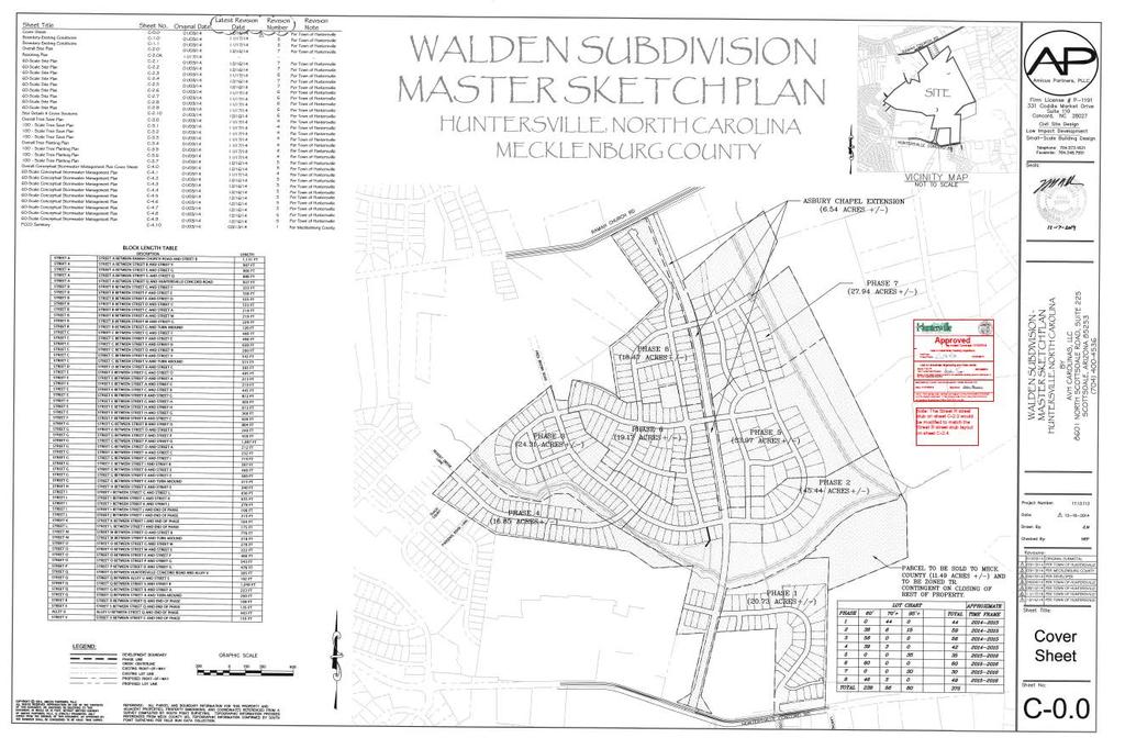
25 ATTACHMENT 8 Submitted by: Jacqueline McNeil, County Asset & Facility Management Initiated by: Jim Garges, County Park and Recreation MANDATORY REFERRAL REPORT NO Proposed Expansion of Oehler Nature Preserve & North Prong Clark Creek Greenway in Huntersville PROJECT PROPOSAL AND LOCATION: The County would like to acquire +/- 44 acres of Tax Parcel which is located between Ramah Church and Huntersville-Concord roads in the Town of Huntersville s ETJ for the expansion of Oehler Nature Preserve and North Prong Clark Creek Greenway. The property is zoned Neighborhood Residential - Conditional (NR/CD) under the Town s Zoning Ordinance. The property is vacant and lies to the northwest of the existing Oehler Nature Preserve. The western boundary of the proposed acquisition as portrayed on the accompanying map is approximate. The intent is to finalize the boundary with survey so that it matches the common boundary with the adjoining Walden subdivision (approved by the Town of Huntersville and not yet under development). PROJECT JUSTIFICATION: As the County continues to develop, the opportunity to preserve the area s natural habitat and vegetation will become increasingly rare. Acquisition of this property takes steps toward achieving continuous uninterrupted property ownership for the nature preserve. Park and Recreation has found that nature preserves function better with large uninterrupted stretches of property so that plant and animal life can be maintained and protected. Ten acres of the property is south of a southeast running tributary of North Prong Clark Creek. Closing that gap in property ownership allows Park and Recreation to better manage the plant and animal life at the nature preserve. Additionally, it will allow Park and Recreation to take steps towards restoring the property to its natural habitat. Acquisition of this property allows Park and Recreation to fulfill its goal of expanding the greenway system. North Prong Clark Creek is an adopted creek corridor on the County s Greenway Master Plan. CONSISTENCY WITH ADOPTED PUBLIC POLICIES: Acquisition of this property is consistent with the 2008 Park and Recreation Master Plan. In that plan, citizens within the County identified greenways as their top recreation desire. The Master Plan also identified a need to the protection and preservation of sensitive natural animal and plant habitats. Acquisition of this property accomplishes that goal. The proposed action is also consistent with Huntersville s 2030 Community Plan, specifically with several policies contained therein: Policy E-5: Support reduction in Vehicle Miles Travels (VMT) through investment in sidewalks, greenways, enhanced connectivity and mass transit. Policy E-7: Support land use and transportation policies that are environmentally, economically and socially sustainable. Policy T-6: Support the installation of bikeways and greenway trails connecting residential, commercial, recreational and institutional use. Policy T-8: Promote and require street connectivity in the Town of Huntersville among residential, commercial, employment and institutional uses. The proposed action is also consistent with the Huntersville Park & Recreation Plan. Huntersville has approved the Walden subdivision to the west of the subject property. The approved subdivision plan indicates a stub street for a future connector across the subject property to Ewart Road to the east of the creek. CONSISTENCY WITH ADOPTED LAND USE PLANS: The Huntersville 2030 Community Plan (adopted 2011) recommends residential development on the subject parcel. Residential land uses are generally considered to be compatible with open space and greenways.
26 PROJECT IMPACT: Acquisition of this property takes this property out of play for future development and contributes to the water quality of the Clark Creek watershed. RELATIONSHIP TO OTHER PUBLIC OR PRIVATE PROJECTS: The property will be utilized for nature preserve and greenway uses. Park and Recreation is aware of a sewer project along this creek and will have discussions with Charlotte Water about the timing and impact of that project. ESTIMATED PROJECT COMPLETION DATE: Acquisition of the property is anticipated to be completed by the end of Summer JOINT USE TASK FORCE REVIEW COMMENTS The Joint Use Task Force discussed this matter at their June 3, 2015 meeting and no joint use comments were offered. PLANNING STAFF RECOMMENDATION: The subject property is in the Town of Huntersville s planning jurisdiction. Town staff reports that the town is supportive of the proposed transaction for the intended use, subject to the following two conditions: The western boundaries of the proposed acquisition should align with the approved Walden subdivision plan Acquisition should take into account the town s goal of the eventual development of a connector street between the Walden subdivision, across the property and creek to Ewart Road to the east. Planning staff recommends approval subject to the two conditions articulated by the Town of Huntersville. CMPC PLANNING COMMITTEE RECOMMENDATION: Staff resource: Jonathan Wells
27
28
Planning Committee Agenda Packet
 Planning Committee Agenda Packet November 20, 2018 Room 280 5:00 p.m. Charlotte-Mecklenburg Planning Commission Planning Committee Meeting Agenda November 20, 2018 5 p.m. CMGC 2 nd Floor, Room 280 1.
Planning Committee Agenda Packet
 Planning Committee Agenda Packet April 21, 2015 Room 280 5:00 p.m. Charlotte-Mecklenburg Planning Commission Planning Committee Meeting Agenda April 21, 2015 5:00 p.m. CMGC 2 nd Floor, Room 280 1. Call
April 14, Sincerely,
 April 14, 2009 Chairman George Sheild, Sr. & Planning Committee Members Dear Committee Members: Attached for your review are the agenda and attachments for your regular meeting to be held on Tuesday, April
Asbury Chapel Subdivision Sketch Plan
 Asbury Chapel Subdivision Sketch Plan PART 1: PROJECT SUMMARY Applicant: NVR Inc. Project Size: +/- 76.13 acres Parcel Numbers: 02101112,02116101,02116112, 02116113 Current Zoning: Transitional Residential
PART 1: PROJECT SUMMARY. The application is Attachment A. The site plan is Attachment B.
 Belleterre Subdivision Sketch Plan Town Board 8.7.17 Belleterre Subdivision Sketch Plan PART 1: PROJECT SUMMARY Applicant: Bowman Development Project Size: +/- 20.85 acres Parcel Number: 01115104 and 01115121
PART 1: PROJECT SUMMARY. Proposed Land Use: 120 single-family lots. The application is Attachment A. The site plan is Attachment B.
 PART 1: PROJECT SUMMARY Applicant: JBH Development, LLC and Hopper Communities, INC Project Size: +/- 80.48 acres Parcel Number: 01513107, 01513108, 01513109, 01513113, 01513120, 01513121, 01513122, 01513124,
REQUEST Current Zoning: O-15(CD) (office) Proposed Zoning: TOD-M(CD) (transit oriented development mixed-use, conditional)
 (office) Proposed Zoning: TOD-M(CD) (transit oriented development mixed-use, conditional)") Rezoning Petition 2016-117 Zoning Committee Recommendation January 4, 2017 REQUEST Current Zoning: O-15(CD) (office) Proposed Zoning: TOD-M(CD) (transit oriented development mixed-use, conditional) LOCATION
Rezoning Petition 2016-117 Zoning Committee Recommendation January 4, 2017 REQUEST Current Zoning: O-15(CD) (office) Proposed Zoning: TOD-M(CD) (transit oriented development mixed-use, conditional) LOCATION
Gold Line Bus Rapid Transit Transit Oriented Development (BRTOD) Helmo Station Area Plan
 Helmo Station Area Plan") Appendix F Gold Line Bus Rapid Transit Transit Oriented Development (BRTOD) Helmo Station Area Plan Introduction and Purpose of the Plan The Gold Line Bus Rapid Transit facility is an eleven-mile dedicated
Appendix F Gold Line Bus Rapid Transit Transit Oriented Development (BRTOD) Helmo Station Area Plan Introduction and Purpose of the Plan The Gold Line Bus Rapid Transit facility is an eleven-mile dedicated
Citizen Comment Staff Response Staff Recommended Revision Planning Committee
 Citizen Comment Staff Response Staff Recommended Revision Planning Committee Area No. 1: Owner desires retail land uses. Area No. 1a: Owner of two small parcels adjacent to Area No. 1 desires retail land
Secrest Short Cut and Monroe Expressway Small Area Plan AUGUST 29, 2018
 Secrest Short Cut and Monroe Expressway Small Area Plan AUGUST 29, 2018 Background and Process Monroe Expressway will be open by the end of 2018 Union County and Indian Trail identified a need to revisit
Prosperity Hucks Area Plan. Transportation and Planning Committee May 11, 2015
 Prosperity Hucks Area Plan Transportation and Planning Committee May 11, 2015 Presentation Outline 1. Background and Location 2. Community Dialog Process 3. Activity Center Recommendations 4. Wedge Recommendations
What is a Greenway? Active Transportation. Linear Public Park. Recreation. Health and Fitness. Desirable Amenity. Access to destinations
 What is a Greenway? Active Transportation Linear Public Park Recreation Health and Fitness Desirable Amenity Access to destinations Creates a Sense of Community County standard is a 10 wide asphalt trail
Major Subdivision Sketch Plan Checklist
 This checklist provides specific requirements that are apart of the Sketch process. The entire process is described by the Huntersville Subdivision Review Process which details all the submittal and resubmittal
Staff Report and Recommendation
 Community Planning and Development Planning Services 201 W. Colfax Ave., Dept. 205 Denver, CO 80202 p: 720.865.2915 f: 720.865.3052 www.denvergov.org/cpd TO: City Council Neighborhoods and Planning Committee
Urban Planning and Land Use
 Urban Planning and Land Use 701 North 7 th Street, Room 423 Phone: (913) 573-5750 Kansas City, Kansas 66101 Fax: (913) 573-5796 Email: planninginfo@wycokck.org www.wycokck.org/planning To: From: City Planning
Welcome to the Information Session for Little Sugar Creek Greenway, Tyvola Road through Huntingtowne Farms Park
 Welcome to the Information Session for Little Sugar Creek Greenway, Tyvola Road through Huntingtowne Farms Park What is a Greenway? Active Transportation Linear Public Park Recreation Health and Fitness
Small Area Plan. South Gateway
 Small Area Plan Adopted May 12, 2008 South Gateway Purpose. The South Gateway Small Area Plan defines the City s expectations for the future of the southern entrance to the City at Interstate 85 and Highway
December 1, 2014 (revised) Preliminary Report -- Thomas Jefferson Site Evaluation
 Preliminary Report -- Thomas Jefferson Site Evaluation") December 1, 2014 (revised) TO: FROM: RE Arlington County Board Thomas Jefferson Site Evaluation Working Group by Carrie Johnson, Chair Preliminary Report -- Thomas Jefferson Site Evaluation The Thomas
December 1, 2014 (revised) TO: FROM: RE Arlington County Board Thomas Jefferson Site Evaluation Working Group by Carrie Johnson, Chair Preliminary Report -- Thomas Jefferson Site Evaluation The Thomas
The transportation system in a community is an
 7 TRANSPORTATION The transportation system in a community is an important factor contributing to the quality of life of the residents. Without a sound transportation system to bring both goods and patrons
Staff Report. Conditional Use PLANNING DIVISION COMMUNITY & ECONOMIC DEVELOPMENT. Salt Lake City Planning Commission
 Staff Report PLANNING DIVISION COMMUNITY & ECONOMIC DEVELOPMENT To: From: Salt Lake City Planning Commission Maryann Pickering, Principal Planner (801) 535-7660 Date: December 10, 2014 Re: Church of Scientology
PLANNING STAFF REVIEW
 Rezoning Petition 2016-087 Pre-Hearing Staff Analysis October 17, 2016 REQUEST Current Zoning: R-3 (single family residential), O-1(CD) (office, conditional), and INST (institutional) Proposed Zoning:
Concord Community Reuse Project Goals and Guiding Principles. Overarching Goals (OG)
") Concord Community Reuse Project Goals and Guiding Principles Overarching Goals (OG) No priority is implied by the order of presentation of the goals and guiding principles. Overarching goals for the Concord
Concord Community Reuse Project Goals and Guiding Principles Overarching Goals (OG) No priority is implied by the order of presentation of the goals and guiding principles. Overarching goals for the Concord
Tyvola & Archdale Transit Station Area Plan. May 15, 2008
 Tyvola & Archdale Transit Station Area Plan First Public Meeting May 15, 2008 Presentation Outline 1. Purpose and Process 2. Station Area Overview 3. Plan Recommendations Vision Land Use Transportation
Rezoning Petition Post-Hearing Staff Analysis July 31, 2018
 Rezoning Petition 2018-044 Post-Hearing Staff Analysis July 31, 2018 REQUEST Current Zoning: R-3 (single family residential) Proposed Zoning: UR-2(CD) (urban residential, conditional) LOCATION Approximately
Rezoning Petition Pre-Hearing Staff Analysis May 21, 2018
 Rezoning Petition 2018-028 Pre-Hearing Staff Analysis May 21, 2018 REQUEST Current Zoning: MX-1 LLWPA (mixed use district, Lower Lake Wylie Protected Area), R-3 LLWPA (single family residential, Lower
AGENDA 07/14/11 PLANNING COMMISSION Meeting
 AGENDA 07/14/11 PLANNING COMMISSION Meeting MEETING DATE: Thursday, July 14, 2011 MEETING TIME: MEETING PLACE: VIDEO: 5:30 p.m. City Council Chambers, City Hall 350 Main Street El Segundo, California 90245-0989
This Review Is Divided Into Two Phases:
 Semiahmoo Town Centre Review The purpose of this review: To review the Semiahmoo Town Centre Concept Plan, originally approved in 1993, to ensure that this centre will continue to serve the needs of South
Rezoning Petition Pre-Hearing Staff Analysis July 16, 2018
 Rezoning Petition 2018-044 Pre-Hearing Staff Analysis July 16, 2018 REQUEST Current Zoning: R-3 (single family residential) Proposed Zoning: UR-2(CD) (urban residential, conditional) LOCATION Approximately
Description of Preferred Alternative
 Chapter 2 Description of Preferred Alternative 2.1 Introduction This chapter of the programmatic Sammamish Town Center Sub-area Plan Final EIS provides a more detailed description of the Preferred Alternative
Rezoning Petition Final Staff Analysis June 18, 2018
 Rezoning Petition 2018-028 Final Staff Analysis June 18, 2018 REQUEST Current Zoning: MX-1 LLWPA (mixed use district, Lower Lake Wylie Protected Area), R-3 LLWPA (single family residential, Lower Lake
Major Development Plan
 Major Development Plan Application number: MDP2016.03 Nixon Road Subdivision Request: The applicant request that the City Council receive the planning board recommendation to approve with conditions a
Beatties Ford Road & Mt. Holly-Huntersville Road Small Area Plan
 Beatties Ford Road & Mt. Holly-Huntersville Road Small Area Plan Town of Huntersville October 2005 Town of Huntersville Planning Department 101 Huntersville Concord Road Post Office Box 664 Huntersville,
Tyvola & Archdale Transit Station Area Plan. June 5, 2008
 Tyvola & Archdale Transit Station Area Plan Second Public Meeting June 5, 2008 Presentation Outline 1. Purpose and Process 2. Station Area Overview 3. Plan Recommendations 4. Comments Received and Proposed
CHAPTER 3 VISION, GOALS, & PLANNING PRINCIPLES. City of Greensburg Comprehensive Plan. Introduction. Vision Statement. Growth Management Goals.
 CHAPTER 3 VISION, GOALS, & PLANNING PRINCIPLES Introduction The Greensburg Comprehensive Plan is intended as a working community document. A combination of long and short-term goals, this document is intended
WHEREAS, after consideration of the evidence presented at the public hearing on January 14, 2010, the Prince George's County Planning Board finds:
 R E S O L U T I O N WHEREAS, the Prince George s County Planning Board has reviewed DDS-600 requesting a departure for the location of two loading spaces without driveway access along Toledo Terrace in
3. VISION AND GOALS. Vision Statement. Goals, Objectives and Policies
 Vision Statement Queen Creek s interconnected network of parks, trails, open spaces and recreation opportunities provide safe and diverse activities and programs that sustain its unique, small town, equestrian
Planning Districts INTRODUCTION
 INTRODUCTION To facilitate detailed examination of development prospects for all areas of the community, Delano has been divided into 14 planning districts. The location of these planning districts is
General Location Annex, Rezone & Preliminary Plat Lansdowne Addition, Unit Three
 NEWFOUNDLAND I-5 Agricultural District Subject Site SUNDANCE ANDERSON Single Family Residential CHRISTY PUD Agricultural District Highway Business General Location Annex, Rezone & Preliminary Plat Lansdowne
Sherri Ferguson. President/CEO Portland Chamber of Commerce. Tennessee Certified Economic Developer Capstone Project
 Sherri Ferguson President/CEO Portland Chamber of Commerce Tennessee Certified Economic Developer Capstone Project Strategic Plan Development for the North Gateway of Portland, Tennessee The New Gateway
Public Meeting Final Recommendations August 8, 2013
 Public Meeting Final Recommendations August 8, 2013 Meeting Agenda 1. Existing Conditions 2. Plan Building Blocks & Process 3. The Plan Policies 4. What we heard 5. Next Steps Existing Conditions Existing
FOUR MILE RUN VALLEY WORKING GROUP AND CHARGE
 FOUR MILE RUN VALLEY WORKING GROUP AND CHARGE Adopted April 16, 2016 Amended July 19, 2016 Overview of Integrated Effort The overall goal of the Four Mile Run Valley (4MRV) initiative is to develop a comprehensive
C. Westerly Creek Village & The Montview Corridor
 C. Westerly Creek Village & The VISION Community Vision When the goals of the city are achieved Westerly Creek Village, a distinctive community defined by Montview Boulevard and Westerly Creek, is a strong
A citizen s guide to the. Comprehensive Plan. City of Lakeville, Minnesota 1
 A citizen s guide to the Comprehensive Plan 2008 City of Lakeville, Minnesota 1 Introduction The City of Lakeville completed an update of its Comprehensive Plan in 2008. A comprehensive plan is a tool
Rezoning Petition Pre-Hearing Staff Analysis October 15, 2018
 Rezoning Petition 2017-137 Pre-Hearing Staff Analysis October 15, 2018 REQUEST Current Zoning: R-3 (single family residential) Proposed Zoning: B-2(CD) (general business, conditional) LOCATION Approximately
Rezoning Petition Pre-Hearing Staff Analysis September 17, 2018
 Rezoning Petition 2017-043 Pre-Hearing Staff Analysis September 17, 2018 REQUEST Current Zoning: R-3 (single family residential), R-17MF (multi-family residential), and CC (commercial center) Proposed
Arlington, Virginia is a worldclass
 EXECUTIVE S U M M A RY Arlington maintains a rich variety of stable neighborhoods, quality schools and enlightened land use policies, and received the Environmental Protection Agency s highest award for
DRAFT Amsterdam/Churchill Community Plan (4/17/08) Adopted By the Gallatin County Commission
 Adopted By the Gallatin County Commission") DRAFT Amsterdam/Churchill Community Plan (4/17/08) Adopted By the Gallatin County Commission Table of Contents Acknowledgements Chapter 1: Introduction A Brief History What s Next Authority Organization
DRAFT Amsterdam/Churchill Community Plan (4/17/08) Adopted By the Gallatin County Commission Table of Contents Acknowledgements Chapter 1: Introduction A Brief History What s Next Authority Organization
East Central Area Plan
 East Central Area Plan Steering Committee Meeting January 10 th, 2019 Tears-McFarlane House Community Room East Central Area Plan Steering Committee Meeting January 10 th, 2019 CHUN Tears-McFarlane House
Town of Jamestown. Parks and Recreation Master Plan for Jamestown Park
 Town of Jamestown Parks and Recreation Master Plan for Jamestown Park Adopted December 16, 2014 Acknowledgements Town Council Keith Volz, Mayor Brock Thomas Lynn Montgomery Georgia Nixon-Roney William
CITY OF CHARLOTTESVILLE, VIRGINIA CITY COUNCIL AGENDA
 CITY OF CHARLOTTESVILLE, VIRGINIA CITY COUNCIL AGENDA Agenda Date: December 16, 2013 Action Required: Adoption of Resolution Presenter: Staff Contacts: Title: James E. Tolbert, AICP, Director of NDS James
INDEPENDENCE BOULEVARD AREA PLAN
 INDEPENDENCE BOULEVARD AREA PLAN Public Meeting October 28, 2008 Tonight s Agenda Introduction 4:00 4:05 Tom Warshauer Presentation 4:05 5:00 Blake Drury Group Exercises 5:00 5:50 All Wrap Up & Next Steps
VILLAGE OF CLEMMONS PLANNING BOARD DRAFT STAFF REPORT
 VILLAGE OF CLEMMONS PLANNING BOARD DRAFT STAFF REPORT PETITION INFORMATION Docket # C-226 Staff Megan Ledbetter Petitioner(s) JBJH Properties, LLC Owner(s) JBJH Properties, LLC Subject Property 5892-49-1766
PARTF Scoring System for Grants
 PARTF Scoring System for Grants The members of the N.C. Parks and Recreation Authority use the PARTF scoring system as one of several tools to select grant recipients. Please provide all of the information
Atlanta BeltLine Subarea 3 Master Plan Update
 Atlanta BeltLine Subarea 3 Master Plan Update April 14, 2018 Workshop Meeting 1 22 miles, connecting 45 neighborhoods 22 MILES of transit 46 MILES of streetscapes and complete streets 33 MILES of urban
Rezoning Petition Pre-Hearing Staff Analysis March 19, 2018
 Rezoning Petition 2017-171 Pre-Hearing Staff Analysis March 19, 2018 REQUEST Current Zoning: R-3 (single family residential) Proposed Zoning: MX-2 (INNOV) (mixed used, innovative) with five-year vested
The Maryland-National Capital Park and Planning Commission Prince George's County Planning Department Development Review Division
 The Maryland-National Capital Park and Planning Commission Prince George's County Planning Department Development Review Division 301-952-3530 Note: Staff reports can be accessed at www.mncppc.org/pgco/planning/plan.htm.
Silver Line CPAM UPDATE. Transportation and Land Use Committee October 14, 2016
 Silver Line CPAM UPDATE Transportation and Land Use Committee October 14, 2016 Purpose Recap Project History and Map Changes Provide Overview of CPAM Components Discuss Transportation Impacts Discuss Fiscal
Chapter 5: Natural Resources and Environment
 NATURAL RESOURCES AND ENVIRONMENT 5-1 5 Chapter 5: Natural Resources and Environment BACKGROUND AND INTENT Urban expansion represents the greatest risk for the future degradation of existing natural areas,
DRAFT PLAN PRESENTATION
 DRAFT PLAN PRESENTATION 1.23.2018 AGENDA Process Project Schedule Results from Visioning Workshop Draft Plan Highlights Concept Plans Feedback Next Steps PROJECT SCHEDULE KICK-OFF WORKSHOP August 29 th
AWH REPORT OF THE PLANNING AND DEVELOPMENT DEPARTMENT FOR APPLICATION FOR REZONING ORDINANCE TO PLANNED UNIT DEVELOPMENT
 AWH REPORT OF THE PLANNING AND DEVELOPMENT DEPARTMENT FOR APPLICATION FOR REZONING ORDINANCE TO PLANNED UNIT DEVELOPMENT MAY 8, 2014 The Planning and Development Department hereby forwards to the Planning
RESOLUTION NO. R Refining the route, profile and stations for the Downtown Redmond Link Extension
 RESOLUTION NO. R2018-32 Refining the route, profile and stations for the Downtown Redmond Link Extension MEETING: DATE: TYPE OF ACTION: STAFF CONTACT: Capital Committee Board PROPOSED ACTION 09/13/2018
Yadkin River Greenway Feasibility Study Fact Sheet Village of Clemmons, Town of Lewisville, Town of Bermuda Run
 Fact Sheet Village of Clemmons, Town of Lewisville, Town of Bermuda Run Project Background The Yadkin River Greenway Feasibility Study is a joint project with the Village of Clemmons, the Town of Bermuda
Drexel, Barrell & Co.
 Drexel, Barrell & Co. December 21, 2018 Engineers/Surveyors Boulder Colorado Springs Greeley 3 South 7 th Street Colorado Springs, Colorado 80905-1501 719 260-0887 719 260-8352 Fax El Paso County Planning
Rezoning Petition Post-Hearing Staff Analysis February 5, 2019
 Rezoning Petition 2018-053 Post-Hearing Staff Analysis February 5, 2019 REQUEST Current Zoning: R-5 (single family), B-1 (neighborhood business), I-1 (light industrial), and I-2 (general industrial) Proposed
Rezoning Transportation Analysis Petition Number: General Location Identifier:
 From: Kelsie Anderson, PE Kelsie.Anderson@charlottenc.gov 704-432-5492 Staff Reviewer: Kory Hedrick, PE, PMP Khedrick@charlottenc.gov 704-432-6511 CDOT s review of this rezoning petition is intended to
Welcome to the LYNX Blue Line Extension Transit Station Area Plans Public Workshop No. 3. Presentation will begin at 6:00 P.M.
 Welcome to the LYNX Blue Line Extension Transit Station Area Plans Public Workshop No. 3 Presentation will begin at 6:00 P.M. Meeting Agenda Blue Line Extension (BLE) Project Update LYNX Blue Line Extension
Volume 2: Implementation Plan
 Volume 2: Implementation Plan February 25 th 2002 Implementation Introduction This document outlines the steps that should be taken to implement the Washington Heights Neighborhood Plan. The City Council
LAND USE ELEMENT. Purpose. General Goals & Policies
 LAND USE ELEMENT Purpose This Land Use Element contains the goals and policies necessary to support the City s responsibility for managing land resources and guiding development through implementing regulations,
Robbinsdale LRT Station. CDI Development Guidelines. August Overview
 Robbinsdale LRT Station August 2018 Overview The City of Robbinsdale may have the coolest opportunity site along the 13 mile stretch of the Bottineau LRT corridor / Blue Line extension. Located a block
PLANNED UNIT DEVELOPMENT & SUBDIVISION STAFF REPORT Date: May 18, 2017
 & PUD-0000102-2017 PLANNED UNIT DEVELOPMENT & SUBDIVISION STAFF REPORT Date: May 18, 2017 NAME SUBDIVISION NAME Dauphin Creek Estates Subdivision Dauphin Creek Estates Subdivision LOCATION CITY COUNCIL
ADOPTED CAPITAL IMPROVEMENT PROGRAM BUDGET ARROYO PROJECTS
 ADOPTED CAPITAL IMPROVEMENT PROGRAM BUDGET ARROYO PROJECTS HAHAMONGNA FY 212-216 Capital Improvement Program Priority Description Total Estimated Costs Appropriated Through FY 211 Adopted FY 212 FY 213
Rezoning Petition Zoning Committee Recommendation May 30, 2017
 Rezoning Petition 2017-042 Zoning Committee Recommendation May 30, 2017 REQUEST LOCATION SUMMARY OF PETITION PROPERTY OWNER PETITIONER AGENT/REPRESENTATIVE COMMUNITY MEETING STATEMENT OF CONSISTENCY Current
Preliminary Subdivision Plan
 Preliminary Subdivision Plan 704-525-8000 Suite 1200 Executive Summary the east huntersville area development plan provides a series of development initiatives and public improvements for land east of
MEMO 1. INTRODUCTION PURPOSE & PROCESS REQUEST
 MEMO Date: August 22, 2017 To: Board of Commissioners From: Jason Burdette, Planning Director Re: Davidson Commons East Hotel Stakeholder Feedback 1. INTRODUCTION PURPOSE & PROCESS This memorandum summarizes
Public Workshop #2 Summary
 Public Workshop #2 Summary Project Number: Project Title: 2320.01 (R&M) MOA Parks and Recreation Muldoon Town Square Park Master Plan Subject: Muldoon Town Square Park Master Plan Public Workshop #2 Author:
DEPARTMENT OF COMMUNITY DEVELOPMENT SERVICES Planning Division m e m o r a n d u m
 DEPARTMENT OF COMMUNITY DEVELOPMENT SERVICES Planning Division m e m o r a n d u m TO: Urbana Plan Commission FROM: Kevin Garcia, Planner II DATE: October 6, 2017 SUBJECT: Plan Case Nos. 2314-PUD-17 and
13. PRELIMINARY PLAT NO MILLS FARM - Vicinity of the southeast corner of 159 th Street and Quivira Road
 13. corner of 159 th Street and Quivira Road 1. APPLICANT: HNTB Corporation is the applicant for this request. 2. REQUESTED ACTION: The applicant is requesting approval of a preliminary plat for a 383-lot
CHAPTER SPECIAL PURPOSE AND OVERLAY ZONING DISTRICTS
 Special Purpose and Overlay Zoning Districts 106.28.010 CHAPTER 106.28 - SPECIAL PURPOSE AND OVERLAY ZONING DISTRICTS SPECIAL PURPOSE AND OVERLAY ZONING DISTRICTS Sections: 106.28.010 - Purpose 106.28.020
Woodburn Comprehensive Plan Growth Management Goals and Policies
 Goal Woodburn Comprehensive Plan Growth Management Goals and Policies G-1. The City's goal is to manage growth in a balanced, orderly and efficient manner, consistent with the City s coordinated population
SHEFFIELD PARK Paulding County, GA DRI #588
 SHEFFIELD PARK Paulding County, GA DRI #588 Supplemental Information for RDC s DRI (Form 2) Review August 16, 2004 Prepared for: Mr. David Howerin Coosa Valley RDC 1 Jackson Hill Drive Rome, GA 30161 P.O.
Chapter 2: Vision, Goals and Strategies
 Chapter 2: Vision, Goals and Lake Elmo Today & Tomorrow Comprehensive Plan 2040 2 VISION, GOALS & STRATEGIES - DRAFT 4-6-2018 INTRODUCTION Comprehensive Plan Purpose Perhapse the most important objective
FOUR MILE RUN VALLEY WORKING GROUP AND CHARGE Adopted April 16, 2016 Amended July 19, 2016
 FOUR MILE RUN VALLEY WORKING GROUP AND CHARGE Adopted April 16, 2016 Amended July 19, 2016 Working Group Charge The Working Group is charged by the County Board to collaborate with staff to provide commission,
Citizen Advisory Committee Meeting #3.2
 Citizen Advisory Committee Meeting #3.2 August 10, 2016, 7:00 p.m. to 9:00 p.m. Police Department Conference Room, 7301 Hanna Street, Gilroy, CA 95020 Meeting Summary I. Call to Order Members present:
ARLINGTON COUNTY, VIRGINIA
 ARLINGTON COUNTY, VIRGINIA County Board Agenda Item Meeting October 15, 2005 DATE: September 28, 2005 SUBJECT: Request to Advertise the adoption of the 2005 Clarendon Sector Plan C. M. RECOMMENDATION:
PLANNING COORDINATING COMMITTEE
 PLANNING COORDINATING COMMITTEE Fall Meeting/Luncheon Welcome! October 16, 2009 PLANNING COORDINATING COMMITTEE Fall Meeting/Luncheon WELCOME! WELCOME! October 16, 2009 October 16, 2009 Agenda I. Lunch/Socialize
RECREATION AND OPEN SPACE ELEMENT GOALS, OBJECTIVES, AND POLICIES
 RECREATION AND OPEN SPACE ELEMENT GOALS, OBJECTIVES, AND POLICIES Goal 7 To provide park facilities, recreation programs, and open space resources that are safe, adequate, and accessible to all City residents,
The West Vaughan Employment Area Secondary Plan Policies
 Part 2: The West Vaughan Employment Area Secondary Plan Policies 2.1 General Policies It is the policy of Council: 2.1.1. That the West Vaughan Employment Area (the WVEA), identified on Schedule 1, will
EXHIBIT A. Tax Increment Reinvestment Zone No. 1 (Town Center) First Amended Project Plan 1
 First Amended Project Plan 1") EXHIBIT A Tax Increment Reinvestment Zone No. 1 (Town Center) First Amended Project Plan 1 1 As amended by Resolution No. 2008-02-001(TR1R) of the Tax Increment Reinvestment Zone No.1, and approved to
EXHIBIT A Tax Increment Reinvestment Zone No. 1 (Town Center) First Amended Project Plan 1 1 As amended by Resolution No. 2008-02-001(TR1R) of the Tax Increment Reinvestment Zone No.1, and approved to
Little Neck Planning Area
 Little Neck Planning Area Current Reality The Little Neck Planning Area is characterized by established residential neighborhoods, Town Center and Pembroke. The Eastern and Western Branches of the Lynnhaven
Drexel, Barrell & Co.
 Drexel, Barrell & Co. June 18, 2018 Engineers/Surveyors Boulder Colorado Springs Greeley 3 South 7 th Street Colorado Springs, Colorado 80905-1501 719 260-0887 719 260-8352 Fax El Paso County Planning
A BLUEPRINT FOR BROCKTON A CITY-WIDE COMPREHENSIVE PLAN
 A BLUEPRINT FOR BROCKTON A CITY-WIDE COMPREHENSIVE PLAN Public Meeting October 2016 1 Plan Summary and Discussion Public Meeting May 4 2017 City of Brockton Bill Carpenter, Mayor Department of Planning
This page intentionally blank.
 This page intentionally blank. Parks, Recreation, and Open Space Chapter Relationship to Vision Vision Parks, Recreation and Open Space Chapter Concepts County Government. County government that is accountable
SECTION II SECTION II STATEMENT OF GOALS, OBJECTIVES, PRINCIPLES, ASSUMPTIONS, POLICIES AND STANDARDS
 STATEMENT OF GOALS, OBJECTIVES, PRINCIPLES, ASSUMPTIONS, POLICIES AND STANDARDS 1 2 STATEMENT OF GOALS, OBJECTIVES, PRINCIPLES, ASSUMPTIONS, POLICIES AND STANDARDS INTRODUCTION The New Jersey Municipal
Site Plan Review Committee June 5, 2007
 CITY OF ANDOVER SITE PLAN REVIEW COMMITTEE June 5, 2007 MINUTES The Site Plan Review Committee met for a regular meeting on Tuesday, June 5, 2007 at the Andover Central Park Lodge located at 1607 E. Central,
VILLAGE OF CLEMMONS PLANNING BOARD DRAFT STAFF REPORT. Single Family Residential, Townhomes
 VILLAGE OF CLEMMONS PLANNING BOARD DRAFT STAFF REPORT PETITION INFORMATION Docket # C-212 Staff Megan Ledbetter Petitioner(s) Peacehaven Development LLC Owner(s) Larry Jarvis, William Alexander and Peacehaven
R E S O L U T I O N. Single-Family Residence/ Church. 2,488 sq. ft. 2,488 sq. ft. Area Parking Required: Church
 R E S O L U T I O N WHEREAS, the Prince George s County Planning Board is charged with the approval of Detailed Site Plans pursuant to Part 3, Division 9 of the Zoning Ordinance of the Prince George s
1. Parks & Recreation Neighborhood Parks Community Parks Special Use Sites 2. Open Space 3. Trails
 Appendix A: Park Classifications The intent of parks and recreation classifications is to aid in making acquisition and design decisions for park sites, facilities and the organization of recreation space
Sanford/Lee County Technical Review Committee (TRC) DEADLINES & MEETING DATES
 DEADLINES & MEETING DATES") Sanford/Lee County Technical Review Committee (TRC) DEADLINES & MEETING DATES The following 2019 information is based on the information available to staff at the time of creation. Dates & time may change
Sanford/Lee County Technical Review Committee (TRC) DEADLINES & MEETING DATES The following 2019 information is based on the information available to staff at the time of creation. Dates & time may change
The Illinois Department of Transportation and Lake County Division of Transportation. Route 173, including the Millburn Bypass
 The Illinois Department of Transportation and Lake County Division of Transportation welcome you to this Public Hearing for U.S. Route 45 from Illinois Route 132 to Illinois Route 173, including the Millburn
EXECUTIVE SUMMARY DRAFT CHAPTER 1 INTRODUCTION EXECUTIVE SUMMARY
 CHAPTER 1 EXECUTIVE SUMMARY INTRODUCTION Through the joint efforts of the City of Tulsa planning staff and the Land Services division of Indian Nations Council of Governments (INCOG), the Berryhill Land