Boyce L. Whatley. Wayne Sibley Bill Houston Jason Kyle Joe Frizzell Hank Miller Steve Massey
|
|
|
- Marion Rodgers
- 6 years ago
- Views:
Transcription
1
2 MAYOR Boyce L. Whatley CITY COUNCIL Wayne Sibley Bill Houston Jason Kyle Joe Frizzell Hank Miller Steve Massey PARK BOARD MEMBERS Gary Hensel (Chairman) Mark Fletcher R. Greg Durston Ted T.J. Henley George Branam David Stanton Chris Whitt Jon Conley Angela Stephens STAFF MEMBERS Acknowledgments Don Hastings City Manager John Garfield Director of Planning Jim Berman Park & Recreation Manager Ryan Spencer Comprehensive Planning Manager
3 Table of Contents I. INTRODUCTION... 1 HISTORICAL BACKGROUND... 1 PREVIOUS PARK PLANNING STUDIES... 1 GOALS & OBJECTIVES... 1 POLICIES & ORDINANCES... 4 PLAN DEVELOPMENT PROCESS... 4 II. INVENTORY OF AREAS & FACILITIES... 5 CITY OF MIDLOTHIAN PARKS... 5 EXISTING NEIGHBORHOOD PARKS... 5 Civic Center Park... 5 Kimmel Park... 6 Margie Webb Park... 6 Mountain Peak Community Park... 7 Ridgeview Park... 7 EXISTING COMMUNITY PARKS... 8 Hawkins Spring Park... 8 Jaycee Park... 8 Midlothian Sports Complex... 9 EXISTING SPECIAL USE PARKS... 9 Back Alley Plaza... 9 Heritage Park Mockingbird Nature Park Triangle Park UNDEVELOPED PARK LAND Table 1: Park Facility Inventory Plate 1: Existing Parks III. FACTORS INFLUENCING PLANNING FOR PARKS TRANSPORTATION ROUTES & THOROUGHFARES DEMOGRAPHIC PROFILE Race & Age Composition Household Income PARKS, RECREATION & OPEN SPACE CLASSIFICATION Neighborhood Park Community Park Greenways / Open Space Special Use Park Page i
4 IV. NEEDS ASSESSMENT & IDENTIFICATION GENERAL ASSESSMENT PUBLIC INPUT MEETINGS SENIOR CITIZEN MEETING STANDARD-BASED ANALYSIS Facility-Recreation Standard Park Land Analysis DEMAND-BASED ANALYSIS Sports League Association Interviews Midlothian Baseball Association Midlothian Girls Softball Association Midlothian Soccer Association Midlothian Football Association Midlothian Tennis Association STATISTICALLY VALID TELEPHONE SURVEY V. FUTURE PARK IMPROVEMENTS & RECOMMENDATIONS EXISTING PARK IMPROVEMENTS Civic Center Park Kimmel Park Margie Webb Park Mountain Peak Community Park Ridgeview Park Hawkins Spring Park Jaycee Park Midlothian Sports Complex Back Alley Plaza Heritage Park Mockingbird Nature Park Triangle Park Undeveloped Open Space Undeveloped Special Use Park Undeveloped Special Use Park Undeveloped Community Park Undeveloped Special Use Park Future Community Park Future Community Park Undeveloped Community Park Undeveloped Open Space FUTURE NEIGHBORHOOD PARK ACQUISITION FUTURE COMMUNITY PARKS, GREENBELTS AND SPECIAL USE PARKS Community Parks Indoor Recreation Centers Aquatic Facilities Page ii
5 Greenbelts and Open Space Special Use Parks Historic Structures VI. TEN YEAR CITY PRIORITY LIST Plate 2: Future Park Plan VII. PARK & OPEN SPACE MAINTENANCE STANDARDS VIII. PLAN SUMMARY IMPLEMENTATION Policies and Ordinances Watershed Management & Drainageway Ordinances Funding Sources General Fund Bonds General Obligation Bond Revenue Bonds Private Donations Sales Tax Option (4B) Texas Recreation and Parks Account (TRPA) Program Transportation Enhancement Funding Safe Routes To School Program Recreation Trails Program (RTP) Maintenance Fees and Non-Resident Fees Public Improvements District (P.I.D.) Tax Increment Financing District (T.I.F.) APPENDIX A Typical Neighborhood Park Land Acquisition and Development Cost APPENDIX 'B' Statistically Valid Telephone Survey Result Information APPENDIX 'C' Park Classification & Maintenance Standards Page iii


6 INTRODUCTION

7 I. Introduction HISTORICAL BACKGROUND Midlothian is a vibrant & growing community located in northwest Ellis County with an estimated population of 18,037 as of In the 1880 s, a rail stop was located in what is now Midlothian for a rail line from Dallas to Cleburne. At that time, rail lines were vital to local economies and population growth, and as a result, the city was incorporated in 1888 and was named for its resemblance (noted by a railroad engineer) to an area in Scotland named Lothian. Originally a farming community with a post office, retail shops, and a newspaper, Midlothian has become a recognized City in the Dallas-Fort Worth Metroplex. Recent population growth is evidence of the fact that the City has much to offer its citizenry. To further note that parks have long been established as a key element of Midlothian, in the early 1900 s, the land that was once used for Midlothian College (as well as the Polytechnic Institute and a public school) was donated to the City. City leaders decided to use the land for park purposes and, therefore, Kimmel Park was established. PREVIOUS PARK PLANNING STUDIES The previous Parks and Recreation Master Plan was prepared in 2006 by the firm Dunkin Sims Stoffels, Inc. The Parks and Recreation Master Plan was a comprehensive plan with an emphasis on park land acquisition and park development. The Parks & Recreation Department staff, the Park Board, and City leadership have realized many of the goals and objectives of that Master Plan document during the previous five years. However, due to current recreational trends, aging recreational facilities and a continual growing population there is a need for a new document to guide park and recreation planning and development, leading to the creation of this Parks, Recreation, & Open Space Master Plan. GOALS & OBJECTIVES As Midlothian has developed over the years, it has strived to provide its citizens with a place to encounter nature within an urban setting. It is with this in mind that the City of Midlothian is taking time to address citizen concerns and provide short term and long term recommendations for the park system, recreation facilities, and City trail networks, in the form of a Parks, Recreation & Open Space Master Plan. This Plan Page 1
8 will provide design concepts, program development, cost opinions, funding alternatives and recommendations for future park development. It will provide the city with detailed information gathered from the community, City Staff, Focus Group Meeting, and an analysis of existing recreation facilities and land uses that offer a useful resource to the City of Midlothian as it continues to grow and provide recreational services to the citizens of Midlothian. Goals provide a statement for achievement or accomplishment. Objectives are a perceived means through which the goal(s) can be partially or fully attained. Identified within this section are the ways and methods of implementing the Parks, Recreation & Open Space Master Plan recommendations. Critical to the implementation of these goals and objectives is the Ten-Year Action Plan (refer to Section VI), which should be updated annually by the Midlothian Parks Board, working in close association with City staff and the City Council. The following are the goals and objectives for the Midlothian park system: Goal: To enhance the quality of life for a growing community by providing places and opportunities for people to recreate and be active, in a way that is sensitive to the conservation of natural resources. Objectives: To increase quality recreational opportunities for Midlothian citizens. To seek the donation of land for parks, open space, greenways and floodplains. To administer development and construction guidelines which result in minimal destruction of native and wildlife habitat and creek corridors. Goal: To provide an array of facilities, programs and park areas to meet the recreational needs of a diverse population with various levels of ability and skill. Objective: To recognize the special needs of youth, teens, adults, the elderly and handicapped when designating and providing recreational facilities. Goal: Provide all citizens reasonable access to parks and recreation facilities within the city. Objective: To acquire necessary parkland and open space at the time of development review in accordance with the classification of parks identified by the Parks, Recreation & Open Space Master Plan. Page 2
9 Goal: Develop a new Community Park to serve the citizens of Midlothian. Objectives: To provide a variety of recreational facilities to serve all citizens of Midlothian. To provide organized league fields in order to consolidate competitive game fields within the City. Goal: Acquire the property between the 104 Acre and the 52 Acre future park sites. Objectives: Preserves the land and provides wildlife habitat. Connect the 104 acre site and 52 acre site. Provides nature and soft surface trail opportunities. Goal: Plan for the orderly renovation and reorganization of existing parks and recreational infrastructure to ensure existing recreational opportunities are relevant to the needs of the growing community. Objectives: To review the use of all parks and potential for renovation, specifically Kimmel Park, Hawkins Springs Park and Jaycee Park. To examine the recreational trends and activities to meet the needs of Midlothian citizens. To continue to renovate and upgrade existing parks, athletic facilities and playgrounds in order to provide a safe open space environment. Goal: To provide cost-effective services and optimize benefits to citizens through cooperation within the community, as well as the county and other agencies. Objectives: To coordinate with land developers on providing public or semi-public recreational facilities. To encourage joint development of property and land acquisition for recreational purposes with the Midlothian Independent School District (MISD). To encourage joint development of property and land acquisition for park, recreation, and open space purposes with other public entities, educational entities, and Ellis County. Page 3
10 POLICIES & ORDINANCES The effectiveness of these implementation mechanisms is dependent upon the proper coordination of input from contributing bodies or groups including elected City officials - appointed boards and commissions - City staff, sports groups, and most importantly the citizens of Midlothian. All parties must communicate and work collectively toward common goals. Only this sort of communication and coordination will ensure successful development of the park system. An example of this communication, at the staff level, would be the incorporation of the Parks, Recreation & Open Space Master Plan during review of proposed development plans by the City. PLAN DEVELOPMENT PROCESS The City Council recognized the need for a comprehensive analysis of the park system in Midlothian. In March of 2011 the City employed a private consulting firm (Dunkin Sims Stoffels, Inc.) to prepare the Parks, Recreation & Open Space Master Plan. The consultant worked with the City of Midlothian Parks & Recreation Department staff to develop this Master Plan. Meetings were held with the Midlothian Parks & Recreation Department staff to examine collected needs, findings and preliminary recommendations. To obtain a comprehensive and complete analysis of the City s park and recreation needs, and park system, four methodologies were used for this evaluation: public hearings, standards-based analysis, demand-based recreation analysis, and a statistically valid phone survey conducted by the firm Raymond Turco and Associates. The Turco survey was conducted in The time period of the financial plan, as set forth in Section VI of this Master Plan (specifically within the Implementation sub-section), is ten (10) years. The prioritization listing contained in Section VI identifies certain projections as high priorities for development with the priorities based on satisfying a stipulated/recognized need. The Master Plan provides the City both short-range implementation scheduling and long-range planning for future areas of urbanization. The service area studied for the Parks, Recreation & Open Space Master Plan includes the area within the City limits of Midlothian. Page 4
11 INVENTORY OF AREAS & FACILITIES

12 II. Inventory of Areas & Facilities CITY OF MIDLOTHIAN PARKS The following information identifies existing parks and recreational facilities in each park. The listing is an enumeration of the existing parks, their size and the park classification which best describes their function within the City s park system. EXISTING NEIGHBORHOOD PARKS Civic Center Park Park Size: Park Location: Park Classification: Park Facilities: 6.0 Acres of Developed Park Land (Leased Park Property) 224 S. 11 th Street Neighborhood Park Multi-Purpose Fields Restroom/Concession Stand 2 Backstops Page 5


13 Kimmel Park Park Size: Park Location: Park Classification: Park Facilities: 2.9 Acres of Developed Park Land 801 W. Avenue F. & N. 2 nd Street Neighborhood Park 6 Picnic Tables 2 Playgrounds Restroom 3 Benches Gazebo Drinking Fountain 85 Parking Spaces plus 4 Handicapped Margie Webb Park Park Size: Park Location: Park Classification: Park Facilities:.25 Acres of Developed Park Land 200 S. 7 th Street & W. Railway Avenue Neighborhood Park 1 Picnic Table Bench Pavilion Playground Page 6


14 Mountain Peak Community Park Park Size: 10.0 Acres of Developed Park Land Park Location: 6411 Hill Drive and W. FM 875 Park Classification: Neighborhood Park Park Facilities: 2 Playgrounds Multi-Purpose Court Pavilion Restroom Building Hike & Bike Trail 9 Picnic Tables 2 Backstops Parking Lot Ridgeview Park Park Size: Park Location: Park Classification: Park Facilities: 8.6 Acres of Developed Park Land 750 Walter Stephenson Road Neighborhood Park 2 Picnic Tables 2 Park Benches Covered Playground Decomposed Granite Trail Accent/Seasonal Landscaping Page 7


15 EXISTING COMMUNITY PARKS Hawkins Spring Park Park Size: 21.7 Acres of Developed Park Land Park Location: 1498 F.M Park Classification: Community Park Park Facilities: 9 Picnic Tables 1 Playground Benches Parking Lot Restrooms/Concession Building Covered Pavilion 12 Soccer Fields Drinking Fountain Thor Guard Lightning Warning System Jaycee Park Park Size: Park Location: Park Classification: Park Facilities: 10.0 Acres of Developed Park Land 1711 Meadow Lane Community Park 5 Baseball/Softball Fields Bleachers 2 Picnic Tables Drinking Fountain Playground Restrooms/Concession Building Parking Lot Thor Guard Lightning Warning System Page 8


16 Midlothian Sports Complex Park Size: Park Location: Park Classification: Park Facilities: 10.6 Acres of Developed Park Land 1000 S. 14 th Street Community Park 4 Softball Fields 1 Full Basketball Court Bleachers Restrooms/Concession Building 4 Sand Volleyball Courts 8 Tennis Courts Thor Guard Lightning Warning System EXISTING SPECIAL USE PARKS Back Alley Plaza Park Size: Park Location: Park Classification: Park Facilities: 1.0 Acre of Developed Park Land 152 Plaza Drive Special Use Park Downtown Plaza Decorative Fence Parking Lot Page 9


17 Heritage Park Park Size: Park Location: Park Classification: Park Facilities: 1.0 Acre of Developed Park Land 234 N. 8 th Street Special Use Park Larkin Newton Log Cabin 1 Picnic Table Walking Path Parking Lot Mockingbird Nature Park Park Size: Park Location: Park Classification: Park Facilities: Acres 1361 Onward Road and Mockingbird Lane Special Use Hiking/Nature Trail Butterfly Garden Bluebird Nest Boxes Native Grass Area 2 Benches Parking Lot Page 10

18 Triangle Park Park Size: Park Location: Park Classification: Park Facilities: 0.18 Acres 200 E. Avenue G Special Use Park Sitting Area UNDEVELOPED PARK LAND The following park land is undeveloped and included in the park inventory. The tracts are identified on the existing Park Plan with their acreage and tract letter reference. In the Future Park Improvements and Recommendations section there are recommendations for improvement to some of the undeveloped tracts. 1. Undeveloped Open Space 6.68 Acres Tract A 2. Undeveloped Special Use Park Acres Tract B 3. Undeveloped Special Use Park 26.0 Acres Tract C 4. Undeveloped Community Park 22.0 Acres Tract D 5. Undeveloped Special Use Park 6.2 Acres Tract E 6. Future Community Park Acres Tract F 7. Future Community Park 52.0 Acres Tract G 8. Undeveloped Community Park Acres Tract H 9. Undeveloped Open Space Acres Tract I Page 11

19 Table 1: Park Facility Inventory Page 12

20 Plate 1: Existing Parks Page 13
21 FACTORS INFLUENCING PLANNING FOR PARKS

22 III. Factors Influencing Planning for Parks TRANSPORTATION ROUTES & THOROUGHFARES Just as railroads were the catalyst for the growth of Texas towns like Midlothian in the early part of the 1900 s, thoroughfares have now become what the railroads once were. Midlothian is fortunate to have several major thoroughfares that provide opportunities for the development of property within the City Limits and ETJ. Specifically, State Highway 287 and State Highway 67 provide regional mobility and access to Midlothian. Much retail and commercial development has already occurred along these highways. This trend is likely to continue as the City becomes increasingly populated and the need for retail and commercial development increases. These retail sales tax dollars represent an opportunity for funding for the park and recreation services that Midlothian will need to support its growing number of citizens. DEMOGRAPHIC PROFILE The 2000 U.S. Census documented the population of Midlothian to be 7,480. The City has experienced a high rate of growth since the 2000 Census, and the 2010 U.S. Census recorded the population of Midlothian at 18,037. Because of the geographical location in the Dallas/Ft. Worth Metroplex, Midlothian is anticipated to continue experiencing rapid growth, making the provision of park and recreational services even more important to address in the short and long terms. Race & Age Composition Table 2 illustrates the race and ethnic composition of the City of Midlothian according to the U.S. Census Bureau. The table also illustrates the diversity of the local population. The White/Caucasian group comprises the largest percentage at 88.5 percent, with the Other category representing the second largest at 6.6 percent. Page 14
.")
; many in this age group play organized adult sports.")
23 The age composition of the population within a city can also provide insight into the types of park and recreation facilities and services the City may need to provide. As reflected in Table 3, the largest age group is the School Age Children & Young Adults (0-17 years old). This age group generally represents a large number of people that use a community s park facilities because of league sports and other organized play activities. Midlothian also has a high percentage of people in the Prime Labor Force (25-44 years old); many in this age group play organized adult sports. The Older Labor Force and the Elderly groups also together comprise a significant percentage of the City s population at 30.4 percent; these groups tend to utilize hike-and bike trails and passive open space areas. Clearly, groups of all of ages have recreational needs. Household Income Household income for Midlothian according to the 2010 U.S. Census is shown in Table 4 (data was gathered in 2009). Approximately 13 percent of the households in Midlothian were in the range of $24,999 or less. However, the highest percentage of households in Midlothian in 2009 was within the $75, to $99, income category. The lowest percentages were in the range of $200,000 and above. Page 15

24 PARKS, RECREATION & OPEN SPACE CLASSIFICATION To deliver a variety of recreational features in an efficient manner, some type of relationship defining system must be established among those facilities used for recreation. Guidelines and standards recommended by the National Recreation and Park Association (NRPA) have been followed by cities for many years to define a hierarchy for their park systems. The NRPA made major revisions to their recommendations for delivering park and recreation services in the publication, Parks, Recreation, Open Space and Greenway Guidelines, published in December The classification system has been changed slightly to more closely define a park space in relationship to its proposed use. The following analysis identifies the NRPA classification of parks, their description, location criteria within the community and criteria for size. Only the park classifications selected specifically for Midlothian are defined in this section. Once established, these guidelines are then applicable for structuring the Midlothian park system in an orderly manner responsive to the recreational demands being generated by the present and future population. Neighborhood Park The neighborhood park is considered to be the most important feature of a park system and is one of the major cohesive elements in neighborhood design. Its primary function is the provision of recreational space for the entire neighborhood which surrounds it. Space in the neighborhood park should be distributed between active and passive uses. (a). The neighborhood park should be located near the center of a neighborhood area/park planning area and have a service area of approximately one-half mile to one-quarter mile. (b). The size should be related to the service NEIGHBORHOOD PARK EXAMPLE OF A NEIGHBORHOOD PARK AND ITS RECOMMENDED RELATIONSHIP TO THE SURROUNDING NEIGHBORHOOD EXAMPLE O A NEIGHBORHOOD PARK AND ITS RECOMMENDED RELATIONSHIP TO THE SURROUNDING NEIGHBORHOOD area population and the menu of activities chosen for placement in the park. Five (5) to ten (10) acres is the optimal size for this park. (c). Safe and convenient pedestrian access is considered important to a neighborhood park location. (d). Generally, the location should not be adjacent to a heavily traveled major or minor thoroughfare. Page 16
25 (e). When it is possible to combine an elementary or middle school with this type of park, the two features further enhance the identity of the neighborhood by providing a central location for recreation and education and a significant open space feature within the neighborhood. (f). Facilities normally provided at a neighborhood park consist of: 1. Playground equipment for small children. 2. A multiple purpose hard surfaced play area. 3. Space for court games, such as basketball, tennis, volleyball and in-line hockey in addition to walking/jogging trails. 4. Playfield space for non-organized competitive games such as baseball, football and soccer. 5. Passive space possibly for a pavilion with tables and grills, restrooms, drinking fountains and sitting areas. 6. Off-street parking is a consideration if users are beyond an acceptable walking distance or if users need to drive to access the park. 7. It is not desirable to light athletic facilities in a neighborhood environment since lighting is often objectionable to nearby residents; however, some lighting for security purposes should be incorporated into the park. 8. The allocation of space in the neighborhood park should be approximately 50 percent passive area and 50 percent active area. The above facilities are those generally considered for active space. The passive space should be used to develop the character of the park by creating an open landscaped setting with trails, sitting area, and picnic space. This park becomes an integral part of the neighborhood. Community Park A community park is larger in size than a neighborhood park and provides service to several neighborhoods or specific sections of the community. The community park is oriented primarily toward providing recreational opportunities not feasible in a neighborhood park. This type of park should be developed for both active and EXAMPLE OF A TYPICAL COMMUNITY PARK passive use. (a). A community park serves several neighborhood areas, and should therefore be conveniently accessible by automobile and include provisions for off-street parking. (b). The optimal size for the community park is between 40 and 150 acres. This size should be based on its intended use and the population residing in the service area. Natural features Page 17
26 such as terrain, tree cover, flood prone areas, and water features are all factors to be used in selecting and sizing this type of park. (c). Activities provided should include both active and passive space. (d). Space for active uses associated with neighborhood parks including field and court games. (e). Passive spaces more extensive than the neighborhood park for trails, natural areas, picnicking, and ornamental or natural landscape areas. (f). Facilities for cultural activities such as plays or concerts; possibly provide an amphitheater. (g). Lighted or unlighted athletic fields or facilities may be placed in community parks provided careful thought is given to their design and location. (h). A community park should be well removed from the residential environment due to the traffic, noise, and lights associated with the sports complex. (i). Based on use, accessibility and other requirements, the community park should be located in a non-residential area served by major thoroughfares. (j). Sites are not recommended to be less than 40 acres with the optimal site ranging upward to acres, if demand is present. (k). Although community parks are designed primarily for competitive play by both young people and adults, other features should be included in the complex. Among these are play apparatus, court game space, picnicking facilities, and trails. (l). Support facilities in a sports complex include restrooms, concessions, multi-purpose building(s), and maintenance facilities. (m). Parking is a major consideration for the sports complex. Spaces should be allocated to accommodate those currently participating, those lingering following the previous games and those arriving to participate in the next scheduled game. Greenways / Open Space This classification applies to types of land which have characteristics either identifying them as undevelopable land or suitable for use as a component linking other park areas. (a). These spaces are generally natural corridors along creeks/flood prone areas or along easements containing a man-made feature. (b). There is no specific size for these spaces; however, establishing a minimum width is important to the function of the greenway, particularly if used as a location for a trail. This width should not be less than 50 feet. Where the greenway is on either side of a natural drainage course, a minimum of fifteen feet shall be provided for foot traffic or motorized vehicles performing maintenance along the greenway. Page 18
27 Special Use Park These parks or recreational spaces are identified by a single use, and fall into three categories: (a). Historical/cultural/social sites - which offer recreational opportunities because of their unique characteristics; examples in Midlothian include Heritage Park, Back Alley Plaza, and Mockingbird Nature Park. (b). Recreational facilities - single purpose facilities such as a senior center, community center, golf course, or marina. (c). Outdoor recreational facilities - uses such as a tennis center, stadium, or possibly a special type of sports complex designed specifically for a single sport. Page 19
28 NEEDS ASSESSMENT & IDENTIFICATION
. It should be noted that ETJ residents use City park facilities and recreational facilities nearly as much as City residents.")
29 IV. Needs Assessment & Identification GENERAL ASSESSMENT The City of Midlothian currently provides park and recreational facilities to residents of Midlothian and citizens who live in the Midlothian extraterritorial jurisdiction (ETJ). It should be noted that ETJ residents use City park facilities and recreational facilities nearly as much as City residents. The City Council may wish to explore policy initiatives, such as annexation, needed to equalize this cost vs. benefit imbalance. PUBLIC INPUT MEETINGS The City of Midlothian held three (3) public input meetings to receive citizens comments on the park and recreational needs within the City. Two of the meetings were held with the general public and one was held with Midlothian senior citizens. The public meetings were advertised in the local newspaper and the City s website. Two of the meetings were held at the Midlothian Conference Center. Both meetings were well attended with approximately people in attendance for the March 28, 2011 meeting and people in attendance for the March 29, 2011 meeting. Comments from the public varied and addressed a wide range of park facilities. Several of the comments addressed the lack of park facilities in Midlothian such as splash parks, football facilities, and nature or open space opportunities. Many of the comments focused on parks and recreation facilities in adjacent cities. People expressed their desires to have those same types of facilities in Midlothian to avoid traveling and to improve the quality of life in Midlothian. Multi-use trails were requested and ranked number one on the priority listing of recreational amenities desired. The future Midlothian Community Park was mentioned and questions were asked about the proposed uses for the park and future master plan. The public input at each meeting was recorded and analyzed. Table 5 illustrates the priority of recreational needs identified by the public. Page 20

30 SENIOR CITIZEN MEETING On April 7, 2011 a meeting was held with Midlothian Senior Citizens in the Midlothian Community Center during their weekly luncheon. There were approximately 40 to 45 senior citizens present at the meeting along with Midlothian staff members Jim Berman, Park and Recreation Manager, Ryan Spencer, Comprehensive Planning Manager and Dennis Sims with Dunkin Sims Stoffels, Inc. A variety of recreational requests and comments were made, recorded and documented. The recreational elements listed in Table 6 are listed in priority of need as identified by the Senior Citizens. Page 21
.")
31 STANDARD-BASED ANALYSIS This approach is used to assist in assessing the future recreational needs, and follows established and recognized standards for assessing the quantity of park land and the number of facilities that are required to meet the needs of a given population. Facility- Recreation Standard One source is the National Recreation and Park Association (NRPA). The NRPA has functioned as a source of guidance for park standards and development for a number of years. The NRPA s standards are suggested to be a guide for determining park and open space needs. From community to community, differences will be found in the socio-economic and cultural characteristics, and in climatic conditions. Therefore, the range of demands and preferences for recreational activities will vary with these differences. Obviously, these variances will directly influence a uniform standard for all locations. NRPA is very specific to point out that their data is to be used only as a guide to the development of local standards. Therefore, the NRPA provides input to the formation of local needs. Page 22
, and 60,000 in the year 2025 (Table 9 on the following page).")
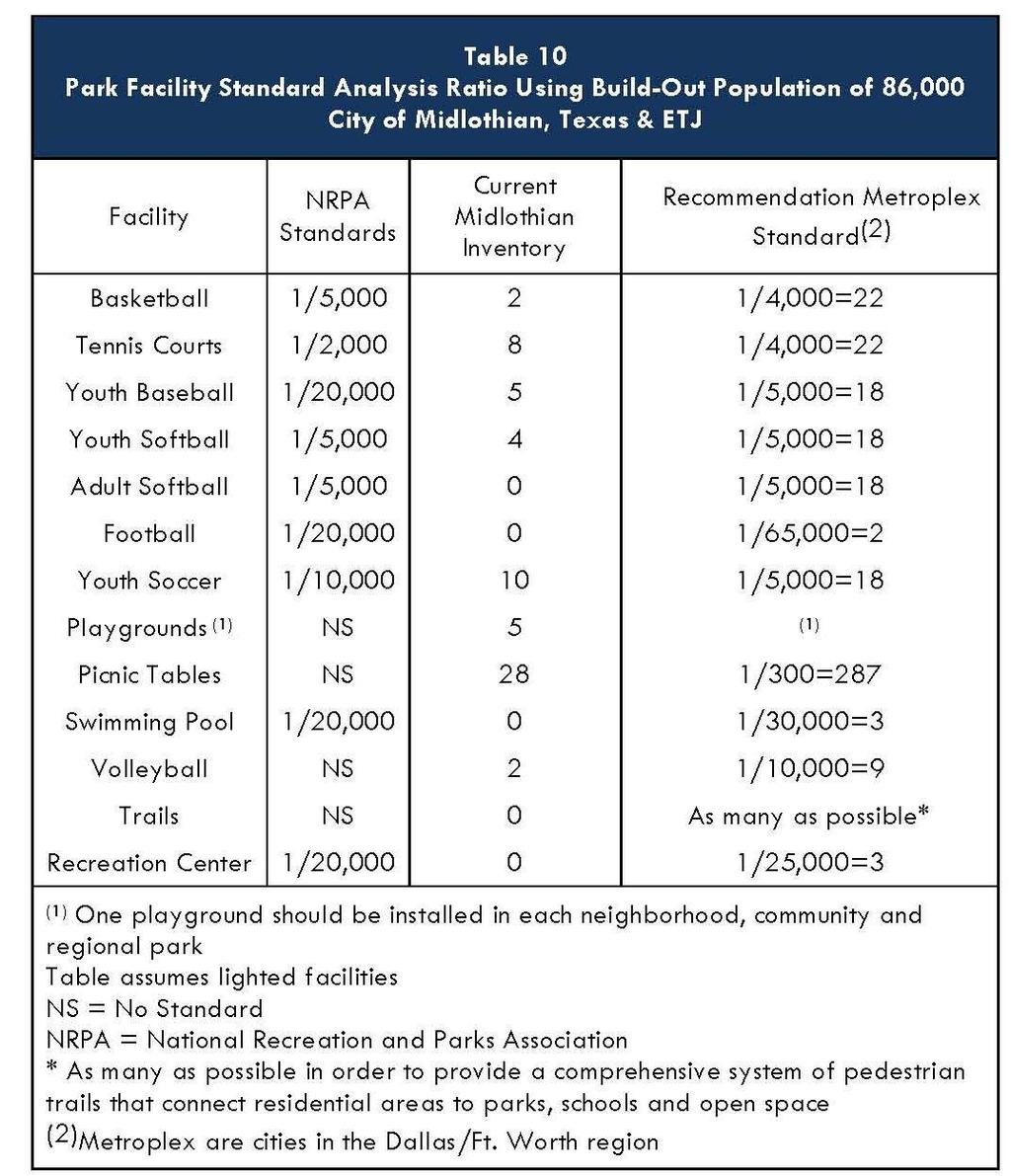
32 The standard analysis has been prepared for the current City population of approximately 18,037within Table 7on the previous page, and for the future projected populations of 33,766 in the year 2020 (Table 8 below), and 60,000 in the year 2025 (Table 9 on the following page). Also shown (in Table 10 on the following page) is an analysis for the projected build-out population of 86,000 for the City and ETJ. This is a standard comparison which illustrates the level of services provided at 18,037 and what the projected facilities need would be for these various anticipated population levels. Again, it is important to note that these are national standards and the comparison will vary from city-tocity. It is common for larger cities to provide recreational facilities for smaller communities nearby. Often, smaller communities do not have recreational facilities and depend on larger area cities for these resources. The Midlothian Parks System provides recreational opportunities for citizens outside the City limits. Page 23

33 Page 24

34 Park Land Analysis Park land analysis is also evaluated on the basis of Midlothian s current population, as shown below in Table 11. This evaluation is a reliable guide and analysis for park land comparison. The acreage required per 1,000 populations varies for each park classification. For long range planning, this is a useful tool for determining future park land acreage acquisition. There is a more detailed discussion addressing park land acquisition in Section V Future Park Improvements and Recommendations. As mentioned previously, the neighborhood park is an important aspect to the overall municipal park system. The ratio of 2.5 acres per 1,000 population should not be confused with the minimum acreage size. The minimum acreage for a neighborhood park should be five (5) acres for several important reasons. A minimum of five (5) acres provides enough land to develop playgrounds, small pavilions, etc. A smaller tract will limit the facilities and the recreational opportunities available to citizens. In the event that a city accepts a smaller tract of land, in the one (1) acre to three (3) acre range, maintenance of these parks would be time consuming and would also require an increase to the City s maintenance budget. A minimum of five (5) acre tracts is therefore recommended for Neighborhood Park development. Page 25

35 DEMAND-BASED ANALYSIS Sports League Association Interviews On April 7, 2011 the following Midlothian leagues were interviewed at the Midlothian City Hall. League presidents, board members or representatives were questioned and explained their league size, membership, league activities and field use. The following was documented. Midlothian Baseball Association In the spring of 2011 the Midlothian Baseball Association had 401 participants, with approximately 13 children per team; the equals to approximately 31 teams. Each team played two (2) games per week. In order to provide each team two games per week the league used the fields on Monday, Tuesday, Thursday, and Friday nights and on Saturday from 9:00 AM until 6:00 PM. The league currently has enough field capacity to accommodate these teams and games. However, using the fields five days a week leaves little room for expansion or growth. The baseball league will need additional fields in the near future. Midlothian Girls Softball Association The Midlothian Girls Softball Association uses the fields at Midlothian Sports Complex. The league has 316 members and 24 teams. In the spring league they use three (3) of the four (4) fields. In the spring the fourth field is used by the Midlothian High School Girls Softball Team for practice and games. The Girls Softball League uses the fields on Monday, Thursday, and Friday. Currently they do not have a need for additional fields. Midlothian Soccer Association The Midlothian Soccer Association uses the soccer fields at Hawkins Spring Park for their league play. The league had approximately 915 members which composed approximately 83 teams. The league played games on Monday, Tuesday, Thursday and Saturday. There are Page 26
36 twelve (12) fields in Hawkins Spring Park that the league uses. At present, twelve (12) fields are adequate to serve their needs. However, there were other issues which effect league play and games. There are traffic and parking concerns at Hawkins Spring Park during league play. The park is crowded and vehicular ingress and egress is a problem. The turf at Hawkins Spring Park is in poor to fair condition due to the shallow top soil, over-use, and lack of irrigation. The Soccer Association has expanded beyond the capacity that Hawkins Spring Soccer Complex can provide. With the 915 participants, traffic issues, and turf condition Hawkins Spring Park cannot provide adequate fields. Midlothian Football Association The Midlothian Football Association has 9 teams with approximately 20 kids per team. The Football Association currently practices at Civic Center Park and plays their homes games at Don Floyd Varsity Field. The Midlothian I.S.D. allows the league to use the field at Don Floyd on a year-by-year basis. The Midlothian I.S.D. has future plans for the stadium and at some point the field will not be available to the Football Association. The league is growing at a rate of ten percent (10%) per year. Once Don Floyd Field is not available to the league they will not have a facility or home field in Midlothian. Midlothian Tennis Association The Midlothian Tennis Association shares the tennis courts at the Midlothian Sports Complex with Midlothian I.S.D. teams. One feature the Association requested was a shaded tennis facility. This would extend the court use during June through August. STATISTICALLY VALID TELEPHONE SURVEY In 2009, the City of Midlothian retained the public opinion research firm Raymond Turco & Associates to conduct a scientifically valid sampling of residents in the community to generate an analysis of their attitudes and how they relate to recreation in the City. The survey was designed to examine residents participation in recreational activities, as well as to assess needs in the community, especially as they relate to Parks and Recreation. The information gathered from this survey allows elected officials and City staff to better understand the recreational needs and desires of the citizenry. The Executive Summary and the Cumulative Results are in the Appendix of this Parks, Recreation & Open Space Master Plan. A complete copy of the full survey results can be found in the Parks and Recreation Department. Page 27
37 FUTURE PARK IMPROVEMENTS & RECOMMENDATIONS

38 V. Future Park Improvements & Recommendations EXISTING PARK IMPROVEMENTS Because of the geographical limits and boundaries of the City, the focus of this section will be the renovation of existing parks. The improvements are based on an analysis of existing facilities. Descriptions of these parks and related recommendations begin below. Civic Center Park Park Size: Park Location: Park Classification: Park Facilities: 6.0 Acres of Developed Park land (Leased Park Property) 224 S. 11 th Street Neighborhood Park Multi-Purpose Fields, Restroom/Concession Stand, 2 Backstops. RECOMMENDED IMPROVEMENTS: No Improvements are planned at this time Page 28


39 Kimmel Park Park Size: Park Location: Park Classification: Park Facilities: 2.9 Acres of Developed Park Land 801 W. Avenue F & N. 2 nd Street Neighborhood Park 6 Picnic Tables, 2 Playgrounds, Restroom, 3 Benches, Gazebo, Drinking Fountain, 85 Parking Spaces plus 4 Handicapped. RECOMMENDED IMPROVEMENTS: Picnic Tables Trail Lighting Irrigation System New Restroom Margie Webb Park Park Size: Park Location: Park Classification: Park Facilities:.25 Acres of Developed Park Land 200 S. 7 th Street & W. Railway Avenue Neighborhood Park 1 Picnic Table, Bench, Pavilion, Playground RECOMMENDED IMPROVEMENTS: Prepare a Master Plan for the park New elements may include: New Covered Playground Fence on North Side of Park Redesign Master Plan Page 29


40 Mountain Peak Community Park Park Size: 10.0 Acres of Developed Park Land Park Location: 6411 Hill Drive and W. FM 875 Park Classification: Park Facilities: Neighborhood Park 2 Playgrounds, Multi-Purpose Court, Pavilion, Restroom Building, Hike & Bike Trail, 9 Picnic Tables, 2 Backstops, Parking Lot. RECOMMENDED IMPROVEMENTS: Covered Playground Additional Tree Planting Ridgeview Park Park Size: Park Location: Park Classification: Park Facilities: 8.6 Acres of Developed Park Land 750 Walter Stephenson Road Neighborhood Park 2 Picnic Tables, Covered Playground, 2 Park Benches, Decomposed Granite Trail, Accent/Seasonal Landscaping. RECOMMENDED IMPROVEMENTS: Seasonal Color Bed/Additional Landscape Parking Lot Page 30

41 Hawkins Spring Park Park Size: 21.7 Acres of Developed Park Land Park Location: 1498 F.M Park Classification: Community Park Park Facilities: 9 Picnic tables, 1 Playground, Benches, Parking Lot, Restrooms/Concession Building, Covered Pavilion, 12 Soccer Fields, Drinking Fountain, Thor Guard Lightning Warning System. RECOMMENDED IMPROVEMENTS: Once the Community Park on Ashford is complete it is recommended to convert the 21.7 acre park to accommodate alternative sports and activities. Prepare a Master Plan for the Park Hike and Bike Trail Large Picnic Pavilion (150 people) BMX Track Skate Board Facility Roller Hockey Spray Park Review Vehicular Ingress/Egress Page 31

42 Jaycee Park Park Size: Park Location: Park Classification: Park Facilities: 10.0 Acres of Developed Park Land 1711 Meadow Lane Community Park 5 Baseball/Softball Fields, Bleachers, 2 Picnic Tables, Drinking Fountain, Playground, Restrooms/Concession Building, Parking Lot, Thor Guard Lightning Warning System. RECOMMENDED IMPROVEMENTS: Once the Community Park on Ashford and 14 th Street is complete it is recommended to convert the 10.0 Acre Park Site to accommodate adult softball. Typical elements would consist of: Possibly Three Adult Softball Fields Hike & Bike Trail Playground Picnic Pavilion Multi-Purpose Court Renovate or Relocate the Restroom/Concession Open Space Page 32

 Back Alley Plaza Park Size: Park Location: Park Classification: Park Facilities: 1.")
43 Midlothian Sports Complex Park Size: Park Location: Park Classification: Park Facilities: 10.6 Acre Sports Park 1000 S. 14 th Street Community Park 4 Softball Fields, 1 Full Basketball Court, Bleachers, Restrooms/Concession Building, 4 Sand Volleyball Courts, 8 Tennis Courts, Thor Guard Lightning Warning System. RECOMMENDED IMPROVEMENTS: Trees and Landscape Beautification Move Fence into 225 Radius on Red, Yellow, and Green Fields (2) Scoreboards Covered Playground Covered Picnic Area Relocate Lights for Girls Softball Concrete Parking Lot/Traffic Control (150 Spaces) Back Alley Plaza Park Size: Park Location: Park Classification: Park Facilities: 1.0 Acre of Developed Park Land 152 Plaza Drive Special Use Park Downtown Plaza Decorative Fence, Parking Lot. RECOMMENDED IMPROVEMENTS: Prepare a Master Plan for the Redevelopment of Back Alley Plaza which may include: Add Gazebo/Performance Stage Structure Water Features Page 33


44 Heritage Park Park Size: Park Location: Park Classification: Park Facilities: 1.0 Acre of Developed Park Land 234 N. 8 th Street Special Use Park Larkin Newton Log Cabin, 1 Picnic Table, Walking Path, Parking Lot. RECOMMENDED IMPROVEMENTS: Add Park Benches Add Picnic Table Mockingbird Nature Park Park Size: Park Location: Park Classification: Park Facilities: Acres 1361 Onward Road and Mockingbird Lane Special Use Hiking/Nature Trail, Butterfly Garden, Bluebird Nest Boxes, Native Grass Area, 2 Benches, Parking Lot. RECOMMENDED IMPROVEMENTS: Trail Education Kiosks Second Pedestrian Entrance Pipe Rail Fence Adjacent to Mockingbird Page 34


45 Triangle Park Park Size: Park Location: Park Classification: Park Facilities:.18 Acres 200 E. Avenue G Special Use Park Sitting Area RECOMMENDED IMPROVEMENTS: Seasonal Color Planting Bed Undeveloped Open Space Park Size: Park Location: Park Classification: Park Facilities: 6.68 Acres Map Reference: Tract A Open Space None RECOMMENDED IMPROVEMENTS: None at this time Page 35


46 Undeveloped Special Use Park Park Size: Park Location: Park Classification: Park Facilities: Acres Map Reference: Tract B Open Space None RECOMMENDED IMPROVEMENTS: None at this time Undeveloped Special Use Park Park Size: Park Location: Park Classification: Park Facilities: 26.0 Acres Map Reference: Tract C Special Use Park None RECOMMENDED IMPROVEMENTS: None at this time Page 36


47 Undeveloped Community Park Park Size: Park Location: Park Classification: Park Facilities: 22.0 Acres Map Reference: Tract D Community Park None RECOMMENDED IMPROVEMENTS: None at this time Undeveloped Special Use Park Park Size: Park Location: Park Classification: Park Facilities: 6.2 Acres Map Reference: Tract E Special Use Park None RECOMMENDED IMPROVEMENTS: Possible Dog Park Site Page 37

48 Future Community Park Park Size: Park Location: Park Classification: Park Facilities: Acres Map Reference: Tract F Community Park None RECOMMENDED IMPROVEMENTS: Hike and Bike Trails Amphitheater Splash Park Basketball Courts Tennis Courts Athletic Fields Fishing Piers Picnic Pavilions Playgrounds Open Space Page 38

49 Future Community Park Park Size: Park Location: Park Classification: Park Facilities: 52.0 Acres Map Reference: Tract G Community Park None RECOMMENDED IMPROVEMENTS: Hike and Bike Trail Nature Trails Camping Opportunities Page 39

50 Undeveloped Community Park Park Size: Park Location: Park Classification: Park Facilities: Acres Map Reference: Tract H Community Park None RECOMMENDED IMPROVEMENTS: None at this time Page 40

51 Undeveloped Open Space Park Size: Park Location: Park Classification: Park Facilities: Acres Map Reference: Tract I Open Space None RECOMMENDED IMPROVEMENTS: None at this time Page 41
52 FUTURE NEIGHBORHOOD PARK ACQUISITION The neighborhood park is considered to be the core unit in a municipal park system because it provides recreation opportunities within walking distance in a neighborhood. The City of Midlothian has a distribution of neighborhood parks and community parks within the City limits. Both park classifications provide recreational opportunities which are typical to neighborhood areas and can serve neighborhood areas. The City is projecting to increase its existing population from 18,037 in 2010 to 33,000 by the year This creates a challenge for Midlothian to provide for adequate park and recreational facilities. The Park and Recreation Department will have to adjust to the growing population as the Midlothian City limits expand by acquiring park land as the City develops; once land is developed for residential and commercial uses, the best opportunity for park land acquisition is lost unless park land is acquired concurrently with the new development. The City will need to acquire approximately acres of neighborhood park land in order to meet the projected 2020 population of 33,000. The future park plan illustrates an additional need of 13 neighborhood parks. It should be noted that the location of neighborhood parks, as illustrated on the Future Park Plan, is general in location and is not intended to identify specific parcels or lots for park land acquisition; the Midlothian Park Department and Planning Department will recommend property acquisition to the Parks and Recreation Board and City Council based on future growth trends and land availability. FUTURE COMMUNITY PARKS, GREENBELTS AND SPECIAL USE PARKS Community Parks Community parks typically provide organized athletic fields and other associated park facilities such as playgrounds, pavilions, splash pads, trails, etc. Currently, Midlothian services citizens outside the City limits and in Ellis County, which creates a need for more park facilities for the City. It should be noted that ETJ residents comprise nearly one-half of all recreational users. In 2006 the City of Midlothian had 60 acres of community park land in the park system. In the last five (5) years the City has acquired an additional acres of community park land. This additional acreage has been classified as community park land although it may also serve as open space. The City should continue this impressive and positive approach to park land acquisition in order to purchase and preserve the land so potential recreational demands for the future can be addressed. Page 42

53 The shortage of park facilities has been amplified through public hearings and sports association interviews. To address this need the City acquired a 104 acre tract and a 52 acre tract of land on the northwest corner of Ashford and future 14 th Street. The proposed recreational elements for the park will be football fields, baseball/softball fields, soccer fields, playgrounds, hike and bike trails, splash pads, tennis courts, basketball courts, amphitheater, water oriented recreational opportunities, and nature and passive interpretive opportunities. Due to limited funding, the park may have to be completed in phases. Although it is anticipated sections of the park may be open by late 2012 to early 2013, a specific time table and date have not been set. Indoor Recreation Centers The City of Midlothian has several needs at this time in terms of its parks system. An indoor recreation center is one of these needs. Typically, cities provide indoor recreational opportunities in the form of a recreation center. These facilities provide for organized work out programs such as aerobic exercise, weight lifting, and stationary low-impact bikes and treadmills. Basketball and racquetball also cultivate recreation opportunities. Typically, recreation centers are approximately 20,000 to 35,000 square feet. These facilities range in cost between $2,000,000 to $14,000,000 dollars. This cost is based on the final square footage and the amenities in the center. The City should plan on construction of this facility within the next five to ten years. Aquatic Facilities Aquatic facilities were mentioned as desired recreational elements during public hearings and telephone surveys. Aquatic facilities can be built as full service aquatic parks, which consist of pools, slides, wading pools and water play features. Initial cost for a facility of this type is estimated at $3,000,000 to $6,000,000. These large multi-million dollar water parks often have a service area larger than the City limits of Midlothian and are typically classified as a regional facility. The City should look at a marketing study or a feasibility analysis while considering an aquatic facility of this scale. Example of Aquatic Facility City of Roanoke, Texas Another feature is a spray park or splash park, which can be built with approximately $200,000 to $500,000. The ultimate size of an aquatic facility is largely dependent on the service area. These types of facilities are often located in community parks. The City should plan to construct an aquatic facility within the next five years. The City is planning a spray park at Kimmel Park and a spray park may be considered at the new community park. Page 43
54 Greenbelts and Open Space In 2006 the City did not have any park land in the Open Space/Greenbelt category. Since 2006 the City has acquired 23 acres of open space. One of the primary uses of greenbelts and open space is for hike and bike trail corridors. Based on the Needs Assessment survey and the Ten-Year Priority List on Page 46, hike and bike trails or multi-use trails has been identified as the number one requested recreational element in Midlothian. The trails were also identified as the number one priority in the 2006 Parks, Recreation and Open Space Master Plan. Although trails are developed in neighborhood and community parks, the most optimal location is in the greenbelts and open spaces of creek corridors. These trails can become destination trails to adjacent cities and internal to Midlothian provide pedestrian trails to retail areas, and to connect parks to other parks and public areas. When property adjacent to creeks and floodplains is developed, floodplain property should be dedicated to the City for Open Space and Greenbelts. The City should accept floodplain areas as a donation and should not purchase the land, unless the City foresees a need for a critical purchase in order to preserve land and/or provide a link to another park. These open spaces preserve trees and native areas and enhance the educational and passive use of floodplains and open space for park patrons. Special Use Parks The City has several special use parks. Back Alley Plaza, Heritage Park, Kimmel Park, Triangle Park and the Mockingbird Nature Center are examples of special use parks. Heritage Park illustrates the historical aspects of Midlothian. The City may acquire/construct additional special use facilities such as a possible tennis center, golf course or aquatic facility. The Mockingbird Nature Park should continue to develop as a preserve and open space. A Master Plan for this park should be considered by the City. Historic Structures The City of Midlothian is fortunate to have several historic structures in the City which provide a look back at the early settlement history of Midlothian. There are at least two (2) structures which could be placed within the Midlothian park system - the Anderson Family Farm structures and the Historic gymnasium at J.R. Irvin Elementary School. The Anderson Family Farm structures consist of the original house built, an original Page 44


55 barn and two sheds. If these structures are to be saved they will have to be relocated to another site. City parks can provide land for this purpose. Once the structures are moved and restored they could provide citizens and tourists a glimpse of life in the early historic settlement of Midlothian. The gymnasium at J.R. Irvin Elementary School could be restored and utilized for a variety of uses. Typical uses for the gymnasium could include indoor recreational activities, youth indoor activities and other community uses such as reunions, conferences, or for instructional or classroom purposes. The gymnasium is currently being used by the Midlothian I.S.D. The rafter support system was designed by German structural engineers and is unique in its form and appearance. A Feasibility Study would have to be performed to insure the structure meets current building codes before any major renovations were undertaken. Page 45
56 TEN YEAR PRIORITY LIST

57 VI. Ten Year City Priority List The Ten-Year Action Plan/Priority List as outlined in Table 12 represents the culmination of the Parks, Recreation & Open Space Master Plan. It is the synoptic conclusion of the park master planning process. Annual review of the action plan by the City Staff, City Council members, Midlothian Parks and Recreation Board members and citizens will allow analysis of action item recommendations for acquisition, improvements and new facilities to enhance the quality of Midlothian Parks and Recreation System to maximum effect. Page 46
58 Plate 2: Future Park Plan Page 47
59 PARK & OPEN SPACE MAINTENANCE STANDARDS
 levels of maintenance.")
60 VII. Park & Open Space Maintenance Standards The purpose of this section is to provide a general analysis of municipal park maintenance. The following park maintenance standards for the Midlothian park system are classified into four (4) levels of maintenance. The levels are designated by Class A, Class B, Class C and Class D, with Class A serving as the highest level of maintenance in terms of man-hours and cost. The following chart is based on the National Recreation and Park Association s maintenance labor standards. Although the classification system provides a realistic guide to park maintenance, it should be noted that the labor equipment and materials needed are general in nature and can be used as a starting point to establish park maintenance budgets. Each park superintendent has a different philosophy and approach to park maintenance and alternative ways to achieve their maintenance goals. These charts and man-hours are only for park maintenance. They do not include hours for preparation of special events, such as parades, concerts, Christmas lighting, etc. The City currently maintains Hawkins Spring Park, Jaycee Park, and the Midlothian Sports Park. The remaining parks are contracted out to private companies. Based on the standards from the National Recreation and Park Association it takes 118 man-hours to maintain one acre of park land. The 118 hours is an average which consists of all types of park land in the City. Therefore, per acre maintenance costs would be 118 acre hours x $12.00 per hour (Midlothian average rate) + 75% for equipment and supplies. The maintenance and operation of park cost in Midlothian would be estimated as $2, per acre. The Maintenance Level Costs chart provides a maintenance level with a percentage factor for equipment and supplies. Appendix C identifies and describes the four levels of park maintenance classifications and the minimum standards for each class. The existing parks in Midlothian are also designated into each maintenance class. As a municipal park system evolves and develops, care and maintenance of the parks, open spaces and recreation equipment must be maintained. The maintenance costs identified above is a simple reminder of on-going employee and budget requirements which must be established. Page 48
City of Fredericksburg, Texas
 City of Fredericksburg Acknowledgements City of Fredericksburg, PARKS, Texas RECREATION & OPEN SPACE Master Plan Prepared by: Dunkin Sims Stoffels, Inc. Landscape Architects / Planners Acknowledgements
PARTF Scoring System for Grants
 PARTF Scoring System for Grants The members of the N.C. Parks and Recreation Authority use the PARTF scoring system as one of several tools to select grant recipients. Please provide all of the information
Town of Northlake. Parks, Recreation and Open Space Master Plan. Prepared By: December 2012 DUNKIN SIMS STOFFELS, INC. LANDSCAPE ARCHITECTS/PLANNERS
 Town of Northlake Parks, Recreation and Open Space Master Plan December 2012 Prepared By: DUNKIN SIMS STOFFELS, INC. LANDSCAPE ARCHITECTS/PLANNERS Mayor Peter Dewing Acknowledgments Town Council Jean Young
City Council March 27, Parks, Recreation, and Trails Master Plan
 City Council March 27, 2018 Parks, Recreation, and Trails Master Plan Planning Process Develop Goals and Objectives Inventory of Areas and Facilities Needs Assessment And Identification Public Participation
1. Parks & Recreation Neighborhood Parks Community Parks Special Use Sites 2. Open Space 3. Trails
 Appendix A: Park Classifications The intent of parks and recreation classifications is to aid in making acquisition and design decisions for park sites, facilities and the organization of recreation space
Parks, and Recreation & Cultural Arts Master Plan Update
 Parks, and Recreation & Cultural Arts Master Plan Update Community Profile Public Input Summary: Staff Interviews conducted April 14 and 15, 2014 Citizens Workshop - conducted April 15 th and 24 th, May
PARKS & RECREATION SUBCOMMITTEE. Oct. 1, 2015
 PARKS & RECREATION SUBCOMMITTEE Oct. 1, 2015 1999 Bond - $22,000,000 Land Acquisition Allen Station Phase II Neighborhood Parks PREVIOUS BOND ELECTIONS 1999 & 2007 2002 Bond - $4,000,000 Allen Senior Recreation
Southeast Quadrant Plan
 Southeast Quadrant Plan Southeast Quadrant Distinctive Features Land Use The Southeast Quadrant includes all the area within the planning area that is east of Interstate 5 and south of State Route 44.
Appendix A. Park Land Definitions
 Appendix A Park Land Definitions Mini Park May serve specific function for any and all ages, depending on need of the user area. Size range 1-5 acres with optimum size being 3 acres. Service area is sub-neighborhood
3. VISION AND GOALS. Vision Statement. Goals, Objectives and Policies
 Vision Statement Queen Creek s interconnected network of parks, trails, open spaces and recreation opportunities provide safe and diverse activities and programs that sustain its unique, small town, equestrian
Executive Summary. Parks and Recreation Plan. Executive Summary
 Parks and Recreation Plan Executive Summary The Whitemarsh Township Parks and Recreation Plan sets forth a vision for how Whitemarsh Township can provide a premiere parks and recreation system reflective
RECREATION AND OPEN SPACE ELEMENT
 RECREATION AND OPEN SPACE ELEMENT Last amended August 19, 2008 Table of Contents Objective Page 5.1 Park system defined... 5-1 5.2 Access to parks and recreational facilities... 5-2 5.3 Recreation and
RECREATION AND OPEN SPACE ELEMENT GOALS, OBJECTIVES, AND POLICIES
 RECREATION AND OPEN SPACE ELEMENT GOALS, OBJECTIVES, AND POLICIES Goal 7 To provide park facilities, recreation programs, and open space resources that are safe, adequate, and accessible to all City residents,
Section 3 INVENTORY OF RECREATION LAND AND FACILITIES
 Photo of Juan Bautista de Anza Park Section 3 INVENTORY OF RECREATION LAND AND FACILITIES Summary of Findings Park Definitions Summary of Recreation Facilities Other Recreation Facilities Nearby Recreation
Northeast Quadrant Plan
 Northeast Quadrant Plan Northeast Quadrant Distinctive Features Land Use The Northeast Quadrant includes all the area within the planning area that is east of Interstate 5 and to the north of State Route
City of Mahtomedi Park System Plan Public Hearing Draft: September 13, 2006
 Chapter 6: IMPLEMENTATION INTRODUCTION Earlier chapters of this Plan analyzed existing conditions, identified park and recreation needs, and proposed park, trail, and open space recommendations. This chapter
TAO S PARKS MASTER PLAN
 TAO S PARKS MASTER PLAN December 2017 Kit Carson Park Fred aca Park Eco Park Youth + Family Center Eco Park TAOS PARKS MASTER PLAN December 2017 SCOPE OF WORK Town of Taos Parks + Recreation Master Plan
PARKS AND RECREATION
 PARKS AND RECREATION The Parks and Recreation Department faces many challenges as the City of Allen continues its rapid growth. Demand for some activities already exceeds the city's ability to provide
Courthouse Planning Area
 Courthouse Planning Area Current Reality The Courthouse Planning Area is the characterized by expansive suburbanscale residential areas as well as the community resource planned area of athletic, educational,
Chapter 6. Overall Vision RECOMMENDATIONS. More Trail and Trail. Connections. Equal Access to Park. Facilities and Programs. Water Access.
 Overall Vision More Trail and Trail Connections Equal Access to Park Facilities and Programs Water Access Environment Variety Chapter 6 RECOMMENDATIONS Chapter 6 The following recommendations for park,
Provide and maintain sufficient public parks, recreation facilities, and open space to meet the recreational needs of County residents and visitors.
 (ROS) Goal Provide and maintain sufficient public parks, recreation facilities, and open space to meet the recreational needs of County residents and visitors. OBJECTIVE ROS.01 The County shall acquire,
City of Naples Parks Master Plan (Draft)
") City of Naples (Draft) CSAB April 12, 2016 OVERVIEW Presentation Outline Overview Needs Assessment Recap Response to Needs Implementation Strategy Questions, Discussion Preserving Naples: A vision plan
City of Naples (Draft) CSAB April 12, 2016 OVERVIEW Presentation Outline Overview Needs Assessment Recap Response to Needs Implementation Strategy Questions, Discussion Preserving Naples: A vision plan
Little Neck Planning Area
 Little Neck Planning Area Current Reality The Little Neck Planning Area is characterized by established residential neighborhoods, Town Center and Pembroke. The Eastern and Western Branches of the Lynnhaven
Focus Groups. 8 Focus Group meetings including 2 with staff, 1 with seniors, and 1 with students
 Project Team Nan Lanahan, Parks & Recreation Jason Gallo, Parks & Recreation Rob Leslie, DEDP John Smolinsky, Planning Board Brent Meredith, Highway Joan Gavrilik, Friends of Parks & Rec MaryLyn Koval,
STAFF RECOMMENDATION: Adopt the Parks and Recreation Master Plan 2013, or take other action as deemed appropriate.
 Regular 7. CITY COUNCIL AGENDA Meeting Date: 12/02/2013 TITLE: Parks and Recreation Master Plan 2013 Adoption Proposal - Dwight Curtis Responsible Staff: Dwight Curtis Backup Material: Backup material
MAYOR. Jim Phaup TOWN COUNCIL
 Acknowledgments MAYOR Jim Phaup TOWN COUNCIL Kara Ranta - Place 1 Saji George - Place 2 Ronnie Henderson, Jr. - Place 3 Jim Wade - Place 4 Karen Hill - Place 5 John Bailey - Place 6 4B DEVELOPMENT CORPORATION
APPENDIX D: PARKS AND RECREATION ACTION PLAN
 APPENDIX D: PARKS AND RECREATION ACTION PLAN Goals The following goals are specific to the development, maintenance, and operation of the existing parks in the Township, as well as the acquisition and
Comprehensive Park System Master Plan
 PARKS AND RECREATION Comprehensive Park System Master Plan Citizen Advisory Committee, June 5, 2012 - Meeting Notes Transcription MIG met with the Parks Citizen Advisory Committee on Tuesday, June 5th,
City of Pigeon Forge
 City of Pigeon Forge Comprehensive Parks and Recreation Master Plan Executive Summary Prepared for the City of Pigeon Forge May 15, 2009 Prepared by: City of Pigeon Forge Comprehensive Parks and Recreation
Outdoor Recreation Facilities Inventory
 Outdoor Recreation Facilities Inventory Allouez Neighborhood Parks: East Lawn Park (4.90 acres) is located in the northeastern corner of Allouez near Boyd Street. This site contains: Baseball diamond with
CHAPPLES PARK MASTER PLAN
 CHAPPLES PARK MASTER PLAN Presentation of Preliminary Development Options Public Open House #2 Wednesday November 2 nd, 2016 TONIGHT S AGENDA 1. Welcome & Introductions 2. Presentation by Sierra Planning
SOUTHEAST SPORTS COMPLEX MASTER PLAN
 REPORT TO SOUTHGATE NEIGHBORHOOD COUNCIL APRIL 13, 2016 Visioning Process April 30: Stakeholder Meeting with Sports Groups May 5: Stakeholder Meeting with Southgate Land Use Committee May 13: SNC Meeting
North Oakville East Parks Facilities Distribution Plan. November, 2009
 North Oakville East November, 2009 POLICY CONTEXT 1) Purpose a) The purpose of this document is to be a guide for the location, configuration, design and development of the parks system for the North Oakville
TABLE OF CONTENTS. Tables Table UC Davis Park and Open Space Resources
 TABLE OF CONTENTS 4.13 Recreation... 4.13-1 4.13.1 Environmental Setting... 4.13-1 4.13.2 Impacts and Mitigation Measures... 4.13-4 4.13.3 References... 4.13-8 Tables Table 4.13-1 UC Davis Park and Open
Comprehensive Parks and Recreation Master Plan. Executive Summary. Submitted To: City of Milton, GA October 2012
 Comprehensive Parks and Recreation Master Plan Executive Summary Submitted To: City of Milton, GA October 2012 Executive Summary The City of Milton envisioned the need for an effective Master Planning
Kempsville Planning Area
 Kempsville Planning Area Current Reality The Kempsville Planning Area is by far the most populated planning area in the City. The preservation of the 1,422 Stumpy Lake Natural Area, the largest City-owned
Request for Statement of Interest in Implementation of the Roosevelt Road Redevelopment Plan
 425 Hillside Avenue Request for Statement of Interest in Implementation of the Roosevelt Road Redevelopment Plan I. INTRODUCTION The is seeking the services of a qualified consulting firm to prepare plans
SECTION 1 Introduction...1. SECTION 2 Regional Context Criteria for Planning Districts Description of Planning District...
 Table of Contents SECTION 1 Introduction...1 SECTION 2 Regional Context...2 2.1 - Criteria for Planning Districts...2 2.2 - Description of Planning District...2 SECTION 3 Goals & Objectives...5 SECTION
3.2 P - Park District
 3.2 P - Intent - The P: s are established to promote and maintain the development of recreational opportunities within the. The development of new parks or the major expansion of existing parks within
APPENDIX C: PUBLIC INPUT SUMMARY
 APPENDIX C: PUBLIC INPUT SUMMARY OVERVIEW The public process for the development of the GO! Green Oshtemo Plan was designed to follow both the legislative requirements for master plan adoption and the
SECTION 4(f) DE MINIMIS DOCUMENTATION
 DE MINIMIS DOCUMENTATION") SECTION 4(f) DE MINIMIS DOCUMENTATION Illinois Route 60/83 IL 176 to the intersection of IL 60 (Townline Road) Lake County P-91-084-07 Mundelein Park and Recreation District Project Limit SECTION 4(f)
SECTION 4(f) DE MINIMIS DOCUMENTATION Illinois Route 60/83 IL 176 to the intersection of IL 60 (Townline Road) Lake County P-91-084-07 Mundelein Park and Recreation District Project Limit SECTION 4(f)
Comprehensive Plan ADOPTED APRIL 2014
 Comprehensive Plan ADOPTED APRIL 2014 8 8. Outstanding Recreational & Cultural Opportunities We are proud of our community s parks and recreation system. Our community will ensure that the legacy of our
Master Plan Presentation August 12, 2015
 Master Plan Presentation August 12, 2015 A vision for tomorrow... May, 13 2015 prepared for: prepared by: SITE LOCATION SITE NTS SITE ANALYSIS +/- 17.8 Ac. RESIDENTIAL HOMES 1 2 RAIL ROAD (SAFETY CONCERNS)
Open Space and Recreational Facilities
 Chapter 5: Open Space and Recreational Facilities A. INTRODUCTION According to the guidelines of the 2001 New York City Environmental Quality Review (CEQR) Technical Manual, an open space analysis is necessary
Mendota Heights 2040 Comprehensive Plan Draft Vers
 4 Parks and Trails The City of Mendota Heights boasts a variety of recreational and open space opportunities. Few cities can claim access to regional trails, riverside and lakeside parks, scenic bluffs
(ALL TIMES LISTED ARE APPROXIMATE AND SUBJECT TO CHANGE. )
") AGENDA TANGENT CITY COUNCIL AND PLANNING COMMISSION JOINT PUBLIC HEARING Wednesday March 16, 2011 PARK COMMISSION SESSION 7:00 p.m.. Bass Estate 32166 Old Oak Drive, Tangent, OR 97389 (ALL TIMES LISTED
AGENDA TANGENT CITY COUNCIL AND PLANNING COMMISSION JOINT PUBLIC HEARING Wednesday March 16, 2011 PARK COMMISSION SESSION 7:00 p.m.. Bass Estate 32166 Old Oak Drive, Tangent, OR 97389 (ALL TIMES LISTED
AVONDALE ESTATES GREENSPACE AD-HOC COMMITTEE
 AVONDALE ESTATES GREENSPACE AD-HOC COMMITTEE INVENTORY AND RECOMMENDATIONS REPORT November 7, 2018 Our Mission Statement: To provide assistance and support, through professional expertise in matters of
6. RECREATION AND OPEN SPACE ELEMENT
 6. RECREATION AND OPEN SPACE Introduction This Recreation and Open Space Element includes Goals, Objectives and Policies (GOP) that apply to the main campus in Gainesville and the Lake Wauburg Recreation
City of Bonney Lake Allan Yorke Park. MASTER PLAN SUMMARY REPORT June 30, 2016
 City of Bonney Lake Allan Yorke Park MASTER PLAN SUMMARY REPORT June 30, 2016 TABLE OF CONTENTS INTRODUCTION PUBLIC INVOLVEMENT PROCESS MASTER PLAN North Park Central Park South Park East Park Field Development
APPENDIX D2: PARKS AND TRAILS
 APPENDIX D2: PARKS AND TRAILS Cultivate Hopkins Comprehensive Plan 8/15/18 DRAFT Cultivate Hopkins Appendix D2 1 Existing Conditions Local Parks and Trails Figure D2.1 shows the existing park and trail
Appendix E Section 4(f) Evaluation
 Evaluation") Appendix E Section 4(f) Evaluation Appendix E Draft Section 4(f) Evaluation E.1 Introduction This appendix addresses a federal regulation known as Section 4(f), which protects parks, recreation areas,
Appendix E Section 4(f) Evaluation Appendix E Draft Section 4(f) Evaluation E.1 Introduction This appendix addresses a federal regulation known as Section 4(f), which protects parks, recreation areas,
PARKS. Chapter Introduction
 Chapter 4. PARKS 4.1. Introduction This Parks Element of the 2016 Comprehensive Plan Update provides direction and guidance, based on citizen input, in order to improve and maintain the City s existing
(Exhibit A) Site Plan Adoption Detail and Support Information
 Site Plan Adoption Detail and Support Information") McCormick Park Master Site Plan (Exhibit A) Site Plan Adoption Detail and Support Information July, 2003 McCormick Park Site Plans.... 2-3 McCormick Park Site Plan Comparison... 4 Basic Assumptions about
McCormick Park Master Site Plan (Exhibit A) Site Plan Adoption Detail and Support Information July, 2003 McCormick Park Site Plans.... 2-3 McCormick Park Site Plan Comparison... 4 Basic Assumptions about
Arlington, Virginia is a worldclass
 EXECUTIVE S U M M A RY Arlington maintains a rich variety of stable neighborhoods, quality schools and enlightened land use policies, and received the Environmental Protection Agency s highest award for
Table of Contents. I. Introduction... P.age 2. II. Goals & Objectives... P.age 6. III. Methodology... P.age 7
 CITY OF TYLER, TEXAS PARKS, RECREATION & OPEN SPACE MASTER PLAN 2010-2020 Table of Contents I. Introduction................................. P.age 2 II. Goals & Objectives........................... P.age
Montana Rail Link Park
 Montana Rail Link Park Neighborhood Open House A Missoula Community Partnership WITH LEADERSHIP FROM THE FRANKLIN TO THE FORT & SOUTHGATE TRIANGLE NEIGHBORHOODS Sovereign Hope Church, (1919 North Ave.)
Port Lavaca Future Land Use
 Port Lavaca Future Land Use Introduction The City of Port Lavaca is beginning to see sustained growth, after many years of relative stable population. New single family homes, apartments, and businesses
Support the implementation of Cape Coral's Comprehensive Plan. Protect and utilize the unique natural resources in the City.
 7.0 OVERVIEW - RECOMMENDATIONS Chapter 7 The preparation of the Cape Coral Parks and Recreation Master Plan spanned a period of approximately 12 months. Plan preparation included the input of a wide range
Cumberland Comprehensive Plan Town Council adopted August 2003, State adopted June 2004 TABLE OF CONTENTS
 TABLE OF CONTENTS I. Executive Summary A. Scope of the Comprehensive Plan I-2 B. Plan Development Process I-3 C. Plan Format I-3 D. Acknowledgements I-4 II. Demographic Analysis A. Introduction II-1 B.
This page intentionally blank.
 This page intentionally blank. Parks, Recreation, and Open Space Chapter Relationship to Vision Vision Parks, Recreation and Open Space Chapter Concepts County Government. County government that is accountable
CHAPTER 9: Parks, Recreation, and Open Space Element
 CHAPTER 9: Parks, Recreation, and Open Space Element INTRODUCTION: The Parks, Recreation, and Open Space Element is a comprehensive representation of the City s vision and goals for the future of the park,
Element 0X Parks, Recreation and Open Space
 Element 0X Parks, Recreation and Open Space Table of Contents 1. Introduction 2. Major Issues, Concerns, and Citizen Input 3. Parks, Recreation and Open Space Goals & Policies 4. Analysis Background and
CHAPPLES PARK MASTER PLAN. Presentation to Council April 10, 2017
 CHAPPLES PARK MASTER PLAN Presentation to Council April 10, 2017 1 PRESENTATION AGENDA 1. Project Background, Aim and Process 2. The Site Issues and Opportunities 3. Community Engagement 4. Vision and
Long Branch-Wayne Local Park Renovation Project
 Montgomery Parks Long Branch-Wayne Local Park Renovation Project Community Meeting #2 September 20, 2016 Oak View Elementary School 7:00-9:00 PM Welcome / Team Introductions M-NCPPC (Montgomery Parks)
PREVIOUS PUBLIC PARTICIPATION BRIEF October 2014
 Comprehensive Planning During the development of the county comprehensive plan, Cultivating Community: A Plan for Union County s Future from 2007 through 2009, and three concurrent multi municipal plans
A BLUEPRINT FOR BROCKTON A CITY-WIDE COMPREHENSIVE PLAN
 A BLUEPRINT FOR BROCKTON A CITY-WIDE COMPREHENSIVE PLAN Public Meeting October 2016 1 Plan Summary and Discussion Public Meeting May 4 2017 City of Brockton Bill Carpenter, Mayor Department of Planning
CITY OF GAINESVILLE PARKS, RECREATION AND CULTURAL AFFAIRS DEPARTMENT VISION 2020
 CITY OF GAINESVILLE PARKS, RECREATION AND CULTURAL AFFAIRS DEPARTMENT VISION 2020 A BLUE PRINT FOR THE NEXT 20 YEARS The PRCA Vision 2020 Master Plan, adopted in November 2012, addresses the current state
I-494 Rehabilitation Project SP (I-394 to Fish Lake Interchange) June 2014 Section 4(f) De Minimis Determination
 June 2014 Section 4(f) De Minimis Determination") I-494 Rehabilitation Project SP 2785-330 (I-394 to Fish Lake Interchange) June 2014 Section 4(f) De Minimis Determination State Project Number 2785-330 Federal Project No. NHPP-I494 (002) Trunk Highway:
I-494 Rehabilitation Project SP 2785-330 (I-394 to Fish Lake Interchange) June 2014 Section 4(f) De Minimis Determination State Project Number 2785-330 Federal Project No. NHPP-I494 (002) Trunk Highway:
The transportation system in a community is an
 7 TRANSPORTATION The transportation system in a community is an important factor contributing to the quality of life of the residents. Without a sound transportation system to bring both goods and patrons
6.0 PARKS AND RECREATION
 6.1 INTRODUCTION offers a combination of regional parklands and Town parks, as well as a range of recreation and leisure programs for its residents. Marin County s extensive open space lands and preserves
M E M O R A N D U M February 21, 2018
 M E M O R A N D U M February 21, 2018 Project: Action Requested: Background Information: CP18-001, Ordinance No. 1060-A, Amendment to the City of Southlake Parks, Recreation & Open Space / Community Facilities
CITY OF COLWICH COMPREHENSIVE PLAN LAND USE LAND USE 1
 LAND USE LAND USE 1 WHAT YOU WILL FIND IN THIS CHAPTER: Discussion of today s conditions and tomorrow s projections Discussion of challenges and opportunities Discussion of the environmental quality goals,
SEWRPC OUTDOOR RECREATION AND OPEN SPACE PLANNING OBJECTIVES, PRINCIPLES, AND STANDARDS
 SEWRPC OUTDOOR RECREATION AND OPEN SPACE PLANNING OBJECTIVES, S, AND STANDARDS Introduction The Southeastern Wisconsin Regional Planning Commission (SEWRPC), as part of the regional park and open space
City of La Center Park, Recreation and Open Space Master Plan. March 2016 Draft
 City of La Center Park, Recreation and Open Space Master Plan March 2016 Draft Table of Contents. Chapter 1: Introduction... 1 1.1 Community Profile... 3 1.2 Master Plan Overview... 3 1.3 Planning Process...
Appendix A Goals and Policies
 Appendix A Goals and Policies i This page left blank intentionally Introduction This Appendix lists the Goals and Policies from the adopted 1996 Parks and Recreation Master Plan. The Parks and Recreation
PARK & RECREATION. Project Summaries
 PARK & RECREATION Project Summaries 45 BEAVER ISLAND TRAIL EXTENSION - PHASE VIII - 60TH ST S TO CITY LIMITS Project Number: PK.19.01 Construction Year: 2019 quality services to area residents who utilize
Special Revenue Funds
 Special Revenue Funds Special Revenue Funds account for the proceeds of specific revenue sources (other than special assessments for major capital projects) that are legally restricted to expenditures
PARKS AND RECREATION
 PARKS AND RECREATION WHAT YOU WILL FIND IN THIS CHAPTER: Background information on the development of the Park, Recreation, and System Plan (PRSP). General overview of Ellensburg s parks and recreation
Town of Peru Comprehensive Plan Executive Summary
 Town of Peru Comprehensive Plan Executive Communities that plan grow by choice, not by chance. A plan makes growth thoughtful, understandable, and predictable. A plan shows that a community is managing
Canal Winchester Parks Master Plan. Public Meeting 2 Thursday, February 2 6:30pm
 Canal Winchester Parks Master Plan Public Meeting 2 Thursday, February 2 6:30pm Meeting Agenda 1. Project overview 2. Project schedule 3. Public input results Survey Public Meeting #1 Stakeholder Interviews
Memo Preliminary. City of Miamisburg Parks Site Reconnaissance
 Memo Preliminary To: From: Ms. Rebecca Benna Woolpert, Inc. Date: Subject: City of Miamisburg Parks Site Reconnaissance The consultant team toured the existing Miamisburg Parks to assess current levels
CECW-AG 11 June 1998 MEMORANDUM FOR MAJOR SUBORDINATE COMMANDS AND DISTRICT COMMANDS
 CECW-AG 11 June 1998 MEMORANDUM FOR MAJOR SUBORDINATE COMMANDS AND DISTRICT COMMANDS SUBJECT: Policy Guidance Letter No. 59, Recreation Development at Ecosystem Restoration Projects 1. References: a. ER
Parks and Open Space Preservation and Dedication. January 26, 2016 Fort Worth City Council Pre-Council Meeting Randle Harwood and Richard Zavala
 Parks and Open Space Preservation and Dedication January 26, 2016 Fort Worth City Council Pre-Council Meeting Randle Harwood and Richard Zavala Purpose How does the City of Fort Worth preserve and protect
The urban parks in Charlottesville include Jackson Park, Lee Park, and McGuffey Park.
 Park Classifications Charlottesville s parks can be grouped into 4 different classifications: urban parks, neighborhood parks, community parks, and regional parks. Figure 1 on page 5 inventories the facilities
Elm Fork Land Use. Trinity River Corridor Project Committee May 13, 2013
 Elm Fork Land Use Trinity River Corridor Project Committee May 13, 2013 Purpose Discuss Trinity River planned Land Use and Appropriate Compatible Uses, particularly with respect to the Elm Fork Area 2
G. RECREATION AND OPEN SPACE ELEMENT. The following summarizes the Recreation and Open Space Element:
 G. RECREATION AND OPEN SPACE ELEMENT The purpose of the Element is to provide the framework and direction for a comprehensive system of public and private sites for recreation, including, but not limited
Rolla Comprehensive Plan Update, 2005 COMMUNITY ISSUES MEMORANDUM 11/1/2004
 COMMUNITY ISSUES MEMORANDUM 11/1/2004 Introduction Throughout the planning process, but particularly during the early phases of the update, various individuals and groups will be asked to identify and
RECREATION AND OPEN SPACE VISION
 City of South Lake Tahoe General Plan Policy Document Recreation and Open Space Element INTRODUCTION This element provides the policy context for the City of South Lake Tahoe to achieve its vision for
SCHOOLS, PARKS AND TRAILS
 Schools, Parks, and Trails Page 1 of 12 SCHOOLS, PARKS AND TRAILS BACKGROUND Public Schools in the Clifton-Fruitvale Community include Clifton Elementary, Rocky Mountain Elementary, Grand Mesa Middle,
Planning Districts INTRODUCTION
 INTRODUCTION To facilitate detailed examination of development prospects for all areas of the community, Delano has been divided into 14 planning districts. The location of these planning districts is
CITY OF SOCORRO, TEXAS REQUEST FOR QUALIFICATIONS FOR PROFESSIONAL LANDSCAPE DESIGN SERVICES FOR PROPOSED MAURO ROSAS PARK
 Trini Lopez Mayor Guillermo Madrid Jr. At Large Maria Reyes District 1 Gloria M. Rodriguez District 2 Mary B. Garcia District 3 / Mayor Pro Tem Jesus Gandara Jr. District 4 Willie Norfleet Jr. City Manager
Section Three Recreation Standards & Needs Assessment
 Section Three Recreation Standards & Needs Assessment William M. Hargraves Center Introduction This section contains the analysis and assessment on which the recommendations of this Comprehensive Parks
Definitions. Average Daily Traffic Demand (ADT): The actual number or projected number of cars that pass a point in a 24-hour period.
: The actual number or projected number of cars that pass a point in a 24-hour period.") Definitions Access Management: A combination of physical techniques and transportation policies used to control the flow of traffic between roads and the surrounding lands. Alternative City Form Scenarios:
Definitions Access Management: A combination of physical techniques and transportation policies used to control the flow of traffic between roads and the surrounding lands. Alternative City Form Scenarios:
SECTION 4 OPEN SPACE ELEMENT
 Open Space Element SECTION 4 OPEN SPACE ELEMENT c 4.1 INTRODUCTION 4.1.1 SCOPE OF ELEMENT The state requires every general plan to have an open space element Section 65302{e». The open space element must
3.1. Introduction. Goals. Purpose
 Thousands of tired, nerve-shaken, over-civilized people are beginning to find out that...parks and reservations are useful not only as fountains of timber and irrigating rivers, but as fountains of life.
General Manager, Planning and Development; General Manager, Parks, Recreation and Culture. Proposed Mini-Park and Plaza Designations
 Corporate NO: R106 Report COUNCIL DATE: June 16, 2008 REGULAR COUNCIL TO: Mayor & Council DATE: June 12, 2008 FROM: SUBJECT: General Manager, Planning and Development; General Manager, Parks, Recreation
PLANNING & DEVELOPMENT BOARD
 PLANNING & DEVELOPMENT BOARD AGENDA The regular meeting of the PLANNING & DEVELOPMENT BOARD will be held at 6:00 p.m. on DECEMBER 19TH, 2017 in COMMON COUNCIL CHAMBERS, City Hall, 108 E. Green Street,
Yadkin River Greenway Feasibility Study Fact Sheet Village of Clemmons, Town of Lewisville, Town of Bermuda Run
 Fact Sheet Village of Clemmons, Town of Lewisville, Town of Bermuda Run Project Background The Yadkin River Greenway Feasibility Study is a joint project with the Village of Clemmons, the Town of Bermuda
ADOPTION OF THE REVISED OPEN SPACE AND CONSERVATION ELEMENT OF THE GENERAL PLAN
 TO: FROM: SUBJECT: Honorable Mayor and City Council Planning Department ADOPTION OF THE REVISED OPEN SPACE AND CONSERVATION ELEMENT OF THE GENERAL PLAN RECOMMENDATION: It is recommended that the City Council:
Errol Heights Park and Community Garden Frequently Asked Questions March 22, 2018
 Errol Heights Park and Community Garden Frequently Asked Questions March 22, 2018 Question 1: What improvements are planned for Errol Heights Park? How will the community be engaged in the process to shape