Broward County Complete Stre ts
|
|
|
- Ashley O’Neal’
- 6 years ago
- Views:
Transcription


1 Broward County Complete Strets Greenways Integration Study PO# SC 033 UP
. 2 Broward County Complete Streets")
2 Prepared by Kimley-Horn and Urban Health Solutions for Broward County Planning and Redevelopment Division Funded by a generous grant from the Florida Department of Economic Opportunity FDEO). 2 Broward County Complete Streets
3 REPORT Table of Contents Executive Summary Introduction Studies, Initiatives, and Facilities Greenways Master Plan Summary Connectivity and Accessibility Municipal Outreach Examples of Common Policies Existing Transportation Conditions Identification of Deficiencies Identification of Strategies and Recommendations. 52 Policy Recommendations and Next Steps References Appendix: Agency/Municipality Contact Sheet; Broward Mobility Projects; Broward 2035 LRTP Cost Feasible Plan CFP) Projects Greenways Integration Study April
4 This page left blank intentionally. 4 Broward County Complete Streets
5 Executive Summary The Broward Metropolitan Planning Organization MPO) endorsed the Complete Streets Guidelines in 2012 to facilitate and assist local governments in the implementation of Complete Streets. The following year the Broward County Commission approved Complete Streets to create a cohesive transportation system that would allow residents to conveniently reach their destinations. Since then, the Broward Complete Streets Team, consisting of two dozen partner organizations participating on the Metropolitan Planning Organization MPO) Technical Advisory Committee TAC), has continued efforts, and several Broward County municipalities have adopted Complete Streets policies moving towards making Complete Streets a reality in their communities. The Broward Complete Streets Team has been working on developing a framework for fully implementing the Complete Streets program. The final review of recommendations was presented to the Broward County Commission in February The Commission approved transmittal of the amendment to the DEO. The ordinance is anticipated to go to the Broward County Commission in June for approval. This is an exciting time for Broward County. Still, the Broward County Greenways Master Plan should be considered when planning for Complete Streets projects. This conceptual plan along with priority corridors were approved by the Broward County Commission in 2002 to improve the quality of life of residents and provide a regional backbone which may further develop or serve as a foundation for the local trail networks. The Broward County Greenways Master Plan depicts 41 proposed corridors covering more than 370 miles of facilities. The proposed corridors consist of a combination of greenways, bikeways, land and water trails, linear parks, on-road bicycle facilities, sidewalks and multi-purpose paths. In addition, the plan includes detailed recommendations for the Barrier Islands Greenway/SR A1A multi-purpose trail. In addition, Broward County is participating in an exciting regional effort being led by the Treasure Coast Regional Planning Council TCRPC) to extend the greenways network and connect Broward s greenways to facilities throughout the Southeast Florida region. In line with Complete Streets, the Broward Greenways Master Plan aims to provide a network of safe alternative modes of transportation, linking neighborhoods to each other and to a variety of points of interest and uses including conservations lands, parks and recreation facilities, cultural and historic sites, schools and business areas. This report aims to identify overlap between Broward County Complete Streets and Greenway Planning initiatives in order to integrate both efforts and work towards a common goal. The report begins by describing ongoing studies, initiatives, and Greenways Master Plan corridor implementation activities. A methodology is developed for identifying connectivity and accessibility opportunities. The study team conducted municipal/agency outreach activities to identify planning and local concerns. Common policies Greenways Integration Study April
6 shared by greenways and Complete Streets were researched and identified that could be capitalized upon for integration. An existing conditions analysis was performed to determine problem areas and identify deficiencies. Finally, the identification of strategies and recommendations developed by the study team to address the problems and deficiencies is presented. Examples of a few of the primary deficiencies that were noted in the analysis are listed below. For the full list of identified deficiencies, please see the section beginning on Page 48 of this report. At locations where greenway trails cross major thoroughfares, direct crossings of the major roadways are not provided. There is a general lack of connectivity between adjacent residential neighborhoods/local streets and greenway trails, especially for greenways trails on canal banks. There is a lack of connectivity to transit facilities from the greenway and complete street network including transfer terminals and mobility hubs. There is often little or no landscaping included in Complete Streets and greenway projects. Public health impact assessments are rarely performed in the transportation facility project development process. A strategies and recommendations summary is listed below. Projects are not yet identified for funding. Potential funding sources could include general roadway funding, future MPO Mobility Projects, and greenways and trails funding such as the Recreational Trails Program. For the full list of strategies and recommendations, please see the section beginning on Page 52 of this report. Improve greenway trail crossings through Complete Street strategies by making it safer for trail users to cross the street. Mid-block crossings with pedestrian refuges, special emphasis markings and signs Use of safety devices such as Rectangular Rapid Flashing Beacons RRFBs) and Pedestrian Hybrid Beacons, a.k.a. High-Intensity Activated Crosswalk HAWK) signals For greenway trails with an elevation difference between the trail and the street, consider creating an underpass for the trail to cross major arterial roadways. Trail underpass and connector path to the cross-street roadway Integrate Complete Street elements and streetscaping to create neighborhood greenways and local and collector streets. Signage Bikes May Use Full Lane [R4-11], Bike Route, Wayfinding) Pavement Markings Shared Lane Markings [Sharrows]) Traffic calming Incorporate sustainable design into roadway design to create green streets. Bioswales, rain gardens, and stormwater reuse Permeable pavement in parking areas or other light traffic areas Create connections between on-street bike facilities and greenway trails. 6 Broward County Complete Streets
7 Ramps can connect on-road bike lanes to adjacent greenway trails As streets are redesigned or resurfaced, incorporate low-speed design principles to help create safe streets for all users. Narrow travel lanes from 12 to 10 or 11 Install curb extensions and follow proper sidewalk zone design principles Create an integrated countywide bicycle route numbering system using standard MUTCD signs to help give people the sense that each bicycle route is part of a larger system. Develop a consistent countywide numbering system that integrates greenways trails and on-road bike lanes that are part of Complete Streets Install M-series and D-series signs from the MUTCD and trail map signs Build priority missing gaps in the greenway network. Examples include the missing New River Trail section between University Drive and Sewell Lock and connecting the Parkland and Coconut Creek greenway sections via Hillsboro Boulevard and U.S. 441 Update the Broward Greenways Master Plan. Promote municipal awareness and integration of the Greenways Master Plan recommendations in future Complete Streets projects. A summary of the Broward MPO Mobility Projects is provided below. Please see Appendix B for a detailed description of the Broward MPO Mobility Projects. Broward MPO Mobility Projects Phase I funded in year 1 TIP according to MPO) LRTP Corridor Project Cost Broward Boulevard Sidewalks $1,663,604 Bike Lanes $6,510,037 US 1 Sidewalks $217,064 Bike Lanes $2,362,326 Hollywood Boulevard Sidewalks $260,200 University Drive Sidewalks $847,302 Oakland Park Boulevard Sidewalks $80,346 Bike Lanes $886,245 Broward MPO Mobility Projects Phase II funded in years 2-4 TIP according to MPO) LRTP Corridor Project Cost Broward Boulevard Sidewalks $968,239 Bike Lanes $26,645,832 Oakland Park Boulevard Bike Lanes $20,093,933 US 1 Bike Lanes $1,614,634 Hollywood Boulevard Bike Lanes $16,821,605 Broward MPO Mobility Projects Phase III funded in year 5 TIP according to MPO) LRTP Corridor Project Cost US 1 Sidewalks $510,795 Bike Lanes $13,257,376 Hollywood Boulevard Sidewalks $1,377,328 Bike Lanes $10,994,880 Greenways Integration Study April
8 Introduction The following report is intended to inform the client of all relevant matters pertaining to past, present and future activities in Broward County, Florida, regarding Complete Streets and greenways corridor planning, and identify improvement and policy strategies for integrating greenways corridor planning with Complete Streets. Methodology The project researcher took an exploratory approach which involved investigating all public domains including municipal websites, periodicals and official documents. To have access to the most recent information about Complete Streets and greenways in Broward, the investigator called and ed the appropriate municipal departments and divisions responsible for such projects. Most often, the departments consulted for this study were Planning and Zoning, Public Works, Engineering, and Community Development. The data gathering of facts and resources occurred between November 6 and December 8, Report Sections 1. Studies, Initiatives, and Facilities Identify and summarize ongoing studies and initiatives throughout Broward County, including municipal level activities, regarding Complete Streets initiatives and greenways corridor planning. Identify existing and planned bicycle and pedestrian facilities. 2. Greenways Master Plan Summary Review and summarize the corridors, analysis, vision, policies and action items from the Broward County Greenways Master Plan. 3. Connectivity and Accessibility Develop methodology and identify standards for connectivity and accessibility between the existing and proposed greenways and identified and proposed Complete Streets corridors and networks. 4. Municipal Outreach Contact municipalities to identify planning and local concerns. 5. Common Policies Determine common policies shared by greenways and Complete Streets that could be capitalized upon for integration. 6. Existing Transportation Conditions Analyze transit, bicycle, and pedestrian conditions to determine problem areas. 7. Identification of Deficiencies Identify deficiencies based on performance measures and standards. 8. Identification of Strategies and Recommendations Select strategies that address the deficiencies identified in the previous analysis. 9. Policy Recommendations and Next Steps Identify policies and techniques that will assist addressing safety concerns. 8 Broward County Complete Streets
9 Studies, Initiatives, and Facilities Identify and summarize ongoing studies and initiatives throughout Broward County, including municipal level activities, regarding Complete Streets initiatives and greenways corridor planning. Identify existing and planned bicycle and pedestrian facilities. Broward MPO endorsed the Complete Streets Guidelines on July 12, 2012, to facilitate and assist local governments in the implementation of Complete Streets. On March 12, 2013, the Broward County Commission unanimously approved Complete Streets to create a cohesive transportation system that would allow residents to conveniently reach their destination. Subsequently, the Broward County Complete Streets Team was formed to propose the appropriate framework for fully implementing the program, such as land development codes, roadway standards, transportation policies, outreach and funding strategies. Since March, the Broward Complete Streets Team has been working on reviewing and recommending revisions to the County on roadway construction minimum standards, County Land Development Code Criteria, Broward County Trafficways Plan criteria, and the Broward County Land Use Plan and County Comprehensive Plan, including intergovernmental coordination. These revisions are currently undergoing final review. The Complete Streets Team has also been working on soliciting, compiling, and analyzing short-term "Complete Streets" criteria, implementation, and long-term "Land Use/Transportation" program. In addition, the Complete Streets Team established an outreach program to maintain coordination with federal, regional, municipal, and other interested stakeholders. Furthermore, the Complete Streets Team aims to identify available and potential sources) of funding county/state/federal/partnerships, etc.) both to construct demonstration/pilot Complete Streets projects and to sustain long-term implementation of revised "Complete Streets" criteria. The Complete Streets Team has developed a list of "recent and funded" Complete Streets projects and is working collaboratively with the Office of Management and Budget to investigate development of a FY 14/15 funding plan to fund identified/ preferred Complete Streets pilot projects and develop a countywide "Complete Streets" program. Two demonstration projects have been identified to illustrate principles and measure the benefits of a Complete Street. A Complete Street in a suburban area may look different than a Complete Street in the urban core, but both are designed with the same principles. Taking this into account, the two demonstration projects selected for analysis are: Urban setting at Hollywood Blvd. 26th Ave to Dixie Hwy Suburban setting at Sunset Strip NW 72nd Ave to NW 19th St Both corridors accommodate all modes of transportation. The Complete Streets Team is currently working on final revisions to the Broward Comprehensive Plan to incorporate Complete Streets Greenways Integration Study April
10 standards. The final review of recommendations was presented to the Broward County Commission in February The Commission approved transmittal of the amendment to the DEO. The ordinance is anticipated to go to the Broward County Commission in June for approval. Proposed Broward Complete Street County initiatives include: Wide sidewalks Shaded pathways with trees Midblock crossings Flashing illuminated pedestrian signs Reduced speed limits Reducing lane widths where appropriate down from 11 to 10. Adding buffered bike lanes along county roadways to promote bicycle safety. Green bike lanes establishing a bicycle symbol with a green background throughout the county for bicyclists to show the emphasis on bicycle lanes). Creation of parklet trade spaces for outdoor activities such as dining. Municipalities across Broward County are joining with Complete Streets by adopting Complete Street Guidelines and creating Complete Streets projects within their own communities. Many others are studying ways to take part. The investigation identified several communities that are undergoing Complete Streets initiatives and or greenways corridor planning: Deerfield Beach, Fort Lauderdale, Hollywood, Pembroke Pines, Hallandale Beach, Tamarac, North Lauderdale, Davie, Coconut Creek, Cooper City and Weston. Deerfield Beach Adopted Complete Street guidelines. A Complete Streets Plan is being created, which will identify target areas that could be improved with elements, such as crosswalk improvements, bicycle facilities and trees along the streets for extra shade. Staff then will be able to apply design elements from the Complete Streets Guidelines to street projects at locations identified in the Complete Streets Plan. Fort Lauderdale Adopted Complete Streets Manual Perimeter Road along the Fort Lauderdale-Hollywood International Airport is listed in the pipeline for future Complete Streets development. Perimeter Road is located west of the Broward Greenways Master Plan proposed priority corridor of Dixie Highway/FEC Trail; south of the proposed New River Loop 27 mile water trail); and north of the proposed priority corridor of Griffin/Orange Dr. Greenway 13.6 mile multi-purpose path along C-11 Canal). A Complete Streets/Greenway mobility project has been proposed for SW 4th Avenue between SR 84 and the New River. The SW 4th Avenue greenway will connect to the proposed New River/SR 84 Greenway identified in the Broward Greenways Master Plan. 10 Broward County Complete Streets
11 The Florida Department of Transportation working in conjunction with the City of Fort Lauderdale implemented buffered bike lanes on SR A1A between Oakland Park Boulevard and Flamingo Avenue in Fort Lauderdale as part of its A1A Greenway project. The five foot bike lanes are separated from motor vehicle lanes with a two to five foot buffer. This project is in line with recommendations from the Broward Greenways Master Plan Barrier Islands Greenway/SR A1A Trail priority phase one corridor. Hollywood Adopted Complete Streets Policy. Hollywood and the Broward MPO are working on the Hollywood/Pines Boulevard Congestion Management Process/Livability Planning Project that has three high priority Complete Streets projects: Hollywood Boulevard City Hall to Dixie Highway): MPO officials recently awarded Hollywood more than $5 million for a "Complete Streets Project" that targets Hollywood Boulevard from Dixie Highway to City Hall. Improvements may include narrower travel lanes, wider sidewalks, bike lanes, improved pedestrian crossings, bus shelters, and landscaped medians. This project connects to the Broward Greenways Master Plan priority phase one corridor of Dixie Highway/FEC Trail. Johnson Street C 10 Canal to US 1): The City and MPO have a proposed Complete Streets project on Johnson Street set to include on-street bike lanes and connected, wider sidewalks. The C-10 Canal Trail is a proposed 3.2 mile multi-purpose path in the Broward Greenways Master Plan. Dixie Highway/21st Avenue Pembroke Road to Sheridan Street): The Dixie Highway/FEC Trail is a proposed Broward Greenways Master Plan phase one priority corridor proposed to be implemented as part of an integrated Complete Streets project along Dixie and 21st Avenue. Other key recommendations include: Johnson Street bike lanes Flamingo Road to C 10 Canal): Flamingo Road is a proposed priority phase one multi-purpose path in the Broward Greenways Master Plan. Extend SR 820 TSM&O/ATMS System to Dykes Road: The SR 820 Pines Blvd. right-of-way R.O.W.) is the location of the Broward Greenways Master Plan proposed Pembroke Pines/Hollywood Trail. Pedestrian Safety Improvements Turnpike to SR 7): The Pembroke Pines/Hollywood Trail is a proposed greenway along Hollywood/Pines Boulevard in the Broward Greenways Master Plan. Pembroke Pines Adopted resolution supporting Smart Growth Principles in October Smart Growth partnerships recently awarded the city a grant, and a project is set to begin in January A landscape architect is working on a greenway nature corridor. The Pembroke Pines/Hollywood trail located on Pines Blvd R.O.W. was proposed in the Broward Greenways Master Plan as a multi-purpose path with bike lanes and sidewalks. Greenways Integration Study April
12 Hallandale Beach The City of Hallandale Beach has embraced Complete Streets, is working with the MPO, and is preparing a Complete Streets Plan with a consultant. The goal is to survey all infrastructure. Tamarac and North Lauderdale Davie Broward County recently completed the Bailey Road Complete Streets Project, which incorporates wide sidewalks with shaded pathways and buffered bike lanes. Also the speed limit was lowered to 35 miles per hour. Bailey Road is located south of the Broward County Greenways Master Plan proposed phase one corridors of North Lauderdale South Trail 2.8 mile multi-purpose path north of McNab) and the proposed priority one C-14 Canal/Cypress Creek Greenway 12.9 mile multipurpose path). Bailey Road also connects to the proposed Rock Island Road Florida Power and Light FPL) R.O.W Trail 11.1 mile multi-purpose trail parallel to and one mile west of State Road 7). A corridor study is underway along NW 57th Street in the City of Tamarac to develop a mixed-used district as part of the city s efforts to encourage green development initiatives. The Davie Road extension will have buffered bike lanes with a pullout area for buses. A continuous sidewalk will be enhanced with illuminated crosswalks to promote pedestrian safety. In the future, additional streets may have refuge areas where pedestrians can safely stop if caught in between traffic signals. Davie Road is located in the City of Davie and connects to the north with the Broward Greenways Master Plan proposed priority corridor of New River/SR 84 Greenway 11.7 mile multipurpose path along the SR 84/New River R.O.W.). A number of other projects are planned throughout the year. To the south, Davie Road connects to the proposed priority corridor of Griffin- Orange Dr. Greenway 13.6 mile multi-purpose path along C-11 Canal). Coconut Creek The Coconut Creek City Commission adopted a Resolution supporting Complete Streets and has implemented Complete Street concepts on Coconut Creek Parkway and as part of the City s Main Street Project Area downtown plan). Staff is currently evaluating transit supportive land use categories to coincide with Complete Streets. Staff will be amending the Comprehensive Plan and Land Development Code in February 2014 to incorporate Complete Streets guidelines. 12 Broward County Complete Streets
13 The Broward County Greenways Master Plan proposed facilities including multi-purpose paths, bike lanes and sidewalks. The plan also proposed the Creek/Springs FPL R.O.W. multi-purpose path that traverses Coconut Creek. In addition, Coconut Creek is bordered to the north by the proposed Hillsboro Canal Greenway 12.7 mile multi-purpose path and bordered to the east by the proposed Turnpike Greenway 12.1 mile water trail. Coconut Creek has implemented several sections of municipal greenways including the Long Pine Greenway west of Lyons Road and the Hilton Road Greenway, which connects to residential areas west of the end of Hilton Road. Cooper City Complete Streets supporting policies: the Cooper City Code of Ordinances requires the construction of sidewalks along both sides of every roadway within the City limits. All new development is required to construct sidewalks in the development consistent with the City s engineering standards. Policy requires the Growth Management Department to continue implementing land development regulations requiring sidewalks for new development and redevelopment. The City s land development regulations also require that nonresidential developments provide on-site bicycle racks. Policy provides for additional appropriate bicycle parking. Cooper City is located near two of the Broward Greenways Master Plan proposed priority greenway corridors: south of the Griffin-Orange Dr. Greenway/C-11 Canal and east of the Flamingo Road Trail. In addition, Cooper City is located north of the Greenways Master plan proposed corridors of the Rock Creek FPL R.O.W, West Trail FPL R.O.W and Central Trail R.O.W as well as south of the proposed corridor of Nob Hill Trail. Weston The League of American Bicyclists recently designated the City a Bicycle Friendly Community in part due to its Bicycle Master Plan which indicates that bike lanes are currently provided on over 90 percent of all arterial roadways within the City. The Bicycle Master Plan also outlines future strategies to continue providing multi-modal transportation facilities. The City of Weston lies between two Broward Greenways Master Plan priority phase one corridors: Conservation Levee multi-purpose path to the north and west and Griffin-Orange Dr. Greenway multi-purpose path to the south. Pompano Beach The City of Pompano Beach has achieved a context-sensitive corridor designation from the Broward County Planning Council for Martin Luther King, Jr. Boulevard from I-95 to Dixie Highway to pave the way for implementing complete streets solutions on this Trafficways Plan corridor. Greenways Integration Study April
14 Other County Initiatives Related to Complete Streets and Greenways Greenway Pedestrian Crossings The FDOT District Traffic Operations Office is putting together a task force to address issues on greenway pedestrian crossings and has committed to work with Broward County on this issue. Broward B-Cycle The Broward B-Cycle, Broward County s newest mode of public transportation and the first countywide bike-sharing system, is expanding and will complement Complete Streets initiatives in Broward County. A new station has been added at the southwest corner of Las Olas Boulevard and Southeast Eighth Avenue in the City of Fort Lauderdale. Broward B-Cycle currently maintains 275 bikes available for sharing at its 27 station locations in Broward County. The stations are located in the following six cities: Fort Lauderdale, Hollywood, Pompano Beach, Dania Beach, Hallandale Beach and Lauderdale-By-The-Sea. Commitment Long Range Transportation Plan Commitment Long Range Transportation Plan LRTP) is currently in the public outreach process to gather the communities priorities for transportation in the County. Public workshops have been held to identify community goals and objectives, and 29 MPO Board members have been interviewed. Over 1,100 surveys have been collected, which provided more than 800 open-ended comments. Feedback has been sought from all 31 municipalities to identify community needs and priorities, and plans have been collected from service providers, including FDOT, BCT, and SFRTA. Of public comments received, the majority 73%) specifically mentioned transit. This priority also was reflected in Board member interviews, during which roadway improvements and Complete Streets were mentioned as well. Express bus service, commuter rail and light rail also were mentioned. Another survey is now available at to help refine options regarding transit, bicycling, and walking. Community meetings will continue in order to generate as many responses as possible and stimulate public involvement. The Broward County Transit Development Plan The Transit Development Plan serves as the strategic guide for public transportation in Broward County over the next 10 years. Development of this TDP included a number of activities, including documentation and analysis of the demographic conditions in BCT s service area, an evaluation of existing transit services in Broward County, market research and extensive public involvement efforts, an analysis of immediate and longer term transit service and capital project needs, and a funding analysis and plan which initiate strategic approaches to maintaining and expanding transit services in Broward County within the next 10 years and beyond. The TDP is also known as BCT Connected because its main theme is connectivity, which includes links to other modes of transportation such as bicycle and pedestrian networks. 14 Broward County Complete Streets
15 Greenways Master Plan Summary Review and summarize the corridors, analysis, vision, policies, and action items from the Broward County Greenways Master Plan. Introduction The Broward County Greenways Master Plan was developed to improve the quality of life of residents in urban environments and create a countywide system of greenways and trails. Broward Greenway corridors consist of a combination of linear parks, on-road bicycle facilities, sidewalks and multi-purpose paths. Vision The vision of the Broward County Greenways Master Plan is to have a fully-funded countywide network of bicycle and equestrian paths, nature trails and waterways that are safe and clean. The countywide greenway system will connect each neighborhood, from the Everglades to the Atlantic Ocean, to conservations lands, parks and recreation facilities, cultural and historic sites, schools, and business areas. The greenway system would provide opportunities for recreation, restoration and enhancement of native vegetation and wildlife habitat, as well as alternative modes of transportation. Summary The Broward County Greenways Master Plan contains over 370 miles of regional greenways, bikeways, land trails and water trails delineated on the conceptual master plan. The countywide network of greenways depicted provides a regional backbone which may further develop or serve as a foundation for the local trail networks, such as the trails of Davie, Plantation, Parkland and Southwest Ranches. The plan also serves as a framework for individual municipalities to link together their local planning efforts. In total, 41 proposed corridors are recognized in the Broward County Greenways Master Plan. In addition, select priority phase one corridors were identified during the planning process, public input and subsequent planning meetings see figure on the following page). Furthermore, the following phase one corridors were selected as having the highest priority for development: Dixie Highway/Florida East Coast Railroad Trail; Cypress Creek/C-41 Canal; Conservation Levee; New River/SR 84 Greenway; Flamingo Road Trail/Hiatus Road C-42 Canal Trail; Barrier Islands Greenway SR A1A Trail; and Griffin- Orange Dr. Greenway/C-11 Canal. These corridors effectively form a framework that traverses all parts of the County, and provide a good representation of differing types of trails, from wide paved and unpaved trails through natural and rural areas, to wide sidewalks through urban areas, providing opportunities for all types of Greenway users and interests. Greenways Integration Study April

16 Broward Greenways Master Plan Note: The Broward County Greenways Master Plan map was produced in 2002 and therefore does not include The Wedge, which has since been added as part of Broward County via agreement with Palm Beach County. 16 Broward County Complete Streets


17 All maps and figures in the Greenways Master Plan Summary section of this report are: Source: Broward County Greenways Master Plan Greenways Integration Study April
18 Action Items Recommended action Items for the Broward County Greenways Master Plan included: Adopt the Broward County Greenways Master Plan Continue the Mission of the County s Greenways Establish Greenway Funding Sources Establish an Implementation Schedule Promote Greenway and Trails within Broward County Construct Greenway Corridors Broward County Greenways Master Plan Implementation The Broward County Board of Commissioners approved the Greenways Master Plan In February of 2002 along with individual plans and funding strategies for the design and construction of select phase one corridors. The Board of Commissioners also established a Selection/Negotiation committee to hire a firm to design and permit four of the selected priority corridors. In November of 2002, the Broward County Board of Commissioners approved a $2.4 million dollar contract for the survey, design, and permitting for the following phase one corridors: C-14 Canal 10.6 miles) - Cypress Creek Greenway 12.9 miles) Dixie Highway/Florida East Coast Railroad Trail 28.6 miles) New River/SR 84 Greenway 11.7 miles) Flamingo Road Trail 10.9 miles) - Hiatus Road C-42 Canal Trail 5.3 miles) Also included in this contract was the Master Plan for the Barrier Islands Greenway/SR A1A Trail 25.7 miles). During 2003, additional field visits and tours of the priority corridors along with public workshops and permitting agency meetings helped verify and finalize the greenway routes within the selected priority corridors. Summary of Broward Greenways Master Plan Priority Corridors The following section provides a summary of the phase one priority corridor individual plans included in the Broward Greenways Master Plan. Proposed development activities include pedestrian and bicycle friendly features such as paved trails, pedestrian bridges, narrowing of roads, widening of sidewalks, landscaping, signs, bike racks, air stations, drinking fountains and benches. 18 Broward County Complete Streets
19 C-14 Canal/Cypress Creek Greenway The C-14 Canal-Cypress Creek Greenway comprises over 23 miles of trail, connecting the beach to the Everglades. The trail would originate south of Atlantic Boulevard at a trailhead adjacent to the proposed Conservation Levee Trail. A pedestrian/bicycle overpass is proposed at this location to provide a crossing over the Sawgrass Expressway and the greenway to the east. This trail includes a main segment which follows the C-14 Canal, a portion which follows the meandering Cypress Creek, as well as shorter spurs through Margate and Coral Springs Riverside Canal) and North Lauderdale. Upon completion, the trail will connect the natural conservation areas of western Broward County to the eastern beachfront area, and the numerous communities between. The City of Tamarac completed construction of a portion of this greenway within their jurisdiction in This section runs from University Drive west to the end of Southgate Blvd., along a 2.5 mile path. Veterans Park, located at the northwest corner of Southgate Blvd. and University Dr. has a bike path, picnic area with grill, small boat launching ramp, a Veterans Memorial, restrooms and parking. Communities: Tamarac, Coral Springs, Coconut Creek, North Lauderdale, Margate and Pompano Beach. New River/SR 84 Greenway The New River Greenway will extend over 11 miles through central Broward County from the Everglades to Port Everglades. This corridor is the location of one of Broward County's oldest bicycle and pedestrian paths. Enhancements and upgrades to the path, including better separation from the busy I-595 corridor, would provide a bicycle and pedestrian friendly corridor linking Markham Park and Broward's western conservation area to Port Everglades. The greenway would also reestablish bicycle and pedestrian links to the College/University complex in Davie which were lost when I-595 was constructed. This greenway would utilize wide sidewalks, bicycle and pedestrian paths, as well as a bridge suspended from the SR 7 overpass to maximize connectivity. In 2002, Broward County worked on the design and construction of a multi-purpose path along two sections of this corridor. The Marina Mile project, located on the north side of SR 84 from I-95 to the New River drawbridge, is an eight to 10 foot-wide paved multi-purpose path that was renovated by the Florida Department of Transportation to include a six foot-wide path on the north side. West of Greenways Integration Study April

20 the New River drawbridge, Broward County completed design of the "Missing Link" project to include a 10 foot-wide multi-purpose landscaped path beginning just east of SR 7 and ending at the Sewell Lock. This project includes a bridge over the New River Canal east of SR 7. The project was named Missing Link because it would restore bicycle/pedestrian connections along SR 84 to west Broward County lost when I-595 was constructed. Communities: Sunrise, Plantation, Davie and Fort Lauderdale. Dixie Highway/Florida East Coast Railroad Trail The Dixie Highway Greenway consists of more than 28 miles of multi-purpose path, bike lanes, and sidewalks, creating a trail that connects the historic main streets and downtowns of Broward's eastern cities. The proposed trail originates at Pioneer Park near the Deerfield Beach City Hall complex and travels south through Deerfield Beach, Pompano Beach, Oakland Park, Wilton Manors, Fort Lauderdale, Dania Beach, Hollywood and Hallandale Beach. Potentially, the trail could link to Greynolds Park in Miami-Dade. Several submittals were made to the Florida East Coast Railway FEC) in 2003 illustrating the Dixie Highway Greenway Route, including sections showing development of the FEC right-of-way R.O.W.) within FEC guidelines. The FEC replied to the request, denying the use of the R.O.W. at the time. Subsequently, the design team worked on identifying potential alternatives and held two public workshops in 2004 to gather input for the revised Dixie Highway Greenway design. Communities: Deerfield Beach, Pompano Beach, Oakland Park, Wilton Manors, Fort Lauderdale, Dania Beach, Hollywood and Hallandale Beach. 20 Broward County Complete Streets

21 Flamingo Road Hiatus Road C-42 Canal Greenways The Flamingo Road Greenway comprises nearly 11 miles of trail running from Plantation to Miramar along Flamingo Road. The Hiatus Road Greenway comprises more than five miles of trail which run along the C- 43 canal from Sunrise to Plantation. Together this corridor connects Broward s western communities from the central County to the Miami- Dade County line. The Flamingo Road and Hiatus Road Greenways pass through a variety of land uses, including suburban and rural areas. This corridor provides a unique opportunity in urban Broward County for development of a rural and semi-rural multi-purpose trail serving equestrians, bicyclists and hikers. In addition, the trail ends in Miramar adjacent to the Snake Creek Canal where opportunities exist for future connection to Miami-Dade County greenways. Communities: Sunrise, Plantation, Davie, Southwest Ranches, Pembroke Pines, and Miramar. Barrier Islands Greenway/SR A1A Trail The Barrier Islands Greenway is over 25 miles in length. The purpose of this greenway is to establish one of the most desirable recreation corridors in the County. Continuous multi-purpose paths along the beach, the A1A roadway itself and various neighborhood streets will link public beaches, resorts, waterside communities, activity centers, marinas, restaurants, municipal centers and other attractions. This corridor requires roadway reconstruction of A1A due to lack of sidewalks and bike lanes. The corridor plan proposes a bicycle facilities network to link to other neighborhoods through the addition of bike lanes, multi-purpose paths, wide sidewalks and bicycle-friendly bridges over the Intracoastal. In addition, the plan proposes an extended broadwalk to Dania Beach to create a continuous beach-side route. Through the use of appropriate signs and other markers, the Barrier Islands Greenway has the potential to become the premier attraction in South Florida further enhancing the unique sense of place along the corridor, as well as being an asset to each local neighborhood. Communities: Deerfield Beach, Hillsboro Beach, Lighthouse Point, Pompano Beach, Sea Ranch Lakes, Lauderdale-by-the-Sea, Fort Lauderdale, Dania Beach, Hollywood and Hallandale Beach. Greenways Integration Study April
 south along the western edge of the County and the Everglades.")
22 Conservation Levee The Conservation Levee covers over 48 miles of western Broward County. The greenway would extend from the Palm Beach County line and the Loxahatchee National Wildlife Refuge to the north) south along the western edge of the County and the Everglades. This greenway would intersect with several Broward Greenways Master Plan proposed corridors including C-14 Canal-Cypress Creek Greenway, New River/SR 84 Greenway, Hiatus Road C-42 Canal Trail, Griffin-Orange Dr. Greenway, Pembroke Pines/Hollywood Trail and C-9 Canal Trail. Conservation Levee would continue south with potential future connections to Miami-Dade County. Broward County earmarked $200,000 from the Safe Parks and Land Preservation Bond program in 2002 to design and construct trail heads and access points for the Conservation Levee Trail at Markham Park and Atlantic Blvd. The Parks and Recreation Division also began the design process at Markham Park. Plans were submitted to the South Florida Water Management District SFWMD) for access at Atlantic Blvd. and the Sawgrass Expressway in The construction planned improvements included parking, which required the County to petition the District to waive its prohibition of parking on its right-of-way. Communities: Parkland, Coral Springs, Tamarac, Sunrise, Weston, Southwest Ranches, Pembroke Pines and Miramar. 22 Broward County Complete Streets

23 Municipalities included in the Broward Greenways Master Plan In addition to the individual phase one priority corridor plans provided in the conceptual Broward Greenways Master Plan, a snapshot of proposed corridors in each of the following Municipalities is also included in the plan: Coconut Creek Priority trail passing through municipality: C-14 Canal-Cypress Creek Greenway Priority trail near municipality: Cypress Creek Future trails passing through or adjacent to municipality: Hillsboro Canal Greenway; Creek/ Springs FPL R.O.W. Trail; Coconut Creek Trails; and Turnpike Greenway Future trail near municipality: Rock Island Road FPL R.O.W. Cooper City Priority trails passing through municipality: Flamingo Road Trail and Griffin-Orange Dr. Greenway Future trails passing through or adjacent to municipality: Nob Hill Trail; Griffin-Orange Dr. Greenway; West Trail FPL R.O.W.; Central Trail FPL R.O.W.; Rock Creek FPL R.O.W. Coral Springs Priority trails passing through municipality: C-14 Canal-Cypress Creek Greenway; Riverside Dr. Canal Trail; N. Lauderdale South Trail; and Conservation Levee. Future trails passing through or adjacent to municipality: Creek/Springs FPL R.O.W. Trail and Rock Island Road FPL R.O.W. Future trails near municipality: Parkland Trail and Parkland Trails Dania Beach Priority trail passing through municipality: New River Greenway Priority trails near municipality: Dixie Highway Greenway and Barrier Islands Greenway Future trails passing through or adjacent to municipality: Intracoastal Waterway; New River Loop; Griffin-Orange Dr. Greenway; Central Trail FPL R.O.W.; C-10 Canal Greenway; The CSX Greenway Future Trail near municipality: New River Greenway Greenways Integration Study April
24 Davie Priority trails passing through municipality: New River Greenway; Hiatus Road Greenway; Flamingo Road Greenway; and Griffin-Orange Dr. Greenway. Priority trail near municipality: Conservation Levee Future trails passing through or adjacent to municipality: Intracoastal Waterway; C-12 Canal Trail; 5th Ave. Trail; New River Loop; Nob Hill Trail; Griffin-Orange Dr. Greenway; West Trail FPL R.O.W.; Central Trail FPL R.O.W.; C-10 Canal Trail; and The CSX Trail. Deerfield Beach Priority trails passing through municipality: Dixie Highway FEC Trail and Barrier Islands Trail Future trails passing through or adjacent to municipality: Hillsboro Canal Greenway; Turnpike Greenway; and Intracoastal Waterway Future trails near municipality: Creek/Springs FPL R.O.W. and Central Trail FPL R.O.W. Fort Lauderdale Priority trails passing through municipality: Cypress Creek Greenway; Dixie Highway Greenway; and Barrier Islands Greenway Future trails passing through or adjacent to municipality: Cypress Creek; Turnpike Greenway; Intracoastal Waterway; Middle River Trail; C-12 Canal Trail; and New River Loop. Hallandale Beach Priority trails passing through municipality: Dixie Highway/FEC Trail and Barrier Islands Trail Future trails near municipality: Intracoastal Waterway; The CSX Greenway; and Pembroke Pines/ Hollywood Trail. Hillsboro Beach Priority trails passing through or near municipality: C-14 Canal-Cypress Creek Greenway; Dixie Highway/FEC Trail; and Barrier Islands Greenway. Future trails near municipality: Hillsboro Canal Greenway; Pompano Air Park; NE 15 Ave/SE 2 Ave Trail; NE 26 Ave Trail; and Intracoastal Waterway. Hollywood Priority trails passing through or adjacent to Municipality: New River Greenway; Dixie Highway Greenway; Intracoastal Waterway; and Barrier Islands Greenway. Future trails in or near municipality: New River Loop; Griffin-Orange Dr. Greenway; West Trail FPL R.O.W.; Central Trail FPL R.O.W.; The CSZ Trail; Pembroke Pines/Hollywood Trail; and Miramar Parkway Trail. Lauderdale-By-The-Sea Priority Trails passing through or adjacent to Municipality: Intracoastal Waterway and Barrier Islands Trail. Future trails near municipality: Snook Creek; NE 26th Ave. Trail; and Middle River Trail 24 Broward County Complete Streets
25 Lauderhill Future trails passing through or near municipality: Rock Island Road FPL R.O.W. Trail; Turnpike Greenway; C-13 Canal Trail; Sunrise/Plantation Trail; C-12 Canal Trail; and 5th Ave Trail. Margate Priority trails passing through municipality: C-14 Canal-Cypress Creek Greenway and Riverside Dr. Canal Trail. Priority trail near municipality: N. Lauderdale South Trail Future trails passing through or near municipality: Creek/Springs FPL R.O.W. Trail; Rock Island Road FPL R.O.W.; and Turnpike Greenway Miramar Priority trail passing through municipality: Flamingo Road Trail Priority trail adjacent to municipality: Conservation Levee Future trails passing through or near municipality: Central Trail FPL R.O.W.; C-9 Canal Trail; Pembroke Pines/ Hollywood Trail; 172nd Ave Trail; and Miramar Parkway Trail. Parkland Priority trail adjacent to municipality: Conservation Levee Future trails passing in or near municipality: Hillsboro Canal Greenway; Parkland Trail; Creek/ Springs FPL R.O.W. Trail; Rock Island Road FPL R.O.W.; and Parkland Trails. Plantation Priority trails passing through or adjacent to municipality: New River Greenway; Hiatus Road Greenway; and Flamingo Road Greenway. Priority trail near municipality: Conservation Levee Future trails passing through municipality: C-13 Canal Trail; Sunrise/Plantation Trail; C-12 Canal Trail; 5th Ave. Trail; New River Loop; and Nob Hill Trail. Sunrise Priority trails passing through or near municipality: New River Greenway; Hiatus Road Greenway; Flamingo Road Greenway; and Conservation Levee. Future trails passing through municipality: C-13 Canal Trail; Sunrise/Plantation Trail; C-12 Canal Trail; 5th Ave. Trail; and Nob Hill Trail. Tamarac Priority trails adjacent to municipality: C-14 Canal- Cypress Creek Greenway; Riverside Dr. Canal Trail; N. Lauderdale South Trail; and Conservation Levee. Future trails passing through municipality: Cypress Creek; Rock Island Road FPL R.O.W.; Turnpike Greenway; C-13 Canal Trail; and Middle River Trail. Weston Priority trail passing through municipality: Conservation Levee; New River/SR 84 Greenway; and Griffin-Orange Dr. Greenway Future trail near municipality: 172nd Ave Trail Greenways Integration Study April


26 Connectivity and Accessibility Develop methodology and identify standards for connectivity and accessibility between the existing and proposed greenways and identified and proposed Complete Streets corridors and networks. Goal The following goal is proposed for connectivity and accessibility between existing/proposed greenways and identified/proposed Complete Streets corridors and networks. Integrate Broward County s existing/proposed greenways network into a comprehensive network of Complete Streets to encourage connectivity to the greenways by sustainable modes of transportation. The Complete Streets connectivity to greenways may include a Countywide network of on-street bicycle facilities, shared use paths, crossing improvements where greenways cross major thoroughfares, landscaped boulevards, green streets, and linear parks, which link the County s neighborhoods to one another and to the major parks and public transportation hubs. Source: Kimley-Horn Source: Kimley-Horn Greenways should include connectivity for crossing roadway thoroughfares. Safe and frequent crossing facilities are a hallmark of Complete Streets as well. 26 Broward County Complete Streets
27 Methodology Accomplish the integration of the existing/proposed greenways network into a comprehensive network of Complete Streets through the following methodology steps. Identify streets and roads that connect to existing/proposed greenways. Identify streets and roads that provide access to trailheads that serve the existing/proposed greenways. Identify crossing deficiencies for existing greenway trails where engineering improvements could be implemented to improve safety and mobility along the greenway. Develop recommended strategies for enhancing the connectivity between the streets/roads and greenways and improving crossing opportunities for greenway trail users at major thoroughfares. Identify policies and techniques that will assist in addressing safety concerns. Prioritize strategies by an evaluated order of importance. Standards The following standards were developed to provide guidance for the implementation of the methodology identified above. The integrated network will primarily serve as sustainable transportation infrastructure walking, bicycling, and public transportation). Direct connections will be provided between the greenway network and the transit network through Complete Street strategies. Connectivity strategies will take advantage of recent engineering techniques and innovative ideas for improving connectivity and safety. Street users must be able to access the greenway system from cross-streets. Greenway trail users should be able to cross major thoroughfares safely and efficiently without significant deviation from the path. Intersections between greenway trails and cross-streets should be treated as public street right-of-way intersections. Connections will support the physical health and well-being of residents. Connections will promote social inclusion and sociability. Car-free living will be supported by improving connections to Countywide destinations by sustainable transportation modes. Street trees and landscaping will be integrated to enhance shade and improve the aesthetic quality. Greenways Integration Study April
28 Municipal Outreach Contact municipalities to identify planning and local concerns. The investigators attempted to contact each Broward County municipality to identify planning and local concerns. Although the investigators were able to obtain valuable feedback from several of the municipalities, further follow up is required to obtain more information. Please see the Appendix p. 68) for a contact sheet. In addition to individually contacting municipalities, the investigators conducted a literature review of news articles and county meeting minutes to acquire additional information about planning and local concerns. Recent Broward news articles and surveys have indicated that Broward County residents would walk and bike more if the appropriate infrastructure were in place. This evidence breeds hope that the adopted Broward Complete Streets Guidelines will pave the way for safer and healthier streets across the county. Concerns for pedestrian and bicycle infrastructure also have been voiced at Broward Metropolitan Planning Organization MPO) Technical Coordinating Committee TCC) meetings, where city officials gather from County municipalities. At the August 28, 2013 Broward MPO TCC meeting, there was discussion about public desire for better bicycle and pedestrian connections, real-time passenger information, increased service and frequency, and increased service awareness. Other concerns are fatalities related to jaywalking and crosswalk issues. During a recent Broward MPO Technical Coordinating Committee Meeting, Jeff Weidner FDOT) expressed concern with regard to accidents involving individuals who cross mid-block when trying to catch a bus. One source of concern is Oakland Park Boulevard/SR 7, which has on-street transfer points for transit. At this location, riders often run from the eastbound stop to the next bus. At the January 23, 2013 Broward MPO TCC meeting, Sheila Rose Coconut Creek) expressed concern about the arterial bike lanes in Broward County, stating that if these lanes are not buffered from vehicular traffic, particularly in high-speed corridors, they are almost a waste of funds. Gary Rogers City of Lauderdale Lakes) cited a crosswalk issue on the C -13 canal trail a Broward Greenways Master Plan proposed 8.1-mile multi-purpose trail), which was completed on the east and west ends of SR 7. Gary Rogers reported that jaywalking is out of control in this location and along a similar canal in Margate, and he said attention should be directed toward the Evidence indicates residents would walk and bike more if the appropriate infrastructure were in place. issue. He also noted that there are plans to add more canal trails in the future, which could exacerbate the problem even further. Jeff Weidner reiterated that the first step will be to make pedestrians aware there is a problem, then to follow up with enforcement so individuals will understand why they are being ticketed. Eric Swanson, Regional Planner/Policy Analyst with the South Florida Regional Planning Council, has been working with several Broward County municipalities, including Coconut Creek, Wilton Manors, Hollywood, Pembroke Pines and Hallandale Beach, and has found that there is a perceived disconnect on how the cities can partner with the County to implement pilot projects for Complete Streets. It is recommended that the County work on devising methods and criteria for the County s cities to follow when seeking to implement a Complete Street project. 28 Broward County Complete Streets

29 Examples of Common Policies Determine examples of common policies shared by greenways and Complete Streets that could be capitalized upon for integration. The Broward County Greenways Master Plan is a conceptual plan that serves as a framework of a potential countywide system of corridors consisting of a combination of linear parks, on-road bicycle facilities, sidewalks and multi-purpose paths. In line with Complete Streets, the Broward Greenways Master Plan aims to provide a connected network of safe alternative modes of transportation linking neighborhoods to each other and to various points of interest and land uses including conservation lands, parks and recreation facilities, cultural and historic sites, schools, and business areas. The Greenways Master Plan includes 41 proposed corridors with survey and design plans for select priority phase one greenways that include pedestrian and bicycle friendly facilities such as paved trails, pedestrian bridges, landscaping, paving, bike racks, air stations, drinking fountains and benches. In addition, the plan proposes the narrowing of certain streets as well as widening of paths. A more detailed design outline was created for the Barrier Islands Greenway/SR A1A Trail. This proposed greenway spans 25 miles in the communities of Deerfield Beach, Hillsboro Beach, Lighthouse Point, Pompano Beach, Sea Ranch Lakes, Lauderdale-by-the-Sea, Fort Lauderdale, Dania Beach, Hollywood and Hallandale Beach. The Barrier Islands Greenway/SR A1A Trail improvements detailed in the Master Plan are listed below by community. Deerfield Beach: 1. A1A Roadway Reconstruction - Roadway requires reconstruction due to lack of sidewalks and bike lanes. New section to include wide sidewalks and bike lanes. 2. Local Links / Bicycle Facilities Network - Link to other neighborhoods through the addition of bike lanes and wide sidewalks. East Hillsboro bridge over the Intracoastal should include bicycle-friendly bridge grates. Source: Broward County Greenways Master Plan 3. Beach-side Facilities at Deerfield Beach - Add wayfinding and informational signs to existing pedestrian-friendly facilities which include multi-purpose paths, sidewalks and/or bike lanes. 4. A1A Roadway with Existing Paths - Roadway segment along SE 20th Ave. has a path and bike lanes. It may be possible to widen the path in the future. Greenways Integration Study April

 The segment along Hillsboro Mile is the narrowest segment throughout the corridor.")
30 Deerfield Beach is proud to be the first city in Broward County to adopt Complete Streets Guidelines and lead the way in creating a healthier community by making their streets complete. A Complete Streets Plan is being created, which will outline target areas within the City that could be improved with crosswalk improvements, bicycle facilities, and trees along the streets for extra shade. Staff will then be able to apply the design elements within the Complete Streets Guidelines to street projects at locations identified in the Complete Streets Plan. Hillsboro Beach and Lighthouse Point A1A Roadway 40 right-of-way) The segment along Hillsboro Mile is the narrowest segment throughout the corridor. Roadway reconstruction will be required to create the Greenway and improve pedestrian/bicycle through this corridor. Artist's concept of the 40' right-of-way configuration Source: Broward County Greenways Master Plan Pompano Beach 1. A1A Roadway Restriping - Restripe road along North Ocean Blvd. near Hillsboro Inlet and Lighthouse Point to include bike lanes. Sidewalks are already present. Right-of-way widths limit the ability to construct paths without major roadway and right-of-way reconfiguration). Source: Broward County Greenways Master Plan 2. Local Links / Bicycle Facilities Network - Link to other neighborhoods through the addition of bike lanes and wide sidewalks. Bridges over the Intracoastal along NE 14th St. and E. Atlantic Blvd. should include bicycle-friendly bridge grates. 3. A1A Roadway with Existing Bike Lanes and Sidewalks - Segment along North Ocean Blvd. already includes bike lanes and sidewalks. However, this roadway segment is very wide and would be a good candidate for future roadway narrowing to create a future multi-purpose path. 4. Beach-side Facilities at Pompano Beach - Add wayfinding and informational signs to existing pedestrian-friendly facilities which include multi-purpose paths, sidewalks and/or bike lanes. 30 Broward County Complete Streets


31 Sea Ranch Lakes A1A Roadway with Existing Bike Lanes and Sidewalks - Segment already includes bike lanes and sidewalks. However, this roadway segment is very wide and would be a good candidate for future roadway narrowing to create a future multi-purpose path. Lauderdale-By-The-Sea 1. Two Local Links / Bicycle Facilities Network - Link to other neighborhoods through the addition of bike lanes and wide sidewalks. Commercial Blvd. bridge over the Intracoastal should include bicycle-friendly bridge grates. 2. A1A Roadway Restriping - Restripe road to include bike lanes. Sidewalks already present. Right of way widths limit ability to construct paths without major roadway and right of way reconfiguration). Source: Broward County Greenways Master Plan 3. A1A Roadway with Existing Bike Lanes and Sidewalks - Segment along South Ocean Blvd. already includes bike lanes and sidewalks. However, this roadway segment is very wide and would be a good candidate for future roadway narrowing to create a future multi-purpose path. 4. Lauderdale by the Sea - Connect Greenway facilities to the City s proposed multi-purpose path. 5. A1A Roadway Reconstruction - Roadway near Codrington Dr. requires reconstruction due to lack of sidewalks and bike lanes. New section to include wide sidewalks and bike lanes. Fort Lauderdale 1. A1A Roadway Reconstruction - Roadway near NE 42nd Ct. requires reconstruction due to lack of sidewalks and bike lanes. New section to include wide sidewalks and bike lanes. Source: Broward County Greenways Master Plan 2. Connect to Galt Ocean Mile Corridor - Shift Greenway to parallel corridor which includes existing sidewalks and bike lanes. 3. Alternate Local Links - Until improvements are made on A1A including intersection improvements, utilize local streets such as North Ocean Blvd. and Galt Ocean Drive. Some minor improvements must be made, including restoration of sidewalks in these locations as well as the addition of directional signs. Greenways Integration Study April

32 4. Local Links / Bicycle Facilities Network - Link to other neighborhoods through the addition of bike lanes and wide sidewalks. Commercial Blvd., Sunrise Blvd. and Las Olas Blvd. bridges over the Intracoastal should include bicyclefriendly bridge grates. 5. North Fort Lauderdale Beach Blvd. A1A Roadway Section through Ft. Lauderdale Beach - Reconfigure to create a wide path along the beach side of roadway, as well as sidewalks and bike lanes. 6. Beach-side Facilities - Add Artist's concept of the 70' right-of-way configuration for North Ft. Lauderdale Beach Blvd. A1A Roadway through Ft. Lauderdale Beach. Source: Broward County Greenways Master Plan wayfinding and informational signs along A1A to existing pedestrian-friendly facilities which include multi-purpose paths, sidewalks and/or bike lanes. See illustration.) 7. A1A Roadway Reconstruction - Roadway along Sea Breeze Blvd. requires reconstruction due to lack of sidewalks and bike lanes. New section to include wide sidewalks and bike lanes. A recent article from the Sun Sentinel states that the Florida Department of Transportation plans to put in buffered bike lanes on State Road A1A between Oakland Park Boulevard and Flamingo Avenue in Fort Lauderdale as part of its A1A Greenway project. The 4-foot bike lanes will be separated from vehicle lanes with a 2-foot buffer. 8. Alternate Local Links - Until improvements are made on A1A including intersection improvements, local streets such as South Ocean Drive should be utilized. Some minor improvements must be made, including restoration of sidewalks in these locations as well as the addition of directional signs. 9. Beach-side Path - Design and construct a beach-side path or boardwalk along what is one of the widest beaches in Broward. Path would go along South Beach Park and terminate at the inlet th Street Bridge Improvements - Includes existing bike lanes and observation deck. Create an opening in the barrier to allow for safe bicycle access to observation decks. Reconstruct bridge surface with bikefriendly road grates. 11. A1A Roadway Restriping - Restripe 17th Street to include bike lanes. Sidewalks are already present. Right-of-way widths limit ability to construct paths without major roadway and right-of-way reconfiguration.) 32 Broward County Complete Streets


33 Dania Beach Local Links - Construct sidewalks, bike lanes and multi-purpose paths along A1A east on NE 2nd St 14 past Frost Park to Gulfstream Rd. then south to East Dania Beach Blvd. then east to Dania Beach Pier. Source: Broward County Greenways Master Plan Hollywood 1. A1A Roadway with Existing Bike Lanes and Sidewalks - Segment along South Ocean Drive already includes bike lanes and sidewalks. However, this roadway segment is very wide and would be a good candidate for future roadway narrowing to create a multi-purpose path. 2. Beach-side Path - Extend the Broadwalk to Dania Beach Pier to create a continuous beach-side route. Source: Broward County Greenways Master Plan 3. Local Links / Bicycle Facilities Network - Link to other neighborhoods through the addition of bike lanes and wide sidewalks. Sheridan St. and Hollywood Blvd. bridges over the Intracoastal should include bicycle-friendly bridge grates. Recently, MPO officials awarded Hollywood more than $5 million for a "Complete Streets Project" that targets Hollywood Boulevard from Dixie Highway to City Hall. Improvements may include narrower travel lanes, wider sidewalks, buffered bike lanes, pedestrian lighting, improved pedestrian crossings, bus shelters and landscaped medians. Although this project would complement the proposed priority corridor of Dixie Highway/FEC trail, these Complete Streets efforts could be extended along Hollywood Blvd. to link with SR A1A. 4. Beach-side Facilities Ocean Walk - Add wayfinding and informational signs to existing pedestrian-friendly facilities which include multi-purpose paths, sidewalks and/or bike lanes. 1. Local Links / Bicycle Facilities Network - Link to other neighborhoods through the addition Hallandale Beach of bike lanes and wide sidewalks. Hallandale Beach Blvd. bridges over the Intracoastal should include bicycle-friendly bridge grates. 2. A1A Roadway with Existing Bike Lanes and Sidewalks - Segment along South Ocean Drive already includes bike lanes and sidewalks. However, this roadway segment is very wide and would be a good candidate for future roadway narrowing to create a multi-purpose path. Greenways Integration Study April

34 Existing Transportation Conditions Analyze transit, bicycle, and pedestrian conditions to determine problem areas. A general transportation mobility analysis was conducted to identify transit, bicycle, and pedestrian mobility issues through data analysis using Broward County data and planned projects. The analysis was based on existing conditions, data collected for this Study, and approved plans and programs from transportation agencies. The purpose of this task is to collect data that will allow the study team to properly assess the deficiencies of non-motorized travel modes in Broward County, and to analyze the current and future greenways and Complete Streets integration needs. Transit Analysis Existing Conditions Fixed route public transportation is provided by Broward County Transit BCT), municipalities through the Community Bus program, and the South Florida Regional Transportation Authority SFRTA), which operates the Tri-Rail commuter rail system. BCT s fixed route system comprises 95 percent of the BCT family of services ridership and provides connections to Broward s multimodal transportation network as well as system wide connections at four transfer terminals. The fixed route system comprises 35 bus routes operating seven days per week. The typical daily service span for most routes is from approximately 5:00 AM through approximately 11:00 PM. Service frequencies vary widely depending on route ridership and service needs, but generally range from 15 minute headways on busier routes during peak periods to 60 minute headways on weekends and lower volume routes. All BCT fixed route buses are wheelchair accessible and equipped with bike racks. On board a Broward County Transit BCT) bus Source: Broward County Transit 34 Broward County Complete Streets


35 BCT also operates limited stop Breeze service for three of its busiest routes. The Breeze service has limited stops along the route at major intersections only, typically spaced approximately every 1-2 miles, on weekdays during morning and afternoon peak hours. The Breeze routes are listed below. 441 Breeze University Breeze U.S. 1 Breeze In addition, BCT operates express bus service between free commuter park-and -ride locations to Miami-Dade County and downtown Fort Lauderdale. The express bus routes operate the majority of their trip length on interstate highways. 595 Express Bus Service provides service along I-595 and I-95 linking Sunrise and Weston to Miami and downtown Fort Lauderdale. 95 Express Bus Source: Broward County Transit 95 Express Bus Service operates from Pembroke Pines, Hollywood, and Miramar to Miami utilizing 95 Express lanes on I-95. It should also be noted that Miami-Dade Transit MDT) operates 95 Express Bus routes that originate in Broward County and serve destinations in Miami. MDT 95 Express Bus routes operate from the Broward Boulevard/I-95 park-and-ride lot and the Sheridan Street/I-95 park-and-ride lot. The four BCT transfer terminals are listed below where numerous fixed routes intersect. Broward Central Terminal Lauderhill Mall Transfer Facility Plantation West Regional Terminal Pompano Northeast Transit Center Additional BCT services include the following. Paratransit Transportation Options, or TOPS) Community Bus program Emergency Services Of particular interest to this Study is the Community Bus program, which supplements BCT s fixed route service with additional fixed route service designed to increase the number of BCT bus stop with bench, trash receptacle, and newspaper racks Source: Kimley-Horn Greenways Integration Study April

 municipalities.")
36 Source: Kimley-Horn destinations within municipalities that residents can access through public transit and serve local trip patterns. Community buses typically serve residential areas and allow larger BCT buses to travel along major thoroughfares as part of the regional network. The Community Bus program routes connect to nearby BCT fixed routes and are wheelchair accessible and equipped with bike racks. Currently BCT s Community Bus program operates in partnership with eighteen 18) municipalities. BCT bus stop without sidewalk connection or passenger waiting infrastructure Many BCT bus stops are Americans with Disabilities Act ADA) accessible. However, some bus stops lack sidewalk connectivity and proper surface areas. Benches and shelters are provided at bus stops with higher boarding activity, although many bus stops lack these features. Typically it is the responsibility of the local municipality to provide shelters and benches at bus stops. Few bus stops include bicycle parking racks as part of the design, although new and reconstructed bus stops are being designed with bike racks. Commuter rail service is provided by the South Florida Regional Transportation Authority SFRTA) through Tri-Rail operating along the South Florida Rail Corridor SFRC) primarily adjacent to I-95. Tri-Rail provides north-south service between Miami International Airport MIA) and Mangonia Park north of West Palm Beach). The 71-mile long Tri-Rail system has eighteen 18) stations, including seven 7) stations in Broward. Tri-Rail connects directly to Amtrak at several stations including Hollywood, Fort Lauderdale, and Deerfield Beach. Tri-Rail also connects to the MDT Metrorail Green Line at the Metrorail Transfer Station and in the future will connect to the Metrorail Source: Kimley-Horn Tri-Rail bicycle parking locker Orange Line at the Miami Central Station at Miami International Airport. Free Tri-Rail shuttle buses are offered at twelve 12) Tri-Rail stations to connect passengers to the surrounding community. Operating within an active freight corridor, many Tri-Rail stations are located in industrial areas making the shuttle buses and connections to county fixed route bus systems crucial. Bicycles are allowed on Tri-Rail trains. Tri-Rail riders can also utilize complimentary bike lockers at most train stations. Access to lockers is provided with a refundable deposit of $20. The bike lockers allow secure bicycle parking to a greater degree than conventional bicycle parking racks, which are also 36 Broward County Complete Streets

37 available at most stations. The bike locker program integrates bicycle travel with Tri-Rail commuting allowing a truly green experience and extending the range of travel to and from Tri-Rail stations. Some Tri-Rail commuters keep bikes on both the origin and destination sides of their typical daily commute by utilizing the bike locker program. SFRTA offers approximately 600 bike lockers for bicycle and accessory storage. Future Conditions The Transit Development Plan TDP) is a useful guide to ensure that the current transit system is operational for the 10-year TDP timeframe and also to outline how transit services can improve over the ten year period. The plans is also necessary to receive funding from FDOT. The plan serves as the strategic guide for public transportation in Broward County over the next 10 years. Development of this TDP included a number of activities, including documentation and analysis of the Broward TDP Status Quo Plan Source: Broward County Transit demographic conditions in BCT s service area, an evaluation of existing transit services in Broward County, market research and extensive public involvement efforts, an analysis of immediate and longer term transit service and capital project needs, and a funding analysis and plan which initiate strategic approaches to maintaining and expanding transit services in Broward County within the next 10 years and beyond. The TDP is also known as BCT Connected because its main theme is connectivity, including links to other modes of transportation such as bicycle and pedestrian networks. The BCT TDP includes a Status Quo Plan and a Vision Plan. The Status Quo Plan ensures the maintenance of the current system, replacement of vehicles at the end of their useful span, and the Greenways Integration Study April

38 Broward TDP Vision Plan Source: Broward County Transit implementation of programmed improvements. The Status Quo improvements are shown below. The Vision Plan is intended to enhance the BCT transit system beyond its current capabilities, level of service, and current funding levels. The Broward MPO 2035 Long Range Transportation Plan LRTP) is the currently adopted plan to identify transportation projects and priorities with funding that is anticipated to be available through The Plan identifies a future transit network and mobility hubs in its Cost Feasible Plan CFP). A map of the 2035 LRTP Cost Feasible Plan CFP) transit and mobility hub projects is included in the Appendix. The Broward MPO is currently preparing the 2040 LRTP. SFRTA also is in the midst of planning for expanded future services. SFRTA is working with its partner agencies to create a truly regional transit system. To meet future travel demand, SFRTA is strategically planning for several needed transit projects to provide for the future regional mobility needs of South Florida s residents and visitors. These projects will allow people to rely on transit and enjoy the benefits of avoiding increasingly congested highways, while saving money on gas and automobile maintenance costs. These projects complement existing and planned transit service by SFRTA s transportation partners, and will provide the backbone of an expanded regional transportation system that may include light rail, busways, streetcars, and rapid bus transit. The current planned projects include the following. Regional Transit Oriented Development TOD) Program SFRTA has initiated an outreach program to assist local communities with maximizing their transit station areas development potential, in ways that are consistent with their community vision. TOD is typified by an urban design that 38 Broward County Complete Streets

39 creates pedestrian friendliness by careful placement of buildings, parking areas, and roadway features. In addition, TOD is characterized by a mix of uses that ideally creates 18 hours of activity. Southeast Florida has already begun to reinvest attention and funds into downtowns and urban cores. In addition, the market acceptance of urban downtown living, the rehabilitation of older urban neighborhoods, and the growing intolerance for traffic congestion and long commutes have all had a tremendous impact. The Wave Streetcar in Downtown Fort Lauderdale The Wave is an environmentally friendly streetcar system planned for downtown Fort Lauderdale. The project seeks to create a livable community by integrating land use, transportation and economic development while being environmentally sustainable. The project is funded through a variety of local, state, and federal funding sources attained by the project partners. The Wave is a 2.7 mile modern streetcar circulator system extending from the Broward General Hospital/17th Street in the south to Sistrunk Boulevard in the north. The project is currently in the 30 percent design stage. Future extensions may include the Fort Lauderdale/Hollywood International Airport and the Broward Convention Center. Tri-Rail Coastal Link The planned Tri-Rail Coastal Link service on the Florida East Coast FEC) Railroad is a strategic investment for Southeast Florida and has the ability to enhance the longterm economic competitive position of the region. The Coastal Link will provide commuter rail service on the eastern railroad linking the downtowns of Southeast Florida s communities, thereby accessing high density destinations, spurring economic redevelopment, and providing opportunities for transit-oriented development TOD). The Coastal Link project is currently in the Project Development and Environment phase. Tri-Rail Service Enhancements SFRTA is also planning for service enhancements including completing the double tracking project with bridge improvements over the Miami River, upgrades to existing infrastructure, station renovations, and safety improvements. Tri-Rail Shuttle Source: Kimley-Horn Greenways Integration Study April

40 Bicycle Analysis Bicycle Facilities Existing and proposed bicycle facilities in Broward County are illustrated within the map series contained herein. Existing bicycle facilities include on-street bike lanes, completed sections of the Broward Greenways Master Plan, and municipal greenways. Most roadways do not have designated bicycle facilities. The result is that most bicyclists ride on the sidewalk when using major thoroughfares. Only the most experienced and confident cyclists ride in road as traffic on major thoroughfares with no designated bicycle facilities. Many bicyclists limit their in-road riding to local neighborhood streets where traffic volumes and speeds are low. Proposed facilities include the remaining sections of the Broward Greenways Master Plan, mobility projects bike lanes and sidewalks), and proposed bicycle projects included in the Long Range Transportation Plan LRTP). Existing completed sections of the Broward Greenways Master Plan include the following. New River Trail Greenway C-13 Canal Middle River Canal Greenway C-14 Canal Cypress Creek Greenway Pompano Beach Airpark Loop Trail Conservation Levee Trail unpaved trail) A detailed discussion of the Broward Greenways Plan Network was provided in the Greenways Master Plan Summary chapter of this report. Municipal Greenways New River Trail Greenway Source: Kimley-Horn Several municipalities are actively working to implement greenways projects as discussed in the Municipal Outreach and Common Policies sections of this report. Municipal greenways are found in Hollywood, Pembroke Pines, Davie, Sunrise, Plantation, Lauderhill, Lauderdale Lakes, Fort Lauderdale, Oakland Park, Margate, Tamarac, Pompano Beach, Coral Springs, Coconut Creek, and Parkland. Municipal greenways serve an important function in the greenway network providing access to local communities. In addition, municipal greenways are intended to supplement the network of on-road bike lanes, county greenways, and regional greenways. Most municipal greenways are shared use paths that serve as bikeways as well as pedestrian facilities serving a variety of purposes including a healthy recreational opportunity, access to neighborhoods, and commuter routes. 40 Broward County Complete Streets


41 Long Pine Greenway, City of Coconut Creek Mobility Projects Source: Kimley-Horn The Broward Mobility Projects represent a major interagency partnership between FDOT, Broward MPO, Broward County, and many municipalities to implement Complete Streets elements, primarily bike lanes and sidewalks. Several of the Mobility Projects have been programmed in the Broward Transportation Improvement Program TIP). A list of the Broward Mobility Projects are included in the Appendix. Bicyclist in a bike lane on S.R. A1A B-Cycle Source: Kimley-Horn Broward B-Cycle, Broward County s newest mode of public transportation and the first countywide bikesharing system, is expanding and will complement Complete Streets initiatives in Broward County. A new station has been added at the southwest corner of Las Olas Boulevard and Southeast Eighth Avenue in Greenways Integration Study April

42 Source: Kimley-Horn B-Cycle Station in Lauderdale-By-The-Sea the City of Fort Lauderdale. Broward B-Cycle currently maintains 275 bikes available for sharing at its 27 station locations in Broward County. The stations are located in the following six cities: Fort Lauderdale, Hollywood, Pompano Beach, Dania Beach, Hallandale Beach, and Lauderdale-By-The-Sea. Long Range Transportation Plan LRTP) Projects The Broward MPO 2035 Long Range Transportation Plan LRTP) is the currently adopted plan to identify transportation projects and priorities with funding that is anticipated to be available through The Plan identifies on-street bicycle facility priorities prioritized 1 through 10) and illustrates greenway priorities for context. A map of the 2035 LRTP Cost Feasible Plan CFP) bicycle projects is included in the Appendix. 42 Broward County Complete Streets

43 New River Greenway Signage includes a trail map on the sign. Source: Kimley-Horn Pedestrian Analysis Unlike bicycle facilities, there is a wide coverage of pedestrian sidewalks in Broward County on at least one side of the road on collector and arterial roadways and even some local streets, although a few key roadways still lack sidewalks. Despite this fairly extensive sidewalk network, participants in the Broward Complete Streets Initiative public engagement campaign frequently cited numerous examples of pedestrian unfriendliness in Broward County. Many stated that walking conditions are so hostile that they limit their walking activities to far fewer trips than they desire and otherwise would undertake if the community were more walkable. One of the primary deficiencies in the pedestrian network is the infrequency of crosswalks on major thoroughfares. This severely limits pedestrian mobility, creates safety concerns, and restricts accessibility to bus stops. In addition, high traffic volumes and speeds lower pedestrian level of service and these roadways and make them unpleasant experiences to walk. Making connections between the existing pedestrian network and greenways, train stations, bus transfer facilities, and other multimodal facilities is a necessary first step. Redesigning streets and roads for pedestrian viability is a larger problem that still needs to be addressed. A map of the 2035 LRTP Cost Feasible Plan CFP) pedestrian projects is included in the Appendix. Greenways Integration Study April
44 Broward County Complete Streets Greenways Integration Study Municipal Greenways I Legend Municipal Greenways Sources: Esri, Broward County, Broward MPO, and Kimley-Horn Miles
45 Broward County Complete Streets Greenways Integration Study Existing Blueways I Legend Blueways Sources: Esri, Broward County, Broward MPO, and Kimley-Horn Miles
46 Broward County Complete Streets Greenways Integration Study Future Greenways I Legend Potential Corridors Master Planned Corridors Sources: Esri, Broward County, Broward MPO, and Kimley-Horn Miles
47 Broward County Complete Streets Greenways Integration Study I Planned Bike Lanes Legend Planned Bike Lanes Sources: Esri, Broward County, Broward MPO, and Kimley-Horn Miles
48 Identification of Deficiencies Identify deficiencies based on performance measures and standards. The study team analyzed the current and future greenways and Complete Streets integration needs and identified network deficiencies as well as deficiencies based on the standards identified in the Connectivity and Accessibility section of this report. Map The map on the following page presents the existing and proposed greenways, blueways, and municipal greenways. As described in the map legend, the dark green line represents existing and constructed greenways. Some of the existing and constructed greenways include hard surface shared use paths, such as the New River Trail Greenway. Others include natural surface trails such as the Everglades Levee Conservation Trail. The light green line type on the map represents greenways currently in the design phase according to information received from the County or municipal governments for that project. The orange line type on the map represents municipal greenways. Although these greenways tend to be shorter than the county and regional greenways, they serve an important local connectivity function to bring the greenway network even closer to residents in their neighborhoods. The blue dashed line type on the map represents blueways, which are shown here for illustrative purposes. Connectivity to the blueway network can be accomplished through providing kayak/canoe launch areas. The purple line type on the map represents the gaps in the network those facilities that have been identified through master planning efforts as potential greenways. These facilities need to be further developed through concept development studies or in some cases design phase and permitting activities. 48 Broward County Complete Streets
49 Broward County Complete Streets Greenways Integration Study I Broward Greenways and Planned Bike Lanes Legend Planned Bike Lanes Existing/Constructed In Design/Designed Municipal Greenways Potential Corridors Master Planned Corridors Blueways Sources: Esri, Broward County, Broward MPO, and Kimley-Horn Miles
50 Deficiencies by Performance Standard The standards developed in the Connectivity and Accessibility section of this report are presented below along with a list of deficiencies determined from the analysis of existing conditions conducted for this Study. The integrated network will primarily serve as sustainable transportation infrastructure walking, bicycling, and public transportation). Connections will be high quality between the greenway network and the transit network through Complete Street strategies. Deficiency: There is a lack of connectivity to park-and-ride lots from the greenway and complete street network. Greenways and Complete Streets are often implemented as projects of opportunity based on the geometric characteristics of a corridor rather than based on identifying a needed project based on connecting to a transit facility. Deficiency: There is a lack of connectivity to transfer terminals from the greenway and complete street network. Greenways and Complete Streets are often implemented as projects of opportunity based on the geometric characteristics of a corridor rather than based on identifying a needed project based on connecting to a transit facility. Connectivity strategies will take advantage of recent engineering techniques and innovative ideas for improving connectivity and safety. Deficiency: Innovative treatments that have been proven effective in other metropolitan areas through before-and-after studies have not gained widespread use in the Broward network. Street users must be able to access the greenway system from cross-streets. Deficiency: Although sidewalks often connect to greenways, there is a lack of ramps from adjoining bike lanes to access greenways at locations where they cross the street network. Deficiency: There is a general lack of pedestrian connectivity between nearby streets and greenway trails, especially in canal rights-of-way. This limits accessibility to the trails and often causes informal access points to develop. Greenway trail users should be able to cross major thoroughfares safely and efficiently without significant deviation from the path. Deficiency: At locations where greenway trails cross major roadways, direct crossings of major roadways are often not provided. Intersections between greenway trails and cross-streets should be treated as public street right-of-way intersections. Deficiency: According to Florida Statutes, the intersection of two public streets is a legal pedestrian crossing. However, many locations where greenway trail facilities intersect cross-streets are not recognized as transportation intersections, which impacts decisions made regarding connectivity. 50 Broward County Complete Streets
51 Connections will support the physical health and well-being of residents. Deficiency: Public health impact assessments are rarely performed in the transportation facility project development process. Connections will promote social inclusion and sociability. Deficiency: Senior citizens are often geographically limited because they cannot cross streets, which limits age-in-place opportunities and curbs social interaction that would enhance mental health. Car-free living will be supported by improving connections to Countywide destinations by sustainable transportation modes. Deficiency: Most of Broward County is still primarily a car-oriented community. Street trees and landscaping will be integrated to enhance shade and improve the aesthetic quality. Deficiency: Landscaping is not always included in Complete Streets and greenway projects. Greenways Integration Study April
52 Identification of Strategies and Recommendations Select strategies that address the deficiencies identified in the previous analysis. Identify policies and techniques that will assist addressing safety concerns. At-Grade Trail Crossings The at-grade intersections of greenway trails with roadways are of critical importance to the overall environment and safety experienced by users. Intersections should be designed with crossing safety treatments that assist path users to cross the road. Consistent with FDOT Plans Preparation Manual PPM) Chapter 8.3.2, curb ramps on shared-use paths should be the same width as the path itself to minimize conflicts between bicyclists and pedestrians. In addition, the following Complete Streets- Greenways integration recommendation would improve greenway trail crossings utilizing the strategies listed below. Recommendation: Improve greenway trail crossings through Complete Street strategies by making it safer for trail users to cross the street. Strategies: For low-volume unsignalized intersections approximately < 10,000 AADT), install mid-block crossings with median pedestrian refuges. Utilize the following features. Special emphasis crosswalk markings Trail crossing warning sign MUTCD W11-15 sign) In-street pedestrian crossing warning sign MUTCD R1-6a sign) 52 For medium-volume unsignalized intersections approximately 10,000-25,000 AADT), install Rectangular Rapid Flashing Beacon RRFB) solar-powered safety devices at greenway trail crossings. Consider staggered median crossings if space allows. For high-volume unsignalized intersections approximately > 25,000 AADT), install pedestrian hybrid beacon, a.k.a. High-Intensity Activated Crosswalk HAWK) beacon devices. Broward County Complete Streets
")

53 Source: Kimley-Horn Source: Kimley-Horn Shared Use Path with direct roadway crossing Trail Crossing Warning Sign W11-15) Source: pedbikesafe.org Mid-Block Crossing with Pedestrian Refuge and RRFB safety device Greenways Integration Study April


54 At-Grade Trail Crossings continued) Shared Use Path with direct roadway crossing and median refuge Source: Kimley-Horn Shared Use Path Crossing Schematic Source: pedbikesafe.org 54 Broward County Complete Streets

 Crosswalk")


55 Source: pedbikesafe.org Source: pedbikesafe.org Shared Use Path with direct roadway crossing and RRFB safety device Source: pedbikesafe.org Pedestrian Hybrid Beacon HAWK) Crosswalk In-Street Pedestrian Warning Signs can be used in Mid-Block Crossings Source: Marcel Schmaedick Mid-Block Crossing with Staggered Median Crossing on 6-Lane Roadway Greenways Integration Study April

56 Tunnel Trail Crossings Physical barriers such as major roadway corridors present challenges to the continuity of bicycle and pedestrian trips. In some cases, a grade separated crossing may be feasible to facilitate bicycle and pedestrian safety and mobility in lieu of an at-grade crossing. In particular, several potential trail crossings in Broward County may present opportunities for tunnel trail crossings. Advantages include providing trail continuity without roadway conflict points. Disadvantages include cost, engineering challenges, and potential lost connectivity to the street. One advantage of tunnels instead of bridges is associated with the physics of bicycling bicyclists can accelerate downgrade entering the tunnel and utilize momentum to help negotiate the upgrade on the far side of the tunnel. Recommendation: For greenway trails with an elevation difference between the trail and the street, consider creating an underpass for the trail to safely cross major roadways. Strategies: Provide trail continuity with underpasses along canal corridors under major roadways and railroads. Provide a connector path to the cross-street roadway. Shared Use Path Underpass Source: Kimley-Horn 56 Broward County Complete Streets


57 Source: Bikes Belong Coalition Bicyclists prefer underpasses if they are well-designed Source: Bikes Belong Coalition Shared Use Path Underpass Greenways Integration Study April


58 Neighborhood Greenways Neighborhood greenways combine elements of off-street paths and traffic calming on local and collector streets to create a bike route that is an arterial for bicyclists. Neighborhood greenways are sometimes called bicycle boulevards. Neighborhood greenways take the shared roadway bike facility to a new level, creating an attractive, convenient, and comfortable bicycling environment that is welcoming to bicyclists of all ages and skill levels. In essence, neighborhood greenways are low-volume, low-speed streets that have been optimized for bicycle travel. Providing a network of neighborhood greenways is anideal way of integrating the greenway concept onto the street network consistent with the Complete Streets movement. Recommendation: Integrate Complete Street elements and streetscaping to create neighborhood greenways on local and collector streets that prioritize bicycle travel. Strategies: Provide bicycle shared lane markings sharrows). Install Bikes May Use Full Lane R4-11) signs. Implement appropriate traffic calming techniques including speed cushions, traffic circles, etc. Install bicycle route and wayfinding signage. Orient stop control so bicyclists don t have to stop, which prioritizes bicycling and conserves energy. Source: MUTCD Source: huffingtonpost.com Neighborhood Greenway Elements 58 Broward County Complete Streets


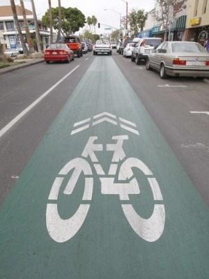
59 Source: streetsblog.org Source: wikipedia Source: streetsblog.org Neighborhood Greenway Elements Source: streetsblog.org Source: ladotbike.gov Greenways Integration Study April

60 Green Streets Green streets incorporate sustainability measures that reduce carbon emissions, utilize stormwater, provide healthy recreation opportunities, and benefit the overall ecosystem. The philosophy of a streetscape ecosystem is to mimic nature, building reciprocal relationships within an interconnected system to sustainably enhance the local environment. Traditional roadway design has focused on speedy removal of water from the street and disposal of the water as waste in storm drains. Green streets reclaim streetwater as a resource and allow it to nourish trees and soils on its path to ground or surface waters. Recommendation: Incorporate sustainable design principles into roadway design to create green streets. Strategies: Install linear, vegetated bioswales that capture rainfall and runoff from adjacent surfaces. Install rain gardens, which are shallow, vegetated depressions in the landscape that are planted with deep-rooted plants and grasses. Utilize permeable pavement in parking lanes and other low-traffic areas. Utilize curb extensions for pedestrian safety and as landscaping opportunities. Integrate stormwater use and reuse principles into the myriad of street design elements. Green Street Elements Source: Federal Highway Administration 60 Broward County Complete Streets


61 Source: Kimley-Horn Source: Kevin Robert Perry Source: Michele Weisbart Green Street Elements Greenways Integration Study April


62 Bike Ramps Bike ramps provide channels within the built environment for bicycle mobility. Bike ramps can take the form of wide curb ramps, wheel gutters on stair cases, and connections between sidewalks and bike lanes at roundabouts and other traffic control devices. Recommendation: Create connections between on-street bike facilities and greenway trails. Strategies: Utilize ramps to connect on-road bike lanes to adjacent greenway trails. Install wheel gutters on staircases to improve bicycle mobility and access. Source: Broward County Greenways Master Plan Source: Steven Vance Source: Kimley-Horn Examples of Bike Ramps 62 Broward County Complete Streets


63 Low Speed Design Principles Low speed design principles utilize engineering strategies to encourage motorists to drive at a slower target speed. Recommendation: As streets are redesigned or resurfaced, incorporate low-speed design principles to help create safe streets for all users. Narrow travel lanes from 12 to 10 or 11. Strategies: Install curb extensions. Follow sidewalk zone design principles including frontage zone, pedestrian zone, furniture zone, and curb zone. Install median refuges. Source: Michele Weisbart Source: Dan Burden Source: Michele Weisbart Source: Kimley-Horn Low Speed Design Principles Greenways Integration Study April


64 Integrated Countywide Bicycle Route Numbering System A integrated countywide bicycle route numbering system utilizes signs and maps to promote the sense that each bicycle route is part of a larger system. Greenway trails and bike lanes can be part of the integrated countywide system. Maps can be printed on signs and placed around the system at various locations and can also be produced on community bike maps that are provided to interested parties to promote bicycling in the area. Typically routes are numbered in a logical order, such as odd numbers for north-south routes and even numbers for east-west routes. Recommendation: Create an integrated countywide bicycle route numbering system using standard MUTCD signs to help give people the sense that each bicycle route is part of a larger system. Strategies: Develop a consistent numbering system that integrates greenway trails and onroad bike lanes that are part of Complete Streets. Install M-series and D-series signs from the MUTCD. Develop trail map signs to supplement the sign strategy. Source: Kimley-Horn Source: MUTCD Source: Kimley-Horn Bicycle Route Numbering System Source: Kimley-Horn 64 Broward County Complete Streets

65 Priority Missing Gaps The study team identified priority missing gaps in the greenways network that could be implemented through integrating greenways and Complete Streets strategies. Recommendation: Build priority missing gaps in the greenway network. Strategies: Implement the missing section of the New River Trail between University Drive and Sewell Lock west of Davie Road) Connect New River Canal Road to the New River Trail. Implement a pilot project crossing for the New River Trail crossing mid-block at one of the major cross-streets. Explore Options for Mid-Block Trail Crossing across U.S. 441 for C-13 Greenway. Connect Parkland and Coconut Creek Greenway Systems via Hillsboro Boulevard and U.S Source: Kimley-Horn The eastern section of the New River Trail Greenway terminates at Sewell Lock Greenways Integration Study April
66 Policy Recommendations and Next Steps 1. Update Broward Greenways Master Plan The Broward Greenways Master Plan was developed in 2002, therefore its maps and recommendations need to be revised to indicate which of the 370 miles of proposed corridors have been completed to date. These revisions should also include which of the specific Barrier Islands Greenway/SR A1A Trail recommendations have been completed or are being planned for future development. In addition, updates to the Greenways Master Plan should include a revised map of priority corridors. Next Steps: A.) Identify progress made from on the proposed corridors depicted in the Greenways Master Plan. I. The Greenways Master Plan Countywide corridor map should be presented to the Broward Complete Streets Team Technical Advisory Committee TAC), Complete Streets Task Team, as well as the MPO and Broward County Planning and Redevelopment Agencies to receive input on the development progress of the corridors depicted on the 2002 map. II. The Greenways Master Plan individual community concept maps should be presented to each of the 19 municipal planning departments to identify what proposed corridor recommendations within these communities have been completed to date. This could be accomplished through a public engagement session where planning officials from each of these municipalities are asked to attend and provide feedback on the Greenways Master Plan proposed 2002 corridor map. III. Furthermore, individual meetings or a subgroup at the public engagement session should be held with planning officials from the municipalities located along the Barrier Islands Greenway/SR A1A corridor to identify which of the greenway plan s specific recommendations listed for this corridor have been completed or are planned for future development. In addition, these communities should verify which recommendations are still valid and prioritize as well as create action items and timelines for those improvements that are yet to be made. The specific recommendations for improvements along the Barrier Islands Greenway/SR A1A corridor are presented in this report, which lists them by community within the corridor Deerfield Beach, Hillsboro Beach, Lighthouse Point, Pompano Beach, Sea Ranch Lakes, Lauderdale-by-the-Sea, Fort Lauderdale, Dania Beach, Hollywood and Hallandale Beach). IV. An updated map of the Greenways Master Plan proposed corridors showing progress made on corridor development from and illustrating gaps should be created and uploaded to the Broward Greenways Master Plan website B.) Revise Broward Greenways Master Plan Priority Corridors Once the development progress of the Greenways Master Plan proposed corridors has been updated, it will be necessary to update the list of priority corridors. 66 Broward County Complete Streets
67 I. It is recommended that the Complete Streets Team TAC assist in identifying priority corridors for the updated Greenways Master Plan. During the process of identifying priority corridors, the following should be referenced: a. MPO Long Range Transportation Plan proposed greenway corridors, bikeways, and pedestrian facilities. b. Complete Streets Team TAC identified a preferred list of Complete Streets pilot projects. c. Complete Streets Team TAC list of recent and funded" Complete Streets projects. II. At least one public engagement session should be held with community stakeholders to receive input for revising and updating the Greenways Master Plan priority corridors. III. An updated map of the Greenways Master Plan proposed priority corridors should be created and presented to the Broward County Board of Commissioners for approval. 2. Promote Municipality Awareness and Integration of the Greenways Master Plan Recommendations in Future Complete Streets Projects The Broward Complete Streets Team TAC as well as individual municipalities should refer to the Broward Greenways Master Plan proposed framework of corridors when considering locations for Complete Streets projects and/or development in general. The County should encourage municipalities to incorporate the Greenways Master Plan recommendations and priority corridors once they have been updated in order to help achieve the Broward Greenways Master Plan vision. In this fashion, the County and its municipalities can work collectively toward a countywide network of interconnected trails and greenways, which provide safe alternative modes of transportation for everyone and raise the quality of life of Broward County residents. Communities that are currently working on identifying Complete Streets and or greenway Projects, such as Deerfield Beach, Tamarac, Hollywood, Fort Lauderdale, Cooper City, Coconut Creek, Davie and North Lauderdale, should be contacted as soon as possible to ensure that the Greenways Master Plan recommendations are integrated into their upcoming plans. In addition, elevating awareness of the importance for municipalities to connect to the greenway network can weigh in on the MPO Board annual revision and vote for priority rankings within the unfunded multi-modal surface transportation project list. 3. Establish Performance Measures to Advance the Greenways Master Plan Vision through Complete Streets Projects The Broward Complete Streets Team TAC should work with the County on defining performance measures for accomplishing completion of the updated Greenways Master Plan priority corridors and recommendations. In order to accomplish the vision of the Greenways Master Plan, goals, action items, as well as a timeline should be established for the County as well as the various municipalities and agencies working towards Complete Streets. Greenways Integration Study April
68 4. Promote and Facilitate Communication between Municipalities and the County Regarding Complete Streets Guidelines The County should continue to promote Complete Streets guidelines to its municipalities. In addition, methods and criteria which municipalities can use for guidance when seeking to implement a Complete Streets project should be developed and clearly communicated to all municipalities. Regular communication between municipalities and the County should be encouraged in order to provide assistance and facilitate the implementation of Complete Streets throughout the county. The Broward Complete Streets Guidelines contain recommendations for a policy framework that help cultivate an understanding and expedite the adoption of Complete Streets practices. A successful policy framework will help local jurisdictions achieve Complete Streets infrastructure improvements. Recently, the Broward Complete Streets Team TAC created a Model Policy Taskforce and Model Plan Taskforce to develop a Complete Streets model policy and a model plan. The model Policy and model Plan will guide local governments in revising internal policies and regulations to help implement Complete Streets. They will also help identify and prioritize Complete Streets corridors, leading to the funding and construction of projects. References Broward County Greenways Master Plan Accessed December 6, 2013: Broward Metropolitan Planning Organization Technical Coordinating Committee Meeting Minutes. January 23, Broward Metropolitan Planning Organization Technical Coordinating Committee Meeting Minutes. August, 28, Broward Metropolitan Planning Organization Technical Coordinating Committee Meeting Minutes. September 25, Broward County Broward Commission Meeting Minutes from September 24, 2013 retrieved from Municode on December 6, 2013: infobase=30036&doc_action=whatsnew Broward County Broward County Moves Forward With Complete Streets Program. Publish September 27, 2013 by Kimberly Maroe. Retrieved December 7, 2013: newsrelease/admindisplaymessages.aspx? intmessageid= Broward County Complete Streets
69 Broward County The Broward County Transit Development Plan. Accessed on December 7, 2013 at: TransitDevelopmentPlan.aspx Broward County. Broward Greenways Master Plan Retrieved December 6, 2013 at: masterplan.aspx Broward MPO Broward Long Range Transportation Plan. Chapter 5 Strategy Page 56. December Amended April 18, Accessed on December 7, 2013 at: projectdocuments.html Broward MPO Technical Coordinating Committee Meeting Minutes. January 23, Broward MPO Community Involvement Roundtable. November 20, Accessed on December 7, 2013 at: CIR_Agenda_-_November_20,_2013.pdf City of Deerfield Beach Deerfield Beach Complete Streets: Safe Streets, Healthy Community. Accessed on December 8, 2013: nid=1079 COMMITMENT Long Range Transportation Plan. Cooper City Comprehensive Plan: Chapter 2 Transportation Element. Adopted by the City Commission of Cooper City on May 28, Updated December 11, Accessed on December 6, 2013: Meeting on December 5, 2013 with Eric Swanson Regional Planner/Policy Analyst, South Florida Regional Planning Council. Sun Sentinel Hollywood seeks input on improving Hollywood Boulevard. Published November 3, 2013 by Susannah Bryan. Accessed December 6, 2013: -sentinel.com/ /news/fl-hollywood- streets-meeting-brf _1_hollywood- boulevard-input-buffered-bike-lanes Sun Sentinel South Florida Roads May Get More Room for Cyclists. Published September 2, 2013 By Angel Streeter. Accessed December 6, 2013: sentinel.com/ /news/fl-protected- bike-lanes _1_bike-lanes-bret- baronak-oakland-park-boulevard Transforming our Community s Health TOUCH) Broward Complete Streets Guidelines Pave Way for Safer, Healthier Streets. Published by Teina Phillips and Christopher Ryan. July 12, Accessed December 7, 2013: CompleteStreetsguidelinesrelease_final.pdf Urban Health Solutions Broward Complete Streets. Accessed on December 7, 2013: completestreets/ Urban Health Solutions Broward Complete Streets Updates. Accessed on December 7, 2013: initiatives/completestreets/updates/ Urban Health Solutions Complete Streets TAC Members. Accessed on December 7, 2013: completestreets/tacmembers/ Greenways Integration Study April
70 Appendix A Agency/Municipality Contact List Broward County Last contacted 12/6/2013 via Phone Call/ Mark Horowitz, Broward County Highway Construction and Engineering Division mhorowitz@broward.org Henry Sniezek, Director Broward County Planning and Environmental Regulation Division hsniezek@broward.org Scott Brunner, TCC/Broward County Traffic Engineering brunner@broward.org Broward County Metropolitan Planning Organization Last contacted 12/6/2013 via Ricardo S. Gutierrez, Broward MPO Transportation Planner/Interim Bicycle and Pedestrian Coordinator gutierrezr@browardmpo.org Call/ Dr. Kim Delany Kdelaney@tcrpc.org Coconut Creek Last contacted 11/20/2013 via Phone Jim Hetzel, Senior Planner, Sustainable City Coordinator jhetzel@coconutcreek.net Sheila Rose, Director of Deparment of Sustainable Development srose@coconutcreek.net Cooper City Last contacted 11/15/2013 via Phone Call Matthew Wood, Growth Management Director , ext. 251 MWood@coopercityfl.org Coral Springs Last contacted 11/20/2013 via Phone Call/ Paul Carpenter, TCC/City of Coral Springs pcarpenter@coralsprings.org Dania Beach Last contacted 12/6/2013 via Corinne Lajoie, Dania Beach Principal City Planner x3704 cchurch@ci.dania-beach.fl.us Davie Last contacted 11/26/2013 via Phone Call/ David Quigley, Planning and Zoning Manager david_quigley@daviefl.gov Deerfield Beach Last contacted 11/15/2013 via Phone Call Amanda Martinez amartinez@deerfieldbeach.com Jerry Ferguson, TCC/City of Deerfield Beach Fort Lauderdale Last contacted 11/20/2013 via Phone Call/ Karen Mendrala, Livability Planner KMendrala@fortlauderdale.gov Heslop Daley, City of Fort Lauderdale Hallandale Beach Last contacted 11/14/2013 via Phone Call Charles Wu, Director of Development Services Beatriz Alvarez, E.I., LEED AP Hillsboro Beach Last contacted 11/14/2013 via Phone Call South Florida Regional Transportation Authority Last contacted 12/6/2013 via Joseph Quinty, Planning and Capital Development quintyj@sfrta.fl.gov South Florida Regional Planning Council Last contacted 12/5/2013 via Meeting Eric Swanson, Regional Planner/Policy Analyst eswanson@sfrpc.com City's Phone Operator Hollywood Last contacted 11/20/2013 via Phone Call Leslie Delmonte, City of Hollywood ldelmonte@hollywoodfl.org Lauderdale-by-the-Sea Last contacted 11/15/2013 via Phone Call/ 70 Broward County Complete Streets
71 Linda Conners, Town Planner, Lauderdale by the Sea Development Services Information Lauderhill Last contacted 11/14/2013 via Phone Call Misty from Department of Environmental and Engineering Services Lighthouse Point Last contacted 11/14/2013 via Phone Call Mr. Robert Collins, Planning and Zoning Official Margate Last contacted 11/15/2013 via Phone Call Nick Cucunato, Roads and Building Foreman Public works Department Miramar Last contacted 12/6/2013 via Lori Hall, TCC/City of Miramar North Lauderdale Last contacted 11/14/2013 via Phone Call Andrew Dinsbury, North Lauderdale Ext. 443 Oakland Park Last contacted 11/20/2013 via Phone Call Ms. Sinclair, Planning and Zoning department Pompano Beach Last contacted 11/20/2013 via Phone Call Kevin Gurley, City of Pompano Beach Amanda Baisley-Parkter, City of Pompano Beach Chris Clemmons, City of Pompano Beach N/A Parkland Last contacted 11/20/2013 Phone Call Sowande Johnson, City Engineer Pembroke Park Last contacted 11/26/2013 via Phone Call Jeanne Peterson, Pembroke Park Tom Wilde, Pembroke Park Pembroke Pines Last contacted 11/18/2013 via Mike Stamm; Economic Development Director Sharon Williams, Comprehensive Planner Plantation Last contacted 11/20/2013 via Phone Call Lisa Bernstein, Engineering department Sea Ranch Lakes Last contacted 11/20/2013 via Phone Call Vicky Stockamore, Realtor of Sea Ranch Lakes newsletter Southwest Ranches Last contacted 11/15/2013 via Phone Call Emily McCord, Southwest Ranches City of Sunrise Last contacted 11/14/2013 via Phone Call Alan Cohen, City of Sunrise Jo Sesodia, City of Sunrise Brad Sling, City of Sunrise City of Tamarac Last contacted 11/14/2013 Phone Call Ann Johnson, City of Tamarac City of Weston Last contacted 11/26/2013 via Phone Call Jeffrey Maxwell, City of Weston Transportation Department West Park Last contacted 11/20/2013 via Phone Call/ Carol Aubrun, City of West Park Wilton Manors Last contacted 11/18/2013 via Phone Call/ Randy Welker, Economic Development Coordinator Greenways Integration Study April
72 Appendix B Broward Mobility Projects 72 Broward County Complete Streets
73 Broward MPO Mobility Projects Phase I PROJECT SEQUENCE LOCATION LIMITS Cost With Design 20%) estimated City LRTP Corridor Total Project cost by City Sidewalks 10 SW 136th Avenue from SW 14th Street to SR 84 $264, Davie Broward Blvd. Bike Lanes 30 SW 130 Ave from I 595 to SW 14th St $575, Davie Broward Blvd. 840, Bike Lanes 350 SW 10th St. / SE 10th ST. from SW 10th way to US 1/Federal Hwy $673, Deerfield Beach US 1 673, Bike Lanes 151 SW 31 Ave from Riverland Road to Broward Blvd $571, Fort Lauderdale Broward Blvd. Sidewalks 152 NW 31 Ave from Riverland Road to Broward Blvd $29, Fort Lauderdale Broward Blvd. Bike Lanes 161 NW 31 Ave from Broward Blvd to Sunrise Blvd $0.00 Fort Lauderdale Broward Blvd. Bike Lanes 170 NW 31 Ave from Sunrise Blvd to Oakland Park Blvd $1,201, Fort Lauderdale Broward Blvd. Sidewalks 190 SW 30th Ave from 2nd CT to Broward Blvd $33, Fort Lauderdale Broward Blvd. Sidewalks 200 SW 28th Terr from SW 4th St to Broward Blvd $117, Fort Lauderdale Broward Blvd. Sidewalks 210 NW 22nd Ave from Broward Blvd to NW 2nd St $18, Fort Lauderdale Broward Blvd. Sidewalks 220 NW 18th Ave from Broward Blvd to NW 2nd St $44, Fort Lauderdale Broward Blvd. Sidewalks 230 NW 14th Ave from Broward Blvd to NW 4th Ave $41, Fort Lauderdale Broward Blvd. Sidewalks 240 SW 12th Ave from Waverly Rd to Broward Blvd $248, Fort Lauderdale Broward Blvd. Sidewalks 250 SW 11th Ave/Palm Ave from SW 5th Place to NW 4th St $87, Fort Lauderdale Broward Blvd. Sidewalks 260 NW 9th Ave from Broward Blvd to NW 6th St $49, Fort Lauderdale Broward Blvd. Sidewalks 270 SW 8th Ave from SW 2nd Street to Broward Blvd $45, Fort Lauderdale Broward Blvd. Bike Lanes 280 SW 4th Ave from SW 34th St to Davie Blvd $800, Fort Lauderdale Broward Blvd. Bike Lanes 291 SW 4th Ave from Davie Blvd to Broward Blvd $0.00 Fort Lauderdale Broward Blvd. 3,289, Sidewalks 300 N/S 13th Street from Johnson St to Washington St $180, Hollywood Hollywood Blvd. Sidewalks 330 Taft St from N 20th to Federal Hwy $217, Hollywood US 1 Sidewalks 330 Sherman St from N 20th to Federal Hwy Hollywood US 1 Sidewalks 330 Thomas St from N 20th to Federal Hwy Hollywood US 1 Sidewalks 330 Lee St from N 20th to Federal Hwy Hollywood US 1 Sidewalks 330 Scott St from N 20th to Federal Hwy Hollywood US 1 Sidewalks 330 Coolidge St from N 20th to Federal Hwy Hollywood US 1 Sidewalks 330 Harding St from N 20th to Federal Hwy Hollywood US 1 Sidewalks 330 Wilson St from N 20th to Federal Hwy Hollywood US 1 Sidewalks 330 Roosevelt St from N 20th to Federal Hwy Hollywood US 1 Sidewalks 330 McKinley St from N 20th to Federal Hwy Hollywood US 1 Sidewalks 330 Cleveland St from N 20th to Federal Hwy Hollywood US 1 Sidewalks 330 Arthur St from N 20th to Federal Hwy Hollywood US 1 Sidewalks 340 N 56th St from Douglas Street to Oak Lake Park $80, Hollywood Hollywood Blvd. Sidewalks 360 Sheridan St from 66th Ave to 72nd Ave $529, Hollywood University Drive 1,006, Sidewalks 100 NW 49th Ave. from NW 26th St to NW 52nd Ave. $80, Lauderdale Lakes Oakland Park Blvd. 80, Sidewalks 110 NW 36th Ave from Broward Blvd to 4th Street $24, Lauderhill Broward Blvd. Sidewalks 120 NW 35th Ave from S of NW 1st Ct to Broward Blvd $52, Lauderhill Broward Blvd. Sidewalks 130 NW 34th Ave from Broward Blvd to NW 6th Street $39, Lauderhill Broward Blvd. Sidewalks 140 NW 32nd Ave from Broward Blvd to Dead End $42, Lauderhill Broward Blvd. 159, Bike Lanes 180 NW 31 Ave from Oakland Park Blvd to Commercial Blvd $886, Oakland Park Oakland Park Blvd. 886, These projects have been programmed for funding in the Broward MPO Transportation Improvement Program TIP), however additional coordination and/or studies may still be required.
74 Broward MPO Mobility Projects Phase I PROJECT SEQUENCE LOCATION LIMITS Cost With Design 20%) estimated City LRTP Corridor Total Project cost by City Sidewalks 310 Pasadena Blvd from University Dr to Pembroke Tower Apartments $317, Pembroke Pines University Drive 317, Sidewalks 20 Broward Blvd from Commodore Dr to Flamingo Rd $122, Plantation Broward Blvd. Sidewalks 40 Broward Blvd from Flamingo Rd to Hiatus Rd $192, Plantation Broward Blvd. Bike Lanes 50 Nob Hill Road from SR 84 to Broward Blvd $556, Plantation Broward Blvd. Sidewalks 60 Nob Hill Road from SR 84 to Central Park Elementary School $207, Plantation Broward Blvd. Bike Lanes 70 Nob Hill Road from Broward Blvd to Sunrise Blvd $1,366, Plantation Broward Blvd. Bike Lanes 80 Broward Blvd from Pine Island Road to West of 82nd Ave $206, Plantation Broward Blvd. Bike Lanes 90 NW 70th Ave from 5th St to 8th St $281, Plantation Broward Blvd. Bike Lanes 320 Pine Island Rd from SR 84 to Broward Blvd $949, Plantation Broward Blvd. 3,883, Bike Lanes 370 Cypress Road from McNab Road to Atlantic Blvd $1,080, Pompano Beach US 1 Bike Lanes 380 McNab Road from Cypress Road to US 1 $608, Pompano Beach US 1 1,689, TOTAL $12,827, ,827, * TRAFFIC $1,282, * MOBILIZATION $1,693, ^ Grand total $15,803, * Maintance of Tarffic MOT): Cost of maintaining traffic during constructions, according to FDOT and Municipalities standards ^Total cost based on FDOT's Long Range Estimates LRE) These projects have been programmed for funding in the Broward MPO Transportation Improvement Program TIP), however additional coordination and/or studies may still be required.
75 Phase II Broward MPO Mobility Projects Phase II FM # PROJECT LOCATION FROM TO Length Feet) Length Miles) Cost City LRTP Corridor Total Project Cost by City BIKE LANE ANDREWS AVE NE 6 STREET OAKLAND PK BLVD 13, $941,845 Fort Lauderdale Oakland Park Blvd SIDEWALK ANDREWS AVE New River Drive LAS OLAS $11,407 Fort Lauderdale Broward Blvd BIKE LANE ANDREWS AVE DAVIE BLVD SE 5 ST 3, $221,281 Fort Lauderdale Broward Blvd BIKE LANE LAS OLAS BLVD ANDREWS AVE SE 15 AVE 4, $341,282 Fort Lauderdale Broward Blvd BIKE LANE BROWARD BLVD SR 7 I 95 11, $421,404 Fort Lauderdale Broward Blvd BIKE LANE US 1 BROWARD BLVD SUNRISE BLVD 5, $2,877,794 Fort Lauderdale Broward Blvd BIKE LANE ANDREWS AVE LAS OLAS NE 6 STREET 3, $4,082,380 Fort Lauderdale Broward Blvd BIKE LANE NW 19 ST SR 7 NW 21/23 AVE 10, $6,433,150 Fort Lauderdale Oakland Park Blvd BIKE LANE US 1 SE 12 ST BROWARD BLVD 5, $2,303,893 Fort Lauderdale Broward Blvd BIKE LANE NE 3 AVE LAS OLAS BLVD SUNRISE BLVD 6, $3,061,410 Fort Lauderdale Broward Blvd SIDEWALK NW 2 ST NW 3 AVE NW 1 AVE $956,832 Fort Lauderdale Broward Blvd BIKE LANE OLD DIXIE HWY NE 13 ST NE 19 ST 4, $1,944,771 Fort Lauderdale Oakland Park Blvd BIKE LANE SE 3 AVE SE 17 ST LAS OLAS BLVD 6, $5,552,748 Fort Lauderdale Broward Blvd BIKE LANE NE 4 AVE SUNRISE BLVD NE 20 ST 5, $3,258,029 Fort Lauderdale Broward Blvd BIKE LANE DIXIE HWY NE 26 ST NE 38/40 ST? 5, $3,749,831 Fort Lauderdale Oakland Park Blvd. $36,158,057 NEW BIKE LANE Hollywood Blvd N/S 26 AVE Dixie Hwy 2, $6,857,371 Hollywood Hollywood Blvd. NEW BIKE LANE Johnson St West of C 10 Canal US 1 8, $9,964,234 Hollywood Hollywood Blvd. $16,821, BIKE LANE SR 7 SUNRISE BLVD NW 29 ST 8, $364,962 Lauderhill Oakland Park Blvd. $364,962 These projects have been programmed for funding in the Broward MPO Transportation Improvement Program TIP), however additional coordination and/or studies may still be required.
76 Broward MPO Mobility Projects Phase II FM # PROJECT LOCATION FROM TO Length Feet) Length Miles) Cost City LRTP Corridor Total Project Cost by City BIKE LANE NE 6 AVE OAKLAND PARK BLVD NE 33 ST 5, $428,223 Oakland Park Oakland Park Blvd. $428, BIKE LANE SR 7 NW 3 ST SUNRISE BLVD 4, $178,666 Plantation Broward Blvd BIKE LANE PETERS RD PINE ISLAND RD TROPICAL WAY 9, $4,041,320 Plantation Broward Blvd BIKE LANE COMMODORE DR SR 84 NW 8 ST 5, $305,625 Plantation Broward Blvd. $4,525, BIKE LANE Sunset Strip Nob Hill Rd Sunrise Blvd 22, $6,231,151 Sunrise Oakland Park Blvd. $6,231,151 NEW BIKE LANE Perimeter Rd Griffin Rd SW 4th Ave 10, $1,614,634 Unincorporated US 1 $1,614,634 $66,144,243 * Maintance of Tarffic MOT): Cost of maintaining traffic during constructions, according to FDOT and Municipalities standards ^Total cost based on FDOT's Long Range Estimates LRE) *^ Grand Total $66,144,243 These projects have been programmed for funding in the Broward MPO Transportation Improvement Program TIP), however additional coordination and/or studies may still be required.
77 Broward MPO Mobility Projects Phase III PROJECT LOCATION FROM TO Length [mi] Length [ft] COST includes 20 % design Costs) City / Town LRTP Corridor Total Project Cost by city Bike Lane Deerfield Beach SW 3rd Avenue Hillsboro Boulevard SW 10th Street $1,499, US 1 Bike Lane Deerfield Beach SE 2nd Avenue Hillsboro Boulevard SE 10th Street $886, US 1 Bike Lane ,670 Deerfield Beach Federal Highway/US 1 Sample Rd. County Line $6,300, US 1 Bike Lane SW 10th Street SW 12th Avenue Natura Blvd ,429 $394, Deerfield Beach US 1 Bike Lane Federal Highway / US ,946 Deerfield Beach 48th Street/49th Street Powerline Road 1 $1,560, Pompano Beach US 1 $10,642, Sidewalk SR 7 & Hollywood Johnson St & Hollywood Hollywood Gardens Blvd N 56th Avenue $1,377, Hollywood Blvd. Bike Lane N 14th Avenue Sheridan Street Johnson Street ,280 $585, Hollywood Hollywood Blvd. Bike Lane N 14th Avenue Johnson Street Washington Street ,808 $505, Hollywood Hollywood Blvd. Bike Lane N. 64th Avenue Hollywood Blvd. Sheridan Street ,973 $1,219, Hollywood Hollywood Blvd. Bike Lane N 56th Avenue Washington St Stirling Road ,306 $2,022, Hollywood Hollywood Blvd. Bike Lane SW 62nd Ave Johnson Street County Line Road / ,262 Hollywood SW 41st Street $5,491, Hollywood Blvd. Sidewalk Just east of N 14th ,013 Hollywood Taft Street N 20th Avenue Avenue $445, Hollywood Blvd. Bike Lane Hallandale Beach ,758 Hollywood Hallandale Beach N 14th Avenue Washington Street Boulevard $725, Hollywood Blvd. $12,372, Bike Lane ,392 Pompano Beach NE 5th Avenue 10th Street Copans Rd $312, US 1 Bike Lane US 1 / Federal ,234 Pompano Beach NE 10th Street Dixie Highway Highway $722, US 1 Bike Lane ,485 Pompano Beach NE 11th Avenue Atlantic Boulevard NE 10th Street $652, US 1 Sidewalk SE 2nd Street SE 11th Avenue Federal Highway ,168 $328, Pompano Beach US 1 Sidewalk US 1 / Federal ,218 Pompano Beach NE 4th Street NE 14th Avenue Highway $182, US 1 Bike Lane NE 15th Avenue Sample Road NE 48th ST ,280 $927, Pompano Beach US 1 $3,125, *^ Grand Total $26,140, $26,140, * Maintance of Tarffic MOT): Cost of maintaining traffic during constructions, according to FDOT and Municipalities standards ^Total cost based on FDOT's Long Range Estimates LRE) These projects have been programmed for funding in the Broward MPO Transportation Improvement Program TIP), however additional coordination and/or studies may still be required.
78 Appendix C 2035 LRTP Cost Feasible Plan CFP) Transit Projects 78 Broward County Complete Streets

 INTE OAKLAND HIATUS RD SR 7 AS SA W Central Broward Transit not final routing) Connection to Cypress Creek Area COMMERCIAL")


79 LEGEND PREMIUM TRANSIT PROJECTS SANDALFOOT BOCA) Premium Rapid Bus Premium High Capacity HWY SAWGRASS EXPY Gateway Hub SR 8 4 ANDREWS AVE SUNRISE BLVD DAVIE BLVD GRIFFIN RD 17TH ST CSWY SHERIDAN ST PINES BLVD PEMBROKE RD SR A1A DIXIE HWY UNIVERSITY DR STIRLING RD HOLLYWOOD BLVD HALLANDALE BEACH BLVD GOLDEN GLADES 53 Page DANIA BEACH BLVD PARK BLVD BROWARD BLVD DAVIE RD 95 / PINE ISLAND RD NOB HILL RD Notes: Illustrative projects are shown for context and are not part of the 2035 Cost Feasible Plan. RSTA TE 5 FLAMINGO RD South Florida East Coast Corridor FEC) INTE OAKLAND HIATUS RD SR 7 AS SA W Central Broward Transit not final routing) Connection to Cypress Creek Area COMMERCIAL BLVD G R TERS TATE 75 ATLANTIC BLVD TU CYPRESS CREEK RD PY EX S The Wave City of Fort Lauderdale Downtown Circulator) 'S ILLUSTRATIVE PROJECTS SR A1A ID A McNAB RD FL OR UNIVERSITY DR SOUTHGATE BLVD Community Hub Anchor Hub SAMPLE RD COPANS RD MOBILITY HUBS DIXIE PI KE Existing Local Bus Route New Local Bus Route RN RIVERSIDE DR BROWARD COUNTY TRANSIT SERVICE CORAL SPRINGS DR CORAL RIDGE DR 50% of the existing transit service s operating and maintenance are funded with existing sources. Local bus services that are partially funded may be restructured to better serve mobility hubs and Premium Transit corridors. Service in Neighboring Counties Peoplemover-SunPort Airport/Seaport) INTERSTATE 75 STRATEGY Exhibit Cost Feasible Transit Projects & Mobility Hubs Map
80 Appendix D 2035 LRTP Cost Feasible Plan CFP) Bicycle Projects 80 Broward County Complete Streets
81 US27 N S RED RD N SR7 S SR7 N SR7 B ANKS RD LYONS RD I95 Exhibit Cost Feasible Bicycle Projects Map LEGEND *Greenways projects shown for context. N US27 N US27 S US27 GLADES PKY I75 ROYAL PALM BLVD S POST RD GRIFFIN RD SHERIDAN ST PINES BLVD SW 172ND AVE SW 172ND AVE WESTON RD SW 160TH AVE SW 154TH AVE SAWGRASS EXPY SW 45TH ST I75 NW 136TH AVE SW 14TH ST STIRLING RD MIRAMAR PKY F L A M I N G O R D F L A M I N G O R D N FLAMINGO RD FLAMINGO RD T U S R D T U S R D H I A H I A S HIATUS RD CORAL RIDGE DR W OAKLAND PARK BLVD N NOB HILL RD N HIATUS RD NOB HILL RD HIATUS RD CORAL SPRINGS DR I595 UNIVERSITY DR SUNSET STRIP NOB HILL RD W SAMPLE RD NW 44TH ST N PALM AVE S PINE ISLAND RD N UNIVERSITY DR S UNIVERSITY DR RIVERSIDE DR TAFT ST JOHNSON ST PEMBROKE RD HOLMBERG RD NW 5TH ST PETERS RD NOVA DR DAVIE RD EX MIRAMAR PKY DAVIE RD WILES RD W ATLANTIC BLVD SOUTHGATE BLVD W BROWARD BLVD ROCK ISLAND RD SR84 NW 56TH AVE FLORIDA TPKE SW 41ST ST W SUNRISE BLVD S SR7 N 46TH AVE NW 31ST AVE W HILLSBORO BLVD W COPANS RD W MCNAB RD NW 62ND ST NW 19TH ST RIVERLAND RD SW 40TH AVE N SR7 SW 30TH AVE WASHINGTON ST N PARK RD NW 21ST AVE NW 48TH ST NW 31ST AVE NW 6TH ST DAVIE BLVD RAVENSWOOD RD N ANDREWS AVE SR84 NE 3RD AVE NE 6TH AVE SW 10TH ST NW 9TH AVE SW 3RD ST W HALLANDALE BEACH BLVD NW 9TH AVE S FEDERAL HWY N DIXIE HWY NE 62ND ST NE 56TH ST BAYVIEW DR NE 26TH ST NE 4TH AVE NE 48TH ST NE 10TH ST E SUNRISE BLVD SE 17TH ST SE 24TH ST ELLER DR N OCEAN DR S OCEAN DR N FEDERAL HWY E MCNAB RD HOLLYWOOD BLVD N OCEAN DR N OCEAN BLVD HILLSBORO MILE Atlantic Ocean STRATEGY Page 58
82 Appendix E 2035 LRTP Cost Feasible Plan CFP) Pedestrian Projects 82 Broward County Complete Streets
83 US27 N FLAMINGO RD S FLAMINGO RD HIATUS RD HIATUS RD RED RD N SR7 S SR7 N SR7 BANKS RD LYONS RD I95 STRATEGY Exhibit Cost Feasible Pedestrian Projects Map LEGEND *Greenways projects shown for context. N US27 N US27 S US27 GLADES PKY I75 ROYAL PALM BLVD S POST RD GRIFFIN RD SHERIDAN ST PINES BLVD SW 172ND AVE SW 172ND AVE WESTON RD SW 160TH AVE SW 154TH AVE SAWGRASS EXPY SW 45TH ST I75 NW 136TH AVE SW 14TH ST STIRLING RD MIRAMAR PKY N FLAMINGO RD FLAMINGO RD S HIATUS RD CORAL RIDGE DR W SAMPLE RD NW 44TH ST W OAKLAND PARK BLVD N NOB HILL RD N HIATUS RD NOB HILL RD HIATUS RD CORAL SPRINGS DR W BROWARD BLVD I595 UNIVERSITY DR SUNSET STRIP NOB HILL RD N PALM AVE S PINE ISLAND RD N UNIVERSITY DR S UNIVERSITY DR RIVERSIDE DR TAFT ST JOHNSON ST PEMBROKE RD HOLMBERG RD NW 5TH ST PETERS RD NOVA DR DAVIE RD EX MIRAMAR PKY DAVIE RD WILES RD W ATLANTIC BLVD SOUTHGATE BLVD ROCK ISLAND RD SR84 NW 56TH AVE FLORIDA TPKE SW 41ST ST W SUNRISE BLVD S SR7 N 46TH AVE NW 31ST AVE W HILLSBORO BLVD W COPANS RD W MCNAB RD NW 62ND ST NW 19TH ST RIVERLAND RD SW 40TH AVE N SR7 SW 30TH AVE WASHINGTON ST N PARK RD NW 21ST AVE NW 48TH ST NW 31ST AVE NW 6TH ST DAVIE BLVD RAVENSWOOD RD N ANDREWS AVE SR84 NE 3RD AVE NE 6TH AVE SW 10TH ST NW 9TH AVE SW 3RD ST W HALLANDALE BEACH BLVD NW 9TH AVE S FEDERAL HWY N DIXIE HWY NE 62ND ST NE 56TH ST BAYVIEW DR NE 26TH ST NE 4TH AVE NE 48TH ST NE 10TH ST E SUNRISE BLVD SE 17TH ST SE 24TH ST ELLER DR N OCEAN DR S OCEAN DR N FEDERAL HWY E MCNAB RD HOLLYWOOD BLVD N OCEAN DR N OCEAN BLVD HILLSBORO MILE Atlantic Ocean 57 Page

84 Broward County Complete Streets Greenways Integration Study
TRANSPORTATION ELEMENT GOALS, OBJECTIVES, AND POLICIES
 TRANSPORTATION ELEMENT GOALS, OBJECTIVES, AND POLICIES GOAL 2 The City shall provide a safe, convenient, effective, and energy efficient multimodal transportation system which is coordinated with the Future
12/9/2013. HOLLYWOOD/PINES CORRIDOR PROJECT AMPO 2013 Annual Conference October 24, Our Perspective. Broward.
 HOLLYWOOD/PINES CORRIDOR PROJECT AMPO 2013 Annual Conference October 24, 2013 Our Perspective Broward Fort Lauderdale 1 Broward Metropolitan Planning Organization Fort Lauderdale Fort Lauderdale Skyline
FDOT D4 Complete Streets
 FDOT D4 Complete Streets Context Sensitive Solutions Directs that complete street solutions will complement the context of the community. Collaborative approach to decision making, project development,
S.R.7/U.S.441 COLLABORATIVE THE COLLEGE OF CORRIDOR KNOWLEDGE
 S.R.7/U.S.441 COLLABORATIVE THE COLLEGE OF CORRIDOR KNOWLEDGE S.R.7 Corridor : A Sense of Place? ANYWHERE USA SR 7: Civilizing the Corridor Bad rules = Bad development! The SR 7 Collaborative A model for
Palm Beach County (University Drive Removal) and Broward County (Transportation Element) Remedial Amendments
 and Broward County (Transportation Element) Remedial Amendments") SR 7/US 441 Transit-Supportive Land Use Planning and Urban Design Assistance (SR 7 Study) Focus TCRPC: Develop detailed analysis of land uses, development regulations, and community visioning all relative
SR 7/US 441 Transit-Supportive Land Use Planning and Urban Design Assistance (SR 7 Study) Focus TCRPC: Develop detailed analysis of land uses, development regulations, and community visioning all relative
Transit / Housing Oriented Redevelopment
 Broward County Urban Planning and Redevelopment Department Kick-Off Meeting October 24, 2007 Transit / Housing Oriented Redevelopment 1 Future Land Use 2 Broward County Charter Voters approved in 1974.
Construction Engineering & Inspection Services Transit Bus Stop Infrastructure for the Broward County Transit Division (BCT)
") Construction Engineering & Inspection Services Transit Bus Stop Infrastructure for the Broward County Transit Division (BCT) 1 Firm Overview 2 We are a well established multi disciplinary firm that has
Construction Engineering & Inspection Services Transit Bus Stop Infrastructure for the Broward County Transit Division (BCT) 1 Firm Overview 2 We are a well established multi disciplinary firm that has
Eastern Terminus TECHNICAL MEMORANDUM CENTRAL BROWARD EAST-WEST TRANSIT ANALYSIS BROWARD COUNTY, FLORIDA
 Eastern Terminus TECHNICAL MEMORANDUM CENTRAL BROWARD EAST-WEST TRANSIT ANALYSIS BROWARD COUNTY, FLORIDA FINANCIAL PROJECT ID NUMBER 411189-2-22-01 FLORIDA DEPARTMENT OF TRANSPORTATION DISTRICT 4 Prepared
TRANSPORTATION ELEMENT
 TRANSPORTATION ELEMENT GOAL I: To create and maintain a safe, efficient and aesthetic transportation system that encourages multi-modal transportation and promotes the mobility strategies of the Ocala
MEMORANDUM AGENDA ITEM #6c
 South Florida Regional Planning Council MEMORANDUM AGENDA ITEM #6c DATE: FEBRUARY 1, 2010 TO: FROM: SUBJECT: COUNCIL MEMBERS STAFF CITY OF PARKLAND PROPOSED COMPREHENSIVE PLAN AMENDMENT (ALTERNATIVE REVIEW)
Potential Green Infrastructure Strategies May 6, 2015 Workshop
 Potential Green Infrastructure Strategies May 6, 2015 Workshop Background The City of Cortland is developing the Tioughnioga Urban Headwaters Green Infrastructure Action Plan with funding from the National
Public input has been an important part of the plan development process.
 Lakewood s Comprehensive Plan recognizes that transportation helps shape the community, and that the way the community provides for the safe and efficient movement of people affects the character of the
Transportation. Strategies for Action
 Transportation A major priority for the Overlake Neighborhood is to develop a multimodal transportation system. To achieve this system, a balance has to be found among travel, circulation and access needs;
Executive Summary. NY 7 / NY 2 Corridor
 Executive Summary NY 7 / NY 2 Corridor Transportation and Land Use Study December 2005 Prepared for: Town of Colonie Capital District Transportation Committee Prepared by: Introduction: Land use decisions
Route 1 Corridor Study
 Route 1 Corridor Study Westbrook, Connecticut A Vision for the Connecticut Shoreline Public Informational Meeting July 28, 2015 Lower Connecticut River Valley Council of Governments Fitzgerald & Halliday,
SOLICITATION J P1 Construction Engineering Services for Wiles Road Riverside Drive to Rock Island Road
 SOLICITATION J2112395P1 Construction Engineering Services for Wiles Road Riverside Drive to Rock Island Road Qualifications and Experience of Key Personnel Dan Tintner, P.E., Project Manager/Senior Project
Local/Regional Coordination on Green Infrastructure. Sustainability Stewards Workshop May 10, 2016
 Local/Regional Coordination on Green Infrastructure Sustainability Stewards Workshop May 10, 2016 Green infrastructure is an interconnected system of natural areas and open space that conserves ecosystem
CITY OF CHARLOTTESVILLE, VIRGINIA CITY COUNCIL AGENDA
 CITY OF CHARLOTTESVILLE, VIRGINIA CITY COUNCIL AGENDA Agenda Date: December 16, 2013 Action Required: Adoption of Resolution Presenter: Staff Contacts: Title: James E. Tolbert, AICP, Director of NDS James
City of Fort Lauderdale UPTOWN URBAN VILLAGE. Public Workshop December 7, 2016
 Public Workshop December 7, 2016 Workshop Agenda Introductions Project Presentation o o o History Project Scope/Timeline Character of Study Area o o o o Land Use Public Realm/Pedestrian Mobility Multimodal
The Illinois Department of Transportation and Lake County Division of Transportation. Route 173, including the Millburn Bypass
 The Illinois Department of Transportation and Lake County Division of Transportation welcome you to this Public Hearing for U.S. Route 45 from Illinois Route 132 to Illinois Route 173, including the Millburn
TAC/CAC, TPO Project Update February 2016
 A1A MULTIMODAL CORRIDOR PLANNING AND ENGINEERING ANALYSIS Florida Department of Transportation TAC/CAC, TPO Update February 2016 PRESENTATION FOOTERT Meeting Agenda What We Plan To Discuss Background New
MEMORANDUM AGENDA ITEM #IV.C
 MEMORANDUM AGENDA ITEM #IV.C DATE: NOVEMBER 27, 2017 TO: FROM: COUNCIL MEMBERS STAFF SUBJECT: LOCAL GOVERNMENT COMPREHENSIVE PLAN PROPOSED AND ADOPTED AMENDMENT CONSENT AGENDA Pursuant to Section 163.3184,
Corridor Vision. 1Pursue Minnehaha-Hiawatha Community Works Project. Mission of Hennepin County Community Works Program
 1Pursue Minnehaha-Hiawatha Community Works Project Minnehaha-Hiawatha Community Works is a project within the Hennepin Community Works (HCW) program. The mission of the HCW program is to enhance how the
DRAFT Subject to modifications
 TREASURE COAST REGIONAL PLANNING COUNCIL DRAFT M E M O R A N D U M To: Council Members AGENDA ITEM 7C From: Date: Subject: Staff September 17, 2010 Council Meeting Commuter Rail Update Resolution of Support
Mississippi Skyway Preliminary Engineering Report
 EXECUTIVE SUMMARY Mississippi Skyway Preliminary Engineering Report CITY OF RAMSEY, MINNESOTA DECEMBER 2014 City of RAMSEY EXECUTIVE SUMMARY Project Need and Intent The Mississippi Skyway pedestrian bridge
Pedestrian and Bike Bridge LOGO
 6.2.2 Pedestrian and Bike Bridge The proposed pedestrian and bike crossing re-envisions the existing bridge at Pismo Creek on Cypress Street. The bridge is currently underutilized by vehicular through
PD&E STUDY SR 9/I-95 FROM SOUTH OF SR 870/COMMERCIAL BOULEVARD TO NORTH OF CYPRESS CREEK ROAD FM # ETDM 14222
 PD&E STUDY SR 870/COMMERCIAL BOULEVARD TO NORTH OF CYPRESS CREEK ROAD FM # 435808-1-22-02 ETDM 14222 WELCOME TO THE KICK-OFF MEETING May 24, 2016 1 1 2 3 4 5 6 PLANNING PROJECT DEVELOPMENT AND ENVIRONMENT
HILLSBOROUGH COUNTY Greenways and Trails Plan Update. Executive Summary. Date
 HILLSBOROUGH COUNTY Greenways and Trails Plan Update Executive Summary Date PURPOSE AND PROJECT OVERVIEW The Hillsborough County Greenways Master Plan (1995) and the City of Tampa s Greenways and Trails
1.0 Introduction. Purpose and Basis for Updating the TMP. Introduction 1
 1.0 Introduction The Town of Castle Rock is situated between the metropolitan areas of Denver and Colorado Springs, amidst a unique terrain of rolling hills, mesas, ravines, and waterways. Like many Front
3. VISION AND GOALS. Vision Statement. Goals, Objectives and Policies
 Vision Statement Queen Creek s interconnected network of parks, trails, open spaces and recreation opportunities provide safe and diverse activities and programs that sustain its unique, small town, equestrian
Pinellas County Greenways
 Pinellas County Greenways USING GREENWAYS TO LINK OPEN SPACES The Florida Greenways Commission has defined a greenway as...a corridor of protected open space that is managed for conservation and/or recreation.
NEIGHBORHOOD DESIGN ELEMENT
 NEIGHBORHOOD DESIGN ELEMENT INTRODUCTION The following recommendations constitute an urban design oriented "neighborhood analysis" of Plantation. It is an optional Comprehensive Plan Element. The five
DRAFT Subject to Modifications
 TREASURE COAST REGIONAL PLANNING COUNCIL M E M O R A N D U M To: Council Members AGENDA ITEM 8 From: Date: Subject: Staff May 19, 2017 Council Meeting Florida Department of Transportation Complete Streets
TREASURE COAST REGIONAL PLANNING COUNCIL M E M O R A N D U M. To: Council Members AGENDA ITEM 5H
 TREASURE COAST REGIONAL PLANNING COUNCIL M E M O R A N D U M To: Council Members AGENDA ITEM 5H From: Date: Subject: Staff October 17, 2008 Council Meeting Local Government Comprehensive Plan Review Draft
Northeast Everglades Natural Area
 Northern Palm Beach County Natural Areas Master Plan Northeast Everglades Natural Area August 3, 2006 GLATTING JACKSON KERCHER ANGLIN LOPEZ RINEHART, INC. Community Planning 1 Public Land Partners Agenda
1.0 INTRODUCTION 1.1 TH 14 WEST STUDY AREA Project Description Functional Classification Purpose of the Project
 1.0 INTRODUCTION 1.1 TH 14 WEST STUDY AREA 1.1.1 Project Description The Trunk Highway (TH) 14 West Corridor is a two-lane roadway approximately 22 miles in length. Located in Nicollet County, the corridor
Beachside Redevelopment Committee
 Beachside Redevelopment Committee DRAFT FINAL RECOMMENDATIONS MARCH 22, 2018 This is a new slide 2 This is a new slide Table of Contents I. Introduction and Overview II. III. Community Improvements and
RECREATION AND OPEN SPACE ELEMENT GOALS, OBJECTIVES, AND POLICIES
 RECREATION AND OPEN SPACE ELEMENT GOALS, OBJECTIVES, AND POLICIES Goal 7 To provide park facilities, recreation programs, and open space resources that are safe, adequate, and accessible to all City residents,
CHAPTER 1. Ms. Guajardo s Class - Central Elementary CH 1 1
 INTRODUCTION CHAPTER 1 Ms. Guajardo s Class - Central Elementary CH 1 1 1.1 SETTING South Centre City is a linear corridor south of Downtown Escondido paralleling Centre City Parkway and South Escondido
Mendota-Lebanon Hills Greenway Master Plan Executive Summary. August draft for more information visit
 Mendota-Lebanon Hills Greenway Master Plan Executive Summary August 2013 draft for more information visit www.hkgi.com/projects/dakota INTRODUCTION The Mendota-Lebanon Hills Greenway Master Plan portrays
Issues Requiring Future Study
 Issues Requiring Future Study Transportation planning is an ongoing process that tends to identify new issues as it finds solutions for others. Some issues are so complex that a solution to one problem
List of Priority Projects
 List of Priority Projects Fiscal Years 2019-20 to 2023-24 June 25, 2018 Amended December 17, 2018 Metropolitan Transportation Planning Organization for the Gainesville Urbanized Area List of Priority
G. RECREATION AND OPEN SPACE ELEMENT. The following summarizes the Recreation and Open Space Element:
 G. RECREATION AND OPEN SPACE ELEMENT The purpose of the Element is to provide the framework and direction for a comprehensive system of public and private sites for recreation, including, but not limited
A larger version of this map is located on the last page of this PDF.
 MAP Committee Input McLoughlin Area Draft Vision Map A larger version of this map is located on the last page of this PDF. 1. The map above is intended to portray a vision for the McLoughlin area. It highlights
This page left intentionally blank.
 July 2012 This page left intentionally blank. Table of Contents Appendix A : Project Development Checklist Appendix B: At-Grade Rail Crossings Appendix C: Maintenance and Operations Examples Appendix D:
Implementation Guide Comprehensive Plan City of Allen
 Implementation Guide 2030 Comprehensive Plan City of Allen DRAFT 2015 Implementation Guide Allen 2030 Comprehensive Plan INTRODUCTION The Comprehensive Plan serves as a guide for the growth and development
Date: April 10, 2017 City Council Work Session April 24, 2017: Status Report on the Comprehensive Plan Update and Transportation Master Plan
 AGENDA REPORT To: From: By: Honorable Mayor and City Council Members Warren Hutmacher, City Manager Sharon Ebert, Director Community Development Date: April 10, 2017 Agenda: City Council Work Session April
NORTH-SOUTH CORRIDOR STUDY EXECUTIVE SUMMARY. Executive Summary
 Executive Summary Background As congestion continues to affect mobility in the region, the Ozarks Transportation Organization (OTO) is particularly concerned with traffic movement. The North-South Corridor
Rich Valley Greenway Master Plan. Central Greenway Connectivity Study
 Rich Valley Greenway Master Plan Central Greenway Connectivity Study Dakota County Planning Commission February, 2017 Rich Valley Greenway Master Plan Dakota County Greenway Vision Establish a County-wide
DRAFT Civic Center Station Area Plan. Executive Summary
 DRAFT Civic Center Station Area Plan Executive Summary This project is funded in part through the Metropolitan Transportation Commission s Station Area Planning Program. The preparation of this report
BROOKHILL NEIGHBORHOOD MODEL ZONING MAP AMENDMENT PREFACE TO APPLICATION
 BROOKHILL NEIGHBORHOOD MODEL ZONING MAP AMENDMENT PREFACE TO APPLICATION June 15, 2015 Revised: August 1, 2016 I. VISION Brookhill is a proposed community based upon the principles of Albemarle County
38 Queen s University Campus Master Plan Part 1
 38 Queen s University Campus Master Plan Part 1 46 The Campus at the City Scale Chapter 4 The Campus at the City Scale 39 Queen s is an urban University centrally located in Kingston. Decisions made by
CHAPTER 7: Transportation, Mobility and Circulation
 AGLE AREA COMMUNITY Plan CHAPTER 7 CHAPTER 7: Transportation, Mobility and Circulation Transportation, Mobility and Circulation The purpose of the Transportation, Mobility and Circulation Chapter is to
The Need to Develop a Transit Ready Community
 Evaluation & Appraisal Report (EAR) Major Issue # 6 The Need to Develop a Transit Ready Community July 3, 2007 EAR Major Issue # 6 Transit Ready Existing Comp Plan policies apply only to Indiantown Road:
Introduction. Chapter 1. Purpose of the Comprehensive Plan Plan Organization Planning Process & Community Input 1-1
 Chapter 1 Introduction Lakewood 2025: Moving Forward Together Purpose of the Comprehensive Plan Plan Organization Planning Process & Community Input 1-1 Purpose of the Comprehensive Plan The Comprehensive
Provide and maintain sufficient public parks, recreation facilities, and open space to meet the recreational needs of County residents and visitors.
 (ROS) Goal Provide and maintain sufficient public parks, recreation facilities, and open space to meet the recreational needs of County residents and visitors. OBJECTIVE ROS.01 The County shall acquire,
Northwest Rail Corridor and US 36 BRT Development Oriented Transit Analysis 4.4 STATION AREA FINDINGS
 4.4 STATION AREA FINDINGS Each station is different, and each one requires a separate set of recommendations based on the vision for the site. This section outlines an initial TOD strategy and recommendations
Fifth and Detroit Street Design May 2017 Capital Improvements Committee. DOWNTOWN Street Design
 1 Fifth and Detroit Street Design May 2017 Capital Improvements Committee Agenda 2 Review Street Configuration Prior Meeting Review Outreach Synopsis Functional Street Design Refinements Curb Edge, Turning
TREASURE COAST REGIONAL PLANNING COUNCIL M E M O R A N D U M. To: Council Members AGENDA ITEM 5I
 TREASURE COAST REGIONAL PLANNING COUNCIL M E M O R A N D U M To: Council Members AGENDA ITEM 5I From: Date: Subject: Staff December 12, 2008 Council Meeting Local Government Comprehensive Plan Review Town
Report to: Development Services Committee Report Date: April 24, 2017
 SUBJECT: Cornell Rouge National Urban Park Gateway - Report on Design Charrette and Next Steps PREPARED BY: Lilli Duoba, MES, MCIP, RPP, Manager, Natural Heritage (ext. 7925) REVIEWED BY: Marg Wouters,
IMPLEMENTATION STRATEGIES. In This Chapter. Goals & Strategies 182 Project List 183 Future Land Use 186 CHAPTER 11 IMPLEMENTATION STRATEGIES
 In This Chapter Goals & Strategies 182 Project List 183 Future Land Use 186 11 IMPLEMENTATION STRATEGIES NORTH AUGUSTA, SC 2017 COMPREHENSIVE PLAN 179 Individual commitment to a group effort that is what
New York Avenue Streetscape and Trail Project Public Meeting #1 Summary
 New York Avenue Streetscape and Trail Project Public Meeting #1 Summary I. King Jordan Student Academic Center (SAC) Gallaudet University, Washington, DC February 23, 2017 Table of Contents 1.0 Introduction...
PARTF Scoring System for Grants
 PARTF Scoring System for Grants The members of the N.C. Parks and Recreation Authority use the PARTF scoring system as one of several tools to select grant recipients. Please provide all of the information
City of Plantation Midtown District Conceptual Plan Implementation Update. City Council Presentation February 22, 2017
 City of Plantation Midtown District Conceptual Plan Implementation Update City Council Presentation February 22, 2017 Purpose of Presentation The purpose of this presentation is to: 1. Review key concepts
CHAPTER 8. Mrs. Zimman s Class - Central Elementary
 SUSTAINABILITY CHAPTER 8 Mrs. Zimman s Class - Central Elementary 8.1 OVERVIEW Green infrastructure also known as low impact development (LID) and environmental or sustainable site design is an environmentally
master plan of highways bus rapid transit amendment
 Scope of Work master plan of highways bus rapid transit amendment September 2011 Montgomery County Planning Department M-NCPPC MontgomeryPlanning.org 1 Scope of Work master plan of highways bus rapid transit
2017 General Obligation Bond
 2017 General Obligation Bond Presentation of Public and Council Projects to the Transportation & Mobility Stakeholder Committee April 13, 2017 Agenda Deferred Maintenance Project Development Process Projects
Scope of Services. River Oaks Boulevard (SH 183) Corridor Master Plan
 Corridor Master Plan") Scope of Services River Oaks Boulevard (SH 183) Corridor Master Plan PROJECT AREA The project area consists of the River Oaks Boulevard (SH 183) corridor bounded by SH 199 at the northern end and the Trinity
Scope of Services River Oaks Boulevard (SH 183) Corridor Master Plan PROJECT AREA The project area consists of the River Oaks Boulevard (SH 183) corridor bounded by SH 199 at the northern end and the Trinity
DISCUSSION TOPIC: ST JOHNS RIVER & ITS TRIBUTARIES (BPII) 2030 COMPREHENSIVE PLAN POLICES AND REGULATORY FRAMEWORK
 2030 COMPREHENSIVE PLAN POLICES AND REGULATORY FRAMEWORK") DISCUSSION TOPIC: ST JOHNS RIVER & ITS TRIBUTARIES (BPII) 2030 COMPREHENSIVE PLAN POLICES AND REGULATORY FRAMEWORK St. John s River & Its Tributaries Issue Summary: The St. Johns River is an important
DISCUSSION TOPIC: ST JOHNS RIVER & ITS TRIBUTARIES (BPII) 2030 COMPREHENSIVE PLAN POLICES AND REGULATORY FRAMEWORK St. John s River & Its Tributaries Issue Summary: The St. Johns River is an important
SUBJECT: LOCAL GOVERNMENT COMPREHENSIVE PLAN PROPOSED AND ADOPTED AMENDMENT CONSENT AGENDA
 MEMORANDUM AGENDA ITEM #IV.C DATE: APRIL 15, 2019 TO: FROM: COUNCIL MEMBERS STAFF SUBJECT: LOCAL GOVERNMENT COMPREHENSIVE PLAN PROPOSED AND ADOPTED AMENDMENT CONSENT AGENDA Pursuant to the 1974 Interlocal
Transportation Land Use Integration & Regional Planning. Don Kostelec, AICP Senior Planner, Louis Berger Group February 1, 2010
 Transportation Land Use Integration & Regional Planning Don Kostelec, AICP Senior Planner, Louis Berger Group February 1, 2010 Transportation Land Use Integration DOT-HUD-EPA Sustainable Communities Initiative
GOALS, OBJECTIVES, POLICIES & PROGRAMS
 Chapter 5 GOALS, OBJECTIVES, POLICIES & PROGRAMS 5.1 Goals, Objectives, Policies & Programs This is a joint plan adopted by both the Village of Waunakee and the Town of Westport. Both communities will
Wiles Road from University Drive to Riverside Drive
 Wiles Road from University Drive to Riverside Drive Presented to: Broward County WSP Parsons Brinckerhoff is now Presented by: WSP USA Inc. Our Team.. Introduction / Project Team Cecilia Villoria, PE Project
Whitemarsh Comprehensive Plan Update: Housing & Land Use. Public Workshop #3: September 20, 2018
 Whitemarsh Comprehensive Plan Update: Housing & Land Use Public Workshop #3: September 20, 2018 Agenda Welcome Process Recap What We ve Heard The Plan Framework Review of Recommended Actions Land Use Housing
Municipality of Anchorage. Community Council Survey Capital Projects Needs Ranking Survey (ALPHABETICAL) Airport Heights
 Airport Heights") ANCHORAGE PARKS & RECREATION Nichols Park Design and improve neighborhood park 2008 Challenge Grant applicant. 2008 $500K State Grant for Neighborhood Parks. Tikishla Park Lighting, paved parking, hockey
ANCHORAGE PARKS & RECREATION Nichols Park Design and improve neighborhood park 2008 Challenge Grant applicant. 2008 $500K State Grant for Neighborhood Parks. Tikishla Park Lighting, paved parking, hockey
COMPLETE GREEN STREET CHECKLIST
 COMPLETE GREEN STREET CHECKLIST This document was developed to dissect the structure of an urban street and explore opportunities to make our streets more complete while also integrating green street strategies.
Building Great Neighbourhoods. Strathcona
 Building Great Neighbourhoods Strathcona March 21, 2018 Becky Redford Project Manager, Planning & Design Building Great Neighbourhoods Integrated Infrastructure Services Welcome and Purpose To provide
Honorable Mayor and Members of the City Council. Submitted by: Eric Angstadt, Director, Planning and Development
 Office of the City Manager ACTION CALENDAR January 29, 2013 To: From: Honorable Mayor and Members of the City Council Christine Daniel, City Manager Submitted by: Eric Angstadt, Director, Planning and
FUTURE LAND USE ELEMENT
 FUTURE LAND USE ELEMENT GOAL I: To create and sustain a great place to live, play, and prosper Objective 1: The City of Ocala shall incorporate the principles and strategies of the Ocala 2035 Vision into
Midtown Greenway Land Use and Development Plan Executive Summary
 Midtown Greenway Land Use and Development Plan Executive Summary Introduction The Midtown Greenway Land Use and Development Plan sets policy direction for land use and development in the Midtown Greenway
Rosemount Greenway Master Plan Executive Summary. draft. Spring for more information visit
 Rosemount Greenway Master Plan Executive Summary Spring 2012 draft for more information visit www.hkgi.com/projects/dakota INTRODUCTION The Rosemount Greenway Master Plan portrays a vision to establish
FOUR MILE RUN VALLEY WORKING GROUP AND CHARGE
 FOUR MILE RUN VALLEY WORKING GROUP AND CHARGE Adopted April 16, 2016 Amended July 19, 2016 Overview of Integrated Effort The overall goal of the Four Mile Run Valley (4MRV) initiative is to develop a comprehensive
Transportation Projects Quarterly Report. Morrisville Planning Department May 22, 2018
 Transportation Projects Quarterly Report Morrisville Planning Department May 22, 2018 Transportation Improvements Most Common Ways the Town secures transportation improvements: 1. Development 2. Grant
The State Road 7/U.S. 441 Collaborative. 8 th Annual New Partners for Smart Growth Building Safe, Healthy and Livable Communities
 The State Road 7/U.S. 441 Collaborative 8 th Annual New Partners for Smart Growth Building Safe, Healthy and Livable Communities J. Gary Rogers City of Lauderdale Lakes Florida Community Redevelopment
Office of Greenways & Trails Providing Statewide Leadership and Coordination. Southeast Greenways and Trails Summit October 1-3, 2017
 Office of Greenways & Trails Providing Statewide Leadership and Coordination Southeast Greenways and Trails Summit October 1-3, 2017 1 Office of Greenways and Trails The Office of Greenways and Trails
Small Area Plan. South Gateway
 Small Area Plan Adopted May 12, 2008 South Gateway Purpose. The South Gateway Small Area Plan defines the City s expectations for the future of the southern entrance to the City at Interstate 85 and Highway
AGENDA ITEM 3A Red Hills Coastal Parkway
 March 26, 2007 AGENDA ITEM 3A Red Hills Coastal Parkway REQUESTED BY: CRTPA Members TYPE OF ITEM: Discussion STATEMENT OF ISSUE At the January 22, 2006 Capital Region Transportation Planning Agency (CRTPA)
PLAN ELEMENTS WORKSHOP. April 5, 2016
 PLAN ELEMENTS WORKSHOP April 5, 2016 needs more housing. But there is no one-size fits-all solution. Every neighborhood has its own character. In some places, density is not only appropriate it is badly
Somers Point Master Plan
 Somers Point Master Plan Progress Report and Public Meeting August 20, 2014 Master Plan Reexamination Municipal Land Use Law require that all municipalities reexamine their master plan every ten years.
SPRINGHILL LAKE TRANSIT VILLAGE
 Greenbelt Metro Area Sector Plan - Subarea Design Policies and Guidelines - Springhill Lake Transit Village 113 SPRINGHILL LAKE TRANSIT VILLAGE Residential Neighborhood and Village Center CONCEPT Springhill
People who are members of historically disenfranchised racial, ethnic, cultural, and other identity groups are encouraged to apply.
 CALL TO ARTISTS REQUEST FOR QUALIFICATIONS CITY OF TACOMA MUNICIPAL ART PROGRAM East 64 th Streetscape, Tacoma, WA APPLICATION DEADLINE October 10, 2018, 11:59pm BUDGET $72,000, all-inclusive SUMMARY The
Panama City Beach Community Redevelopment Agency Condo Con Property Owner Conference & Expo November 14, 2014
 Panama City Beach Community Redevelopment Agency Condo Con Property Owner Conference & Expo November 14, 2014 Front Beach Road CRA On November 30, 2000, the City created the Panama City Beach Community
John M. Fleming Managing Director, Planning and City Planner. Old East Village Dundas Street Corridor Secondary Plan Draft Terms of Reference
 Report to Planning and Environment Committee To: From: Subject: Chair and Members Planning & Environment Committee John M. Fleming Managing Director, Planning and City Planner Old East Village Dundas Street
Ten Mile Creek Planning Area
 PLANNING AREA POLICIES TEN MILE CREEK Ten Mile Creek Planning Area Location and Context The Ten Mile Creek Planning Area ( Ten Mile Creek area ) is located south of the current Boise AOCI, generally south
The transportation system in a community is an
 7 TRANSPORTATION The transportation system in a community is an important factor contributing to the quality of life of the residents. Without a sound transportation system to bring both goods and patrons
Gratigny Parkway East Extension Project Development & Environment (PD&E) Study
 Study") Gratigny Parkway East Extension Project Development & Environment (PD&E) Study Session 4: Presentation of Charrette Results December 8, 2010 MDX Work Program #: 92407 ETDM#: 11500 Project Location & Description
Gratigny Parkway East Extension Project Development & Environment (PD&E) Study Session 4: Presentation of Charrette Results December 8, 2010 MDX Work Program #: 92407 ETDM#: 11500 Project Location & Description
Route 347. New York State Department of Transportation Region 10, Long Island. THE GREENING of ROUTE 347
 The GREENING of Route 347 The Greening of Route 347 The Greening of Route 347: History 3 The Greening of Route 347 4 The Greening of Route 347 5 The Greening of Route 347 Smith Haven Mall 6 The Greening
SCTPO Project Summary September 2014
 A1A MULTIMODAL CORRIDOR PLANNING AND ENGINEERING ANALYSIS Florida Department of Transportation SCTPO Project Summary September 2014 PRESENTATION FOOTER Meeting Agenda What We Plan To Do Project Background
Mendota Heights 2040 Comprehensive Plan Draft Vers
 4 Parks and Trails The City of Mendota Heights boasts a variety of recreational and open space opportunities. Few cities can claim access to regional trails, riverside and lakeside parks, scenic bluffs
Panama City Beach Community Redevelopment Agency ON THE MOVE IN PCB
 Panama City Beach Community Redevelopment Agency ON THE MOVE IN PCB Program Goals, Activities and Accomplishments I. Beach Front Multi-modal Transportation, Aesthetic and Parking Improvements III. Connector