APPROVED BY COUNCIL September 28, 2004 REVISIONS APPROVED BY COUNCIL May 18, 2010
|
|
|
- Rudolph Spencer
- 6 years ago
- Views:
Transcription

1 APPROVED BY COUNCIL September 28, 2004 REVISIONS APPROVED BY COUNCIL May 18, 2010
2 TABLE OF CONTENTS 1.0 INTRODUCTION Organization of the Plan Location and Context Site History & Use Existing Residents Rationale for Redevelopment Policy Framework Consultation Process Technical Studies ARP OBJECTIVES THE CONCEPT PLAN Concept Overview Land Use Areas POLICY SECTION General Policies Socio-Economic Policies Environmental Policies Servicing & Engineering Policies Transportation Policies Land Use and Urban Design Policies Residential Development Policies Commercial Development Policies Open Space Policies Development Staging Policies Plan Implementation Policies 34 LIST OF EXHIBITS Figure 1 ARP Location and Boundary 2 Figure 2 Aerial Photograph Figure 3 Land Use Concept 11 Figure 4 Environmental Sensitivity 17 Figure 5 Utility Servicing 19 Figure 6 Transportation 23 Figure 7 Open Space and Trails 30 Figure 8 Development Staging 33 APPENDIX A Restwell Residents Guidelines APPENDIX B Urban Design Guidelines
3 SPRING CREEK MOUNTAIN VILLAGE AREA REDEVELOPMENT PLAN 1.0 INTRODUCTION AND BACKGROUND 1.1 ORGANIZATION OF THE PLAN The Spring Creek Mountain Village Area Redevelopment Plan (ARP) includes two main parts. The main body of the ARP is contained in Sections 1 through 4 and includes the background, objectives, concept plan and supporting policy statements. Appendix A contains the Spring Creek Mountain Village Urban Design Guidelines. The intent of these guidelines is to provide additional information on the design philosophy and standards envisaged for the plan. While some flexibility must exist, it is expected that development will adhere substantially to these guidelines. 1.2 LOCATION AND CONTEXT The ARP covers lands generally south of 8 th (Main) Street, east of Spring Creek and west of the CPR tracks. Figure 1: ARP Location & Boundary shows the limits of the study area. Figure 2: Aerial Photograph shows a year 2002 aerial view of the study area. 1.3 SITE HISTORY AND USE Since development of the land as a mobile home park in the late 1950s, Restwell has provided an important source of entry level housing within the Canmore context. Prior to that time, the land was the site of the Canmore dairy farm owned and operated by the Kernick family. Today much of the site is operated as a lease land mobile home community with approximately 220 mobile homes, 6 Cabins and 250 recreational vehicle sites. Two permanent residential homes and various ancillary buildings are also located on the site. When full, the Restwell population can exceed 1000 people including permanent and seasonal residents. 1.4 EXISTING RESIDENTS To ensure that the permanent residents in Restwell Trailer Park were fully considered in the redevelopment plan, two Restwell Resident Surveys 1


4 2


5 3
6 were conducted in The self-report surveys were designed to gather information about the residents living in Restwell, existing on-site housing, residents opinions about the redevelopment and future housing intentions and preferences of the residents and their families. The response rate was over 65% for both surveys. Additional feedback from Restwell residents was received during presentations to the residents and public open houses and continues on an on-going basis though the Restwell resident representatives on the Study Team Committee. 1.5 RATIONALE FOR REDEVELOPMENT Land Use Intensity: Because of the relatively low density nature of the existing housing, redevelopment will provide an opportunity for better utilization of the land through increased development density and variety of built form Positive Environmental Change: The creeks, creek banks and wetland area in the vicinity of the existing boardwalk will be transferred to Town ownership in the form of environmental reserves. The rehabilitation of disturbed creek bank areas will also occur through redevelopment Proximity to Town Services: The Restwell site is close to down town, schools, parks and other Town facilities and services. The location provides an opportunity to develop complementary residential, commercial and open space uses within close walking distance of downtown Economic Benefit: Redevelopment will produce positive economic benefits both in terms of employment and property tax revenue to the Town of Canmore Infrastructure Upgrading: Much of the existing utility and building infrastructure in Restwell is old and in need of replacement. Redevelopment will allow this upgrading to occur on a phased basis Housing and Tenure: The existing homes and tenure makes potential redevelopment more feasible than traditional fee simple homes on permanent foundations. The existing turnover in home sales and resident movements in and out of the park also helps to facilitate redevelopment flexibility over time Natural Setting: The site location adjacent to Spring Creek and Policeman s Creek and the panoramic views of the surrounding mountains, makes this site highly desirable for various forms of residential, commercial and open space uses. 4
7 1.6 POLICY FRAMEWORK Municipal Government Act: The Spring Creek Area Redevelopment Plan is prepared for adoption by the Town of Canmore Council under provisions established in the Municipal Government Act 1996, c.m-26.1 as amended. The Act provides that Council may designate an area of the municipality as a redevelopment area for the purpose of any or all of the following: preserving or improving land and buildings in the area, rehabilitating buildings in the area, removing buildings from the area, constructing or replacing buildings in the area, establishing, improving or relocating roads, public utilities or other services in the area, and facilitating any other development in the area The Act also stipulates that the ARP must describe: the objectives of the plan and how they are proposed to be achieved the proposed land use for the redevelopment area if a redevelopment levy is to be imposed, the reasons for imposing it, and any proposals for the acquisition of land for any municipal use, school facilities, park and recreation facilities or any other purpose the council considers necessary Municipal Development Plan (MDP): The Town of Canmore MDP Part6 Section 4.0 e) establishes the requirements for Area Redevelopment Plans within the municipality. The ARP document shall address the following: Objectives of the plan, Public participation program, Specific future land uses, Sequence of redevelopment, Proposed replacement or improvement to public roadways, utilities and other services, Groundwater and wellhead protection measures Requirements for recreation. School and other community facilities, Urban design concept and architectural guidelines for new development, 5
8 Socio-economic impact assessment, and Removal, rehabilitation, or protection of land uses and buildings Terms of Reference: The Terms of Reference for the Restwell Trailer Park & Cabins ARP (Spring Creek ARP) was adopted by Council on October 15 th, This document establishes the general purpose, scope and timing for the ARP. It also outlines the public consultation process and provides an outline of the technical studies required to support the ARP land use concepts and policies Restwell Trailer Park Area Structure Plan: An Area Structure Plan (ASP) was adopted by the Town for the Restwell Trailer Park in The plan, which was prepared by the former Calgary Regional Planning Commission, proposed residential development in the form of cluster and stacked town homes with street access from South Canmore via 2 nd Street and 4 th Street. This plan was not implemented and it is proposed that the Spring Creek Mountain Village ARP replace the Restwell Trailer Park ASP as the guiding policy document for the area. 1.7 CONSULTATION PROCESS A comprehensive consultation program was undertaken throughout the preparation of the ARP. Additional information on this program is included with the technical support documents submitted under separate cover. The consultation program had four main components: Website: An internet website restwellarp.com has been established to post an extensive list of materials including the Terms of Reference, open house summary information, supporting technical information, maps, pictures and contact information. A comments section solicits feedback from Restwell residents and the general public Restwell Residents Surveys and Public Open Houses: To gather demographic information and determine residents opinion about the redevelopment, the owner of Restwell Trailer Park surveyed residents in May This was followed by a more extensive survey of residents conducted by The Praxis Group, as part of the Socio-economic Impact Assessment, in December Public consultation has been through open house discussion and presentations to Restwell residents and the general public Study Team Working Committee: A Study Team committee consisting of representatives from the consulting team, Town of Canmore administration and Restwell residents was formed at the project outset. The committee met at strategic times to review the Terms of Reference, draft Development Principles and Concept Plans. 6
9 1.7.4 Council Updates: Council was updated on the progress of the study typically following each public open house Key Dates: The key consultation program dates are shown on Table 1 below. TABLE 1: CONSULTATION PROGRAM DATE April 14/02 September 15/02 October 8/02 October 15/02 January Feb./03 February 3/03 February 25/03 June 19/03 June 23/03 June 24/03 October 20/03 November 6/03 February 26/04 April 13/04 January 11/2010 January 12/2010 March 16/2010 ACTIVITY Restwell Residents - Presentation Public Open House - Terms of Reference Council Update Terms of Reference approved by Council Draft Development Principles prepared Study Team Committee Meeting Public Open House - Development Principles Study Team Committee Meeting Public Open House - Concept Plan Presentation Council Update Study Team Committee (review of draft ARP) Public Open House Town Open House Council Update Public Open House & Presentation by SCMV Public Meeting for SSRs Public Hearing ARP Amendments 1.8 TECHNICAL STUDIES Several technical studies have been prepared to support the policies and land use concepts presented in the ARP. These studies do not form part of the formal Spring Creek Mountain Village ARP policy document adopted by Council, but provide a comprehensive background analysis and recommendations on many aspects of the ARP. These studies include: Biophysical Inventory and Environmental Impact Statement, (Golder Associates Ltd. 2003) Geotechnical Analysis and Environmental Site Assessment (ESA), (Sabatini Geotechnical 2003) Visibility Impact Analysis, (Marshall Tittemore Architects and Southwell Trapp & Associates Ltd., 2003) 7
10 Spring Creek Mountain Village Transportation Impact Study, (Finn Transportation Consultants, 2003) ARP Public Consultation Report and Surveys, (Southwell Trapp & Associates Ltd., 2003) Servicing master plans - Storm, Sanitary and Water services, (Mountain Engineering Ltd. 2003) Socio-economic Impact Assessment, (Praxis 2003) Historical Resources Impact Assessment, (FMA 2002) Railway Traffic Noise Assessment (Faszer Farquharson and Associates Ltd., 2003) 8
11 2.0 ARP OBJECTIVES The main objectives of the Spring Creek Mountain Village ARP are as follows: 2.1 To ensure the ARP is consistent with the provisions of the Municipal Government Act (MGA), and the Town s Municipal Development Plan, 2.2 To conduct a public consultation program which ensures that existing residents and the public are fully informed of the planning process and have the opportunity for formal and informal input to the guiding policies and development proposals, 2.3 To create a vibrant, innovative mixed use but predominantly residential neighbourhood through redevelopment of the Restwell Trailer Park lands. 2.4 To reduce urban sprawl and provide sustainability through efficient urban design and land usage, 2.5 To ensure that the development is fully integrated into the Canmore community and complements the downtown area, 2.6 To emphasize the open space system and the trail linkages within the site and to adjacent lands, 2.7 To provide a wide range of housing choices for different age groups and income levels, 2.8 To provide all Restwell mobile home residents an opportunity to transition from mobile homes to other forms of housing as redevelopment occurs, and 2.9 To help control the rising cost of housing by allocating a portion of the residential units onsite as Perpetually Affordable Housing (PAH) To identify environmentally sensitivity areas and emphasize sustainability, protection, enhancement and public ownership of the important creeks and riparian areas through the creation of environmental reserves and municipal reserves where appropriate. 9
12 3.0 THE CONCEPT PLAN 3.1 CONCEPT OVERVIEW As illustrated in Figure 3: Land Use Concept, the ARP envisages a distinct new urban neighbourhood including a variety of residential, commercial and open space uses within a pedestrian orientated street network. The relatively large site area provides an opportunity for a variety of redevelopment opportunities to be staged over time while still accommodating mobile home residents during the transition. Future development will include a wider variety of housing options catering to a range of age and income levels. The ultimate population is expected to be in the 1,800 to 2,200 range developed over a 15 to 20 year time frame. A key component of the plan is a new road access to the site from Bow Valley Trail which will intersect with the internal road system at the village square focal point. The central spine road (Spring Creek Drive) incorporates a unique linear boulevard green space which acts as a focus for the higher density residential and mixed use residential/commercial uses concentrated towards the central part of the site. East and west of the core the density and building heights diminish. Lower density semi-detached or townhouse style residential units closer to the perimeter and creeks are served by more intimate mews street. Significant view corridors have been considered in the land use distribution and street orientation. A small area of low density single detached housing is incorporated in the treed area on the east edge of the plan area south of the proposed new access from Bow Valley Trail. The plan recognizes that Spring and Policeman s Creeks are the most important elements in the open space system. They provide a unique ambiance and defining edge to the main development area. A perimeter trail system is incorporated in the design concept to allow public enjoyment of the creek amenity and facilitate internal and external trail connections. Based on the findings of the Biophysical Analysis, a considerable area has been identified as future Environmental Reserve including the creeks, creek banks and wetland areas in the north east portion of the site adjacent to the existing boardwalk. These natural areas will be supplemented by a hierarchy of open spaces throughout the development as illustrated on the Concept plan. 10

13 11


14 3.2 LAND USE AREAS Table 2: Land Use Areas and Density: Table 2 shows the main land use categories by area and as a percentage of the total ARP area and the gross developable area. Environmental Reserve including creeks is approximately 23.7% of the total ARP area. Of the remaining developable lands, approximately 18.2% is open space including Municipal Reserve 14.2% and other open space 4%. The density portion of Table 2 shows the anticipate density in several ways including gross density for the entire ARP area and gross developable density which excludes environmental reserve lands. Densities with the hotel sites included and excluded are also provided. TABLE 2: LAND USE AREAS AND DENSITY 12
15 4.0 POLICY SECTION 4.1 GENERAL POLICIES This section contains general policies or policies requiring special emphasis within the general ARP context. This is followed by specific policy sections related to the various socio-economic, environmental, land uses, transportation, utility servicing, phasing and implementation sections of the plan Development Timeframe: In order to help manage growth and its impacts on the community, the development shall be phased over a minimum of 15 years Mixed Land Uses: The redevelopment plan shall include a mix of land uses including residential, commercial and open space areas Supporting Role for Downtown: Redevelopment of the area should complement and support the existing Canmore downtown area Visitor Accommodation: The existing campground shall be replaced with other visitor accommodation uses over a phased 15 to 20 year time period Staff Accommodation: Future visitor accommodation shall provide for full time and seasonal staff housing needs at a minimum ratio of 1 unit per 4 staff or at a ratio consistent with any Town Policy on staff accommodation for other similar developments on Bow Valley Trail or Gateway District that is adopted by the Town of Canmore from time to time Retail Commercial: The retail commercial component may include local and specialized commercial uses related to the visitor accommodation or integrated with the residential uses within the higher density core area. Large scale retail commercial development and extensive parking lots will not be permitted Community Facilities: The redevelopment plan shall incorporate space for community facilities, recreational activities and social amenities including space for a private daycare facility Residents Association: A Residents Association will be formed for Spring Creek Mountain Village. The Association will enter into an agreement with the Town regarding maintenance of open space and other community facilities. 13
16 4.2 SOCIO-ECONOMIC POLICIES The following policies relate specifically to the important socio-economic principles dealing with existing residents and the need to replace the loss of mobile home housing with alternative affordable housing stock on a stage by stage basis as redevelopment proceeds. Additional information is contained in the supporting Socio-economic Impact Assessment which has been prepared under separate cover Existing Residents: The developer shall make provisions to ensure that guidelines are established and adhered to which provide clear direction to existing residents on how their homes may be purchased, relocated or moved out of Restwell through the redevelopment and transition period. It will also support the principle of offering residents of Restwell the first opportunity for purchasing or renting new homes in Spring Creek Mountain Village. (The Guidelines for Existing Residents are included as Appendix A) Perpetual Affordable Housing (PAH): Concurrent with the development in Spring Creek Mountain Village, the developer will make available a minimum of 5% of the maximum number of residential units for SCMV as PAH units. The provision of these units shall be in accordance with the Town of Canmore PAH Policy. The location of the PAH units should not be concentrated within one or two buildings but distributed throughout the various development stages and buildings. For each PAH unit provided and utilized as PAH, one additional market unit (a bonus unit) may be provided. PAH units and bonus units provided shall be excluded from the 1050 units permitted for the ARP area. The SCMV PAH/bonus unit policy will apply in SCMV irrespective of other Town bonus policies that may be adopted from time to time. The protocol for the provision of PAH housing shall be established in an agreement mutually acceptable to the Town and the Developer. This agreement shall include but is not limited to the following: A time frame for the offering of PAH units for sale. An initial PAH offering period for original (prior to Sept. 28, 2004) SCMV residents. Subsequent PAH offering period for sale to CCHC. Initial and resale pricing formulas. Phasing of PAH development Sense of Community: The redevelopment plan shall strive to maintain and enhance, where possible, the sense of community that exists today. This can be aided by creating a high quality, attractive, pedestrian scale environment and by development of community meeting places. 14
17 4.3 ENVIRONMENTAL POLICIES The following environmental policies are designed to ensure that areas of environmental importance are identified and protected from future development. The analysis and recommendations contained in the Golder Associates Biophysical Inventory were used as the basis for this policy section. Figure 4: Environmental Sensitivity provides a summary map illustrating areas of high, medium and low sensitivity Environmental Protection: Priority shall be given to the protection of areas identified in the Golder Associates Biophysical Inventory as having High Environmental Sensitivities. These areas are identified in red on Figure 4. Protection should be achieved primarily through the designation of Environmental Reserves Development & Environmental Sensitivity: The density and type of development shall relate generally to environmental sensitivity as illustrated on Figure 4. High Sensitivity (red) = no development but rehabilitation if required. Medium Sensitivity (orange) = lower density development. Low Sensitivity (green) = higher density development Creek Protection: The protection and enhancement of the watercourses and riparian habitat of Spring and Policeman s Creeks shall be a priority. This area will include the Wolf Willow and Sedge Wetland vegetation community types in the vicinity of the existing boardwalk. This protection will also extend to sensitive fish habitat, particularly for spawning salmonids Creek Bank Re-habilitation: Creek bank stabilization and re-habilitation of existing disturbed riparian areas shall be undertaken where required. The plan should be designed to stabilize the creek banks, minimize erosion and silts entering the creeks, thus protecting spawning habitat. The rehabilitation plans shall be coordinated with the Town and phased as redevelopment proceeds South Canmore Local Habitat Patch: No trail link will be developed into the South Canmore Local Habitat Patch immediately south of the property. East west trail linkages shall be incorporated along the south edge of the ARP area as shown on the Concept Plan. Site and building design features on the south development edge shall be designed to minimize potential disturbance to wildlife in the habitat patch. 15
18 4.3.6 Creek Trail System: A comprehensive trail system generally parallel to the west edge of Policeman s Creek and the east edge of Spring Creek shall be developed at the beginning of each development stage Trail Location: To protect the creek bank and riparian areas from disturbance, the creek trails shall be setback several meters from the creek banks. The trail system should generally be within the creek bank environmental reserve strip but designed to form the transition between natural creek bank and adjacent public or private spaces. No trail shall be provided on the west side of Spring Creek. Where appropriate, educational signage should be installed to provide environmental information for the public and promote stewardship of these resources Environmental Reserve: Environmental Reserve will be taken at the time of subdivision generally as shown on the Concept Plan in Figure 3. Environmental Reserves will be a minimum of 7 meters and an average of no less than 8m from creek edges in areas designated as having a Low Sensitivity to development and a minimum of 10 m from creek edges in areas designated as having a Medium Sensitivity to development. All areas having a High Sensitivity to development will be designated as Environmental Reserve Storm Water Runoff Control: Storm water control and treatment to protect the creeks shall be a priority throughout the site Noise and Light Pollution: Site and building design specifications shall be developed to minimize noise and light pollution into undeveloped areas Sustainable Initiatives: Green initiatives including the possibility of ground source heating will be supported and encouraged Recycling Facility: If a comprehensive community recycling program cannot be established by 2012 then a satellite recycling depot, accessible from Spring Creek Gate, shall be provided on the east side of Policeman s Creek generally as shown on Figure CRD Staging Areas: Staging areas for construction, renovation and demolition materials shall be established on a phased basis a redevelopment proceeds Irrigation Initiatives: Irrigation systems shall, where possible, us non-municipal water sources. A linked system using well water will be considered. 16


19 SPRING CREEK MOUNTAIN VILLAGE - AREA REDEVELOPMENT PLAN 17
20 4.4 SERVICING AND ENGINEERING POLICIES The purpose of this section is to identify key engineering and servicing related policies for the plan area. The site is presently serviced by a private water well system which will be phased out as redevelopment occurs. Many of the existing utility lines are in need of replacement and the provision of facilities for the retention and treatment of storm water will required. The site will require up to 1.5 meters of fill in the central part of the site feathering to existing grades at the creek edges. A servicing Master Plan has been prepared for the study area and is included in the supporting technical information submitted under separate cover. Figure 5: Utility Servicing, summarizes the main utility features Phasing of Utilities: The phasing of development shall be done to minimize disruption to existing residents and to minimize overall costs. This includes keeping Restwell on the existing water and sewer system as long as possible. Private water & sewer facilities shall be eliminated on a staged basis as new development occurs Well Monitoring: Existing water wells will be monitored as redevelopment proceeds to ensure that they meet Canadian Drinking Water Standards Engineering Cost Efficiencies: Redevelopment will make efficient use of existing or available infrastructure and facilities (water & sewer). Costs associated with this infrastructure should be investigated with the Town of Canmore and shared where possible to save costs for both parties if possible Offsite Levies: A new offsite levies district encompassing the ARP area will be developed that takes into account the additional capacity required for redevelopment of the ARP to proceed over and above capacity being used today by the existing development. This incremental cost will be collected by the Town through an offsite levy New Technologies: New/alternative technologies for pipe and trenching in high groundwater conditions will be investigated. Sewer servicing options such as low pressure, vacuum sewer and gravity systems will also be investigated Storm Water Storage & Treatment: The 100-year storm event must be stored on site and released at predevelopment rates. Contaminated storm water must be treated prior to discharge. 18

21 19
22 4.4.7 Site Grading: A site grading plan shall be developed for each phase and approved by the Town. Grading shall ensure that the main floors of all structures are above the 1:100 Year groundwater elevation and that parkade floor elevations are at or above the 1:20 Year groundwater elevation. On site fill shall not exceed 1.5 meters in the central portions of the site tapering to existing grade at the creek banks. Site grading of the site shall also consider the creation of low areas for stormwater storage Geotechnical Considerations: Road & servicing design shall take into account geotechnical concerns such as ground water and frost action. Future road design grades will be raised to accommodate these concerns Construction Management Plan: A Construction Management Plan will outline environmental protection measures prior to any construction and take into account mitigation suggestions contained in the Environmental Impact Statement and other related studies Shallow Utilities: The developer shall coordinate the shallow utility upgrade requirements with the various utility companies. 4.5 TRANSPORTATION POLICIES The purpose of the transportation policy section is to provide for an innovative and coordinated transportation system capable of serving the proposed land use and density distribution. The system should ensure convenient site access and egress as well as efficient internal circulation of vehicles and pedestrians. A key principle of the system is a hierarchical road network that relates to the scale of adjacent development and reflects elements of the general grid pattern that exists in South Canmore. The transportation policies are supported by the analysis and recommendations contained in the Spring Creek Mountain Village Transportation Study. Figure 6: Transportation, illustrates the proposed vehicular access and internal road system New Entrance Road: A second and primary vehicular access road to the Plan area shall be constructed and functional before any major construction for redevelopment of the Plan area is commenced. All underground utilities required to service the Plan area and located within this access right-of-way shall be pre-installed at the time this access is constructed. The location of this access shall be from Bow Valley Trail generally as shown on the Concept Plan (Figure 3) Emergency Access: Emergency vehicular access to the plan area will be satisfied by the second access provision noted in Policy
23 4.5.3 Railway Crossing: A new rail crossing agreement shall be required with CPR to allow development of the new entrance road Road System: The internal road system may include public and private road options and shall allow for a future public transportation service loop through the site Public Access and Utility Easements on Private Roads: Any roads identified as private shall make provision for public access and utility easements Road for Road Exchange: Where existing public road rights of way are closed for redevelopment purposes these shall be provided to the developer at no cost provided they are replaced by an equal or greater dedication of public road within the ARP area Innovative Street Design: Innovative street design standards shall be encouraged within the Plan area. The standards set out in the Spring Creek Mountain Village Urban Design Guidelines shall be used as the basis for these standards. Final design details will be developed in conjunction with the Town of Canmore Vehicular/Pedestrian Separation: The separation of vehicular traffic from pedestrian and bicycle circulation will be considered in the urban design plan Traffic Calming: Traffic calming measures shall be incorporated to reduce vehicle speed, discourage shortcutting from Bow Valley Trail to Main Street and promote a safe pedestrian and cyclist friendly environment. Raised crossings at intersections on Spring Creek Drive and reduced speed limits shall be considered Traffic Volumes: Traffic counts at the access/egress points to Spring Creek Mountain Village shall be provided annually and the Traffic Impact Assessment report shall be updated by the applicant prior to the commencement of each subsequent stage of development. If during the redevelopment process traffic generation exceeds, or is projected to exceed, 3,000 vehicle trips per day at the 5 th Avenue entrance prior to build-out based on the updated Traffic Impact Assessments, the ARP shall be revised to incorporate additional measures to restrict traffic flows at this intersection to 3,000 vehicle trips per day. This may include road design changes or a reduction in density Intersection Improvements: Notwithstanding Policy , the developer shall be responsible for the cost of 21
24 any improvements or upgrading of the 5 th Avenue and 8 th Street intersection that may be required as determined by the Town of Canmore. The developer will also be responsible for the construction of the new intersection improvements at the proposed Bow Valley Trail/Spring Creek Gate access required as a result of the SCMV development. The Town recognizes that additional traffic from Montane Road to the east will increase and that ultimate improvements to this intersection will be shared proportionately by contributing developments Parking Provision: Extensive areas of surface parking shall be avoided. Residential and visitor accommodation developments will be encouraged to provide underground or partially underground parking facilities integrated with the building design. Street parking shall be incorporated into the street design where feasible Parking Standards: Parking standards will be established at the Land Use Redesignation stage. Reduced parking standards may be considered for housing related to mature adult/seniors, Perpetually Affordable Housing and staff housing North Entry Road: The 5th Avenue access from the north shall be upgraded to better accommodate pedestrian and bicycle traffic. The street lighting style shall be consistent with the Spring Creek Mountain Village theme South East Access Linkage: With development of the low-density residential area in the southeast portion of the plan area, the Town will review the potential for a public access route and emergency access to the adjoining lands to the south (Shown as Future Policy Review Area on Figure 3). This access would allow for the continuation of the low-density residential development in this Future Policy Review Area while also providing an opportunity for the Town to obtain a dedicated access across the CPR tracks to the Sewage Treatment Facility. 22

25 23
26 4.6 LAND USE AND URBAN DESIGN POLICIES The proposed redevelopment envisions a vibrant, sustainable community of rich social and urban texture, distinct but well connected to the wider area. The Land Use and Urban design policies are designed to provide a framework for the new built form. These policies are supported by the more detailed Spring Creek Mountain Village Urban Design Guidelines contained in Appendix B Efficient Use of Land: In order to make efficient use of the limited land base in Canmore, redevelopment shall allow for a significant increase in the intensity of use within the site. This increase would gradually occur as existing lowdensity mobile homes and campsite uses are replaced with new forms of residential and commercial development over a minimum 15-year phased redevelopment Mixed Uses: The future development of the Restwell lands shall include a mix of uses including residential, commercial and open space components. The plan should maximize the area s potential relative to the Downtown Focal Point: A neighbourhood focal point shall be incorporated into the plan generally as represented by the Village Square feature shown on the Concept Plan Figure 3. This activity point should incorporate residential, commercial and a public open space or community component. The road network and trail system should provide convenient access to this node Building Massing: As a general policy, lower, less dense development shall be located adjacent to the creeks with increased density including apartment style housing and taller buildings in the central part of the site Building Height: Detailed Building height regulations will be established at the Land Use Redesignation Stage. However, in the central part of the site or core area, building height shall not exceed 4½storeys. Adjacent to Spring Creek and Policeman s Creek building height shall not exceed 2½ storeys generally as illustrated on Figure 3. Maximum building height shall be measured from an approved site-regrading plan. Where the Development Authority is satisfied that the architectural integrity of a building would be enhanced, variances may be granted through provisions established in the Town of Canmore Land Use Bylaw. 24
27 4.6.6 Building Design: The Spring Creek Mountain Village should develop its own sense of style and theme. The building and site design should reflect an alpine design character and be sensitive to the natural character of the site and its unique mountain setting Design for Safety and Security: Site design and landscaping should provide a comfortable pedestrian and cycling environment that supports safety and security by incorporating CPTED principles (Crime Prevention Through Environmental Design) Architectural and Landscape Elements: The developer shall prepare landscape and architectural guidelines to be implemented with the first phase of development. These guidelines may be modified as development proceeds but should retain a consistent theme Building Setbacks Adjacent to Creek Banks: Buildings or structures shall be sited a minimum distance of 20 metres from the bank of both creeks. Due to site constraints a variance of up to 5 metres may be granted for the two most northerly hotel/commercial sites in Stage 1. At the discretion of Council, a variance of up to 6 meters may also be approved for the development of a structure for community use on municipal reserve lands in Stage 1. No setback variances will be granted in the remainder of the development View Sheds: Important view sheds should be considered in the urban design and street orientation Floor Area Ratio: The overall Floor Area Ratio for the Spring Creek Mountain Village site may not exceed an overall average of The Floor Area Ratio calculation is based on the net developable area, which excludes Creeks, ER, MR, Residents Association Open Space and Public Roads. 4.7 RESIDENTIAL DEVELOPMENT POLICIES The policies below are designed to guide the implementation of the ARP residential component. The objective is to provide a range of housing choices for different age groups and income levels with an emphasis on a more compact urban form. To this end the plan encourages attached housing forms including a variety of apartment and townhouse styles. Single family and semi-detached homes will be accommodated in selected areas but will not be the predominant residential focus. Figure 3: Land Use Concept, shows the 25
28 areas proposed for residential uses. Table 3 indicates the approximate residential density for the plan area Manufactured Housing Component: The existing manufactured housing component shall gradually be replaced as new development occurs Housing Choices: The redevelopment plan shall allow for a range of housing and lifestyle choices including apartments, seniors apartments, townhouses, special needs housing, live/work studios, semi-detached and single detached housing Mixed Use Residential: Mixed-use residential with street front commercial designs shall be encouraged particularly in the central core and Village Square locations. Specific locations for these uses shall be specified at the land use designation stage Maximum Residential Units and Density: The maximum number of residential units within the site at build-out shall be 1050 plus PAH and any related bonus units with an absolute total not to exceed 1200 units Minimum Residential Units and Density: The minimum number of residential units within the site at build-out shall be 800 units Tourist Homes: Tourist Homes will be permitted within the ARP area and shall be identified by the developer at the Development Permit stage. Tourist Home permits will not be considered for units designated as staff or PAH. As a general guide the number of Tourist Homes should not exceed 300 units and shall be located within identified floors within apartment buildings Low Density Housing East of Policeman s Creek: An area of low density single detached housing shall be considered on the east side of Policeman s Creek south of the proposed new access road from Bow Valley Trail as shown on the Concept Plan Figure 3. Creek setbacks, vehicular access, rail noise attenuation and tree preservation must be addressed at the subdivision stage. Subject to a Municipal Development Plan amendment, the Town may also consider a coordinated planning approach involving the adjacent land immediately south identified as a Future Policy Review Area on Figure 3: Land Use Concept. This area is presently outside the ARP boundary. 26
29 4.8 COMMERCIAL DEVELOPMENT POLICIES The commercial policies address the scale, type and location of commercial development within the Plan area. The two main types of commercial development envisaged are: visitor accommodation in the form of boutique hotels with ancillary convention, service and retail components and local commercial and specialized street front retail or service orientated commercial distributed at locations along Spring Creek Drive and the Village Square. Flexibility will be maintained to allow the incorporation of studios and other live/work spaces especially along Spring Creek Drive. Figure 3: Land Use Concept, identifies the distribution of commercial uses Commercial Use Mix: The redevelopment plan shall include a mix of commercial land uses including hotel and local commercial retail and service components Hotel Rooms: Hotel and related commercial uses shall be located generally in the north portion of the plan area as on the Concept Plan. The number of hotel rooms shall not exceed 200 unless a policy revision is approved by Council Hotel Related Commercial The hotel related commercial may include, convention facilities, restaurants and ancillary service and specialist retail components Local Commercial: The local commercial service and retail component will be limited to a maximum 950 sq. meters (approximately 10,000 sq. ft.). This figure will be reviewed by the developer and the town administration with each development stage and increased if necessary Flexible Commercial Frontage: Building designs incorporating the flexibility of commercial/residential conversion shall be considered within the vicinity of the Village Square and in areas fronting on to Spring Creek Drive. (The Urban Design Guidelines provide additional information on this concept) Pedestrian Scale: Commercial designs and related parking shall be orientated to a community pedestrian scale and integrated into the open space and trail network. Strong links to the downtown will be encouraged Extensive Commercial Uses: Large-scale commercial developments and extensive parking lots will not be permitted within the Plan area. 4.9 OPEN SPACE POLICIES The open space policies are designed to ensure that important natural areas are preserved and that the new development areas are served by a 27
30 diversity of active and passive open spaces linked with a comprehensive trail system. Figure 7: Open Space and Trail System identifies the proposed distribution of green space and the main trail system and external linkages Environmental Reserves: The Environmental Reserve areas will be established at the time of subdivision as described in Section Municipal Reserves: Except were Municipal Reserve dedication has already been provided or adjustments for deferred reserve caveats are required, 15 percent of the developable land (or equivalent park improvements) shall be established as Municipal Reserve. The allocation of Municipal Reserve in each phase may be greater or less than 15 percent provided the overall requirement is provided. The distribution of Municipal Reserve shall generally be as shown on the Open Space and Trails Plan Figure 7. Key components of the Municipal Reserve open space provision shall include: a creek-side park along the north section of Spring Creek Drive, small parks at the east and west ends of the cross streets to provide a visual amenity, sitting areas and pedestrian connections to the perimeter trail system, a feature park at the south end of Spring Creek Drive to open vistas to the south and Three Sisters, a central park feature south west of the Village Square with trail connections to the perimeter trail system and links west to Millennium Park, lands east of Policeman s Creek and north of the proposed new easterly road access from Bow Valley Trail that may be combined with existing Town pump house and lift station site to create a regional creek-side park, and development of the pump house and lift station site as a park facility by the developer in accordance with Town standards. This provision will constitute the equivalent of a 0.8% municipal reserve credit plus any Deferred Reserve Caveats owing by the developer effectively canceling them. 28
31 4.9.3 Other Open Spaces: The development of additional quasipublic or private open spaces including the widened linear median strip along Spring Creek Drive, and the Village Square lands Open Space Maintenance: Prior to the issuance of the first Development Permit within the Plan area, the Developer will establish a Residents Association for the ARP area. This Association will enter into a cost sharing arrangement with the Town regarding the maintenance of open spaces, trails and other community facilities. Should a cost sharing agreement not be reached, municipal reserve parks will be constructed and maintained in accordance with normal Town standards and schedules Trail Network: The plan shall include a formal trail network that creates a loop around the existing site and ties in unique features and amenities that will be incorporated into the development. The general alignment of the trail shall be as shown on Figure Trail Linkages: This trail network plan shall make alignment provision for external linkages at the following locations: east to Bow Valley Trail along the proposed new access route, north east across Policeman s Creek to the existing boardwalk and Railway Avenue, north via the existing access at Fifth Avenue, and west to 3 rd Avenue in the vicinity of First Street and Fifth Street Existing Boardwalk: The existing boardwalk on the east side of Policeman s Creek shall be retained and integrated into the overall trail network. 29

32 30
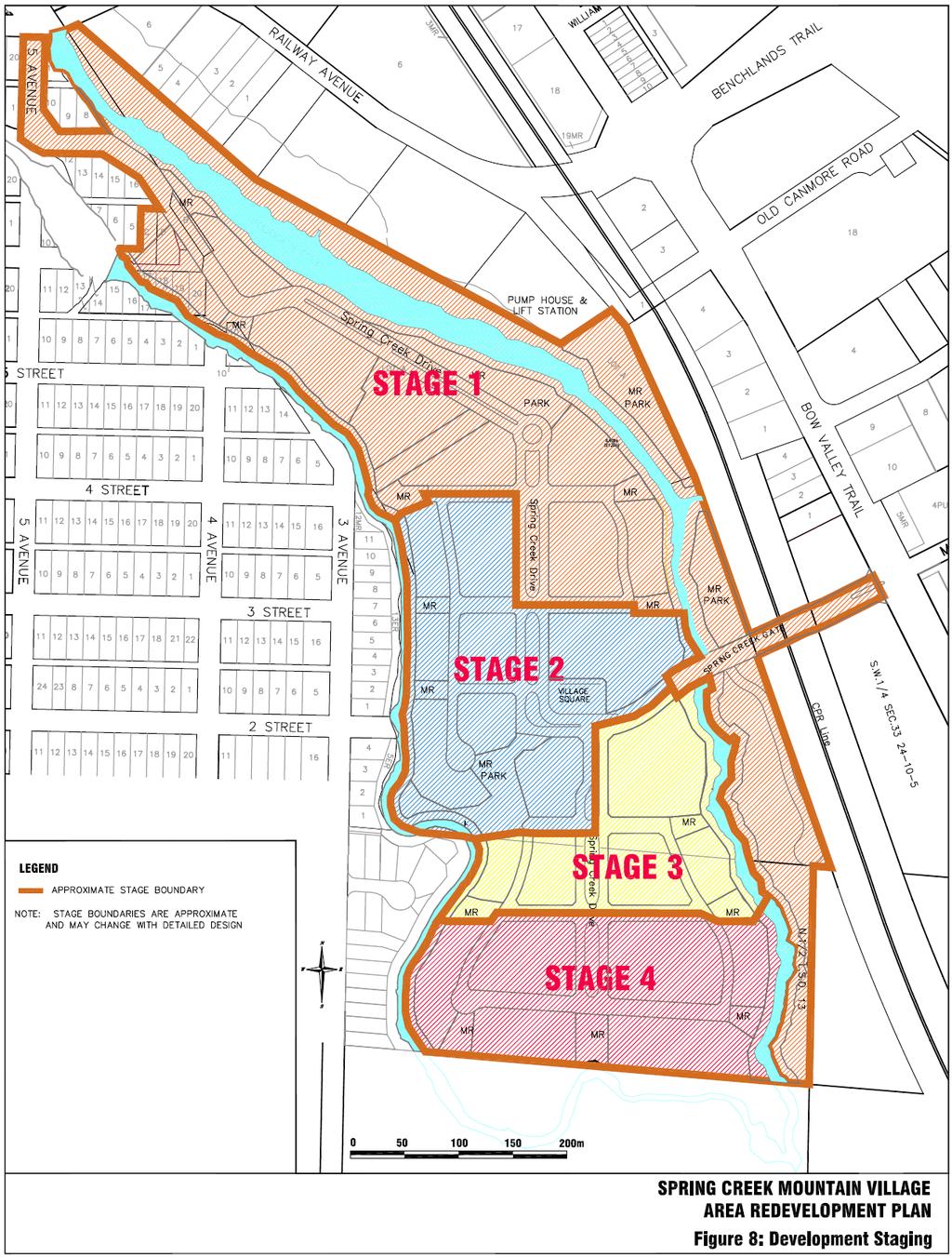
33 4.10 DEVELOPMENT STAGING The development staging policies are designed to permit a logical sequence of development. Staging considerations include transportation and access requirements, utility infrastructure and the relocation and replacement over time of existing mobile homes and ancillary buildings. Figure 8: Development Staging shows a tentative redevelopment staging plan which may be revised over time depending on final servicing, transportation and construction requirements. Table 4: Development by Stage shows an approximate breakdown of the anticipated residential and commercial development by stage. These numbers may change depending on market conditions Development Staging: The development will occur in four main stages generally as shown on Figure 8. The stage boundaries are considered approximate and may be revised as development proceeds without the need for a formal revision to the ARP. Each stage may contain several development phases Direction of Growth: The staging sequence shall generally be from north to south. However, some relocation of homes in the central portion of the site may be advanced to permit construction and utilization of the new road access from Bow Valley Trail New Access Road: A new vehicular and emergency access from Bow Valley Trail to the Plan area shall be included with Stage Age of Housing: The newer mobile home housing stock located in the south west portion of the site shall be retained until the last stage of redevelopment Housing Replacement: The staging sequence shall ensure that the proportion of PAH housing provided in each stage is consistent with a minimum of 5% PAH housing at build-out Infrastructure: New development shall be serviced by connection to Town-owned infrastructure. Private water and sewer systems will be phased out and eventually eliminated. Utility upgrading and phasing shall be coordinated with the Town Open Space and Trail System: Open space, trails and creek bank rehabilitation shall be completed for each stage within 2 years of completion of the subdivision Servicing Agreement Construction Timing: Creek bank rehabilitation and some portions of the trail system may be advanced where practical. 31

34 Growth Management: The rate of growth within Spring Creek Mountain Village will be controlled by establishing minimum time frames for each development stage approval. This will be implemented through establishing a not before date for land use amendments in the Land Use Bylaw and is based on a maximum 80 units per year average TABLE 4: ESTIMATED DEVELOPMENT BY STAGE 32
35 33
36 4.11 PLAN IMPLEMENTATION The following policies provide the framework for implementation of the Area Redevelopment Plan Municipal Development Plan Amendment (MDP): An amendment to the MDP will be required to allow visitor accommodation and other commercial components of the ARP to be incorporated. This amendment should be processed concurrently with the adoption of this Area Redevelopment Plan Special Land Use District: A Spring Creek Mountain Village Land Use District will be prepared by the developer in consultation with Town. This bylaw will be submitted to Council for approval and inclusion into the Town of Canmore Land Use Bylaw Land Use Redesignation: Land Use Redesignation will be required prior to further subdivision and redevelopment in the study area Subdivision Process: The normal Town of Canmore process of subdivision application and approval procedures shall be required for further subdivision of land and the creation of any new titles within the ARP area Permits: The normal Town of Canmore Development Permit process of application and approvals shall be required prior to the commencement of any development within the approved ARP Interim use of Proposed MR and ER lands: At the time of subdivision, some deferral of registration for Environmental Reserve or Municipal Reserve parcels will be considered by the Town in order to allow present uses to continue until such time as they are required for redevelopment. 34
SCMV ARP LANDS SUSTAINABILITY SCREENING REPORT
 SCMV ARP LANDS SUSTAINABILITY SCREENING REPORT SPRING CREEK MOUNTAIN VILLAGE SEPTEMBER 26, 2009 SUSTAINABILITY SCREENING REPORT SCMV ARP LANDS SEPTEMBER 2009 Submitted for: Spring Creek Mountain Village
Bylaw No. B-03/2011 Adopted by Airdrie City Council February 21, 2012
 COOPER S CROSSING STAGE 4 Neighbourhood Structure Plan City of Airdrie WESTMARK HOLDINGS LTD. Bylaw No. B-03/2011 Adopted by Airdrie City Council February 21, 2012 CONSULTANTS: LAND USE PLANNING: Southwell
Land Use Amendment in Southwood (Ward 11) at and Elbow Drive SW, LOC
 at and Elbow Drive SW, LOC") 2018 November 15 Page 1 of 10 EXECUTIVE SUMMARY This land use amendment application was submitted by Rick Balbi Architect on 2017 August 31 on behalf of Sable Developments Ltd, and with authorization from
2018 November 15 Page 1 of 10 EXECUTIVE SUMMARY This land use amendment application was submitted by Rick Balbi Architect on 2017 August 31 on behalf of Sable Developments Ltd, and with authorization from
City of Grande Prairie Development Services Department
 City of Grande Prairie Development Services Department ROYAL OAKS NORTH OUTLINE PLAN OP-07-03 NW 35-71-6 W6M May 7, 2007 Royal Oaks North Outline Plan TABLE OF CONTENTS 1.0 INTRODUCTION........ 3 1.1 Purpose
OP Council Resolution June 16, Planning and Development Services
 OP-08-01 Council Resolution June 16, 2008 Planning and Development Services Kingsgate Landing Outline Plan Table of Contents 1.0 Introduction 1 1.1 Purpose of Plan 1 1.2 Plan Area Location 1 1.3 Ownership
ROAD CLOSURE AND LAND USE AMENDMENT SILVER SPRINGS (WARD 1) NORTHEAST OF NOSEHILL DRIVE NW AND SILVER SPRINGS ROAD NW BYLAWS 2C2018 AND 29D2018
 NORTHEAST OF NOSEHILL DRIVE NW AND SILVER SPRINGS ROAD NW BYLAWS 2C2018 AND 29D2018") Page 1 of 19 EXECUTIVE SUMMARY This application proposes redesignating two parcels in the community of Silver Springs from Special Purpose Future Urban Development (S-FUD) District and undesignated road
Page 1 of 19 EXECUTIVE SUMMARY This application proposes redesignating two parcels in the community of Silver Springs from Special Purpose Future Urban Development (S-FUD) District and undesignated road
Westwind Developments Ltd. PIONEER LANDS AREA STRUCTURE PLAN - PROPOSED AMENDMENT
 FEBRUARY 2013 TABLE OF CONTENTS 1.0 BACKGROUND... 1 1.1 Amendment... 1 2.0 LOCATION & CONTEXT... 2 2.1 Land Ownership... 2 3.0 POLICY CONTEXT... 3 3.1 Municipal Development Plan... 3 3.2 Capital Region
City of Grande Prairie Development Services Department KENNEDY DEVELOPMENTS LTD. OUTLINE PLAN OP-09-01
 City of Grande Prairie Development Services Department KENNEDY DEVELOPMENTS LTD. OUTLINE PLAN OP-09-01 July 27, 2009 TABLE OF CONTENTS 1.0 Introduction... 1 1.1 Plan Area Location & Context... 1 1.2 Ownership
Outline Plan in Belvedere (Ward 9) at Street SE, LOC (OP)
 at Street SE, LOC (OP)") 2018 October 04 Page 1 of 12 EXECUTIVE SUMMARY This outline plan application was submitted by B&A Planning Group on 2016 July 15, on behalf of Tristar Communities Inc. for 50.14 hectares (123.89 acres)
2018 October 04 Page 1 of 12 EXECUTIVE SUMMARY This outline plan application was submitted by B&A Planning Group on 2016 July 15, on behalf of Tristar Communities Inc. for 50.14 hectares (123.89 acres)
FORMER CANADIAN FORCES BASE (CFB) ROCKCLIFFE SECONDARY PLAN. Official Plan Amendment XX to the Official Plan for the City of Ottawa
 ROCKCLIFFE SECONDARY PLAN. Official Plan Amendment XX to the Official Plan for the City of Ottawa") FORMER CANADIAN FORCES BASE (CFB) ROCKCLIFFE SECONDARY PLAN Official Plan Amendment XX to the Official Plan for the City of Ottawa 1 INDEX THE STATEMENT OF COMPONENTS PART A THE PREAMBLE PAGE Purpose...
FORMER CANADIAN FORCES BASE (CFB) ROCKCLIFFE SECONDARY PLAN Official Plan Amendment XX to the Official Plan for the City of Ottawa 1 INDEX THE STATEMENT OF COMPONENTS PART A THE PREAMBLE PAGE Purpose...
LAND USE AMENDMENT CORNERSTONE (WARD 3) 60 STREET NE AND COUNTRY HILLS BOULEVARD NE MAP 26NE BYLAW 22D2017
 60 STREET NE AND COUNTRY HILLS BOULEVARD NE MAP 26NE BYLAW 22D2017") Page 1 of 14 EXECUTIVE SUMMARY This Land Use Amendment application covers an area of 43.76 hectares ± (108.14 acres ±) located in northeast Calgary, bound by Country Hills Boulevard NE to the south and
Page 1 of 14 EXECUTIVE SUMMARY This Land Use Amendment application covers an area of 43.76 hectares ± (108.14 acres ±) located in northeast Calgary, bound by Country Hills Boulevard NE to the south and
This application has been applied for with support of an Outline Plan to provide the technical details for the site s development.
 Page 1 of 13 EXECUTIVE SUMMARY This application consists of a Land Use Amendment application proposing redesignation from Special Purpose Future Urban Development (S-FUD) District to an assortment of multiresidential,
North Oakville East Parks Facilities Distribution Plan. November, 2009
 North Oakville East November, 2009 POLICY CONTEXT 1) Purpose a) The purpose of this document is to be a guide for the location, configuration, design and development of the parks system for the North Oakville
ADMINISTRATION RECOMMENDATION(S) 2018 January 25. That Calgary Planning Commission recommend APPROVAL of the proposed Land Use Amendment.
 2018 January 25. That Calgary Planning Commission recommend APPROVAL of the proposed Land Use Amendment.") Page 1 of 9 EXECUTIVE SUMMARY This land use amendment proposes to redesignate a parcel from DC Direct Control District to Multi-Residential Contextual Grade-Oriented (M-CG) District to allow for multi-residential
Page 1 of 9 EXECUTIVE SUMMARY This land use amendment proposes to redesignate a parcel from DC Direct Control District to Multi-Residential Contextual Grade-Oriented (M-CG) District to allow for multi-residential
CONTENTS 8.0 LAND USE 8.1 GENERAL LAND USE 8.2 RESIDENTIAL 8.3 MIXED USE 8.4 COMMERCIAL 8.5 EMPLOYMENT LANDS
 8-2 Land Use 8.0 LAND USE CONTENTS 8.1 GENERAL LAND USE 8.1.1 Uses provided for in all Land Use Designations 8.1.2 Uses prohibited in Hazardous Lands, Hazardous Sites and Special Policy Areas 8.1.3 Uses
GATEWAY AREA STRUCTURE PLAN
 CHESTERMERE GATEWAY AREA STRUCTURE PLAN COMMUNITY OPEN HOUSE SEPTEMBER 22 nd, 2015 PLAN AREA ± 512 hectares (± 1,265 acres) GATEWAY LOCATION UNDEVELOPED LANDS PRESENT AGRICULTURAL USE REGIONAL LAND USE
ARTICLE 6: Special and Planned Development Districts
 ARTICLE 6: Special and Planned Development Districts 6-10 Traditional Neighborhood Development (TND) District 6-10.10 Purpose and Intent The Traditional Neighborhood Development (TND) District provides
[PLANNING RATIONALE] For Site Plan Control and Lifting of Holding Zone By-Law 101 Champagne Avenue. May 23, 2014
![[PLANNING RATIONALE] For Site Plan Control and Lifting of Holding Zone By-Law 101 Champagne Avenue. May 23, 2014](/thumbs/75/71599615.jpg "[PLANNING RATIONALE] For Site Plan Control and Lifting of Holding Zone By-Law 101 Champagne Avenue. May 23, 2014") [PLANNING RATIONALE] For Site Plan Control and Lifting of Holding Zone By-Law 101 Champagne Avenue May 23, 2014 Contents 1.0 Introduction... 2 2.0 Site Context... 2 2.1 Adjacent Uses... 2 Figure 1: Site
[PLANNING RATIONALE] For Site Plan Control and Lifting of Holding Zone By-Law 101 Champagne Avenue May 23, 2014 Contents 1.0 Introduction... 2 2.0 Site Context... 2 2.1 Adjacent Uses... 2 Figure 1: Site
and services The protection and conservation of environmentally significant and sensitive natural heritage features and functions.
 6. Land Use 6.0 Preamble A healthy and livable city is one in which people can enjoy a vibrant economy and a sustainable healthy environment in safe, caring and diverse neighbourhoods. In order to ensure
The transportation system in a community is an
 7 TRANSPORTATION The transportation system in a community is an important factor contributing to the quality of life of the residents. Without a sound transportation system to bring both goods and patrons
LAND USE AMENDMENT DOWNTOWN COMMERCIAL CORE (WARD 7) MACLEOD TRAIL SE AND 5 AVENUE SE BYLAW 254D2017
 MACLEOD TRAIL SE AND 5 AVENUE SE BYLAW 254D2017") Page 1 of 10 EXECUTIVE SUMMARY This Land Use Amendment application seeks to redesignate a full downtown block (currently the YWCA site) from a Direct Control based on the CM-2 District (Land Use Bylaw
Page 1 of 10 EXECUTIVE SUMMARY This Land Use Amendment application seeks to redesignate a full downtown block (currently the YWCA site) from a Direct Control based on the CM-2 District (Land Use Bylaw
6 PORT SYDNEY SETTLEMENT AREA
 Section 6 Port Sydney Page 61 6 PORT SYDNEY SETTLEMENT AREA 6.1 Basis and Principles Village of Port Sydney Waterfront Community Existing Services 6.1.1 Port Sydney is an historic settlement that has developed
Welcome. Walk Around. Talk to Us. Write Down Your Comments
 Welcome This is an information meeting introducing the applications for proposed redevelopment of the Yorkdale Shopping Centre site at 3401 Dufferin Street and 1 Yorkdale Road over the next 20+ years,
URBAN DESIGN BRIEF. 2136&2148 Trafalgar Road. Town of Oakville
 URBAN DESIGN BRIEF 2136&2148 Trafalgar Road Town of Oakville Prepared By: METROPOLITAN CONSULTING INC For 2500674 Ontario Inc November 2016 TABLE OF CONTENTS Page No. 1.0 Introduction/Description of Subject
THE CORPORATION OF THE TOWN OF OAKVILLE BY-LAW NUMBER
 THE CORPORATION OF THE TOWN OF OAKVILLE BY-LAW NUMBER 20012-08530 A by-law to adopt an amendment to the Official Plan of the Oakville Planning Area (Official Plan Amendment 198) Land North of Dundas Street.
EXISTING COMPREHENSIVE PLAN
 EXISTING COMPREHENSIVE PLAN Town Center Land Use Element: V. LAND USE POLICIES Town Center Mercer Island's business district vision as described in "Your Mercer Island Citizen-Designed Downtown" was an
Appendix C: Interim Mixed-Use Evaluation Criteria
 Appendix C: Interim Mixed-Use Evaluation Criteria C-1 Appendix C: Interim Mixed-Use Evaluation Criteria PURPOSE: The implementation of numerous policies contained within the Master Plan hinges on the creation
ADMINISTRATION RECOMMENDATION 2016 November 03. That Calgary Planning Commission recommends APPROVAL of the proposed Land Use Amendment.
 Page 1 of 12 EXECUTIVE SUMMARY This Land Use Amendment application covers an area of 75.76 hectares ± (187.20 acres ±) located in northeast Calgary, bound by Stoney Trail NE to the north, 128 Avenue NE
March 21, 2018 ALCA Meeting. March 21, 2018
 March 21, 2018 ALCA Meeting March 21, 2018 Agenda 1. Process and Timeline 2. Original Submission 3. Revised Submission 4. Next Steps The City of Calgary Role: The City is responsible for capturing and
URBAN DESIGN BRIEF URBAN DESIGN BRIEF 721 FRANKLIN BLVD, CAMBRIDGE August 2018
 URBAN DESIGN BRIEF URBAN DESIGN BRIEF 721 FRANKLIN BLVD, CAMBRIDGE August 2018 DESIGN BRIEF CONTENTS PART A 1.0 INTRODUCTION 2.0 DESCRIPTION & ANALYSIS OF SITE CONTEXT 3.0 DESIGN CONSTRAINTS AND OPPORTUNITIES
PORT WHITBY COMMUNITY
 PORT WHITBY COMMUNITY SECONDARY PLAN UPDATE COMMUNITY IMPROVEMENT PLAN URBAN DESIGN GUIDELINES September 2015 DRAFT PROPOSED AMENDMENT NUMBER # to the Whitby Official Plan PURPOSE: The intent of this Amendment
HAMLET OF KINGMAN AREA STRUCTURE PLAN
 HAMLET OF KINGMAN AREA STRUCTURE PLAN Prepared by: Austrom Consulting Ltd. Page 1 of 19 Table of Contents TABLE OF CONTENTS... 2 1. BACKGROUND... 3 1.1 PLAN AREA... 3 1.2 PLAN PURPOSE... 3 1.3 LEGISLATIVE
C ity of Grande Prairie Development Services Department
 C ity of Grande Prairie Development Services Department FAIRWAY DEVELOPMENT OUTLINE PLAN OP 08 09 Approved April 6, 2009 Prepared by: Focus Corporation Table of Contents 1.0. Introduction 2 3 1.1. Plan
Mark-up of the effect of the proposed Bronte Village Growth Area OPA No.18 on the text of section 24, Bronte Village, of the Livable Oakville Plan
 Mark-up of the effect of the proposed Bronte Village Growth Area OPA No.18 on the text of section 24, Bronte Village, of the Livable Oakville Plan Notes: This document is provided for information purposes
POLICY AMENDMENT AND LAND USE AMENDMENT KILLARNEY/GLENGARRY (WARD 8) NW CORNER OF RICHMOND ROAD AND 33 STREET SW BYLAWS 1P2015 AND 7D2015
 NW CORNER OF RICHMOND ROAD AND 33 STREET SW BYLAWS 1P2015 AND 7D2015") Page 1 of 13 EXECUTIVE SUMMARY This application seeks to redesignate an RC-2 (Residential Contextual One/Two Dwelling) parcel to MC-Gd72 (Multi-Residential Contextual Grade-Oriented) to allow for multi-residential
Page 1 of 13 EXECUTIVE SUMMARY This application seeks to redesignate an RC-2 (Residential Contextual One/Two Dwelling) parcel to MC-Gd72 (Multi-Residential Contextual Grade-Oriented) to allow for multi-residential
Urban Design Manual PLANNING AROUND RAPID TRANSIT STATIONS (PARTS) Introduction. Station Study Areas
 Introduction. Station Study Areas") 111111 PLANNING AROUND RAPID TRANSIT STATIONS (PARTS) Introduction The ION rapid transit system will link Waterloo, Kitchener and Cambridge through a central transit corridor (CTC). There are a number
111111 PLANNING AROUND RAPID TRANSIT STATIONS (PARTS) Introduction The ION rapid transit system will link Waterloo, Kitchener and Cambridge through a central transit corridor (CTC). There are a number
Town Center (part of the Comprehensive Plan)
") Town Center (part of the Comprehensive Plan) Mercer Island Town Center Looking North (2014) In 1994, a year-long process culminated in a set of design guidelines and code requirements for the Town Center
Town Center (part of the Comprehensive Plan) Mercer Island Town Center Looking North (2014) In 1994, a year-long process culminated in a set of design guidelines and code requirements for the Town Center
A. WHAT IS A GENERAL PLAN?
 I. Introduction A. WHAT IS A GENERAL PLAN? A general plan is the planning guideline for the future of a city. It contains goals and policies which regulate urban development, the protection of the natural
BYLAW C A Bylaw of Rocky View County to amend Land Use Bylaw C
 BYLAW C-7720-2017 A Bylaw of Rocky View County to amend Land Use Bylaw C-4841-97. The Council of Rocky View County enacts as follows: PART 1 TITLE This Bylaw shall be known as Bylaw C-7720-2017. PART 2
PUBLIC OPEN HOUSE SEPTEMBER 8 TH, 2010 CITY OF LETHBRIDGE DEVELOPMENT SERVICES
 PUBLIC OPEN HOUSE SEPTEMBER 8 TH, 2010 CITY OF LETHBRIDGE DEVELOPMENT SERVICES INTRODUCTION Why is the City creating the West Lethbridge Employment Centre Area Structure Plan? West Lethbridge Urbanization
Mill Woods Town Centre Proposed Rezoning LDA
 Mill Woods Town Centre Proposed Rezoning LDA15 0649 The City of Edmonton has received an application for rezoning and an amendment to the Mill Woods Station Area Redevelopment Plan (ARP) for the Mill Woods
1.0 Purpose of a Secondary Plan for the Masonville Transit Village
 Report to Planning and Environment Committee To: Chair and Members Planning & Environment Committee From: John M. Fleming Managing Director, Planning and City Planner Subject: Masonville Transit Village
EXHIBIT A. Tax Increment Reinvestment Zone No. 1 (Town Center) First Amended Project Plan 1
 First Amended Project Plan 1") EXHIBIT A Tax Increment Reinvestment Zone No. 1 (Town Center) First Amended Project Plan 1 1 As amended by Resolution No. 2008-02-001(TR1R) of the Tax Increment Reinvestment Zone No.1, and approved to
EXHIBIT A Tax Increment Reinvestment Zone No. 1 (Town Center) First Amended Project Plan 1 1 As amended by Resolution No. 2008-02-001(TR1R) of the Tax Increment Reinvestment Zone No.1, and approved to
Gold Line Bus Rapid Transit Transit Oriented Development (BRTOD) Helmo Station Area Plan
 Helmo Station Area Plan") Appendix F Gold Line Bus Rapid Transit Transit Oriented Development (BRTOD) Helmo Station Area Plan Introduction and Purpose of the Plan The Gold Line Bus Rapid Transit facility is an eleven-mile dedicated
Appendix F Gold Line Bus Rapid Transit Transit Oriented Development (BRTOD) Helmo Station Area Plan Introduction and Purpose of the Plan The Gold Line Bus Rapid Transit facility is an eleven-mile dedicated
APPLICATION BRIEFING Prepared For: Submitted by: Date: Subject:
 Planning & Development APPLICATION BRIEFING Prepared For: Submitted by: Date: Subject: Planning Advisory Committee Jason Fox, Director of Planning & Development Development Agreement application by Godfrey
Queen Street West - Zoning Amendment Application - Preliminary Report
 STAFF REPORT ACTION REQUIRED 944-952 Queen Street West - Zoning Amendment Application - Preliminary Report Date: February 6, 2013 To: From: Wards: Reference Number: Toronto and East York Community Council
DAVENPORT VILLAGE SECONDARY PLAN
 27 DAVENPORT VILLAGE SECONDARY PLAN 27. DAVENPORT VILLAGE SECONDARY PLAN 1. VISION FOR THE DAVENPORT VILLAGE SECONDARY PLAN Davenport Village, municipally known as 830, 940, 980 and 1100 Lansdowne Avenue,
Complete Neighbourhood Guidelines Review Tool
 Complete Neighbourhood Guidelines Review Tool Prepared By: City of Regina Planning Department October 2014 Page 1 of 14 Community Development Review Checklist for Secondary Plans and Concept Plans The
DOWNTOWN GEORGETOWN PLANNING STUDY
 DOWNTOWN GEORGETOWN PLANNING STUDY Community Workshop #3 Thursday, May 4, 08 The Planning Partnership OVERVIEW OF STUDY, PROCESS & MILESTONES We are here PURPOSE OF THE STUDY To develop a clear vision
The lands identified as Residential Areas on Schedule A1, Urban Structure, represent the areas that provide for stable residential communities.
 Livable Oakville Part D: Land Use Designations and Policies 11. RESIDENTIAL 11.1 General The lands identified as Residential Areas on Schedule A1, Urban Structure, represent the areas that provide for
Figure 1- Site Plan Concept
 Figure 1- Site Plan Concept Parking will be provided underground on three levels at rate of 1.0 space/ unit; this rate includes all visitors parking. MMM Group has prepared a parking assessment (April,
POLICY AMENDMENT AND LAND USE AMENDMENT TUXEDO PARK (WARD 9) CENTRE STREET N AND 26 AVENUE NE BYLAWS 36P2017 AND 234D2017
 CENTRE STREET N AND 26 AVENUE NE BYLAWS 36P2017 AND 234D2017") Page 1 of 11 EXECUTIVE SUMMARY This application proposes to redesignate a single parcel of land in the Community of Tuxedo Park from Commercial Corridor 2 (C-COR2 f1h10) District to Mixed Use Active Frontage
Page 1 of 11 EXECUTIVE SUMMARY This application proposes to redesignate a single parcel of land in the Community of Tuxedo Park from Commercial Corridor 2 (C-COR2 f1h10) District to Mixed Use Active Frontage
PSRC REVIEW REPORT & CERTIFICATION RECOMMENDATION
 PSRC REVIEW REPORT & CERTIFICATION RECOMMENDATION KITSAP COUNTY COUNTYWIDE PLANNING POLICIES July 2, 2012 BACKGROUND A major emphasis of the Washington State Growth Management Act (GMA) is the need to
A Growing Community Rural Settlement Areas
 Town of Huntsville Official Plan Review - POLICY BACKGROUND PAPER A Growing Community Rural Settlement Areas BACKGROUND: In addition to the fully municipally-serviced Urban Settlement Area and the Hidden
SUBJECT: Proposed Downtown Mobility Hub Precinct Plan and Proposed Official Plan Policies
 Page 1 of Report PB-81-17 SUBJECT: Proposed Downtown Mobility Hub Precinct Plan and Proposed Official Plan Policies TO: FROM: Committee of the Whole Planning and Building Department Report Number: PB-81-17
Derry Green Corporate Business Park
 Town of Milton Derry Green Corporate Business Park Urban Design Guidelines BMI/Pace - June 2010 Draft 3 Prepared by: Brook McIlroy Planning + Urban Design / Pace Architects Suite 300-51 Camden Street Toronto,
Policies and Code Intent Sections Related to Town Center
 Policies and Code Intent Sections Related to Town Center The Town Center Vision is scattered throughout the Comprehensive Plan, development code and the 1994 Town Center Plan. What follows are sections
Urban Design Brief. Watson Parkway North & Watson Road North Guelph, Ontario. Prepared by Coletara Development
 Urban Design Brief Watson Parkway North & Watson Road North Guelph, Ontario Prepared by Coletara Development December, 2013 Urban Design Brief, Coletara Development 1 Introduction This Urban Design Brief
150 Eighth Street Zoning By-law Amendment Application Preliminary Report
 REPORT FOR ACTION 150 Eighth Street Zoning By-law Amendment Application Preliminary Report Date: March 27, 2019 To: Etobicoke York Community Council From: Director, Community Planning, Etobicoke York District
5.1 Site Plan Guidelines
 5. Community Core Guidelines Development of the Community Core will take place by plan of subdivision and site plan approval. It will occur in a phased manner that will reflect the timing of residential
CHAPTER 7: Transportation, Mobility and Circulation
 AGLE AREA COMMUNITY Plan CHAPTER 7 CHAPTER 7: Transportation, Mobility and Circulation Transportation, Mobility and Circulation The purpose of the Transportation, Mobility and Circulation Chapter is to
Planning & Development. Background. Subject Lands
 Planning & Development APPLICATION BRIEFING Prepared For: Planning Advisory Committee Submitted by: Jason Fox, Director of Planning & Development Date: Subject: Development Agreement Application by Brentwood
The Corporation of the TOWN OF MILTON
 Report to: From: Chair & Members of the Administration & Planning Standing Committee W.F. Mann, Director of Planning and Development Date: April 16, 2012 PD 022-12 (Z19/11) Subject: Technical Report Proposed
3. VISION AND GOALS. Vision Statement. Goals, Objectives and Policies
 Vision Statement Queen Creek s interconnected network of parks, trails, open spaces and recreation opportunities provide safe and diverse activities and programs that sustain its unique, small town, equestrian
S o u t h C e n t r a l O u t l i n e P l a n. Leduc Business Park. North Leduc Industrial Area Structure Plan C it y of Led u c.
 Leduc Business Park North Leduc Industrial Area Structure Plan C it y of Led u c Prepared for Farm Air Properties Inc. January, 2007 Table of Contents Page Number 1.0 Purpose of Plan and Definition of
178 Carruthers Properties Inc.
 178 Carruthers Properties Inc. Planning Rationale for 178 Carruthers Avenue Site Plan Control Application June 2014 Table of Contents 1.0 Introduction 2.0 Overview of Subject Property 3.0 Current Zoning
LAND USE AMENDMENT CORNERSTONE (WARD 3) COUNTRY HILLS BOULEVARD AND STONEY TRAIL NE BYLAW 9D2017
 COUNTRY HILLS BOULEVARD AND STONEY TRAIL NE BYLAW 9D2017") Page 1 of 12 EXECUTIVE SUMMARY This Land Use Amendment application covers an area of 54.92 hectares ± (135.71 acres ±) located in northeast Calgary, bound by Country Hills Boulevard NE to the north and
Page 1 of 12 EXECUTIVE SUMMARY This Land Use Amendment application covers an area of 54.92 hectares ± (135.71 acres ±) located in northeast Calgary, bound by Country Hills Boulevard NE to the north and
HURON COMMUNITY PLAN
 CITY OF KITCHENER DEPARTMENT OF DEVELOPMENT AND TECHNICAL SERVICES PD 94/7 HURON COMMUNITY PLAN Recommended by Planning and Economic Development Committee: October 31, 1994 Adopted by Kitchener City Council:
4780 Eglinton Avenue West - Zoning By-law Amendment and Draft Plan of Subdivision Applications - Preliminary Report
 STAFF REPORT ACTION REQUIRED 4780 Eglinton Avenue West - Zoning By-law Amendment and Draft Plan of Subdivision Applications - Preliminary Report Date: May 29, 2014 To: From: Wards: Reference Number: Etobicoke
WEST HILL BUSINESS PARK AREA STRUCTURE PLAN
 MUNICIPAL DISTRICT OF PEACE NO. 135 WEST HILL BUSINESS PARK AREA STRUCTURE PLAN Prepared by: TABLE OF CONTENTS 1.0 Introduction... 1 1.1 Purpose of Plan........ 1 1.2 Plan Area..... 1 1.3 Existing Conditions...
Bloor St. W. Rezoning - Preliminary Report
 STAFF REPORT ACTION REQUIRED 1638-1644 Bloor St. W. Rezoning - Preliminary Report Date: April 1, 2008 To: From: Wards: Reference Number: Toronto and East York Community Council Acting Director, Community
YONGE STEELES CORRIDOR SECONDARY PLAN. Young + Wright / IBI Group Architects Dillon Consulting Ltd. GHK International (Canada) Ltd.
 Ltd.") PART A: PREAMBLE 1.0 PURPOSE The purpose of this Secondary Plan is to provide a development framework for intensification of the Yonge/ Steeles corridor including the north side of Steeles Avenue West
PART A: PREAMBLE 1.0 PURPOSE The purpose of this Secondary Plan is to provide a development framework for intensification of the Yonge/ Steeles corridor including the north side of Steeles Avenue West
Planning and Growth Management Committee. Chief Planner and Executive Director, City Planning Division. Pg12013 (File No NNY 34 OZ)
") 865 York Mills Road Official Plan Amendment Application Preliminary Report STAFF REPORT ACTION REQUIRED Date: February 28, 2012 To: From: Wards: Reference Number: Planning and Growth Management Committee
865 York Mills Road Official Plan Amendment Application Preliminary Report STAFF REPORT ACTION REQUIRED Date: February 28, 2012 To: From: Wards: Reference Number: Planning and Growth Management Committee
13 THORNHILL YONGE STREET STUDY IMPLEMENTATION CITY OF VAUGHAN OPA 669 AND TOWN OF MARKHAM OPA 154
 13 THORNHILL YONGE STREET STUDY IMPLEMENTATION CITY OF VAUGHAN OPA 669 AND TOWN OF MARKHAM OPA 154 The Planning and Economic Development Committee recommends the adoption of the recommendations contained
Regency Developments. Urban Design Brief. Holyrood DC2 Rezoning
 Regency Developments Urban Design Brief Holyrood DC2 Rezoning Stantec Consulting Ltd. 7-31-2017 1. Overview Regency Developments intends to rezone the lands located at 8510 and 8511 93 Avenue, within the
The Uplands Area Structure Plan. City of Cold Lake, NE & SE W4
 City of Cold Lake, NE & SE 13-63-2-W4 July 2009 1 Contents 1 Background information... 1 1.1 Foreword... 1 1.2 Purpose... 1 1.3 Plan Area and Location... 1 1.4 Ownership... 2 2 Factors Influencing Development...
SECTION 7A: WHAKARONGO RESIDENTIAL AREA
 SECTION 7A: WHAKARONGO RESIDENTIAL AREA CONTENTS 7A.1 Introduction 1 7A.2 Resource Management Issues 1 7A.3 Objectives and Policies 1 7A.4 Methods 4 7A.5 Residential Zone 4 7A.5.1 Rules: Controlled Activities
RECREATION AND OPEN SPACE ELEMENT GOALS, OBJECTIVES, AND POLICIES
 RECREATION AND OPEN SPACE ELEMENT GOALS, OBJECTIVES, AND POLICIES Goal 7 To provide park facilities, recreation programs, and open space resources that are safe, adequate, and accessible to all City residents,
Red Fox Commercial Outline Plan
 Red Fox Commercial Outline Plan City of Cold Lake, Alberta Prepared by Durrance Projects Ltd and Ross W. Sharp & Associates Ltd October 2014 Rupert 1 Table of Contents 1. PURPOSE...3 1.1. Location...4
This Review Is Divided Into Two Phases:
 Semiahmoo Town Centre Review The purpose of this review: To review the Semiahmoo Town Centre Concept Plan, originally approved in 1993, to ensure that this centre will continue to serve the needs of South
S A C R A M E N T O C O U N T Y JACKSON HIGHWAY & GRANT LINE EAST VISIONING STUDY
 JACKSON HIGHWAY & GRANT LINE EAST S A C R A M E N T O C O U N T Y P L A N N I N G D E P A R T M E N T SUMMARY AND WORKBOOK November 19, 2008 History of the Visioning Study Sacramento County has two growth
Chappelle Neighbourhood Area Structure Plan
 Chappelle Neighbourhood Area Structure Plan Office Consolidation September 2017 Prepared by: City Planning Urban Form and Corporate Strategic Development City of Edmonton Bylaw 14779 was adopted by Council
4 RESIDENTIAL ZONE. 4.1 Background
 4 RESIDENTIAL ZONE 4.1 Background The residential areas within the City are characterised by mainly lowrise dwellings sited on individual allotments. Past architectural styles, settlement patterns and
Future Land Use SAMPLE RECOMMENDATIONS
 SAMPLE RECOMMENDATIONS Future Land Use The Future Land Use Chapter of the Master Plan builds upon prior chapters examining the existing conditions in their respective topic areas to present a comprehensive
Description of Preferred Alternative
 Chapter 2 Description of Preferred Alternative 2.1 Introduction This chapter of the programmatic Sammamish Town Center Sub-area Plan Final EIS provides a more detailed description of the Preferred Alternative
AWH REPORT OF THE PLANNING AND DEVELOPMENT DEPARTMENT FOR APPLICATION FOR REZONING ORDINANCE TO PLANNED UNIT DEVELOPMENT
 AWH REPORT OF THE PLANNING AND DEVELOPMENT DEPARTMENT FOR APPLICATION FOR REZONING ORDINANCE TO PLANNED UNIT DEVELOPMENT MAY 8, 2014 The Planning and Development Department hereby forwards to the Planning
McCowan Precinct Plan Study Background & Deliverables
 1 DRAFT & WITHOUT PREJUDICE McCowan Precinct Plan Study Background & Deliverables In September, 2011, City Planning (Scarborough District) began a study of an area within the Scarborough Centre, identified
Municipal Development Plan Update Urban Service Area and Hamlets
 ENCLOSURE 1 Municipal Development Plan Update Urban Service Area and Hamlets Priorities Committee January 24, 2017 MUNICIPAL DEVELOPMENT PLAN UPDATE SHAPING OUR FUTURE MDP Update - Agenda MDP Update Public
Welcome to the Oakridge Centre Open House
 Welcome to the Oakridge Centre Open House Why is the City hosting this event? This open house is to inform you of a rezoning application submitted to the City of Vancouver to amend the existing CD-1 (Comprehensive
1296 Kennedy Road - Zoning Amendment Application - Preliminary Report
 STAFF REPORT ACTION REQUIRED 1296 Kennedy Road - Zoning Amendment Application - Preliminary Report Date: January 15, 2016 To: From: Wards: Reference Number: Scarborough Community Council Acting Director,
DRAFT Northeast Quadrant of Kipling Avenue and Highway 7 DRAFT AUGUST 29, Goals Land Use. The goals of this Plan are to:
 AUGUST 29, 2017 12.15 Northeast Quadrant of Kipling Avenue and Highway 7 12.15.1 Goals 12.15.2 Land Use The goals of this Plan are to: 12.15.2.1 General Provisions: a) Ensure the development of a compact
City of Langford Green Development Checklist
 City of Langford Green Development Checklist The following Green Development Checklist creates a sustainability standard for all comprehensive development within the City of Langford. The commitments made
8 Oak Street - Official Plan and Zoning By-law Amendment Application - Preliminary Report
 STAFF REPORT ACTION REQUIRED 8 Oak Street - Official Plan and Zoning By-law Amendment Application - Preliminary Report Date: March 17, 2014 To: From: Wards: Reference Number: Planning and Growth Management
Mitchell Ranch South MPUD Application for Master Planned Unit Development Approval Project Narrative. Introduction
 Mitchell Ranch South MPUD Application for Master Planned Unit Development Approval Project Narrative Introduction Mitchell Ranch South is a proposed single family (detached) residential development on
6.0 Land Use Policies for Rural Settlements. 6.1 Rural Settlement Strategy
 6.0 Land Use Policies for Rural Settlements 6.1 Rural Settlement Strategy INTRODUCTION AMENDMENT NO. 131 PURPOSE Designated rural settlements comprise Rural Clusters, Villages and Serviced Villages as
4.1.3 LAND USE CATEGORIES
 4.1.3 LAND USE CATEGORIES a. City Center District The City Center District incorporates the existing character and mix of uses in downtown Belmont to encourage redevelopment and new development in keeping
THE CITY OF SPRUCE GROVE BYLAW C PIONEER LANDS AREA STRUCTURE PLAN AMENDMENT
 THE CITY OF SPRUCE GROVE BYLAW C-797-11 PIONEER LANDS AREA STRUCTURE PLAN AMENDMENT WHEREAS, pursuant to the Municipal Government Act, R.S.A., 2000, c.m-26, a municipality shall adopt Area Structure Plans
LAND USE OVERVIEW WHAT YOU WILL FIND IN THIS CHAPTER
 LAND USE WHAT YOU WILL FIND IN THIS CHAPTER Information about the City s expected population and employment growth. Description and capacity of existing and future land use designations. Policies that
OFFICE CONSOLIDATION SECONDARY PLAN AREA 22 THE BRAMALEA SOUTH INDUSTRIAL SECONDARY PLAN
 OFFICE CONSOLIDATION SECONDARY PLAN AREA 22 THE BRAMALEA SOUTH INDUSTRIAL SECONDARY PLAN November 2010 EXPLANATORY NOTES (Secondary Plan Area 22) General (pertaining to all secondary plan office consolidations)
Mill Conversion Overlay District Zoning Bylaw Amendment
 Mill Conversion Overlay District Zoning Bylaw Amendment To see if the Town will vote to amend the Zoning By-Law by adding a new Section 13, Mill Conversion Overlay District, and by amending Sections 2.1,