CottageClub Ghost Lake Conceptual Scheme
|
|
|
- Tracy Clarke
- 6 years ago
- Views:
Transcription

1 CottageClub Ghost Lake Conceptual Scheme Bylaw C , Adopted January 15, 2008 MUNICIPAL DISTRICT OF ROCKY VIEW NO. 44 Department of Planning and Community Services
2 MUNICIPAL DISTRICT OF ROCKY VIEW NO. 44 BYLAW C A Bylaw of the Municipal District of Rocky View No. 44, pursuant to Divisions 7 & 12 of Part 17 of the Municipal Government Act, to adopt the attached Schedule A referred to as the CottageClub Ghost Lake Conceptual Scheme. WHEREAS the Council of the Municipal District of Rocky View No. 44 has received an application to adopt a Conceptual Scheme to establish a comprehensive policy framework to guide and evaluate future redesignation, subdivision and development applications within Lot 1, Block 1, Plan and portions of the N ½ W5M, consisting of an area of approximately ± acres, as shown on Schedule 'A', attached to and forming part of this Bylaw; and WHEREAS the Council deems it desirable to adopt the Conceptual Scheme; and WHEREAS a notice was published on Tuesday, December 4, 2007 and Tuesday, December 11, 2007 in the Rocky View Weekly, a newspaper circulating in the Municipal District of Rocky View No. 44, advising of the Public Hearing for Tuesday, January 15, 2008; and WHEREAS Council held a Public Hearing and have given consideration to the representations made to it in accordance with Section 692 of the Municipal Government Act, being Chapter M- 26 of the Revised Statutes of Alberta, 2000, and all amendments thereto. NOW THEREFORE the Council enacts the following: 1. That the Conceptual Scheme be adopted to provide a comprehensive policy framework to guide and evaluate future redesignation, subdivision and development applications within Lot 1, Block 1, Plan and portions of the N ½ W5M, consisting of an area of approximately ± acres, as shown on Schedule 'A', attached to and forming part of this bylaw; and 2. The Bylaw comes into effect upon the date of its third reading. Division: 9 File: /008/001/002/ RV-405 First reading passed in open Council, assembled in the City of Calgary, in the Province of Alberta, on Tuesday, November 27, 2007, on a motion by Councillor McLean. Second reading passed in open Council, assembled in the City of Calgary, in the Province of Alberta, on Tuesday, January 15, 2008 on a motion by Councillor Louden. Third reading passed in open Council, assembled in the City of Calgary, in the Province of Alberta, on Tuesday, January 15, 2008 on a motion by Councillor McLean. REEVE OR DEPUTY REEVE MUNICIPAL SECRETARY
3 SCHEDULE A FORMING PART OF BYLAW C A Conceptual Scheme affecting the area within the portions of Lot 1, Block 1, Plan and a portion of the N ½ W5M, consisting of approximately ± acres, herein referred to as the CottageClub Ghost Lake Conceptual Scheme area.
4 TABLE OF CONTENTS 1.0 INTRODUCTION PURPOSE AND SCOPE CONCEPTUAL SCHEME OBJECTIVES LAND USE CONTEXT FORM AND CONTENT OF THE CONCEPTUAL SCHEME SITE ANALYSIS Topography and Drainage Subsurface Conditions Existing Structures Vegetation Environmental Considerations Archaeological and Historical COTTAGECLUB GHOST LAKE DEVELOPMENT CONCEPT Vision Objectives Overall Concept Subdivision Design Population Projections Open Space and Municipal Reserve Landscaping Architectural Guidelines TRANSPORTATION Traffic Impact Assessment SERVICING SCENARIO Water and Sanitary Sewer Stormwater Management Private Utilities Solid Waste Management PROTECTIVE SERVICES PROPOSED PHASING PROPOSED LAND USE PUBLIC CONSULTATION STATUTORY PLAN COMPLIANCE Mission Statement and Statement of Goals Plan Philosophy Plan Goals Land Use Strategy Residential Open Space and Recreation INTERMUNICIPAL COOPERATION IMPLEMENTATION Page (i)
5 LIST OF FIGURES Figure 1 Location Plan...2 Figure 2 Conceptual Scheme Planning Area...3 Figure 3 Land Use Context...6 Figure 4 Plan Parts...8 Figure 5 Plan Area Topography...10 Figure 6 Plan Area Contour Intervals...11 Figure 7 Concept Plan...13 Figure 8 Cabin Clusters...15 Figure 9 Open Space and Municipal Reserve...17 Figure 10 Proposed Highway 1A / Range Road 60 Intersection Improvement...21 Figure 11 Stormwater Management...24 Figure 12 Proposed Phasing Plan...26 Page (ii)
6 1.0 INTRODUCTION The Conceptual Scheme Plan Area is located on the western edge of the Municipal District of Rocky View 13 kilometres (8 miles) west of the Town of Cochrane, as shown on Figure 1. The owners of Lot 1, Block 1, Plan initiated the planning process that proposes a 350 unit, recreation based, cottage community. As part of a redesignation application, the Municipality reviewed the request and directed that a Conceptual Scheme be prepared that addressed not only Lot 1, Block 1, Plan , but also a portion of the N½ Section 13, Township 26, Range 6, W5M. The inclusion of this additional land was done in recognition that the two parcels form one planning unit bounded by natural (i.e. rivers) and man-made (i.e. roads and reservoir) features. The boundaries of the CottageClub Ghost Lake Conceptual Scheme are shown on Figure 2, and the legal description and area of each parcel are outlined below: Legal Description Lot 1, Block 1, Plan Part N½ Sec. 13, Twp. 26, Rge. 6, W5M Area ha (79.37 ac) ha (32.94 ac) 1. A baseline description and evaluation of the following matters: natural resources, existing land uses and developments (within and adjacent to the Plan Area), topography, soil types and agricultural capability, vegetation, environmental sensitivities, geotechnical considerations, archaeological and historical considerations, existing utilities and transportation routes. 2. A description of the following matters affecting lands outside the Conceptual Scheme area including analysis of the anticipated impacts development within the Plan Area will have as affecting: the regional transportation network; the regional servicing considerations; the regional socio-economic considerations; and anticipated development impacts on the surrounding agricultural area (including a framework to address the MDP s Land Use Strategy and anticipated development impact on the TransAlta Utilities Inc. infrastructure and operations). 3. A description and evaluation of the following matters describing development within the Conceptual Scheme area: 1.1 Policy: Policies contained within this Conceptual Scheme shall apply to all lands within the Conceptual Scheme Planning Area as shown on Figure 2, Conceptual Scheme Planning Area. 2.0 PURPOSE AND SCOPE The purpose of this Conceptual Scheme is to establish a comprehensive planning framework that will serve as the foundation for future redesignation and subdivision of the Plan Area. It contains a series of policies that provides clear direction on how the Plan Area will develop in the future. The Conceptual Scheme addresses the key elements that will play a role in the successful development of the Plan Area. The elements addressed, as directed by Council on June 22, 2006, include: Page 1 a) b) c) d) the capability of the land to support proposed development of non-agricultural uses and its anticipated infrastructure; local development issues including, but not limited to, geotechnical constraints, environmental constraints, hydrogeological constraints, and archaeological or historically significant features; a strategy to accommodate, mitigate and/or integrate existing development and identification of measures to ensure that the proposed development will not adversely affect the viability of existing uses on adjacent lands; a future development scenario that illustrates comprehensive subdivision design principles that result in an innovative

7 Page 2

8 Page 3
9 e) f) g) h) community, efficient use of the land base, municipal infrastructure, public and private utility systems, and on-site development opportunities; a Biophysical Impact Assessment to inventory and document any environmentally sensitivity within the site with mitigation recommendations that would reduce future development impact on the environment, wildlife and environmentally significant areas; a Utility Servicing Strategy capable of accommodating provision of an appropriate potable water supply and a solid waste system necessary to support the range of uses anticipated within the Conceptual Scheme area, including a strategy to implement water conservation measures with respect to water, wastewater and stormwater management servicing options; a Site Management Plan guided by an adopted Master Drainage Plan that will determine Best Management Practices for stormwater management within the Conceptual Scheme area, including a rationale that demonstrates the Bow River Watershed will not be negatively impacted by proposed development; a Traffic Impact Study that provides for safe and efficient access both within and external to the Conceptual Scheme area, over both the immediate and long term, including the identification of: the existing local and regional transportation network, including existing traffic generation; a description of increased traffic generation resulting from development in the Plan Area (including anticipated impacts on the local and regional transportation network); recommendations for anticipated improvements to existing transportation infrastructure necessary to serve the i) j) k) l) m) n) o) p) q) future land use scenario, including design at full build-out and at each phase of local development; and recommendations for implementation of and financial obligations for all necessary transportation infrastructure improvements; an Open Space and Recreation Plan that provides for comprehensive open space and recreation amenities that include active, passive and natural open space areas and pedestrian linkages both within the Conceptual Scheme area and existing or potential adjacent developments; proposed dedication of lands including, but not limited to, conservation easements, public utility lots, municipal/school reserves; and if necessary, environmental reserves; a scenario to provide for appropriate community service levels including, but not limited to, community policing, fire protection and emergency response; an anticipated tentative plan of subdivision describing the general orientations of the anticipated subdivision design at full build out; a scenario for proposed subdivision and development phasing; anticipated population densities and population projection at full build out and at each anticipated phase of subdivision; mitigation measures such as landscaping treatment, screening and/or berming necessary to address any on- or off-site visual impacts, including site lines from existing adjacent developments; an implementation framework that provides guidance concerning site-specific development controls to be implemented by a Direct Control Bylaw (and Condominium Association Bylaws if required); and input from all directly and indirectly affected landowners within and adjacent Page 4

10 to the Conceptual Scheme area throughout the preparation of the Conceptual Scheme, including a minimum of one open house to encourage the applicant to gather public feedback on the proposal. 4. Identification of development issues (i.e. stormwater management, sewage disposal, onplan area geotechnical features, hydrogeological conditions, proximity and relationship to existing residential development, aesthetics, densities), an assessment of their impact on the surrounding land uses, and establishment of appropriate and comprehensive mitigation measures. 5. A future land use scenario that illustrates efficient and comprehensive development by encouraging innovative subdivision design maximizing lot yields, servicing efficiencies, maximizing onsite development opportunities, accommodates and/or integrates existing development, and recognizes a suitable transition/buffer between new and existing adjacent subdivisions. 6. A description of the proposed internal road hierarchy including its relation to local and regional transportation routes to be determined via preparation of a Traffic Impact Analysis to the satisfaction of the Municipality and Alberta Transportation. 7. A description of a servicing proposal including, but not limited to, public and/or private water, wastewater, stormwater management, and other utilities for the Conceptual Scheme area. 3.0 CONCEPTUAL SCHEME OBJECTIVES The objectives of the Conceptual Scheme are to: a) provide a comprehensive framework and policy direction for future redesignation, subdivision and development of lands contained within the Plan Area shown on Figure 2; b) accommodate future development that is consistent with the historic development in the region; c) provide a recreation based community that takes advantage of its proximity to existing water bodies; and d) recognize the existing hydroelectric facility adjacent to the Plan Area and ensure its ongoing operation. 4.0 LAND USE CONTEXT The Plan Area is isolated from the adjacent lands by the 1A Highway, the Ghost Lake Reservoir, the Bow River, and Range Road 60 (as illustrated on Figure 3). This area to the west has historically accommodated a wide variety of recreational activities centred on the Ghost Lake Reservoir. Although not part of the Plan Area, the Ghost Lake Reservoir is a key feature of the region and has influenced the historic development in the area. It is located at the confluence of the Ghost and Bow Rivers and was formed when the Calgary Power Company (today known as TransAlta ) constructed a dam for the purpose of creating a power generation station. In 1929, the dam was completed and the valley floor was flooded. Creating 8. Identification and description of reserve areas (municipal/school/environmental). 9. Population densities and population projections. 10. Phasing of development. 11. Policies for implementation of the Conceptual Scheme. 12. Any other matter the Municipality deems necessary. Page 5

11 Page 6

12 the reservoir not only provided a source of power, but quickly became a recreational amenity that has and continues to be well used. In the 1950s, a summer village was founded on the north shore of the lake. In addition, two Provincial Campgrounds with beach areas were established adjacent to the Plan Area. Over time, the campgrounds have expanded to include two boat docks, a marina, a store, a restaurant, boat and RV storage, and a boat sales and repair shop. It is also become the home of the Ghost Lake Sailing Club. The areas to the north and east, within the Municipal District of Rocky View, are predominantly vacant with some large acreages (i.e. Agricultural Holdings and Ranch and Farm District). Approximately one mile to the east is a highway business designation that currently accommodates a service station, convenience store and campground. that permits the construction of a boat launch and dock to serve the residents of CottageClub Ghost Lake. Part 3 is owned by This area is to accommodate the recreation based development and has been the subject of extensive analysis and design reviews, as detailed in various reports submitted in conjunction with this Conceptual Scheme Policy: Activities related to the hydroelectric facilities existing uses, including storage of equipment, may continue within the area outlined as Part 1 in Figure 4. These activities predate the current Ranch and Farm Land Use designation and those activities, as well as those permitted by the current land use, may continue Policy: Part 2, as outlined in Figure 4, is to contain a boat launch, dock, and ramp Policy: Part 3, as outlined in Figure 4, may accommodate future development as outlined in subsequent sections of this Conceptual Scheme. 6.0 SITE ANALYSIS 5.0 FORM AND CONTENT OF THE CONCEPTUAL SCHEME The Plan Area has been divided into three parts that recognize existing and proposed uses. Part 1, located adjacent to the Bow River, is owned by TransAlta and is used in conjunction with its hydro generation facility. Through discussions with TransAlta, it recognizes that this area has limited development potential and the need to maintain the area for the ongoing operation of its facilities. Part 2, adjacent to the Ghost Lake Reservoir, is also owned by TransAlta, but is subject to an easement Page 7 The following sets out the site analysis relative to Parts 2 and 3, as illustrated on Figure 4, of the Plan Area. 6.1 Topography and Drainage The Plan Area consists of three areas: Parts 1 and 2 consist of steep slopes that drop down to the Bow River and the Ghost Lake Reservoir below. Part 3 is a large, relatively flat area located above the Bow River and the Ghost Lake Reservoir. Part 3 of the Plan Area topography is relatively flat and it slopes to the southeast with the highest point being 1,210 metres in the northwest corner with the lowest point being 1,206 metres in the SE corner.

13 Page 8

14 Figure 5 illustrates the contours within the Plan Area and Figure 6 illustrates the contour intervals. 6.2 Subsurface Conditions A geotechnical analysis of the Plan Area was completed in The analysis indicated that the Plan Area presents very good conditions for development. Surficial formations include topsoil overlying dry fine to medium grained silty sands which overlies gravel glaciofluvial sediments with cobbles and well rounded boulders below. 6.4 Vegetation A biophysical analysis of the Plan Area was completed. The analysis identified a combination of native and non-native grass species occupy the site. In addition, there is a stand of trees and shrubs located in the northwest corner of the site. Portions of this tree stand will be retained. Portions of the Plan Area contain rough fescue grasslands. The developer will minimize disturbance of not only the fescue grasslands, but the balance of the Plan Area as well. This will be done by restricting grading of the site to internal roadways, location of common area buildings and terracing of the waterfront area. Internal roadways will follow the natural contours of the land. No grading will take place on the cabin lots, rather all cabins will be located on helix piles which create virtually no disturbance of the existing vegetation. Further, the condominium corporation will follow a light footprint, environmentally friendly approach by restricting cabin owners from planting non native vegetation, with hand watering only permitted. 6.5 Environmental Considerations A Phase 1 Environmental Site Assessment was completed in The assessment indicated that: 6.3 Existing Structures There are no existing structures within the Plan Area. As part of the construction of the hydroelectric dam in the 1920s, a gravel pit was excavated to supply material to the dam construction. The 4 hectare (10 acre) pit was subsequently used as a source of gravel. In addition, two gas wells were drilled within the Plan Area, but both proved to be dry holes and have been abandoned. Page 9 there are several registered water wells located in the Plan Area; however, there was no evidence of these wells on-site; contact with the well owners confirmed that the wells were registered incorrectly and are not located in the Plan Area; a small stockpile of soil attributed to historic gas well drilling activities is located in the northeast corner of the Plan Area and is currently undergoing reclamation by Petro Canada; and a gravel pit historically operated in the southeast corner of the Plan Area. Alberta Environment has indicated that a reclamation certificate for the gravel pit will not be required Policy: Prior to subdivision approval, the developer shall provide written confirmation by a professional engineer licensed to practice in the Province of Alberta that either the

15 Page 10

16 Page 11


17 water wells have been abandoned in accordance with Provincial regulations or are located outside the Plan Area Policy: Prior to subdivision approval, the soil stockpile historically associated with petroleum activity has been reclaimed to the satisfaction of the Municipality and Provincial agencies Policy: Prior to subdivision approval, Alberta Environment shall advise either the gravel pit located within the Plan Area has been reclaimed in accordance with Provincial regulations or, alternatively, a reclamation certificate is not required. 6.6 Archaeological and Historical Alberta Community Development was contacted and it advised a Historical Resources Impact Assessment will be required. The assessment has been completed and it notes that the majority of the lands to be developed have been impacted by previous development with the exception of a small wooded area along the western edge of the site. One previously unrecorded site was identified. This site will remain undeveloped and is included in the area designated as open space. At the time of subdivision, a restricted covenant prohibiting any future development will be placed on the historic site Policy: The identified historic site shall be included within the open space system and a restrictive covenant placed on the historic site at the time of subdivision. The restrictive covenant shall prohibit any future development of the historic site unless mitigated measures, satisfactory to the Municipality and Provincial authorities, are undertaken. 7.0 COTTAGECLUB GHOST LAKE DEVELOPMENT CONCEPT CottageClub Ghost Lake is a recreation based community that is to be located at the gateway to the Ghost Lake Reservoir as outlined on Figure 7. This comprehensively planned, family oriented community will cater to families who want an affordable recreation retreat. 7.1 Vision The vision is that: C ottageclub Ghost Lake will be a family oriented recreation based community where children are free to play with their friends in an open, safe and secure environment. Families and friends will meet at the lake to create lifelong memories that will be enjoyed from generation to generation. Owners at CottageClub Ghost Lake will enjoy breathtaking mountain views, private lake access, proximity to the Ghost and Bow Rivers, a trail system, swimming pool, recreation and learning centre, and an abundance of open space to explore. 7.2 Objectives The following sets out the objectives for CottageClub Ghost Lake: To design a community that is sensitive to the land and the surrounding environment through low impact environmentally friendly land development. Page 12
18 Page 13

19 To create a recreation based community that through its design and availability of limited infrastructure discourages permanent occupancy. To provide all key services (i.e. water, sanitary sewer, amenities, maintenance) through a condominium corporation thereby eliminating the need for the Municipality to provide and maintain these services. To create a recreational community that complements the services already available in the area and contributes to strengthening the social and cultural identity of the area. To ensure the highest standard of development by creating architectural guidelines and development standards for all structures built in the community. To create an open space system and facilities that provides residents with a full range of recreational opportunities. To create public amenities that are complementary to those that currently exist in the area. 7.3 Overall Concept CottageClub Ghost Lake is situated in an area that contains recreational activities and facilities. The lands to the west, within the Municipal District of Bighorn, are designated for recreational uses and accommodates marinas, boat launch, provincial campgrounds, and a summer village. This Conceptual Scheme proposes a recreation based community that complements the existing development and contains a variety of cabin forms, a small general store within the recreation and learning centre, a manager s residence at the entrance to the site, open space elements, road network connections, and site servicing. A condominium association will be formed and will be responsible for maintenance, operation and capital expenditures on all common property within the development. Common property will include all internal roads, boat launch, green spaces, pathways, general store, recreation and learning centre and pool, common area washrooms and showers, parks and playgrounds, garbage collection, water treatment and distribution system, and stormwater management. The Conceptual Scheme contemplates that the development be established and regulated through the provisions of a Direct Control Bylaw along Page 14 with condominium bylaws and special regulations, and architectural controls registered through restrictive covenants. 7.4 Subdivision Design The layout of the proposed subdivision is guided by the rectangular shape of the land, the edge conditions associated with the Plan Area and the proposed style of the community. The north portion of the plan borders Highway 1A and provides for an emergency access to Highway 1A in the northwest corner. As Highway 1A is a limited access highway in this region, Range Road 60, which borders the east portion of the Plan Area, will provide the connection to the highway access point. The main collector road within the Plan Area will connect to Range Road 60. The collector road and local streets within CottageClub Ghost Lake shall incorporate design features to avoid long straight segments to reduce traffic speeds, add visual interest and serve to promote traffic calming and safety. The cabins will be detached units, clustered into cells as shown on Figure 8. The cabins will be restricted to a maximum footprint of 600 square feet and a maximum total area of 950 square feet by the Direct Control Bylaw. All of the cabins will be coordinated through the architectural guidelines established and enforced by the developer. A portion of the municipal reserve dedication on the site will be used to provide a public park including a parking lot located at the southeastern edge of the Plan Area. The public will be able to access this area

20 Page 15

21 directly from Range Road 60 and will have pedestrian access to the Bow River via an existing road right-ofway. The potential to construct a stairway down an existing slope to the Bow River is being examined and provided the necessary approvals can be obtained from Municipal, Provincial and Federal authorities, this alternate access would be constructed. The remainder of the municipal reserve dedication will be in the form of cash-in-lieu. Residents of CottageClub Ghost Lake will have access to an extensive open space system that will accommodate various active and passive recreational opportunities. An extensive trail system will provide pedestrian links throughout the community. A recreation and learning centre, catering to CottageClub Ghost Lake residents, will be constructed and will host various community functions and include meeting rooms, a swimming pool, change rooms, and showers Policy: The layout of CottageClub Ghost Lake shall generally be in accordance with Figure Policy: The development shall provide for a variety of single-detached cabins that cater to a variety of recreational lifestyle options Policy: Cabins shall be clustered to provide for a cohesive plan, efficient servicing and to provide opportunities for common open space. 7.5 Population Projections The proposed development will accommodate a maximum of 350 recreational cabins at full build-out assuming an average of three residents per cabin during peak times. This population projection is Page 16 based on demographic data observed from similar cabin communities in Alberta Policy: The maximum number of recreational detached cabin dwelling units permitted within the Plan Area shall be Open Space and Municipal Reserve CottageClub Ghost Lake contains significant areas of open space and facilities geared to the residents of the project. There will be a series of informal pedestrian trails that provide a comprehensive network linking all portions of the Plan Area including a connection down Range Road 60 to the Bow River. Included within the open space system will be a recreation and learning centre that contains a community hall, swimming pool, change rooms, and showers. In addition, there will be strategically located playgrounds that provide additional outdoor recreational opportunities for all residents of CottageClub Ghost Lake. Also included will be a boat launch and a dock. They will be located adjacent to the Ghost Lake Reservoir and provide water access to the project. CottageClub Ghost Lake residents will be able to launch their boats with all vehicles and boat trailers being stored on cabin lots or in parking areas provided. Boat mooring will only be permitted on a short term basis (i.e. no overnight or weekend moorage). In conjunction with the construction of the access road to the boat launch and dock, the existing escarpment will be stabilized through a series of terraces. Presently, the escarpment above the Ghost Reservoir is subject to sluffing and, in some areas, overhangs the shoreline. In order to stabilize the escarpment, that was initially excavated to create the reservoir, the developer will construct a series of terraces leading down to the waters edge. Any alteration of the existing escarpment will be subject to a geotechnical evaluation. A one hectare park will be dedicated as municipal reserve adjacent to Range Road 60. It will serve as a trail head allowing the public, who have historically utilized a private road, to park their vehicles and access a connection that leads to the Bow River.

22 Page 17

23 A stairway will be built within the extension of the Range Road 60 right-of-way thereby allowing the public direct access from the Plan Area to the Bow River Policy: The access road to the boat launch and dock and the associated terracing of the existing escarpment, shall be subject to a geotechnical investigation satisfactory to the Municipality and be constructed by the developer to a standard satisfactory to the Municipality and appropriate Provincial and Federal agencies Policy: A condominium association shall be incorporated to manage and maintain all elements of the open space system within Part 2 and Part 3 of the Plan Area including the park and parking lot within the area dedicated as municipal reserve Policy: An internal open space system shall be provided and consist of an internal trail network, playground and recreation and learning centre as generally outlined on Figure Policy: A park including open space and parking, located as per Figure 9, shall be dedicated as municipal reserve and constructed at the sole expense of the developer Policy: The pedestrian access from the Plan Area to the Bow River shall be constructed at the developer s sole expense and upon approval of the Municipal, Provincial and Federal authorities Policy: The boat launch and dock, located in Part 2, and all elements of the open space system within Part 3 of the Plan Area, shall be constructed at the sole expense of the developer Policy: The dedication of up to 10% of the gross developable area for municipal reserve shall consist of that area required to accommodate the public park with the balance of municipal reserve being provided by a cash-inlieu payment Policy: Notwithstanding 7.6.2, and 7.6.7, should the developer be unable to obtain the necessary Municipal, Provincial or Federal approvals for the pedestrian connection from the Plan Area to the Bow River prior to commencement of Phase 3, as outlined on Figure 12, the Municipality may instead require the outstanding Municipal Reserve be by a cash-inlieu payment Policy: Should the Municipality defer the land dedication of the Municipal Reserve as outlined in 7.6.8, the land shown as Municipal Reserve may be used to accommodate cabins. Page 18

24 7.7 Landscaping A landscaping plan shall be submitted to the Municipality in conjunction with an application for a development permit for CottageClub Ghost Lake. The landscape plan shall identify the location and extent of landscaped areas proposed. As a general principle, xeriscape design will be the standard applied to all new landscaping. Under this principle, natural, drought resistant plant material will be used. Wherever possible, existing trees, shrubs and other vegetation will be retained. Site disturbance will be minimized thereby reducing the need to introduce new landscape elements into the area. Security fencing adjacent to the 1A Highway, Range Road 60 and the steep slopes adjacent to the Ghost Lake Reservoir and Bow River may be required subject to consultation with Alberta Infrastructure and Transportation, and Alberta Sustainable Resource Development Policy: Prior to development permit approval for structures, a landscaping plan shall be prepared to the satisfaction of the Municipality. The landscape plan must illustrate how xeriscape design principles are being incorporated into the project and how edge conditions will be treated Policy: Subject to the requirements of the Municipality, Alberta Infrastructure and Transportation, and Alberta Sustainable Resource Development, security fencing may be required along Highway 1A, Range Road 60, the area adjacent to the Bow River, and the Ghost Lake Reservoir. 7.8 Architectural Guidelines Architectural standards addressing cabin styles, building form, proportions, materials, colours, and detailing will be an integral component in the development of the Plan Area. The developer will implement a design approval process founded on Page 19 architectural guidelines that will serve to promote an overall design theme throughout the project. Steeper roof pitches, exterior finishes, and front verandas along with extensive window treatments will combine to establish a western/alpine theme throughout the project. To enhance the openness of the development concept, the architectural guidelines will contain provisions prohibiting individual lot fencing Policy: Architectural guidelines shall be prepared by the developer to ensure a cohesive, high quality building form suited to the natural environment. All cabins and buildings will be constructed of low maintenance, high quality materials. Basements will not be permitted Policy: Entrance signage and treatment will be designed giving regard to consistency with the overall theme, creating a visual enhancement along Highway 1A, and be compatible with adjacent properties and the rural nature of the area. Street signage will follow the same theme Policy: All on-site lighting shall be located, oriented and shielded to prevent adverse effects on adjacent properties and the safe, efficient function of Highway 1A. Lighting on individual lots will be limited to a small area within the building envelope, of low intensity, non-glare fixtures.
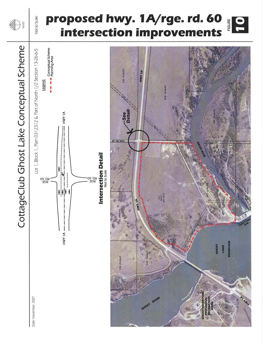
25 8.0 TRANSPORTATION The Plan Area is bounded by Highway 1A to the north and Range Road 60 to the east. Highway 1A adjacent to the Plan Area is a two lane, undivided highway with a 100 kilometre per hour posted speed limit. Range Road 60 is a municipal roadway developed to a two lane, gravel standard. The Highway 1A/Range Road 60 intersection has stop signs on Range Road 60, north and south of Highway 1A. Currently there is no turn or merge lanes provided at this intersection. Alberta Infrastructure and Transportation (AIT) and the Municipal District have indicated that the overall road network in the vicinity of the Plan Area will remain with no new roadways proposed. Based on information provided by Alberta Infrastructure and Transportation, upgrades to Highway 1A are being considered as follows: Highway 1A will be twinned from the existing divided four lane section, east of the Town of Cochrane through to Horse Creek Road. Timing of this twinning is uncertain. Highway 1A, starting approximately 1 kilometre west of the Plan Area, will be widened through to Highway 1X. This widening is scheduled for The Municipal District has indicated that Range Road 60 will continue to function as a local, rural standard roadway and it has no plans to upgrade this roadway. Access to the Plan Area will be via Range Road 60. An internal road system, owned and maintained by the condominium association, will be constructed in phases to the satisfaction of the Municipality. An emergency access will be provided off of Highway 1A in the location illustrated on Figure 7. Subject to approval by the Municipality, the internal road system has been designed with traffic circles at all major intersections. The traffic circles will facilitate reduced travel speeds throughout the project. Page Policy: The internal road network shall be as generally illustrated in Figure Policy: The internal road network shall be constructed by the developer, maintained by a condominium association and constructed to a standard satisfactory to the Municipality. 8.1 Traffic Impact Assessment D.A. Watt Consulting prepared a traffic impact assessment for the proposed development in September The purpose of the assessment was to examine the operation of the Highway 1A/ Range Road 60 intersection. The traffic impact assessment also confirmed that CottageClub Ghost Lake will generate approximately 79 inbound vehicles per hour during the summer Friday afternoon peak hour, 98 outbound vehicles per hour during the summer Sunday afternoon peak hour on a seasonal basis only. Increased traffic volumes due to CottageClub Ghost Lake are expected to be minimal outside of peak summer months. The transportation analysis recommended that the Highway 1A/Range Road 60 intersection be upgraded to a Type IVb standard as illustrated in Figure 10. The assessment suggested that traffic signals are not warranted at the Highway 1A/Range Road 60 intersection Policy: In accordance with the recommendations identified by the traffic impact assessment, improvements to the intersection at Highway 1A and Range Road 60, as generally illustrated on Figure 10, shall be implemented to the satisfaction of Alberta Infrastructure and Transportation, and the Municipality Policy: Range Road 60 shall be upgraded, at the developer s expense, from Highway 1A to the entrance of the park to a standard acceptable to the Municipality.
26 Page 21

27 Page 22 Where improvements to Range Road 60 or to the Highway 1A and Range Road 60 intersection are deemed to benefit adjacent lands, the Municipality, through a Latecomers Agreement, may reimburse the developer. 9.0 SERVICING SCENARIO As noted earlier, it is the intention that CottageClub Ghost Lake be established and maintained as a recreation development. A key factor in maintaining the intended recreational integrity of the project is to limit the type and extent of services that will be provided to each cabin. 9.1 Water and Sanitary Sewer The water and sanitary sewer systems will have limited capacity. Water for cabin use will be provided by two wells located on-site with a treatment and distribution system. This system will supply water to all the cabins from April to October and the system to the cabins will be taken out of service during the winter months. Water will also be provided to the two washroom facilities and the recreation and learning centre via the piped distribution system on a year-round basis. Sanitary sewer will be accommodated by holding tanks located on each lot. The effluent from each will be trucked and disposed of off-site Policy: Prior to subdivision approval, confirmation that water can be supplied to the Plan Area shall be provided by Alberta Environment Policy: The water system shall be designed to the satisfaction of Alberta Environment and the Municipality, and constructed at the sole expense of the developer Policy: Water service shall be provided to all cabin lots via a community distribution system that is operational from April to October. The system that supplies water to the cabin lots shall be taken out of service during the winter months Policy: Water to the common washrooms and the caretaker residence will be provided on a year-round basis Policy: Sanitary sewer service to the cabins shall be provided by pump-out tanks installed at the sole expense of the developer. The pump-out tanks are to be designed, located, and approved in accordance with provincial and municipal requirements, and are to be owned by the condominium association with exclusive use and operating costs being the responsibility of each cabin owner Policy: Prior to subdivision approval, the developer shall provide confirmation that effluent from the Plan Area will be received by a wastewater treatment facility acceptable to Alberta Environment and the Municipality Policy: Installation of the water distribution system and pump-out tanks for all washrooms and the recreation and learning centre located within the open space system shall be installed at the sole expense of the developer Policy: A condominium association shall be incorporated to manage and maintain the water distribution system and pump-out tanks associated with the common washrooms, the recreation and learning centre, and the caretaker residence.
28 9.2 Stormwater Management Urban Systems has prepared a preliminary stormwater management report for the proposed development. The purpose of the report is to present the stormwater drainage concepts that will form the basis of the drainage plan that will service the community. The concepts show how runoff will be managed to meet Alberta Environment guidelines. The stormwater concept is to minimize disturbance to existing vegetation by having the runoff follow existing drainage patterns, and to address the stormwater via infiltration. Runoff that is not intercepted by the roadside infiltration ditches will drain to centralized infiltration facilities that will be constructed in the existing low areas of each subcatchment. Therefore, no regional stormwater detention ponds are required. The development as a whole will be designed such that all runoff up to and including the 1:100 year event will be disposed of by infiltration. However, the development roadways will be designed with appropriately located emergency overland spill routes to external areas Policy: All stormwater management within the Plan Area shall be designed and constructed to MD servicing standards and in general conformance with the 2006 Urban Systems Stormwater Management Plan Policy: The post-development stormwater runoff rate from the Plan Area shall be no greater than the pre-development rate with a quality consistent with Alberta Environment guidelines Policy: Stormwater management facilities shall be designed to minimize standing water Policy: The stormwater management facilities shall be constructed by the developer and maintained by the condominium association. 9.3 Private Utilities A limited range of private utilities will be provided. Only electric service will be provided to the cabins. No natural gas, telephone or cable television will be installed to the cabins. By limiting the extent of services offered, the intended use as a recreational community will be encouraged and year-round permanent residency will be discouraged Policy: In order to encourage non-permanent occupancy, only electrical service will be provided to each cabin lot. No natural gas, telephone or cable television will be installed to the cabins. 9.4 Solid Waste Management Solid waste will be accommodated through a centralized collection area adjacent to Range Road 60, south of the main access road. This area will include both a garbage collection bin and a recycling depot. Residents will access the area off the internal road. There will be no garbage storage on any cottage lot with residents disposing of their solid waste through the centralized collection and disposal facility. The collected material will then be trucked off-site and disposed of in a sanitary landfill site or recycling facility Policy: Solid waste will be collected at a centralized storage and recycling facility as illustrated on Figure 7. There will be no collection system with residents being required to bring the solid waste to the central collection area and recycling depot Policy: The condominium association shall be responsible for the operation and maintenance of the solid waste collection and recycling depot. Page 23

29 Page 24
30 10.0 PROTECTIVE SERVICES Protective services will have efficient access into the Plan Area from the primary entrance off of Highway 1A onto Range Road 60. A secondary emergency access will be provided off of Highway 1A in the northwest corner of the site. Police services will be provided by the Royal Canadian Mounted Police and the Municipal District of Rocky View Special Constables. Emergency medical services will be provided by the Town of Cochrane from an emergency response centre in the Town. The primary source of fire protection is from the Ghost Lake Reservoir with water for fire fighting provided by a distribution system through the development of watermains and dry hydrants Policy: Central water source for fire protection shall be provided through the use of the Ghost Lake Reservoir and dry hydrants in accordance with the requirements of the Municipality PROPOSED PHASING Figure 12 illustrates the proposed phasing plan. Part 1 of the Plan Area, as outlined earlier on Figure 4, is to remain undeveloped consistent with its use in conjunction with the existing hydrogeneration facility. The balance of the Plan Area will be developed in phases. The boat launch and dock, and the main internal road that accesses them, will be developed as part of the first phase. In addition, a common area washroom will also be developed in Phase 1 along with the initial cell of cabin lots. Phase 2 will include the construction of the recreation and learning centre, the second washroom, the maintenance building, and recycling centre along with the second cell of cabin lots. Subsequent phases will be initiated as market conditions dictate. Page Policy: Figure 12 is intended to provide a general indication on how phasing may occur. The sequence, size and areas included in each phase may vary without a need to amend this Conceptual Scheme PROPOSED LAND USE This Conceptual Scheme proposes Parts 2 and 3 of the Plan Area be designated a Direct Control District (DC) to accommodate the recreational cabin development, and associated boat launch and dock. The uses proposed specifically for the Plan Area include single-detached recreational cabins among the list of permitted uses, as well as accessory buildings, utilities, trails, local convenience store, recreation and learning centre, boat dock, common area washrooms and showers, and open spaces. This list of permitted uses will be subject to a set of development requirements that will form part of the proposed Direct Control Bylaw Policy: Applications for land use amendments within the Plan Area shall establish land uses, appropriate building setbacks and development regulations, and shall be consistent with the intent of this Conceptual Scheme PUBLIC CONSULTATION Starting in 2005, various stakeholders have been contacted including adjacent landowners, Municipal District of Rocky View staff, Municipal District of Bighorn, the Summer Village of Ghost Lake, Alberta Environment, Alberta Infrastructure and Transportation, TransAlta, and residents of Ghost Lake Village. In addition, and as per the direction of the Municipality, open houses were held on November 15, 2006 and September 12, The events were held at the Beaupre Community Hall facility located approximately 2 kilometres from the development. The purpose of the open houses was to inform interested parties and

31 Page 26
32 obtain comments respecting the proposed recreational cabin development of CottageClub Ghost Lake. The information provided at the open house included: location display panels (Plan Area context map, MD map, plan area photos); plan area characteristic panels (contour mapping, cross sections); sample cabin product photographs; and comment sheets were also provided and then collected as the attendee departed. Thirty-two people attended the November 15, 2006 open house. Attendees recorded their land location as follows: Municipal District of Rocky View - Division 9 3 (9.3%) - Other Divisions 6 (18.8%) Municipal District of Bighorn 9 (28.1%) Town of Cochrane 8 (25.0%) City of Calgary 6 (18.8%) Total 32 (100%) On September 12, 2007, a second open house was held and 73 people signed in. Attendees of the second open house indicated their land location as follows: Municipal District of Rocky View - Division 9 11 (15%) - Other Divisions 4 (5%) Municipal District of Bighorn 27 (37%) Town of Cochrane 16 (22%) City of Calgary 15 (21%) Total 73 (100%) The developer also met individually with 26 of the area landowners. Comments received from the landowners were considered and where appropriate incorporated into this Conceptual Scheme. Based on the comments provided, both verbal and written, the overall feeling was that the proposed development complements existing adjacent recreational uses and at the same time sets a standard for low impact environmentally friendly cabin development. There were comments relative to the potential increase in traffic, both on the adjacent highway and on the reservoir. Based on these comments, the proposed grocery store was relocated within the recreation and learning centre thereby ensuring CottageClub Ghost Lake residents had access to the store. Further a proposed farmers market was eliminated from the project. With respect to boat traffic, accepted standards were reviewed and applied to the Ghost Lake reservoir. Through this review, it was concluded that the reservoir operates at a level far less than comparable recreational amenities STATUTORY PLAN COMPLIANCE The Plan Area is not currently included in any area structure plan and, as such, policy direction is provided by the Municipal Development Plan. CottageClub Ghost Lake will be a development unique within the Municipality and one that was not directly anticipated by the MDP. Nevertheless, the MDP does provide rationale and planning principles that support the development of CottageClub Ghost Lake. The following is a review of the goals, philosophy and policies of the MDP as they relate to the proposed development Mission Statement and Statement of Goals The MDP, at the outset, establishes a number of goals that set the tone for the balance of the plan. There are several goals that are relevant to and encourage the CottageClub Ghost Lake Conceptual Scheme. They are: 1. Council shall develop policies as required and revise current policies to ensure good government in the Municipality. Page 27
BYLAW C A Bylaw of Rocky View County to amend Land Use Bylaw C
 BYLAW C-7720-2017 A Bylaw of Rocky View County to amend Land Use Bylaw C-4841-97. The Council of Rocky View County enacts as follows: PART 1 TITLE This Bylaw shall be known as Bylaw C-7720-2017. PART 2
WESTMINSTER GLEN CONCEPTUAL SCHEME
 WESTMINSTER GLEN CONCEPTUAL SCHEME Bylaw C-5379-2001, Adopted July 31, 2001 MUNICIPAL DISTRICT OF ROCKY VIEW NO. 44 Department of Planning and Development MUNICIPAL DISTRICT OF ROCKY VIEW NO. 44 BYLAW
City of Grande Prairie Development Services Department KENNEDY DEVELOPMENTS LTD. OUTLINE PLAN OP-09-01
 City of Grande Prairie Development Services Department KENNEDY DEVELOPMENTS LTD. OUTLINE PLAN OP-09-01 July 27, 2009 TABLE OF CONTENTS 1.0 Introduction... 1 1.1 Plan Area Location & Context... 1 1.2 Ownership
WEST HILL BUSINESS PARK AREA STRUCTURE PLAN
 MUNICIPAL DISTRICT OF PEACE NO. 135 WEST HILL BUSINESS PARK AREA STRUCTURE PLAN Prepared by: TABLE OF CONTENTS 1.0 Introduction... 1 1.1 Purpose of Plan........ 1 1.2 Plan Area..... 1 1.3 Existing Conditions...
GRAYSTONE ESTATES CONCEPTUAL SCHEME
 GRAYSTONE ESTATES CONCEPTUAL SCHEME Bylaw C-5438-2001, Adopted November 6, 2001 MUNICIPAL DISTRICT OF ROCKY VIEW NO. 44 Department of Planning and Development TABLE OF CONTENTS 1.0 INTRODUCTION 5 1.1 Conceptual
SANDSTONE SPRINGS AREA STRUCTURE PLAN
 Sandstone Springs Development Corp. AREA STRUCTURE PLAN This report is prepared for the sole use of Sandstone Springs Development Corp. No representations of any kind are made by Urban Systems Ltd. or
Municipal Development Plan. Summer Village of ROCHON SANDS. Bylaw #241-18
 Municipal Development Plan Summer Village of ROCHON SANDS Bylaw #241-18 TABLE OF CONTENTS PART ONE: BACKGROUND AND PURPOSE 3 SECTION 1: BACKGROUND 3 SECTION 2: GOALS AND POLICIES 3 PART TWO: PHYSICAL ENVIRONMENT
CONCEPTUAL SCHEME FULTON INDUSTRIAL
 CONCEPTUAL SCHEME FULTON INDUSTRIAL Bylaw C-6919-2010 Adopted June 22, 2010 ROCKY VIEW COUNTY BYLAW C-6919-2010 A Bylaw of Rocky View County to adopt a Conceptual Scheme known as the Fulton Industrial
AREASTRUCTURE PLAN AMENDMENT COCHRANE NORTH
 AREASTRUCTURE PLAN AMENDMENT COCHRANE NORTH In order to implement the vision outlined in the Conceptual Scheme, the following three amendments to the Cochrane North ASP are proposed: 1. Allow commercial
OP Council Resolution June 16, Planning and Development Services
 OP-08-01 Council Resolution June 16, 2008 Planning and Development Services Kingsgate Landing Outline Plan Table of Contents 1.0 Introduction 1 1.1 Purpose of Plan 1 1.2 Plan Area Location 1 1.3 Ownership
MUNICIPAL DISTRICT OF ROCKY VIEW NO.
 BEARSPAW AREA STRUCTURE PLAN Bylaw C-4129-93, Adopted January 18, 1994 MUNICIPAL DISTRICT OF ROCKY VIEW NO. 44 Department of Planning and Development BEARSPAW AREA STRUCTURE PLAN BY-LAW C-4129-93 January,
City of Grande Prairie Development Services Department
 City of Grande Prairie Development Services Department ROYAL OAKS NORTH OUTLINE PLAN OP-07-03 NW 35-71-6 W6M May 7, 2007 Royal Oaks North Outline Plan TABLE OF CONTENTS 1.0 INTRODUCTION........ 3 1.1 Purpose
TABLE OF CONTENTS 1.0 INTRODUCTION GENERAL OBJECTIVES LAND USE DESIGNATIONS, OBJECTIVES AND POLICIES 4
 Schedule I- Redstone Golf Course Resort Area Sector Plan 1 TABLE OF CONTENTS 1.0 INTRODUCTION 3 2.0 GENERAL OBJECTIVES 3 3.0 LAND USE DESIGNATIONS, OBJECTIVES AND POLICIES 4 4.0 TRANSPORTATION AND ROAD
Leduc Industrial Outline Plan SE W4
 Leduc Industrial Outline Plan SE 1-50-25-W4 Within the North Leduc Industrial ASP Prepared for: Leduc Energy Park Ltd. Prepared by: Stantec Consulting Ltd. File No. 1161 104655 V5 Table of Contents 1.0
Red Fox Commercial Outline Plan
 Red Fox Commercial Outline Plan City of Cold Lake, Alberta Prepared by Durrance Projects Ltd and Ross W. Sharp & Associates Ltd October 2014 Rupert 1 Table of Contents 1. PURPOSE...3 1.1. Location...4
LAND USE AMENDMENT CORNERSTONE (WARD 3) 60 STREET NE AND COUNTRY HILLS BOULEVARD NE MAP 26NE BYLAW 22D2017
 60 STREET NE AND COUNTRY HILLS BOULEVARD NE MAP 26NE BYLAW 22D2017") Page 1 of 14 EXECUTIVE SUMMARY This Land Use Amendment application covers an area of 43.76 hectares ± (108.14 acres ±) located in northeast Calgary, bound by Country Hills Boulevard NE to the south and
Page 1 of 14 EXECUTIVE SUMMARY This Land Use Amendment application covers an area of 43.76 hectares ± (108.14 acres ±) located in northeast Calgary, bound by Country Hills Boulevard NE to the south and
MUNICIPAL DEVELOPMENT PLAN
 MUNICIPAL DEVELOPMENT PLAN Bylaw C-4840-97 Adopted on July 6, 1998 MUNICIPAL DISTRICT OF ROCKY VIEW NO. 44 Department of Planning and Development & Building Services MUNICIPAL DISTRICT OF ROCKY VIEW NO.
SUMMER VILLAGE OF SUNRISE BEACH
 SUMMER VILLAGE OF SUNRISE BEACH Municipal Development Plan Bylaw No. 132-13 ~ 2 ~ Summer Village of Sunrise Beach Municipal Development Plan 1 INTRODUCTION 1.1 SETTING The Summer Village of Sunrise Beach
Land Use Amendment in Southwood (Ward 11) at and Elbow Drive SW, LOC
 at and Elbow Drive SW, LOC") 2018 November 15 Page 1 of 10 EXECUTIVE SUMMARY This land use amendment application was submitted by Rick Balbi Architect on 2017 August 31 on behalf of Sable Developments Ltd, and with authorization from
2018 November 15 Page 1 of 10 EXECUTIVE SUMMARY This land use amendment application was submitted by Rick Balbi Architect on 2017 August 31 on behalf of Sable Developments Ltd, and with authorization from
ADMINISTRATION RECOMMENDATION 2016 November 03. That Calgary Planning Commission recommends APPROVAL of the proposed Land Use Amendment.
 Page 1 of 12 EXECUTIVE SUMMARY This Land Use Amendment application covers an area of 75.76 hectares ± (187.20 acres ±) located in northeast Calgary, bound by Stoney Trail NE to the north, 128 Avenue NE
TOWN OF BRUDERHEIM Report to the capital region board
 TOWN OF BRUDERHEIM Report to the capital region board Introduction to the Town of Bruderheim Municipal Development Plan amendment and Relation to the CRB Evaluation Criteria 02 march 2017 1 Introduction
INDUS AREA STRUCTURE PLAN
 INDUS AREA STRUCTURE PLAN Bylaw C-5982-2004, Adopted November 9, 2004 MUNICIPAL DISTRICT OF ROCKY VIEW NO. 44 Department of Planning and Development MUNICIPAL DISTRICT OF ROCKY VIEW NO. 44 BYLAW C-5982-2004
S o u t h C e n t r a l O u t l i n e P l a n. Leduc Business Park. North Leduc Industrial Area Structure Plan C it y of Led u c.
 Leduc Business Park North Leduc Industrial Area Structure Plan C it y of Led u c Prepared for Farm Air Properties Inc. January, 2007 Table of Contents Page Number 1.0 Purpose of Plan and Definition of
The Uplands Area Structure Plan. City of Cold Lake, NE & SE W4
 City of Cold Lake, NE & SE 13-63-2-W4 July 2009 1 Contents 1 Background information... 1 1.1 Foreword... 1 1.2 Purpose... 1 1.3 Plan Area and Location... 1 1.4 Ownership... 2 2 Factors Influencing Development...
ARTICLE VI: SITE PLAN REVIEW
 Section 6.01 - Site Plan Review (All Districts) ARTICLE VI: SITE PLAN REVIEW Site plans give the Planning commission an opportunity to review development proposals in a concise and consistent manner. The
C ity of Grande Prairie Development Services Department
 C ity of Grande Prairie Development Services Department FAIRWAY DEVELOPMENT OUTLINE PLAN OP 08 09 Approved April 6, 2009 Prepared by: Focus Corporation Table of Contents 1.0. Introduction 2 3 1.1. Plan
Outline Plan in Belvedere (Ward 9) at Street SE, LOC (OP)
 at Street SE, LOC (OP)") 2018 October 04 Page 1 of 12 EXECUTIVE SUMMARY This outline plan application was submitted by B&A Planning Group on 2016 July 15, on behalf of Tristar Communities Inc. for 50.14 hectares (123.89 acres)
2018 October 04 Page 1 of 12 EXECUTIVE SUMMARY This outline plan application was submitted by B&A Planning Group on 2016 July 15, on behalf of Tristar Communities Inc. for 50.14 hectares (123.89 acres)
Area Structure Plan. A Community for All Seasons. Prepared for the Town of Strathmore. Consolidated September 28, 2015
 Area Structure Plan Prepared for the Town of Strathmore A Community for All Seasons Lakewood Meadows Area Structure Plan Prepared for the Town of Strathmore And Lakewood Meadows Inc. i Table of Contents
HAMLET OF KINGMAN AREA STRUCTURE PLAN
 HAMLET OF KINGMAN AREA STRUCTURE PLAN Prepared by: Austrom Consulting Ltd. Page 1 of 19 Table of Contents TABLE OF CONTENTS... 2 1. BACKGROUND... 3 1.1 PLAN AREA... 3 1.2 PLAN PURPOSE... 3 1.3 LEGISLATIVE
DAMKAR LANDS An Amendment to Bylaw C being the Watermark Conceptual Scheme
 APPENDIX 8 DAMKAR LANDS An Amendment to Bylaw C-6798-009 being the Watermark Conceptual Scheme Table of Contents 1.0 Introduction 1.0 Development Objectives 1 3.0 History, Vision and Guiding Principles
North Oakville East Parks Facilities Distribution Plan. November, 2009
 North Oakville East November, 2009 POLICY CONTEXT 1) Purpose a) The purpose of this document is to be a guide for the location, configuration, design and development of the parks system for the North Oakville
13. VANDORF-PRESTON LAKE SECONDARY PLAN 13.1 INTRODUCTION
 13. VANDORF-PRESTON LAKE SECONDARY PLAN 13.1.1 Purpose 13.1 INTRODUCTION The Vandorf-Preston Lake Secondary Plan establishes the principles, objectives and general policies, as well as specific strategies
LAND USE AMENDMENT CORNERSTONE (WARD 3) COUNTRY HILLS BOULEVARD AND STONEY TRAIL NE BYLAW 9D2017
 COUNTRY HILLS BOULEVARD AND STONEY TRAIL NE BYLAW 9D2017") Page 1 of 12 EXECUTIVE SUMMARY This Land Use Amendment application covers an area of 54.92 hectares ± (135.71 acres ±) located in northeast Calgary, bound by Country Hills Boulevard NE to the north and
Page 1 of 12 EXECUTIVE SUMMARY This Land Use Amendment application covers an area of 54.92 hectares ± (135.71 acres ±) located in northeast Calgary, bound by Country Hills Boulevard NE to the north and
Ten Mile Creek Planning Area
 PLANNING AREA POLICIES TEN MILE CREEK Ten Mile Creek Planning Area Location and Context The Ten Mile Creek Planning Area ( Ten Mile Creek area ) is located south of the current Boise AOCI, generally south
Project phasing plan (if applicable) 12 copies of site plan
 12 copies of site plan") SITE PLAN REVIEW PERMIT APPLICATION City of Grand Haven, 11 N. Sixth Street, Grand Haven, MI 49417 Phone: (616) 847-3490 Fax: (616) 844-2051 Website: www.grandhaven.org 1. Project Information Address/location
SITE PLAN REVIEW PERMIT APPLICATION City of Grand Haven, 11 N. Sixth Street, Grand Haven, MI 49417 Phone: (616) 847-3490 Fax: (616) 844-2051 Website: www.grandhaven.org 1. Project Information Address/location
PORT WHITBY COMMUNITY
 PORT WHITBY COMMUNITY SECONDARY PLAN UPDATE COMMUNITY IMPROVEMENT PLAN URBAN DESIGN GUIDELINES September 2015 DRAFT PROPOSED AMENDMENT NUMBER # to the Whitby Official Plan PURPOSE: The intent of this Amendment
March 21, 2018 ALCA Meeting. March 21, 2018
 March 21, 2018 ALCA Meeting March 21, 2018 Agenda 1. Process and Timeline 2. Original Submission 3. Revised Submission 4. Next Steps The City of Calgary Role: The City is responsible for capturing and
6 PORT SYDNEY SETTLEMENT AREA
 Section 6 Port Sydney Page 61 6 PORT SYDNEY SETTLEMENT AREA 6.1 Basis and Principles Village of Port Sydney Waterfront Community Existing Services 6.1.1 Port Sydney is an historic settlement that has developed
Bylaw C-1186 Adopted November 5, Planning and Development Services
 Bylaw C-1186 Adopted November 5, 2007 Planning and Development Services CITY OF GRANDE PRAIRIE OFFICE CONSOLIDATION BYLAW C-1186 A Bylaw to adopt the Westgate Area Structure Plan (As Amended by Bylaw C-1186-1,
Palisades Outline Plan
 NE ¼ 25 36 28 W4 Town of Penhold Approved August 13, 2012 Contents Figures & Tables... 2 Introduction... 1 Overview... 1 Purpose... 1 Development Area... 3 Ownership... 3 Topography... 3 Existing & Surrounding
CENTRAL PARK MAJOR AREA STRUCTURE PLAN. Bylaw No. 2017/30, Adopted February 20, P a g e
 CENTRAL PARK MAJOR AREA STRUCTURE PLAN Bylaw No. 2017/30, Adopted February 20, 2018 1 P a g e Table of Contents 1.0 Introduction 4 1.1 Background 4 1.2 Purpose 4 1.3 Location 4 1.4 Planning Process 4
BRIDGES OF LANGDON CONCEPTUAL SCHEME
 BRIDGES OF LANGDON CONCEPTUAL SCHEME Office Consolidation This page contains the history of relevant bylaws affecting this office consolidation. A copy of the original Bylaw and all amending Bylaws can
A Guide to Open Space Design Development in Halifax Regional Municipality
 A uide to Open Space Design Development in Halifax Regional Municipality May 2007 1 Introduction Pursuant to Section 3.5 of the Regional Municipal Planning Strategy (RMPS), subdivision of land may proceed
Master Site Development Plan (MSDP) Rocky View County Campus at Balzac East
 Rocky View County Campus at Balzac East") Master Site Development Plan (MSDP) Rocky View County Campus at Balzac East Balzac East, Alberta July 2009 CONTENTS 1.0 purpose 1 2.0 guiding principles 2 3.0 site description 3 4.0 site analysis and county
Master Site Development Plan (MSDP) Rocky View County Campus at Balzac East Balzac East, Alberta July 2009 CONTENTS 1.0 purpose 1 2.0 guiding principles 2 3.0 site description 3 4.0 site analysis and county
Request for Decision. Recommendation. Presented: Monday, Jul 07, Report Date Friday, Jun 20, Type: Public Hearings
 Presented To: Planning Committee Request for Decision Application for rezoning in order to permit a place of worship on a vacant lot zoned for C1, Local Commercial uses, Cam Street, Sudbury Sitiri Investments
Town of Portola Valley General Plan. Nathhorst Triangle Area Plan
 Town of Portola Valley General Plan Amended December 10, 1997 Table of Contents Introduction... 1 Planning Area... 1 Objectives... 2 Principles... 2 Standards... 4 Description... 4 Community Commercial...
A Growing Community Rural Settlement Areas
 Town of Huntsville Official Plan Review - POLICY BACKGROUND PAPER A Growing Community Rural Settlement Areas BACKGROUND: In addition to the fully municipally-serviced Urban Settlement Area and the Hidden
ADMINISTRATION RECOMMENDATION(S) 2017 June 15. That Calgary Planning Commission recommends APPROVAL of the proposed Land Use Amendment.
 2017 June 15. That Calgary Planning Commission recommends APPROVAL of the proposed Land Use Amendment.") Page 1 of 7 EXECUTIVE SUMMARY The proposed land use amendment seeks to redesignate a Special Purpose Future Urban Development (S-FUD) District parcel in Residual Ward 3 Sub Area 3H to Industrial Outdoor
Page 1 of 7 EXECUTIVE SUMMARY The proposed land use amendment seeks to redesignate a Special Purpose Future Urban Development (S-FUD) District parcel in Residual Ward 3 Sub Area 3H to Industrial Outdoor
CHAPTER 22 Rural Open Space Community Developments
 CHAPTER 22 Rural Open Space Community Developments Section 22.1 Description and Purpose The intent of this Chapter is to offer property owners an alternative to traditional zoning requirements for rural
ARTICLE 6: Special and Planned Development Districts
 ARTICLE 6: Special and Planned Development Districts 6-10 Traditional Neighborhood Development (TND) District 6-10.10 Purpose and Intent The Traditional Neighborhood Development (TND) District provides
The West Vaughan Employment Area Secondary Plan Policies
 Part 2: The West Vaughan Employment Area Secondary Plan Policies 2.1 General Policies It is the policy of Council: 2.1.1. That the West Vaughan Employment Area (the WVEA), identified on Schedule 1, will
Ashbridges Bay Erosion and Sediment Control Project
 Ashbridges Bay Erosion and Sediment Control Project Project Brief Overview Toronto and Region Conservation Authority, in partnership with the City of Toronto, intends to carry out remedial erosion control
ARTICLE 17 SITE PLAN REVIEW
 ARTICLE 17 SITE PLAN REVIEW 17.01 INTENT AND PURPOSE The intent of this section is to provide for consultation and cooperation between the applicant and the township planning commission so that the applicant
Bylaw C-1262 Adopted February 6, Planning and Development Department
 Bylaw C-1262 Adopted February 6, 2012 Planning and Development Department CITY OF GRANDE PRAIRIE BYLAW C-1262 A Bylaw to adopt the Brookfield Neighbourhood Outline Plan THE MUNICIPAL COUNCIL OF THE CITY
COMMUNITY DESIGN. GOAL: Create livable and attractive communities. Intent
 COMMUNITY DESIGN Intent An attractive, well-designed County will attract quality development, instill civic pride, improve the visual character of the community, and create a strong, positive image for
12 January 12, 2011 Public Hearing APPLICANT: TAILWIND DEVELOPMENT GROUP,LLC PROPERTY OWNER: CITY OF VIRGINIA BEACH
 12 January 12, 2011 Public Hearing APPLICANT: TAILWIND DEVELOPMENT GROUP,LLC PROPERTY OWNER: CITY OF VIRGINIA BEACH STAFF PLANNER: Faith Christie REQUEST: Conditional Change of Zoning (from PD-H1 Planned
TABLE OF CONTENTS. Sierra Springs Outline Plan
 Sierra Springs Outline Plan TABLE OF CONTENTS 1. Introduction...3 1.1. Purpose of the Plan... 3 1.2. The Approval Process... 3 1.3. Policy and Legislative Framework... 3 2. Development Area...6 2.1. Location
GATEWAY AREA STRUCTURE PLAN
 CHESTERMERE GATEWAY AREA STRUCTURE PLAN COMMUNITY OPEN HOUSE SEPTEMBER 22 nd, 2015 PLAN AREA ± 512 hectares (± 1,265 acres) GATEWAY LOCATION UNDEVELOPED LANDS PRESENT AGRICULTURAL USE REGIONAL LAND USE
ADMINISTRATION RECOMMENDATION(S) 2018 January 25. That Calgary Planning Commission recommend APPROVAL of the proposed Land Use Amendment.
 2018 January 25. That Calgary Planning Commission recommend APPROVAL of the proposed Land Use Amendment.") Page 1 of 9 EXECUTIVE SUMMARY This land use amendment proposes to redesignate a parcel from DC Direct Control District to Multi-Residential Contextual Grade-Oriented (M-CG) District to allow for multi-residential
Page 1 of 9 EXECUTIVE SUMMARY This land use amendment proposes to redesignate a parcel from DC Direct Control District to Multi-Residential Contextual Grade-Oriented (M-CG) District to allow for multi-residential
TOWNSHIP OF LOGAN SOIL & FILL IMPORTATION AND PLACEMENT APPLICATION SUBMITTAL CHECKLIST
 TOWNSHIP OF LOGAN SOIL & FILL IMPORTATION AND PLACEMENT APPLICATION SUBMITTAL CHECKLIST Applications: 5 copies of application - Applicant will reproduce the copies at his/her costs. The Township Clerk
Proposed Kenmount Hill CDS Amendment. Public Hearing October 25 th, 2018
 Proposed Kenmount Hill CDS Amendment Public Hearing October 25 th, 2018 History of Kenmount Hill Why Kenmount Hill? Why Now? We are a city with a vision for growth and the development of Kenmount Hill
Welcome. Walk Around. Talk to Us. Write Down Your Comments
 Welcome This is an information meeting introducing the applications for proposed redevelopment of the Yorkdale Shopping Centre site at 3401 Dufferin Street and 1 Yorkdale Road over the next 20+ years,
Westwind Developments Ltd. PIONEER LANDS AREA STRUCTURE PLAN - PROPOSED AMENDMENT
 FEBRUARY 2013 TABLE OF CONTENTS 1.0 BACKGROUND... 1 1.1 Amendment... 1 2.0 LOCATION & CONTEXT... 2 2.1 Land Ownership... 2 3.0 POLICY CONTEXT... 3 3.1 Municipal Development Plan... 3 3.2 Capital Region
6 Growth Management Challenges and Opportunities
 6 Growth Management Challenges and Opportunities The Town has established a goal of attaining a 50% participation rate with respect to employment opportunities versus residential population. The Town s
Town of Peru Comprehensive Plan Executive Summary
 Town of Peru Comprehensive Plan Executive Communities that plan grow by choice, not by chance. A plan makes growth thoughtful, understandable, and predictable. A plan shows that a community is managing
Chapter Master Planned Communities (MPC) District
 District") Sections 14.53.010 Purpose and Intent 14.53.020 Applicability 14.53.030 Procedure 14.53.040 MPC Standards 14.53.050 Required Findings 14.53.010 Purpose and Intent Chapter 14.53 Master Planned Communities
Sections 14.53.010 Purpose and Intent 14.53.020 Applicability 14.53.030 Procedure 14.53.040 MPC Standards 14.53.050 Required Findings 14.53.010 Purpose and Intent Chapter 14.53 Master Planned Communities
MOUNTAIN VIEW COUNTY. BYLAW NO. 1Ol13 WATER VALLEY/ WINCHELL.AKE AREA STRUCTURE PLAN
 MOUNTAIN VIEW COUNTY BYLAW NO. 1Ol13 WATER VALLEY/ WINCHELL.AKE AREA STRUCTURE PLAN Page 2 Bylaw No. 10113 Mountain View County Province of Alberta Bylaw No. 10113 A BYLAW OF MOUNTAIN VIEW COUNTY IN THE
Section H: Waterfront
 Section H: Waterfront Waterfront Designation The waterfront designation describes the shoreline communities, which are located around the lakes or along the significant rivers in the Township. These communities
General Location Annex, Rezone & Preliminary Plat Lansdowne Addition, Unit Three
 NEWFOUNDLAND I-5 Agricultural District Subject Site SUNDANCE ANDERSON Single Family Residential CHRISTY PUD Agricultural District Highway Business General Location Annex, Rezone & Preliminary Plat Lansdowne
150 Eighth Street Zoning By-law Amendment Application Preliminary Report
 REPORT FOR ACTION 150 Eighth Street Zoning By-law Amendment Application Preliminary Report Date: March 27, 2019 To: Etobicoke York Community Council From: Director, Community Planning, Etobicoke York District
At Your Disposal CUP Amendment, Lot 20, Village Service Commercial, at 128 Bastille Dr. (PLN17-208)
") MEMORANDUM Archuleta County Development Services Planning Department 1122 HWY 84 P. O. Box 1507 Pagosa Springs, Colorado 81147 970-264-1390 Fax 970-264-3338 TO: Archuleta County Planning Commission FROM:
MEMORANDUM Archuleta County Development Services Planning Department 1122 HWY 84 P. O. Box 1507 Pagosa Springs, Colorado 81147 970-264-1390 Fax 970-264-3338 TO: Archuleta County Planning Commission FROM:
Mitchell Ranch South MPUD Application for Master Planned Unit Development Approval Project Narrative. Introduction
 Mitchell Ranch South MPUD Application for Master Planned Unit Development Approval Project Narrative Introduction Mitchell Ranch South is a proposed single family (detached) residential development on
Applicant Name Phone / Fax / Address City State Zip Code . Property Owner Phone / Fax / Address City State Zip Code
 Master Development Plan Application Community Development Department City of Redmond 411 SW 9 th Street Redmond, Oregon 97756 541-923-7721 541-548-0706 FAX Master Development Plan Fee $38,862.52 File Number
APPLICATION BRIEFING Prepared For: Submitted by: Date: Subject:
 Planning & Development APPLICATION BRIEFING Prepared For: Submitted by: Date: Subject: Planning Advisory Committee Jason Fox, Director of Planning & Development Development Agreement application by Godfrey
Mill Conversion Overlay District Zoning Bylaw Amendment
 Mill Conversion Overlay District Zoning Bylaw Amendment To see if the Town will vote to amend the Zoning By-Law by adding a new Section 13, Mill Conversion Overlay District, and by amending Sections 2.1,
KASPER. City of Georgetown, Texas PUD Planned Unit Development. December 30, 2015 Revised January 27, 2016
 KASPER City of Georgetown, Texas PUD Planned Unit Development December 30, 2015 Revised January 27, 2016 Applicant: Sentinel Land Company, LLC 4910 Campus Drive Newport Beach, CA Prepared by: SEC Planning
6 RURAL RESIDENTIAL. 6.1 Rural Use. Rural Use (RU) Goals and Objectives. Policy Goal
 Goals and Objectives. Policy Goal") 6 RURAL RESIDENTIAL The vast majority of East Hants 466,426 acres are considered rural in nature and are characterized by a great diversity of uses. Because of this, land use policies in rural areas of
6 RURAL RESIDENTIAL The vast majority of East Hants 466,426 acres are considered rural in nature and are characterized by a great diversity of uses. Because of this, land use policies in rural areas of
2.4 FUTURE LAND USE ELEMENT Goals, Objectives and Policies
 GOAL 1: To create developmental patterns that direct future growth to appropriate areas on campus, in a manner that promotes the educational mission of the University, the protection of environmentally
ROAD CLOSURE AND LAND USE AMENDMENT SILVER SPRINGS (WARD 1) NORTHEAST OF NOSEHILL DRIVE NW AND SILVER SPRINGS ROAD NW BYLAWS 2C2018 AND 29D2018
 NORTHEAST OF NOSEHILL DRIVE NW AND SILVER SPRINGS ROAD NW BYLAWS 2C2018 AND 29D2018") Page 1 of 19 EXECUTIVE SUMMARY This application proposes redesignating two parcels in the community of Silver Springs from Special Purpose Future Urban Development (S-FUD) District and undesignated road
Page 1 of 19 EXECUTIVE SUMMARY This application proposes redesignating two parcels in the community of Silver Springs from Special Purpose Future Urban Development (S-FUD) District and undesignated road
FORMER CANADIAN FORCES BASE (CFB) ROCKCLIFFE SECONDARY PLAN. Official Plan Amendment XX to the Official Plan for the City of Ottawa
 ROCKCLIFFE SECONDARY PLAN. Official Plan Amendment XX to the Official Plan for the City of Ottawa") FORMER CANADIAN FORCES BASE (CFB) ROCKCLIFFE SECONDARY PLAN Official Plan Amendment XX to the Official Plan for the City of Ottawa 1 INDEX THE STATEMENT OF COMPONENTS PART A THE PREAMBLE PAGE Purpose...
FORMER CANADIAN FORCES BASE (CFB) ROCKCLIFFE SECONDARY PLAN Official Plan Amendment XX to the Official Plan for the City of Ottawa 1 INDEX THE STATEMENT OF COMPONENTS PART A THE PREAMBLE PAGE Purpose...
RECREATION AND OPEN SPACE ELEMENT GOALS, OBJECTIVES, AND POLICIES
 RECREATION AND OPEN SPACE ELEMENT GOALS, OBJECTIVES, AND POLICIES Goal 7 To provide park facilities, recreation programs, and open space resources that are safe, adequate, and accessible to all City residents,
CARVER COUNTY DIVISION OF PUBLIC WORKS LANDSCAPE POLICY. Adopted by the Carver County Board of Commissioners March 3, 2015
 CARVER COUNTY DIVISION OF PUBLIC WORKS LANDSCAPE POLICY Adopted by the Carver County Board of Commissioners March 3, 2015 Policy Statement Goals It is the goal of Carver County Public Works to provide
HAZARD MITIGATION GOALS AND OBJECTIVES
 SEWRPC Community Assistance Planning Report No. 282, 2nd Edition CITY OF MILWAUKEE ALL HAZARDS MITIGATION PLAN UPDATE Chapter IV HAZARD MITIGATION GOALS AND OBJECTIVES [NOTE: Throughout this plan update
PLANNED UNIT DEVELOPMENT Date: April 5, 2018
 PLANNED UNIT DEVELOPMENT Date: April 5, 2018 DEVELOPMENT NAME SUBDIVISION NAME LOCATION Robert Myers Robert Myers 2955 and 2989 Dauphin Street (Southeast corner of Dauphin Street and Sage Avenue) CITY
Essential Skills: Reading and Interpreting Maps and Plans
 Essential Skills: Reading and Interpreting Maps and Plans Prepared for: NYS Tug Hill Commission Local Government Conference March 31, 2016 Prepared by: Peter G. Vars, P.E. BME ASSOCIATES Stages of Plan
DAVENPORT VILLAGE SECONDARY PLAN
 27 DAVENPORT VILLAGE SECONDARY PLAN 27. DAVENPORT VILLAGE SECONDARY PLAN 1. VISION FOR THE DAVENPORT VILLAGE SECONDARY PLAN Davenport Village, municipally known as 830, 940, 980 and 1100 Lansdowne Avenue,
9 th Street Sub Area Plan
 9 th Street Sub Area Plan In the 1990 s, when the Township prepared the last Master Plan, the 9 th Street corridor was studied as part of a larger 9 th Street Focus Area that included the West Main Street
Sanford/Lee County Technical Review Committee (TRC) DEADLINES & MEETING DATES
 DEADLINES & MEETING DATES") Sanford/Lee County Technical Review Committee (TRC) DEADLINES & MEETING DATES The following 2019 information is based on the information available to staff at the time of creation. Dates & time may change
Sanford/Lee County Technical Review Committee (TRC) DEADLINES & MEETING DATES The following 2019 information is based on the information available to staff at the time of creation. Dates & time may change
Lake O the Pines Master Plan Revision Public Information Meeting April 25 & 27, 2017
 Lake O the Pines Master Plan Revision Public Information Meeting April 25 & 27, 2017 Presented By Matthew Like, Lake Manager U.S. Army Corps of Engineers Fort Worth District US Army Corps of Engineers
The transportation system in a community is an
 7 TRANSPORTATION The transportation system in a community is an important factor contributing to the quality of life of the residents. Without a sound transportation system to bring both goods and patrons
Town of Windham. Planning Department 8 School Road Windham, ME voice fax
 Town of Windham Planning Department 8 School Road Windham, ME 04062 voice 207.864-5960 fax 207.892.1916 MEMO DATE: TO: Staff Review Committee FROM: Amanda Lessard, Planner Cc: Ellen Rathbone, St. Germain
Goal 1: To Encourage the Orderly, Harmonious and Judicious Use of University Resources in the Development of University Land.
 2.0 Future Land Use Goal 1: To Encourage the Orderly, Harmonious and Judicious Use of University Resources in the Development of University Land. Objective 1.1: Make available future building sites that
Poplar Ridge Area Structure Plan. Poplar Ridge. Area Structure Plan
 Poplar Ridge Area Structure Plan Bylaw 899 16 Adopted August 15, 2017 1 Contents 1 Introduction... 3 2 Background... 3 2.1 Purpose of the Plan... 3 2.2 Vision... 4 3 Description of the Plan Area... 5 3.1
Town of Bowden Municipal Development Plan. Table of Contents
 Town of Bowden Municipal Development Plan Table of Contents 1.0 Introduction and Purpose 4 2.0 Community Context and Trends 5 3.0 Vision Statement 10 4.0 Land Use Concept and General Development 12 5.0
11.4 Highway 400 North Employment Lands Secondary Plan APPROVED BY THE ONTARIO MUNICIPAL BOARD ON NOVEMBER 21, 2011
 11.4 Highway 400 North Employment Lands Secondary Plan APPROVED BY THE ONTARIO MUNICIPAL BOARD ON NOVEMBER 21, 2011 11.4.1 General 11.4.1.1. as approved by the Ontario Municipal Board on November 21, 2011,
VILLAGE OF SPRING LAKE MUNICIPAL DEVELOPMENT PLAN
 VILLAGE OF SPRING LAKE MUNICIPAL DEVELOPMENT PLAN July 13, 2010 Table of Contents 1.0 Introduction 1.1 The Village of Spring Lake in Context 1 1.2 The Lake 2 1.3 Need for a Municipal Development Plan 2
Planning Commission Staff Report June 5, 2008
 Owner/Applicant Taylor Village Sacramento Investments Partners, LP c/o Kim Whitney 1792 Tribute Road #270 Sacramento, CA 95815 Staff Recommendation Planning Commission Staff Report Project: File: Request:
I539. Smales 2 Precinct
 I539. Smales 2 Precinct I539.1. Precinct Description The Smales 2 Precinct applies to a 4.8 hectare block of land located on the southern side of Northcote Road and fronting Lake Pupuke, Takapuna. The
URBAN DESIGN BRIEF URBAN DESIGN BRIEF 721 FRANKLIN BLVD, CAMBRIDGE August 2018
 URBAN DESIGN BRIEF URBAN DESIGN BRIEF 721 FRANKLIN BLVD, CAMBRIDGE August 2018 DESIGN BRIEF CONTENTS PART A 1.0 INTRODUCTION 2.0 DESCRIPTION & ANALYSIS OF SITE CONTEXT 3.0 DESIGN CONSTRAINTS AND OPPORTUNITIES
6.0 Land Use Policies for Rural Settlements. 6.1 Rural Settlement Strategy
 6.0 Land Use Policies for Rural Settlements 6.1 Rural Settlement Strategy INTRODUCTION AMENDMENT NO. 131 PURPOSE Designated rural settlements comprise Rural Clusters, Villages and Serviced Villages as