SANDSTONE SPRINGS AREA STRUCTURE PLAN
|
|
|
- Irma Kelly
- 6 years ago
- Views:
Transcription


1 Sandstone Springs Development Corp. AREA STRUCTURE PLAN This report is prepared for the sole use of Sandstone Springs Development Corp. No representations of any kind are made by Urban Systems Ltd. or its employees to any party with whom Urban Systems Ltd. does not have a contract. June Sunridge Way NE Calgary AB T1Y 0A5 Telephone: Fax:
2 TABLE OF CONTENTS 1.0 INTRODUCTION Purpose of the Plan The Approval Process Plan Implementation, Review and Amendment Interpretation THE PLAN AREA Regional/Municipal Context Definition of the Plan Area General Physical Description and Area Land Uses PLAN OBJECTIVES Guiding Principles Design Objectives PLAN POLICIES The Plan Concept Land Use Components Open Space Servicing Transportation Historical Resources Assessment Concept Plan Statistical Summary Phasing IMPLEMENTATION FIGURES Figure 1 Regional Context... 5 Figure 2 Plan Area... 6 Figure 3 Plan Area Aerial... 7 Figure 4 Slope Analysis... 9 Figure 5 Concept Plan...15 Figure 6 Slope Analysis With Concept...16 Figure 7 Development Cells...17 Figure 8 Open Space and Pathway Network...19 Figure 9 Water Servicing System...24 Figure 10 Stormwater System...26 Figure 11 Regional Road Network...28 Figure 12 Phasing...32 APPENDICES Appendix A - Wetland Assessment Appendix B - Subsoil Investigation Appendix C - Groundwater Availability Assessment Appendix D - Stormwater Master Drainage Plan Appendix E - Historical Resources Impact Assessment i


3 1.0 INTRODUCTION Sandstone Springs has been designed to be fully integrated into the unique natural features that exist on the property. The centre piece of the project will be an enhanced wetland that is both protected and integrated into the residential community. The wetland is, and will continue to be, the home of countless bird and plant species. The patio homes, to be located on 5,000 to 7,000 square foot bareland condominium lots, are located at the north end of the wetland at the entrance to Sandstone Springs. This community within a community will benefit from its proximity to the lifestyle centre (which is to include activity rooms, fitness centre, and swimming pool), extensive interpretive trail system, and the natural wetland. This portion of Sandstone Springs is geared to providing affordable housing for 55 plus year old residents. It has been designed as an integrated community that will benefit from its proximity to the project s natural and man-made features. The patio homes will be approximately 1,000 square feet with an internal, paved trail system linking it to the overall system that runs throughout Sandstone Springs. The slopes dropping down to the wetland from the plateau above consist of sandstone ridges that form a natural edge within the project. Natural springs flow out of the sandstone ridges providing a constant source of fresh water to the wetlands below. The proposal is to create a residential community that will consist of approximately 230 residential lots, along with 70 patio homes. The residential parcels, consisting of lots between 0.8 acres and 1.99 acres, are located on the plateau above the wetland and sandstone ridges, and offer spectacular views of the surrounding area. Under the bareland condominium, each home will have its own yard where the owners can enjoy their own private, outdoor space. There will also be common space (e.g. trails, open green space) that the residents will be able to access, but will be owned and maintained by the condominium association. 1

 has been prepared in accordance with the Municipal District of Foothills Municipal Development Plan and Land Use Bylaw, and complies with the Municipal")
4 Sandstone Springs will appeal to individuals who are interested in living in a setting where the natural landscape has been carefully blended into a well planned, integrated community. 1.1 Purpose of the Plan for the further subdivision and development of the land. Recognizing the need for the SSASP to satisfy the Municipal District s guidelines and the provisions of the Municipal Government Act, the Plan has been organized in the following fashion: The Sandstone Springs Area Structure Plan (SSASP) has been prepared in accordance with the Municipal District of Foothills Municipal Development Plan and Land Use Bylaw, and complies with the Municipal Guideline for the Preparation of Area Structure Plans. Further, the SSASP contains provisions that are consistent with Part 17 of the Municipal Government Act which prescribes the elements that must be contained in an Area Structure Plan including: a) b) c) d) e) f) g) proposed land use sequence of development location of existing and proposed roads location of reserves water supply and sewerage disposal developability of the land method of stormwater management ¾ ¾ ¾ ¾ ¾ the sequence of development proposed; the land uses proposed for the area either generally or with respect to specific parts of the area; the density of population proposed for the area either generally or with respect to specific parts of the area; the general location of major transportation routes and public utilities; and any other matter that Council considers necessary. 1.2 The Approval Process The preparation of the Area Structure Plan is an iterative process whereby the landowner, Municipal District staff and adjacent landowners all have input into the contents and policies contained within the Plan. It is intended to identify the general form and character of the development within the Plan Area and to set the stage for redesignation, subdivision and development. The SSASP provides clear direction on how the area will be developed in an orderly fashion based on sound planning principles. It will establish the framework Prior to submission of the SSASP to the Municipal District, invitations were sent to adjacent residents and a public notice was 2

5 placed in the Western Wheel advising of an Open House held on April 27, There were 25 attendees who signed in at the open house. 1.3 Plan Implementation, Review and Amendment Policy 1.3.1: Periodic review and amendment of the SSASP may be required in accordance with the Municipal Government Act. 1.4 Interpretation The SSASP, adopted by bylaw in accordance with Part 17 of the Municipal Government Act, is a statutory plan of the Municipal District of Foothills No. 31. The SSASP does not supersede, repeal, replace, or regulate, or otherwise diminish any other statutory plans in effect in the Plan Area. The SSASP is intended to provide key stakeholders, adjacent landowners, those who will ultimately live in Sandstone Springs, Municipal District staff, and Council with clear direction on how the Plan Area will be developed. It establishes policies that will guide future development and provide a vision for the development. In this Plan: a) b) c) SSASP or Plan means the Sandstone Springs Area Structure Plan. Council means the Council of the Municipal District of Foothills No. 31. Developer means Sandstone Springs Development Corp. d) Plan Area means all lands within the defined boundaries of the Sandstone Springs Area Structure Plan. e) Subdivision Approving Authority means the Council of the Municipal District of Foothills No. 31. Because the SSASP establishes a long term vision today, it must also be recognized that due to changing considerations such as environmental, social or economic factors, the SSASP may require periodic reviews and occasional amendments. Council, through monitoring of redesignation, subdivision and development approvals, may initiate amendments to the SSASP in accordance with Part 17 of the Municipal Government Act. Similarly, the landowner may request an amendment to the SSASP by making application in accordance with the requirements and procedures of the Municipal District. 3
 in size and is located on the south and east side of Big Rock Trail immediately southwest of the Town of")
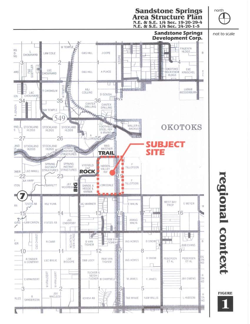
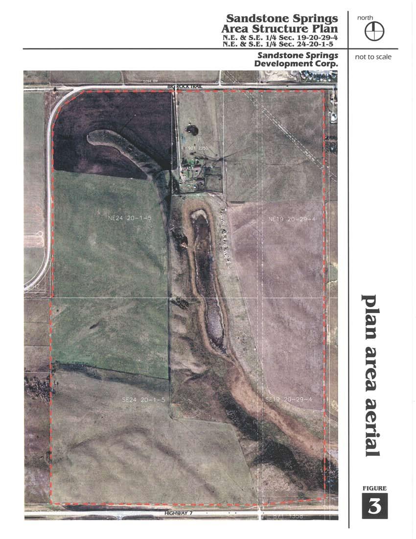
6 2.0 THE PLAN AREA 2.1 Regional/Municipal Context Sandstone Springs is approximately 162 hectares (420 acres) in size and is located on the south and east side of Big Rock Trail immediately southwest of the Town of Okotoks. Highway 7 forms the Plan Area s southern boundary with existing acreage development taking place on the other side of the highway. and southeast portion of the site. Sloped terrains surround the wetland to the east and west giving it a well defined elongated shape. East and northeast facing slopes contain natural springs that feed water into the wetland. These slopes also include small patches of Aspen. The west and southwest facing slopes support dry grasslands. Figure 1 illustrates the regional context of the Plan Area. 2.2 Definition of the Plan Area As illustrated on Figure 2, the Plan Area consists of: ¾ ¾ ¾ ¾ ¾ NE¼ Section 24, Twp. 20, Rge. 1, W5M consisting of acres SE½ Section 24, Twp. 20, Rge. 1, W5M consisting of 160 acres Fractional Section 19, Twp. 20, Rge. 29, W5M consisting of acres Block 1, Plan consisting of acres An undeveloped road allowance consisting of 7.98 acres 2.3 General Physical Description and Area Land Uses The defining feature of the Plan Area is the large wetland located in the central A biophysical analysis of the wetland (included in Appendix A) was conducted in late 2005 and early This analysis divided the wetland into two sections: the north and south sections. The north section is characterized by open water where sparse bulrush plants are embedded in the shallow waters around the edge of this section of the wetland. The southern section consists largely of grasses and sedges with there being no significant amounts of standing water evident at the time of the analysis. Above the wetland and the slopes, some of which contain exposed sandstone ridges, is a flat to gently undulating upland plain. The majority of this portion of the site has been cultivated and grazed and contains little natural vegetation. Figure 3 provides an aerial view of the site. 4
7 5
8 6
9 7

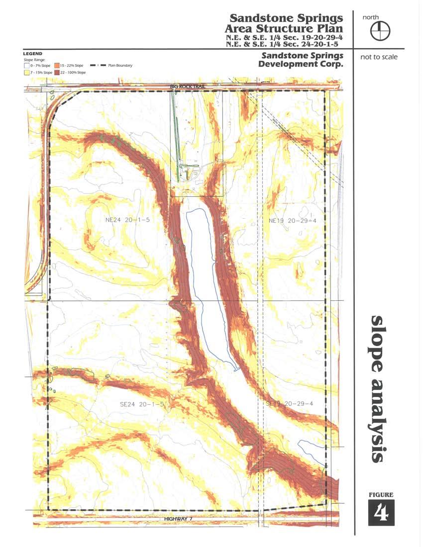
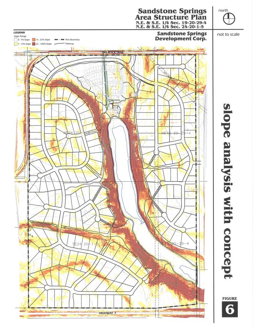
10 Figure 4 illustrates the varied terrain on site ranging from a high point of 1137 m at the southwest corner of the site to a low point of 1083 m at the wetland. The existing farm house and corresponding out-buildings are located at the north end of the wetland with driveway access off Big Rock Trail. The farm house is orientated to the south to capture dramatic views of the wetland down the valley between the sandstone ridges. More than 300 cattle currently graze the subject lands. 8
11 9


12 3.0 PLAN OBJECTIVES The objective of the Sandstone Springs Area Structure Plan is to provide the policy and design framework to facilitate the development of a unique residential community that caters to the diverse needs and lifestyle choices of its future inhabitants while remaining sensitive to the inherent natural qualities of the site. ¾ ¾ To create a residential community that includes amenities that will meet the recreational needs of future residents. To tie the scope of the development to the sustainable domestic water supply. In support of this objective, the plan identifies a number of guiding principles and design objectives that have been used to guide the conceptual development of Sandstone Springs. These principles and design objectives were derived from a solid understanding of the natural qualities and characteristics of the land itself. Once established, they were used as touch stones that were revisited throughout the design process to ensure the end concept was consistent with the key elements that make the site unique. 3.1 Guiding Principles 3.2 Design Objectives The design objectives are a further refinement of the guiding principles and serve as the basis for the evolution of the concept plan. ¾ ¾ ¾ To maintain and enhance the existing wetlands and integrate them into the design concept so that they form an integral part of the development. To respect the natural land form by integrating the development into the existing landscape. To create a residential community that incorporates a variety of residential parcel sizes that will cater to individuals at different stages of life with diverse lifestyle objectives and income levels Patterns of Development ¾ To ensure the concept for Sandstone Springs is consistent with existing municipal and provincial policies and standards. ¾ To sensitively integrate the concept into the natural land form, utilizing those portions of the site best suited to accommodate development and protecting those areas that are environmentally significant or contain development constraints. 10

13 ¾ To create natural breaks in the development in order to facilitate pedestrian access, and to retain and reinforce dramatic views into the valley. ¾ To reinforce the rural character of the area by preserving large contiguous areas of open space visible from Big Rock Trail and Highway 7. ¾ To concentrate development on the plateaus away from the sensitive wetland areas. ¾ To provide a range of parcel sizes that will result in a diverse residential community catering to different life stages, income levels and lifestyles. ¾ To provide residential design standards that strive to establish a strong identity for the community Environmental Preservation ¾ To protect and, where appropriate, enhance the natural wetland. To design and construct pathways, open spaces and other recreational amenities that respect the important habitat function of the wetland. ¾ To protect and enhance the natural springs and other significant drainage courses that flow into the wetlands. ¾ To ensure the long term sustainability of the wetland, natural springs and groundwater resources. ¾ To utilize the natural resources in such a way that residents and the public are able to view, understand, appreciate, and respect the unique natural features within the Plan Area Residential Development ¾ To provide a variety of lot sizes to meet the diverse needs of future residents. ¾ To provide smaller-scale housing forms within close proximity to area amenities that cater to those wishing to live in a rural environment, but may not wish to maintain a large yard Recreation ¾ To encourage recreational amenities that are compatible with and complementary to the surrounding area. ¾ To provide amenities that meet the recreational needs of residents and the public. ¾ To provide a comprehensive community pathway system that allows pedestrians to enjoy the site s natural amenities. ¾ To provide areas for both active and passive recreation through the development of communal facilities 11

14 and the provision of municipal and environmental reserves Logical Growth Infrastructure ¾ To provide the infrastructure necessary to efficiently service the land uses within the Plan Area. ¾ To ensure the infrastructure provided will accommodate the long term needs of the community in a sustainable manner. ¾ To provide road and pathway systems that ensure the safe, efficient and logical movement of vehicles and pedestrians. ¾ To establish a phasing program that follows a logical progression and encourages the efficient extension of on-site services and recreational amenities. 12


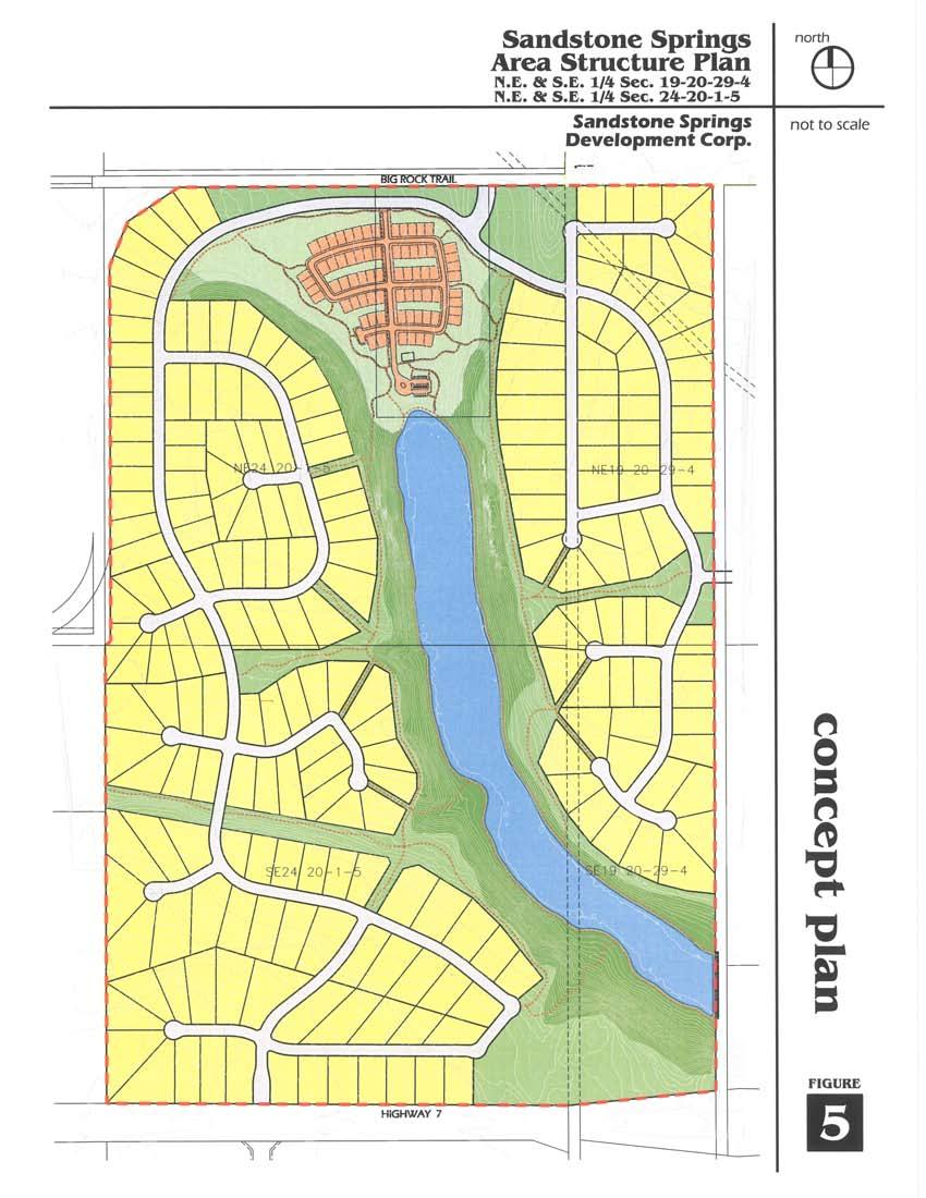
15 4.0 PLAN POLICIES The following policies establish the framework that will guide the future development of Sandstone Springs. Policy areas have been established that address all key aspects of the project. The policies are intended to provide the developer and the Municipal District of Foothills No. 31 with clear statements that will serve to provide certainty on how the Plan Area will be developed in the future. 4.1 The Plan Concept Sandstone Springs will be a comprehensively planned, integrated, environmentally sensitive residential community. It will contain up to 300 residential lots to be subdivided and developed in accordance with the provisions of the Municipal Development Plan, Land Use Bylaw and this Area Structure Plan. Policy 4.1.1: Subdivision shall generally be in accordance with Figure 5; however, there may be variations in the number of lots and lot configurations. 4.2 Land Use Components Sandstone Springs will be a residential community that offers both bareland condominium and fee simple tenure options. The residential area adjacent to and at the north end of the wetland, consisting of approximately 70 units, will be developed as a bareland condominium. Each residential unit will be located on 5,000 to 7,000 square foot lots. Residential lots, ranging in size from 0.8 acres to 1.99 acres, will be developed on the plateau lands adjacent to the ridge above the wetland. The ridge above the wetland and the wetland itself will be protected while allowing the integration of these areas into the overall concept. Recreational amenities, including pathways, viewing areas, and the community recreation facility, will be located within close proximity to the wetland thereby reinforcing the importance of the wetland as the focal point within the community. A community social and recreation facility is centrally located within this area to facilitate easy pedestrian access. The community social and recreation facility will provide meeting rooms, a library, exercise room, and swimming pool. Maintenance of the amenities and natural area will be done by a homeowners association that will be established by the developer. 13

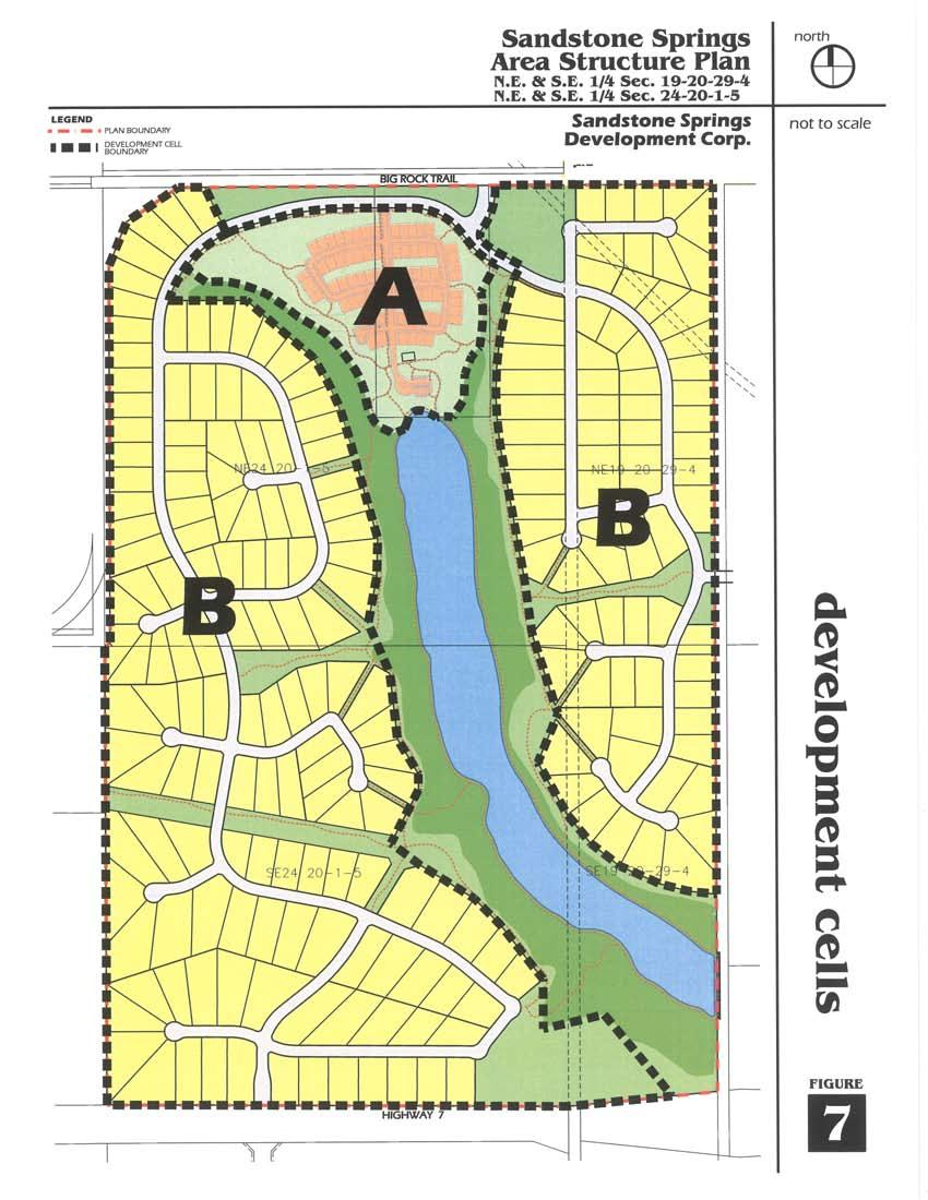
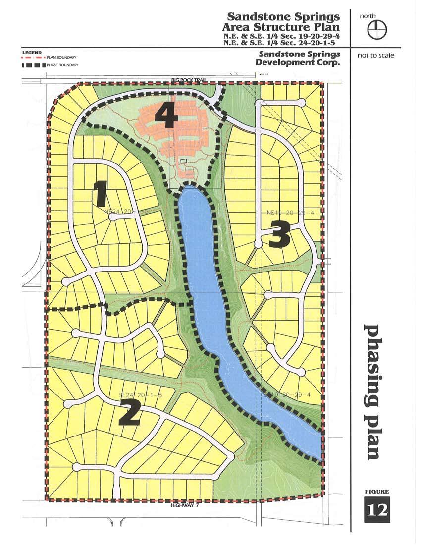
16 Acreage residential units, ranging in size from 0.8 acres to 1.99 acres, will be located on the east and west slopes of the Plan Area in such a way so as to maximize views of the wetland and surrounding natural landscape. As noted earlier, these parcels will be developed on a fee simple basis. The entire community is linked by an extensive pathway system. The pathways will be of a firm surface to facilitate greater accessibility to this area and will link the residents on the plateau to the wetland thereby fostering a sense of community by providing interpretive and educational opportunities. Figure 5 illustrates the concept plan and Figure 6 demonstrates how Sandstone Springs is designed to optimize the site topography while being sensitive to the natural features. It is an integrated recreational and residential community that is comprehensive in its scope. Policies pertaining to residential development within the subject lands are described below Residential Policies The residential development shall conform to Section 14 of the Foothills Land Use Bylaw including the general and specific setback requirements from highways, property lines and internal roads. Where the Foothills Land Use Bylaw does not contain acceptable provisions to adequately accommodate the residential development, a new direct control bylaw may be prepared to ensure the provisions of this Plan are addressed. The residential development shall contain up to three hundred (300) residential units. Should additional units be proposed, an amendment to this Plan shall be required. Residential development in Cell A, as illustrated on Figure 7, will consist of up to 70 lots with a minimum lot area of 5,000 square feet and a maximum lot area of 7,000 square feet. Residential development in Cell B, consisting of up to 230 lots, as illustrated on Figure 7, may occur on lots with a minimum area of 0.8 acres and a maximum parcel area of 1.99 acres. Residential development should be integrated into the natural landscape so as to minimize any impact on the natural landscape and to enhance the visual quality of the community. 14
17 15
18 16
19 17


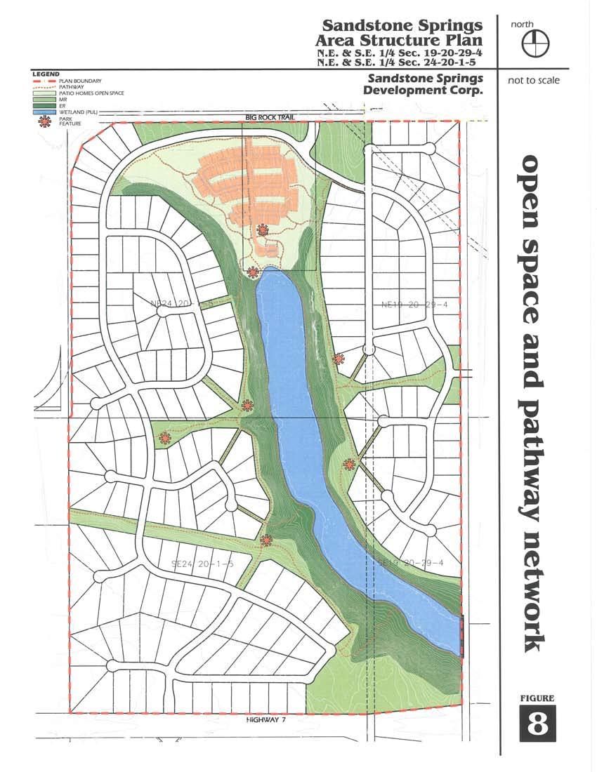
20 4.3 Open Space The Sandstone Springs Area Structure Plan establishes a number of open space areas that are distributed throughout the community. The open spaces will provide residents with both active and passive recreational opportunities. In addition, the A 10 acre park, located in the southeast corner of the community, will also be dedicated as Municipal Reserve. It is adjacent to the ridge that overlooks the southern portion of the wetland and is linked via the trail network to the balance of the Municipal Reserve and the wetland below. This 10 acre park would be suitable for a school site should it be deemed necessary. In the interim, the park could be used for active and passive recreation. An off-street parking area would also be constructed to allow the public access to the Municipal Reserve and pathway system. open space network will serve to protect environmentally sensitive areas. The open spaces provided within the community include the following Municipal Reserve The Municipal Government Act stipulates that up to 10% of the developable area may be dedicated as Municipal Reserve. Figure 8 illustrates the location and extent of the Municipal Reserve that is being provided. Land will be dedicated at the entrance to Sandstone Springs in order to locate entrance features and to create a green space between Big Rock Trail and the central portion of the community. Policy : Figure 8 illustrates the area that shall be dedicated as Municipal reserve. Policy : A homeowners association shall be established by the developer to manage and maintain all lands dedicated as Municipal Reserve. 18
21 19

22 4.3.2 Patio Home Open Space Pathways Within the area that is to accommodate the patio homes, there will be an open space system geared to providing residents with recreational opportunities. The open space in this area will be part of the condominium association that will be created for this area. Included will be an internal trail system linking to the overall network, a recreation building catering to the residents of the patio homes, and natural spaces that surround this development cell. In addition, a small parking lot will be constructed to allow all residents of Sandstone Springs to access the wetlands and the overall community trail system. A series of trails will be created that will provide pedestrian linkages throughout the community. The lower trail system will run along the wetland and will interpret information on the creation, value and nature of the wetland. Policy : Figure 8 illustrates the area that is to remain as patio homes open space. Policy : A condominium association shall be incorporated by the developer to manage and maintain all lands and facilities shown as patio home open space. Policy : The parking lot illustrated on Figure 8 and contained within the patio homes open space will be maintained through an agreement, established by the developer, between the condominium association and the homeowners association. Another trail system will be created along the ridge that overlooks the wetland. These two trail systems will be linked providing a network that is over 8 kilometres in length. The overall network will be hard surfaced to provide all residents with easy access to the entire trail system. Policy : A pathway system, as illustrated on Figure 8, shall be constructed at the developer s expense. Policy : The pathway system shall be hard surfaced and constructed to a standard acceptable to the Municipal District of Foothills. Policy : A homeowners association shall be established by the developer to manage and maintain 20
23 the pathway system outside the patio home open space. Policy : Within the patio home open space, the pathways shall be managed and maintained by the condominium association Environmental Reserve The intent of the Environmental Reserve is to protect lands that are environmentally sensitive from any potential negative impacts associated with incompatible land uses and to preserve the natural integrity of unique land forms within the Plan Area. The steep slopes enclosing the wetland, the sandstone outcropping and two historical sites have been designated as Environmental Reserve. Policy : Figure 8 illustrates the land within the Plan Area that shall be dedicated as Environmental Reserve. Policy : Land dedicated as Environmental Reserve shall remain in its natural state Wetland cannot only be maintained, but enhanced by carrying out improvements as described below. In carrying out the improvements, the natural qualities of the wetland can be improved and it can also serve to manage stormwater and act as a reservoir for irrigation water. Presently, the wetland has two distinct parts: the northern portion and southern portion. The northern portion is the deeper of the two and tends to retain water on a more permanent basis. As such, this part of the wetland supports diverse wetland plant species within the shallow water around its outer edge. The southern portion of the wetland does not contain standing water and, as such, it does not currently support typical wetland plant species. It is proposed to enhance the wetland so that the southern portion is capable of accommodating the same range of wetland plant species as currently occurs in the northern portion. This would be done by deepening the central portions of the northern and southern parts of the wetland to the same depth. In addition, plant species would be introduced to the southern portion and the existing plants that occupy the outer edge of the northern wetland would be maintained. The wetland occupies the central portion of the Plan Area. It has been the subject of a biophysical analysis that examined its natural features, its biological makeup and the potential to sensitively utilize the area to manage stormwater runoff. It was concluded that the existing wetland In order to carry out the enhancements, additional water will need to be retained. This will be done by constructing a small berm along the southern edge of the wetland. Included within the berm will be a control structure that will permit the outflow of post-development flows. 21

24 An application has been made to Alberta Environment that details the proposed wetland enhancement. Policy : Any modification to the existing wetland shall be subject to the approval of Alberta Environment and the Municipal District of Foothills. Policy : The wetland, as illustrated on Figure 8, shall be dedicated to the Municipal District of Foothills as a Public Utility Lot. Policy : A homeowners association shall be established by the developer to manage and maintain the wetland as a Public Utility Lot. The open space provided within Sandstone Springs is summarized below. Type of Open Space Municipal Reserve (including pathways) Patio Home Open Space Environmental Reserve Wetland Total Area (Acres) acres acres acres acres acres This accounts for 33% of the total Plan Area with the Municipal Reserve dedication accounting for 12% of the developable area. 4.4 Servicing Sanitary Sewer Service Sanitary sewer service will be provided through advanced on-site sewage treatment (such as Advantex) and ground disposal. Within Cell A, a collection system will be installed and conveyed to a centrally located treatment and disposal system. For development within Cell B, either a collection system with appropriately located disposal sites, or individual systems located on each parcel will a provide a high level of treatment and disposal. A shallow subsurface analysis was conducted in February 2006, the results of which are included in Appendix B. Once installed, the systems will be monitored and maintained by a utility company established for the prime purpose of operating the sanitary sewer facilities and the domestic water supply as described in Section This utility company will be responsible for ensuring that the sanitary sewer services are adequately maintained and operate within parameters established by Alberta Environment. 22
25 The following policies shall apply to the installation and operation of the sanitary sewer system. Policy : Prior to any subdivision approval, the developer shall establish a utility company that will be responsible for the installation, monitoring and maintenance of the sanitary sewer collection treatment and disposal systems. In establishing the utility system, the developer shall identify the means whereby charges will be applied to each parcel to ensure the utility has sufficient funds to install, monitor and maintain the sanitary sewer systems on an ongoing basis. Policy : Prior to any subdivision approval, the developer shall provide to the Municipal District of Foothills, confirmation of the type of advanced onsite treatment system to be used, and whether a collective system will be installed in Cell B. Policy : Installation of the sanitary sewer systems shall be the responsibility of the developer. The location of the collection (where applicable) treatment and disposal systems shall be identified prior to the issuance of a building permit. Policy : The design and operational parameters of each sanitary sewerage system shall be consistent with those established by Alberta Environment and the Municipal District of Foothills Water Supply Domestic water will be provided by a series of groundwater wells. An analysis of the groundwater supply was conducted by Groundwater Exploration and Research in November This analysis examined the supply and identified the groundwater reserve and prescribed a sustainable yield. A copy of the groundwater analysis is included as Appendix C. The domestic water system consists of a series of groundwater wells, treatment facility and distribution mains. Each parcel will be supplied with domestic water from this system. Figure 9 outlines the proposed water system. Water required for irrigation will be collected and distributed using a separate water system. This water will not require the same level of treatment as domestic water thus reducing water treatment and maintenance costs. The irrigation system will be supplied from the rainfall runoff which is directed to the wetland on the site. Separate irrigation supply lines that run parallel to the domestic lines will be provided to each lot, thus reducing the demand on the domestic water system. 23
26 24

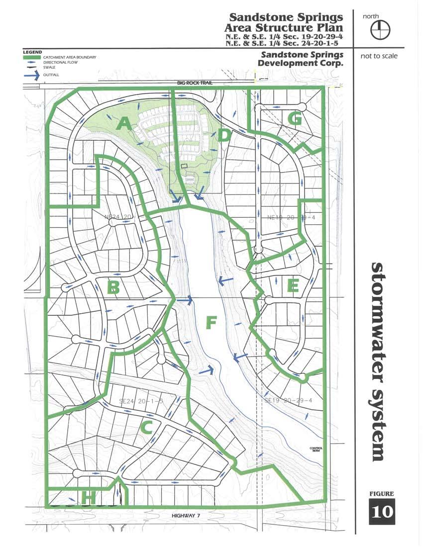
27 The water systems will be installed, operated and maintained by a utility company established by the developer prior to subdivision approval. Both the domestic and irrigation systems will include water meters at each unit. The following policies shall apply to the water supply: Policy : The utility company established by the developer will be responsible for the installation, operation and maintenance of the water system. Policy : The developer shall register the necessary easements and rights-ofway for the water system at the subdivision stage. If Council requires, access to the facilities and related infrastructure, easements, and rightsof-way will be granted for emergency purposes. Policy : The necessary water evaluation reports will be completed and submitted to the Municipal District of Foothills No. 31 and the proper licensing and approvals obtained from Alberta Environment. Policy : The proper licensing for groundwater will be obtained to the satisfaction of the Municipal District of Foothills No. 31 and Alberta Environment prior to installation Stormwater Management A stormwater management plan that addresses the stormwater solutions for the Plan Areas is included as Appendix D. It notes the stormwater runoff within the Plan Area c u r r e n t l y flows toward the wetland located in the central portion of the site. These pre-development flows are accommodated through natural depressions and overland channels that exist throughout the Plan Area. The design of Sandstone Springs utilizes these natural drainage channels to convey stormwater runoff toward the wetland. Figure 10 illustrates the catchment areas and drainage channels for Sandstone Springs. The stormwater management for the Plan Area will maintain the wetland and its current function as a stormwater retention pond. In order to ensure stormwater quantity is maintained to a high quality, natural treatment facilities will be included in the overall stormwater management. Best Management Practices will be implemented to ensure the quantity and quality of stormwater flow entering the wetland will be at pre-development levels. 25
28 26

29 The policies associated with stormwater management are as follows: are proposed including one off of Big Rock Trail and one off of Highway 7. Policy : The quality and quantity of stormwater runoff within the Plan Area will be maintained at predevelopment levels. Policy : Stormwater runoff from roads, driveways and roofs shall be conveyed using natural drainage channels and roadside ditches. Policy : Best Management Practices shall be implemented throughout Sandstone Springs. These may include grassed roadside ditches and swales which can minimize erosion and remove sediment, end treatment measures, and minimal lot grading to reduce runoff volume from developed parcels. Policy : The developer shall obtain all licenses required by Alberta Environment to divert surface runoff and to utilize the wetland as a stormwater retention facility. 4.5 Transportation An internal road system has been designed to provide efficient access and circulation throughout Sandstone Springs. These new access points in existing roadways A transportation impact study, provided under separate cover, was completed in order to quantify the traffic generated by Sandstone Springs and to examine the effect of any new traffic on adjacent roadways and new intersections. The major components of the road network in the vicinity of Sandstone Springs are described below and illustrated on Figure 11. Southridge Drive / Highway 2A is a divided 4-lane road that is part of the provincial highway system and is classified as a major arterial within the Town of Okotoks. The highway serves as the major northsouth route through the centre of Okotoks providing access for residents of the Town and the Municipal District to the City of Calgary. Highway 2A is the only crossing of the Sheep River serving both local and non-local travel within the town. The intersection with Big Rock Trail includes exclusive left turn lanes and channelized right turns on all approaches. The intersection is signalized with pedestrian crossings on all approaches. 27
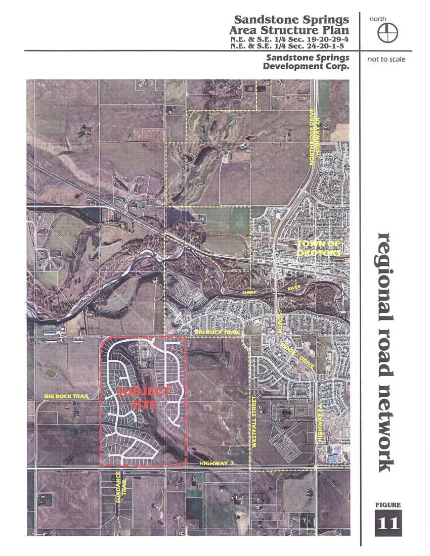
30 28

31 Southridge Drive carries nearly 20,000 vehicles per day. Highway 7 is an undivided 2-lane road that is also part of the provincial highway system and is classified as a major arterial. Highway 7 is a major east-west highway traversing the southern edge of the Town and providing access to the Turner Valley and Black Diamond communities to the west. It also provides a link to Southridge Drive to the east. with Highway 7 is stop controlled with 5.0 metre lane widths. Daily traffic volumes do not exceed 1,000 vehicles per day. The T-intersection with Sundance Trail, located opposite to the site, provides a right turn deceleration and acceleration lane for traffic turning to and from Sundance Trail. Highway 7 carries nearly 3,000 vehicles per day. Big Rock Trail is a 2-lane divided collector road for several hundred metres. Further to the west the roadway narrows to a 2 lane undivided cross-section. Approximately 2 kilometres west of Southridge Drive, Big Rock Trail completes the first of three 90 degree turns spaced approximately 800 metres apart before intersecting Highway 7. It carries between 2,000 and 5,000 vehicles per day and provides access to the residential districts of Hunter s Gate and Sheep River Ridge, southwest of the Sheep River. It also serves as an alternative route connecting to Highway 7. Sundance Trail is a 2-lane local road that accesses Highway 7 and provides entry into a 30 single family unit development south of the subject site. The T-intersection Pacer Park is a 7.0 metre wide gravel residential access for a farm home along Big Rock Trail. Daily traffic volumes are negligible. Figure 11 outlines the regional road network. Based on the findings of the traffic impact study, no improvements are required to Big Rock Trail. The intersection of Highway 7 and the southern access point will require a minor upgrade to permit left hand turning movements in and out of Sandstone Springs, and acceleration and deceleration lanes for right hand movements. The policies associated with transportation include: Policy 4.5.1: Vehicular access to the Plan Area shall be from internal roads. Policy 4.5.2: Internal access and roadways required to service the development area shall be designed in 29
32 accordance with municipal standards, but may be modified in consultation with the Municipal District of Foothills No. 31. Policy 4.5.3: All internal roadways shall be constructed at the developer s expense. Policy 4.5.4: Roadways within Cell A, as outlined on Figure 7, shall be developed as part of a bareland condominium. As such, the developer shall be responsible for the construction of the internal road system, and the liability and maintenance will be the responsibility of the condominium association. Policy 4.5.5: At his sole expense, the developer shall upgrade the Highway 7/southern access intersection to the satisfaction of Alberta Transportation and Infrastructure and the Municipal District of Foothills No. 31. Policy 4.5.6: The Highway 7/south access intersection shall be upgraded in conjunction with the initial development of the Plan Area. As per a road use agreement executed between the developer and the Municipal District of Foothills No. 31, construction traffic shall use the Highway 7/south access intersection to access the Plan Area. Construction traffic shall not use the Big Rock Trail/north access intersection. Policy 4.5.7: The developer shall be responsible to construct or make contributions toward road improvement fees for external roads that are required to accommodate traffic associated with Sandstone Springs. Policy 4.5.8: The design and improvements of all external roads shall meet all requirements and conditions set forth by Alberta Infrastructure and Transportation, and the Municipal District of Foothills No. 44. Policy 4.5.9: As this sole expense, the developer shall upgrade Big Rock Trail where it intersects with the proposed access into Sandstone Springs. The design of the intersection shall be to the satisfaction of the Municipal District of Foothills No. 31. Policy : Prior to subdivision approval, the developer and the Municipal District of Foothills No. 31 shall enter into an agree ment that specifies the amount and timing of the contribution to be applied to off-site road improvements. 30
33 4.6 Historical Resources Assessment An Historical Resources Assessment was completed for the Plan Area. Two sites of potential significance were identified. One is located on the western side of the wetland in the central portion of the Plan Area. The second site is located on the eastern side of the wetland. Both have been included in the Environmental Reserve as per the recommendations of the Historical Resources Assessment. The Historical Resources Assessment is provided in Appendix E. 4.7 Concept Plan Statistical Summary The following provides a breakdown of the statistics associated with the concept plan: Hectares Acres Residential Patio Homes Roads Municipal Reserve* Environmental Reserve Wetland (PUL) Total Plan Area ** * includes 0.6 hectares (1.48 acres) of road allowance ** includes 3.23 hectares (7.98 acres) of road allowance 4.8 Phasing Sandstone Springs has been designed as an integrated, comprehensively planned residential community. As such, a single application for land use redesignation for the entire site will be made. However, the subdivision of the site will occur in phases that allow for the logical extension of services, roadways and pathways. Policy 4.8.1: A single redesignation application shall be made that addresses the future land use and development of the entire site. Policy 4.8.2: A subdivision of the site may be done in phases in conjunction with the extension of services and the construction of the internal road and pathway systems and as generally illustrated on Figure 12. Policy 4.8.3: The phasing plan as illustrated on Figure 12 is intended to provide a general indication on how Sandstone Springs will develop over time. Phasing of development may proceed differently than illustrated on Figure 12 without an amendment to this Plan. Policy 4.8.4: Further to Policies and 4.5.6, the Highway 7 and Big Rock Trail intersections shall be upgraded as part of Phase 1. Further a haul road from Highway 7 shall be constructed as part of Phase 1 to accommodate all construction related traffic. 31
34 32


35 5.0 IMPLEMENTATION The provisions of this Area Structure Plan will be implemented through the redesignation and subdivision of the site. In addition, provisions will be put in place that ensure the future development of the site is consistent with Municipal District of Foothills No. 31 standards. The following sets out implementation policies relative to Sandstone Springs: Policy 5.0.1: All development shall conform to the provisions of the Municipal District of Foothills No. 31 Land Use Bylaw. Policy 5.0.2: All subdivision and development shall be in conformity with the standards established by the Municipal District of Foothills No. 31. Policy 5.0.3: Development approval shall be conditional upon a signed Development Agreement between the developer and the Municipal District of Foothills No. 31. Policy 5.0.4: Internal roadways within Cell B, as outlined on Figure 7, shall be constructed to municipal standards at the sole expense of the developer. Upon issuance of a Final Acceptance Certificate, the maintenance of the internal roads shall be the responsibility of the Municipal District of Foothills No. 31. Policy 5.0.5: Maintenance and any liability associated with all internal roadways and amenities within Cell A, as outlined on Figure 7, shall be the responsibility of the bareland condominium association. Policy 5.0.6: The developer shall be responsible for establishment of a Homeowners Association who will be responsible for operation, maintenance and any liability associated with the Municipal Reserve, pathways, any Environmental Reserve, and any public utility lots. 33
36 APPENDIX A (Submitted under separate cover)
37 APPENDIX B (Submitted under separate cover)
38 APPENDIX C (Submitted under separate cover)
39 APPENDIX D (Submitted under separate cover)
40 APPENDIX E (Submitted under separate cover)
41
Leduc Industrial Outline Plan SE W4
 Leduc Industrial Outline Plan SE 1-50-25-W4 Within the North Leduc Industrial ASP Prepared for: Leduc Energy Park Ltd. Prepared by: Stantec Consulting Ltd. File No. 1161 104655 V5 Table of Contents 1.0
City of Grande Prairie Development Services Department KENNEDY DEVELOPMENTS LTD. OUTLINE PLAN OP-09-01
 City of Grande Prairie Development Services Department KENNEDY DEVELOPMENTS LTD. OUTLINE PLAN OP-09-01 July 27, 2009 TABLE OF CONTENTS 1.0 Introduction... 1 1.1 Plan Area Location & Context... 1 1.2 Ownership
BYLAW C A Bylaw of Rocky View County to amend Land Use Bylaw C
 BYLAW C-7720-2017 A Bylaw of Rocky View County to amend Land Use Bylaw C-4841-97. The Council of Rocky View County enacts as follows: PART 1 TITLE This Bylaw shall be known as Bylaw C-7720-2017. PART 2
Land Use Amendment in Southwood (Ward 11) at and Elbow Drive SW, LOC
 at and Elbow Drive SW, LOC") 2018 November 15 Page 1 of 10 EXECUTIVE SUMMARY This land use amendment application was submitted by Rick Balbi Architect on 2017 August 31 on behalf of Sable Developments Ltd, and with authorization from
2018 November 15 Page 1 of 10 EXECUTIVE SUMMARY This land use amendment application was submitted by Rick Balbi Architect on 2017 August 31 on behalf of Sable Developments Ltd, and with authorization from
ADMINISTRATION RECOMMENDATION 2016 November 03. That Calgary Planning Commission recommends APPROVAL of the proposed Land Use Amendment.
 Page 1 of 12 EXECUTIVE SUMMARY This Land Use Amendment application covers an area of 75.76 hectares ± (187.20 acres ±) located in northeast Calgary, bound by Stoney Trail NE to the north, 128 Avenue NE
OP Council Resolution June 16, Planning and Development Services
 OP-08-01 Council Resolution June 16, 2008 Planning and Development Services Kingsgate Landing Outline Plan Table of Contents 1.0 Introduction 1 1.1 Purpose of Plan 1 1.2 Plan Area Location 1 1.3 Ownership
WEST HILL BUSINESS PARK AREA STRUCTURE PLAN
 MUNICIPAL DISTRICT OF PEACE NO. 135 WEST HILL BUSINESS PARK AREA STRUCTURE PLAN Prepared by: TABLE OF CONTENTS 1.0 Introduction... 1 1.1 Purpose of Plan........ 1 1.2 Plan Area..... 1 1.3 Existing Conditions...
S o u t h C e n t r a l O u t l i n e P l a n. Leduc Business Park. North Leduc Industrial Area Structure Plan C it y of Led u c.
 Leduc Business Park North Leduc Industrial Area Structure Plan C it y of Led u c Prepared for Farm Air Properties Inc. January, 2007 Table of Contents Page Number 1.0 Purpose of Plan and Definition of
LAND USE AMENDMENT CORNERSTONE (WARD 3) 60 STREET NE AND COUNTRY HILLS BOULEVARD NE MAP 26NE BYLAW 22D2017
 60 STREET NE AND COUNTRY HILLS BOULEVARD NE MAP 26NE BYLAW 22D2017") Page 1 of 14 EXECUTIVE SUMMARY This Land Use Amendment application covers an area of 43.76 hectares ± (108.14 acres ±) located in northeast Calgary, bound by Country Hills Boulevard NE to the south and
Page 1 of 14 EXECUTIVE SUMMARY This Land Use Amendment application covers an area of 43.76 hectares ± (108.14 acres ±) located in northeast Calgary, bound by Country Hills Boulevard NE to the south and
LAND USE AMENDMENT CORNERSTONE (WARD 3) COUNTRY HILLS BOULEVARD AND STONEY TRAIL NE BYLAW 9D2017
 COUNTRY HILLS BOULEVARD AND STONEY TRAIL NE BYLAW 9D2017") Page 1 of 12 EXECUTIVE SUMMARY This Land Use Amendment application covers an area of 54.92 hectares ± (135.71 acres ±) located in northeast Calgary, bound by Country Hills Boulevard NE to the north and
Page 1 of 12 EXECUTIVE SUMMARY This Land Use Amendment application covers an area of 54.92 hectares ± (135.71 acres ±) located in northeast Calgary, bound by Country Hills Boulevard NE to the north and
C ity of Grande Prairie Development Services Department
 C ity of Grande Prairie Development Services Department FAIRWAY DEVELOPMENT OUTLINE PLAN OP 08 09 Approved April 6, 2009 Prepared by: Focus Corporation Table of Contents 1.0. Introduction 2 3 1.1. Plan
Red Fox Commercial Outline Plan
 Red Fox Commercial Outline Plan City of Cold Lake, Alberta Prepared by Durrance Projects Ltd and Ross W. Sharp & Associates Ltd October 2014 Rupert 1 Table of Contents 1. PURPOSE...3 1.1. Location...4
The Uplands Area Structure Plan. City of Cold Lake, NE & SE W4
 City of Cold Lake, NE & SE 13-63-2-W4 July 2009 1 Contents 1 Background information... 1 1.1 Foreword... 1 1.2 Purpose... 1 1.3 Plan Area and Location... 1 1.4 Ownership... 2 2 Factors Influencing Development...
Palisades Outline Plan
 NE ¼ 25 36 28 W4 Town of Penhold Approved August 13, 2012 Contents Figures & Tables... 2 Introduction... 1 Overview... 1 Purpose... 1 Development Area... 3 Ownership... 3 Topography... 3 Existing & Surrounding
ROAD CLOSURE AND LAND USE AMENDMENT SILVER SPRINGS (WARD 1) NORTHEAST OF NOSEHILL DRIVE NW AND SILVER SPRINGS ROAD NW BYLAWS 2C2018 AND 29D2018
 NORTHEAST OF NOSEHILL DRIVE NW AND SILVER SPRINGS ROAD NW BYLAWS 2C2018 AND 29D2018") Page 1 of 19 EXECUTIVE SUMMARY This application proposes redesignating two parcels in the community of Silver Springs from Special Purpose Future Urban Development (S-FUD) District and undesignated road
Page 1 of 19 EXECUTIVE SUMMARY This application proposes redesignating two parcels in the community of Silver Springs from Special Purpose Future Urban Development (S-FUD) District and undesignated road
City of Grande Prairie Development Services Department
 City of Grande Prairie Development Services Department ROYAL OAKS NORTH OUTLINE PLAN OP-07-03 NW 35-71-6 W6M May 7, 2007 Royal Oaks North Outline Plan TABLE OF CONTENTS 1.0 INTRODUCTION........ 3 1.1 Purpose
North Oakville East Parks Facilities Distribution Plan. November, 2009
 North Oakville East November, 2009 POLICY CONTEXT 1) Purpose a) The purpose of this document is to be a guide for the location, configuration, design and development of the parks system for the North Oakville
ADMINISTRATION RECOMMENDATION(S) 2016 November 03. That Calgary Planning Commission recommends APPROVAL of the proposed Land Use Amendment.
 2016 November 03. That Calgary Planning Commission recommends APPROVAL of the proposed Land Use Amendment.") Page 1 of 7 EXECUTIVE SUMMARY This Land Use Amendment application seeks to redesignate a portion of the parcel from Industrial General (I-G) District to Special Purpose City and Regional Infrastructure
Page 1 of 7 EXECUTIVE SUMMARY This Land Use Amendment application seeks to redesignate a portion of the parcel from Industrial General (I-G) District to Special Purpose City and Regional Infrastructure
GRAYSTONE ESTATES CONCEPTUAL SCHEME
 GRAYSTONE ESTATES CONCEPTUAL SCHEME Bylaw C-5438-2001, Adopted November 6, 2001 MUNICIPAL DISTRICT OF ROCKY VIEW NO. 44 Department of Planning and Development TABLE OF CONTENTS 1.0 INTRODUCTION 5 1.1 Conceptual
Bylaw C-1262 Adopted February 6, Planning and Development Department
 Bylaw C-1262 Adopted February 6, 2012 Planning and Development Department CITY OF GRANDE PRAIRIE BYLAW C-1262 A Bylaw to adopt the Brookfield Neighbourhood Outline Plan THE MUNICIPAL COUNCIL OF THE CITY
CENTRAL PARK MAJOR AREA STRUCTURE PLAN. Bylaw No. 2017/30, Adopted February 20, P a g e
 CENTRAL PARK MAJOR AREA STRUCTURE PLAN Bylaw No. 2017/30, Adopted February 20, 2018 1 P a g e Table of Contents 1.0 Introduction 4 1.1 Background 4 1.2 Purpose 4 1.3 Location 4 1.4 Planning Process 4
Bylaw C-1186 Adopted November 5, Planning and Development Services
 Bylaw C-1186 Adopted November 5, 2007 Planning and Development Services CITY OF GRANDE PRAIRIE OFFICE CONSOLIDATION BYLAW C-1186 A Bylaw to adopt the Westgate Area Structure Plan (As Amended by Bylaw C-1186-1,
ADMINISTRATION RECOMMENDATION(S) 2017 June 15. That Calgary Planning Commission recommends APPROVAL of the proposed Land Use Amendment.
 2017 June 15. That Calgary Planning Commission recommends APPROVAL of the proposed Land Use Amendment.") Page 1 of 7 EXECUTIVE SUMMARY The proposed land use amendment seeks to redesignate a Special Purpose Future Urban Development (S-FUD) District parcel in Residual Ward 3 Sub Area 3H to Industrial Outdoor
Page 1 of 7 EXECUTIVE SUMMARY The proposed land use amendment seeks to redesignate a Special Purpose Future Urban Development (S-FUD) District parcel in Residual Ward 3 Sub Area 3H to Industrial Outdoor
TABLE OF CONTENTS 1.0 INTRODUCTION GENERAL OBJECTIVES LAND USE DESIGNATIONS, OBJECTIVES AND POLICIES 4
 Schedule I- Redstone Golf Course Resort Area Sector Plan 1 TABLE OF CONTENTS 1.0 INTRODUCTION 3 2.0 GENERAL OBJECTIVES 3 3.0 LAND USE DESIGNATIONS, OBJECTIVES AND POLICIES 4 4.0 TRANSPORTATION AND ROAD
ARTICLE IV: DEVELOPMENT STANDARDS 404 MASTER PLANNING
 IV 13 404 MASTER PLANNING Master Planning through the Site Analysis (Master Planning Site Analysis) or Planned Development (Master Planning Planned Development) is provided to encourage development which
THE CITY OF WINNIPEG BY-LAW NO. 4/2013. A By-law of THE CITY OF WINNIPEG to adopt a Secondary Plan for the Waverley West Southwest Neighbourhood.
 THE CITY OF WINNIPEG BY-LAW NO. 4/2013 A By-law of THE CITY OF WINNIPEG to adopt a Secondary Plan for the Waverley West Southwest Neighbourhood. THE CITY OF WINNIPEG, in Council assembled, enacts as follows:
ADMINISTRATION RECOMMENDATION(S) 2017 February 09. That Calgary Planning Commission recommends APPROVAL of the proposed Land Use Amendment.
 2017 February 09. That Calgary Planning Commission recommends APPROVAL of the proposed Land Use Amendment.") Page 1 of 10 EXECUTIVE SUMMARY This land use amendment application is to accommodate changes to the location of a stormwater retention pond and land use boundaries adjacent to Environmental Reserve in
Page 1 of 10 EXECUTIVE SUMMARY This land use amendment application is to accommodate changes to the location of a stormwater retention pond and land use boundaries adjacent to Environmental Reserve in
9 CITY OF VAUGHAN OFFICIAL PLAN AMENDMENT NO BOCA EAST INVESTMENTS LIMITED
 9 CITY OF VAUGHAN OFFICIAL PLAN AMENDMENT NO. 631 - BOCA EAST INVESTMENTS LIMITED The Planning and Economic Development Committee recommends the adoption of the recommendations contained in the following
A Growing Community Rural Settlement Areas
 Town of Huntsville Official Plan Review - POLICY BACKGROUND PAPER A Growing Community Rural Settlement Areas BACKGROUND: In addition to the fully municipally-serviced Urban Settlement Area and the Hidden
HAMLET OF KINGMAN AREA STRUCTURE PLAN
 HAMLET OF KINGMAN AREA STRUCTURE PLAN Prepared by: Austrom Consulting Ltd. Page 1 of 19 Table of Contents TABLE OF CONTENTS... 2 1. BACKGROUND... 3 1.1 PLAN AREA... 3 1.2 PLAN PURPOSE... 3 1.3 LEGISLATIVE
EXHIBIT B PROJECT NARRATIVE POULSBO MEADOWS
 EXHIBIT B PROJECT NARRATIVE POULSBO MEADOWS Name of Project: Poulsbo Meadows; A Planned Residential Development (PRD)/Plat Applicants Name: PBH Group LLC/Byron Harris PO Box 1010 Silverdale, WA 98038 Description
TABLE OF CONTENTS. Sierra Springs Outline Plan
 Sierra Springs Outline Plan TABLE OF CONTENTS 1. Introduction...3 1.1. Purpose of the Plan... 3 1.2. The Approval Process... 3 1.3. Policy and Legislative Framework... 3 2. Development Area...6 2.1. Location
Bylaw No. B-03/2011 Adopted by Airdrie City Council February 21, 2012
 COOPER S CROSSING STAGE 4 Neighbourhood Structure Plan City of Airdrie WESTMARK HOLDINGS LTD. Bylaw No. B-03/2011 Adopted by Airdrie City Council February 21, 2012 CONSULTANTS: LAND USE PLANNING: Southwell
Master Site Development Plan (MSDP) Rocky View County Campus at Balzac East
 Rocky View County Campus at Balzac East") Master Site Development Plan (MSDP) Rocky View County Campus at Balzac East Balzac East, Alberta July 2009 CONTENTS 1.0 purpose 1 2.0 guiding principles 2 3.0 site description 3 4.0 site analysis and county
Master Site Development Plan (MSDP) Rocky View County Campus at Balzac East Balzac East, Alberta July 2009 CONTENTS 1.0 purpose 1 2.0 guiding principles 2 3.0 site description 3 4.0 site analysis and county
This application has been applied for with support of an Outline Plan to provide the technical details for the site s development.
 Page 1 of 13 EXECUTIVE SUMMARY This application consists of a Land Use Amendment application proposing redesignation from Special Purpose Future Urban Development (S-FUD) District to an assortment of multiresidential,
Town of Portola Valley General Plan. Nathhorst Triangle Area Plan
 Town of Portola Valley General Plan Amended December 10, 1997 Table of Contents Introduction... 1 Planning Area... 1 Objectives... 2 Principles... 2 Standards... 4 Description... 4 Community Commercial...
AREASTRUCTURE PLAN AMENDMENT COCHRANE NORTH
 AREASTRUCTURE PLAN AMENDMENT COCHRANE NORTH In order to implement the vision outlined in the Conceptual Scheme, the following three amendments to the Cochrane North ASP are proposed: 1. Allow commercial
CONCEPTUAL SCHEME FULTON INDUSTRIAL
 CONCEPTUAL SCHEME FULTON INDUSTRIAL Bylaw C-6919-2010 Adopted June 22, 2010 ROCKY VIEW COUNTY BYLAW C-6919-2010 A Bylaw of Rocky View County to adopt a Conceptual Scheme known as the Fulton Industrial
Municipal Development Plan. Summer Village of ROCHON SANDS. Bylaw #241-18
 Municipal Development Plan Summer Village of ROCHON SANDS Bylaw #241-18 TABLE OF CONTENTS PART ONE: BACKGROUND AND PURPOSE 3 SECTION 1: BACKGROUND 3 SECTION 2: GOALS AND POLICIES 3 PART TWO: PHYSICAL ENVIRONMENT
CottageClub Ghost Lake Conceptual Scheme
 CottageClub Ghost Lake Conceptual Scheme Bylaw C-6585-2007, Adopted January 15, 2008 MUNICIPAL DISTRICT OF ROCKY VIEW NO. 44 Department of Planning and Community Services MUNICIPAL DISTRICT OF ROCKY VIEW
Outline Plan in Belvedere (Ward 9) at Street SE, LOC (OP)
 at Street SE, LOC (OP)") 2018 October 04 Page 1 of 12 EXECUTIVE SUMMARY This outline plan application was submitted by B&A Planning Group on 2016 July 15, on behalf of Tristar Communities Inc. for 50.14 hectares (123.89 acres)
2018 October 04 Page 1 of 12 EXECUTIVE SUMMARY This outline plan application was submitted by B&A Planning Group on 2016 July 15, on behalf of Tristar Communities Inc. for 50.14 hectares (123.89 acres)
AREA STRUCTURE PLAN NE W5M. Adopted by Council September 27, 2010 Bylaw
 AREA STRUCTURE PLAN NE 5-33-1 W5M Adopted by Council September 27, 2010 Bylaw 2010-14 CONTENTS 1.0 Introduction... 3 1.1 Purpose... 3 1.2 Objectives... 3 1.3 Discovery Plains Community Vision... 3 1.3.1
ARTICLE 6: Special and Planned Development Districts
 ARTICLE 6: Special and Planned Development Districts 6-10 Traditional Neighborhood Development (TND) District 6-10.10 Purpose and Intent The Traditional Neighborhood Development (TND) District provides
OFFICE CONSOLIDATION SECONDARY PLAN AREA 22 THE BRAMALEA SOUTH INDUSTRIAL SECONDARY PLAN
 OFFICE CONSOLIDATION SECONDARY PLAN AREA 22 THE BRAMALEA SOUTH INDUSTRIAL SECONDARY PLAN November 2010 EXPLANATORY NOTES (Secondary Plan Area 22) General (pertaining to all secondary plan office consolidations)
Westwind Developments Ltd. PIONEER LANDS AREA STRUCTURE PLAN - PROPOSED AMENDMENT
 FEBRUARY 2013 TABLE OF CONTENTS 1.0 BACKGROUND... 1 1.1 Amendment... 1 2.0 LOCATION & CONTEXT... 2 2.1 Land Ownership... 2 3.0 POLICY CONTEXT... 3 3.1 Municipal Development Plan... 3 3.2 Capital Region
BRIDGES OF LANGDON CONCEPTUAL SCHEME
 BRIDGES OF LANGDON CONCEPTUAL SCHEME Office Consolidation This page contains the history of relevant bylaws affecting this office consolidation. A copy of the original Bylaw and all amending Bylaws can
FORMER CANADIAN FORCES BASE (CFB) ROCKCLIFFE SECONDARY PLAN. Official Plan Amendment XX to the Official Plan for the City of Ottawa
 ROCKCLIFFE SECONDARY PLAN. Official Plan Amendment XX to the Official Plan for the City of Ottawa") FORMER CANADIAN FORCES BASE (CFB) ROCKCLIFFE SECONDARY PLAN Official Plan Amendment XX to the Official Plan for the City of Ottawa 1 INDEX THE STATEMENT OF COMPONENTS PART A THE PREAMBLE PAGE Purpose...
FORMER CANADIAN FORCES BASE (CFB) ROCKCLIFFE SECONDARY PLAN Official Plan Amendment XX to the Official Plan for the City of Ottawa 1 INDEX THE STATEMENT OF COMPONENTS PART A THE PREAMBLE PAGE Purpose...
Planning & Development. Background. Subject Lands
 Planning & Development APPLICATION BRIEFING Prepared For: Planning Advisory Committee Submitted by: Jason Fox, Director of Planning & Development Date: Subject: Development Agreement Application by Brentwood
The West Vaughan Employment Area Secondary Plan Policies
 Part 2: The West Vaughan Employment Area Secondary Plan Policies 2.1 General Policies It is the policy of Council: 2.1.1. That the West Vaughan Employment Area (the WVEA), identified on Schedule 1, will
PORT WHITBY COMMUNITY
 PORT WHITBY COMMUNITY SECONDARY PLAN UPDATE COMMUNITY IMPROVEMENT PLAN URBAN DESIGN GUIDELINES September 2015 DRAFT PROPOSED AMENDMENT NUMBER # to the Whitby Official Plan PURPOSE: The intent of this Amendment
Ten Mile Creek Planning Area
 PLANNING AREA POLICIES TEN MILE CREEK Ten Mile Creek Planning Area Location and Context The Ten Mile Creek Planning Area ( Ten Mile Creek area ) is located south of the current Boise AOCI, generally south
DAVENPORT VILLAGE SECONDARY PLAN
 27 DAVENPORT VILLAGE SECONDARY PLAN 27. DAVENPORT VILLAGE SECONDARY PLAN 1. VISION FOR THE DAVENPORT VILLAGE SECONDARY PLAN Davenport Village, municipally known as 830, 940, 980 and 1100 Lansdowne Avenue,
HAMPTONS Area Structure Plan Medicine Hat, Alberta
 HAMPTONS Medicine Hat, Alberta Prepared for: Lansdowne Equity Ventures Ltd. Prepared by: UMA Engineering Ltd. May 2005 Table of Contents Page No. 1. INTRODUCTION...1 1.1 Purpose...1 1.2 Location & Existing
3. VISION AND GOALS. Vision Statement. Goals, Objectives and Policies
 Vision Statement Queen Creek s interconnected network of parks, trails, open spaces and recreation opportunities provide safe and diverse activities and programs that sustain its unique, small town, equestrian
Bylaw 884/13 Schedule A. Town of Rimbey. June 2008.
 Bylaw 884/13 Schedule A Town of Rimbey June 2008. Revised April 2013 Bylaw 884/13 Schedule A Johnson Estates Table of Contents 1. Introduction... 11 1.1 Purpose... 11 1.2 Location Context... 11 1.3 Land
The subject site plan amendment proposes the following revisions to the approved site plan:
 PROPOSED AMENDMENT The subject site plan amendment proposes the following revisions to the approved site plan: 1. The building footprint was modified to accommodate the revised architectural design. 2.
Section 9 NEIGHBORHOOD DESIGN
 Section 9 NEIGHBORHOOD DESIGN City of Lancaster Comprehensive Plan D u n k i n, S e f k o & A s s o c i a t e s, I n c. NEIGHBORHOOD DESIGN INTRODUCTION There are many ways in which a neighborhood can
BROOKHILL NEIGHBORHOOD MODEL ZONING MAP AMENDMENT PREFACE TO APPLICATION
 BROOKHILL NEIGHBORHOOD MODEL ZONING MAP AMENDMENT PREFACE TO APPLICATION June 15, 2015 Revised: August 1, 2016 I. VISION Brookhill is a proposed community based upon the principles of Albemarle County
OUTLINE PLAN FOR A CLUSTER RESIDENTIAL DEVELOPMENT
 OUTLINE PLAN FOR A CLUSTER RESIDENTIAL DEVELOPMENT M.D. FOOTHILLS NO. 31 AS ADOPTED DECEMBER 3 rd, 2014 ACKNOWLEDGEMENT PAGE PREPARED FOR: PROJECT CONSULTANT TEAM: B&A Planning Group Eagle Engineering
City of Spruce Grove East Campsite Business Park Area Structure Plan
 City of Spruce Grove East Campsite Business Park Area Structure Plan Prepared by: UMA Engineering Ltd. 17007 107 Avenue Edmonton, AB T5S 1G3 T 780.486.7000 F 780.486.7070 www.uma.aecom.com Job No. 1560
URBAN DESIGN BRIEF. 2136&2148 Trafalgar Road. Town of Oakville
 URBAN DESIGN BRIEF 2136&2148 Trafalgar Road Town of Oakville Prepared By: METROPOLITAN CONSULTING INC For 2500674 Ontario Inc November 2016 TABLE OF CONTENTS Page No. 1.0 Introduction/Description of Subject
QUEENSTOWN LAKES DISTRICT COUNCIL SUBDIVISION DESIGN GUIDELINES
 Attachment C: Draft QLDC Subdivision Design Guidelines QUEENSTOWN LAKES DISTRICT COUNCIL DESIGN GUIDELINES A DESIGN GUIDE FOR AND DEVELOPMENT IN THE URBAN ZONES QUEENSTOWN OFFICE 10 Gorge Road Queenstown
CHAPTER 22 Rural Open Space Community Developments
 CHAPTER 22 Rural Open Space Community Developments Section 22.1 Description and Purpose The intent of this Chapter is to offer property owners an alternative to traditional zoning requirements for rural
Attachment 1 TOWN OF NEW TECUMSETH. Manual for the Preparation of an Urban Design Report
 Attachment 1 TOWN OF NEW TECUMSETH Manual for the Preparation of an Urban Design Report July 2010 TABLE OF CONTENTS Background, Policy Framework and the Preparation of Urban Design Reports 1. Introduction
SUMMER VILLAGE OF SUNRISE BEACH
 SUMMER VILLAGE OF SUNRISE BEACH Municipal Development Plan Bylaw No. 132-13 ~ 2 ~ Summer Village of Sunrise Beach Municipal Development Plan 1 INTRODUCTION 1.1 SETTING The Summer Village of Sunrise Beach
NEIGHBOURHOOD STRUCTURE PLAN
 NEIGHBOURHOOD STRUCTURE PLAN December 2012 2437.0023.06 This report is prepared for the sole use of Vesta Properties Ltd. No representations of any kind are made by Urban Systems Ltd. or its employees
KING CITY COMMUNITY PLAN
 KING CITY COMMUNITY PLAN TOWNSHIP OF KING JANUARY 27, 2000 AMENDMENT NO. 54 to the OFFICIAL PLAN for the TOWNSHIP OF KING PLANNING AREA THE COMMUNITY PLAN TABLE OF CONTENTS PAGE PART 1 INTRODUCTION 1.1
Area Structure Plan. A Community for All Seasons. Prepared for the Town of Strathmore. Consolidated September 28, 2015
 Area Structure Plan Prepared for the Town of Strathmore A Community for All Seasons Lakewood Meadows Area Structure Plan Prepared for the Town of Strathmore And Lakewood Meadows Inc. i Table of Contents
Town of Bowden Municipal Development Plan. Table of Contents
 Town of Bowden Municipal Development Plan Table of Contents 1.0 Introduction and Purpose 4 2.0 Community Context and Trends 5 3.0 Vision Statement 10 4.0 Land Use Concept and General Development 12 5.0
LAND USE AMENDMENT DOWNTOWN COMMERCIAL CORE (WARD 7) MACLEOD TRAIL SE AND 5 AVENUE SE BYLAW 254D2017
 MACLEOD TRAIL SE AND 5 AVENUE SE BYLAW 254D2017") Page 1 of 10 EXECUTIVE SUMMARY This Land Use Amendment application seeks to redesignate a full downtown block (currently the YWCA site) from a Direct Control based on the CM-2 District (Land Use Bylaw
Page 1 of 10 EXECUTIVE SUMMARY This Land Use Amendment application seeks to redesignate a full downtown block (currently the YWCA site) from a Direct Control based on the CM-2 District (Land Use Bylaw
DRAFT Northeast Quadrant of Kipling Avenue and Highway 7 DRAFT AUGUST 29, Goals Land Use. The goals of this Plan are to:
 AUGUST 29, 2017 12.15 Northeast Quadrant of Kipling Avenue and Highway 7 12.15.1 Goals 12.15.2 Land Use The goals of this Plan are to: 12.15.2.1 General Provisions: a) Ensure the development of a compact
Major Subdivision Sketch Plan Checklist
 This checklist provides specific requirements that are apart of the Sketch process. The entire process is described by the Huntersville Subdivision Review Process which details all the submittal and resubmittal
Glenn Highway MP DSR. Landscape Narrative
 Glenn Highway MP 34-42 DSR Landscape Narrative Project Landscape Goals The Glenn Highway MP 34-42 Project extends through a variety of landscape types typical to the Matanuska-Susitna Valley. In general,
CITY OF KEIZER MASTER PLAN APPLICATION & INFORMATION SHEET
 CITY OF KEIZER MASTER PLAN APPLICATION & INFORMATION SHEET PRE-APPLICATION CONFERENCE Prior to the actual filing of a Master Plan application, it is strongly recommended that the applicant contact Planning
Central and East Neighbourhoods - Hermitage Outline Plan
 Central and East Neighbourhoods - Hermitage Outline Plan Office Consolidation September 2013 Prepared by: Planning and Policy Services Branch Planning and Development Department City of Edmonton The Central
Mitchell Ranch South MPUD Application for Master Planned Unit Development Approval Project Narrative. Introduction
 Mitchell Ranch South MPUD Application for Master Planned Unit Development Approval Project Narrative Introduction Mitchell Ranch South is a proposed single family (detached) residential development on
13. VANDORF-PRESTON LAKE SECONDARY PLAN 13.1 INTRODUCTION
 13. VANDORF-PRESTON LAKE SECONDARY PLAN 13.1.1 Purpose 13.1 INTRODUCTION The Vandorf-Preston Lake Secondary Plan establishes the principles, objectives and general policies, as well as specific strategies
BYLAW NO. 3549/2015. Being a Bylaw of The City of Red Deer to provide a uniform levy of off-site costs in respect of previously undeveloped land.
 BYLAW NO. 3549/2015 Being a Bylaw of The City of Red Deer to provide a uniform levy of off-site costs in respect of previously undeveloped land. 1 WHEREAS pursuant to provisions of Section 648 of the Municipal
20 & 30 Frank Nighbor Place
 Engineering Land / Site Development Municipal Infrastructure Environmental / Water Resources Traffic / Transportation Structural Recreational Planning Land / Site Development Planning Application Management
WESTMINSTER GLEN CONCEPTUAL SCHEME
 WESTMINSTER GLEN CONCEPTUAL SCHEME Bylaw C-5379-2001, Adopted July 31, 2001 MUNICIPAL DISTRICT OF ROCKY VIEW NO. 44 Department of Planning and Development MUNICIPAL DISTRICT OF ROCKY VIEW NO. 44 BYLAW
6 RURAL RESIDENTIAL. 6.1 Rural Use. Rural Use (RU) Goals and Objectives. Policy Goal
 Goals and Objectives. Policy Goal") 6 RURAL RESIDENTIAL The vast majority of East Hants 466,426 acres are considered rural in nature and are characterized by a great diversity of uses. Because of this, land use policies in rural areas of
6 RURAL RESIDENTIAL The vast majority of East Hants 466,426 acres are considered rural in nature and are characterized by a great diversity of uses. Because of this, land use policies in rural areas of
SPECIFIC PLAN Requirements
 CITY OF LANCASTER PLANNING DEPARTMENT 44933 Fern Avenue, Lancaster, California 93534 (661) 723-6100 SPECIFIC PLAN Requirements Purpose The purpose of a specific plan is to provide for the logical development
POLICY AMENDMENT AND LAND USE AMENDMENT TUXEDO PARK (WARD 9) CENTRE STREET N AND 26 AVENUE NE BYLAWS 36P2017 AND 234D2017
 CENTRE STREET N AND 26 AVENUE NE BYLAWS 36P2017 AND 234D2017") Page 1 of 11 EXECUTIVE SUMMARY This application proposes to redesignate a single parcel of land in the Community of Tuxedo Park from Commercial Corridor 2 (C-COR2 f1h10) District to Mixed Use Active Frontage
Page 1 of 11 EXECUTIVE SUMMARY This application proposes to redesignate a single parcel of land in the Community of Tuxedo Park from Commercial Corridor 2 (C-COR2 f1h10) District to Mixed Use Active Frontage
Prepared for: Prepared by: Revised November 2013 by Stantec Consulting Ltd. 200, th Street Se Calgary, AB, T2A 7H8
 Prepared for: Prepared by: PLANNING PROTOCOL INC. 3916 1 ST STREET N.E. CALGARY, AB. T2E 3E3 Revised November 2013 by Stantec Consulting Ltd. 200, 325 25 th Street Se Calgary, AB, T2A 7H8 Table of Contents
11. BALLANTRAE-MUSSELMAN LAKE AND ENVIRONS SECONDARY PLAN
 11. BALLANTRAE-MUSSELMAN LAKE AND ENVIRONS SECONDARY PLAN 11.1 PURPOSE The Ballantrae-Musselman Lake and Environs Secondary Plan Area includes two small existing settlement areas, Ballantrae and Musselman
TOWN OF COALDALE WEST COALDALE AREA STRUCTURE PLAN BYLAW NO. 512 P MAY 2003 (NW W4M)
") TOWN OF COALDALE WEST COALDALE AREA STRUCTURE PLAN 2003 (NW 10 9 20 W4M) BYLAW NO. 512 P 04 03 MAY 2003 TABLE OF CONTENTS West Coaldale Area Structure Plan Page 1.0 INTRODUCTION... 1 1.1 Background...
TOWN OF COALDALE WEST COALDALE AREA STRUCTURE PLAN 2003 (NW 10 9 20 W4M) BYLAW NO. 512 P 04 03 MAY 2003 TABLE OF CONTENTS West Coaldale Area Structure Plan Page 1.0 INTRODUCTION... 1 1.1 Background...
MAYFIELD WEST SECONDARY PLAN PHASE 2
 MAYFIELD WEST SECONDARY PLAN PHASE 2 Public Open House #3 February 25, 2010 Draft Preferred Land Use Scenario TOWN OF CALEDON PLANNING & DEVELOPMENT DEPARTMENT Open House Agenda TOWN OF CALEDON 1. Welcome
3.10 LAND USE SETTING PROJECT SITE EXISTING LAND USE DESIGNATIONS AND ZONING. General Plan Land Use Designations.
 This section of the Draft EIR addresses the existing land uses on and adjacent to the project site and discusses the potential impacts of the proposed project on existing land uses. Key issues addressed
RECREATION AND OPEN SPACE ELEMENT GOALS, OBJECTIVES, AND POLICIES
 RECREATION AND OPEN SPACE ELEMENT GOALS, OBJECTIVES, AND POLICIES Goal 7 To provide park facilities, recreation programs, and open space resources that are safe, adequate, and accessible to all City residents,
POLICY AMENDMENT AND LAND USE AMENDMENT KILLARNEY/GLENGARRY (WARD 8) NW CORNER OF RICHMOND ROAD AND 33 STREET SW BYLAWS 1P2015 AND 7D2015
 NW CORNER OF RICHMOND ROAD AND 33 STREET SW BYLAWS 1P2015 AND 7D2015") Page 1 of 13 EXECUTIVE SUMMARY This application seeks to redesignate an RC-2 (Residential Contextual One/Two Dwelling) parcel to MC-Gd72 (Multi-Residential Contextual Grade-Oriented) to allow for multi-residential
Page 1 of 13 EXECUTIVE SUMMARY This application seeks to redesignate an RC-2 (Residential Contextual One/Two Dwelling) parcel to MC-Gd72 (Multi-Residential Contextual Grade-Oriented) to allow for multi-residential
Zoning Ordinance Chapter 10
 CHAPTER 10 - WASHES SECTION 10.0 GENERAL: A. The purpose of this Ordinance is to establish standards for development in or near Major and Minor Washes as defined in Appendix A Glossary of Terms and Definitions
A Guide to Open Space Design Development in Halifax Regional Municipality
 A uide to Open Space Design Development in Halifax Regional Municipality May 2007 1 Introduction Pursuant to Section 3.5 of the Regional Municipal Planning Strategy (RMPS), subdivision of land may proceed
Further input invited as Colchester Growth Strategy nears final phase
 IUE 3 / NOVEMBER 2015 Further input invited as Colchester Growth trategy nears final phase trathcona County is seeking public feedback as it enters the final phase of work on a Growth Management trategy
GATEWAY AREA STRUCTURE PLAN
 CHESTERMERE GATEWAY AREA STRUCTURE PLAN COMMUNITY OPEN HOUSE SEPTEMBER 22 nd, 2015 PLAN AREA ± 512 hectares (± 1,265 acres) GATEWAY LOCATION UNDEVELOPED LANDS PRESENT AGRICULTURAL USE REGIONAL LAND USE
March 21, 2018 ALCA Meeting. March 21, 2018
 March 21, 2018 ALCA Meeting March 21, 2018 Agenda 1. Process and Timeline 2. Original Submission 3. Revised Submission 4. Next Steps The City of Calgary Role: The City is responsible for capturing and
DAMKAR LANDS An Amendment to Bylaw C being the Watermark Conceptual Scheme
 APPENDIX 8 DAMKAR LANDS An Amendment to Bylaw C-6798-009 being the Watermark Conceptual Scheme Table of Contents 1.0 Introduction 1.0 Development Objectives 1 3.0 History, Vision and Guiding Principles
RESIDENTIAL PLANNED UNIT DEVELOPMENT / SUBDIVISION AND REZONING CONCEPT AND DEVELOPMENT STAGE PLAN SUBMITTAL NARRATIVE
 RESIDENTIAL PLANNED UNIT DEVELOPMENT / SUBDIVISION AND REZONING CONCEPT AND DEVELOPMENT STAGE PLAN SUBMITTAL NARRATIVE DEVELOPMENT TEAM DONEGAL SOUTH Maple Grove, Minnesota March 27, 2017 Applicant/Developer/Builder:
Exhibit A. 8:9 Scuffletown Rural Conservation District
 Exhibit A 8:9 Scuffletown Rural Conservation District 8:9.1 Intent and Purpose The Scuffletown Rural Conservation (SRC) District is intended to provide for residential development that supports the development
Design Specifications & Requirements Manual
 11 PARKS & OPEN SPACES 11.1 DEFINITIONS... 1 11.1.1 Neighbourhood Parks... 1 11.1.2 District Parks... 1 11.1.3. Sport Parks... 1 11.1.4 Urban Parks... 1 11.1.5 Civic Spaces... 1 11.1.6 Open Space System...
Planning Districts INTRODUCTION
 INTRODUCTION To facilitate detailed examination of development prospects for all areas of the community, Delano has been divided into 14 planning districts. The location of these planning districts is