DAMKAR LANDS An Amendment to Bylaw C being the Watermark Conceptual Scheme
|
|
|
- Ursula Hancock
- 6 years ago
- Views:
Transcription
1 APPENDIX 8 DAMKAR LANDS An Amendment to Bylaw C being the Watermark Conceptual Scheme
2 Table of Contents 1.0 Introduction 1.0 Development Objectives History, Vision and Guiding Principles 3.1 History 3. Vision 3.3 Policy Framework Guiding Principles Development Plan Context Regional Context 6 4. Legal Description Local Context Existing Conditions and Site Assessment Existing Land Use 9 5. Existing Topography Geotechnical & Groundwater Investigation Existing Access Biophysical Overview Archeological & Historical Resources Environmental Site Assessment 1
3 6.0 Development Concept Land Use Transportation Water and Wastewater Servicing Stormwater Servicing Shallow Utilities 6.6 Open Space Considerations 6.7 Community Support Infrastructure Implementation Design Standards 7 7. Proposed Land Use Amendment Proposed Subdivision Development Phasing Weed Management Plan Construction Management Plan 3 Supporting Technical Information 3
4 1.0 INTRODUCTION This Appendix to the Watermark Conceptual Scheme has been prepared to provide a land use planning framework for the Damkar Lands. The subject lands ( Damkar Lands ) comprise approximately 11.5 hectares (9 acres) within the Watermark Conceptual Scheme which received approval from Rocky View Council on February 9, 010. This planning framework supersedes the existing policies in place for the subject lands as shown within the Watermark Conceptual Scheme. Development of the Damkar Lands proposes to include a church site, a single-family residential development and complementary open space. A portion of the site will remain undeveloped at this time and be part of a future application for residential development intended to include seniors oriented living. A public consultation program was undertaken as part of the preparation of the Appendix to ensure the compatibility of the proposal with the surrounding development and to address the concerns of adjacent landowners..0 DEVELOPMENT OBJECTIVES This Appendix has been prepared in accordance with the following planning objectives: a) To establish a framework to guide the resolution of planning and development issues during the subsequent land use redesignation, subdivision and development processes; b) To demonstrate how the Development Concept discussed in this Appendix addresses the requirements of the Watermark Conceptual Scheme, the Bearspaw Area Structure Plan and the Rocky View/Calgary Intermunicipal Development Plan; c) To provide a policy framework that guides utility servicing and ensures an orderly extension of existing infrastructure from within the Watermark Community; d) To identify an internal transportation system that accommodates full development of the site and manages peak traffic congestion and queuing; e) To provide the opportunity to connect the open space system to a larger regional open space system; f ) To provide transitional uses and buffers between the Watermark Community and development within the subject lands; and g) To maintain the unique and prestigious residential character of the Watermark Community with a strong visual aesthetic and adherence to the Watermark architectural and design standards. 1
5 3.0 HISTORY, VISION AND GUIDING PRINCIPLES 3.1 HISTORY The Damkar s connection to the Calgary area dates back to the 1930s and since this time, the family established itself on their present-day lands, located west of the City of Calgary. Two members of the Damkar family, brothers Ernie and Norman, both attended the Olds School of Agriculture. During this period, they acquired valuable knowledge that they applied to the farm. The brothers modernized the equipment and operations, helping to make the overall business a success. The 50s and 60s brought even more progress to the farm including a silage pit and line irrigation. In the 70s, the brothers built silos and because of stringent environmental regulations, a slurry tank was built to haul out manure. At this time, large investments were also made in the irrigation systems and the farm moved to purebred cattle. In 1999, the brothers decided to retire, and the Damkars turned to the dream they have always had of leaving a community legacy of a parcel of land for a church and seniors facility. 3. VISION It has been a lifelong dream of the Damkar Family to leave a legacy to the community in the form of a church. The vision for the Damkar Lands recognizes the values of family, spirituality, community and self-reliance. The Development Concept has been designed to accommodate a church facility alongside open space and single-family housing. The Concept also includes appropriate connections with the adjacent Watermark Community and the existing regional pathway systems. The community of Watermark and the City of Calgary have grown up around the Damkar s land over the years and the architecture of the site incorporates these aesthetics to match the needs and values of the surrounding development. The Damkar family wishes to gift this land to the Centre Street Church to facilitate the establishment of a northwest campus. The concept for the site is derived from the importance of the land to the Damkars and their belief in the community and God. Potential future development of the northern portion of the site is planned to reflect the current need for seniors oriented housing and to create a strong sense of community showing respect for local seniors wishing to stay in the community.
6 3.3 POLICY FRAMEWORK Rocky View County Municipal Development Plan The Rocky View County Municipal Development Plan (MDP) establishes a broad-based policy framework designed to provide direction on matters such as growth management, land use, transportation, infrastructure, etc. This higher level document in turn is implemented through more detailed statutory and non-statutory documents such as the land use bylaw, area structure plans, Conceptual Schemes, Outline Plans etc Rocky View/ Calgary Intermunicipal Development Plan The Rocky View/Calgary Intermunicipal Development Plan (IDP) guides lands use and development in the area of joint interest adjacent to the mutual boundary between both municipalities. Twelve Mile Coulee Road marks the boundary between the City of Calgary and Rocky View County, with the City of Calgary having jurisdiction over Twelve Mile Coulee road itself. Therefore, transportation and other matters of mutual concern including land use compatibility must be discussed and addressed in a joint manner between both jurisdictions. This takes place under the mechanism of the Intermunicipal Cooperation Team (ICT), established under the policies of the IDP. This Appendix has been referred to the ICT in accordance with the policies of the IDP Bearspaw Area Structure Plan The Damkar Lands are located within the Bearspaw Area Structure Plan which was adopted in The lands are noted as Country Residential in Figure 7: Future Land Use Scenario. The Bearspaw Area Structure Plan considers non-public institutional uses as being appropriate in country residential areas (Bearspaw Area Structure Plan Sections and 8.7.9) as long as the following are considered: A comprehensive Development Plan; Potential impact on adjacent land uses such as traffic, noise, safety and visual impact; A Traffic Impact Analysis: The availability and adequacy of on-site and off-site private and public utilities; The proposed Operational Plan; A Landscaping and Buffering Plan; and Any other matter deemed important by the Municipality. This Appendix serves as a comprehensive development plan for the Damkar Lands including supportive policies, maps, and technical studies. Traffic impacts have been addressed through the completion of a Traffic Impact Assessment. Visual impacts have been carefully considered via extensive architectural renderings which demonstrate that the design of the building will complement the design standards developed for the adjacent Watermark development. The Engineering Design Brief appended to this document describes the provision of servicing as simply an extension of the Watermark development. Both the architectural drawings and the Design Brief demonstrate attention to landscaping and buffering in the design of the church site and residential development. 3
7 3.4 GUIDING PRINCIPLES This Appendix to the Watermark Conceptual Scheme establishes a series of Guiding Principles intended to facilitate development objectives with the Damkar Family s motivation to establish the Centre Street Church northwest campus. These guiding principles are described as follows: Maintain high development standards; a) Standards for the development will be high-quality and in keeping with those proposed and applied in the Watermark Conceptual Scheme Connect to regional open space and amenities; a) Regional open space amenities will be connected to the existing community and carried through the development Integrate with the Watermark Community; a) Community interface will be sensitive and will seamlessly integrate with the neighbouring Watermark Community; b) Peak traffic flows will be managed to minimize impact on the surrounding area; and c) Technical development matters will be addresed Facilitate an open and transparent stakeholder engagement process; a) The stakeholder engagement process will be completed to inform interested stakeholders regarding the project details, solicit feedback about technical issues and achieve measureable community support for the project. 4

8 Figure 1: Regional Context 5
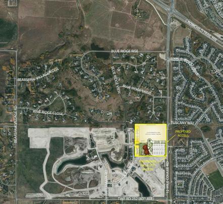
9 4.0 DEVELOPMENT PLAN CONTEXT 4.1 REGIONAL CONTEXT As shown on Figure 1: Regional Context, the Damkar Lands have a prominent location on the shared boundary between the City of Calgary and Rocky View County. Although located within the generally large-lot, country residential community of Bearspaw, the Damkar Lands form part of the transition between the high density city development in the city of Calgary and the relatively lower density development within Bearspaw. The subject lands are part of the Watermark Conceptual Scheme area, which sets density at a maximum of 1.95 units per gross acre for the overall area. This near urban density serves as a transition between the city of Calgary and the community of Bearspaw. The Damkar Lands are highly accessible due to 1 Mile Coulee Road which is used by Calgary and Rocky View residents to access commercial and retail services in the City. The lands are within the Rocky View/Calgary Intermunicipal Development Plan area as discussed in Section LEGAL DESCRIPTION As shown on Figure : Legal Description, the site includes approximately hectares (9 acres) within the SE of Section 18, Township Road 5, Range, West of the 5th Meridian. 4.3 LOCAL CONTEXT As shown on Figure 3: Local Development Context, existing and future subdivisions surrounding the Plan Area include a mix of larger-lot, lower density and smaller-lot, higher-density, single-family country residential developments, as well as villa-style development. The developments are generally characterized as follows: The subject lands are bounded to the north by the low-density residential area of Blueridge Mountain Estates. These lots include single-family homes serviced by groundwater wells and private septic treatment systems (PSTS). Spyglass Way in Watermark forms the boundary between the Watermark Community to the west and the Damkar Lands. To the west of Spy Glass Way is located single-family Watermark residential development. Villa-style multi-family development in Watermark forms the boundary to the south. 1 Mile Coulee Road forms the boundary to the east of the site. Development beyond 1 Mile Coulee Road is within the Tuscany community in the city of Calgary. 6
10 ACCESS R/W EASE UTILITY R/W UTILITY R/W GAS PIPE LINE R/W OVERLAND DRAINAGE R/W OVERLAND DRAINAGE R/W OVERLAND DRAINAGE R/W UTILITY R/W OVERLAND DRAINAGE R/W UTILITY R/W MR OVERLAND DRAINAGE R/W Figure : Legal Description UTILITY R/W 6 5 (4674 JK) UTILITY R/W 11 ( ) ROADWAY ( ) 9 Blue Ridge View R/W Pipeline R/W 4674 JK OVERLAND D 0616 ODR/W UR/W TUSCANY RESERVE 4674JK UR/W (MON) GR NW TUSCANY RESERVE RI NW TUSCANY RESERVE GA NW Tuscany Way NW ODR/W ODR/W UR/W OVERLAND DRAINAGE R/W UTILITY R/W UR/W NTS UTILITY R/W UR/W TUSCANY SPRINGS HL NW 4674JK UR/W UTILITY R/W 477LK AR/W ACCESS R/W WATERMARK ROAD ( ) 7 UTILITY R/W MAINTENANCE ACCESS R/W ( ) WATERS EDGE GARDENS ( ) MAINTENANCE ACCESS R/W 3PUL 5 31 WATERMARK ROAD SE ( ) PUL WATERSIDE COURT MAINTENANCE ACCESS R/W ( ) 1 Legend 11 1MR 10 9 MAINTENANCE ACCESS R/W ( ) SPYGLASS WAY 37 ( ) UTILITY R/W MR OVERLAND DRAINAGE R/W UTILITY R/W OVERLAND DRAINAGE R/W Subject Lands MAINTENANCE ACCESS R/W ( ) ( ) ( ) 4 Plan , Blk 1, Lot ha± (9.14 ac±) ( ) MAINTENANCE ACCESS R/W 6 MAINTENANCE ACCESS R/W 7 ( ) 8 9 ( ) 10MR MAINTENANCE ACCESS R/W ( ) MAINTENANCE ACCESS R/W SE Mile Coulee Road NW AR/W 79JK UR/W TRANSMISSION LINE R/W OVERLAND DRAINAGE R/W W ODR/W ODR/W OVERLAND DRAINAGE R/W UTILITY R/W UR/W TUSCANY RIDGE ME NW UR/W ODR/W ODR/W JK 7884JK UR/W ODR/W TUSCANY RIDGE HT NW ODR/W TUSCANY RIDGE HT NW UR/W TUSCANY RIDGE CR NW UR/W UTILITY R/W UR/W UTILITY R/W ODR/W ODR/W TUSCANY RIDGE BA NW UTILITY R/W UR/W OVERLAND DRAINAGE R/W OVERLAND DRAINAGE R/W ODR/W UR/W TUSCANY RIDGE HT NW UTILITY R/W TUSCANY RIDGE HT NW UTILITY R/W UR/W UR/W TUSCANY RIDGE HT NW ODR/W Watermark Conceptual Scheme Amendment Figure Legal Description May 013

11 Figure 3: Local development context 8
12 5.0 EXISTING CONDITIONS AND SITE ASSESSMENT 5.1 EXISTING LAND USE The current zoning for the Damkar parcel is Agricultural Holdings (AH) District in accordance with Rocky View County Bylaw C The purpose of the Agriculture Holdings District is to provide for a range of parcel sizes suitable for agricultural uses; the minimum parcel size is 8.10 hectares (0.01 acres). Development to the north of the Damkar Lands is currently zoned Residential One District (R-1) and development to the west and south is governed by Direct Control District 141 (Bylaw C ). Development to the east is located in the City of Calgary. Figure 4: Existing Land Use shows the current zoning regime in the local area. 5. EXISTING TOPOGRAPHY As shown on Figure 5: Existing Site Conditions, the subject lands consist of generally flat lands that slope towards the west with elevations ranging from approximately to metres. The plan area is currently being used for agricultural purposes and is under cultivation. There are no buildings located on the site. 5.3 GEOTECHNICAL & GROUNDWATER INVESTIGATION Test holes were drilled on the property as part of the Preliminary Geotechnical Assessment undertaken by Levelton in support of this development in 013. The soil profile at the test hole locations generally consisted of a thin layer of topsoil of 0.1 to 0.m in depth. This was followed by variable layers of silt and clay overlying clay till. Silt was 1.m in depth with a moisture content of 18.7% indicating relatively moist conditions. Clay was found between 3. and 6.4 metres below the ground surface level. A relatively shallow water table is present at the site, as revealed by groundwater monitoring, which showed a water level at 3.7 metres below the existing grade. Excavations deeper than. metres the existing ground surface may encounter groundwater seepage during the spring and summer months. These excavations may require temporary dewatering. The slopes on the subject property are considered stable under current conditions and the design of the church and proposed housing will continue to respond to all the requirements necessary to maintain this stability. 9


13 Figure 4: existing land use Subject Land 10

14 Figure 5: existing site conditions 11
15 5.4 EXISTING ACCESS As shown on Figure 6: Transportation, access for the site is currently via an all-turns intersection at Twelve Mile Coulee Road and a shared access with Sub Area 7 of the Watermark project. 1 Mile Coulee Road is a four-lane divided roadway between Highway 1A and Tusslewood Drive. South of Tusslewood Drive, it narrows to a two-lane undivided roadway. The road south of Highway 1A to Tuscany Way is classified as an Arterial. South of Tuscany Way, it is classified at a Primary Collector (7.0 metres). 5.5 BIOPHYSICAL OVERVIEW A Biophysical Overview was undertaken by Sweetgrass Consultants Ltd. in 013. A wetland was identified in the northwest portion of the site along with four stands of trees as well as some native and non-native grassland. These features are shown on Figure 7: Damkar Habitats. Preservation of the habitat areas is voluntary for the developer and consideration shall be given to incorporating the treed area in the west-central area at the subdivision stage. Compensation for the wetland may be required if removed and the developer will work with the Province regarding such requirements at the detailed design stage. 5.6 ARCHEOLOGICAL & HISTORICAL RESOURCES There are no archeological resources within the Plan Area. Historic Resource Act Clearance was granted by the Alberta Department of Culture and Community Spirit on September 4, 01 (HRM file # ). 5.7 ENVIRONMENTAL SITE ASSESSMENT A Phase 1 Environmental Site Assessment was completed by Almor Engineering Associates in 006. Based on the review of historical records, site recognizance and information available at the time of the Assessment, there are no known significant environmental impairments and no further assessment was recommended. 1
16 Figure 6: Transportation 13

17 Figure 7: Damkar habitats 14
18 6.0 DEVELOPMENT CONCEPT 6.1 LAND USE The Development Concept is shown in Figure 8: Development Concept. The concept includes a church site, a single-family residential site and a future residential development area. The single-family residential provides an appropriate transition and interface with the existing Watermark community. The Damkar Site has been divided into four (4) sub-areas in order to facilitate the future land use redesignations that will be required subsequent to the approval of this Appendix to the Watermark Conceptual scheme. These sub-areas are generally shown in Figure 8: Development Concept. Sub-area One (Church site) includes the church site. Sub-Area (Smaller Lot Residential) and Sub-Area 3 (Larger Lot Residential) include the planned single-family residential development on the west side of the concept. Sub-Area 4 (Future Development) will be left as in its current agricultural state pending a future application for residential development Sub-Area One (Church Site) Sub-Area One (Church Site) includes a church site and associated parking as well as open space features. The site is approximately ten (10) acres in size. The church is +/- 4,088 square metres (44,000 square feet) in size and will include a sanctuary, gymnasium, kitchen, cafeteria, meeting rooms, administrative offices and other related uses. A Public Utility Lot will also be required within Sub-Area One to service the entire plan area. POLICIES Sub-Area One (Church Site) Sub-Area One (Church Site) shall include a church site and associated uses, parking and open space amenity Sub-Area One (Church Site) shall include a connection to the regional pathway system Sub-Area One (Church Site) shall include a Public Utility Lot Sub-Area Two (Smaller-Lot Residential Development) Sub-Area Two (Smaller-Lot Residential Development) is designed to be in conformity with the Watermark Direct Control zoning (DC 141). The purpose of Sub-Area Two is to create a seamless transition between the Watermark Community to the west and the Damkar Lands. Sub-Area Two will be consistent with the Land Use Regulations in DC 141 for Site 6. 15
 Sub-Area Three (Larger Lot Residential) Sub-Area Four (Future Development Area)")
19 Figure 8: Development Concept Legend Sub-Area One (Church Site) NTS Sub-Area Two (Smaller Lot Residential) Sub-Area Three (Larger Lot Residential) Sub-Area Four (Future Development Area) 16
20 POLICIES Sub-Area Two (Smaller-Lot Residential Development) Sub-Area Two (Smaller-Lot Residential Development) shall be in conformity with the Land Use Regulations found in DC 141 for Site Residential development located within Sub-Area Two is expected to become part of the Watermark Homeowners Association Sub-Area Three (Larger-Lot Residential Development) Sub-Area Three (Larger-Lot Residential Development) is designed to be in conformity with the Watermark Direct Control zoning (DC 141). The purpose of Sub-Area Three is to create a seamless transition between the Blue Ridge Mountain Estates to the north, the Watermark Community to the west and the Damkar Lands. Sub-Area Three will be consistent with the Land Use Regulations in DC 141 for Site. POLICIES Sub-Area Three (Larger-Lot Residential Development) Sub-Area Three (Larger-Lot Residential Development) shall be in conformity with the Land Use Regulations found in DC 141 for Site Residential development located within Sub-Area Three is expected to become part of the Watermark Homeowners Association Sub-Area 4 (Future Development Area) Sub-Area 4 (Future Development Area) is designed to allow for the future development of the northwest area portion of the subject lands. Sub- Area 4 will require future submission of an additional Appendix to the Watermark Conceptual Scheme and the associated land use redesignation and subdivision processes. It is intended that Sub-Area 4 will be planned as future residential including seniors oriented living. Sub-Area 4 will be redesignated on an interim basis to Residential Three District (R-3) because of the reduction of parcel size caused by development on the remainder of the parcel. Agricultural Holdings District (AH) requires a minimum parcel size of 8.10 hectares (0.01 acres). POLICIES Sub-Area Four (Future Development Area) Intensification of development of Sub-Area Four (Future Development Area) will be subject to future Council approvals including an additional Appendix to the Watermark Conceptual Scheme and subsequent redesignation and subdivision. 17
21 6. TRANSPORTATION The Damkar Lands were included in the 008 Traffic Impact Assessment (TIA) and the 011 TIA for the Watermark Development; however, the nature of future development of the site was unknown at the time of those reports. As such, the original 008 study assumed that the Damkar Lands would consist of 60 single-family residential units and, similarly, the 011 update assumed a total of 57 single-family residential units on this parcel. Since the current proposed (church) site will generate fewer total trips than what was assumed in the previously completed studies, the development of the church is not expected to appreciably affect the adjacent road network. A separate TIA for the Damkar Lands was completed by Bunt & Associates in May 013. The 013 TIA found that for the opening day horizon, which includes the development of the church site (Sub-Area 1), the site access intersection with 1 Mile Coulee Road can be expected to operate within acceptable capacity parameters during the AM, PM and Sunday peak hours with only a stop sign for intersection control. No significant traffic impacts resulting from this overall development are anticipated at opening day. Study of the long-term development scenario shows that the eastbound (i.e. outbound) movement at the site access would be expected to operate at capacity during the Sunday peak hour with significant outbound queuing and delay. This queuing and delay would be located on-site only. However, signalization was not found to be warranted. It is noted that a church service functions as a weekly event occurring mainly on Sundays. Therefore, the impacts of the outbound capacity and delay issues are limited to church events and contained on-site. With the inclusion of the potential future seniors facility (Sub-Area 4) these conclusions are expected to remain the same, however it is suggested that the analysis be re-assessed in more detail once Sub-Area 4 is more active in terms of an application; signalization may be found to be necessary as a result of that level of development at the long-term horizon. Should there be found to be a need for improved intersection control, an Event Management Protocol could be developed for peak events. Alternatively, signalization or the implementation of a roundabout could be considered as part of the future development of the site. Therefore, this location should be monitored as part of the long-term horizon to ensure that the appropriate traffic control is put into place when necessary. An updated TIA will be required when future development of Sub- Area 4 is developed. Sub-Areas and 3 will be accessed via Spyglass Way and do not affect the onsite traffic related to the church development. Development of Sub-Areas and 3 were accounted for in the 011 TIA for the Watermark Community. Internal site access is shown in Figure 8: Development Concept. Internal access within the site will be paved and built to Rocky View County standards. 18
22 POLICIES Transportation 6..1 The developer shall construct the site access intersection with 1 Mile Coulee Road in accordance with the recommendations of the Traffic Impact Assessment (Bunt & Associates, May 013) to the satisfaction of Rocky View County and the City of Calgary. 6.. The Traffic Impact Assessment (Bunt & Associates, May 013) shall be circulated to the Rocky View County/City of Calgary Intermunicipal Cooperation Team Access within the Plan area shall be generally in accordance with Figure 8: Development Concept The internal subdivision road shall be constructed by the developer with a paved surface in accordance with all applicable Rocky View County engineering design standards The connection with 1 Mile Coulee Road shall be constructed by the developer to the satisfaction of the City of Calgary A Traffic Impact Assessment Update shall be required at the time of development of Sub-Area 4 (Future Development Area) and shall be circulated to the Intermunicipal Cooperation Team. 6.3 WATER AND WASTEWATER SERVICING Development of the Damkar Lands will include full-service water and sanitary servicing. Servicing will be provide from the Watermark Community as per Policy of the Watermark Conceptual Scheme which states that Communal wastewater treatment and water services will be provided to the Damkar Parcel under certain conditions, by the Watermark project (Page 30). A Utility Servicing Design Brief (May, 013) has been prepared by IBI Group in support of this Watermark Conceptual Scheme amendment. Water servicing will be provided via pipe from the Watermark Lands to the Damkar Lands. The Watermark parcel carries two licenses to obtain water from the Bow River with sufficient capacity to service the approved Watermark Community and the proposed development of the Damkar Lands. A water pumping station is located adjacent to the Bow River and a watermain has been built through an adjacent parcel located to the southwest of the Watermark Community. A water treatment plant is located in the southwest portion of the Watermark site. An experienced operator has been contracted to operate and maintain the water treatment system. The tie-in location for the water main for the Damkar Lands is on Spyglass Way within the Public Utility Lot (PUL). Two parallel water mains will be installed within the road right of way to maintain water pressure and supply as shown on Figure 9: Preliminary Utility Servicing. A water main feed will be provided along the east boundary to provide future servicing to lands to the north of the Damkar site. Water service connections for the single family residential lots will be from the water main in Spyglass Way. Wastewater servicing will be tied into Watermark s existing system via pipe and directed to the wastewater treatment plant located within Area 6 of the Watermark conceptual scheme at a central location within the community. The water will be treated to a high standard and discharged from the plant into an infiltration bed for eventual discharge into the bottom of Watermark s stormwater pond system. An experienced operator has been contracted to operate and maintain the wastewater treatment system. The sewer main for the Damkar Lands ties into the Watermark system on Spyglass Way within the PUL as shown on Figure 9: Preliminary Utility Servicing. The single family lots will be serviced individually to the existing sanitary sewers within Spyglass Way. The location of water and wastewater servicing is shown in Figure 9: Preliminary Utility Servicing. 19
23 Figure 9: Preliminary utility servicing Pipeline R/W 4674 JK 1:500 Spyglass Way NW Spyglass Way NW Pipeline R/W 4674 JK 1 Mile Coulee Road NW 1 Mile Coulee Road NW Legend Legend Subject Land Existing Water Main Existing Sanitary Sewer Main Existing Stormwater Main Proposed Water Main Proposed Sanitary Sewer Main Proposed Stormwater Main 1:500 Subject Land Existing Water Main Existing Sanitary Sewer Main Existing Stormwater Main Proposed Water Main Proposed Sanitary Sewer Main Proposed Stormwater Main Watermark Conceptual Scheme Amendment Figure 9 Preliminary Utilities Servicing May 013 0
24 POLICIES Water and Wastewater Piped potable water servicing shall be supplied from the Watermark Community to the Damkar Lands to the satisfaction of Rocky View County as per Figure 9: Preliminary Utility Servicing in accordance with the Alberta Water Act and any other Provincial requirements Piped wastewater servicing shall be supplied from the Watermark Community to the Damkar Lands to the satisfaction of Rocky View County as per Figure 9: Preliminary Utility Servicing in accordance with the Alberta Water Act and any other Provincial requirements The specific requirements of water and sanitary service connections for each for Sub-Area will be determined at the subdivision and/or development permit stage. 6.4 STORMWATER SERVICING Stormwater management will be integrated with that of the Watermark community and stormwater will be directed to Watermark s Wet Pond C. The runoff generated from from Sub-Areas 1, and 3 will exceed the allowable discharge rate for Wet Pond C. Therefore, on-site stormwater storage is required. This may include trap lows in the design of roads, landscape areas and parking lots. However, on-site storage will be determined through a stormwater report to be prepared at the detailed design stage (subdivision). Further study will be required to manage the stormwater runoff from Sub-Area 4 when future development is proposed. The single family lots will be serviced from the existing storm sewer in Spyglass Way. Flows from the Damkar Lands will be channelled into the Watermark System as per Figure 9: Preliminary Utility Servicing. The Watermark stormwater management system includes drainage by overland systems including roadside ditches along roads with curb and gutter with provision for swales. POLICIES Stormwater Servicing The developer shall construct a stormwater management system within the Plan area as generally illustrated by Figure 9: Preliminary Utility Servicing On-site stormwater storage will be determined through a stormwater report prepared at the subdivision stage The design of the BMP s shall be in accordance with all applicable Provincial regulatory requirements and Rocky View County engineering design standards The specific requirement of storm service connections for each Sub-Area will be determined at the subdivision and/or development permit stage. 1
25 6.5 SHALLOW UTILITIES Shallow utilities (i.e. electricity, telecommunication, natural gas, etc.) will be provided by the developer at the subdivision implementation stage in consultation with all applicable shallow utility providers. POLICIES Shallow Utilities Shallow utilities shall be installed and/or financed by the developer at the subdivision stage in consultation with all applicable utility providers The alignment of utility installations shall be determined at the subdivision stage in accordance with Rocky View County engineering design standards. 6.6 OPEN SPACE CONSIDERATIONS The open space system in the Development Concept has been designed to provide connectivity with the adjacent Watermark open space/pathway system and the regional open space system. The open space system is generally outlined in Figure 10: Open Space Considerations Private Open Space A landscaped transition area and pedestrian pathway system is provided along the west edge of the parcel to provide separation and transition between Sub-Area 1 (Church Site) and Sub-Area (Smaller-lot residential). A buffer is also provided along the southern edge of the property between the Villas to the south and the parking lot. Open space also separates the parking lot and the church itself. This landscaped transition is planned as a private open space area with public access and is 1.63 ha/4.04 ac in size. POLICIES Private Open Space Private Open Space shall be constructed by the developer as generally illustrated by Figure 10: Open Space Considerations The Private Open Space shall be maintained by the church owner and a public access easement will be registered against title to specify public access permission.
26 figure 10: open space considerations Pipeline R/W 4674 JK Legend NTS Spyglass Way NW Spyglass Way NW Pipeline R/W 4674 JK 1 Mile Coulee Road NW 1 Mile Coulee Road NW Legend Subject Lands Municipal Reserve 0. ha± (0.54 ac±) Potential Future Municipal Reserve 0.7 ha± (0.67 ac±) Private Open Space 1.63 ha± (4.04 ac±) Public Utility Lot 0.06 ha± (0.16 ac±) Trails Subject Lands Pathway Municipal to Reserve be Constructed by 0. Watermark ha± (0.54 ac±) Potential Future Municipal Reserve 0.7 ha± (0.67 ac±) Private Open Space 1.63 ha± (4.04 ac±) Public Utility Lot 0.06 ha± (0.16 ac±) Trails NTS Pathway to be Constructed by Watermark Watermark Conceptual Scheme Amendment Figure 10 Open Space Considerations May 013 3
27 6.6. Pedestrian Trail System A system of pedestrian trails will be provided within the open space area as generally illustrated on Figure 10: Open Space Considerations. The trails shall be constructed in accordance with applicable municipal engineering design standards. The trails will be maintained by the church owner. The developer shall construct the trail system in general accordance with the Figure 10: Open Space Considerations. The specific trail alignment, width and surface treatment will be determined in accordance with a Landscaping Plan to be prepared by a qualified professional at the subdivision stage. POLICIES Pedestrian Trail System A trail system shall be constructed by the developer within the Private Open Space area as generally illustrated by Figure 10: Open Space Considerations The trail system shall be owned and maintained by the church owners and shall be accessible to the public via a public access easement The specific alignment, width and surface treatment of trail system shall be determined by a Landscaping Plan to be prepared by a qualified professional at the subdivision stage to the satisfaction of Rocky View County Municipal Reserve (MR) The amount of land to be provided for municipal reserve will be equal to 10% of the Net Developable Area of the titled parcel(s) in accordance with Section 666 of the Municipal Government Act. MR can be a land dedication or can be paid as cash-in-lieu to Rocky View County. Within the Plan Area, MR will be dedicated along the west boundary of 1 Mile Coulee Road in order to facilitate a landscaped transitional area along 1 Mile Coulee Road. This MR Area is 0. ha/0.54 ac in size. A portion of the MR will be deferred to the development of Sub-Area 4 (Future Development Area). A portion of the MR will be paid as cash-in-lieu. 4
28 Municipal Reserve (MR) Calculation +/- ac +/- ha Gross Developable Area (GDA) Less Environmental Reserve (ER) 0 0 Net Developable Area (NDA) MR Outstanding (@ 10%) MR to be dedicated (within Church Site) MR to be deferred (within Sub-Area 4) (Future Development Area) Balance (to paid as cash-in-lieu) MR remaining (10%) 0 0 POLICIES Municipal Reserve Municipal Reserve (MR) parcels shall be dedicated in Sub-Area 1 as generally illustrated by Figure 10: Open Space Considerations Any outstanding Municipal Reserve (MR) shall be deferred to the development of Sub-Area 4 or paid to Rocky View County as cash-in-lieu as determined at the subdivision stage to the satisfaction of Rocky View County Municipal Reserve land and improvements within Sub-Area 1 (Church Site) shall be maintained by Rocky View County or by the church owners The details of Municipal Reserve (MR) design shall be determined by a Landscaping Plan to be prepared by a qualified professional at the subdivision stage to the satisfaction of Rocky View County. 5
29 6.7 COMMUNITY SUPPORT INFRASTRUCTURE Fire, Police & Emergency Services Fire services and emergency services will be provided by the City of Calgary through existing intermunicipal agreements. The Bearspaw Fire Station is currently under construction and will provide the support infrastructure for this area. Police services will be provided by the Royal Canadian Mounted Police and the Rocky View County Special Constables. POLICIES Fire, Police and Emergency Services Fire suppression shall be provided on - site for fire-fighting measures including the provision of sufficient fire hydrants as determined by Rocky View County and in conformity with the Provincial Building Code and other applicable standards and regulations Recreational Services The Watermark community is located within the Bearspaw Glendale Recreation District. The Bearspaw Glendale Lifestyle Centre provides a variety of recreational opportunities to residents within the area. However, the Centre is running at capacity and there is a need for further community space and recreational amenities in the area. The church located on the Damkar Lands could help to meet this need by providing a space that could be utilized by various community and recreational groups in the area. Moreover, overflow parking during off-peak hours could serve as a staging area for people to leave their cars while using the regional pathway and open space system in the area. POLICIES Recreation Services Recreational services within the Bearspaw Community may be supported with public use of the recreational amenities provided in Sub-Area 1 (Church site) on a fee for use basis, including the gymnasium and parking for pathway use. 6
30 7.0 IMPLEMENTATION Adoption of this Appendix to the Watermark Conceptual Scheme will establish the expectations guiding the implementation of development on the Damkar Lands. This Appendix provides a framework of land use policies that must be considered prior to subsequent consideration of land use amendment and/or subdivision tentative plan approval for development within the Plan Area. Consideration of this Appendix will occur following a statutory Public Hearing during which all matters will be considered and considerations from municipal staff, technical agency requirements and area landowner will be clarified. Rocky View County Council will consider adoption of this Appendix to the Watermark Conceptual Scheme pursuant to the requirements of the Municipal Government Act. Subsequently, consideration of land use amendment, subdivision and development permit applications will follow in accordance with the policies of this Appendix to the Watermark Conceptual Scheme and other Rocky View County development requirements. 7.1 DESIGN STANDARDS The built form of the development on the Damkar Lands will be consistent with the Watermark architectural and landscape design details as referenced in Section 6. of the Watermark Conceptual Scheme and the Rocky View County Commercial, Office and Industrial Design Guidelines. In a general sense, the Watermark trademark will be incorporated into open spaces and building forms. Design guidelines will be set out and implemented in a restrictive covenant registered against each residential lot on the Damkar Lands. The design standards for Sub-Area 1 and 4 will be administered by the developer. The design standards for Sub-Areas and 3 are expected to be administered by a Homeowner s Association. In general, these guidelines will consider: Site positioning and built form including minimizing building footprints and maintaining views; Community character and architectural guidelines including attention to natural features and architectural controls for each lot; Down-focused lighting designed to eliminate excessive lighting impacts on adjacent uses as per dark skies principles; and Landscaping and water conservation such as drought resistant plants, rain barrels and best management practices. 7
31 Figure 11: proposed land use and subdivision m 0.15m 41.90m Pipeline R/W 4674 JK 68.19m 43.87m Spyglass Way NW 15.18m 7.8m 7.8m 7.8m 6.30m 15.0m 30.0m 30.04m 30.04m 9.84m 48.55m 4.17m 4.6m 4.36m 4.45m 4.50m 4.50m 4.50m 4.50m 4.89m 4.96m 39.34m 7.8m 7.8m 7.8m 15.0m 11.m 15.0m 30.19m 30.04m 30.05m 9.95m m R4.0m 80.34m 176.5m m 15.0m m m 15.0m m 0.0m 1 Mile Coulee Road NW Legend Subject Land ha± (9.14 ac±) Agricultural Holding District to Public Service District (PS) 4.61 ha± (11.39 ac±) Agricultural Holding District to Residential Three District (R3) 5.86 ha± (14.47 ac±) Agricultural Holding District to Watermark Conceptual Scheme DC-141 Site Regulations 0.3 ha± (0.58 ac±) Agricultural Holding District to Watermark Conceptual Scheme DC-141 Site 6 Regulations 1.09 ha± (.70 ac±) 8
32 POLICIES Design Standards Watermark development standards and architectural guidelines shall be registered against the title of all residential properties and administered by the developer and/or a Homeowner s Association Development within the Damkar Lands shall adhere to a low-light policy ( dark skies principles) designed to be sensitive to the rural setting Water conservation and landscaping guidelines shall be registered against the title of all residential properties and administered by the developer and/or a Homeowner s Association. 7. PROPOSED LAND USE AMENDMENT Land use amendment (zoning) is expected to be applied by Council in accordance with the Rocky View County Land Use Bylaw as generally illustrated by Figure 11: Proposed Land Use and Subdivision Plan described as follows: Sub-Area 1 (Church Site) will be designated as Public Services (PS) District; Sub-Area (Smaller-lot residential) will be designated as part of an amendment to the Watermark Conceptual Scheme DC-141, Site 6 regulations; Sub-Area 3 (Larger-lot residential) will be designated as part of an amendment to the Watermark Conceptual Scheme DC-141, Site regulations; Sub-Area 4 (Future Development Area) will be designated as Residential Three District (R3); The area including the PUL will be designated as Public Services (PS) District; and The landscaped transitional area on the east side of the site including MR will be designated Public Services (PS) District. It is expected that Council will assign these land use amendments within the Plan area in accordance with one application to be considered concurrently with this Amendment to the Watermark Conceptual Scheme. POLICIES Land Use Amendment 7..1 Specific land uses are expected to be applied by a Council Zoning Amendment as generally illustrated by Figure 11: Proposed Land Use and Subdivision Plan. 9
33 figure 1: development phasing PHASE PHASE 3 PHASE PHASE 1 30
34 7.3 PROPOSED SUBDIVISION Implementation of subdivision within the Plan area is expected to occur as generally illustrated by Figure 11: Proposed Land use Subdivision Plan according to specific subdivision design criteria described as follows: A maximum of nine (9) residential parcels with individual lot sizing as per the DC-141 Site 6 regulations; A maximum of one (1) residential parcel with individual lot sizing as per the DC-141 Site regulations; A ± 0. ha/0.54ac Municipal Reserve dedication; A ±0.06 ha/0.16 ac Public Utility Lot; and Implementation of all supporting transportation & utility servicing infrastructure. POLICIES Policies Subdivision Implementation of subdivision is expected to proceed as generally illustrated by Figure 11: Proposed Land Use and Subdivision Plan. 7.4 DEVELOPMENT PHASING Development within the Plan Area is expected to proceed in three (3) phases as generally illustrated by Figure 1: Development Phasing. The developer will install transportation, utility servicing and recreational infrastructure as required by each development phase as required by the municipality in accordance with the terms of a Development Agreement. POLICIES Development Phasing Implementation of subdivision shall proceed in phases as generally illustrated by Figure 1: Development Phasing The phasing program may be adjusted subject to an approval from the Rocky View County Subdivision Approval Authority and the provision of required infrastructure Sub-Area Four (Future Development Area) will be subject to future Council approvals including an additional Appendix to the Watermark Conceptual Scheme and subsequent redesignation and subdivision in accordance with policy Sub-Area Four (Future Development Area. 31
35 7.5 WEED MANAGEMENT PLAN The developer shall prepare a Weed Management Plan in accordance with Rocky View County requirements to mitigate against invasive weeds during the construction and grading process. POLICIES Weed Management Plan A Weed Management Plan shall be provided by the developer at the subdivision stage to establish measures to mitigate against potential invasive weed issues during construction and grading. 7.6 CONSTRUCTION MANAGEMENT PLAN The developer shall prepare a Construction Management Plan at the subdivision stage to establish measures as may be required to mitigate ongoing construction issues. These issues may create negative impact for surrounding residents such as noise and construction access to the Plan area. POLICIES Construction Management Plan A Construction Management Plan shall be provided by the developer at the subdivision stage to establish potential mitigation requirements as may be necessary to limit negative impacts to surrounding residents during ongoing construction activities. SUPPORTING TECHNICAL STUDIES (UNDER SEPARATE COVER) 1. Phase One Environmental Site Assessment prepared for Pacific Continental by Almor Engineering Associates Ltd. dated May 18, 006;. Historical Resources Act - Signed Clearance Application ; 3. Preliminary Geotechnical Assessment prepared by Levelton Consultants Ltd. dated April 013; 4. Utility Servicing Design Brief prepared by IBI Group dated May 013; 5. Transportation Impact Assessment prepared by Bunt and Associates dated May 9, 013; and 6. Biophysical Overview prepared by Sweetgrass Consulting Ltd. dated June
City of Grande Prairie Development Services Department KENNEDY DEVELOPMENTS LTD. OUTLINE PLAN OP-09-01
 City of Grande Prairie Development Services Department KENNEDY DEVELOPMENTS LTD. OUTLINE PLAN OP-09-01 July 27, 2009 TABLE OF CONTENTS 1.0 Introduction... 1 1.1 Plan Area Location & Context... 1 1.2 Ownership
OP Council Resolution June 16, Planning and Development Services
 OP-08-01 Council Resolution June 16, 2008 Planning and Development Services Kingsgate Landing Outline Plan Table of Contents 1.0 Introduction 1 1.1 Purpose of Plan 1 1.2 Plan Area Location 1 1.3 Ownership
WEST HILL BUSINESS PARK AREA STRUCTURE PLAN
 MUNICIPAL DISTRICT OF PEACE NO. 135 WEST HILL BUSINESS PARK AREA STRUCTURE PLAN Prepared by: TABLE OF CONTENTS 1.0 Introduction... 1 1.1 Purpose of Plan........ 1 1.2 Plan Area..... 1 1.3 Existing Conditions...
City of Grande Prairie Development Services Department
 City of Grande Prairie Development Services Department ROYAL OAKS NORTH OUTLINE PLAN OP-07-03 NW 35-71-6 W6M May 7, 2007 Royal Oaks North Outline Plan TABLE OF CONTENTS 1.0 INTRODUCTION........ 3 1.1 Purpose
Bylaw C-1186 Adopted November 5, Planning and Development Services
 Bylaw C-1186 Adopted November 5, 2007 Planning and Development Services CITY OF GRANDE PRAIRIE OFFICE CONSOLIDATION BYLAW C-1186 A Bylaw to adopt the Westgate Area Structure Plan (As Amended by Bylaw C-1186-1,
ADMINISTRATION RECOMMENDATION(S) 2017 June 15. That Calgary Planning Commission recommends APPROVAL of the proposed Land Use Amendment.
 2017 June 15. That Calgary Planning Commission recommends APPROVAL of the proposed Land Use Amendment.") Page 1 of 7 EXECUTIVE SUMMARY The proposed land use amendment seeks to redesignate a Special Purpose Future Urban Development (S-FUD) District parcel in Residual Ward 3 Sub Area 3H to Industrial Outdoor
Page 1 of 7 EXECUTIVE SUMMARY The proposed land use amendment seeks to redesignate a Special Purpose Future Urban Development (S-FUD) District parcel in Residual Ward 3 Sub Area 3H to Industrial Outdoor
C ity of Grande Prairie Development Services Department
 C ity of Grande Prairie Development Services Department FAIRWAY DEVELOPMENT OUTLINE PLAN OP 08 09 Approved April 6, 2009 Prepared by: Focus Corporation Table of Contents 1.0. Introduction 2 3 1.1. Plan
LAND USE AMENDMENT CORNERSTONE (WARD 3) COUNTRY HILLS BOULEVARD AND STONEY TRAIL NE BYLAW 9D2017
 COUNTRY HILLS BOULEVARD AND STONEY TRAIL NE BYLAW 9D2017") Page 1 of 12 EXECUTIVE SUMMARY This Land Use Amendment application covers an area of 54.92 hectares ± (135.71 acres ±) located in northeast Calgary, bound by Country Hills Boulevard NE to the north and
Page 1 of 12 EXECUTIVE SUMMARY This Land Use Amendment application covers an area of 54.92 hectares ± (135.71 acres ±) located in northeast Calgary, bound by Country Hills Boulevard NE to the north and
Leduc Industrial Outline Plan SE W4
 Leduc Industrial Outline Plan SE 1-50-25-W4 Within the North Leduc Industrial ASP Prepared for: Leduc Energy Park Ltd. Prepared by: Stantec Consulting Ltd. File No. 1161 104655 V5 Table of Contents 1.0
ADMINISTRATION RECOMMENDATION 2016 November 03. That Calgary Planning Commission recommends APPROVAL of the proposed Land Use Amendment.
 Page 1 of 12 EXECUTIVE SUMMARY This Land Use Amendment application covers an area of 75.76 hectares ± (187.20 acres ±) located in northeast Calgary, bound by Stoney Trail NE to the north, 128 Avenue NE
Bylaw C-1262 Adopted February 6, Planning and Development Department
 Bylaw C-1262 Adopted February 6, 2012 Planning and Development Department CITY OF GRANDE PRAIRIE BYLAW C-1262 A Bylaw to adopt the Brookfield Neighbourhood Outline Plan THE MUNICIPAL COUNCIL OF THE CITY
LAND USE AMENDMENT CORNERSTONE (WARD 3) 60 STREET NE AND COUNTRY HILLS BOULEVARD NE MAP 26NE BYLAW 22D2017
 60 STREET NE AND COUNTRY HILLS BOULEVARD NE MAP 26NE BYLAW 22D2017") Page 1 of 14 EXECUTIVE SUMMARY This Land Use Amendment application covers an area of 43.76 hectares ± (108.14 acres ±) located in northeast Calgary, bound by Country Hills Boulevard NE to the south and
Page 1 of 14 EXECUTIVE SUMMARY This Land Use Amendment application covers an area of 43.76 hectares ± (108.14 acres ±) located in northeast Calgary, bound by Country Hills Boulevard NE to the south and
ROAD CLOSURE AND LAND USE AMENDMENT SILVER SPRINGS (WARD 1) NORTHEAST OF NOSEHILL DRIVE NW AND SILVER SPRINGS ROAD NW BYLAWS 2C2018 AND 29D2018
 NORTHEAST OF NOSEHILL DRIVE NW AND SILVER SPRINGS ROAD NW BYLAWS 2C2018 AND 29D2018") Page 1 of 19 EXECUTIVE SUMMARY This application proposes redesignating two parcels in the community of Silver Springs from Special Purpose Future Urban Development (S-FUD) District and undesignated road
Page 1 of 19 EXECUTIVE SUMMARY This application proposes redesignating two parcels in the community of Silver Springs from Special Purpose Future Urban Development (S-FUD) District and undesignated road
GRAYSTONE ESTATES CONCEPTUAL SCHEME
 GRAYSTONE ESTATES CONCEPTUAL SCHEME Bylaw C-5438-2001, Adopted November 6, 2001 MUNICIPAL DISTRICT OF ROCKY VIEW NO. 44 Department of Planning and Development TABLE OF CONTENTS 1.0 INTRODUCTION 5 1.1 Conceptual
BYLAW C A Bylaw of Rocky View County to amend Land Use Bylaw C
 BYLAW C-7720-2017 A Bylaw of Rocky View County to amend Land Use Bylaw C-4841-97. The Council of Rocky View County enacts as follows: PART 1 TITLE This Bylaw shall be known as Bylaw C-7720-2017. PART 2
Land Use Amendment in Southwood (Ward 11) at and Elbow Drive SW, LOC
 at and Elbow Drive SW, LOC") 2018 November 15 Page 1 of 10 EXECUTIVE SUMMARY This land use amendment application was submitted by Rick Balbi Architect on 2017 August 31 on behalf of Sable Developments Ltd, and with authorization from
2018 November 15 Page 1 of 10 EXECUTIVE SUMMARY This land use amendment application was submitted by Rick Balbi Architect on 2017 August 31 on behalf of Sable Developments Ltd, and with authorization from
Palisades Outline Plan
 NE ¼ 25 36 28 W4 Town of Penhold Approved August 13, 2012 Contents Figures & Tables... 2 Introduction... 1 Overview... 1 Purpose... 1 Development Area... 3 Ownership... 3 Topography... 3 Existing & Surrounding
SANDSTONE SPRINGS AREA STRUCTURE PLAN
 Sandstone Springs Development Corp. AREA STRUCTURE PLAN This report is prepared for the sole use of Sandstone Springs Development Corp. No representations of any kind are made by Urban Systems Ltd. or
Outline Plan in Belvedere (Ward 9) at Street SE, LOC (OP)
 at Street SE, LOC (OP)") 2018 October 04 Page 1 of 12 EXECUTIVE SUMMARY This outline plan application was submitted by B&A Planning Group on 2016 July 15, on behalf of Tristar Communities Inc. for 50.14 hectares (123.89 acres)
2018 October 04 Page 1 of 12 EXECUTIVE SUMMARY This outline plan application was submitted by B&A Planning Group on 2016 July 15, on behalf of Tristar Communities Inc. for 50.14 hectares (123.89 acres)
CONCEPTUAL SCHEME FULTON INDUSTRIAL
 CONCEPTUAL SCHEME FULTON INDUSTRIAL Bylaw C-6919-2010 Adopted June 22, 2010 ROCKY VIEW COUNTY BYLAW C-6919-2010 A Bylaw of Rocky View County to adopt a Conceptual Scheme known as the Fulton Industrial
ADMINISTRATION RECOMMENDATION(S) 2017 February 09. That Calgary Planning Commission recommends APPROVAL of the proposed Land Use Amendment.
 2017 February 09. That Calgary Planning Commission recommends APPROVAL of the proposed Land Use Amendment.") Page 1 of 10 EXECUTIVE SUMMARY This land use amendment application is to accommodate changes to the location of a stormwater retention pond and land use boundaries adjacent to Environmental Reserve in
Page 1 of 10 EXECUTIVE SUMMARY This land use amendment application is to accommodate changes to the location of a stormwater retention pond and land use boundaries adjacent to Environmental Reserve in
CENTRAL PARK MAJOR AREA STRUCTURE PLAN. Bylaw No. 2017/30, Adopted February 20, P a g e
 CENTRAL PARK MAJOR AREA STRUCTURE PLAN Bylaw No. 2017/30, Adopted February 20, 2018 1 P a g e Table of Contents 1.0 Introduction 4 1.1 Background 4 1.2 Purpose 4 1.3 Location 4 1.4 Planning Process 4
ADMINISTRATION RECOMMENDATION(S) 2016 November 03. That Calgary Planning Commission recommends APPROVAL of the proposed Land Use Amendment.
 2016 November 03. That Calgary Planning Commission recommends APPROVAL of the proposed Land Use Amendment.") Page 1 of 7 EXECUTIVE SUMMARY This Land Use Amendment application seeks to redesignate a portion of the parcel from Industrial General (I-G) District to Special Purpose City and Regional Infrastructure
Page 1 of 7 EXECUTIVE SUMMARY This Land Use Amendment application seeks to redesignate a portion of the parcel from Industrial General (I-G) District to Special Purpose City and Regional Infrastructure
WESTMINSTER GLEN CONCEPTUAL SCHEME
 WESTMINSTER GLEN CONCEPTUAL SCHEME Bylaw C-5379-2001, Adopted July 31, 2001 MUNICIPAL DISTRICT OF ROCKY VIEW NO. 44 Department of Planning and Development MUNICIPAL DISTRICT OF ROCKY VIEW NO. 44 BYLAW
Red Fox Commercial Outline Plan
 Red Fox Commercial Outline Plan City of Cold Lake, Alberta Prepared by Durrance Projects Ltd and Ross W. Sharp & Associates Ltd October 2014 Rupert 1 Table of Contents 1. PURPOSE...3 1.1. Location...4
This application has been applied for with support of an Outline Plan to provide the technical details for the site s development.
 Page 1 of 13 EXECUTIVE SUMMARY This application consists of a Land Use Amendment application proposing redesignation from Special Purpose Future Urban Development (S-FUD) District to an assortment of multiresidential,
S o u t h C e n t r a l O u t l i n e P l a n. Leduc Business Park. North Leduc Industrial Area Structure Plan C it y of Led u c.
 Leduc Business Park North Leduc Industrial Area Structure Plan C it y of Led u c Prepared for Farm Air Properties Inc. January, 2007 Table of Contents Page Number 1.0 Purpose of Plan and Definition of
The Uplands Area Structure Plan. City of Cold Lake, NE & SE W4
 City of Cold Lake, NE & SE 13-63-2-W4 July 2009 1 Contents 1 Background information... 1 1.1 Foreword... 1 1.2 Purpose... 1 1.3 Plan Area and Location... 1 1.4 Ownership... 2 2 Factors Influencing Development...
Bylaw No Page 1
 Bylaw No. 876-2014 Page 1 A BYLAW OF THE CITY OF LEDUC IN THE PROVINCE OF ALBERTA, TO ADOPT THE AREA STRUCTURE PLAN FOR THE: SOUTH WEST QUARTER OF 31-49-25-W4M The Municipal Government Act, R.S.A. 2000,
March 21, 2018 ALCA Meeting. March 21, 2018
 March 21, 2018 ALCA Meeting March 21, 2018 Agenda 1. Process and Timeline 2. Original Submission 3. Revised Submission 4. Next Steps The City of Calgary Role: The City is responsible for capturing and
BRIDGES OF LANGDON CONCEPTUAL SCHEME
 BRIDGES OF LANGDON CONCEPTUAL SCHEME Office Consolidation This page contains the history of relevant bylaws affecting this office consolidation. A copy of the original Bylaw and all amending Bylaws can
LAND USE AMENDMENT DOWNTOWN COMMERCIAL CORE (WARD 7) MACLEOD TRAIL SE AND 5 AVENUE SE BYLAW 254D2017
 MACLEOD TRAIL SE AND 5 AVENUE SE BYLAW 254D2017") Page 1 of 10 EXECUTIVE SUMMARY This Land Use Amendment application seeks to redesignate a full downtown block (currently the YWCA site) from a Direct Control based on the CM-2 District (Land Use Bylaw
Page 1 of 10 EXECUTIVE SUMMARY This Land Use Amendment application seeks to redesignate a full downtown block (currently the YWCA site) from a Direct Control based on the CM-2 District (Land Use Bylaw
OUTLINE PLAN FOR A CLUSTER RESIDENTIAL DEVELOPMENT
 OUTLINE PLAN FOR A CLUSTER RESIDENTIAL DEVELOPMENT M.D. FOOTHILLS NO. 31 AS ADOPTED DECEMBER 3 rd, 2014 ACKNOWLEDGEMENT PAGE PREPARED FOR: PROJECT CONSULTANT TEAM: B&A Planning Group Eagle Engineering
AREASTRUCTURE PLAN AMENDMENT COCHRANE NORTH
 AREASTRUCTURE PLAN AMENDMENT COCHRANE NORTH In order to implement the vision outlined in the Conceptual Scheme, the following three amendments to the Cochrane North ASP are proposed: 1. Allow commercial
Proposed Kenmount Hill CDS Amendment. Public Hearing October 25 th, 2018
 Proposed Kenmount Hill CDS Amendment Public Hearing October 25 th, 2018 History of Kenmount Hill Why Kenmount Hill? Why Now? We are a city with a vision for growth and the development of Kenmount Hill
Arbour Lake Development Application
 Arbour Lake Development Application This public engagement session is intended to share information about the proposal to develop the Hawkwood Farm, answer questions and collect feedback on various parts
TABLE OF CONTENTS. Sierra Springs Outline Plan
 Sierra Springs Outline Plan TABLE OF CONTENTS 1. Introduction...3 1.1. Purpose of the Plan... 3 1.2. The Approval Process... 3 1.3. Policy and Legislative Framework... 3 2. Development Area...6 2.1. Location
MUNICIPAL DISTRICT OF ROCKY VIEW NO.
 BEARSPAW AREA STRUCTURE PLAN Bylaw C-4129-93, Adopted January 18, 1994 MUNICIPAL DISTRICT OF ROCKY VIEW NO. 44 Department of Planning and Development BEARSPAW AREA STRUCTURE PLAN BY-LAW C-4129-93 January,
GATEWAY AREA STRUCTURE PLAN
 CHESTERMERE GATEWAY AREA STRUCTURE PLAN COMMUNITY OPEN HOUSE SEPTEMBER 22 nd, 2015 PLAN AREA ± 512 hectares (± 1,265 acres) GATEWAY LOCATION UNDEVELOPED LANDS PRESENT AGRICULTURAL USE REGIONAL LAND USE
SECTION E. Realizing the Plan
 SECTION E Realizing the Plan 60 DESIGN REGINA - OFFICIAL COMMUNITY PLAN SECTION E Realizing the Plan Design Regina has been an ambitious plan-making exercise, with a high level of community, stakeholder,
CottageClub Ghost Lake Conceptual Scheme
 CottageClub Ghost Lake Conceptual Scheme Bylaw C-6585-2007, Adopted January 15, 2008 MUNICIPAL DISTRICT OF ROCKY VIEW NO. 44 Department of Planning and Community Services MUNICIPAL DISTRICT OF ROCKY VIEW
Slope Stability Management Framework
 Slope Stability Management Framework For the assessment, evaluation, prioritization and mitigation of slope stability concerns. 2013/06/19 The Slope Stability Management Framework provides guidance to
Prepared for: Prepared by: Revised November 2013 by Stantec Consulting Ltd. 200, th Street Se Calgary, AB, T2A 7H8
 Prepared for: Prepared by: PLANNING PROTOCOL INC. 3916 1 ST STREET N.E. CALGARY, AB. T2E 3E3 Revised November 2013 by Stantec Consulting Ltd. 200, 325 25 th Street Se Calgary, AB, T2A 7H8 Table of Contents
AREA STRUCTURE PLAN NE W5M. Adopted by Council September 27, 2010 Bylaw
 AREA STRUCTURE PLAN NE 5-33-1 W5M Adopted by Council September 27, 2010 Bylaw 2010-14 CONTENTS 1.0 Introduction... 3 1.1 Purpose... 3 1.2 Objectives... 3 1.3 Discovery Plains Community Vision... 3 1.3.1
Drexel, Barrell & Co.
 Drexel, Barrell & Co. June 18, 2018 Engineers/Surveyors Boulder Colorado Springs Greeley 3 South 7 th Street Colorado Springs, Colorado 80905-1501 719 260-0887 719 260-8352 Fax El Paso County Planning
ADMINISTRATION RECOMMENDATION(S) 2018 January 25. That Calgary Planning Commission recommend APPROVAL of the proposed Land Use Amendment.
 2018 January 25. That Calgary Planning Commission recommend APPROVAL of the proposed Land Use Amendment.") Page 1 of 9 EXECUTIVE SUMMARY This land use amendment proposes to redesignate a parcel from DC Direct Control District to Multi-Residential Contextual Grade-Oriented (M-CG) District to allow for multi-residential
Page 1 of 9 EXECUTIVE SUMMARY This land use amendment proposes to redesignate a parcel from DC Direct Control District to Multi-Residential Contextual Grade-Oriented (M-CG) District to allow for multi-residential
Mayliewan Neighbourhood Structure Plan Neighbourhood 7 of the Edmonton North Area Structure Plan
 Mayliewan Neighbourhood Structure Plan Neighbourhood 7 of the Edmonton North Area Structure Plan Office Consolidation November 2008 Prepared by: Planning and Policy Services Branch Planning and Development
TABLE OF CONTENTS 1.0 INTRODUCTION GENERAL OBJECTIVES LAND USE DESIGNATIONS, OBJECTIVES AND POLICIES 4
 Schedule I- Redstone Golf Course Resort Area Sector Plan 1 TABLE OF CONTENTS 1.0 INTRODUCTION 3 2.0 GENERAL OBJECTIVES 3 3.0 LAND USE DESIGNATIONS, OBJECTIVES AND POLICIES 4 4.0 TRANSPORTATION AND ROAD
Area Structure Plan. A Community for All Seasons. Prepared for the Town of Strathmore. Consolidated September 28, 2015
 Area Structure Plan Prepared for the Town of Strathmore A Community for All Seasons Lakewood Meadows Area Structure Plan Prepared for the Town of Strathmore And Lakewood Meadows Inc. i Table of Contents
THAT the attached Terms of Reference for the Thornhill Centre Street Study be approved.
 COMMITTEE OF THE WHOLE AUGUST 18, 2003 THORNHILL CENTRE STREET STUDY PLANNING FILE: 15.92 Recommendation The Commissioner of Planning recommends: THAT the attached Terms of Reference for the Thornhill
Waverley West B Secondary Planning Process. Open House South Pointe School April 25, 2018
 averley est B Secondary Planning Process South Pointe School April 25, 2018 averley est B Secondary planning process open house Please review the boards and provide your feedback. 1 The Role of a Secondary
6 Growth Management Challenges and Opportunities
 6 Growth Management Challenges and Opportunities The Town has established a goal of attaining a 50% participation rate with respect to employment opportunities versus residential population. The Town s
THE CITY OF WINNIPEG BY-LAW NO. 4/2013. A By-law of THE CITY OF WINNIPEG to adopt a Secondary Plan for the Waverley West Southwest Neighbourhood.
 THE CITY OF WINNIPEG BY-LAW NO. 4/2013 A By-law of THE CITY OF WINNIPEG to adopt a Secondary Plan for the Waverley West Southwest Neighbourhood. THE CITY OF WINNIPEG, in Council assembled, enacts as follows:
Municipal Development Plan Update Urban Service Area and Hamlets
 ENCLOSURE 1 Municipal Development Plan Update Urban Service Area and Hamlets Priorities Committee January 24, 2017 MUNICIPAL DEVELOPMENT PLAN UPDATE SHAPING OUR FUTURE MDP Update - Agenda MDP Update Public
EXHIBIT B PROJECT NARRATIVE POULSBO MEADOWS
 EXHIBIT B PROJECT NARRATIVE POULSBO MEADOWS Name of Project: Poulsbo Meadows; A Planned Residential Development (PRD)/Plat Applicants Name: PBH Group LLC/Byron Harris PO Box 1010 Silverdale, WA 98038 Description
Applicant Name Phone / Fax / Address City State Zip Code . Property Owner Phone / Fax / Address City State Zip Code
 Master Development Plan Application Community Development Department City of Redmond 411 SW 9 th Street Redmond, Oregon 97756 541-923-7721 541-548-0706 FAX Master Development Plan Fee $38,862.52 File Number
Gold Line Bus Rapid Transit Transit Oriented Development (BRTOD) Helmo Station Area Plan
 Helmo Station Area Plan") Appendix F Gold Line Bus Rapid Transit Transit Oriented Development (BRTOD) Helmo Station Area Plan Introduction and Purpose of the Plan The Gold Line Bus Rapid Transit facility is an eleven-mile dedicated
Appendix F Gold Line Bus Rapid Transit Transit Oriented Development (BRTOD) Helmo Station Area Plan Introduction and Purpose of the Plan The Gold Line Bus Rapid Transit facility is an eleven-mile dedicated
Drexel, Barrell & Co.
 Drexel, Barrell & Co. December 21, 2018 Engineers/Surveyors Boulder Colorado Springs Greeley 3 South 7 th Street Colorado Springs, Colorado 80905-1501 719 260-0887 719 260-8352 Fax El Paso County Planning
Ten Mile Creek Planning Area
 PLANNING AREA POLICIES TEN MILE CREEK Ten Mile Creek Planning Area Location and Context The Ten Mile Creek Planning Area ( Ten Mile Creek area ) is located south of the current Boise AOCI, generally south
Poplar Ridge Area Structure Plan. Poplar Ridge. Area Structure Plan
 Poplar Ridge Area Structure Plan Bylaw 899 16 Adopted August 15, 2017 1 Contents 1 Introduction... 3 2 Background... 3 2.1 Purpose of the Plan... 3 2.2 Vision... 4 3 Description of the Plan Area... 5 3.1
Bylaw No. B-03/2011 Adopted by Airdrie City Council February 21, 2012
 COOPER S CROSSING STAGE 4 Neighbourhood Structure Plan City of Airdrie WESTMARK HOLDINGS LTD. Bylaw No. B-03/2011 Adopted by Airdrie City Council February 21, 2012 CONSULTANTS: LAND USE PLANNING: Southwell
HAMPTONS Area Structure Plan Medicine Hat, Alberta
 HAMPTONS Medicine Hat, Alberta Prepared for: Lansdowne Equity Ventures Ltd. Prepared by: UMA Engineering Ltd. May 2005 Table of Contents Page No. 1. INTRODUCTION...1 1.1 Purpose...1 1.2 Location & Existing
Request for Decision. Recommendation. Presented: Monday, Jul 07, Report Date Friday, Jun 20, Type: Public Hearings
 Presented To: Planning Committee Request for Decision Application for rezoning in order to permit a place of worship on a vacant lot zoned for C1, Local Commercial uses, Cam Street, Sudbury Sitiri Investments
DAVENPORT VILLAGE SECONDARY PLAN
 27 DAVENPORT VILLAGE SECONDARY PLAN 27. DAVENPORT VILLAGE SECONDARY PLAN 1. VISION FOR THE DAVENPORT VILLAGE SECONDARY PLAN Davenport Village, municipally known as 830, 940, 980 and 1100 Lansdowne Avenue,
Master Site Development Plan (MSDP) Rocky View County Campus at Balzac East
 Rocky View County Campus at Balzac East") Master Site Development Plan (MSDP) Rocky View County Campus at Balzac East Balzac East, Alberta July 2009 CONTENTS 1.0 purpose 1 2.0 guiding principles 2 3.0 site description 3 4.0 site analysis and county
Master Site Development Plan (MSDP) Rocky View County Campus at Balzac East Balzac East, Alberta July 2009 CONTENTS 1.0 purpose 1 2.0 guiding principles 2 3.0 site description 3 4.0 site analysis and county
HAMLET OF KINGMAN AREA STRUCTURE PLAN
 HAMLET OF KINGMAN AREA STRUCTURE PLAN Prepared by: Austrom Consulting Ltd. Page 1 of 19 Table of Contents TABLE OF CONTENTS... 2 1. BACKGROUND... 3 1.1 PLAN AREA... 3 1.2 PLAN PURPOSE... 3 1.3 LEGISLATIVE
SPECIFIC PLAN Requirements
 CITY OF LANCASTER PLANNING DEPARTMENT 44933 Fern Avenue, Lancaster, California 93534 (661) 723-6100 SPECIFIC PLAN Requirements Purpose The purpose of a specific plan is to provide for the logical development
MUNICIPAL DEVELOPMENT PLAN
 MUNICIPAL DEVELOPMENT PLAN Bylaw C-4840-97 Adopted on July 6, 1998 MUNICIPAL DISTRICT OF ROCKY VIEW NO. 44 Department of Planning and Development & Building Services MUNICIPAL DISTRICT OF ROCKY VIEW NO.
City of Calgary and MD of Foothills Intermunicipal Development Plan
 City of Calgary and MD of Foothills Intermunicipal Development Plan Information Package for Public Open House #3 March 2, 2016 at the DeWinton Community Hall 3-8pm This information package is being provided
9 CITY OF VAUGHAN OFFICIAL PLAN AMENDMENT NO BOCA EAST INVESTMENTS LIMITED
 9 CITY OF VAUGHAN OFFICIAL PLAN AMENDMENT NO. 631 - BOCA EAST INVESTMENTS LIMITED The Planning and Economic Development Committee recommends the adoption of the recommendations contained in the following
Municipal Development Plan. Summer Village of ROCHON SANDS. Bylaw #241-18
 Municipal Development Plan Summer Village of ROCHON SANDS Bylaw #241-18 TABLE OF CONTENTS PART ONE: BACKGROUND AND PURPOSE 3 SECTION 1: BACKGROUND 3 SECTION 2: GOALS AND POLICIES 3 PART TWO: PHYSICAL ENVIRONMENT
Rocky View County Plans
 COUNTY PLAN Guides overall growth and development for the county. INTER-MUNICIPAL DEVELOPMENT PLAN Guides growth and development in an area where the County shares a border with another municipality. -
POLICY AMENDMENT AND LAND USE AMENDMENT TUXEDO PARK (WARD 9) CENTRE STREET N AND 26 AVENUE NE BYLAWS 36P2017 AND 234D2017
 CENTRE STREET N AND 26 AVENUE NE BYLAWS 36P2017 AND 234D2017") Page 1 of 11 EXECUTIVE SUMMARY This application proposes to redesignate a single parcel of land in the Community of Tuxedo Park from Commercial Corridor 2 (C-COR2 f1h10) District to Mixed Use Active Frontage
Page 1 of 11 EXECUTIVE SUMMARY This application proposes to redesignate a single parcel of land in the Community of Tuxedo Park from Commercial Corridor 2 (C-COR2 f1h10) District to Mixed Use Active Frontage
PRELIMINARY CONDITIONAL USE SUBMITTAL CHECKLIST REQUIREMENTS
 This checklist must accompany your submittal as the cover page. CONDITIONAL USE Application Submittal Checklist for PRELIMINARY AND FINAL APPROVAL Per Winter Park Land Development Code Sec. 58-90 PRELIMINARY
Central and East Neighbourhoods - Hermitage Outline Plan
 Central and East Neighbourhoods - Hermitage Outline Plan Office Consolidation September 2013 Prepared by: Planning and Policy Services Branch Planning and Development Department City of Edmonton The Central
Asbury Chapel Subdivision Sketch Plan
 Asbury Chapel Subdivision Sketch Plan PART 1: PROJECT SUMMARY Applicant: NVR Inc. Project Size: +/- 76.13 acres Parcel Numbers: 02101112,02116101,02116112, 02116113 Current Zoning: Transitional Residential
Description of Preferred Alternative
 Chapter 2 Description of Preferred Alternative 2.1 Introduction This chapter of the programmatic Sammamish Town Center Sub-area Plan Final EIS provides a more detailed description of the Preferred Alternative
NEIGHBOURHOOD STRUCTURE PLAN
 NEIGHBOURHOOD STRUCTURE PLAN December 2012 2437.0023.06 This report is prepared for the sole use of Vesta Properties Ltd. No representations of any kind are made by Urban Systems Ltd. or its employees
MICHENER HILL EAST. Neighbourhood Area Structure Plan. - Red Deer - InterPLAN strategies inc.
 MICHENER HILL EAST Neighbourhood Area Structure Plan - Red Deer - InterPLAN strategies inc. Adopted by City Council, Bylaw 3217/E-2007, June 18, 2007 Michener Hill East Neighbourhood Area Structure Plan
The West Vaughan Employment Area Secondary Plan Policies
 Part 2: The West Vaughan Employment Area Secondary Plan Policies 2.1 General Policies It is the policy of Council: 2.1.1. That the West Vaughan Employment Area (the WVEA), identified on Schedule 1, will
WINTERBURN INDUSTRIAL AREA STRUCTURE PLAN
 OCTOBER 2009 Winterburn Industrial Area Structure Plan Office Consolidation November 2012 Prepared by: Current Planning Branch Sustainable Development City of Edmonton Bylaw 15356, was adopted by Council
Staff Report and Recommendation
 Community Planning and Development Planning Services 201 W. Colfax Ave., Dept. 205 Denver, CO 80202 p: 720.865.2915 f: 720.865.3052 www.denvergov.org/cpd TO: City Council Neighborhoods and Planning Committee
Wintergreen Redevelopment Conceptual Scheme
 Wintergreen Redevelopment Conceptual Scheme Wintergreen Redevelopment Conceptual Scheme Resorts of the Canadian Rockies 1505-17 Avenue SW Calgary, AB T2T 0E2 Attention: Patrick Majer Development and Utility
ARTICLE 6: Special and Planned Development Districts
 ARTICLE 6: Special and Planned Development Districts 6-10 Traditional Neighborhood Development (TND) District 6-10.10 Purpose and Intent The Traditional Neighborhood Development (TND) District provides
INDUS AREA STRUCTURE PLAN
 INDUS AREA STRUCTURE PLAN Bylaw C-5982-2004, Adopted November 9, 2004 MUNICIPAL DISTRICT OF ROCKY VIEW NO. 44 Department of Planning and Development MUNICIPAL DISTRICT OF ROCKY VIEW NO. 44 BYLAW C-5982-2004
URBAN DESIGN BRIEF 305, 309, & 315 SOUTHDALE ROAD WEST LONDON ONTARIO
 URBAN DESIGN BRIEF 305, 309, & 315 SOUTHDALE ROAD WEST LONDON ONTARIO CARVEST PROPERTIES LTD. December 2013 Section 1 - Land Use Planning Context 1.1 Subject Lands The subject lands are located immediately
BYLAW NO. 3549/2015. Being a Bylaw of The City of Red Deer to provide a uniform levy of off-site costs in respect of previously undeveloped land.
 BYLAW NO. 3549/2015 Being a Bylaw of The City of Red Deer to provide a uniform levy of off-site costs in respect of previously undeveloped land. 1 WHEREAS pursuant to provisions of Section 648 of the Municipal
SUMMER VILLAGE OF SUNRISE BEACH
 SUMMER VILLAGE OF SUNRISE BEACH Municipal Development Plan Bylaw No. 132-13 ~ 2 ~ Summer Village of Sunrise Beach Municipal Development Plan 1 INTRODUCTION 1.1 SETTING The Summer Village of Sunrise Beach
9 th Street Sub Area Plan
 9 th Street Sub Area Plan In the 1990 s, when the Township prepared the last Master Plan, the 9 th Street corridor was studied as part of a larger 9 th Street Focus Area that included the West Main Street
When planning stormwater management facilities, the following principles shall be applied where possible.
 2.0 Principles When planning stormwater management facilities, the following principles shall be applied where possible. 2.0.1 Drainage is a regional phenomenon that does not respect the boundaries between
NEIGHBORHOOD STRUCTURE PLAN
 June 19, 2006 BYLAW 05/2006 NEIGHBORHOOD STRUCTURE PLAN ADOPTED BY CITY COUNCIL June 19, 2006 BYLAW 05/2006 Prepared for: Hopewell Residential Communities Prepared by: Brown & Associates Planning Group
Rezoning. Rezone from A-1 to RH to create 9 suburban single family residential lots. Approval to Proceed
 City of Surrey PLANNING & DEVELOPMENT REPORT Rezoning Proposal: Rezone from A-1 to RH to create 9 suburban single family residential lots. Recommendation: Approval to Proceed Location: 18712 and Portion
URBAN DESIGN BRIEF. 2136&2148 Trafalgar Road. Town of Oakville
 URBAN DESIGN BRIEF 2136&2148 Trafalgar Road Town of Oakville Prepared By: METROPOLITAN CONSULTING INC For 2500674 Ontario Inc November 2016 TABLE OF CONTENTS Page No. 1.0 Introduction/Description of Subject
THE CITY OF WINNIPEG BY-LAW NO. 97/2014
 THE CITY OF WINNIPEG BY-LAW NO. 97/2014 A By-law of THE CITY OF WINNIPEG to adopt a secondary plan for Precinct E of the Complete Communities Direction Strategy By-law No. 68/2010. THE CITY OF WINNIPEG,
A Guide to Open Space Design Development in Halifax Regional Municipality
 A uide to Open Space Design Development in Halifax Regional Municipality May 2007 1 Introduction Pursuant to Section 3.5 of the Regional Municipal Planning Strategy (RMPS), subdivision of land may proceed
Westwind Developments Ltd. PIONEER LANDS AREA STRUCTURE PLAN - PROPOSED AMENDMENT
 FEBRUARY 2013 TABLE OF CONTENTS 1.0 BACKGROUND... 1 1.1 Amendment... 1 2.0 LOCATION & CONTEXT... 2 2.1 Land Ownership... 2 3.0 POLICY CONTEXT... 3 3.1 Municipal Development Plan... 3 3.2 Capital Region
A Growing Community Rural Settlement Areas
 Town of Huntsville Official Plan Review - POLICY BACKGROUND PAPER A Growing Community Rural Settlement Areas BACKGROUND: In addition to the fully municipally-serviced Urban Settlement Area and the Hidden
The Illinois Department of Transportation and Lake County Division of Transportation. Route 173, including the Millburn Bypass
 The Illinois Department of Transportation and Lake County Division of Transportation welcome you to this Public Hearing for U.S. Route 45 from Illinois Route 132 to Illinois Route 173, including the Millburn
Local Growth Planning in North Central Green Line Communities
 2018 April 30 Page 1 of 6 EXECUTIVE SUMMARY This report outlines a high-level scope for local growth planning for north central Green Line communities. The catalyst for this review is the significant investments
POLICY AMENDMENT AND LAND USE AMENDMENT KILLARNEY/GLENGARRY (WARD 8) NW CORNER OF RICHMOND ROAD AND 33 STREET SW BYLAWS 1P2015 AND 7D2015
 NW CORNER OF RICHMOND ROAD AND 33 STREET SW BYLAWS 1P2015 AND 7D2015") Page 1 of 13 EXECUTIVE SUMMARY This application seeks to redesignate an RC-2 (Residential Contextual One/Two Dwelling) parcel to MC-Gd72 (Multi-Residential Contextual Grade-Oriented) to allow for multi-residential
Page 1 of 13 EXECUTIVE SUMMARY This application seeks to redesignate an RC-2 (Residential Contextual One/Two Dwelling) parcel to MC-Gd72 (Multi-Residential Contextual Grade-Oriented) to allow for multi-residential