NEIGHBORHOOD STRUCTURE PLAN
|
|
|
- Lorraine Elliott
- 5 years ago
- Views:
Transcription


1 June 19, 2006 BYLAW 05/2006


2 NEIGHBORHOOD STRUCTURE PLAN ADOPTED BY CITY COUNCIL June 19, 2006 BYLAW 05/2006 Prepared for: Hopewell Residential Communities Prepared by: Brown & Associates Planning Group Project Team: Sunbow Consulting Ltd. Bunt & Associates Wiseman Associates Westhoff Engineering Resources Inc June 2006
3 REUNION NSP Legend R NW CASP BOUNDARY GENERAL RESIDENTIAL OPEN SPACE STORM RETENTION FACILITY MF JUS MULTI- FAMILY JOINT USE SITE PEDESTRIAN LINKAGES PEDESTRIAN LINKAGES ACROSS NOSE CREEK RIGHT- IN/ RIGHT- OUT ACCESS NW CASP DEVELOPMENT PLAN NORTH N.T.S. FIGURE 1
4 INTRODUCTION Brown & Associates Planning Group was retained by Hopewell Residential Communities to prepare a for Reunion, consisting of +/-61.3ha (+/ ac) of land located within Northwest Airdrie Community Area Structure Plan (NW CASP). An additional 3.23ha (7.98ac) of lands, currently a homestead, is shown as Shadow Plan. Policy Context The Reunion NSP area will be subject to policies contained within the Airdrie Municipal Development Plan (MDP) and the Northwest Airdrie Community Area Structure Plan (NW CASP). Airdrie Municipal Development Plan Bylaw B-04/2004 was adopted by City Council in February Integral to the City s Growth Management approach as stated in the MDP, is the commitment to working towards the triple bottom line of the 21 st century; social well-being, environmental responsibility and fiscal accountability. NW CASP identifies the NSP lands for residential uses including two a multifamily site. A school site is located in the eastern portion of the NSP lands. Other components of the CASP include a stormwater retention facility, open space and pathway linkages within 400m pedestrian accessibility to the east into the Nose Creek valley. Efficient transportation and servicing infrastructure are also key elements of the NW CASP. The last section of this document Conformity to Other Planning Documents details the proposed NSP s compliance with the existing policy documents. Ownership The original registered owners of the lands are listed in the Table below. Hopewell Land Corporation purchased +/ (139.12ac) of the NSP lands in The remaining 4.99ha (12.35ac) multifamily parcel is in the ownership of Alberta Ltd. Slokker Canada West Inc. A substantive portion of Hopewell s land has since been subdivided and sold to individual homeowners as well as a Church group. Hopewell Land Corporation owns unsubdivided portions of the NSP area. Reunion NSP Lands Ptn SW ¼ Sec Shadow Plan lands Blk 1, Plan /-61.3ha (151.47ac) +/-3.23ha (7.98ac) Brian R Johnson, Melvin D Bowen, Georgina M Baxter, Glen E Bowen, Edward M Bowen, Ruth H Redmond, Tracy A Johnston Edward M Bowen, Georgina M Baxter, Vernon E. Good Justification for the NSP size The Reunion NSP including the shadow plan lands constitute Stage 1 of the NW CASP. The NSP area constitutes the western half of the CASP area. The size of the NSP is primarily governed by ownership. The largely unfragmented ownership allows for development of a comprehensively designed neighborhood with its own identity. The size enables the proposal to include a mix of housing consisting of single and multiple dwelling units, to meet the needs of a broad socioeconomic group by offering various levels of affordability. It also allows the development of a comprehensive open space system including a joint use site. The intent of the shadow plan on the southeasterly 3.23ha (7.98ac), is to demonstrate the developability of the parcel to urban density in the future. 7

5 CDE REUNION NSP REUNION BOULEVARD - East West spine road, anchored by neighbourhood park at west end, Reunion Common in the centre and Nose Creek open space to the east Strong pedestrian linkages through the open space and street system providing connectivity within the plan area and beyond to Nose Creek and to the north STORM RETENTION FACILITY 24TH STREET NW TO NOSE CREEK OPEN SPACE SYSTEM MF LD MULTI - FAMILY LSD6 OIL WELL SCHOOL SITE REUNION COMMON TO NOSE CREEK OPEN SPACE SYSTEM CHURCH SHADOW PLAN AREA NSP AMENDMENT REQUIRED PRIOR TO DEVELOPMENT FOR SHADOW PLAN AREA VETERANS BLVD. NW (SECONDARY HWY 567) WOODSIDE GOLF COURSE WOODSIDE CDE REUNION GATEWAY - main entrance road into Reunion with treed boulevards and median, terminates into Renuion Common Reunion Common - central neighbourhood park located at the terminus of Reunion Gateway is intended to serve both a visual and social function KEY NEIGHBOURHOOD PARKS KEY STREETS & SIDEWALK LINKAGES KEY PATHWAY LINKAGES NORTH N.T.S. FIGURE DESIGN ELEMENTS 4
6 REUNION NSP FIGURE FIGURE PROPOSED NEIGHBOURHOOD 5 STRUCTURE PLAN 3
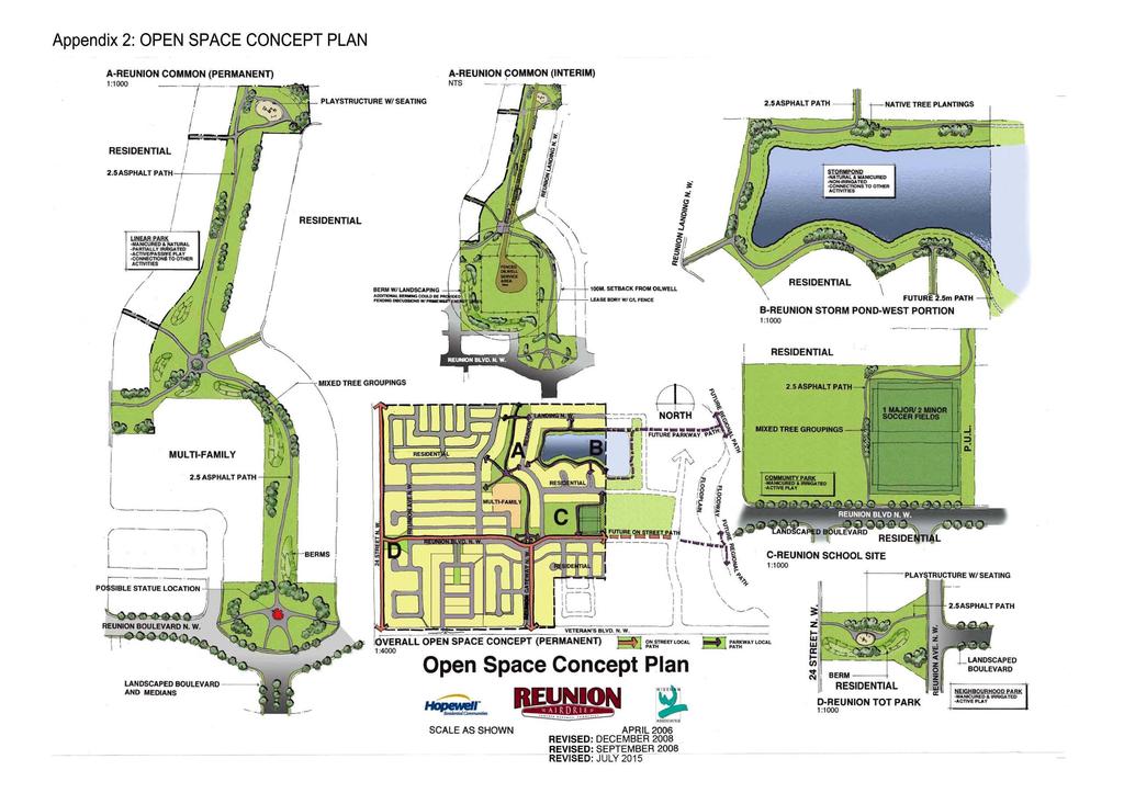
7 Reunion Street, the second entrance road into the Reunion neighborhood of off 24 th Street, terminates into the central open space system which links into the linear open space system to Nose Creek. All residential areas with lanes are proposed to have wider streets with 16.5m right of way allowing for enhanced boulevard landscaping. It is Hopewell s intent to develop a comprehensive package of architectural guidelines to ensure a cohesive and interesting streetscape. A copy of the guidelines package shall be submitted to the City prior to land use approval. The Reunion road layout is efficiently designed to create a modified grid pattern including streets with terminating vistas and strong visual impact. The modified grid pattern allows the traffic to disperse evenly through the streets without overloading the collector roads, giving alternate travel choices to the residents. An integral part of Reunion neighborhood is the range of housing types. to accommodate the needs of a variety of socio-economic groups. The predominant form of housing type will be single family detached residential, which will include a range of lot sizes to provide various levels of affordability. The single family residential will consist of a mix of laned and laneless residential. Two One multifamily residential parcel is proposed within the NSP area, The southern parcel will accommodate senior s complex offering villa-style housing as well as apartment style units providing nursing care. The second multifamily parcel is located within the 100m setback lands and will be developed once the oil well is decommissioned to the satisfaction of the approving authority. It is expected to accommodate street townhouses. The Reunion NSP is anticipated to yield units. The projected density is anticipated to be above 7 units per acre, 6.61 units per acre, complying with the amended density policy of the Airdrie City Plan which indicates a minimum density of 7 units per acre with no specified maximum density marginally below the 7 units per acre density policy of the Airdrie City Plan at the time of original approval of Reunion NSP in The proposed Reunion NSP and accompanying statistics are included within Appendix 1 of this report. A comprehensively designed open space system is a major design component of the Reunion NSP. Neighborhood & sub-neighborhood parks are located at the focal points of key streets to enhance their visual significance. The proposed open space system provides opportunities for active and passive recreation. A system of pathways in the open space and separate sidewalks along key streets provides pedestrian accessibility within 400m walking distance as well as linkages to Nose Creek. The storm retention facility is proposed to be landscaped in naturalized edge and integrated with the open space system as an engineered wetland. It is Hopewell s intent to construct a pathway around the pond within their property. Hopewell will make best efforts to encircle the pond with a trail system on the adjacent parcel to provide connectivity until such time the eastern quarter is developed. Concept plans for each of the open space components have been prepared by Wiseman Associates and are included in Appendix 2 of this report. 15
8 The Reunion NSP can be developed in an efficient and cost effective manner with minimal off-site transportation and servicing costs. Servicing connections are available adjacent to the NSP area within Veterans Boulevard. Both utility servicing and transportation are discussed further in this report. Land Use The proposed land uses for the NSP area consist of single detached residential including laned and laneless lots, low and high density multiple dwellings, a church site and open space uses for parks, schools and storm retention facilities. The uses are summarized in the following table: TABLE 1 PROPOSED LAND USES hectares acres Single detached small lot % Single detached laned % Townhouses % Seniors Complex % Semi-detached % Church % Open space (including PUL) % Roads % TOTAL % Housing Mix The following table identifies the housing mix proposed, based on land use: TABLE 2 PROPOSED HOUSING MIX Units Single detached small lot % Single detached laned % Townhouses % Seniors Complex % Semi-detached % TOTAL % 16
9 The plan area consists of approximately 38% multifamily residential. The larger 12.35ac multifamily site will be geared towards seniors housing incorporating assisted living with nursing care units. The concept is envisaged to include lower density attached villa-type units along the perimeter of the site with higher density structure(s) located centrally within the site. This will allow the seniors to age in place by moving into units with nursing care once they are no longer able to care for themselves. The low profile villa units located along the perimeter of the site will establish a complimentary interface with the adjacent single family residential. The single family residential constitutes approximately 62% of the housing units and consists of a balanced mix of laned and laneless residential. The small lot and laned product will allow single family lots of varying widths, thereby targeting various levels of affordability. One multifamily site is proposed once the oil well setback is no longer a constraint. Density In keeping with the City s objective of intensifying land uses, the overall density of the plan area is projected at 9.01 units per acre. This is in keeping with the 7 units per acre minimum density policy in the Airdrie City Plan, approved by Council on May 5, The density policy as per the Airdrie City Plan, at the time of approval of the NW CASP in 2006 was a range of units per acre and at the time of approval of Reunion NSP was a minimum of 7 units per acre. The proposed 6.61 units per acre density falls within the units per acre range and is marginally below the 7 units per acre minimum requirement. It represents an optimal balance between policy objectives of the Airdrie City Plan and desire of Reunion residents to maintain a compatible development. The following table outlines the projected density: TABLE 3 PROJECTED NSP DENSITY hectares acres Gross Developable Area Total # of units 1, 364 1,001 Density units per acre units per hectare Approximately 35% of the units are clustered on a acre site, allowing the remainder of the land to be developed at a lower density. The density of the Reunion NSP, without the acre seniors complex is projected at 6.36 units per acre as shown in the following table. 17
10 TABLE 4 PROJECTED NSP DENSITY WITHOUT SENIORS COMPLEX hectares acres Gross Developable Area w/out MF Total # of units 884 Density 6.36 units per acre units per hectare 18
11 Oil Well Setback The 100m setback from the active oil well impacts +/-3.14ha (7.76ac) of land within the Reunion NSP. As per the MGA policies, no overnight accommodation or public structure may be located within the setback. The setback lands are proposed to accommodate open space park, single family residential and a multifamily site. In keeping with the policies, open space may be dedicated within the setback while the well is operational. The multifamily site and single family residential located within the setback lands consisting of 2.06ha (5.09ac) are intended to be developed once the oil well site is appropriately decommissioned to the satisfaction of the approving authority. In the interim, the site will be integrated with the surrounding open space. Appendix 2 shows landscape concept plans for both the interim and ultimate scenarios. The setback also impacts the rear yard of a block of laned residential along Reunion Boulevard. In accordance with the MGA policies and the City of Airdrie s interpretation, rear drive garages with no habitable space off the lanes may be located within the setback. Municipal Reserve In accordance with the Municipal Government Act, 10% municipal reserve is provided within the lands covered by the NSP. It is assumed that 10% reserve owing on the Shadow Plan lands will be provided at the time of subdivision of those lands. The Reunion NSP will include 10.3% municipal reserve (not including the shadow plan lands), marginally in excess of the 10% municipal reserve requirement as per the Municipal Government Act (MGA). It is assumed that 10% reserve owing on the Shadow Plan lands will be provided at the time of subdivision of those lands. The excess municipal reserve is voluntary. The Municipal Reserve Analysis for the NSP lands is as follows: TABLE 4 PROPOSED MUNICIPAL RESERVE hectares acres Joint Use Site Westerly Neighborhood Park Southern Park Central Neighborhood Park and linear linkages Area around the storm retention facility Total Municipal Reserve Percentage of Gross Developable lands 10.3% Approximately 0.79 ha (1.95 ac) or 1.3% of the municipal reserve is located within the 100m oil well setback and pipeline. As per the MGA and AEUB (ERCB) policies, municipal reserve for open space may be dedicated within the lands impacted by the setback. It is Hopewell s intent to develop the open space dedicated within the setback lands in conjunction with the adjacent development to ensure amenities are available to the residents at the onset of the development. 19
12 TRANSPORTATION Traffic Impact Assessment The Reunion NSP is bounded by major roads to the west and south, providing the plan area with good access opportunities. Veterans Boulevard, located along the south boundary of the site is a major road and forms part of the provincial highway system. Additional widening on the north side of Veterans Boulevard may be required pending the City Transportation study results. 24 th Street, a future major road, is located along the west boundary. Main access into the development shall be off of Veterans Boulevard in alignment with Woodside Boulevard NW with an additional right-turns only access to the west. A second access is proposed off of 24 th Street. An additional access into the plan area is from the east through the internal collector system within the NW CASP area. The proposed plan makes provision for vehicular connectivity into potential future growth corridor identified to the north. The internal collector system is looped to enable good transit coverage in the future and to allow for a comprehensive roadway system within the Reunion NSP area. The roads are laid out in a modified grid setting, which allows the traffic to disperse without overloading the collectors, at the same time providing alternate route choices to the residents. A Traffic Impact Assessment (TIA), prepared by Bunt and Associates, identifies the improvements along the perimeter roads as well as standard for internal roads based on the proposed land uses within the Reunion NSP. Reunion Gateway, the main entrance road into the NSP area, is proposed as 2x7/27m divided primary collector road. Based on the proposed cross-section, it can accommodate up to 10,000 vpd and is adequate for the projected volume on this street. Reunion Boulevard, the east-west spine road, is projected to have volumes in the order of 3,000 vpd, thereby requiring a 9.8/19.3m Avenue standard road. However, this road is slated to be part of the possible future transit route thereby requiring a collector road. A modified cross-section of 10.5/21m is proposed for Reunion Boulevard and is included in Appendix 4. The intent is to create a wider boulevard than the standard 11.5/21m collector standard road which would allow enhanced pedestrian environment through boulevard landscaping. Reunion Street, entrance road off of 24 th Street, is proposed as 11.5/21m collector standard road. Residential roads within the laned portion of the single family residential are proposed to have a wider right of way, 9.5/16.5m to allow for enhanced boulevard landscaping. The remainder of the roads within the plan area, are typical 9.5/15m residential standard roads. Transit Servicing It is City of Airdrie s intent to provide transit service in the future in accordance with the City s Transit Master Plan. The proposed collector route system enables the opportunity to provide transit service within the Reunion neighborhood in the future achieving coverage within 400m radius. Appendix 5 shows potential transit coverage for the area. 21
13 CONFORMITY TO APPROVED PLANNING DOCUMENTS Airdrie Municipal Development Plan (Airdrie City Plan) Airdrie Municipal Development Plan Bylaw B-04/2004 was adopted by City Council in February Integral to the City s Growth Management approach is the commitment to working towards the triple bottom line of the 21 st century; social well-being, environmental responsibility and fiscal accountability. Subsequent sections of the MDP list policies to achieve this overall philosophy. The following are applicable to the Reunion NSP. 1-1B.1 Working in co-operation with various government agencies, non-profit organizations and the private sector, the City shall endeavor to plan for a wide range of housing which meets the needs of various socio-economic groups, seniors and the handicapped. The Reunion NSP includes a range of housing types to address the needs of various socio-economic groups. In addition to a variety of single and multifamily residential, a 12.35ac site is proposed to accommodate a seniors complex within the plan area. 1-1B.3 The City encourages developers to establish design guidelines and architectural controls for housing developments, which enhance interaction and communication, provide a sense of community and are pedestrian friendly. It is Hopewell s intent to develop Reunion as a neighborhood with its own identity and sense of place. To this end, Hopewell is proposing architectural guidelines to be followed by all the builders within Reunion. A separate guidelines booklet shall be submitted to the City prior to land use approval. It is anticipated that the proposed comprehensive open space system in Reunion will enhance interaction and communication among Reunion residents providing a sense of community. A modified cross-section, with wider boulevards and enhanced landscaping in order to create a pedestrian friendly environment, is proposed for Reunion Boulevard and will be further explored at the detailed design stage. The residential streets for laned lots are 16.5m wide to enable plantation of street trees thereby enhancing the pedestrian environment. The plan makes provisions for comprehensive open space and pedestrian linkages to neighborhood parks, school sites and Nose Creek within 400m of residential development Developers shall be required to demonstrate how proposed construction projects and new developments contribute to community health, utilize environmentally sound practices and conserve resources. 25
14 Hopewell intends to follow industry established construction practices to regulate and control surface runoff. The Reunion NSP incorporates a storm retention facility to control both the quality and quantity of runoff into Nose Creek. The intent is to naturalize the facility and incorporate it into the open space system to further enhance the environment The City shall endeavor to retain and improve the natural functions and habitat as well as improve the recreational and scenic qualities of watercourses. The NW CASP proposes regional pathways on both the east and west of Nose Creek to enhance its recreational quality The initial cost of roads, sidewalks, water sewer, sanitary and shallow utility requirements in new development areas shall be borne by the proponent of such development Future development shall be permitted only in locations that can be accommodated by logical extensions of the municipal infrastructure The NW CASP as well as the Reunion NSP are identified as cost effective growth areas due to minimal off-site infrastructure cost. Hopewell Residential shall pay for necessary extension of services. The logical progression of development shall occur from south to north In keeping with the City s fiscal, environmental and land use goals, the City shall ensure through CASPs and NSPs that new communities and neighbourhoods become more sustainable by adhering to the following principles: Residential land uses shall achieve a minimum density of 7.0 units per net developable acre within all new Neighbourhood Structure Plan areas. Providing livable and healthy communities that include a mixture of single and multi-unit dwelling types, densities and land uses. Ensuring a more compact urban form that more efficiently utilizes land and infrastructure. Creating areas of higher residential density to take advantage of alternate modes of transportation (i.e. walking, cycling, transit, etc.) and thus reducing the reliance on the private automobile. Ensuring through sound community and neighbourhood design, the development of pedestrian friendly communities and neighbourhoods (providing for and encouraging alternative modes of transport), reducing the reliance on the private automobile. The Reunion NSP proposes a density of 9.01 upa, which is above the minimum density of 7.0 upa specified in the density policy amendment in the Airdrie City Plan which was approved on May 5, 2008 and attached in the Appendices. This is in keeping with the principles for a mixture of single and multi-unit dwelling types, and densities for a more compact and efficient urban form. The Reunion NSP attains a density of 6.61 units per acre which falls within the units per acre range that 27
15 the Reunion NSP was originally approved, and is only marginally less than the 7.0 units per acre requirement in the Airdrie City Plan A high standard of visual amenity shall be incorporated into all new development areas by capitalizing on varied visual impressions produced by such features as road configuration, integrated open space, and sensitive use of building materials, or colours, landscaping and architectural styles. A key element of the Reunion NSP is creation of layout where key streets terminate into open space areas. These open space components are proposed to have elements such as gazebos, public art and outdoor activities which will become both visual and social focus, thereby creating an enhanced visual impact. It is Hopewell s intent to implement architectural controls relative to materials, colours, landscaping and architectural styles, in order to create visually pleasing streetscapes Housing developments that provide a range of lifestyles and work alternatives are encouraged. The Reunion NSP includes a range of housing types, including a seniors complex providing assisted living with nursing care The range, style and type of single dwelling development shall be approved in Neighbourhood Structure Plans and may be dependent on the inclusion of design features such as, but not limited to: Paved lanes, parking pads and driveways Architectural controls; Varied front yard setbacks; Uniform perimeter fencing including rear garbage enclosures; Separated sidewalks and landscaped boulevards; Entrance treatments; Open space; Rear attached/detached garages Landscape plan The above components shall be addressed as part of the comprehensive architectural guidelines package prepared by Hopewell Residential Communities, and submitted to the City prior to land use approval Small lot detached housing may be allowed provided that such lots form part of an approved comprehensively designed development area, taking into account location, clustering, servicing capacity and the development of a socially cohesive community Medium density attached housing developments are encouraged to develop as part of the overall low density development in a manner which blends with, and enhances surrounding land uses. 28
16 Northwest Community Area Structure Plan (NW CASP) The proposed Reunion NSP complies with the following policies contained within the NW CASP. Policies 2.3.1, and All addressed as per the policy direction Policy The proposed development within the 100m oil well setback is in accordance with the MGA, with further clarification from AEUB (ERCB) and the City of Airdrie. No development that results in overnight accommodation will be implemented while the well is active. Only open space, rear yards and garages will be developed within the setback lands. The multifamily site and single family residential located within the setback lands will be developed once the well is decommissioned to the satisfaction of the approving authority. No portion of the proposed joint use site is impacted by the oil well setback. Policy The proposed development is in accordance with the direction set out in Airdrie GAMP. As per the GAMP, the proposed development is primarily residential, including a mix of unit types. Access points are aligned with the existing access points to the south on Veterans Boulevard. The existing oil well is appropriately addressed. Policies 3.3.1, & The previous sections address compliance of the plan to the Airdrie City Plan as well as the City of Airdrie/MD of Rocky View IDP. Policy 4.1 and 4.3 The proposed residential uses, which interface with Woodside and Silver Creek are compatible in terms of nature and intensity to the existing uses. To the north and west, the proposed residential is expected to have minimal impact on the existing agricultural uses with respect to odours, noise, etc. Policy The proposal consists of single family residential with a wide range of lot sizes addressing various levels of affordability. A ac multifamily site is proposed for seniors including assisted living with nursing care units. One multifamily site is proposed as part of the future development. 33
17 Policy The Reunion NSP makes provision for the 7.98 ac parcel located to the southeast to be developed to urban densities and ensures access and servicing tie-ins. Policy 5.3.1, and The overall density is addressed within section Density of this report. The plan area consists of a variety of housing types, which is addressed in section Housing Mix of this report. The pattern of residential uses generally conforms to Figure 7 Development Plan contained with the NW CASP. Policy The acre, higher density multifamily site, will be designed to create a sensitive interface with the surrounding single family residential. It is intended to have lower density villas along the perimeter of the site and higher intensity building structures with nursing units located centrally. The 3.21ac lower density multifamily is intended to have street townhouses which are deemed to be compatible with the adjacent single family residential and open space. Policy 5.4.1, and The plan area exceeds 10% Municipal Reserve (MR) required as per the MGA. In accordance with the MGA 10% of the gross developable area is dedicated as municipal reserve for the NSP lands. It is assumed that 10% MR owing in the Shadow Plan lands will be dedicated upon subdivision of those lands. The proposed open space provides opportunities for both active and passive recreation. Tot lots and playfields shall be provided within neighborhood parks and the joint use site. The naturalized storm retention facility and pathway system provide opportunities for passive recreation. Policy Approximately 1.3% or 1.95 ac of the Municipal reserve owing on the Reunion NSP is located with the 100m setback from the oil well. In accordance with the MGA and AEUB policies, the setback lands may be dedicated for open space uses. With the exception of a small leased area including 0.15ha (0.37ac), it is Hopewell s intent to develop the municipal reserve located within the setback lands in conjunction with the development on adjacent lands. Hopewell will enter into an agreement with the City to develop the leased portion, once the well is decommissioned. 34

18 0m 25m 50m 75m 100m
19
20
21
Bylaw No. B-03/2011 Adopted by Airdrie City Council February 21, 2012
 COOPER S CROSSING STAGE 4 Neighbourhood Structure Plan City of Airdrie WESTMARK HOLDINGS LTD. Bylaw No. B-03/2011 Adopted by Airdrie City Council February 21, 2012 CONSULTANTS: LAND USE PLANNING: Southwell
NEIGHBOURHOOD STRUCTURE PLAN
 NEIGHBOURHOOD STRUCTURE PLAN December 2012 2437.0023.06 This report is prepared for the sole use of Vesta Properties Ltd. No representations of any kind are made by Urban Systems Ltd. or its employees
City of Grande Prairie Development Services Department
 City of Grande Prairie Development Services Department ROYAL OAKS NORTH OUTLINE PLAN OP-07-03 NW 35-71-6 W6M May 7, 2007 Royal Oaks North Outline Plan TABLE OF CONTENTS 1.0 INTRODUCTION........ 3 1.1 Purpose
ADMINISTRATION RECOMMENDATION 2016 November 03. That Calgary Planning Commission recommends APPROVAL of the proposed Land Use Amendment.
 Page 1 of 12 EXECUTIVE SUMMARY This Land Use Amendment application covers an area of 75.76 hectares ± (187.20 acres ±) located in northeast Calgary, bound by Stoney Trail NE to the north, 128 Avenue NE
LAND USE AMENDMENT CORNERSTONE (WARD 3) COUNTRY HILLS BOULEVARD AND STONEY TRAIL NE BYLAW 9D2017
 COUNTRY HILLS BOULEVARD AND STONEY TRAIL NE BYLAW 9D2017") Page 1 of 12 EXECUTIVE SUMMARY This Land Use Amendment application covers an area of 54.92 hectares ± (135.71 acres ±) located in northeast Calgary, bound by Country Hills Boulevard NE to the north and
Page 1 of 12 EXECUTIVE SUMMARY This Land Use Amendment application covers an area of 54.92 hectares ± (135.71 acres ±) located in northeast Calgary, bound by Country Hills Boulevard NE to the north and
Bylaw C-1186 Adopted November 5, Planning and Development Services
 Bylaw C-1186 Adopted November 5, 2007 Planning and Development Services CITY OF GRANDE PRAIRIE OFFICE CONSOLIDATION BYLAW C-1186 A Bylaw to adopt the Westgate Area Structure Plan (As Amended by Bylaw C-1186-1,
Westwind Developments Ltd. PIONEER LANDS AREA STRUCTURE PLAN - PROPOSED AMENDMENT
 FEBRUARY 2013 TABLE OF CONTENTS 1.0 BACKGROUND... 1 1.1 Amendment... 1 2.0 LOCATION & CONTEXT... 2 2.1 Land Ownership... 2 3.0 POLICY CONTEXT... 3 3.1 Municipal Development Plan... 3 3.2 Capital Region
OP Council Resolution June 16, Planning and Development Services
 OP-08-01 Council Resolution June 16, 2008 Planning and Development Services Kingsgate Landing Outline Plan Table of Contents 1.0 Introduction 1 1.1 Purpose of Plan 1 1.2 Plan Area Location 1 1.3 Ownership
Outline Plan in Belvedere (Ward 9) at Street SE, LOC (OP)
 at Street SE, LOC (OP)") 2018 October 04 Page 1 of 12 EXECUTIVE SUMMARY This outline plan application was submitted by B&A Planning Group on 2016 July 15, on behalf of Tristar Communities Inc. for 50.14 hectares (123.89 acres)
2018 October 04 Page 1 of 12 EXECUTIVE SUMMARY This outline plan application was submitted by B&A Planning Group on 2016 July 15, on behalf of Tristar Communities Inc. for 50.14 hectares (123.89 acres)
URBAN DESIGN BRIEF. 2136&2148 Trafalgar Road. Town of Oakville
 URBAN DESIGN BRIEF 2136&2148 Trafalgar Road Town of Oakville Prepared By: METROPOLITAN CONSULTING INC For 2500674 Ontario Inc November 2016 TABLE OF CONTENTS Page No. 1.0 Introduction/Description of Subject
LAND USE AMENDMENT CORNERSTONE (WARD 3) 60 STREET NE AND COUNTRY HILLS BOULEVARD NE MAP 26NE BYLAW 22D2017
 60 STREET NE AND COUNTRY HILLS BOULEVARD NE MAP 26NE BYLAW 22D2017") Page 1 of 14 EXECUTIVE SUMMARY This Land Use Amendment application covers an area of 43.76 hectares ± (108.14 acres ±) located in northeast Calgary, bound by Country Hills Boulevard NE to the south and
Page 1 of 14 EXECUTIVE SUMMARY This Land Use Amendment application covers an area of 43.76 hectares ± (108.14 acres ±) located in northeast Calgary, bound by Country Hills Boulevard NE to the south and
ROAD CLOSURE AND LAND USE AMENDMENT SILVER SPRINGS (WARD 1) NORTHEAST OF NOSEHILL DRIVE NW AND SILVER SPRINGS ROAD NW BYLAWS 2C2018 AND 29D2018
 NORTHEAST OF NOSEHILL DRIVE NW AND SILVER SPRINGS ROAD NW BYLAWS 2C2018 AND 29D2018") Page 1 of 19 EXECUTIVE SUMMARY This application proposes redesignating two parcels in the community of Silver Springs from Special Purpose Future Urban Development (S-FUD) District and undesignated road
Page 1 of 19 EXECUTIVE SUMMARY This application proposes redesignating two parcels in the community of Silver Springs from Special Purpose Future Urban Development (S-FUD) District and undesignated road
City of Grande Prairie Development Services Department KENNEDY DEVELOPMENTS LTD. OUTLINE PLAN OP-09-01
 City of Grande Prairie Development Services Department KENNEDY DEVELOPMENTS LTD. OUTLINE PLAN OP-09-01 July 27, 2009 TABLE OF CONTENTS 1.0 Introduction... 1 1.1 Plan Area Location & Context... 1 1.2 Ownership
Bylaw C-1262 Adopted February 6, Planning and Development Department
 Bylaw C-1262 Adopted February 6, 2012 Planning and Development Department CITY OF GRANDE PRAIRIE BYLAW C-1262 A Bylaw to adopt the Brookfield Neighbourhood Outline Plan THE MUNICIPAL COUNCIL OF THE CITY
Palisades Outline Plan
 NE ¼ 25 36 28 W4 Town of Penhold Approved August 13, 2012 Contents Figures & Tables... 2 Introduction... 1 Overview... 1 Purpose... 1 Development Area... 3 Ownership... 3 Topography... 3 Existing & Surrounding
AREA STRUCTURE PLAN NE W5M. Adopted by Council September 27, 2010 Bylaw
 AREA STRUCTURE PLAN NE 5-33-1 W5M Adopted by Council September 27, 2010 Bylaw 2010-14 CONTENTS 1.0 Introduction... 3 1.1 Purpose... 3 1.2 Objectives... 3 1.3 Discovery Plains Community Vision... 3 1.3.1
East Bayshore Road Neighbourhood
 East Bayshore Road Neighbourhood Northridge Property Management Urban Design Brief 3195 East Bayshore Road City of Owen Sound January 2016 East Bayshore Road Neighbourhood Northridge Property Management
C ity of Grande Prairie Development Services Department
 C ity of Grande Prairie Development Services Department FAIRWAY DEVELOPMENT OUTLINE PLAN OP 08 09 Approved April 6, 2009 Prepared by: Focus Corporation Table of Contents 1.0. Introduction 2 3 1.1. Plan
Airdrie, Alberta KING S HEIGHTS. NEIGHBOURHOOD STRUCTURE PLAN and LAND USE REDESIGNATION Supporting Documentation. Prepared for
 Airdrie, Alberta KING S HEIGHTS NEIGHBOURHOOD STRUCTURE PLAN and LAND USE REDESIGNATION Supporting Documentation Prepared for Highview Communities Inc. West 33 Developments Ltd. City of Airdrie Prepared
FORMER CANADIAN FORCES BASE (CFB) ROCKCLIFFE SECONDARY PLAN. Official Plan Amendment XX to the Official Plan for the City of Ottawa
 ROCKCLIFFE SECONDARY PLAN. Official Plan Amendment XX to the Official Plan for the City of Ottawa") FORMER CANADIAN FORCES BASE (CFB) ROCKCLIFFE SECONDARY PLAN Official Plan Amendment XX to the Official Plan for the City of Ottawa 1 INDEX THE STATEMENT OF COMPONENTS PART A THE PREAMBLE PAGE Purpose...
FORMER CANADIAN FORCES BASE (CFB) ROCKCLIFFE SECONDARY PLAN Official Plan Amendment XX to the Official Plan for the City of Ottawa 1 INDEX THE STATEMENT OF COMPONENTS PART A THE PREAMBLE PAGE Purpose...
EXHIBIT B PROJECT NARRATIVE POULSBO MEADOWS
 EXHIBIT B PROJECT NARRATIVE POULSBO MEADOWS Name of Project: Poulsbo Meadows; A Planned Residential Development (PRD)/Plat Applicants Name: PBH Group LLC/Byron Harris PO Box 1010 Silverdale, WA 98038 Description
This application has been applied for with support of an Outline Plan to provide the technical details for the site s development.
 Page 1 of 13 EXECUTIVE SUMMARY This application consists of a Land Use Amendment application proposing redesignation from Special Purpose Future Urban Development (S-FUD) District to an assortment of multiresidential,
THE CITY OF SPRUCE GROVE BYLAW C PIONEER LANDS AREA STRUCTURE PLAN AMENDMENT
 THE CITY OF SPRUCE GROVE BYLAW C-932-15 PIONEER LANDS AREA STRUCTURE PLAN AMENDMENT WHEREAS, pursuant to the Municipal Government Act, R.S.A. 2000, c. M-26, including amendments, a municipality may adopt
URBAN DESIGN BRIEF 305, 309, & 315 SOUTHDALE ROAD WEST LONDON ONTARIO
 URBAN DESIGN BRIEF 305, 309, & 315 SOUTHDALE ROAD WEST LONDON ONTARIO CARVEST PROPERTIES LTD. December 2013 Section 1 - Land Use Planning Context 1.1 Subject Lands The subject lands are located immediately
POLICY AMENDMENT AND LAND USE AMENDMENT KILLARNEY/GLENGARRY (WARD 8) NW CORNER OF RICHMOND ROAD AND 33 STREET SW BYLAWS 1P2015 AND 7D2015
 NW CORNER OF RICHMOND ROAD AND 33 STREET SW BYLAWS 1P2015 AND 7D2015") Page 1 of 13 EXECUTIVE SUMMARY This application seeks to redesignate an RC-2 (Residential Contextual One/Two Dwelling) parcel to MC-Gd72 (Multi-Residential Contextual Grade-Oriented) to allow for multi-residential
Page 1 of 13 EXECUTIVE SUMMARY This application seeks to redesignate an RC-2 (Residential Contextual One/Two Dwelling) parcel to MC-Gd72 (Multi-Residential Contextual Grade-Oriented) to allow for multi-residential
URBAN DESIGN BRIEF URBAN DESIGN BRIEF 721 FRANKLIN BLVD, CAMBRIDGE August 2018
 URBAN DESIGN BRIEF URBAN DESIGN BRIEF 721 FRANKLIN BLVD, CAMBRIDGE August 2018 DESIGN BRIEF CONTENTS PART A 1.0 INTRODUCTION 2.0 DESCRIPTION & ANALYSIS OF SITE CONTEXT 3.0 DESIGN CONSTRAINTS AND OPPORTUNITIES
WEST HILL BUSINESS PARK AREA STRUCTURE PLAN
 MUNICIPAL DISTRICT OF PEACE NO. 135 WEST HILL BUSINESS PARK AREA STRUCTURE PLAN Prepared by: TABLE OF CONTENTS 1.0 Introduction... 1 1.1 Purpose of Plan........ 1 1.2 Plan Area..... 1 1.3 Existing Conditions...
S o u t h C e n t r a l O u t l i n e P l a n. Leduc Business Park. North Leduc Industrial Area Structure Plan C it y of Led u c.
 Leduc Business Park North Leduc Industrial Area Structure Plan C it y of Led u c Prepared for Farm Air Properties Inc. January, 2007 Table of Contents Page Number 1.0 Purpose of Plan and Definition of
ADMINISTRATION RECOMMENDATION(S) 2017 June 15. That Calgary Planning Commission recommends APPROVAL of the proposed Land Use Amendment.
 2017 June 15. That Calgary Planning Commission recommends APPROVAL of the proposed Land Use Amendment.") Page 1 of 7 EXECUTIVE SUMMARY The proposed land use amendment seeks to redesignate a Special Purpose Future Urban Development (S-FUD) District parcel in Residual Ward 3 Sub Area 3H to Industrial Outdoor
Page 1 of 7 EXECUTIVE SUMMARY The proposed land use amendment seeks to redesignate a Special Purpose Future Urban Development (S-FUD) District parcel in Residual Ward 3 Sub Area 3H to Industrial Outdoor
Red Fox Commercial Outline Plan
 Red Fox Commercial Outline Plan City of Cold Lake, Alberta Prepared by Durrance Projects Ltd and Ross W. Sharp & Associates Ltd October 2014 Rupert 1 Table of Contents 1. PURPOSE...3 1.1. Location...4
Municipal Development Plan. Summer Village of ROCHON SANDS. Bylaw #241-18
 Municipal Development Plan Summer Village of ROCHON SANDS Bylaw #241-18 TABLE OF CONTENTS PART ONE: BACKGROUND AND PURPOSE 3 SECTION 1: BACKGROUND 3 SECTION 2: GOALS AND POLICIES 3 PART TWO: PHYSICAL ENVIRONMENT
Urban Design Brief Proposed Residential Development 5219 Upper Middle Road City of Burlington
 Urban Design Brief Proposed Residential Development 5219 Upper Middle Road City of Burlington Prepared by Weston Consulting Prepared for BLOOMFIELD DEVELOPMENT INC. Date: March 2017 Table of Contents 1.
The Uplands Area Structure Plan. City of Cold Lake, NE & SE W4
 City of Cold Lake, NE & SE 13-63-2-W4 July 2009 1 Contents 1 Background information... 1 1.1 Foreword... 1 1.2 Purpose... 1 1.3 Plan Area and Location... 1 1.4 Ownership... 2 2 Factors Influencing Development...
PORT WHITBY COMMUNITY
 PORT WHITBY COMMUNITY SECONDARY PLAN UPDATE COMMUNITY IMPROVEMENT PLAN URBAN DESIGN GUIDELINES September 2015 DRAFT PROPOSED AMENDMENT NUMBER # to the Whitby Official Plan PURPOSE: The intent of this Amendment
2136 & 2148 Trafalgar Road Town of Oakville Region of Halton
 PLANNING JUSTIFICATION REPORT 2136 & 2148 Trafalgar Road Town of Oakville Region of Halton Zoning By-Law Amendment Application 2500674 Ontario Inc. November 2016 Table of Contents Page 1.0 Location/Summary
Bylaw 884/13 Schedule A. Town of Rimbey. June 2008.
 Bylaw 884/13 Schedule A Town of Rimbey June 2008. Revised April 2013 Bylaw 884/13 Schedule A Johnson Estates Table of Contents 1. Introduction... 11 1.1 Purpose... 11 1.2 Location Context... 11 1.3 Land
Land Use Amendment in Southwood (Ward 11) at and Elbow Drive SW, LOC
 at and Elbow Drive SW, LOC") 2018 November 15 Page 1 of 10 EXECUTIVE SUMMARY This land use amendment application was submitted by Rick Balbi Architect on 2017 August 31 on behalf of Sable Developments Ltd, and with authorization from
2018 November 15 Page 1 of 10 EXECUTIVE SUMMARY This land use amendment application was submitted by Rick Balbi Architect on 2017 August 31 on behalf of Sable Developments Ltd, and with authorization from
Description of Preferred Alternative
 Chapter 2 Description of Preferred Alternative 2.1 Introduction This chapter of the programmatic Sammamish Town Center Sub-area Plan Final EIS provides a more detailed description of the Preferred Alternative
ADMINISTRATION RECOMMENDATION(S) 2017 February 09. That Calgary Planning Commission recommends APPROVAL of the proposed Land Use Amendment.
 2017 February 09. That Calgary Planning Commission recommends APPROVAL of the proposed Land Use Amendment.") Page 1 of 10 EXECUTIVE SUMMARY This land use amendment application is to accommodate changes to the location of a stormwater retention pond and land use boundaries adjacent to Environmental Reserve in
Page 1 of 10 EXECUTIVE SUMMARY This land use amendment application is to accommodate changes to the location of a stormwater retention pond and land use boundaries adjacent to Environmental Reserve in
5.0 Community Design Plan
 5.0 Community Design Plan The Community Design Plan for the Mer Bleue area is a composite of three plans: Land Use Plan Transportation Plan Municipal Servicing Plan Read together, these Plans and associated
Gold Line Bus Rapid Transit Transit Oriented Development (BRTOD) Helmo Station Area Plan
 Helmo Station Area Plan") Appendix F Gold Line Bus Rapid Transit Transit Oriented Development (BRTOD) Helmo Station Area Plan Introduction and Purpose of the Plan The Gold Line Bus Rapid Transit facility is an eleven-mile dedicated
Appendix F Gold Line Bus Rapid Transit Transit Oriented Development (BRTOD) Helmo Station Area Plan Introduction and Purpose of the Plan The Gold Line Bus Rapid Transit facility is an eleven-mile dedicated
BRIDGES OF LANGDON CONCEPTUAL SCHEME
 BRIDGES OF LANGDON CONCEPTUAL SCHEME Office Consolidation This page contains the history of relevant bylaws affecting this office consolidation. A copy of the original Bylaw and all amending Bylaws can
CONTENTS 8.0 LAND USE 8.1 GENERAL LAND USE 8.2 RESIDENTIAL 8.3 MIXED USE 8.4 COMMERCIAL 8.5 EMPLOYMENT LANDS
 8-2 Land Use 8.0 LAND USE CONTENTS 8.1 GENERAL LAND USE 8.1.1 Uses provided for in all Land Use Designations 8.1.2 Uses prohibited in Hazardous Lands, Hazardous Sites and Special Policy Areas 8.1.3 Uses
Leduc Industrial Outline Plan SE W4
 Leduc Industrial Outline Plan SE 1-50-25-W4 Within the North Leduc Industrial ASP Prepared for: Leduc Energy Park Ltd. Prepared by: Stantec Consulting Ltd. File No. 1161 104655 V5 Table of Contents 1.0
URBAN DESIGN BRIEF. Saginaw Subdivision 124 SAGINAW PARKWAY, CAMBRIDGE OCTOBER 2015 OUR FILE 1422A
 URBAN DESIGN BRIEF Saginaw Subdivision 124 SAGINAW PARKWAY, CAMBRIDGE OCTOBER 2015 OUR FILE 1422A Contents 1.0 INTRODUCTION AND SITE DESCRIPTION... 1 2.0 MUNICIPAL DESIGN DIRECTION... 7 3.0 MASTER CONCEPT
Gateway commercial MIXED USE MASTER SITE PLAN. CITILAND AIrDRIE GATEWAY VENTURE INC. airdrie GATEWAY COMMERCE CENTRE. airdrie, ALBERTA FEBRUARY 2012
 Gateway commercial MIXED USE MASTER SITE PLAN 1914 CENTRE STREET NORTH CALGARY, AB CANADA T2E 2S8 T. 403.264.7177 F. 403.264-7175 WWW.CITILAND.CA CITILAND AIrDRIE GATEWAY VENTURE INC. airdrie GATEWAY COMMERCE
FROM: General Manager, Planning and Development FILE: (North Grandview Heights)
") Corporate NO: C009 Report COUNCIL DATE: May 18/05 COUNCIL-IN-COMMITTEE TO: Mayor & Council DATE: May 12, 2005 FROM: General Manager, Planning and Development FILE: 6520-20 (North Grandview Heights) SUBJECT:
Corporate NO: C009 Report COUNCIL DATE: May 18/05 COUNCIL-IN-COMMITTEE TO: Mayor & Council DATE: May 12, 2005 FROM: General Manager, Planning and Development FILE: 6520-20 (North Grandview Heights) SUBJECT:
Complete Neighbourhood Guidelines Review Tool
 Complete Neighbourhood Guidelines Review Tool Prepared By: City of Regina Planning Department October 2014 Page 1 of 14 Community Development Review Checklist for Secondary Plans and Concept Plans The
March 21, 2018 ALCA Meeting. March 21, 2018
 March 21, 2018 ALCA Meeting March 21, 2018 Agenda 1. Process and Timeline 2. Original Submission 3. Revised Submission 4. Next Steps The City of Calgary Role: The City is responsible for capturing and
TABLE OF CONTENTS. Sierra Springs Outline Plan
 Sierra Springs Outline Plan TABLE OF CONTENTS 1. Introduction...3 1.1. Purpose of the Plan... 3 1.2. The Approval Process... 3 1.3. Policy and Legislative Framework... 3 2. Development Area...6 2.1. Location
Arbour Lake Development Application
 Arbour Lake Development Application This public engagement session is intended to share information about the proposal to develop the Hawkwood Farm, answer questions and collect feedback on various parts
Bressa Developments Limited. Planning Justification Report. Revised Draft Plan of Subdivision and Zoning By-Law Amendment
 Bressa Developments Limited Revised Draft Plan of Subdivision and Zoning By-Law Amendment Planning Justification Report Part of Lots 7 & 8 Concession 1, North of Dundas Street Town of Oakville September,
ADMINISTRATION RECOMMENDATION(S) 2016 November 03. That Calgary Planning Commission recommends APPROVAL of the proposed Land Use Amendment.
 2016 November 03. That Calgary Planning Commission recommends APPROVAL of the proposed Land Use Amendment.") Page 1 of 7 EXECUTIVE SUMMARY This Land Use Amendment application seeks to redesignate a portion of the parcel from Industrial General (I-G) District to Special Purpose City and Regional Infrastructure
Page 1 of 7 EXECUTIVE SUMMARY This Land Use Amendment application seeks to redesignate a portion of the parcel from Industrial General (I-G) District to Special Purpose City and Regional Infrastructure
GATEWAY AREA STRUCTURE PLAN
 CHESTERMERE GATEWAY AREA STRUCTURE PLAN COMMUNITY OPEN HOUSE SEPTEMBER 22 nd, 2015 PLAN AREA ± 512 hectares (± 1,265 acres) GATEWAY LOCATION UNDEVELOPED LANDS PRESENT AGRICULTURAL USE REGIONAL LAND USE
Urban Design Brief. Watson Parkway North & Watson Road North Guelph, Ontario. Prepared by Coletara Development
 Urban Design Brief Watson Parkway North & Watson Road North Guelph, Ontario Prepared by Coletara Development December, 2013 Urban Design Brief, Coletara Development 1 Introduction This Urban Design Brief
North Oakville East Parks Facilities Distribution Plan. November, 2009
 North Oakville East November, 2009 POLICY CONTEXT 1) Purpose a) The purpose of this document is to be a guide for the location, configuration, design and development of the parks system for the North Oakville
Central and East Neighbourhoods - Hermitage Outline Plan
 Central and East Neighbourhoods - Hermitage Outline Plan Office Consolidation September 2013 Prepared by: Planning and Policy Services Branch Planning and Development Department City of Edmonton The Central
HURON COMMUNITY PLAN
 CITY OF KITCHENER DEPARTMENT OF DEVELOPMENT AND TECHNICAL SERVICES PD 94/7 HURON COMMUNITY PLAN Recommended by Planning and Economic Development Committee: October 31, 1994 Adopted by Kitchener City Council:
RESIDENTIAL PLANNED UNIT DEVELOPMENT / SUBDIVISION AND REZONING CONCEPT AND DEVELOPMENT STAGE PLAN SUBMITTAL NARRATIVE
 RESIDENTIAL PLANNED UNIT DEVELOPMENT / SUBDIVISION AND REZONING CONCEPT AND DEVELOPMENT STAGE PLAN SUBMITTAL NARRATIVE DEVELOPMENT TEAM DONEGAL SOUTH Maple Grove, Minnesota March 27, 2017 Applicant/Developer/Builder:
E. RURAL COMMERCIAL/INDUSTRIAL PARK MODEL
 E. RURAL COMMERCIAL/INDUSTRIAL PARK MODEL 1. PURPOSE The purpose of the Rural Commerce/Industrial Park Model is to provide parameters within which a grouping of business buildings with parking, loading
ARTICLE 6: Special and Planned Development Districts
 ARTICLE 6: Special and Planned Development Districts 6-10 Traditional Neighborhood Development (TND) District 6-10.10 Purpose and Intent The Traditional Neighborhood Development (TND) District provides
BYLAW C A Bylaw of Rocky View County to amend Land Use Bylaw C
 BYLAW C-7720-2017 A Bylaw of Rocky View County to amend Land Use Bylaw C-4841-97. The Council of Rocky View County enacts as follows: PART 1 TITLE This Bylaw shall be known as Bylaw C-7720-2017. PART 2
3. VISION AND GOALS. Vision Statement. Goals, Objectives and Policies
 Vision Statement Queen Creek s interconnected network of parks, trails, open spaces and recreation opportunities provide safe and diverse activities and programs that sustain its unique, small town, equestrian
Urban Design Brief. 583, 585 and 589 OXFORD STREET EAST. Salt Clinic Canada Inc.
 Urban Design Brief 583, 585 and 589 OXFORD STREET EAST Salt Clinic Canada Inc. February 3, 2013 TABLE OF CONTENTS Page No. INTRODUCTION... 1 SECTION 1 LAND USE PLANNING CONCEPT... 1 1.1 The Subject Property...
6.0 Land Use Policies for Rural Settlements. 6.1 Rural Settlement Strategy
 6.0 Land Use Policies for Rural Settlements 6.1 Rural Settlement Strategy INTRODUCTION AMENDMENT NO. 131 PURPOSE Designated rural settlements comprise Rural Clusters, Villages and Serviced Villages as
*** DRAFT 2 FOR PUBLIC REVIEW ***
 6.7 The area is generally bounded by the Red Hill Valley Parkway to the west, Lake Avenue to the east, the Queen Elizabeth Way (QEW) to the north, and by the properties just south of Queenston Road to
2 Project Description
 Project Description 2 Project Description The proposed project would involve the demolition of the existing church and the construction of 40 twostory single family residences. The residential lots would
Report to: Development Services Committee Report Date: April 24, 2017
 SUBJECT: Cornell Rouge National Urban Park Gateway - Report on Design Charrette and Next Steps PREPARED BY: Lilli Duoba, MES, MCIP, RPP, Manager, Natural Heritage (ext. 7925) REVIEWED BY: Marg Wouters,
KASPER. City of Georgetown, Texas PUD Planned Unit Development. December 30, 2015 Revised January 27, 2016
 KASPER City of Georgetown, Texas PUD Planned Unit Development December 30, 2015 Revised January 27, 2016 Applicant: Sentinel Land Company, LLC 4910 Campus Drive Newport Beach, CA Prepared by: SEC Planning
STRATHEARN HEIGHTS APARTMENTS PARKLAND IMPACT ASSESSMENT
 STRATHEARN HEIGHTS APARTMENTS PARKLAND IMPACT ASSESSMENT This document is submitted with the DC2 Application to the City of Edmonton on behalf of Rockwell Investments Ltd. and Nearctic Development Corporation
Prepared for: Prepared by: Revised November 2013 by Stantec Consulting Ltd. 200, th Street Se Calgary, AB, T2A 7H8
 Prepared for: Prepared by: PLANNING PROTOCOL INC. 3916 1 ST STREET N.E. CALGARY, AB. T2E 3E3 Revised November 2013 by Stantec Consulting Ltd. 200, 325 25 th Street Se Calgary, AB, T2A 7H8 Table of Contents
THE CITY OF SPRUCE GROVE BYLAW C PIONEER LANDS AREA STRUCTURE PLAN AMENDMENT
 THE CITY OF SPRUCE GROVE BYLAW C-797-11 PIONEER LANDS AREA STRUCTURE PLAN AMENDMENT WHEREAS, pursuant to the Municipal Government Act, R.S.A., 2000, c.m-26, a municipality shall adopt Area Structure Plans
Stewart Greens Neighbourhood Structure Plan
 Stewart Greens Neighbourhood Structure Plan Office Consolidation June 2017 Prepared by: Planning and Policy Services Branch Planning and Development Department City of Edmonton Bylaw 14674, as amended,
MAYFIELD WEST SECONDARY PLAN PHASE 2
 MAYFIELD WEST SECONDARY PLAN PHASE 2 Public Open House #3 February 25, 2010 Draft Preferred Land Use Scenario TOWN OF CALEDON PLANNING & DEVELOPMENT DEPARTMENT Open House Agenda TOWN OF CALEDON 1. Welcome
Area Structure Plan. A Community for All Seasons. Prepared for the Town of Strathmore. Consolidated September 28, 2015
 Area Structure Plan Prepared for the Town of Strathmore A Community for All Seasons Lakewood Meadows Area Structure Plan Prepared for the Town of Strathmore And Lakewood Meadows Inc. i Table of Contents
6 Growth Management Challenges and Opportunities
 6 Growth Management Challenges and Opportunities The Town has established a goal of attaining a 50% participation rate with respect to employment opportunities versus residential population. The Town s
HAMPTONS Area Structure Plan Medicine Hat, Alberta
 HAMPTONS Medicine Hat, Alberta Prepared for: Lansdowne Equity Ventures Ltd. Prepared by: UMA Engineering Ltd. May 2005 Table of Contents Page No. 1. INTRODUCTION...1 1.1 Purpose...1 1.2 Location & Existing
4 Sustainability and Growth Management
 4 Sustainability and Growth Management Introduction Traditionally, has assumed growth and development with limited consideration for the long-term negative social, environmental or economic impacts on
Chappelle Neighbourhood Area Structure Plan
 Chappelle Neighbourhood Area Structure Plan Office Consolidation September 2017 Prepared by: City Planning Urban Form and Corporate Strategic Development City of Edmonton Bylaw 14779 was adopted by Council
Neighbourhood Structure Plan
 Neighbourhood Structure Plan October 2016 Submitted to: THE CITY OF AIRDRIE Provided by: MELCOR DEVELOPMENTS LTD. Prepared by: URBAN SYSTEMS LTD. In conjunction with: DESIGN WORKSHOP LA WEST B Cobblestone
Urban Design Brief December 23, 2015 Southside Construction Group Official Plan & Zoning By-Law Amendment
 Urban Design Brief Proposed Official Plan & Zoning By-Law Amendment 3244, 3263 and 3274 Wonderland Road South Southside Group December 23, 2015 TABLE OF CONTENTS Page No. INTRODUCTION... 1 SECTION 1 LAND
The West Vaughan Employment Area Secondary Plan Policies
 Part 2: The West Vaughan Employment Area Secondary Plan Policies 2.1 General Policies It is the policy of Council: 2.1.1. That the West Vaughan Employment Area (the WVEA), identified on Schedule 1, will
Bloor St. W. Rezoning - Preliminary Report
 STAFF REPORT ACTION REQUIRED 1638-1644 Bloor St. W. Rezoning - Preliminary Report Date: April 1, 2008 To: From: Wards: Reference Number: Toronto and East York Community Council Acting Director, Community
Municipal Development Plan 2013
 UNIQUELY STONY PLAIN: Municipal Development Plan 2013 Quick Reference Guide What is a Municipal Development Plan (MDP)? The Town s highest-level planning document Sets the long-term vision and key themes
DAVENPORT VILLAGE SECONDARY PLAN
 27 DAVENPORT VILLAGE SECONDARY PLAN 27. DAVENPORT VILLAGE SECONDARY PLAN 1. VISION FOR THE DAVENPORT VILLAGE SECONDARY PLAN Davenport Village, municipally known as 830, 940, 980 and 1100 Lansdowne Avenue,
11.5 Kipling Avenue Corridor Secondary Plan
 11.5 Kipling Avenue Corridor Secondary Plan ADOPTED BY VAUGHAN CITY COUNCIL NOT YET APPROVED BY THE ONTARIO MUNICIPAL BOARD 11.5.1 Development Principles and Objectives The following principles support
Ebbers Neighbourhood Area Structure Plan
 Ebbers Neighbourhood Area Structure Plan Office Consolidation November 2016 Prepared by: City Planning Branch Sustainable Development City of Edmonton Bylaw 14079, was adopted by Council in February 2006.
URBAN DESIGN BRIEF 181 Burloak Drive, Oakville
 URBAN DESIGN BRIEF 181 Burloak Drive, Oakville February 2017 Our File: 1730B 230-7050 WESTON ROAD / WOODBRIDGE / ONTARIO / L4L 8G7 / T: 905 761 5588/ F: 905 761 5589/WWW.MHBCPLAN.COM TABLE OF CONTENTS
ADMINISTRATION RECOMMENDATION(S) 2018 January 25. That Calgary Planning Commission recommend APPROVAL of the proposed Land Use Amendment.
 2018 January 25. That Calgary Planning Commission recommend APPROVAL of the proposed Land Use Amendment.") Page 1 of 9 EXECUTIVE SUMMARY This land use amendment proposes to redesignate a parcel from DC Direct Control District to Multi-Residential Contextual Grade-Oriented (M-CG) District to allow for multi-residential
Page 1 of 9 EXECUTIVE SUMMARY This land use amendment proposes to redesignate a parcel from DC Direct Control District to Multi-Residential Contextual Grade-Oriented (M-CG) District to allow for multi-residential
Derry Green Corporate Business Park
 Town of Milton Derry Green Corporate Business Park Urban Design Guidelines BMI/Pace - June 2010 Draft 3 Prepared by: Brook McIlroy Planning + Urban Design / Pace Architects Suite 300-51 Camden Street Toronto,
Stanley Greene District Downsview (80 Carl Hall Road) Zoning By-law Amendment and Draft Plan of Subdivision Applications Request for Direction Report
 Zoning By-law Amendment and Draft Plan of Subdivision Applications Request for Direction Report") STAFF REPORT ACTION REQUIRED Stanley Greene District Downsview (80 Carl Hall Road) Zoning By-law Amendment and Draft Plan of Subdivision Applications Request for Direction Report Date: December 16, 2011
STAFF REPORT ACTION REQUIRED Stanley Greene District Downsview (80 Carl Hall Road) Zoning By-law Amendment and Draft Plan of Subdivision Applications Request for Direction Report Date: December 16, 2011
UNIVERSITY OF MICHIGAN:
 Chapter Eight UNIVERSITY OF MICHIGAN: North Campus I. Introduction The University of Michigan currently owns approximately 800 acres of land in the northeast section of Ann Arbor. North Campus refers to
Urban Design Brief Fanshawe Park Road. Competition Toyota
 Urban Design Brief 1300 Fanshawe Park Road Competition Toyota May 2, 2014 TABLE OF CONTENTS Page No. INTRODUCTION... 1 SECTION 1 LAND USE PLANNING CONTEXT... 1 1.1 The Subject Lands... 1 1.2 The Proposal...
Appendix C: Interim Mixed-Use Evaluation Criteria
 Appendix C: Interim Mixed-Use Evaluation Criteria C-1 Appendix C: Interim Mixed-Use Evaluation Criteria PURPOSE: The implementation of numerous policies contained within the Master Plan hinges on the creation
Mayliewan Neighbourhood Structure Plan Neighbourhood 7 of the Edmonton North Area Structure Plan
 Mayliewan Neighbourhood Structure Plan Neighbourhood 7 of the Edmonton North Area Structure Plan Office Consolidation November 2008 Prepared by: Planning and Policy Services Branch Planning and Development
The Ritz-Carlton, Paradise Valley
 The Ritz-Carlton, Paradise Valley 7000 E. Lincoln Drive Keys to Success Community Conversation II June 4, 2015 RITZ-CARLTON PARADISE VALLEY Town Council Study Session June 4, 2015 General Plan 2012 Land
Regency Developments. Urban Design Brief. Holyrood DC2 Rezoning
 Regency Developments Urban Design Brief Holyrood DC2 Rezoning Stantec Consulting Ltd. 7-31-2017 1. Overview Regency Developments intends to rezone the lands located at 8510 and 8511 93 Avenue, within the
Selected Area Study. Vision Plan Draft
 East Polk County Selected Area Study Draft 10.30.08 Contents Guiding Principles...4 Context Conclusions...5 Current Context...8 Scenarios...9 Scenario: Status Quo...10 Scenario: Connected & Directed Growth...12
THE CITY OF WINNIPEG BY-LAW NO. 4/2013. A By-law of THE CITY OF WINNIPEG to adopt a Secondary Plan for the Waverley West Southwest Neighbourhood.
 THE CITY OF WINNIPEG BY-LAW NO. 4/2013 A By-law of THE CITY OF WINNIPEG to adopt a Secondary Plan for the Waverley West Southwest Neighbourhood. THE CITY OF WINNIPEG, in Council assembled, enacts as follows:
Ambleside Neighbourhood Structure Plan
 Ambleside Neighbourhood Structure Plan Office Consolidation May 2016 Prepared by: City Planning Sustainable Development City of Edmonton Bylaw 14057 was adopted by Council in July 2005. In May 2016, this