Appendix B. Technical Memoranda and Reports
|
|
|
- Claire Peters
- 6 years ago
- Views:
Transcription
1 Cotton Belt Corridor Regional Rail Project Draft Environmental Impact Statement Appendix B Technical Memoranda and Reports Technical memoranda and reports were prepared as independent documents to support the preparation of the Draft Environmental Impact Statement (DEIS) for the Cotton Belt Corridor Regional Rail Project. Information from these documents was incorporated into the DEIS to provide information on existing conditions, and in some cases assess potential impacts to the resources. Information contained in the DEIS is the most current and supersedes information in the technical memoranda and reports
2 Cotton Belt Corridor Regional Rail Project Draft Environmental Impact Statement B-4 Parks and Recreational Facilities Technical Memorandum

3 MEMO Date: Tuesday, August 15, 2017 Project: To: From: Subject: Task Order 32, Cotton Belt Corridor PE/EIS John Hoppie, Project Manager, DART Capital Planning Tom Shelton, GPC6 Program Manager DART GPC VI; Contract Number: C ; Cotton Belt Existing Park and Recreational Facilities 1.0 INTRODUCTION The purpose of this Technical Memorandum is to identify and document the parks and recreational facilities within the Cotton Belt Corridor Regional Rail (Cotton Belt Project) study area. Upon identification, potential adverse impacts to the community resources that may result from proposed project activities can be minimized or avoided. 2.0 OBJECTIVE The purpose of the proposed project is to provide passengers with a rail transit having service and connections which improve mobility, accessibility and system linkages to major employment, population and activity centers in the northern part of the DART Service Area. 3.0 PROJECT DESCRIPTION The 26.2-mile Cotton Belt Project is located between Dallas/Fort Worth International Airport (DFW Airport) and just east of the DART Red Line Light Rail Transit (LRT) corridor in Plano and Richardson, Texas. The Cotton Belt Project would be within Cotton Belt Corridor Regional Rail Project right-of-way (ROW) purchased by DART in 1990 and designated as a preserved corridor for future passenger rail service. The Cotton Belt Project traverses through the cities of Coppell, Carrollton, Addison, Dallas, Richardson, and Plano and would provide service to DFW Airport and the University of Texas at Dallas (UTD). The Cotton Belt Project would interface with three of DART s LRT lines: the Red Line in Richardson/Plano; the Green Line in Carrollton; and the Orange Line at DFW Airport. The proposed project would also provide a connection from DFW to the Fort Worth Transit Authority s TEX Rail Regional Rail Line and then to Fort Worth and the DFW Airport Skylink People Mover. The Cotton Belt Project would operate in conjunction with continued freight rail service; however, the proposed project would not include areas where freight rail service has been previously abandoned (i.e., North Dallas Area: Knoll Drive in Dallas to Renner Village in Richardson).
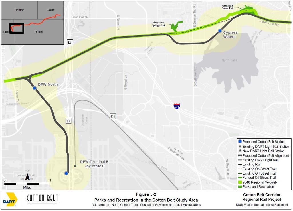
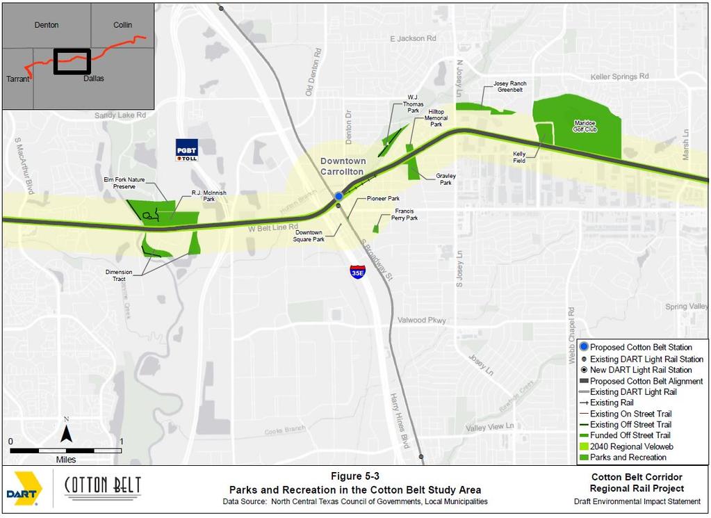
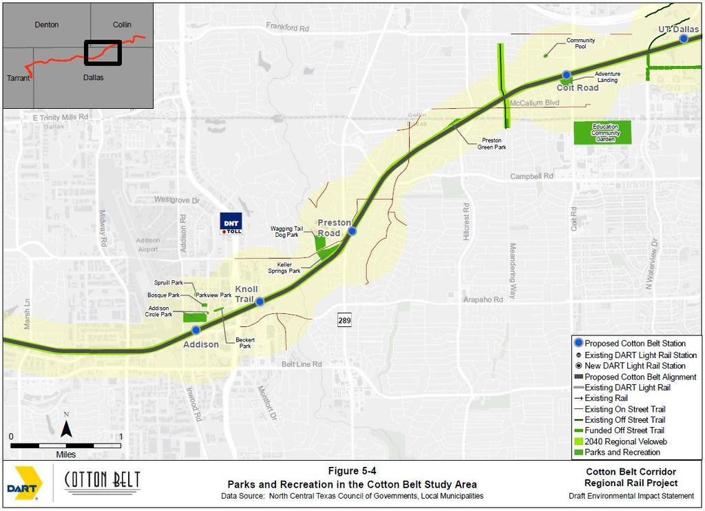
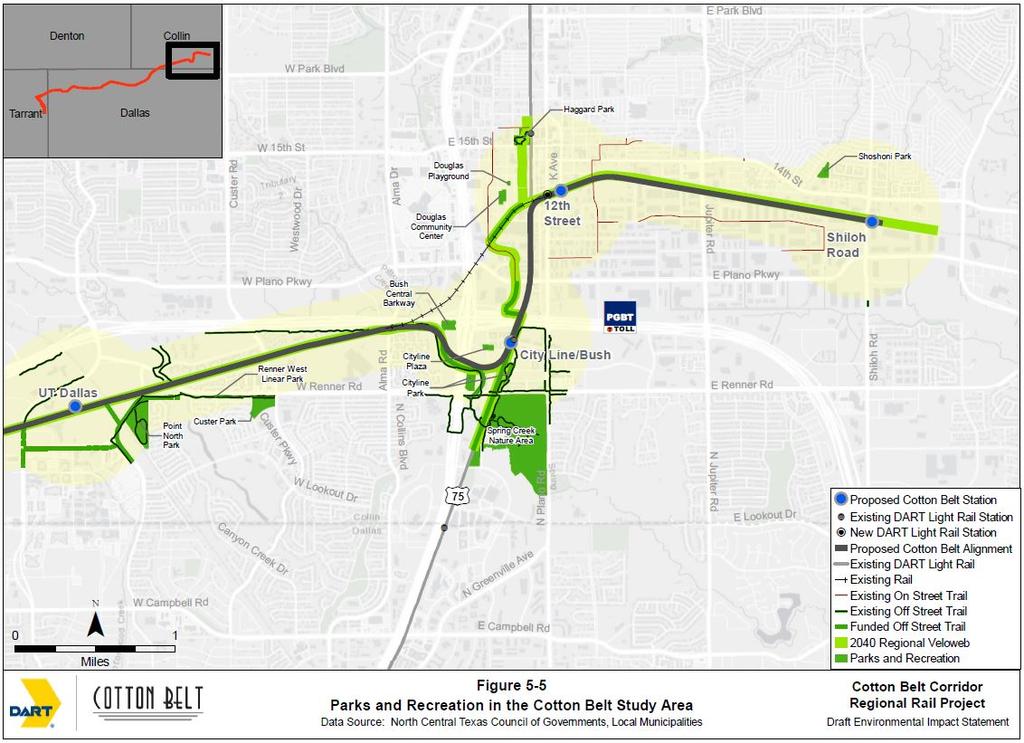
4 4.0 REGULATORY CONTEXT Although the Cotton Belt Project is not a federally funded project at this time, data collection and analysis efforts were in accordance with the National Environmental Policy Act (NEPA) standards. NEPA guidelines require that adverse effects on environmental resources from a proposed federally funded project be identified and avoided or minimized, including potential impacts to the human environment and social interactions. In accordance with Section 4(f) of the United States Department of Transportation (USDOT) Act of 1966, as amended (49 USC 303), requires that use of publicly-owned parks and recreational facilities be avoided when planning transportation projects, unless no other feasible or prudent alternatives exist. Section 6(f) of the Land and Water Conservation Fund (LWCF) Act states that parks developed or improved using LWCF grant monies cannot be acquired unless no other reasonable and feasible alternative exists and without coordination with the National Park Service (NPS). Chapter 26 of the Texas Parks and Wildlife Department (TPWD) Code states that a state agency, county, or municipality cannot approve a project that would require the use or taking of a public park or recreational land unless it is determined that no feasible or prudent alternative exists, adverse impacts have been minimized through the planning process, and a public hearing is held regarding the proposed use. DART policies require that the potential impacts of any proposed project (whether federally or locally funded) be assessed, and if adverse effects are found, that these impacts be avoided, or minimized and mitigated. As described in DART s Environmental Impact Assessment and Mitigation Guidelines for Transit Projects, project design and operating procedures must comply with all federal, state, county, and municipal statutory requirements and take into account advisory group safety recommendations. Security designs are also addressed in DART LRT Project Design Criteria Manual, Volume No. 1 (Infrastructure Design Criteria) (DART 2011). Pursuant to Executive Order 13045, Protection of Children from Environmental Health Risks and Safety Risks (EPA 2017), federal agencies are directed, as appropriate and consistent with the agency s mission, to make it a high priority to identify and assess environmental health risks and safety risks that may disproportionately affect children. 5.0 METHODOLOGY For the purposes of the Cotton Belt Project, the project study area this report has been determined to include a one-quarter mile buffer on either side of the proposed rail corridor and a one-half mile radius around each of the proposed station locations. Park and trail facilities were identified using the most current data from each city s website along with GIS data obtained from the North Central Texas Council of Governments (NCTCOG). The collected facility data was used as a baseline and compared with data gathered during field reconnaissance and aerial photography reviews. The Cotton Belt Project study area is shown in Figure 5-1. The project study area alignment begins at a point near DFW Airport in Grapevine, extends through Coppell, Carrollton, Addison, Dallas, Richardson, and terminates near Shiloh Road in Plano, just east of US 75. The Cotton Belt Study Area, which is defined as one-quarter mile on either side of the proposed corridor and one-half mile radius around each of the proposed station locations. The Cotton Belt Corridor pre-dates all listed facilities in the project study area. The most recent data from each city s

5 website and GIS data obtained from the North Central Texas Council of Governments (NCTCOG) was used as a basis for the inventory of existing park and recreational trails and supplemented with data gathered during field reconnaissance and a review of aerial photography. 5.1 Parks and Recreational Facilities The information provided in the following sections identifies parks, recreational facilities, and trails located within the defined study area. Facilities determined as 6(f) facilities as well as any historic sites known to date that would be protected under Section 4(f) of the USDOT Act of 1966, as amended are identified. The NCTCOG defines park and recreational facilities land use as Dedicated Parks which might include public and private parks, golf courses, cemeteries, public and private tennis courts and swimming pools, and amusement parks. Figures 5-2 to 5-5 shows the location of each inventoried facility along the Cotton Belt Corridor study area.
6
7
8
9
10 5.2 Publicly Owned Parks and Recreational Facilities This section describes public parks and recreational facilities that are found within the defined study area of the Cotton Belt Corridor. Table 5-1 provides a list of publicly owned parks, trails, and recreational facilities within the Cotton Belt Project study area. Table 5-1 Publicly Owned Parks and Recreational Facilities Inventory Facility Name Address City Grapevine Creek Park Grapevine Springs Park Preserve and A. W. Perry Homestead Museum Coppell 600 South Moore Road Coppell 700 South Park Road Coppell Carrollton Proximity to Station or Description Included on Regional Veloweb City/County Park 1509 North Perry Road Carrollton Dimension Tract 1199 Elm Park Drive Carrollton Downtown City Square Park and Gazebo Elm Fork Nature Preserve Elm Fork Nature Preserve 1103 west 3 rd (Main and Broadway) Carrollton 2335 Sandy Lake Road Carrollton No City/County Park 2335 Sandy Lake Road Carrollton Yes Francis Perry Park 1400 Francis and Ross Carrollton Station Gravley Park 1508 North Perry Road Carrollton - Gravley Park Loop 1508 North Perry Road Carrollton No Hutton Branch Purple Josey Ranch Lake Park Steenson Park to Kelly Boulevard Greenbelt is East of North Josey Lane; Surrounds Josey Park Estates Carrollton No Carrollton Park/ No Kelly Athletic Field 2000 Kelly Boulevard Carrollton Pioneer Park 1001 West Main Street (Carroll and Main Street) Carrollton R. E. Good Sports Complex 2335 Sandy Lake Road Carrollton
11 Table 5-1 Publicly Owned Parks and Recreational Facilities Inventory Facility Name Address City Proximity to Station or Description Included on Regional Veloweb McInnish Sports Complex and 2340 Sandy Lake Road Carrollton Park / - W. J. Thomas Sports Fields, and Splash Park 1955 North Perry Road Carrollton Addison Addison Circle Park 4950 Addison Circle Drive Addison Beckert Park 5044 Addison Circle Drive Addison Bosque Park Quorum Drive Addison Parkview Park 5032 Parkview Addison Spruill Park 4936 Marcus Avenue Addison City of Dallas Public Use Area Dallas, Station Davenport Road Dallas Keller Springs Park 5710 Keller Springs Road Dallas Public Use Area Preston Green Park 6900 Duffield Court Dallas Preston Ridge Wagging Tail Dog Park Bush Central Barkway Dog Park Begins at Haymeadow Drive and Coit Road Northward to Beltline Road; Parallel to Meandering Way to Mullrany Drive Just South of McCallum Boulevard 5841 Keller Springs Road Dallas 3581 North Central Expressway Dallas No Richardson Richardson Cityline Plaza 3451 Routh Creek Parkway Richardson Cityline Park 3451 Routh Creek Parkway Richardson Custer Park and Southwest corner of Custer Road and Renner Road Richardson Park/ No -
12 Table 5-1 Publicly Owned Parks and Recreational Facilities Inventory Facility Name Address City Point North Park and Renner West Linear Park Spring Creek Nature Area Spring Creek Nature University of Texas At Dallas (UTD) Douglass Community Center and Playground - Boys and Girls Club of Collin County Haggard Park and 3222 North Floyd Road Richardson Renner Road from Renner Road at Point North Parkway to Central Expressway Between Routh Creek Parkway and North Plano Road; South of East Renner Road From East Renner Road (Near Central Expressway) to Routh Creek Parkway Follows the property boundary of UTD; connects with Renner on Renner Road Proximity to Station or Description Park/ Included on Regional Veloweb Richardson No Richardson Richardson Richardson Plano 1111 Avenue H Plano 901 East 15 th Street Plano No Park/ - City/County No No Park Yes Shoshoni Park 1501 Del Sol Drive Plano Coppell Grapevine Springs Park Preserve and - This is a 23-acre park and designated historic site that abuts the Cotton Belt Corridor just west of Denton Tap Road. It is named for the aquatic springs that flow into a rock lined channel. Many of the rock features of this park were built with the funding from the Work Projects Administration (WPA) a part of the American New Deal Agency programs in The springs flow to the Elm Fork of the Trinity River. This park includes picnic facilities and trails. Grapevine Creek This City of Coppell Park includes 33.1 acres of undeveloped parkland. Carrollton A.W. Perry Homestead Museum - A museum that provides a look of early 20 th century life, the A.W. Perry Homestead Museum includes structures and land that were donated to the City of Carrollton in
13 1975. Today the 10-acre park is open to the public and conducts tours, holds a variety of events and can be rented for birthday celebrations, weddings, photography and other special occasions. It was designated a historic landmark in 1977 by the Texas Historical Commission. Dimension Tract The Park contains 38 acres of undeveloped land that is situated along the Elm Fork of the Trinity River. In addition to the 11.5 acres of native vegetative land parcels, the park has a 14-acre open water pond, 3.5 acres of wetland habitat, and 9 acres of bottom land hardwoods. There is paved parking available as well as benches and canoe and kayak launches into the Trinity River. Downtown City Square Park and Gazebo - This Park is a recognized historical site in Carrollton and is often rented for events. Elm Fork Nature Preserve - This 40-acre site was originally purchased as a wood right in 1861, but was never clear cut. The site was donated to the City of Carrollton in The site is a virtually undisturbed area and considered to be a valued example of a self-contained ecosystem. It is a designated nature area and includes an interpretive center, trails, and a Texas Wildscape. The City of Carrollton owns acres of the park, while Dallas County owns the other acres. A master plan is available for this site. The Preserve is located east of McInnish Park. Elm Fork Nature Preserve - This 0.78-mile, natural-surface trail is located inside the Elm Fork Nature Preserve. The trails are open 365 days a years from dawn until dusk. Francis Perry Park Located among large shade trees, this three-acre park in Carrollton includes picnic tables, grills, a lighted tennis court, and a newly replaced playground (2016). Gravley Park The 13-acre park site was dedicated to the city and is adjacent to the A.W. Perry Homestead Museum which includes walking paths, benches, a water fountain, and a parking lot. Gravley Park Loop - This one-quarter mile concrete path is located within Gravley Park, adjacent to the A.W. Perry Homestead Museum. Hutton Branch Purple This trail is on 15 acres just east of Carrollton City Hall. Situated along a park, this trail features concrete sidewalks and a wide walking trail from Steenson Park to Kelly Boulevard Josey Ranch Lake This 100-acre linear greenbelt connects several parks in the area, including Thomas Park, Jimmy Porter Park, Keller Springs Park, and Mill Valley Park. It is located adjacent to the BNSF rail corridor, and a portion of the park is within one-quarter mile of the Cotton Belt Corridor. Development of the park includes a 3.50 acre lake with fishing pier, concession/restroom facilities, natural area for observing birds and wildlife, hike and bike trails, picnic facilities, playground, and parking facilities. With an exception of an 18-hole disc golf course, 50 acres will remain undeveloped for a portion of the park that is located east of Josey Lane. Kelly Athletic Field This is a Carrollton-Farmers Branch Independent School District facility utilized by the public who are within the school district. It includes a baseball field, soccer fields, and locker rooms.
14 Pioneer Park Pioneer Park is only a 0.5 acre common area located near Old Downtown Carrollton. The park includes the city square and a gazebo. It has been designated a historical site. R.E. Good Sports Complex - This complex is located on a 48-acre site and is found within the McInnish Park Sports Complex site. Park amenities include five soccer fields, picnic tables, a playground, a nature trail, an overlook shelter, and drinking fountains. The complex can be accessed through McInnish Park via McInnish Park Drive. McInnish Park Sports Complex and - This 220-acre site accommodates both a park and a sports complex. The sports complex encompasses 186 acres on the south side of Sandy Lake Road and has 27 sports fields for baseball, softball, and soccer. The amenities include six concession stands/restrooms, two playgrounds, a lake for fishing and RC boats. The park provides picnic tables, grills and walking paths. The remaining 34 acres are leased by the city and are located on the north side of Sandy Lake Road. Within the 34-acre park are grills and picnic tables, a multipurpose sports field, and river frontage with a boat ramp. R.J. McInnish Park s are located in various areas within the Sports Complex. W. J. Thomas Sports Fields and Splash This 25-acre park includes lighted sports fields. It is located east of Josey Ranch Sports Complex and across Perry Road from the W.J. Thomas Splash Park (1955 North Perry Road). It also includes restrooms, concession stands, a playground, three tennis courts, and picnic facilities. It is located adjacent to the Burlington Northern Santa Fe (BNSF) rail corridor and within one-quarter mile of the Cotton Belt Corridor. Addison Addison Circle This ten-acre area is the site of Addison s many annual special events such as Addison s Taste Addison, Kaboom Town, and Oktoberfest. Park amenities include a pavilion, restrooms, benches, interactive fountains, two stages, pergola, park benches, and off-street parking. Beckert This park, formerly known as Esplanade Park, is now named after former mayor Rich Beckert. The park is nestled between the high-rise buildings of the Addison Circle District. The park features a lighted walkway, park benches, and on-street parking. Special musical events are held here June through August. Bosque This is a one-acre park which features dense tree cover (Red Cedar), a fountain, lighted walking path, patio tables, park benches and on-street parking. Parkview Park Parkview is a small 0.75 acre site located in the Addison Circle District and includes a pavilion, tables, a rose garden, and on-street parking. Spruill Park This 1.5 acre park is located within the Fairfield Development park and features a rose garden, a pavilion with seating area, a plaza with bench seating, and a large open lawn area Dallas City of Dallas Public Use Area This is a 2.5-acre wooded area open to the public. Keller Springs Park Keller Springs is a 10-acre park located south of the Wagging Tail Dog Park. White Rock Creek flows through this community park.
15 Preston Green Park This 4.4-acre is located south of McCallum Boulevard and west of Hillcrest Road. This neighborhood park includes park benches outdoor basketball courts picnic tables and a playground. A perennial stream, Floyd Branch, a tributary to Cottonwood Creek, flows through this community park. Preston Ridge This 6.25 mile trail begins at Haymeadow Drive and Coit Road. The trail follows an electric transmission line northward to Beltline Road and the west to Meandering Way. The trail then turns northward and follows Meandering Way to McCallum Boulevard. The trail makes a side loop at Salado Park near Bowie Elementary School. Another portion of this trail turns wet just past Arbor Oaks Drive crossing Hillcrest Road and Meadowcreek Drive, passing behind Brentfield Elementary School. Existing portions of the trail are within one-half mile of the proposed Renner Village Station as well as within one-quarter mile of the alignment as it crosses Davenport Road south of Campbell Road. Wagging Tail Dog This 6.9-acre dog park is located northwest of Preston Road. The park features walking trails, a fenced area for off-leash play, benches, dog and human drinking fountains, and an observation deck overlooking White Rock Creek. Richardson Bush Central Barkway Dog Park This six-acre park was made possible through a coordinated effort by Oncor and TxDOT provided the City of Richardson use of the space to locate this facility. The park includes separate areas for large and small dogs; the park has a central plaza with restrooms, shade structures and open space with different textures that include grass, decomposed granite, stone and logs. Central - The existing portion of this trail generally follows the Red Line LRT corridor from Arapaho Station to Renner Road. CityLine Park This is a 5.75-acre park facility at northwest corner of Renner Road and Routh Creek Parkway. The Central provides a connection to the DART station. The park provides pavilions, park benches, and trails for both hiking and biking. CityLine Plaza A centrally located urban plaza surrounded by restaurants, residential apartments and businesses. Custer Park and - This seven-acre park offers a softball field, a field area for soccer or lacrosse, a playground, two lighted tennis courts, picnic tables and on-site parking lot. Point North Park and - This is a Richardson City Park that features a large field area for soccer or lacrosse, a softball field, a playground, and a parking lot for park users. Renner West Linear The existing portion of this trail extends east from the intersection of Renner Road and Point North Parkway to Central Expressway. Spring Creek Nature Area - This City of Richardson recreational facility includes a 3.84-mile multi-use trail that extends from Renner Road and US 75 south and east through wooded areas and continues to connect with the Galatyn Woodland Preserve. The trail head at Renner Road and Central Expressway includes a parking lot and restrooms.
16 Spring Creek Nature - This City of Richardson trail connects to the bikeway on Alma Road and then heads south to the Spring Creek Nature Area. This existing trail winds through the nature area and terminates at Renner Road, where it will connect with the future extension of the Renner. University of Texas at Dallas (UTD) - This trail, which includes existing and future elements, follows the property boundary of UTD and connects with Renner on Renner Road. Plano Douglass Community Center and Playground - Boys and Girls Club of Collin County The Douglass Center houses the Collin County Boys and Girls Club. Programs are provided for children There is also a neighborhood playground adjacent to the Douglass Community Center in the courtyard by Thomas Gymnasium. Haggard Park and - This City of Plano park is adjacent to the Downtown Plano Red Line LRT station and includes a gazebo, playground, and restrooms. The Interurban Railway Museum is also located here. Shoshoni This City of Plano Neighborhood Park is located northwest of the proposed Shiloh Station area and includes a playground, grills, a water fountain, and an open sports practice field. 5.3 Privately Owned Facilities This section describes privately owned facilities that are found within one-quarter mile of the Cotton Belt Corridor and one-half mile of the proposed station locations. Table 5-2 provides a list of privately owned recreational facilities which are also located within the project study area. The Cotton Belt Corridor pre-dates all listed facilities in the project study area. Table 5-2 Privately Owned Recreational Facilities Facility Name Address City Proximity to Station or Coppell Future Carter Phase III 1 Legacy Court Coppell, Addition common area Station Open to Public or Private Homeowners Association (HOA) Common Area Riverchase Golf Club 700 Riverchase Drive Coppell Open to Public Yucatan Beach Club 1850 East Belt Line Road Coppell Open to Public Bahama Beach Club 1849 East Belt Line Road Coppell Open to Public Carrollton Dallas Pistol Club 1830 West Belt Line Road Carrollton Members Only Honors Golf Club (Maridoe Golf Club) 2525 Country Club Drive Carrollton Members Only The Country Place 2727 Country Place Drive Carrollton HOA Common Area Dallas The Clubs of Prestonwood Preston Road Dallas Open to Public
17 Table 5-2 Privately Owned Recreational Facilities Facility Name Address City Preston s HOA 5950 and 5955 Westgrove Circle, 9009 and Preston Drive, Ashbourne Drive Dallas Proximity to Station or Fairhill School Preston Road Dallas Adventure Landing Coit Road Dallas Somerset Amenity Center Maribeth Drive Dallas Richardson Education Community North Coit Road Richardson Garden at Texas AgriLife Extension Center The Practice Tee Golf 3570 Waterview Parkway Richardson Center Open to Public or Private Residential Common Areas Green Space Associated with Private School Open to Public HOA Common Area Open to Public Open to Public Canyon Creek Country Club 625 West Lookout Drive Richardson Open to Public Coppell Future Carter Phase III Addition common area (Platted) - This neighborhood common area in the Carter Phase III Addition will be privately owned by the HOA. Riverchase Golf Club - This is a privately owned golf course that offers both membership and daily-fee options. This club is within one-quarter mile of the Cotton Belt alignment. Yucatan Beach Club - This privately owned facility offers ten sand volleyball courts, a swimming pool, dart boards, and pool tables. Weekly leagues in sand volleyball, darts, and pool are offered here. Poker tournaments are also held at this site. A paved parking lot adjacent to the building is shared with abutting light industrial/warehouse businesses. The Cotton Belt Corridor crosses the only entrance to this business. The entrance from Belt Line Road to this facility is a shared entrance with a cement plant and the aforementioned abutting businesses. Access to the facility is granted through a license agreement with DART. Bahama Beach Club - This privately owned facility offers approximately eight sand volleyball courts and holds weekly leagues and tournaments. Carrollton Dallas Pistol Club - This private, members-only club is an outdoor shooting facility in Carrollton. Facilities include shooting ranges, bays for action pistol events, and an indoor airgun range. The only entrance to this facility crosses the existing Cotton Belt Corridor from Belt Line Road. Access to the facility is granted through a license agreement with DART.
18 Honors Golf Club Dallas - According to the club s website, this club was originally founded in 1881 as The Phoenix Club and then moved to Carrollton in the 1950s, when the organization built a golf course and country club. The club has also been known as the Columbian Club. The grounds include the largest privately-owned lake in Dallas County. The private, members-only facility offers one 18-hole golf course. This club is within one-quarter mile of the Cotton Belt Corridor. The only entrance to this golf club crosses the existing Cotton Belt alignment from Country Club Drive. Access to the facility is granted through a license agreement with DART. The Country Place - This area provides recreational facilities for its community of 742 homes. Facilities include tennis courts, swimming pools and lakes and ponds. Dallas The Clubs of Prestonwood - This is a privately owned club that is open to the public. It offers two 18- hole golf courses and is located within one-half mile of the proposed Knoll Station. Preston s HOA common areas - These privately-owned areas provide greenspace for the residents of the Preston s neighborhood. Fairhill School - This vacant 2.3-acre area along the bank of the McKamy Branch is owned by the private school. Adventure Landing - This privately owned facility offers family entertainment with an 18-hole miniature golf course, a go-kart speedway, batting cages, and arcade games. Somerset Amenity Center - This privately owned facility offers a swimming pool, play lot, picnic shelter, and basketball court. Richardson Education Community Garden at Texas AgriLife Extension Center The Texas A&M AgriLife Extension Service is available to every resident in every Texas county. The Practice Tee Golf Center - This golf facility in Richardson offers a nine-hole Par 3 short-game course, full driving range, and golf instruction. Its southern and southwestern property boundaries are adjacent to the Cotton Belt Corridor and a Kansas City Southern (KCS) rail line crosses over Cotton Belt Corridor in this area. Canyon Creek Country Club - This privately owned facility is open to the public and offers one 18-hole course. The club is within one-half mile of the proposed UTD/Synergy Park Station. 5.4 Future Recommended s The Cotton Belt project provides the surrounding area with numerous opportunities develop a contiguous system of interconnecting trails. This section describes the planned trail facilities that are found within one-quarter mile of the Cotton Belt Corridor and one-half mile of the proposed station locations. Table 5-3 provides a list of recommended trails proposed for construction.
19 Table 5-3 Future Recommended Facilities Inventory Facility Name Address City Location to Station or Description Regional Veloweb Future Cotton Belt Campion North MacArthur Boulevard Extension Future bike and pedestrian trail (Crosby ) Parallel to existing Cotton Belt Corridor for entire length of project (exact location unknown at this time) All Coppell From south of Mockingbird Lane at Irving s Proposed Campion Coppell, extending in a loop around North Lake. Carrollton Along Crosby Road from Josey Lane to the Green Line, then heading north generally paralleling the Green Line alignment Carrollton Future segments of existing regional trail Proposed Yes Yes Yes Funded bike and pedestrian trail (Hutton Branch ) Heading northeast along the Burlington Northern Santa Fe (BNSF) rail corridor generally from the intersection of the Green Line and proposed Cotton Belt alignments to Josey Lane Carrollton City/ County Yes Future bike and pedestrian trail (Elm Fork ) Preston Ridge Expansion Central Along the Elm Fork of the Trinity River Dallas From Mullrany Drive to North of Frankford Road; Parallel to Dallas Meandering Way Richardson From Renner Road to President George Bush Turnpike Dallas Yes Yes Richardson No
20 Table 5-3 Future Recommended Facilities Inventory Facility Name Address City Renner West Linear Park and Red Line Light Rail Transit (LRT) corridor east to North Plano Road Location to Station or Description Regional Veloweb Richardson No Spring Creek UTD Winds through Richardson connecting to Renner Follows through UTD property connecting to Renner Richardson No Richardson No Plano 15th Street Station Along Avenue I From Haggard Park to Near 18 th Street Plano Yes Plano Central Link From 12 th Street to 18 th Street through Haggard Park Plano Yes Regional Veloweb - As part of the NCTCOG Mobility 2040 Plan (Mobility 2040 Plan), the Regional Veloweb (Veloweb) has been expanded to 1,876 miles. The Veloweb is a part of the long-term metropolitan transportation plan adopted by the Regional Transportation Council (RTC), the transportation policy body of the Metropolitan Planning Organization for the Dallas-Fort Worth area. As a planned network of off-street shared-use paths (trails), the Veloweb is designed to serve as a means for bicyclists, pedestrians, and other non-motorized forms of transportation to move about the local areas. Additionally, the Veloweb functions as the regional network for users providing alternatives to the region s roadway and passenger rail transit network. Veloweb alignments are developed through cooperative efforts of local community governments and NCTCOG staff and presently represent 56 local plans with shared-use paths (trails) and an additional 23 local plans that include on-street bikeway facilities. Veloweb connections are planned in 10 counties and 105 cities in North Central Texas region. Cotton Belt (Future) This planned trail stretches from Fort Worth to Wylie within the existing DART-owned Cotton Belt right-of-way (Cotton Belt Corridor). DART does have a Hike and Bike Use policy (Resolution # ) that allows for implementation of trails within DART-owned right-of-way. DART would retain ownership and transit purposes would supersede trail uses. Cities and counties within the region are responsible for the planning and implementation of bicycle and pedestrian infrastructure and amenities. Community Pathways are similar to the Veloweb, and although they may not provide a connection to a major destination, they help supplement the Veloweb network. Coppell Campion North MacArthur Boulevard Extension This planned trail would extend south from Belt Line Road near Mockingbird Lane and Irving s proposed Campion around North Lake.
21 According to Making Connections Reality... Community-Wide s Implementation Plan (Coppell, 2010), the trail around this scenic area should include a 12-foot wide concrete trail which would connect land uses on this large tract of land, and also to the regional Veloweb. Carrollton Crosby This trail would be an extension of the Hutton Branch, which is a 3.4 mile concrete shared used path connects residents with parks and the city s DART train station. The city plans to eventually extend the trail south along the DART Green Line to Crosby Road (link, 2017). Dallas Elm Fork The Elm Fork as proposed will be follow along Elm Fork Creek from the Trinity Meanders near I-35E to just south of Bachman Lake. Preston Ridge Expansion An extension of this trail will continue north from McCallum Boulevard to State Highway (SH) 190. Supporters of this trail have formed a group called the Friends of Preston Ridge. The organization maintains a website to share trail information, news, and donation opportunities. Richardson Central - The future portion of the trail will extend north from Renner Road to just north of President George Bush Turnpike. Renner West Linear A future extension of this trail is planned from the Red Line Light Rail Transit (LRT) corridor east to North Plano Road to connect with existing walkways on Renner Road east of North Plano Road. Spring Creek - The existing trail winds through the Spring Creek Nature Area and terminates at Renner Road. The proposed expansion will allow it to connect with the future extension of the Renner. University of Texas at Dallas (UTD) The existing trail will connect to proposed trails planned to follow the property boundary of UTD and also with Renner on Renner Road. Plano 15 th Street Station Proposed along Avenue I from Haggard Park to 18 th St. Plano Central Link Proposed trail along Avenue A through Haggard Park from 12 th to 18 th Street. 5.5 Section 4(f) and Section 6(f) Properties All publicly owned facilities listed above are potential Section 4(f) properties that would likely be protected by Section 4(f) regulations. In addition, historic resources, whether privately owned or publically owned, also fall under the protection of Section 4(f). Listed on or eligible for listing on the National Register of Historic Places (NRHP) are potential Section 4(f) properties, as well properties with local historical significance even if not NRHP-listed or eligible. Potential Section 4(f) Properties
22 Publically owned parks or recreational facilities covered under Section 4(f) that may be affected by the proposed project are discussed in the Parks and Recreational Facilities Impact Assessment Technical Memorandum. Future stages of project development should consider alternatives or methods to avoid use of Section 4(f) properties. Park facilities within the project area that are identified as known historic resources include the A.W. Perry Homestead Museum, the Downtown City Square Park and Gazebo, and Pioneer Park. Historic resources within a defined area of potential effect (APE) are discussed in the Cultural Resources Existing Conditions Technical Memorandum, the Archeological Resource Survey (2017), the Historic Resources Reconnaissance Survey Report (2013) and the Historic-age Resource Reconnaissance Survey (2017). Archeological Resources Only new rail, station, and support facility ROW were subject to intensive survey efforts as existing rail ROW areas were determined to be previously disturbed and not likely to impact undocumented archeological sites. Two newly documented archeological sites were discovered during field investigations. Site 41COL291 is a railroad section foreman house within the proposed Plano 12th Street Station footprint. This site is recommended as ineligible for listing in the NRHP within the current APE. Site 41DL535 is a historic-age farmstead site located on the east side of Grapevine Creek. A new bridge is planned to be constructed as a part of this proposed project. This site is recommended as eligible for listing in the National Register of Historic Places (NRHP) with further detailed testing recommended prior to construction of the Plano Station. Historical Resources Previous 2013 efforts documented 68 historic-age resources along the proposed Cotton Belt Corridor Regional Rail project. The 2017 survey documented six new historic-age resource sites. However, based on avoidance practices implemented in the design, a determination has been made that the proposed actions would have no adverse effect to historic properties. Potential Section 6(f) Properties Four Section 6(f) resources were identified in the project study area. Four LWCF grants were found in the NPS LWCF grant database for the project study area. All four entries are located in Dallas County. One recreational facility, McInnish Park in Carrollton, has had three grants awarded since the 1970s for some portions of its complex. The other park receiving LWCF funding is also located in Carrollton: Thomas Park. The grant database entries themselves do not provide specific details regarding the work that was funded by the grant; however, the title of the grant sometimes offers a clue. Generally, grants under Section 6(f) stipulate that the entire park will be considered as covered under the conversion restriction even though a grant may have been for only a small part of a park. In rare cases the grant may specify that only a part of the park is covered.
23 6.0 SOURCE INFORMATION AND REFERENCES Addison, Parks at a Glance. Accessed online Carrollton, Parks. Accessed online Park and Sports Complex CityLine, Outside the Line. Accessed online Coppell, Making Connections Reality... Community-Wide s Implementation Plan. Accessed online Recreation/coppelltrailsimplementationmp.pdf August 14, Coppell, Parks, Pavilions, & s. Accessed online Dallas, Dallas Parks & Recreation. Accessed online Plano, Parks and Recreation. Accessed online ing, Hutton Branch Description. Accessed online August 23, 2017
REQUEST FOR SHPO CONSULTATION: Projects Subject to Section 106 of the National Historic Preservation Act and/or the Antiquities Code of Texas
 REQUEST FOR SHPO CONSULTATION: Projects Subject to Section 106 of the National Historic Preservation Act and/or the Antiquities Code of Texas Submission of this form only initiates consultation with the
Cotton Belt Regional Rail Corridor Project
 Cotton Belt Regional Rail Corridor Project North Dallas AFG University of Texas at Dallas Administration Building March 1, 2018 0 Discussion Public Involvement Project Scope Alignment Stations Environmental
Cotton Belt Corridor Regional Rail
 Cotton Belt Corridor Regional Rail Visual Impact Assessment Technical Memorandum December 2013 Prepared for Dallas Area Rapid Transit General Planning Consultant Managed by URS Corporation Cotton Belt
Honorable Members of the Mobility Solutions, Infrastructure and Sustainability Committee
 Memorandum DATE March 23, 2018 CITY OF DALLAS TO Honorable Members of the Mobility Solutions, Infrastructure and Sustainability Committee SUBJECT Cotton Belt Regional Rail Corridor Project On Monday, March
Elm Fork Land Use. Trinity River Corridor Project Committee May 13, 2013
 Elm Fork Land Use Trinity River Corridor Project Committee May 13, 2013 Purpose Discuss Trinity River planned Land Use and Appropriate Compatible Uses, particularly with respect to the Elm Fork Area 2
City Council March 27, Parks, Recreation, and Trails Master Plan
 City Council March 27, 2018 Parks, Recreation, and Trails Master Plan Planning Process Develop Goals and Objectives Inventory of Areas and Facilities Needs Assessment And Identification Public Participation
PARKS & RECREATION SUBCOMMITTEE. Oct. 1, 2015
 PARKS & RECREATION SUBCOMMITTEE Oct. 1, 2015 1999 Bond - $22,000,000 Land Acquisition Allen Station Phase II Neighborhood Parks PREVIOUS BOND ELECTIONS 1999 & 2007 2002 Bond - $4,000,000 Allen Senior Recreation
Cotton Belt Corridor. Area Focus Group (AFG) Richardson/Plano August 24, John Hoppie, Capital Planning
 Richardson/Plano August 24, John Hoppie, Capital Planning") Cotton Belt Corridor Area Focus Group (AFG) Richardson/Plano August 24, 2017 John Hoppie, Capital Planning 0 Agenda Design Update Environmental Update Documentation of Existing Conditions Noise Traffic
Cotton Belt Corridor Area Focus Group (AFG) Richardson/Plano August 24, 2017 John Hoppie, Capital Planning 0 Agenda Design Update Environmental Update Documentation of Existing Conditions Noise Traffic
North Oakville East Parks Facilities Distribution Plan. November, 2009
 North Oakville East November, 2009 POLICY CONTEXT 1) Purpose a) The purpose of this document is to be a guide for the location, configuration, design and development of the parks system for the North Oakville
Northeast Quadrant Plan
 Northeast Quadrant Plan Northeast Quadrant Distinctive Features Land Use The Northeast Quadrant includes all the area within the planning area that is east of Interstate 5 and to the north of State Route
Cotton Belt Corridor Regional Rail; Land Use Existing Conditions Technical Memorandum. John Hoppie, Project Manager, DART Capital Planning
 MEMO Date: Tuesday, August 01, 2017 Project: To: From: Subject: Cotton Belt Corridor Regional Rail; Land Use Existing Conditions Technical Memorandum John Hoppie, Project Manager, DART Capital Planning
Appendix E Section 4(f) Evaluation
 Evaluation") Appendix E Section 4(f) Evaluation Appendix E Draft Section 4(f) Evaluation E.1 Introduction This appendix addresses a federal regulation known as Section 4(f), which protects parks, recreation areas,
Appendix E Section 4(f) Evaluation Appendix E Draft Section 4(f) Evaluation E.1 Introduction This appendix addresses a federal regulation known as Section 4(f), which protects parks, recreation areas,
Chapter 6. Overall Vision RECOMMENDATIONS. More Trail and Trail. Connections. Equal Access to Park. Facilities and Programs. Water Access.
 Overall Vision More Trail and Trail Connections Equal Access to Park Facilities and Programs Water Access Environment Variety Chapter 6 RECOMMENDATIONS Chapter 6 The following recommendations for park,
Southeast Quadrant Plan
 Southeast Quadrant Plan Southeast Quadrant Distinctive Features Land Use The Southeast Quadrant includes all the area within the planning area that is east of Interstate 5 and south of State Route 44.
PARTF Scoring System for Grants
 PARTF Scoring System for Grants The members of the N.C. Parks and Recreation Authority use the PARTF scoring system as one of several tools to select grant recipients. Please provide all of the information
Mendota Heights 2040 Comprehensive Plan Draft Vers
 4 Parks and Trails The City of Mendota Heights boasts a variety of recreational and open space opportunities. Few cities can claim access to regional trails, riverside and lakeside parks, scenic bluffs
Cotton Belt Corridor Regional Rail
 Cotton Belt Corridor Regional Rail Land Use Existing Conditions Technical Memorandum December 2013 Prepared by URS Corporation Prepared for Dallas Area Rapid Transit General Planning Consultant Managed
Cotton Belt Corridor Regional Rail
 Cotton Belt Corridor Regional Rail Socioeconomic Impact Assessment Technical Memorandum December 2013 Prepared by URS Corporation Prepared for Dallas Area Rapid Transit General Planning Consultant Managed
Little Neck Planning Area
 Little Neck Planning Area Current Reality The Little Neck Planning Area is characterized by established residential neighborhoods, Town Center and Pembroke. The Eastern and Western Branches of the Lynnhaven
Appendix B. Technical Memoranda and Reports
 Cotton Belt Corridor Regional Rail Project Draft Environmental Impact Statement Appendix B Technical Memoranda and Reports Technical memoranda and reports were prepared as independent documents to support
Courthouse Planning Area
 Courthouse Planning Area Current Reality The Courthouse Planning Area is the characterized by expansive suburbanscale residential areas as well as the community resource planned area of athletic, educational,
Appendix A. Park Land Definitions
 Appendix A Park Land Definitions Mini Park May serve specific function for any and all ages, depending on need of the user area. Size range 1-5 acres with optimum size being 3 acres. Service area is sub-neighborhood
1. Parks & Recreation Neighborhood Parks Community Parks Special Use Sites 2. Open Space 3. Trails
 Appendix A: Park Classifications The intent of parks and recreation classifications is to aid in making acquisition and design decisions for park sites, facilities and the organization of recreation space
Emerson Park Master Plan Update. Public Meeting III August 27, 2014
 Emerson Park Master Plan Update Public Meeting III August 27, 2014 Meeting Agenda: Project Update Presentation of Master Plan Components Discussion and Feedback The Path Forward: Building on the Concept
Provide and maintain sufficient public parks, recreation facilities, and open space to meet the recreational needs of County residents and visitors.
 (ROS) Goal Provide and maintain sufficient public parks, recreation facilities, and open space to meet the recreational needs of County residents and visitors. OBJECTIVE ROS.01 The County shall acquire,
Open Space and Recreational Resources
 Chapter 3: Open Space and Recreational Resources A. INTRODUCTION Under the 2012 City Environmental Quality Review (CEQR) Technical Manual guidelines, open space is defined as publicly accessible, publicly
Outdoor Recreation Facilities Inventory
 Outdoor Recreation Facilities Inventory Allouez Neighborhood Parks: East Lawn Park (4.90 acres) is located in the northeastern corner of Allouez near Boyd Street. This site contains: Baseball diamond with
EL DORADO COUNTY GENERAL PLAN PARKS AND RECREATION ELEMENT PRINCIPLE INTRODUCTION STATE AUTHORIZATION
 EL DORADO COUNTY GENERAL PLAN PARKS AND RECREATION ELEMENT PRINCIPLE The General Plan must identify the types of governmental services, including parks and recreation facilities, which are necessary to
6 COMMUNITY SERVICES AND FACILITIES
 6 COMMUNITY SERVICES AND FACILITIES 6.1 PARKS AND OPEN SPACE The Hecker Pass Specific Plan provides over 98 acres of public parks and open space as shown in Figure 6-1. The bulk of this acreage is located
RECREATION AND OPEN SPACE ELEMENT
 RECREATION AND OPEN SPACE ELEMENT Last amended August 19, 2008 Table of Contents Objective Page 5.1 Park system defined... 5-1 5.2 Access to parks and recreational facilities... 5-2 5.3 Recreation and
The urban parks in Charlottesville include Jackson Park, Lee Park, and McGuffey Park.
 Park Classifications Charlottesville s parks can be grouped into 4 different classifications: urban parks, neighborhood parks, community parks, and regional parks. Figure 1 on page 5 inventories the facilities
4.1 AESTHETICS AND VISUAL QUALITY
 SCOPE AND METHODOLOGY 4.1 AESTHETICS AND VISUAL QUALITY This section evaluates the potential impacts to aesthetics and visual quality. Aesthetics refers to visual resources and the quality of what can
Great Neck Planning Area
 Great Neck Planning Area Current Reality The Great Neck Planning area is characterized primarily by large lot/lowdensity residential development with the majority of recreational opportunity existing as
APPENDIX D2: PARKS AND TRAILS
 APPENDIX D2: PARKS AND TRAILS Cultivate Hopkins Comprehensive Plan 8/15/18 DRAFT Cultivate Hopkins Appendix D2 1 Existing Conditions Local Parks and Trails Figure D2.1 shows the existing park and trail
Section 3 INVENTORY OF RECREATION LAND AND FACILITIES
 Photo of Juan Bautista de Anza Park Section 3 INVENTORY OF RECREATION LAND AND FACILITIES Summary of Findings Park Definitions Summary of Recreation Facilities Other Recreation Facilities Nearby Recreation
4.500 Preston Road Overlay District
 Section 4.500 Preston Road Overlay District 2004 Zoning Ordinance 4.500 Preston Road Overlay District (ZC 98-29; Ordinance No. 98-9-12) 4.501 Purpose To provide appropriate design standards for the use
Kempsville Planning Area
 Kempsville Planning Area Current Reality The Kempsville Planning Area is by far the most populated planning area in the City. The preservation of the 1,422 Stumpy Lake Natural Area, the largest City-owned
The Trinity River Corridor Project Update
 The Trinity River Corridor Project Update Councilmember Carolyn A. Davis Community Meeting October 14, 2008 The project covers 20 miles of the Trinity River, approx. 10,000 acres 2 Trinity River Corridor
6. RECREATION AND OPEN SPACE ELEMENT
 6. RECREATION AND OPEN SPACE Introduction This Recreation and Open Space Element includes Goals, Objectives and Policies (GOP) that apply to the main campus in Gainesville and the Lake Wauburg Recreation
The only significant recreation deficiency in Conway is the absence of an integrated greenway and multipurpose trail system.
 CHAPTER 6 RECREATION 1. Introduction This recreation chapter is prepared in compliance with recently revised state statutes dealing with the completion of municipal master plans [RSA 674:2 III (F)]. This
Chapter 5: Recreation
 Chapter 5: Recreation Introduction and Setting Recreational opportunities within Nevada County are varied, ranging from public parks with intensively used active recreational facilities, to vast tracts
Notice of Preparation (NOP) of an Environmental Impact Report and Public Scoping Meeting for the Alameda Shipways Residential Project
 of an Environmental Impact Report and Public Scoping Meeting for the Alameda Shipways Residential Project") Notice of Preparation (NOP) of an Environmental Impact Report and Public Scoping Meeting for the Notice is hereby given that the City of Alameda, Lead Agency, will prepare an Environmental Impact Report
Notice of Preparation (NOP) of an Environmental Impact Report and Public Scoping Meeting for the Notice is hereby given that the City of Alameda, Lead Agency, will prepare an Environmental Impact Report
master plan hodge park
 KCMO Parks & Commissioners Recreation Board of Parks & Recreation Kansas City, Missouri Mark McHenry Director Heather Runkel Project Manager LAND3 Studio L.L.C. Bob G Bushyhead Principle Michael H Malyn
Y Sports Complex PROGRAMMING Capitol Improvement Plan. Anticipated/Suggested Improvements. Sedgwick County Park: Sports Complex:
 PROJECT OVERVIEW Location: East of Ridge Road, between 21 st Street and 13 th Street, not including SCZ In conjunction with The Sedgwick County Park Facilities Observation Report Compilation of improvements
CY-FAIR ISD Exemplary-rated schools
 -ACRE master planned community GREEN SPACE within a quarter-mile of every home -SQ.FT. community center CY-FAIR ISD Exemplary-rated schools Located in Cypress, Texas, Bridgeland is northwest Houston s
Parks, and Recreation & Cultural Arts Master Plan Update
 Parks, and Recreation & Cultural Arts Master Plan Update Community Profile Public Input Summary: Staff Interviews conducted April 14 and 15, 2014 Citizens Workshop - conducted April 15 th and 24 th, May
Draft Environmental Assessment
 Draft Environmental Assessment CASCADE PARK Orem City, Utah A conversion of land protected under Section 6(f)(3) of the Land and Water Conservation Fund Act, Public Law 108-98 September 2017 For information,
UNIVERSITY OF MICHIGAN:
 Chapter Eight UNIVERSITY OF MICHIGAN: North Campus I. Introduction The University of Michigan currently owns approximately 800 acres of land in the northeast section of Ann Arbor. North Campus refers to
Draft Stillwater 2030 Comprehensive Plan- Goals and Policies
 Draft Stillwater 2030 Comprehensive Plan- Goals and Policies Instructions- Review each goal and policy and discuss with group any changes, deletions for additions to the list using your groups pen. Keep
To: Planning Commission D.. June 3, 2009
 Agenda Item No. 9(a~ CITY OF WOODINVILLE, WA REPORT TO THE PLANNING COMMIS ION 17301 133 1'd Avenue NE, Woodinville, WA 98072 WWW.CI.WOODINVILLE.WA.US To: Planning Commission D.. June 3, 2009 From: Subject:
Sustainable Development Call for Projects
 Sustainable Development Call for Projects 2005-2006 Infrastructure Project Examples *Note: This list is not all inclusive, but a sampling of the types of projects that were awarded funds. 137 Projects
KASPER. City of Georgetown, Texas PUD Planned Unit Development. December 30, 2015 Revised January 27, 2016
 KASPER City of Georgetown, Texas PUD Planned Unit Development December 30, 2015 Revised January 27, 2016 Applicant: Sentinel Land Company, LLC 4910 Campus Drive Newport Beach, CA Prepared by: SEC Planning
Chapter 5: Natural Resources and Environment
 NATURAL RESOURCES AND ENVIRONMENT 5-1 5 Chapter 5: Natural Resources and Environment BACKGROUND AND INTENT Urban expansion represents the greatest risk for the future degradation of existing natural areas,
Pinellas County Greenways
 Pinellas County Greenways USING GREENWAYS TO LINK OPEN SPACES The Florida Greenways Commission has defined a greenway as...a corridor of protected open space that is managed for conservation and/or recreation.
Memo Preliminary. City of Miamisburg Parks Site Reconnaissance
 Memo Preliminary To: From: Ms. Rebecca Benna Woolpert, Inc. Date: Subject: City of Miamisburg Parks Site Reconnaissance The consultant team toured the existing Miamisburg Parks to assess current levels
DISCUSSION TOPIC: ST JOHNS RIVER & ITS TRIBUTARIES (BPII) 2030 COMPREHENSIVE PLAN POLICES AND REGULATORY FRAMEWORK
 2030 COMPREHENSIVE PLAN POLICES AND REGULATORY FRAMEWORK") DISCUSSION TOPIC: ST JOHNS RIVER & ITS TRIBUTARIES (BPII) 2030 COMPREHENSIVE PLAN POLICES AND REGULATORY FRAMEWORK St. John s River & Its Tributaries Issue Summary: The St. Johns River is an important
DISCUSSION TOPIC: ST JOHNS RIVER & ITS TRIBUTARIES (BPII) 2030 COMPREHENSIVE PLAN POLICES AND REGULATORY FRAMEWORK St. John s River & Its Tributaries Issue Summary: The St. Johns River is an important
WEST OAK CLIFF RED LINE EXTENSION
 INITIAL ALTERNATIVES CORRIDOR EVALUATION WEST OAK CLIFF RED LINE EXTENSION Hampton C O R R I D O R I N F O R M AT I O N 408 303 Keist Keist Blvd Duncanville Rd 2 Red Bird Ln Executive Airport Boulder "
Mississippi Skyway Preliminary Engineering Report
 EXECUTIVE SUMMARY Mississippi Skyway Preliminary Engineering Report CITY OF RAMSEY, MINNESOTA DECEMBER 2014 City of RAMSEY EXECUTIVE SUMMARY Project Need and Intent The Mississippi Skyway pedestrian bridge
Exhibit A. SH 161 RTC Work Program of New Projects. Collin County
 Exhibit A SH 161 RTC Work Program of New Projects Collin County 0918-24-969 N/A 0918-24-970 N/A 0918-24-973 N/A 2351-01-020 N/A 2679-03-010 N/A On Exchange Parkway from US 75 to Allen Heights On Country
RECREATION AND OPEN SPACE VISION
 City of South Lake Tahoe General Plan Policy Document Recreation and Open Space Element INTRODUCTION This element provides the policy context for the City of South Lake Tahoe to achieve its vision for
Plano Tomorrow Joint Work Session
 Plano Tomorrow Joint Work Session City Council and Planning & Zoning Commission June 30, 2014 Strong Agreement More than 80% of respondents agreed with the statement. (9 of 16) Agreement Between 60% and
Northern Branch Corridor SDEIS March 2017
 Northern Branch Corridor SDEIS March 2017 15. 15.1. Chapter Overview 15.1.1. Introduction This chapter discusses changes to the Preferred Alternative resulting in the potential for project improvements
The following principles guide the development of goals and strategies to protect and promote these amenities:
 OPEN SPACE/PARKS/TRAILS/RECREATION GOALS/STRATEGIES Cherry Hills Village is a living environment that offers low density development, open areas, public scenic vistas, public trails and public parks. This
The transportation system in a community is an
 7 TRANSPORTATION The transportation system in a community is an important factor contributing to the quality of life of the residents. Without a sound transportation system to bring both goods and patrons
SECTION 4(f) DE MINIMIS DOCUMENTATION
 DE MINIMIS DOCUMENTATION") SECTION 4(f) DE MINIMIS DOCUMENTATION Illinois Route 60/83 IL 176 to the intersection of IL 60 (Townline Road) Lake County P-91-084-07 Mundelein Park and Recreation District Project Limit SECTION 4(f)
SECTION 4(f) DE MINIMIS DOCUMENTATION Illinois Route 60/83 IL 176 to the intersection of IL 60 (Townline Road) Lake County P-91-084-07 Mundelein Park and Recreation District Project Limit SECTION 4(f)
4 C OMMUNITY D ISTRICTS
 4 C OMMUNITY D ISTRICTS N ew development in the Area will include many different types of land uses, including a destination retail area that attracts people from all over the region; recreation opportunities
1.0 Introduction. Purpose and Basis for Updating the TMP. Introduction 1
 1.0 Introduction The Town of Castle Rock is situated between the metropolitan areas of Denver and Colorado Springs, amidst a unique terrain of rolling hills, mesas, ravines, and waterways. Like many Front
BURTON STATION STRATEGIC GROWTH AREA PLAN UPDATE PUBLIC MEETING 3/26/18
 BURTON STATION STRATEGIC GROWTH AREA PLAN UPDATE PUBLIC MEETING 3/26/18 1 WHERE WE ARE? 2 PRIMARY OBJECTIVES OF THE PLAN UPDATE 1. Update the land use designation for Burton Station Village to reflect
BeltLine Corridor Environmental Study
 BeltLine Corridor Environmental Study Joint TAC and SAC Meeting December 8, 2008 What We Will Discuss Today Outreach and Agency Coordination Scoping Results Existing Conditions Historical and Archeological
Park Types and Attributes
 02 APPENDIX B APPENDIX B s and s 194 APPENDIX B 04 Size Level of Service Any privately owned park, of any size, is a neighborhood park Primary Service Area - 1/2 mile or within 15 minutes walking distance
M-NCPPC Park System in
 Park Planning & Stewardship Division Park & Trail Planning Section East County Science Center Master Plan Parks, Recreation, Trails, and Open Space- Issues and Opportunities PARK PLANNING & STEWARDSHIP
RECREATION AND OPEN SPACE ELEMENT GOALS, OBJECTIVES, AND POLICIES
 RECREATION AND OPEN SPACE ELEMENT GOALS, OBJECTIVES, AND POLICIES Goal 7 To provide park facilities, recreation programs, and open space resources that are safe, adequate, and accessible to all City residents,
Town Center. Block 5 Existing multifamily residential units are expected to remain.
 Area Guidelines Germantown s districts should be developed as distinct communities with unique features that are supported through the guidelines. The guidelines not only help distinguish these districts
PARK & RECREATION. Project Summaries
 PARK & RECREATION Project Summaries 45 BEAVER ISLAND TRAIL EXTENSION - PHASE VIII - 60TH ST S TO CITY LIMITS Project Number: PK.19.01 Construction Year: 2019 quality services to area residents who utilize
ARROYO PROJECTS ADOPTED CAPITAL IMPROVEMENT PROGRAM BUDGET
 A RROYO P ROJECTS ADOPTED CAPITAL IMPROVEMENT PROGRAM BUDGET FISCAL YEARS 214-218 HAHAMONGNA Priority Description 1 Hahamongna Watershed Park - Implement Master Plan 211,6 211,6 (77565) 2 Hahamongna -
DRAFT SECTION 4(F) EVALUATION STILLWATER MUNICIPAL BARGE FACILITY
 EVALUATION STILLWATER MUNICIPAL BARGE FACILITY") DRAFT SECTION 4(F) EVALUATION I. DESCRIPTION OF SECTION 4(F) RESOURCE The Section 4(f) resource discussed in this evaluation is known as the Stillwater Municipal Barge Facility property, known previously
DRAFT SECTION 4(F) EVALUATION I. DESCRIPTION OF SECTION 4(F) RESOURCE The Section 4(f) resource discussed in this evaluation is known as the Stillwater Municipal Barge Facility property, known previously
DRAFT SECTION 4(f) EVALUATION INTERSTATE 73 FEIS: I-95 to I-73/I-74 in North Carolina
 EVALUATION INTERSTATE 73 FEIS: I-95 to I-73/I-74 in North Carolina") DRAFT SECTION 4(f) EVALUATION INTERSTATE 73 FEIS: I-95 to I-73/I-74 in North Carolina 1.0 INTRODUCTION Section 4(f) of the Department of Transportation Act of 1966, 49 U.S.C. 303, requires that prior to
DRAFT SECTION 4(f) EVALUATION INTERSTATE 73 FEIS: I-95 to I-73/I-74 in North Carolina 1.0 INTRODUCTION Section 4(f) of the Department of Transportation Act of 1966, 49 U.S.C. 303, requires that prior to
Lewisville Lake Master Plan Revision Public Information Meeting May 2 & 4, 2017
 Lewisville Lake Master Plan Revision Public Information Meeting May 2 & 4, 2017 Presented By Rob Jordan Lake Manager U.S. Army Corps of Engineers Fort Worth District US Army Corps of Engineers Purpose
Throughout. square. (Crystal City Vision Plan 2050)
") 1: Terms related to the PSMP document 1 public space (see also public realm, civic space) An open space designated on the regulating plan, accessible to all, including Plazas, Mini Parks, and Neighborhoods
1: Terms related to the PSMP document 1 public space (see also public realm, civic space) An open space designated on the regulating plan, accessible to all, including Plazas, Mini Parks, and Neighborhoods
MCCOYS CREEK RESTORATION 30% DESIGN
 MCCOYS CREEK RESTORATION 30% DESIGN THE MCCOYS CREEK RESTORATION PLAN The restoration plan aims to reduce flooding, restore ecosystem health, expand recreational opportunities along the creek, and connect
Neighborhood Districts
 NEIGHBORHOOD DISTRICTS SEVEN MAIN DISTRICTS Neighborhood Districts While the Development Plan provides a broad-scale overview of the neighborhood, this section focuses on uses and relationships at the
Appendix 4 Park, Trail, and Recreation Facilities For more information, call the Park Planning and Stewardship Division at
 Appendix 4 Park, Trail, and Recreation Facilities For more information, call the Park Planning and Stewardship Division at 301-650-4380 montgomery county planning board maryland-national capital park and
City of Naples Parks Master Plan (Draft)
") City of Naples (Draft) CSAB April 12, 2016 OVERVIEW Presentation Outline Overview Needs Assessment Recap Response to Needs Implementation Strategy Questions, Discussion Preserving Naples: A vision plan
City of Naples (Draft) CSAB April 12, 2016 OVERVIEW Presentation Outline Overview Needs Assessment Recap Response to Needs Implementation Strategy Questions, Discussion Preserving Naples: A vision plan
CHAPTER 1. Ms. Guajardo s Class - Central Elementary CH 1 1
 INTRODUCTION CHAPTER 1 Ms. Guajardo s Class - Central Elementary CH 1 1 1.1 SETTING South Centre City is a linear corridor south of Downtown Escondido paralleling Centre City Parkway and South Escondido
Highland Falls Waterfront Redevelopment Feasibility Study Village Board Meeting March 20, 2017
 Village Board Meeting March 20, 2017 Agenda I. Public Meeting #1 Visioning Summary II. Public Meeting #2 Comment Summary III. IV. IV. Case Study: Milton Train Station Schematic Design Concepts Schedule/Next
Las Colonias Park Master Plan
 2013 Las Colonias Park Master Plan City of Grand Junction June 2013 Introduction Las Colonias Park, a 101 acre parcel on the edge of the Colorado River south of downtown, was deeded to the City of Grand
City of Bonney Lake Allan Yorke Park. MASTER PLAN SUMMARY REPORT June 30, 2016
 City of Bonney Lake Allan Yorke Park MASTER PLAN SUMMARY REPORT June 30, 2016 TABLE OF CONTENTS INTRODUCTION PUBLIC INVOLVEMENT PROCESS MASTER PLAN North Park Central Park South Park East Park Field Development
1.0 Circulation Element
 5/9/18 1.0 Circulation Element 1.1 Introduction As growth and development occur in Apache County, enhancements to its circulation system will be necessary. With time, more roads will be paved and air and
Yadkin River Greenway Feasibility Study Fact Sheet Village of Clemmons, Town of Lewisville, Town of Bermuda Run
 Fact Sheet Village of Clemmons, Town of Lewisville, Town of Bermuda Run Project Background The Yadkin River Greenway Feasibility Study is a joint project with the Village of Clemmons, the Town of Bermuda
Parks & Recreation. Michael Versen & Associates Landscape Architecture Land Planning
 Michael Versen & Associates Landscape Architecture Land Planning 299 N. Weisgarber Road Suite 201 Knoxville, TN. 37919 website: www.versenassociates.com telephone: 865-588 588-1331 fax: 865-251 251-4086
Seneca Meadows. Block 4 Locate office, technology, and medical development adjacent to I Screen views of garage structures from I-270.
 Seneca Meadows Seneca Meadows has an industrial park in its southern end and a mixed-use employment area planned for the north end. The district benefits from extensive I-270 visibility, stream valley
Chapter Purpose and Intent. 7.2 Applicability. 7.3 General Provisions RECREATIONAL OPEN SPACE
 Chapter 7. RECREATIONAL OPEN SPACE 7.1 Purpose and Intent The intent of this Chapter is to provide for centrally located, unencumbered land as neighborhood recreational open space and not to permit the
ADOPTED CAPITAL IMPROVEMENT PROGRAM BUDGET ARROYO PROJECTS
 ADOPTED CAPITAL IMPROVEMENT PROGRAM BUDGET ARROYO PROJECTS HAHAMONGNA FY 212-216 Capital Improvement Program Priority Description Total Estimated Costs Appropriated Through FY 211 Adopted FY 212 FY 213
BISCUIT RUN PARK MASTER PLAN
 BOARD OF SUPERVISORS November 14, 2018 BISCUIT RUN PARK MASTER PLAN COUNTY OF ALBEMARLE ANHOLD ASSOCIATES Contents Project Introduction Property Background County Park Planning Process Existing Site &
PARKS. Chapter Introduction
 Chapter 4. PARKS 4.1. Introduction This Parks Element of the 2016 Comprehensive Plan Update provides direction and guidance, based on citizen input, in order to improve and maintain the City s existing
SOUTHEAST SPORTS COMPLEX MASTER PLAN
 REPORT TO SOUTHGATE NEIGHBORHOOD COUNCIL APRIL 13, 2016 Visioning Process April 30: Stakeholder Meeting with Sports Groups May 5: Stakeholder Meeting with Southgate Land Use Committee May 13: SNC Meeting
Enhance the High Line Canal Projects
 Enhance the High Line Canal Projects Joint Project Proposal for Arapahoe County Open Spaces Funding Partner Sponsors: South Suburban Park and Recreation District City of Centennial City of Littleton October
Mendota-Lebanon Hills Greenway Master Plan Executive Summary. August draft for more information visit
 Mendota-Lebanon Hills Greenway Master Plan Executive Summary August 2013 draft for more information visit www.hkgi.com/projects/dakota INTRODUCTION The Mendota-Lebanon Hills Greenway Master Plan portrays
APPENDIX F DRAFT SECTION 4(f) EVALUATION
 EVALUATION") APPENDIX F DRAFT SECTION 4(f) EVALUATION APPENDIX F DRAFT SECTION 4(f) EVALUATION Section 4(f) of the Department of Transportation Act of 1966, as amended, (49 United States Code (USC) 303) states that
APPENDIX F DRAFT SECTION 4(f) EVALUATION APPENDIX F DRAFT SECTION 4(f) EVALUATION Section 4(f) of the Department of Transportation Act of 1966, as amended, (49 United States Code (USC) 303) states that
TABLE OF CONTENTS. Tables Table UC Davis Park and Open Space Resources
 TABLE OF CONTENTS 4.13 Recreation... 4.13-1 4.13.1 Environmental Setting... 4.13-1 4.13.2 Impacts and Mitigation Measures... 4.13-4 4.13.3 References... 4.13-8 Tables Table 4.13-1 UC Davis Park and Open