Honorable Members of the Mobility Solutions, Infrastructure and Sustainability Committee
|
|
|
- Percival Jenkins
- 6 years ago
- Views:
Transcription

1 Memorandum DATE March 23, 2018 CITY OF DALLAS TO Honorable Members of the Mobility Solutions, Infrastructure and Sustainability Committee SUBJECT Cotton Belt Regional Rail Corridor Project On Monday, March 26, 2018, you will be briefed on the Cotton Belt Regional Rail Corridor Project. The briefing materials are attached for your review. Please feel free to contact me if you have any questions or concerns. Majed A. Al-Ghafry Assistant City Manager [Attachment] c: Honorable Mayor and Members of the City Council T.C. Broadnax, City Manager Larry Casto, City Attorney Craig D. Kinton, City Auditor Bilierae Johnson, City Secretary (Interim) Daniel F. Solis, Administrative Judge Kimberly Bizor Tolbert, Chief of Staff to the City Manager Jo M. (Jody) Puckett, Assistant City Manager (Interim) Jon Fortune, Assistant City Manager Joey Zapata, Assistant City Manager M. Elizabeth Reich, Chief Financial Officer Nadia Chandler Hardy, Chief of Community Services Raquel Favela, Chief of Economic Development & Neighborhood Services Theresa O Donnell, Chief of Resilience Directors and Assistant Directors Our Product is Service Empathy Ethics Excellence Equity


2 Cotton Belt Regional Rail Corridor Project Dallas Council Committee on Mobility Solutions, Infrastructure and Sustainability March 26, 2018 Stephen Salin, AICP Vice President, Capital Planning
3 Presentation Outline Project Overview Draft Resolution and Recent Public Meetings Alignment Stations Grade Separations Upcoming Public Involvement Opportunities 1
4 Project Summary - Dallas Service to DFW Cypress Waters Alignment and Station Include Knoll Trail Station Eliminate Preston Road Station Include Coit Road Station Coit Road Grade Separation (Road up and Rail Down) Rail Freight Service eliminated in North Dallas Mitigation of Noise, Vibration Opportunity for application of Betterments Enhanced Landscaping Trail within the Cotton Belt Corridor 2
5 City Resolutions - Status Addison pending (many previously adopted) Carrollton pending (anticipated in April) Dallas pending (anticipated March 26/28) Plano passed February 26, 2018 (support) Richardson passed January 22, 2018 (support) Coppell passed June 13, 2017 (support) Grapevine pending (anticipated in April) 3

6 Downtown Carrollton Reconfiguration CityLine Alignment DFW Airport Terminal B Connection Cypress Waters Alignment Proposed Cotton Belt Alignment DFW Airport to Shiloh Road 4
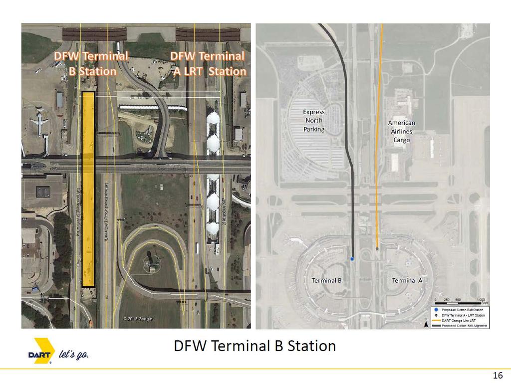
7 DFW Airport Terminal B Connection Alignment exits railroad corridor to connect to TEXRail alignment and serve DFW Airport Terminal B 5
8 6
9 DFW North Station 7
10 Freight Tracks Passenger Tracks Cypress Waters Alignment 8
11 Cypress Waters Station 9
12 Knoll Trail Station 10
13 Preston Road Station 11
14 Coit Road Station 12
15 Sanders Loop Future DFW Road (Road Over) S. Belt Line Road Future Dallas Road (Road Over) Cotton Belt Proposed Grade Separations 13
16 Coit Road (Road Over) Midway Road Cotton Belt Proposed Grade Separations
17 Upcoming Opportunities for Public Involvement Always Available DART web site: Letters Board Meetings Project Public Meetings and Hearings March 15, Noon: Facebook Live (DART s Facebook page) March 27, 2018: Service Plan Amendment Public Hearing April/May 2018: DEIS Public Hearing 15
18 16

19 Supplemental Information

20 DFW Airport Terminal B Connection Alignment exits railroad corridor to connect to TEXRail alignment and serve DFW Airport Terminal B 18

21 Freight Tracks Passenger Tracks Cypress Waters Alignment 19

22 Downtown Carrollton Reconfiguration Madill Sub grade separation Relocate Mercer Yard Cotton Belt bridge over BNSF Future Irving/Frisco Platform

23 Freight Tracks Passenger Tracks CityLine Alignment 21
24 Alignment Schematic DFW Airport 22
25 Alignment Schematic Cypress Waters 23
26 Alignment Schematic Carrollton 24
27 Alignment Schematic Addison/Dallas 25
28 Alignment Schematic Richardson 26
29 Alignment Schematic Plano 27
30 Stations
31 Station Guidance Station Name Location Input To Date* DFW DFWIA B Terminal Station DFW include in project 1 North DFW Station DFW include in project 2 Cypress Waters Station Dallas include in project 3 Downtown Carrollton Station Carrollton include in project 4 Addison Station Addison include in project 5 Knoll Trail Station Dallas include in project 6 Preston Rd Station Dallas candidate for elimination 7 Coit Rd. Station Dallas include in project 8 UT-Dallas Station Richardson include in project 9 CityLine/Bush Station Richardson include in project 10 12th Street Station (Light Rail and Cotton Belt) Plano include in project 11 Shiloh Station Plano include in project *Input received during Public and Board Meetings 29
32 2040 Ridership Scenarios STATION NAME Full Build Regional Model Full Build All Stations Without % Change Full Preston Station Build Without North Dallas Stations % Change Full Build DFWIA AB Terminal Station 3,950 1,170 1,170 0% 1,160-1% North DFW Station 900 1,320 1,330 1% 1,310-1% Cypress Waters Station % 890-2% Downtown Carrollton 4,000 1,970 1,930-2% 1,850-6% Station Addison Station 2,800 1,690 1,750 4% 1,940 15% Knoll Trail Station % Preston Rd Station Coit Rd. Station % UT-Dallas Station % 1,200 41% CityLine/Bush Station ,380 1,370-1% 1,240-10% 12th Street Station % 340-8% Shiloh Station % 690 5% Corridor Ridership 21,100 12,010 11,720-2% 10,620-12% 30
33 31
34 DFW North Station 32
35 Cypress Waters Station 33

36 Downtown Carrollton Station 34
37 Addison Station 35
38 Knoll Trail Station 36
39 Preston Road Station 37
40 Coit Road Station 38

41 UT Dallas Station 39
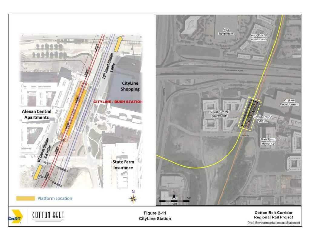
42 CityLine/Bush Station 40
43 12 th Street Station 41

44 Shiloh Road Station 42
45 NEPA Review Environmental Impacts and Mitigation
46 Environmental Review Notice of Intent (NOI) Published- July 8, 2010 Scoping Meeting - July 29, 2010 Administrative Draft now under review DEIS anticipated March/April 2018 DEIS Hearing anticipated April/May 2018 FEIS anticipated June 2018 RODs anticipated July
47 Impact and Mitigation Guidance Summary Impact Mitigation Input to Date* Noise Quiet Zones include in project Noise Sound Barriers include in project Noise Bell Mitigation include in project Vibration Tire Derived Aggregate (TDA) Material include in project Traffic Visual Visual Grade Separation Intersection and Signal improvements Landscaping Wheeler Bridge (Midway Road) Complementary Design include in project Coordinate with communities/cities include in project Historic Bridge Relocation/Adaptive Reuse include in project Parkland - Section 4(f) Trail Replacement include in project *Input received during Public and Board Meetings as of 3/8/18 45
48 Noise Impacts and Mitigation
49 Residential Noise Impact Summary Residential Noise Impact Without Quiet Zones Quiet Zones without Additional Mitigation Quiet Zones with Additional Mitigation City Moderate Severe Moderate Severe Moderate Severe Coppell Carrollton *2 0 Addison Dallas 968 1, Richardson Plano Total *2 0 * Additional mitigation to be considered 47

50 Example of Quiet Zone Quad Gates Quiet Zone = No Train Horn 48


")
51 Proposed Noise Mitigation Mitigation Corridor Coppell Carrollton Addison Dallas Richardson Plano Quiet Zones Crossing Bell Noise Barriers Noise Barrier Length (feet) 20,300-2,600-17, Example 49

52 Noise Barrier Locations Carrollton 50

53 Noise Barrier Locations North Dallas 51
54 Vibration Impacts and Mitigation

55 Vibration Impact Location Map Dallas and Carrollton Vibration Legend Vibration Impact 53

56 Proposed Vibration Mitigation Track treated with Tire Derived Aggregate (TDA) 54
57 Traffic Analysis and Mitigation
58 Crossing Configuration Summary 71 Roadway Crossings (1-71) 45 At-Grade 14 Existing Grade Separations 8 Proposed New Grade Separations 2 Future Grade Separations 1 Closure or remain grade separated 1 Closure 8 Non-Roadway Crossings (A-H) 1 At-Grade 6 Existing Grade Separations 1 Proposed Grade Separations 56
59 Roadway (Arterials Only) Mitigation Grade Separations and Signal/Design Improvements Roadway At-Grade Crossing City Insert (Crossing map Number) with location key LOS Impacts? Queuing Impacts? Recommended Traffic Mitigation Grade Separation (5 New) Treatment South Belt Line Road (16) Includes Sanders Loop (17) Coppell / Dallas Yes Yes Track over the Road Midway Road (37) Addison No Yes Track over the Road Coit Road (53) Dallas No Yes Roadway over the Track Custer Parkway (58) Richardson Yes Yes Track over the Road Plano Parkway (66) Plano Yes Yes Track over the Road Intersection Improvements (6) Treatment MacArthur Boulevard (21) Coppell Yes No Signal/Design Improvements Luna Road (26) Carrollton Yes Yes Signal/Design Improvements (Grade Separation not feasible) North Marsh Lane (35) Carrollton / Addison Yes Yes Signal/Design Improvements Addison Road (38) Addison Yes Yes Signal/Design Improvements (Grade Separation not feasible) Hillcrest Road (49) Dallas No No Signal/Design Improvements Alma Road (59) Richardson Yes Yes Signal/Design Improvements (Grade Separation not feasible) Note: All at-grade roadway crossings will be gated; residential areas will include quiet zones 57
 Cotton Belt")
60 Sanders Loop Future DFW Road (Road Over) S. Belt Line Road Future Dallas Road (Road Over) Cotton Belt Proposed Grade Separations 58

61 BNSF/ Madill Sub (Cotton Belt over BNSF) Cotton Belt Proposed Grade Separations 59

62 Coit Road (Road Over) Midway Road Cotton Belt Proposed Grade Separations

63 Custer Parkway Plano Parkway US 75 Red Moon Way Cotton Belt Proposed Grade Separations 61
64 Cotton Belt Proposed Roadway Crossing Configuration ID Location Name Type Configuration 1 DFW Crossunder # 2 Street At-Grade 2 DFW International Service Road Street Existing Grade Separation (Rail Under) 3 DFW North Employee Road Street At-Grade 4 DFW North Airfield Drive Street Existing Grade Separation (Rail Under) 5 DFW SH 121/SH 114 Freeway Existing Grade Separation (Rail Under) 6 DFW Dallas Road Street Future Grade Separation (Rail Under) 7 DFW Chesapeake Access Road Access At-Grade 8 DFW New DFW Road Street Future Grade Separation (Rail Under) 9 DFW DFW Fire Station 6 Road Driveway New At-Grade 10 DFW SH 121 Freeway Existing Grade Separation (Rail Under) 11 DFW IH 635, Freeway Existing Grade Separation (Rail Under) 12 Coppell Royal Lane Street At-Grade 13 Coppell Freeport Parkway Street At-Grade 14 Coppell Coppell Road Street At-Grade 15 Coppell Southwestern Boulevard Street At-Grade 16 Coppell South Belt Line Road Street Proposed Grade Separation 17 Coppell Sanders Loop Street Proposed Grade Separation 18 Dallas East Belt Line Road Street At-Grade 19 Coppell Moore Road Street At-Grade 20 Coppell Mockingbird Lane Street At-Grade 21 Coppell MacArthur Boulevard Street At-Grade 22 Coppell Fairway Drive Street At-Grade 23 Coppell Private /Ledbetter Road Driveway At-Grade 24 Carrollton Private (Gun Range Road) Driveway Existing Grade Separation (Rail Over) 62
65 Cotton Belt Proposed Roadway Crossing Configuration ID Location Name Type Configuration 25 Carrollton PGBT Freeway Existing Grade Separation (Rail Under) 26 Carrollton Luna Road Street At-Grade 27 Carrollton Unnamed dirt road (Utility) Access Existing underpass to be relocated 28 Carrollton IH-35E Freeway Existing Grade Separation (Rail Under) 29 Carrollton North Broadway Street Street At-Grade 30 Carrollton North Denton Drive Street At-Grade 31 Carrollton Perry Road Street At-Grade 32 Carrollton North Josey Lane Street At-Grade 33 Carrollton Kelly Boulevard Street At-Grade 34 Carrollton Private Driveway (Golf Club) Driveway Closed 35 Addison North Marsh Lane Street At-Grade 36 Addison Surveyor Boulevard Street At-Grade 37 Addison Midway Road Street Proposed Grade Separation 38 Addison Addison Road Street At-Grade 39 Addison Quorum Drive Street At-Grade 40 Addison Spectrum Drive Street At-Grade 41 Addison DNT SB Frontage Road Street At-Grade 42 Dallas Dallas North Tollway Freeway Existing Grade Separation (Rail Over) 43 Dallas DNT NB Frontage Road Street At-Grade 44 Dallas Knoll Trail Drive Street At-Grade 45 Dallas Preston Road, Street Existing Grade Separation (Rail Under) 46 Dallas Davenport Road (South) Street At-Grade 47 Dallas Campbell Road Street At-Grade 48 Dallas Davenport Road Street At-Grade 63
66 Cotton Belt Proposed Roadway Crossing Configuration ID Location Name Type Configuration 49 Dallas Hillcrest Road Street At-Grade 50 Dallas McCallum Boulevard Street At-Grade 51 Dallas Meandering Way Street At-Grade 52 Dallas Dickerson Street Street At-Grade 53 Dallas Coit Road Street Proposed Grade Separation 54 Richardson Waterview Parkway Street At-Grade 55 Richardson Rutford Avenue Street New At-Grade 56 Richardson Synergy Park Boulevard Street Existing Grade Separation (Rail Over) 57 Richardson Renner Road Street Existing Grade Separation (Rail Over) 58 Richardson Custer Parkway Street Proposed Grade Separation 59 Richardson Alma Road Street At-Grade 60 Richardson US 75 Freeway Proposed Grade Separation 61 Richardson Red Moon Way Street Proposed Grade Separation 62 Richardson W. CityLine Drive Street At-Grade 63 Plano PGBT EB Frontage Road Street At-Grade 64 Plano PGBT Freeway Existing Grade Separation (Rail Under) 65 Plano PGBT WB Frontage Road Street At-Grade 66 Plano Plano Parkway Street Proposed Grade Separation 67 Plano K Avenue Street At-Grade 68 Plano Municipal Avenue Street At-Grade 69 Plano N Avenue Street At-Grade 70 Plano Jupiter Road Street At-Grade 71 Plano Shiloh Road Street At-Grade 64
67 Proposed Non-Roadway Crossing Configuration ID Location Name Type Configuration A DFW Skylink People Mover APM Existing Grade Separation (APM Over) B DFW Taxiway Z Taxiway Existing Grade Separation (Taxiway Over) C DFW Taxiway Y Taxiway Existing Grade Separation (Taxiway Over) D Carrolton UP Railroad Railroad At-Grade E Carrolton DART Green Line LRT Existing Grade Separation (LRT Over) F Carrolton BNSF/Madill Subdivision Railroad Proposed Grade Separation G Richardson KCS Railroad Railroad Existing Grade Separation (KCS Over) H Plano DART Red Line LRT Existing Grade Separation (LRT Over) 65
68 Visual Mitigation
69 Visual Mitigation Examples Typical landscaping at foot intervals along residential areas for: Visual screening Soften views of sound walls, corridor fencing (where possible) Preservation of existing vegetation Station landscaping/appropriate lighting in residential areas Station materials/finishes to complement surrounding character Complementary structure design Public and agency coordination to define types of vegetation 67
70 Other Impacts and Mitigation


71 Other Impacts Identified in DEIS 1 2 Cottonwood Creek Floodplain Encroachment - DFW 4 Wheeler Signature Bridge - Addison White Rock Creek Bridge Reuse - Dallas Spring Creek Trail Relocation - Richardson 69


72 Relocation of Mercer Yard Existing rail yard in downtown Carrollton to be relocated approximately two miles to the east 70


73 Proposed TRE Facility Expansion 71
74 Design Considerations

75 Presented August 2016 Public Meetings 73
76 Proposed Noise Wall Cross-Section One Noise Barrier Wall Two Noise Barrier Walls 74

77 Example Wall Treatment 7 ft Height 75

78 Example Wall Treatment 15 ft Height 76


79 Design Examples Fencing in Residential Areas Channelized Pedestrian Crossings (TCRP Report 69) Pedestrian Gates 77
 Los Angeles - Orange Line BRT (dedicated fixed")
80 Increased Aesthetics Example Hike/Bike Trail, Planting, Fencing, Wall (Residential Area) Los Angeles - Orange Line BRT (dedicated fixed guideway) 78
Cotton Belt Regional Rail Corridor Project
 Cotton Belt Regional Rail Corridor Project North Dallas AFG University of Texas at Dallas Administration Building March 1, 2018 0 Discussion Public Involvement Project Scope Alignment Stations Environmental
Cotton Belt Corridor. Area Focus Group (AFG) Richardson/Plano August 24, John Hoppie, Capital Planning
 Richardson/Plano August 24, John Hoppie, Capital Planning") Cotton Belt Corridor Area Focus Group (AFG) Richardson/Plano August 24, 2017 John Hoppie, Capital Planning 0 Agenda Design Update Environmental Update Documentation of Existing Conditions Noise Traffic
Cotton Belt Corridor Area Focus Group (AFG) Richardson/Plano August 24, 2017 John Hoppie, Capital Planning 0 Agenda Design Update Environmental Update Documentation of Existing Conditions Noise Traffic
REQUEST FOR SHPO CONSULTATION: Projects Subject to Section 106 of the National Historic Preservation Act and/or the Antiquities Code of Texas
 REQUEST FOR SHPO CONSULTATION: Projects Subject to Section 106 of the National Historic Preservation Act and/or the Antiquities Code of Texas Submission of this form only initiates consultation with the
Honorable Members of the Mobility Solutions, Infrastructure and Sustainability Committee
 Memorandum DATE January 23, 2019 CITY OF DALLAS TO Honorable Members of the Mobility Solutions, Infrastructure and Sustainability Committee SUBJECT I-30 East Project Update On Monday, January 28, 2019,
Cotton Belt Corridor Regional Rail
 Cotton Belt Corridor Regional Rail Visual Impact Assessment Technical Memorandum December 2013 Prepared for Dallas Area Rapid Transit General Planning Consultant Managed by URS Corporation Cotton Belt
Honorable Members of the Public Safety and Criminal Justice Committee Fire Watch Procedures
 Memorandum DATE November 16, 2018 TO SUBJECT Honorable Members of the and Criminal Justice Committee Fire Watch Procedures On Monday, November 26, 2018, you will be briefed on the Dallas Fire-Rescue (DFR)
Appendix B. Technical Memoranda and Reports
 Cotton Belt Corridor Regional Rail Project Draft Environmental Impact Statement Appendix B Technical Memoranda and Reports Technical memoranda and reports were prepared as independent documents to support
Memorandum CITY OF DALLAS
 Memorandum DATE September 23, 2016 CITY OF DALLAS TO The Honorable Members of the Transportation and Trinity River Project Committee: Lee M. Kleinman (Chair), Deputy Mayor Pro Tem Erik Wilson (Vice-Chair),
Cotton Belt Corridor Regional Rail
 Cotton Belt Corridor Regional Rail Socioeconomic Impact Assessment Technical Memorandum December 2013 Prepared by URS Corporation Prepared for Dallas Area Rapid Transit General Planning Consultant Managed
Memorandum CITY OF DALLAS. Riverfront Boulevard Design From Continental Avenue to Cadiz Street
 Memorandum DATE November 10, 2011 CITY OF DALLAS TO Trinity River Corridor Project Committee Members: Vonciel Jones Hill (Chair) Linda Koop (Vice Chair), Monica Alonzo, Scott Griggs, Angela Hunt, and Delia
Cotton Belt Corridor Regional Rail; Land Use Existing Conditions Technical Memorandum. John Hoppie, Project Manager, DART Capital Planning
 MEMO Date: Tuesday, August 01, 2017 Project: To: From: Subject: Cotton Belt Corridor Regional Rail; Land Use Existing Conditions Technical Memorandum John Hoppie, Project Manager, DART Capital Planning
Cotton Belt Corridor Regional Rail
 Cotton Belt Corridor Regional Rail Land Use Existing Conditions Technical Memorandum December 2013 Prepared by URS Corporation Prepared for Dallas Area Rapid Transit General Planning Consultant Managed
Exhibit A. SH 161 RTC Work Program of New Projects. Collin County
 Exhibit A SH 161 RTC Work Program of New Projects Collin County 0918-24-969 N/A 0918-24-970 N/A 0918-24-973 N/A 2351-01-020 N/A 2679-03-010 N/A On Exchange Parkway from US 75 to Allen Heights On Country
Memorandum CITY OF DALLAS
 Mayor Memorandum CITY OF DALLAS DATE February 10, 2017 TO: Honorable Members of the Public Safety Committee: Adam Medrano (Chair), B. Adam McGough (Vice Chair), Sandy Greyson, Tiffinni A. Young, Jennifer
Northwest Rail Corridor and US 36 BRT Development Oriented Transit Analysis 4.4 STATION AREA FINDINGS
 4.4 STATION AREA FINDINGS Each station is different, and each one requires a separate set of recommendations based on the vision for the site. This section outlines an initial TOD strategy and recommendations
U T D N o r t h C a m p u s T O D and D o w n t o w n D e n t o n T O D
 U n i v e r s i t y o f T e x a s a t D a l l a s C i t y o f R i c h a r d s o n U T D N o r t h C a m p u s T O D and D o w n t o w n D e n t o n T O D Rick Leisner, AICP Assistant Director of Development
Northwest Corridor LRT Line to Irving/DFW Public Meeting No. 1 Project Overview
 LRT Line to Irving/DFW Public Meeting No. 1 Project Overview January 21, 2004 Agenda Purpose Corridor Background Environmental Impact Assessment Public Involvement Plan Project Schedule Purpose Project
Emergency Management. questions. need
 Memorandum CITY OF DALLAS DATE. TO December 9, 2016 Honorable Members of the Public Committee: Adam Medrano (Chair), B. Adam McGough (Vice Chair), S. Philip T. Kingston Jennifer Gates, Safety Sandy Greyson,
Appendix B. Technical Memoranda and Reports
 Cotton Belt Corridor Regional Rail Project Draft Environmental Impact Statement Appendix B Technical Memoranda and Reports Technical memoranda and reports were prepared as independent documents to support
East Corridor Final Environmental Impact Statement
 East Corridor Final Environmental Impact Statement Alternatives Considered Operating Plan The requirements for opening day operations versus year 2030 are based on ridership and operations. Opening day
RESOLUTION NO. R Refining the route, profile and stations for the Downtown Redmond Link Extension
 RESOLUTION NO. R2018-32 Refining the route, profile and stations for the Downtown Redmond Link Extension MEETING: DATE: TYPE OF ACTION: STAFF CONTACT: Capital Committee Board PROPOSED ACTION 09/13/2018
Memorandum CITY OF DALLAS
 Memorandum CITY OF DALLAS DATE: October 7, 2016 TO: SUBJECT: Honorable Members of the Public Safety Committee: Adam Medrano (Chair), B. Adam McGough (Vice Chair), Sandy Greyson, Tiffinni A. Young, Jennifer
Elm Fork Land Use. Trinity River Corridor Project Committee May 13, 2013
 Elm Fork Land Use Trinity River Corridor Project Committee May 13, 2013 Purpose Discuss Trinity River planned Land Use and Appropriate Compatible Uses, particularly with respect to the Elm Fork Area 2
Chesterfield County Project Update
 Chesterfield County Project Update SOUTHEAST HIGH SPEED RAIL TIER II ENVIRONMENTAL IMPACT STATEMENT RICHMOND, VA, TO RALEIGH, NC CHESTERFIELD COUNTY, VA OFFICIALS BRIEFING February 2013 Federal Railroad
WEST OAK CLIFF RED LINE EXTENSION
 INITIAL ALTERNATIVES CORRIDOR EVALUATION WEST OAK CLIFF RED LINE EXTENSION Hampton C O R R I D O R I N F O R M AT I O N 408 303 Keist Keist Blvd Duncanville Rd 2 Red Bird Ln Executive Airport Boulder "
IH35 Corridor Plan Amendment to the Comprehensive Plan
 IH35 Corridor Plan Amendment to the Comprehensive Plan Background The corridor plan for the IH35 corridor is an amendment to the Burleson comprehensive plan. Generally, the purpose of a corridor plan is
DOMINION BOULEVARD CORRIDOR STUDY AND ECONOMIC DEVELOPMENT STRATEGIC PLAN A MODEL FOR CHESAPEAKE S FUTURE
 DOMINION BOULEVARD CORRIDOR STUDY AND ECONOMIC DEVELOPMENT STRATEGIC PLAN A MODEL FOR CHESAPEAKE S FUTURE Overview I. Draft Plan Process II. Draft Plan Overview a. Market Analysis b. Master Land Use Plan
Q:%4~ Memorandum CITY OF DALLAS
 Memorandum DATE December 10, 2010 CITY OF DALLAS TO Members of the Transportation and Environment Committee: Linda Koop (Chair), Sheflie Kadane (Vice Chair), Pauline Medrano, Vonciel Jones Hill, Jerry
APPENDIX D: Visual and Aesthetic Conditions for NCCU Station Refinement. Durham-Orange Light Rail Transit Project
 APPENDIX D: Visual and Aesthetic Conditions for NCCU Station Refinement Durham-Orange Light Rail Transit Project October 2016 1. Introduction The Combined FEIS/ROD summarizes the effects of the D-O LRT
BeltLine Corridor Environmental Study
 BeltLine Corridor Environmental Study Joint TAC and SAC Meeting December 8, 2008 What We Will Discuss Today Outreach and Agency Coordination Scoping Results Existing Conditions Historical and Archeological
State Highway 121 Southwest Parkway. Fort Worth s Transportation Success Story in Design and Cooperation
 State Highway 121 Southwest Parkway Fort Worth s Transportation Success Story in Design and Cooperation Greater Fort Worth Association of Realtors October 24, 2007 Presented by: Dan Lamers, P.E. North
Belt Line Corridor Vision
 Vision BACKGROUND Belt Line Road is Addison s Main Street. Until recently it was one of the strongest restaurant and retail corridors in the region. However, due to competition from other communities to
METRO Gold Line BRT CMC Meeting
 METRO Gold Line BRT CMC Meeting April 26, 2018 Today s Topics Welcome and Introductions Project Overview CMC Roles and Responsibilities Current Project Baseline: Scope and Cost Estimate Overview Municipal
Good Neighbor Plan Dallas Love Field Airport Transportation and Environment Committee
 June 25, 2012 Good Neighbor Plan Dallas Love Field Airport Transportation and Environment Committee Overview Vision for Dallas Love Field Downtown Dallas 360 Plan Targeted Improvement Zones Lemmon Avenue
IH35 Corridor Plan Amendment to the Comprehensive Plan
 IH35 Corridor Plan Amendment to the Comprehensive Plan Background The corridor plan for the IH35 corridor is an amendment to the Burleson comprehensive plan. Generally, the purpose of a corridor plan is
Atlanta BeltLine Corridor Environmental Study. Scoping Meeting August 2008
 Atlanta BeltLine Corridor Environmental Study Scoping Meeting August 2008 What Will We Be Discussing Today? Study Overview - How Did We Get Here? - What Is the Study About? - Who Is Involved? - Where Is
APPENDIX F DRAFT SECTION 4(f) EVALUATION
 EVALUATION") APPENDIX F DRAFT SECTION 4(f) EVALUATION APPENDIX F DRAFT SECTION 4(f) EVALUATION Section 4(f) of the Department of Transportation Act of 1966, as amended, (49 United States Code (USC) 303) states that
APPENDIX F DRAFT SECTION 4(f) EVALUATION APPENDIX F DRAFT SECTION 4(f) EVALUATION Section 4(f) of the Department of Transportation Act of 1966, as amended, (49 United States Code (USC) 303) states that
SH 199 Corridor Master Plan. Community Meeting No. 2 May 31, 2017
 Community Meeting No. 2 May 31, 2017 Transportation Projects On or Near SH 199 SH 199 from 0.3 miles south of FM 1886 to south end of Lake Worth bridge Construct freeway mainlanes and frontage roads 10-Year
Southern Gateway Project and Public Green
 Southern Gateway Project and Public Green Transportation and Trinity River Project Committee May 23, 2016 Purpose of Presentation Provide the history and an overview of the Southern Gateway Project (SGP)
Regional Mobility & the US 380 Bypass Concept. Informational Meeting February 9, 2017
 Regional Mobility & the US 380 Bypass Concept Informational Meeting February 9, 2017 Purpose and Agenda Purpose: Regional Mobility Issues, Priorities, and Pressures US 380 as a Limited Access Facility
City Council Special Meeting AGENDA ITEM NO. C.
 City Council Special Meeting AGENDA ITEM NO. C. DATE: 01/04/2019 TO: Honorable Mayor and City Council Members SUBJECT: Transit Villages Specific Plan project Study Session (Development Services Director
Appendix D Community Impact Assessment
 Appendix D Community Impact Assessment This page is intentionally blank. Mid-City/Exposition Light Rail Transit Project Community Impact Assessment Memorandum for the Improvements at Farmdale Avenue and
Northwest Corridor LRT Line to Irving/DFW. Mandalay Place HOA February 7, 2005
 Northwest Corridor LRT Line to Irving/DFW Mandalay Place HOA February 7, 2005 Agenda: Introductions North Lake College Station Issues from November Meeting Recommendations Q & A Proposed Grade Separation
Date: April 10, 2017 City Council Work Session April 24, 2017: Status Report on the Comprehensive Plan Update and Transportation Master Plan
 AGENDA REPORT To: From: By: Honorable Mayor and City Council Members Warren Hutmacher, City Manager Sharon Ebert, Director Community Development Date: April 10, 2017 Agenda: City Council Work Session April
I. DESCRIPTION OF PROPOSED ACTION... 1 A. General Description... 1 B. Historical Resume and Project Status... 2 C. Cost Estimates...
 PROJECT COMMITMENTS SUMMARY... S-1 1. Type of Action... S-1 2. Description of Action... S-1 3. Summary of Purpose and Need... S-1 4. Alternatives Considered... S-2 5. NCDOT Alternatives Carried Forward...
Dallas CBD Second Light Rail Alignment (D2)
") Dallas CBD Second Light Rail Alignment (D2) Subway Project Refinement Public Meetings January 19, 2017 Discussion Items Background Schedule Public/Stakeholder Involvement Subway Construction Overview Potential
Dallas CBD Second Light Rail Alignment (D2) Subway Project Refinement Public Meetings January 19, 2017 Discussion Items Background Schedule Public/Stakeholder Involvement Subway Construction Overview Potential
CITY OF CHARLOTTESVILLE, VIRGINIA CITY COUNCIL AGENDA
 CITY OF CHARLOTTESVILLE, VIRGINIA CITY COUNCIL AGENDA Agenda Date: December 16, 2013 Action Required: Adoption of Resolution Presenter: Staff Contacts: Title: James E. Tolbert, AICP, Director of NDS James
Inglewood Transit Connector Environmental Impact Report Scoping Meeting July 26, 2018
 Inglewood Transit Connector Environmental Impact Report Scoping Meeting July 26, 2018 Tonight s Speakers and Key Staff City of Inglewood Honorable Mayor James T. Butts, Jr. Louis A. Atwell, Director, Public
CHAPTER 1. Ms. Guajardo s Class - Central Elementary CH 1 1
 INTRODUCTION CHAPTER 1 Ms. Guajardo s Class - Central Elementary CH 1 1 1.1 SETTING South Centre City is a linear corridor south of Downtown Escondido paralleling Centre City Parkway and South Escondido
METRO Gold Line BRT CBAC Meeting. August 23, 2018
 METRO Gold Line BRT CBAC Meeting August 23, 2018 1 Today s Topics Introductions Corridor Management Committee Update Public Engagement Update History of Alignment Project Scope Discussions Upcoming CBAC
ARLINGTON COUNTY, VIRGINIA. County Board Agenda Item Meeting of January 28, 2017 SUPPLEMENTAL REPORT
 ARLINGTON COUNTY, VIRGINIA County Board Agenda Item Meeting of January 28, 2017 SUPPLEMENTAL REPORT DATE: January 26, 2017 SUBJECT: The Virginia Department of Transportation s Transform I-66 Inside the
Staff Report CONDITIONAL USE
 Staff Report PLANNING DIVISION COMMUNITY & ECONOMIC DEVELOPMENT To: From: Salt Lake City Planning Commission Daniel Echeverria, (801) 535-7165, daniel.echeverria@slcgov.com Date: May 21, 2015 Re: PLNPCM2015-00139
Kankakee River Bridge & Track Improvements Supplemental Environmental Assessment. May 5, 2016
 Kankakee River Bridge & Track Improvements Supplemental Environmental Assessment May 5, 2016 1 History: Chicago-St. Louis Corridor Since 1980 s IDOT has been looking at this corridor for high-speed service
Railyard Alternatives and I-280 Boulevard Feasibility Study. MTA Board Meeting May 6, 2014
 Railyard Alternatives and I-280 Boulevard Feasibility Study MTA Board Meeting May 6, 2014 Planned Infrastructure Major pieces of new infrastructure are planned including: Downtown Rail Extension (DTX)
SBCAG STAFF REPORT. MEETING DATE: March 17, 2016 AGENDA ITEM: 5I
 SBCAG STAFF REPORT SUBJECT: Cabrillo-UPRR Bridge Project MEETING DATE: March 17, 2016 AGENDA ITEM: 5I STAFF CONTACT: Fred Luna RECOMMENDATION: Authorize the chair to sign a Memorandum of Understanding
Mississippi Skyway Preliminary Engineering Report
 EXECUTIVE SUMMARY Mississippi Skyway Preliminary Engineering Report CITY OF RAMSEY, MINNESOTA DECEMBER 2014 City of RAMSEY EXECUTIVE SUMMARY Project Need and Intent The Mississippi Skyway pedestrian bridge
Right-of-Way Acquisitions and Relocations Technical Memorandum
 Right-of-Way Acquisitions and Relocations Technical Memorandum Southeast Extension Project Lincoln Station to RidgeGate Parkway Prepared for: Federal Transit Administration Prepared by: Denver Regional
Northern Branch Corridor SDEIS March Table of Contents
 Table of Contents Executive Summary... ES-1 ES.1 Introduction... ES-1 ES.2 Project Background... ES-1 ES.3 Purpose and Need... ES-5 ES.4 Alternatives... ES-6 ES.5 Operating Plan... ES-11 ES.6 Cost Analysis...
Corridor Management Committee. September 29, 2017
 Corridor Management Committee September 29, 2017 1 Today s Topics Chair s Update Proposed Corridor Protection Wall Aesthetic Design Overview Public Outreach Environmental Review Civil Construction Update
Implementation Guide Comprehensive Plan City of Allen
 Implementation Guide 2030 Comprehensive Plan City of Allen DRAFT 2015 Implementation Guide Allen 2030 Comprehensive Plan INTRODUCTION The Comprehensive Plan serves as a guide for the growth and development
Central Corridor Light Rail Transit. Environmental Assessment Three Infill Stations. Western, Victoria, and Hamline
 Central Corridor Light Rail Transit Environmental Assessment Three Infill Stations Western, Victoria, and Hamline Metropolitan Council January 2010 ABSTRACT The Metropolitan Council on behalf of the Federal
Chapter 2: Preliminary Analysis
 State Highway 5 Corridor Context Sensitive Master Plan ADOPTED June 17, 2014 (Resolution 2014-06-071) Chapter 2: Preliminary Analysis Before looking to the future of the State Highway 5 (SH 5) Corridor,
Scope of Services. River Oaks Boulevard (SH 183) Corridor Master Plan
 Corridor Master Plan") Scope of Services River Oaks Boulevard (SH 183) Corridor Master Plan PROJECT AREA The project area consists of the River Oaks Boulevard (SH 183) corridor bounded by SH 199 at the northern end and the Trinity
Scope of Services River Oaks Boulevard (SH 183) Corridor Master Plan PROJECT AREA The project area consists of the River Oaks Boulevard (SH 183) corridor bounded by SH 199 at the northern end and the Trinity
Transportation Committee
 Transportation Committee Business Item No. 2013-286SW Meeting date: October 14, 2013 For the Metropolitan Council meeting of October 16, 2013 Subject: Southwest Light Rail Transit (Green Line Extension):
3.5 VISUAL AND AESTHETIC QUALITIES
 3.5 VISUAL AND AESTHETIC QUALITIES 3.5.1 Introduction to Analysis 3.5.1.1 Summary of Results The Preferred Alternative would represent a minimal change to the visual character of the existing rail corridor.
Physical Map Revision Flood Insurance Study
 Physical Map Revision Flood Insurance Study Collin County, Texas Over the Shoulder Review Meeting Draft Floodplain Mapping 1 October 26, 2011 Presentation Overview Introductions and Sign in Meeting Purpose
Asheville Design Center March 2010
 Community-Based Design Update Asheville Design Center March 2010 www.ashevilledesigncenter.org 1 introduction contents 1. Introduction 2. Background 3. ovember Design Charrette 4. January Work Session
CITY OF LARKSPUR Staff Report. August 21, 2013 Council Meeting UPDATE ON TRANSPORTATION AUTHORITY OF MARIN (TAM) GREENBRAE CORRIDOR WORKING GROUP
 GREENBRAE CORRIDOR WORKING GROUP") AGENDA ITEM 7.1 CITY OF LARKSPUR Staff Report August 21, 2013 Council Meeting DATE: August 16, 2013 TO: FROM: SUBJECT: Honorable Mayor Hillmer and Members of the City Council Dan Schwarz, City Manager
AGENDA ITEM 7.1 CITY OF LARKSPUR Staff Report August 21, 2013 Council Meeting DATE: August 16, 2013 TO: FROM: SUBJECT: Honorable Mayor Hillmer and Members of the City Council Dan Schwarz, City Manager
Gold Line Bus Rapid Transit Transit Oriented Development (BRTOD) Helmo Station Area Plan
 Helmo Station Area Plan") Appendix F Gold Line Bus Rapid Transit Transit Oriented Development (BRTOD) Helmo Station Area Plan Introduction and Purpose of the Plan The Gold Line Bus Rapid Transit facility is an eleven-mile dedicated
Appendix F Gold Line Bus Rapid Transit Transit Oriented Development (BRTOD) Helmo Station Area Plan Introduction and Purpose of the Plan The Gold Line Bus Rapid Transit facility is an eleven-mile dedicated
BeltLine Corridor Environmental Study
 BeltLine Corridor Environmental Study Citywide Conversation on Transit and Trails April 2, 2009 Agenda & Introductions Introductions Environmental Study Process Overview of the BeltLine Project BeltLine
I. INTRODUCTION. Project Background and Study Area
 I. INTRODUCTION Project Background and Study Area Freedom Parkway is a key east-west corridor connecting I-25 on the west to the Town of Kersey on the east, running approximately one to two miles south
THE GARDEN CITY PLAN. City of St. Catharines Official Plan. City of St. Catharines
 THE GARDEN CITY PLAN City of St. Catharines Official Plan City of St. Catharines August 2010 APPROVAL INFORMATION This Official Plan of the City of St. Catharines Planning Area, known as the Garden City
Local Growth Planning in North Central Green Line Communities
 2018 April 30 Page 1 of 6 EXECUTIVE SUMMARY This report outlines a high-level scope for local growth planning for north central Green Line communities. The catalyst for this review is the significant investments
D2 Subway Project Development. Public Meeting September 12, 2018
 D2 Subway Project Development Public Meeting September 12, 2018 1 Agenda Project Background Process, Funding and Schedule Project Development (PD) Efforts Preliminary Engineering (PE) Environmental Impact
Public Open House. Welcome! Presentation at 5:15 p.m. Please sign-in at the registration table
 Public Open House Welcome! Presentation at 5:15 p.m. Please sign-in at the registration table The Grand Avenue Extension Location and Environmental Study will determine the location of the extension of
Kanata Light Rail Transit Planning and Environmental Assessment Study
 Kanata Light Rail Transit Planning and Environmental Assessment Study Public Open House #2 Transportation Services Department December 7, 2017 Agenda Review study progress Confirm the Preferred Corridor
CITY COUNCIL AGENDA REPORT
 CITY COUNCIL AGENDA REPORT Subject: COUNCIL MOTION LRT ALIGNMENT REMOVAL FROM THE TRANSPORTATION MASTER PLAN On February 10, 2016 Councillor Hughes provided notice in accordance with Section 23 of Procedure
ARGENTA TRAIL (CSAH 28/63) REALIGNMENT SOUTH PROJECT (CP 63-25)
 REALIGNMENT SOUTH PROJECT (CP 63-25)") ARGENTA TRAIL (CSAH 28/63) REALIGNMENT SOUTH PROJECT (CP 63-25) Preliminary Design Report February 2015 Prepared For: City of Inver Grove Heights Dakota County Prepared By: Kimley-Horn and Associates,
ARGENTA TRAIL (CSAH 28/63) REALIGNMENT SOUTH PROJECT (CP 63-25) Preliminary Design Report February 2015 Prepared For: City of Inver Grove Heights Dakota County Prepared By: Kimley-Horn and Associates,
Midtown Corridor Alternatives Analysis. Appendix A - Initially Considered Alternatives Screening
 Midtown Corridor Alternatives Analysis Appendix A - Initially Considered Alternatives Screening Arterial BRT on Lake Street - Overall Rating: RATING Metropolitan Council recommendations stated in the Transportation
4.500 Preston Road Overlay District
 Section 4.500 Preston Road Overlay District 2004 Zoning Ordinance 4.500 Preston Road Overlay District (ZC 98-29; Ordinance No. 98-9-12) 4.501 Purpose To provide appropriate design standards for the use
ARLINGTON COUNTY, VIRGINIA. County Board Agenda Item Meeting of January 28, 2017 SUPPLEMENTAL REPORT-2
 ARLINGTON COUNTY, VIRGINIA County Board Agenda Item Meeting of January 28, 2017 SUPPLEMENTAL REPORT-2 DATE: January 27, 2017 SUBJECT: The Virginia Department of Transportation s Transform I-66 Inside the
Elgin O Hare Western Access Project Local Advisory Committee. February 10, 2014
 Elgin O Hare Western Access Project Local Advisory Committee February 10, 2014 Agenda Project status update Design and construction Funding Aesthetics Project events and outreach Land acquisition Next
Executive Summary. NY 7 / NY 2 Corridor
 Executive Summary NY 7 / NY 2 Corridor Transportation and Land Use Study December 2005 Prepared for: Town of Colonie Capital District Transportation Committee Prepared by: Introduction: Land use decisions
The Trinity River Corridor Project Update
 The Trinity River Corridor Project Update Councilmember Carolyn A. Davis Community Meeting October 14, 2008 The project covers 20 miles of the Trinity River, approx. 10,000 acres 2 Trinity River Corridor
Bassett Creek Valley Working Group. October 4, 2017
 Bassett Creek Valley Working Group October 4, 2017 1 Today s Topics Introductions Overview of Design Teams (P+W and WSP) Expertise Working Group Roles and Responsibilities Schedule & Community Engagement
Silver Line Gateway. Extension of Silver Line Bus Rapid Transit (BRT) to Chelsea and East Boston. Public Informational Meeting Chelsea, MA
 to Chelsea and East Boston. Public Informational Meeting Chelsea, MA") Silver Line Gateway Extension of Silver Line Bus Rapid Transit (BRT) to Chelsea and East Boston Public Informational Meeting Chelsea, MA August 18, 2014 Introduction / Design Process Design Team Joe Pavao,
Silver Line Gateway Extension of Silver Line Bus Rapid Transit (BRT) to Chelsea and East Boston Public Informational Meeting Chelsea, MA August 18, 2014 Introduction / Design Process Design Team Joe Pavao,
D2 Subway Project Development. Interagency Meeting July 27, 2018
 D2 Subway Project Development Interagency Meeting July 27, 2018 1 Agenda Welcome and Introductions Project Background D2 Project Overview Project Development (PD) Efforts Preliminary Engineering (PE) Environmental
PLNPCM Carl s Jr. Commercial Parking Lot at Redwood Road and 1700 South
 Staff Report PLANNING DIVISION COMMUNITY & NEIGHBORHOODS To: Salt Lake City Planning Commission From: Casey Stewart; 801-535-6260 Date: November 4, 2016 Re: PLNPCM2015-00874 Carl s Jr. Commercial Parking
Dallas CBD Second Light Rail Alignment (D2)
") Dallas CBD Second Light Rail Alignment (D2) Subway Project Refinement City of Dallas Transportation and Trinity River Project Committee February 13, 2017 Discussion Items Background Schedule Public/Stakeholder
Dallas CBD Second Light Rail Alignment (D2) Subway Project Refinement City of Dallas Transportation and Trinity River Project Committee February 13, 2017 Discussion Items Background Schedule Public/Stakeholder
TRANSPORTATION ELEMENT GOALS, OBJECTIVES, AND POLICIES
 TRANSPORTATION ELEMENT GOALS, OBJECTIVES, AND POLICIES GOAL 2 The City shall provide a safe, convenient, effective, and energy efficient multimodal transportation system which is coordinated with the Future
2. AGENCY COORDINATION AND PUBLIC INVOLVMENT
 2. AGENCY COORDINATION AND PUBLIC INVOLVMENT This chapter discusses the process carried out for conducting agency coordination and public involvement activities. TECHNICAL ADVISORY COMMITTEE A Technical
DOWNTOWN REDMOND LINK EXTENSION SEPA Addendum to the East Link Project Final Environmental Impact Statement
 DOWNTOWN REDMOND LINK EXTENSION 2018 SEPA Addendum to the East Link Project Final Environmental Impact Statement AUGUST 2018 Downtown Redmond Link Extension SEPA Addendum to the 2011 East Link Project
FANSHAWE PARK ROAD/RICHMOND STREET INTERSECTION IMPROVEMENTS. PUBLIC INFORMATION CENTRE 2 June 16, 2016
 FANSHAWE PARK ROAD/RICHMOND STREET INTERSECTION IMPROVEMENTS Municipal Class Environmental Assessment PUBLIC INFORMATION CENTRE 2 June 16, 2016 ACCESSIBILITY Under the Accessibility Standards 2015 for
PREPARED FOR: PLATTEVIEW ROAD CORRIDOR STUDY EXECUTIVE SUMMARY
 PREPARED FOR: PLATTEVIEW ROAD CORRIDOR STUDY EXECUTIVE SUMMARY SEPTEMBER 2016 Introduction The Platteview Road Corridor Study was led by the Metropolitan Area Planning Agency (MAPA) with assistance from
S C O P E O F W O R K A P R I L
 white flint 2 sector plan S C O P E O F W O R K A P R I L 2 0 1 2 MONTGOMERY COUNTY PLANNING DEPARTMENT M-NCPPC MontgomeryPlanning.org 1 white flint 2 sector plan Scope of Work abstract This scope of work
Clay Street Bridge Replacement Project
 Clay Street Bridge Replacement Project Frequently Asked Questions (FAQs) No. 2 April 4, 2018 The project is located in downtown Placerville on Clay Street between US Highway 50 and Main Street and Cedar
AMENDMENT NUMBER 2 TO AGREEMENT FOR PROFESSIONAL SERVICES BETWEEN URS CORPORATION GREAT LAKES AND THE CITY OF ANN ARBOR
 AMENDMENT NUMBER 2 TO AGREEMENT FOR PROFESSIONAL SERVICES BETWEEN URS CORPORATION GREAT LAKES AND THE CITY OF ANN ARBOR The City of Ann Arbor, a Michigan municipal corporation, with offices at 301 E. Huron
Sustainable Development Call for Projects Western Infrastructure Project Submissions
 2009-2010 Sustainable Development Call for Projects Western Infrastructure Project Submissions January 20, 2010 2009-2010 SDCFP Summary of Infrastructure Funding Infrastructure Projects Number of Projects
North Somerset Council Local Development Framework
 North Somerset Council Local Development Framework Sites and Policies Development Plan Document Evidence Paper Re-opening Portishead Railway Line and Options for the Location of Portishead Railway Station
Overall Map. Chicago. St. Louis. Summit. Joliet. Dwight. Pontiac. Bloomington-Normal Lincoln. Springfield. Carlinville. Alton EXPERIENCE IT YOURSELF.
 Overall Map Summit Chicago Bloomington-Normal Lincoln New Station Planned New Station Planned Dwight Pontiac Joliet Pedestrian overpass and second platform planned Higher speed service began in this section