|
|
|
- Amber Booker
- 6 years ago
- Views:
Transcription
1

2

3
4

5
6
7
8

9
10

11
12
13
14
15
16
17
18
19
20

21
22
23
24
25

26
27
28
29
30

31

32

33
34
35
36
37
 Amendment Number 7 8 February 15, 2013 February 19, 2014 City of Port St.")
38 EXHIBIT A Presented to: City of Port St. Lucie Planning and Zoning Department 121 SW Port St. Lucie Boulevard Port St. Lucie, Florida PLANNED UNIT DEVELOPMENT APPLICATION Verano PUD 1 (FKA PGA Village/Montage) Amendment Number 7 8 February 15, 2013 February 19, 2014 City of Port St. Lucie Project No: P P Approval date PSL Prj No.: Ord No.: Original Base 10/25/04 P Ord Amendment #1 09/25/06 P Ord Amendment #2 06/11/07 P Ord Amendment #3 09/10/07 P Ord Amendment #4 03/24/08 P Ord Amendment #5 11/23/09 P Ord Amendment #6 10/11/10 P Ord Amendment #7 5/13/13 P Ord Amendment #8 Pending Pending Pending Prepared by: Cotleur & Hearing, Inc Commerce Lane, Suite 1 Jupiter, FL Ph
39 Verano PUD 1 Amendment Number 7 8 City of Port St. Lucie Project No.: P The following amendments to the previously approved Verano P.U.D. (City of Port St. Lucie project number: P13-010) are proposed in this submittal: To amend Exhibit 8, PUD conceptual master plan Plat 10 revisions, shifted plat 10 access drive, reduced access road ROW from 65 to 58, provided additional ROW sections including 58, and 60, and updated the DRI development program table to be consistent with the NOPC. To amend Exhibit 5, to reflect increase in lakes and open space. To amend Exhibit 9, Phasing Plan - Plat 10 revisions, shifted plat 10 access drive. To amend Exhibit 10, Typical Right-of-way Sections - provided additional ROW sections including 58 and 60. To amend the PUD Concept Plan for previous phase 6, 7, 8 and 9 to provide more lake-front lots. To amend Exhibit 8, PUD conceptual master plan, and update the DRI development program table to be consistent with the NOPC. To amend Exhibit 11 to provide a minimum 42 lot. To amend Exhibit 5, to reflect changes in lakes, Right-of-Way, Residential Area and open space. To amend Exhibit 9, Phasing Plan updated conceptual plan layout. To amend the PUD Concept Plan for previous phase 6-16 to provide more lake-front lots. The PUD document was previously amended as follows: PUD Amendment No.1, City of Port St. Lucie Project No. P06-215: To allow for the addition of a design center within the Models PUD Amendment No. 2, City of Port St. Lucie Project No. P07-057: To update exhibits to reflect change of ownership and project name To allow zero foot side setbacks and add two new model areas. To update the Conceptual Master Plan Changes the landscape code 2
40 PUD Amendment No. 3, City of Port St. Lucie Project No. P07-207: To add additional model areas PUD Amendment No. 4, City of Port St. Lucie Project No. P07-392: To add additional model areas To relocate the Recreation Center PUD Amendment No. 5, City of Port St. Lucie Project No. P09-049: To add additional acreage into the PUD area. To add language to PUD document to allow a billboard. To eliminate the requirement of fire sprinkler for the Villas. To allocate new model home areas. To allow a temporary sales office within the Recreation Tract. To update the master plan and PUD document to reflect new acreage and new model areas as well as update the acreages of open space, recreation, water management and roadway caused by the new layout. PUD Amendment No. 6, City of Port St. Lucie Project No. P10-071: To delete the listing of time professionals, as it changes over time update. To split existing Exhibit 7 into two (2) parts, 7a and 7b, providing for a separation of the general project legal description and site warranty deeds (master warranty deeds) To provide for some minor street name corrections in the Introduction section. To amend Exhibit 6B, the Commercial land use area, use options, to match the list of Permitted, Accessory and Special Exception uses that may be located within the Commercially classified areas of this Planned Unit Development (PUD) to match those use options allowed in Section of the City of Port St. Lucie Code of Ordinances. To amend Exhibit 6C, to clarify the restrictions of use in the Light Industrial land use areas of this Planned Unit Development (PUD) to match those use options allowed in Section of the City of Port St. Lucie Code of Ordinances. To amend Exhibit 13, traffic statement, to address the anticipated impacts of the amendments to Exhibit 6. To amend Exhibit 14, drainage statement, to address the anticipated impacts of the amendments to Exhibit 6. PUD Amendment No. 7, City of Port St. Lucie Project No. P13-010: To amend Exhibit 8, PUD conceptual master plan Plat 10 revisions, shifted plat 10 access drive, reduced access road ROW from 65 to 58, provided additional ROW sections including 58, and 60, and updated the DRI development program table to be consistent with the NOPC. To amend Exhibit 5, to reflect increase in lakes and open space. 3
41 To amend Exhibit 9, Phasing Plan - Plat 10 revisions, shifted plat 10 access drive. To amend Exhibit 10, Typical Right-of-way Sections - provided additional ROW sections including 58 and 60. To amend the PUD Concept Plan for previous phase 6, 7, 8 and 9 to provide more lake-front lots. To amend Exhibit 6 to add a section for Conditions of Approval.. 4
42 TABLE OF CONTENTS EXHIBIT A...1 AMENDMENT # TABLE OF CONTENTS...5 LIST OF EXHIBITS...6 INTRODUCTION...7 EXHIBIT 1 AMENDED P.U.D. APPLICATION...9 EXHIBIT 2 P.U.D. APPLICATION CHECKLIST...10 EXHIBITS
43 LIST OF EXHIBITS Exhibit 1 Application for P.U.D. Amendment #7 8 Exhibit 2 Exhibit 3 Exhibit 4 Exhibit 5 Exhibit 6 Exhibit 7a Exhibit 7b Exhibit 8 Exhibit 9 Exhibit 10 Exhibit 11 Exhibit 12 Exhibit 13 Exhibit 14 P.U.D. Amendment Application Checklist Letter of Unified Control Binding P.U.D. Agreement Site Information Proposed Development Uses/Standards Legal Description Warranty Deeds P.U.D. Amendment Conceptual Master Plan Phasing Plan Road Sections Typical Lots Typical Unit Landscape Plans Traffic Statement Drainage Statement 6
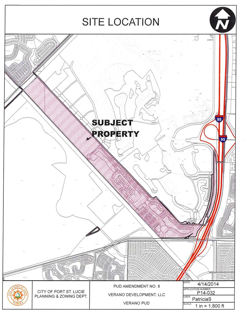
44 INTRODUCTION The comprehensive area of the Verano DRI (formerly known as the PGA Village/Montage DRI) is approximately 3,000 acres. It is to be located southwest of the existing PGA Village/Reserve, west of I- 95, and east of Glades Cut Off Road. The SFWMD C-24 Canal traverses directly through the northeastern section of the property. Verano as a whole is designed to include Multifamily and Single Family Residences with Championship Golf Courses, Commercial Development, Open Space, and Country Club amenities. The overall average density of the Verano DRI shall not exceed 2.2 du/ac. PUD 1 of Verano is to be a Single Family Residential development consisting of approximately 433 acres. Bordering the C-24 Canal to the south and the PGA Village/Reserve to the north, the proposed PUD 1 site can best be described as working citrus groves, with some areas at the east end being utilized as improved pasture. Although the average density for the Verano DRI as a whole shall not exceed 2.2 du/ac, PUD 1 is designed with a maximum residential density of 2.9 du/ac. The Verano DRI will include a variety of land uses including office commercial, retail commercial, residential single family, residential multifamily, light industrial, upland preserve, golf course and open space. PUD 1 is to be mainly residential with a Sales/Design Center and Construction Administration Building and with a 9.12 ac commercial/office/restaurant parcel along Commerce Center Drive South. The residential component will be single-family detached lots and single family attached villas. Verano PUD 1 will be supplied with water and wastewater services by the City of Port St. Lucie Utilities Department and will comply with all applicable City Ordinances, Policies, Specifications, and Regulatory Agencies governing such service. Wastewater services will be provided by the Glades Wastewater Treatment Plant upon completion and startup. By utilizing a combination of the various available service options to meet the wastewater needs at each phase of development, sufficient service will be available from these entities for the entire proposed development. Access to the Verano PUD 1 will be provided via Commerce Centre Drive South, a 120ft wide right-of- way traversing through the PGA Village/Reserve to be constructed in conjunction with this PUD and it shall be completed from its existing terminus in the PGA Village/Reserve, south to the future Crosstown Parkway right-of-way prior to the issuance of the first Certificate of Occupancy for PUD 1. Portions of Crosstown Parkway from the Commerce Centre Drive South intersection to the south right- of-way of the SFWMD C-24 canal will be completed in accordance with the Development Order concurrent with the construction of the Crosstown Parkway /I-95 interchange and will be completed prior to the opening of the interchange. This includes the construction of the bridge across the C-24 canal. The current plans are anticipating begin construction in August 2007 and completion of the bridge in April The internal future bridge shown on the master plan will be part of the approval process for the next phase south of the C-24 canal. An emergency access to Saddlebrook Drive in the PGA Village/Reserve is proposed per the request of the St. Lucie County Fire District. 7
45 Storm Water Management will be provided by an on-site system of lakes, currently under review by the South Florida Water Management District (SFWMD). A Conceptual Environmental Resource Permit (ERP) has been issued for the proposed project from South Florida Water Management District (SFWMD). The permit number is S. A conceptual drainage design was included as part of the application. Although PUD1 does not contain significant upland preserve, all upland preservation, recreation, and open space requirements of the PUD will be met within the comprehensive Verano DRI requirements. 8

46 9
47 EXHIBIT 2 P.U.D. APPLICATION CHECKLIST 1. Statement of Unified Control of the entire area within the proposed P.U.D. is enclosed as Exhibit Please see written statement setting forth proposed changes. 3. The Conceptual Plan for Verano PUD1 is enclosed as Exhibit 8 of this submittal package. 4. Please see Exhibit 6 for the proposed Development Uses / Standards established for this Planned Unit Development. The maximum building heights, minimum setbacks and other site data are shown in Exhibit 6 and Exhibit This community is part of the Verano D.R.I. approval. 10
48
49 Verano PUD 1 PUD Amendment 8 February 19, 2014 John Finizio City of Port St. Lucie 121 SW Port St. Lucie Blvd. Port St. Lucie, FL RE: PUD Concept Plan Amendment for Verano Development Amendment 8. Dear John: Cotleur & Hearing is pleased to present this cover letter and the associated material supporting our application to revise the Conceptual Master Plan for Verano PUD 1. A revision to this conceptual masterplan is necessary to accommodate Verano Development LLC s desire to modify the minimum width of single family lots. Verano is also proposing a re-configuration of the Rightof-Way, Lakes, Residential Area and Open Space for future phases of the development. There is no residential net loss or gain by these revisions and therefore the overall density of the project will remain unchanged. We are also updating the DRI development program table on the conceptual masterplan to be consistent with the NOPC. We have enclosed 22 sets of the proposed Conceptual Plan and PUD amendment 8 document for the Verano PUD, along with the required application materials and fee for your review and distribution to the Site Plan Review Committee. Please let me know if you have any questions on this Conceptual Site Plan review. Sincerely, Daniel T. Sorrow, AICP, ASLA, LEED AP BD+C Project Manager cc: cc: Bob Lawson, Arcadis Robert Fromm, Verano Development LLC 12
50 EXHIBIT 4 13
51 EXHIBIT 5 SITE INFORMATION Existing Proposed Change Recommendation Land Use Designation RGC/CG/LI RGC/CG/LI LI None Existing Zoning PUD PUD None Proposed Zoning PUD PUD None Total Area ac ac None Total Dwelling 1,200 1,200 None Units Single Family 650 Min 650 Min None Villas 550 Max 550 Max None Density.36 du/ac.36 du/ac None Residential Area 172 ac 39.73% ac 38.36% (-) 5.93 ac 1.37% Recreation 7.88 ac 7.88 ac None 1.91 % 1.91 % Commercial/Office ac ac None R/W Open Space FPL Lakes 2.92% ac 17.80% ac 11.75% ac 7.96% ac 19.13% 2.92% ac 17.00% ac 11.35% ac 7.96% ac 20.59% (+) % (+) % None (+) % Notes: (1) Existing Site Data is based on all approved changes from Amendment No 67 (P10-071) P13-010) 14
52 1. TOTAL ACREAGE: acres A. Residential acres B. Open Space acres C. Water Management Tracts acres D. Road Right-Of-Ways acres E. Commercial/Office acres F. Clubhouse/Recreation 7.88 acres G. FPL Buffer acres Totals acres 2. ALLOWABLE DENSTY 2.2 du./ac Max. Density (For overall Verano DRI) 3. PROPOSED DENSITY 2.9 du./ac Proposed Density 4. UPLAND PRESERVATION As indicated in the Verano DRI 5. MODEL AREA See Exhibit 8 for location of Model Areas 6. COMMERCIAL/OFFICE General Commercial, Retail, Hotel, Office and Restaurant including Construction Administration Building, Sales Center and Design Center 7. PEDESTRIAN WAYS The system of pedestrian movement will consist of sidewalks adjacent to streets within the residential neighborhoods as well as a pathway along the C-24 Canal as exhibited on Exhibit 8 & 11 Note: Verano PUD 1 is part of the Verano DRI with regards to maximum building coverage, open space and upland preservation requirements The acreage breakdown provided is conceptual and subject to adjustments during the platting process. 15
53 EXHIBIT 6 PROPOSED DEVELOPMENT USE/STANDARDS 1. PERMITTED PRINCIPAL USES A. RGC (Residential/ Golf Course) LAND USE AREA: 1. Single Family Detached Residences, Villas (Duplex subdivided on individual lots) 2. Temporary Construction Trailers 3. Model Homes 4. Lakes, 5. Recreation Facility and Maintenance Facility 6. Entry Gates and Guard House. 7. Golf Course (18 holes minimum) 8. Hotel (as defined in PGA/Verano DRI) 9. Retail (as defined in PGA/Verano DRI) 10. Conference Center* 11. Institutional (as defined in PGA Village/Verano DRI) 12. Temporary Sales and Design Center on lots Note: Non-residential uses shall be consistent with the provision of Policy of the City of Port St. Lucie Comprehensive Plan B. CG (Commercial General) LAND USE AREA: Permitted, Accessory and Special Exception Uses in the CG (Commercial General) Future Land Use Area are as provided for in Section of the City of Port St. Lucie Code of Ordinances. C. LI (Light Industrial) LAND USE AREA: Permitted, Accessory and Special Exception Uses in the LI (Light Industrial) Future Land Use Area are prohibited, except as provided for below. SPECIAL EXCEPTION USES: 1. Billboard 2. DENSITY: 2.9 du/ac. 16
54 3. PARKING REQUIRED: RGC Land Use: Two (2) parking spaces per residential unit and guest parking. All units shall have at least 2-car garages. At least two exterior parking spaces in the driveway shall be provided for each unit for residents and guests. 1 space/200 square feet of Recreation Facility/Clubhouse CG Land Use: 1space/200 square feet of Sales/Design Center and Construction Administration, Office and Retail All restaurants will provide 1 parking space per 200 gross square feet of building. 4. STREET DESIGN: Corner radii of intersecting street shall be a minimum of twenty five (25) feet. 5. MAXIMUM BLDG HEIGHT: Maximum height of residential structures shall not exceed thirty-five (35) feet above grade. Maximum height of non-residential structures shall not exceed 75 for parcels larger than 5 acres or 50 for parcels less than 5 acres. Architectural embellishments can exceed height by 25%. 6. MINIMUM LOT SIZES: Single Family Min. Width: feet Max. Width: 100 feet Min. Depth: 125 feet Max. Depth: 155 feet (See Exhibit 11 Typical Lots) Villas Min. Width: 40 feet Min. Depth: 70 feet (See Exhibit 11 Typical Lots) 7. MAXIMUM BUILDING COVERAGE: For Whole DRI: 30% Residential: 60% Commercial/Office: 35% 8. MAXIMUM IMPERVIOUS COVERAGE: For Whole DRI: 50% Residential: 75% Commercial/Office: 75% 17
55 9. MINIMUM BLDG SETBACKS: (See Exhibit 11, Typical Lots) Single-family: Minimum setbacks shall be as stated below unless otherwise indicated. Roof overhangs are allowed to overhang into building setbacks but not more than 24. Front Yard: Each lot shall have a front yard with a building setback line of ten (10) feet for dwellings living area or a side entry garage, and of twenty (20) feet for dwellings to a front entry garage. Side Yards: Side Yards apply to building and Accessory uses. Each lot shall have a setback of six (6) feet. A side yard of ten (10) feet shall be provided adjacent to right-of-ways. A side setback of 0 feet shall be allowed provided that a minimum building separation of 12 feet is maintained between units. The zero foot setback shall not be placed so that a building is closer than 10 feet to a right-of-way. Rear Yard: Each lot shall have a rear yard with a building setback line of fifteen (15) feet. There shall be 3 ft. setback requirements for the following accessory uses: Patios and Screen Enclosures and pools. Villas: Minimum setbacks shall be as stated below unless otherwise indicated. Roof overhangs are allowed to overhang into building setbacks. Front Yard: Each lot shall have a front yard with a building setback line of fifteen (15) feet to the building, ten feet (10) to the front porch and of twenty (20) feet to the front entry garage. Side Yards, Villa Type A: Side Yards apply to building and Accessory uses. Each lot shall have a setback of six (6) feet. A side yard of ten (10) feet shall be provided adjacent to right-of-ways. Side Yards, Villa Type B: Side Yards apply to building and Accessory uses. Each lot shall have a setback of nine (9) feet. A side yard of fifteen (15) feet shall be provided adjacent to right-of-ways. Rear Yard: Each lot shall have a rear yard with a building setback line of ten (10) feet. There shall be 5 ft. setback requirements for the following accessory uses: Hot Tubs, Patios and Screen Enclosures. Commercial/Office: Minimum setbacks shall be as stated below unless otherwise indicated. Roof overhangs are allowed to overhang into building setbacks. Front Yard: The front setback shall be twenty-five (25) feet from the right-of-way line. 18
56 Side Yards: Ten (10) feet from the property line, twenty-five (25) feet from the right-of-way or residential property line. Rear Yard: Ten (10) feet from the property line, twenty (20) feet from the right-of-way or residential property line. 10. FENCES / WALLS: Single Family: Fences and walls may be located along the rear and side property line, but they shall not extend past front building line. Maximum height shall be seven (7) feet. A decorative fence with a maximum height of three (3) feet shall be allowed along the front and side property line up to the front edge of the building as approved by the Property Owners Association. Villas: Fences, walls and /or privacy landscaping for Type A Villas shall be required and installed and maintained in kind by the Property Owners Association as shown on Exhibit 11. Fences and walls for Type B Villas may be located along the rear and side property line, but they shall not extend past front building line. Maximum height shall be seven (7) feet. A decorative fence with a maximum height of three (3) feet shall be allowed along the front and side property line up to the front edge of the building as approved by the Home Owners Association. 11. ACCESSORY USES: Accessory Uses/Structures are permitted in connection with any principle use provided that all accessory structures or uses are in full compliance with all setback, height, building coverage, and other requirements, or as restricted within the Property Owners Association documents. Approved uses are patios, outdoor cooking areas, gazebos and screen enclosures or as listed in the Property Owners Association Documents. Boats RV s and similar trailers are not allowed to be parked on site. 12. LANDSCAPING: Overall: No more than 25% of the required trees may be palm trees. A minimum of 25% of all required trees shall be native species. Landscaping shall meet the city s requirement for xeriscaping. Easement and Utility Area Landscaping: All trees may be planted within five (5) feet of any existing utility pole, guy wire, and pad mounted transformer. No protective barriers will be required. Commercial/Recreation/CommonOpen Space: The developer may utilize additional plant species that are not listed in the City s landscape code upon approval by the Site Plan Review committee. Shrub spacing shall be based on the growth 19
57 characteristics of the species and may exceed 24 inches on center. Landscape Buffer Strips: No wall shall be required adjacent to open space land unless it is Open Space Conservation. Single Family: Lots less than 6,000 sf shall provide two (2) trees Lots from 6,000 to 7,500 sf shall provide three (3) trees Lots over 7,500 sf shall provide four (4) trees Trees to be placed in the front yard may be substituted with street trees to be planted within the right-of- way in front of unit. Street trees will be planted at time units are being built. Villas: Villas are to be landscaped as shown on Exhibit 12. A list of species to be planted as part of the required landscaping is included on Exhibit 12. Buffers: A twenty (20) foot minimum buffer is proposed behind units directly abutting to residential units within neighboring property (Sabal Creek Area of the Reserve). This buffer shall contain a seven (7) foot wall or fence. In addition, a hedge shall be planted along the outside and inside of the wall as well as one (1) canopy tree per forty (40) linear feet of buffer, to be installed on the inside of the wall. A fifty (50) foot buffer is proposed for residential development areas abutting Commerce Center Drive. This buffer may contain an earthen berm with up to a seven (7) foot wall on top. The overall height combination between berm and wall shall not exceed 13 feet. There shall be landscaping on both sides of the berm and/or wall. In addition, at a minimum, a hedge or other suitable shrub vegetation shall be planted along the outside and inside of the wall as well as one (1) canopy tree per forty (40) linear feet of buffer. No landscape buffer is proposed behind units along the northern PUD boundary abutting directly on the adjacent golf course in the Reserve to allow for full utilization of the golf course views. Street Trees: Street trees shall be provided on a basis of one (1) tree per forty (40) linear feet of roadway per side. Tree spacing can be adjusted as necessary but shall not exceed fifty (50) feet on center as per city landscape code. Street trees planted in front of residential lots may be counted towards the canopy tree requirements for the lot. The street trees provided are in excess of the minimum requirement of 1 tree per fifty linear feet. This provides for enough additional trees to compensate for trees counted toward the canopy tree requirements for the lots. 13. CLUBHOUSE/RECREATION: Permitted Uses: Pool, Hot Tub, Cabana, Conference Facilities, Health Club, Outdoor Sports Facilities, Tot lot, Passive Garden Area, Golf Cart Parking Spaces. 20
58 14. FACADES: No two same facades shall be adjacent to each other. This does not apply to facades across the street. 15. FPL EASEMENT: If the orange grove is removed, FPL approved native plants will be used to replant the easement. Plant species to be in accordance with FPL Publications Plant the Right Tree in the Right Place. Plants will be added at a rate of 5 plants (shrubs, grasses or other native groundcovers or trees) per 100 square feet, of which 30% will be trees, 40 % will be shrubs and 30% will be grasses and groundcovers (which includes herbaceous native plants. If the whole area is cleared, a minimum of 40,000 plants will be planted. All plant materials will be saplings and bare root materials, as is customary with reforestation efforts with the exception of 5% of the trees, which will be of 8 height. Minimum height of grasses and groundcovers to be 4 inches, shrubs to the 6 inches and sapling trees shall range between 8 inches and 24 inches in height. The planting area will receive temporary irrigation through the establishment period of 12 month only. All landscape plans and location and species of trees and shrubs to the approved by FPL prior to installation. If orange trees are to be retained, they shall be maintained and the grass mowed. Diseased or withered trees shall be removed. All landscape plans are required to receive Site Plan Review Committee approval. 16. UTILITIES: All construction shall be in accordance with the City of Port St. Lucie Utility Systems Department s Technical Specifications and Construction Standards, latest revision, an with all applicable Florida Department of Environmental Protection rules and regulations. The Verano PUD acknowledges that the City may require reuse water be utilized for irrigation, equal to the amount of wastewater generated by the PUD, upon availability to the site. No intrusive root systems vegetation shall be placed within ten feet of utilities. All utilities shall be placed underground. Trees shall not be planted within 10 feet of any pslusd mains or appurtenances. All other utilities shall be a minimum of 5' horizontal separation from city utility mains for parallel installations and a minimum of 18" below city utility mains (all measurements are from outside to outside). No landscaping shall be placed in a manner that would create conflicts with the intended operation and maintenance of any existing or proposed water/wasterwater utility lines. Berms and structural landscape features such as rock, foundations, sculpture, decorative Wall and tree wells and generally not allowed in pslusd easements, but may be reviewed on a case by case basis. All measurements are from outside to outside, not centerline to centerline. Example: outside of pipe to nearest point on tree trunk. 21
59 No landscaping other than sod grasses may be planted within a 5' radius maintenance area of any pslsud appurtenance such as water meters, backflow devices, fire hydrants, sanitary sewer cleanouts, and manholes, air release valves, etc. All landscaping within port St. Lucie utility systems department (pslusd) utility easements shall comply with pslusd technical specifications, policies, and codes. 17. LITTORAL ZONES: At a minimum, Littoral areas will occur typically only around the islands within the lakes and will typically be placed along 50% of the shoreline of the island. Each littoral shelf will be of at least of 8 width with a maximum of 4:1 slope to a depth of 2 feet. 18. CONDITIONS OF APPROVAL: a. Prior to the issuance of the 550 th building permit the developer will construct the emergency access connection from Verano to Calumet Court. b. Prior to the issuance of the 1050 th building permit the developer will construct the emergency access connection from Verano to Glades Cut-Off Road. 22
60 EXHIBIT 7a LEGAL DESCRIPTION A PARCEL OF LAND LYING IN SECTIONS 28, 29, 33, AND 34, TOWNSHIP 36 SOUTH, RANGE 39 EAST, ST. LUCIE COUNTY, FLORIDA, BEING MORE PARTICULARLY DESCRIBED AS FOLLOWS: BEGIN AT THE INTERSECTION OF THE SOUTHEASTERLY RIGHT-OF-WAY LINE OF THE FLORIDA EAST COAST RAILROAD AND THE NORTHEASTERLY RIGHT-OF-WAY LINE OF SOUTH FLORIDA WATER MANAGEMENT DISTRICT CANAL NO. C-24; THENCE N44 45'38"E, ALONG SAID SOUTHEASTERLY RIGHT-OF-WAY LINE, A DISTANCE OF 1, FEET TO THE SOUTHERLY LINE OF SABLE CREEK, PHASE II, AS RECORDED IN PLAT BOOK 24, PAGE 1, PUBLIC RECORDS OF ST. LUCIE COUNTY, FLORIDA; THENCE S43 34'29"E, ALONG SAID SOUTHERLY LINE OF SAID PLAT AND ALONG THE SOUTHERLY LINE OF SABLE CREEK, PHASE IV, AS RECORDED IN PLAT BOOK 24, PAGE 17, PUBLIC RECORDS OF ST. LUCIE COUNTY, FLORIDA, A DISTANCE OF 5, FEET; THENCE S43 09'01"E, ALONG THE SOUTHERLY LINE OF SAID SABLE CREEK, PHASE IV, A DISTANCE OF 1, FEET TO THE SOUTHEAST CORNER OF SAID SABLE CREEK, PHASE IV; THENCE N45 11'03"E, ALONG THE EAST LINE OF SAID SABLE CREEK, PHASE IV, A DISTANCE OF 0.99 FEET; THENCE S43 08'40"E A DISTANCE OF FEET; THENCE S43 09'00"E A DISTANCE OF FEET; THENCE S43 08'32"E A DISTANCE OF 3, FEET; THENCE S72 43'17"E A DISTANCE OF FEET TO THE NORTHWESTERLY LINE OF THAT CERTAIN PARCEL OF LAND DESCRIBED IN SPECIAL WARRANTY DEED AS RECORDED IN OFFICIAL RECORDS BOOK 1577, PAGE 1222, PUBLIC RECORDS OF ST. LUCIE COUNTY, FLORIDA; THENCE N61 51'31"E, ALONG SAID NORTHWESTERLY LINE, A DISTANCE OF FEET; THENCE S43 08'30"E A DISTANCE OF 2, FEET TO THE NORTH LINE OF THAT CERTAIN PARCEL OF LAND DESCRIBED IN OFFICIAL RECORDS BOOK 1547, PAGE 490, PUBLIC RECORDS OF ST. LUCIE COUNTY, FLORIDA; THENCE N89 52'17"E, ALONG SAID NORTH LINE, A DISTANCE OF 1, FEET; THENCE S43 07'40"W A DISTANCE OF FEET; THENCE S46 52'20"E A DISTANCE OF FEET; THENCE S43 07'40"W A DISTANCE OF FEET TO THE BEGINNING OF A CURVE CONCAVE TO THE SOUTHEAST HAVING A RADIUS OF 1, FEET; THENCE SOUTHWESTERLY ALONG THE ARC OF SAID CURVE A DISTANCE OF FEET THROUGH A CENTRAL ANGLE OF 11 22'13"; THENCE S42 11'23"W A DISTANCE OF FEET TO THE INTERSECTION WITH A NON TANGENT CURVE CONCAVE TO THE EAST, HAVING A RADIUS OF 1, FEET, THE CHORD OF WHICH BEARS S20 45'38"W; THENCE SOUTHERLY ALONG THE ARC OF SAID CURVE, A DISTANCE OF FEET THROUGH A CENTRAL ANGLE OF 12 21'44"; THENCE S14 34'46"W A DISTANCE OF FEET; THENCE S53 16'05"W A DISTANCE OF FEET TO THE INTERSECTION WITH A NON TANGENT CURVE CONCAVE TO THE SOUTH, HAVING A RADIUS OF 11, FEET, THE CHORD OF WHICH BEARS N89 03'35"W; THENCE WESTERLY ALONG THE ARC OF SAID CURVE, A DISTANCE OF FEET THROUGH A CENTRAL ANGLE OF 02 01'59"; THENCE S81 39'48"W A DISTANCE OF FEET TO THE INTERSECTION WITH A NON TANGENT CURVE CONCAVE TO THE NORTH, HAVING A RADIUS OF 11, FEET, THE CHORD OF WHICH BEARS N88 40'44"W; THENCE WESTERLY ALONG THE ARC OF SAID CURVE, A DISTANCE OF 1, FEET THROUGH A CENTRAL ANGLE OF 05 28'51" TO THE POINT OF REVERSE CURVATURE WITH A CURVE CONCAVE TO THE SOUTH, HAVING A RADIUS OF 8, FEET; THENCE WESTERLY ALONG THE ARC OF SAID CURVE A DISTANCE OF FEET, THROUGH A CENTRAL ANGLE OF 23
61 01 17'51" TO THE NORTHEASTERLY RIGHT-OF-WAY LINE OF CANAL C-24; THENCE N43 08'36"W, ALONG SAID NORTHEASTERLY RIGHT-OF-WAY LINE, A DISTANCE OF 12, FEET TO THE POINT OF BEGINNING. CONTAINING ACRES, MORE OR LESS TOGETHER WITH: A PARCEL OF LAND LYING IN SECTIONS 26, 34, AND 35, TOWNSHIP 36 SOUTH, RANGE 39 EAST, ST. LUCIE COUNTY, FLORIDA, BEING MORE PARTICULARLY DESCRIBED AS FOLLOWS: COMMENCE AT THE NORTHEAST CORNER OF THE PLAT OF PGA COMMERCE CENTRE AT THE RESERVE, AS RECORDED IN PLAT BOOK 37, PAGES 6, 6A THRU 6C, PUBLIC RECORDS OF SAID ST. LUCIE COUNTY; THENCE N00 00'04"E AS A BASIS OF BEARINGS ALONG THE NORTHERLY PROLONGATION OF THE EASTERLY LINE OF SAID PLAT OF PGA COMMERCE CENTRE AT THE RESERVE, A DISTANCE OF FEET TO THE POINT OF BEGINNING OF THE FOLLOWING DESCRIBED PARCEL; SAID POINT ALSO BEING A POINT OF INTERSECTION WITH THE WESTERLY RIGHT-OF- WAY LINE OF STATE ROAD NO. 9 (I-95), AND A POINT OF INTERSECTION WITH A NON TANGENT CURVE CONCAVE TO THE WEST, HAVING A RADIUS OF 1, FEET, THE CHORD OF WHICH BEARS S19 21'15"E; THENCE TRAVERSING SAID WESTERLY RIGHT- OF-WAY LINE BY THE FOLLOWING NINE (9) COURSES AND DISTANCES: THENCE SOUTHERLY ALONG THE ARC OF SAID CURVE, A DISTANCE OF FEET THROUGH A CENTRAL ANGLE OF 09 02'54" TO THE POINT OF COMPOUND CURVATURE WITH A CURVE CONCAVE TO THE WEST, HAVING A RADIUS OF 2, FEET; THENCE SOUTHERLY ALONG THE ARC OF SAID CURVE, A DISTANCE FEET THROUGH A CENTRAL ANGLE OF 13 40'56"; THENCE S01 08'52"E A DISTANCE OF FEET; THENCE S00 00'04"W A DISTANCE OF 1, FEET TO THE INTERSECTION WITH A NON TANGENT CURVE CONCAVE TO THE WEST, HAVING A RADIUS OF 5, FEET, THE CHORD OF WHICH BEARS S12 50'28"W; THENCE SOUTHERLY ALONG THE ARC OF SAID CURVE, A DISTANCE OF 1, FEET THROUGH A CENTRAL ANGLE OF 15 19'51"; THENCE N69 29'03"W A DISTANCE OF FEET TO THE INTERSECTION WITH A NON TANGENT CURVE CONCAVE TO THE NORTHWEST, HAVING A RADIUS OF 1, FEET, THE CHORD OF WHICH BEARS S24 59'30"W; THENCE SOUTHWESTERLY ALONG THE ARC OF SAID CURVE, A DISTANCE OF FEET THROUGH A CENTRAL ANGLE OF 08 57'06"; THENCE N60 31'57"W A DISTANCE OF FEET TO THE INTERSECTION WITH A NON TANGENT CURVE CONCAVE TO THE NORTHWEST, HAVING A RADIUS OF 1, FEET, THE CHORD OF WHICH BEARS S30 29'59"W; THENCE SOUTHWESTERLY ALONG THE ARC OF SAID CURVE, A DISTANCE OF FEET THROUGH A CENTRAL ANGLE OF 02 03'51"; THENCE N40 32'39"W A DISTANCE OF FEET; THENCE S79 27'49"W A DISTANCE OF FEET; THENCE N10 32'10"W A DISTANCE OF FEET; THENCE N79 27'49"E A DISTANCE OF FEET; THENCE N19 28'17"E A DISTANCE OF FEET; THENCE N12 25'51"E A DISTANCE OF FEET; THENCE N04 50'19"E A DISTANCE OF FEET; THENCE N00 00'04"E A DISTANCE OF FEET TO THE SOUTHEAST CORNER OF SAID PLAT OF PGA COMMERCE CENTRE AT THE RESERVE; THENCE CONTINUE N00 00'04"E, ALONG THE EAST LINE OF SAID PLAT, A DISTANCE OF 1, FEET TO THE POINT OF BEGINNING. CONTAINING ACRES, MORE OR LESS. 24
62 EXHIBIT 7b WARRANTY DEEDS FOR PUD PROPERTY Go to Next Page 25
63 26
64 27
65 28
66 29
67 30
68 31
69 32
70 33
71 34
72 35
73 36
74 37
75 38
76 39
77 40
78 41
79 42
80 43
81 44
82 45
83 EXHIBIT 8 PUD CONCEPTUAL MASTER PLAN Go to Next Page 46
84 Land Use Designation Existing Proposed (+/_) Change Recommendation RGC/C G/LI RGC/CG/ LI Added LI Existing Zoning PUD PUD None Proposed Zoning PUD PUD None Total Area ac ac None ac Total Dwelling Units 1,200 1,200 None Single Family 650 Min. 650 Min. None Min. Villas 550 Max. 550 Max. None Max. Density 0.36 du/ac 0.36 du/ac None du/ac Residential Area Recreation 172 ac ac 5.93 ac (-) 39.73% 38.36% 1.37% 7.88 ac 7.88 ac ac None 1.91% 1.91% Commercial/Office ac ac ac None 2.92% 2.92% R/W Open Space FPL Lakes ac ac 1.38 ac (+) 17.80% 17.00% 0.32% ac ac 1.75 ac (-) 11.75% 11.35% 0.40% ac ac ac None 7.96% 7.96% ac ac 6.3 ac (+) 19.13% 20.59% 1.46% Land Use Proposed PUD 1 Remaining Total Residential 1,200 6,000 7,200 units Assisted Living units Recreational Vehicle Park spaces Hotel rooms Retail, Service 150, , ,500 SF 1 public golf courses, 60,000 ancillary golf facilities 1 public golf courses, 40,000 ancillary golf facilities 2 public golf courses, 100,000 ancillary golf facilities Recreation Office - 100, ,000 SF Institutional - 48 Acre School Site 48 Acre School Site
85 EXHIBIT 9 PHASING PLAN Go to Next Page 48
86
87 EXHIBIT 10 Typical Right -of- way Sections Go to Next Page 50
88 51
89 52
90 53
91 54
92 55
93 EXHIBIT 11 TYPICAL LOTS Go to Next Page 56
94 57
95 58

96 59
97 60
98 EXHIBIT 12 TYPICAL UNITS LANDSCAPE PLANS Go to Next Page 61

99 62
100 63
101 EXHIBIT 13 TRAFFIC STATEMENT Go to Next Page 64
102 To: From: Date: July 28, 2010 Subject: City of Port St. Lucie Planning Department Dennis J. Murphy, Principal Planner Traffic Statement for Phase 1 of the Verano Planned Unit Development area (formerly known as the Montage), City of Port St. Lucie. Florida The proposed Amendment #6 to the Verano Planned Unit Development (Phase 1) area (formerly known as the Montage), is for the purpose of clarifying the identification of potential commercial uses that may be allowed within the limits of the Commercially designated Future Land Use limits of this PUD. This change will not result in changes to the previously approved trip generation rates or the projected impacts as addressed through the approved Development of Regional Impact (DRI) known as Verano. The traffic impacts of this development were fully analyzed in the analysis included in the Application for Development Approval (ADA) for the DRI. The results of that analysis were used as the basis for the traffic conditions included in the Final Development Order for the Verano DRI. The maximum number of residential units included in this Phase I portion of the project remains at 1,200. The Commercial acreage remains at acres. As previously reported to the City, the trip generation potential for the 1,200 units, based on the trip generation projection included in the ADA Traffic analysis for build out of the DRI, is 9,063 total daily trips and 871 total PM peak-hour trips (557 inbound and 3 14 outbound). After internal capture with other uses within the DRI, phase 1 will generate 777 new external PM peak-hour trips (509 inbound and 268 outbound). The proposed Amendment #6 to the Verano Planned Unit Development (Phase 1) area (formerly known as the Montage), does not warrant any changes to the previously approved transportation related development orders/conditions. 65
103 EXHIBIT 14 DRAINAGE STATEMENT Go to Next Page 66
104 To: From: Date: July 28, 2010 Subject: City of Port St. Lucie Planning Department Dennis J. Murphy, Principal Planner Drainage Statement for Phase 1 of the Verano Planned Unit Development area (formerly known as the Montage), City of Port St. Lucie. Florida The proposed Amendment #6 to the Verano Planned Unit Development (Phase 1) area (formerly known as the Montage), is for the purpose of clarifying the identification of potential commercial uses that may be allowed within the limits of the Commercially designated Future Land Use limits of this PUD. This change will not result in changes to the previously approved site drainage designs. 67
105
 Villa Vizcaya PUD Amendment No. 3 4 April 16, 2008 May 29, 2015 Presented to: City of Port St. Lucie Planning and Zoning Department 121 SW Port St. Lucie Boulevard Port St. Lucie, Florida 34984 Exhibit
EXHIBIT B PROJECT NARRATIVE POULSBO MEADOWS
 EXHIBIT B PROJECT NARRATIVE POULSBO MEADOWS Name of Project: Poulsbo Meadows; A Planned Residential Development (PRD)/Plat Applicants Name: PBH Group LLC/Byron Harris PO Box 1010 Silverdale, WA 98038 Description
CITY PLANNING COMMISSION AGENDA ITEMS: C.1, C.2 STAFF: MEGGAN HERINGTON FILE NO(S): CPC PUZ QUASI-JUDICIAL CPC PUD QUASI-JUDICIAL
: CPC PUZ QUASI-JUDICIAL CPC PUD QUASI-JUDICIAL") Page 32 CITY PLANNING COMMISSION AGENDA ITEMS: C.1, C.2 STAFF: MEGGAN HERINGTON FILE NO(S): CPC PUZ 13-00036 QUASI-JUDICIAL CPC PUD 13-00037 QUASI-JUDICIAL PROJECT: APPLICANT: OWNER: ESTANCIA AT CORDERA
Page 32 CITY PLANNING COMMISSION AGENDA ITEMS: C.1, C.2 STAFF: MEGGAN HERINGTON FILE NO(S): CPC PUZ 13-00036 QUASI-JUDICIAL CPC PUD 13-00037 QUASI-JUDICIAL PROJECT: APPLICANT: OWNER: ESTANCIA AT CORDERA
PLANNED UNIT DEVELOPMENT & SUBDIVISION STAFF REPORT Date: May 18, 2017
 & PUD-0000102-2017 PLANNED UNIT DEVELOPMENT & SUBDIVISION STAFF REPORT Date: May 18, 2017 NAME SUBDIVISION NAME Dauphin Creek Estates Subdivision Dauphin Creek Estates Subdivision LOCATION CITY COUNCIL
SITE PLAN REVIEW APPLICATION AND CHECKLIST
 SITE PLAN REVIEW APPLICATION AND CHECKLIST PROJECT SUMMARY: Project Name: City/ETA Location: City ETA (Application fee & number of copies needed are based on location) Property Location (Legal Description
Verano Talavera Clubhouse Port St. Lucie, Florida
 Landscape Architects I Land Planners I Environmental Consultants 1934 Commerce Lane Suite 1 Jupiter, Florida 33458 Ph 561.747.6336 Fax 561.747.1377 www.cotleurhearing.com Lic # LC-C000239 Verano Talavera
 701 E Ocean Blvd., Stuart, Florida 34994 100 Avenue A Suite 2A, Fort Pierce, Florida 34950 827 North Thornton Avenue, Orlando, Florida 32803 (772) 220-2100, Fax (772) 223-0220 (772) 467-1301, Fax (772)
Site Development Plan (SDP) Checklist
 Checklist") Development Services Department 100 N. Wilcox Street, Castle Rock CO 80104 303-660-1393 or CRGov.com Site Development Plan (SDP) Checklist A complete Site Development Plan (SDP) submittal will contain
Development Services Department 100 N. Wilcox Street, Castle Rock CO 80104 303-660-1393 or CRGov.com Site Development Plan (SDP) Checklist A complete Site Development Plan (SDP) submittal will contain
ARTICLE II. LANDSCAPING
 ARTICLE II. LANDSCAPING Sec. 35-31. Landscaping required for all site development. (a) Residential Developments: (1) All residential lots shall provide a minimum of one (1) boulevard tree (planted between
CITY OF DEERFIELD BEACH Request for City Commission Agenda
 Item: CITY OF DEERFIELD BEACH Request for City Commission Agenda Agenda Date Requested: April 2, 2013 Contact Person: Gerald R. Ferguson, Director of Planning & Development Services Description: 3317,
REQUEST FOR COUNCIL ACTION 6A AGENDA ITEM
 DATE REQUEST FOR COUNCIL ACTION 6A AGENDA ITEM ORIGINATING DEPT. AGENDA ITEM CITY ADMINISTRATOR APPROVAL Community Development PUD Concept & Development Stage Plan Preliminary Plat & Final Plat PREVIOUS
SUBMITTAL REQUIREMENTS
 WHEN PROCESS TYPE III IS USED References to Process Type III applications are found in several places in the Milton Municipal Code (MMC), indicating that the development, activity, or use, is permitted
CITY OF ZEELAND PLANNING COMMISSION
 APPLICATION FOR SITE PLAN REVIEW AND SPECIAL LAND USE Date City Official App. Filing Fee Rec'd ($350) NOTE TO APPLICANT: Please submit this application for Site Plan Review along with twenty (20) copies
PLANNED UNIT DEVELOPMENT Date: April 5, 2018
 PLANNED UNIT DEVELOPMENT Date: April 5, 2018 DEVELOPMENT NAME SUBDIVISION NAME LOCATION Robert Myers Robert Myers 2955 and 2989 Dauphin Street (Southeast corner of Dauphin Street and Sage Avenue) CITY
ARTICLE VII OVERLAY DISTRICTS AND AREAS
 ARTICLE VII OVERLAY DISTRICTS Section 7.1 Special Overlay Districts Special Overlay Districts may be created by the City of Mascotte to facilitate unique development activities where there is need for
Landscape and fencing requirements of this Chapter shall apply to all new landscaped areas.
 Chapter 19.06. Landscaping and Fencing. Sections: 19.06.01. Purpose. 19.06.02. Required Landscaping Improvements. 19.06.03. General Provisions. 19.06.04. Landscaping Plan. 19.06.05. Completion of Landscape
PART XVI - R-H(G) HALF-ACRE RESIDENTIAL - GROSS DENSITY ZONE A. INTENT
 HALF-ACRE RESIDENTIAL - GROSS DENSITY ZONE A. INTENT") PART XVI - R-H(G) HALF-ACRE RESIDENTIAL - GROSS DENSITY ZONE PART XVI - R-H(G) HALF-ACRE RESIDENTIAL - GROSS DENSITY ZONE A. INTENT This zone is intended for single family housing on suburban Amended lots,
PART XVI - R-H(G) HALF-ACRE RESIDENTIAL - GROSS DENSITY ZONE PART XVI - R-H(G) HALF-ACRE RESIDENTIAL - GROSS DENSITY ZONE A. INTENT This zone is intended for single family housing on suburban Amended lots,
KASPER. City of Georgetown, Texas PUD Planned Unit Development. December 30, 2015 Revised January 27, 2016
 KASPER City of Georgetown, Texas PUD Planned Unit Development December 30, 2015 Revised January 27, 2016 Applicant: Sentinel Land Company, LLC 4910 Campus Drive Newport Beach, CA Prepared by: SEC Planning
EAST LAKE TARPON COMMUNITY OVERLAY
 EAST LAKE TARPON COMMUNITY OVERLAY East Lake Tarpon in Pinellas County Florida physical area is defined by the boundaries of the as shown in the map below and legal description in Appendix A. VISION: East
PLANNED UNIT DEVELOPMENT APPLICATION
 PLANNED UNIT DEVELOPMENT APPLICATION CITY OF THE DALLES Community Development Department 313 Court Street The Dalles, OR 97058 (541) 296-5481, ext. 1125 Fax (541) 298-5490 www.ci.the-dalles.or.us Date
 NOTES: 1.) THE BOGGY CREEK RD. AND SIMPSON RD. IMPROVEMENTS DEPICTED ON THIS PLAN ARE BASED ON RECORD CONSTRUCTION PLANS AND HAVE NOT BEEN SURVEYED. 2.) EXISTING RESIDENTIAL BUILDING STRUCTURES AND ANCILLARY
Baumgarten MPUD. Exhibit 3 Evaluation Criteria
 Pursuant to LDC subsections 10.02.13 B, 10.02.08 F and Chapter 3 G. of the Administrative Code, staff s analysis and recommendation to the Planning Commission, and the Planning Commission s recommendation
ORDINANCE Underline: Additions to Ordinance Strike-through: Deleted Text from Existing Ordinance
 AN ORDINANCE OF INDIAN RIVER COUNTY, FLORIDA CONCERNING AMENDMENTS TO LAND DEVELOPMENT REGULATIONS (LDRS); PROVIDING FINDINGS; PROVIDING FOR AMENDMENTS TO CHAPTER, 901, DEFINITIONS; CHAPTER 911, ZONING;
LANDSCAPE ORDINANCE PASADENA PLANNING DEPARTMENT (713) FAX (713)
 FAX (713)") LANDSCAPE ORDINANCE PASADENA PLANNING DEPARTMENT (713) 475-5543 FAX (713) 477-1072 ARTICLE X. LANDSCAPING OF NONRESIDENTIAL SITES* Sec. 9-195. Applicability. (a) This article shall apply to the following:
LANDSCAPE ORDINANCE PASADENA PLANNING DEPARTMENT (713) 475-5543 FAX (713) 477-1072 ARTICLE X. LANDSCAPING OF NONRESIDENTIAL SITES* Sec. 9-195. Applicability. (a) This article shall apply to the following:
AGENDA ITEM NO. 17. Interim City Manager: Arnold Shadbehr Dir. Of Planning: Brian James
 AGENDA ITEM NO. 17 CITY OF HAWTHORNE CITY COUNCIL AGENDA BILL For the meeting of October 23, 2018 Originating Department: Planning and Community Development Interim City Manager: Arnold Shadbehr Dir. Of
November 21, Planning Commission Charter Township of Lyon Grand River Ave. New Hudson, MI 48165
 Planning Commission Charter Township of Lyon 58000 Grand River Ave. New Hudson, MI 48165 Subject: AP-18-68; 11 Mile and Milford Road Park, Site Plan Review #1 Based on site plan dated 11/12/18 Location:
BUFFERS, TREE PROTECTION AND LANDSCAPING. Sec Purpose and Intent.
 ARTICLE 20 BUFFERS, TREE PROTECTION AND LANDSCAPING Sec. 20.1. Purpose and Intent. Trees improve air and water quality, reduce soil erosion, reduce noise and glare, provide habitat for desirable wildlife,
PRELIMINARY PLAT DESIGN REQUIREMENTS Updated 4/8/2016
 PRELIMINARY PLAT DESIGN REQUIREMENTS Updated 4/8/2016 The following items are required for the preliminary plat. Numbers correspond with those on the example preliminary plat. RENO COUNTY SUBDIVISION REQUIREMENTS
PART I. Adoption, Indiantown Redevelopment Overlay District. Section is hereby adopted to read as follows:
 PART I. Adoption, Indiantown Redevelopment Overlay District. Section 3.265 is hereby adopted to read as follows: Section 3.265. Indiantown Redevelopment Overlay District. A. Property Development Standards
PLANNED UNIT DEVELOPMENT & SUBDIVISION STAFF REPORT Date: March 15, 2012
 PLANNED UNIT DEVELOPMENT & SUBDIVISION STAFF REPORT Date: March 15, 2012 DEVELOPMENT NAME SUBDIVISION NAME LOCATION OSR Subdivision OSR Subdivision 5559 Old Shell Road (South side of Old Shell Road, 570
The subject site plan amendment proposes the following revisions to the approved site plan:
 PROPOSED AMENDMENT The subject site plan amendment proposes the following revisions to the approved site plan: 1. The building footprint was modified to accommodate the revised architectural design. 2.
CASE NUMBER: 16SN0701 APPLICANT: Hanky, LLC
 STAFF S ANALYSIS AND RECOMMENDATION Planning Commission (CPC) Public Hearing Date: MAY 17, 2016 CPC Time Remaining: 100 DAYS Applicant s Agent: DANIEL L. CASKIE (804-569-7060) Applicant s Contact: MICHAEL
 PROJECT NARRATIVE AVENIR PCD SITE PLAN #2 SITE PLAN REVIEW March 14, 2018 Request Avenir Holdings, LLC, the owner of the approved Avenir Planned Urban Planning and Design Landscape Architecture Communication
ARTICLE IV: DEVELOPMENT STANDARDS 404 MASTER PLANNING
 IV 13 404 MASTER PLANNING Master Planning through the Site Analysis (Master Planning Site Analysis) or Planned Development (Master Planning Planned Development) is provided to encourage development which
EXHIBIT. PUD Written Description
 EXHIBIT D PUD Written Description Krispy Kreme at Merrill Road PUD Revised 09-30-2013 City Development Number: I. PROJECT DESCRIPTION The subject property identified as Real Estate No.120466 0030 on Panel
Mitchell Ranch South MPUD Application for Master Planned Unit Development Approval Project Narrative. Introduction
 Mitchell Ranch South MPUD Application for Master Planned Unit Development Approval Project Narrative Introduction Mitchell Ranch South is a proposed single family (detached) residential development on
Sanford/Lee County Technical Review Committee (TRC) DEADLINES & MEETING DATES
 DEADLINES & MEETING DATES") Sanford/Lee County Technical Review Committee (TRC) DEADLINES & MEETING DATES The following 2019 information is based on the information available to staff at the time of creation. Dates & time may change
Sanford/Lee County Technical Review Committee (TRC) DEADLINES & MEETING DATES The following 2019 information is based on the information available to staff at the time of creation. Dates & time may change
CITY OF KEIZER MASTER PLAN APPLICATION & INFORMATION SHEET
 CITY OF KEIZER MASTER PLAN APPLICATION & INFORMATION SHEET PRE-APPLICATION CONFERENCE Prior to the actual filing of a Master Plan application, it is strongly recommended that the applicant contact Planning
City of Yelm. Tahoma Terra Final Master Plan Development Guidelines. Table of Contents
 City of Yelm Tahoma Terra Final Master Plan Development Guidelines Table of Contents Table of Contents... 1 Purpose... 2 Low Density Residential (R4-6)... 3 Moderate Density Residential (R6-10)... 5 Neighborhood
General Location Courtyard at LMH Final Development Plan and Final Plat
 R-1 LEYDEN RIDGE LOMA RIDGE LOBDELL R-3 MILLER PARKWAY LAUSSAC Subject Property R-3 LOCHENSHIRE LESMER R General Location Courtyard at LMH Final Development Plan and Final Plat ¹ 230 115 0 230 Feet Airport
Rezoning Petition Pre-Hearing Staff Analysis May 21, 2018
 Rezoning Petition 2018-018 Pre-Hearing Staff Analysis May 21, 2018 REQUEST Current Zoning: R-5 (single family residential), R-5 HD-O (single family residential, historic district overlay) and B-2(CD) HD-O
4.500 Preston Road Overlay District
 Section 4.500 Preston Road Overlay District 2004 Zoning Ordinance 4.500 Preston Road Overlay District (ZC 98-29; Ordinance No. 98-9-12) 4.501 Purpose To provide appropriate design standards for the use
CONSENT CALENDAR CITY PLANNING COMMISSION AGENDA ITEM NO: A.1, A.2 STAFF: LARRY LARSEN
 Page 8 CONSENT CALENDAR CITY PLANNING COMMISSION AGENDA ITEM NO: A.1, A.2 STAFF: LARRY LARSEN FILE NO: CPC PUZ 14-00013 - QUASI-JUDICIAL FILE NO: CPC PUD 14-00014 QUASI-JUDICIAL PROJECT: APPLICANT: OWNER:
Project Narrative Proposed Hillcrest Country Club Property Redevelopment Final Site Plan Application July 6, 2015 Revised: October 30, 2015
 Planning, Site and Master Planning, Landscape Architecture, Due Diligence, Project Management 2135 Bellcrest Court Royal Palm Beach, Fl. 33411 561-707-3410 Introduction and proposed application Project
The petition proposes the development of five townhomes on a vacant parcel between Charlotte Latin School and Providence Presbyterian Church.
 Rezoning Petition 2017-202 Final Staff Analysis June 18, 2018 REQUEST LOCATION Current Zoning: R-3 (single family residential) Proposed Zoning: UR-2(CD) (urban residential, conditional) with five-year
REQUEST FOR COUNCIL ACTION 6A AGENDA ITEM ORIGINATING DEPT. AGENDA ITEM CITY ADMINISTRATOR APPROVAL
 DATE REQUEST FOR COUNCIL ACTION 6A AGENDA ITEM ORIGINATING DEPT. AGENDA ITEM CITY ADMINISTRATOR APPROVAL Community Development Territorial Greens PUD Concept Plan Development Stage Plan Subdivision (Preliminary
TOP TEN LIST OF COMMUNITY CONCERNS REGARDING PROPOSED AMENDMENTS TO CHAPTER 42
 TOP TEN LIST OF COMMUNITY CONCERNS REGARDING PROPOSED AMENDMENTS TO CHAPTER 42 1. Extend the urban area to Beltway 8 in stages, over say a three-year period, prioritizing development in transit and declining
DRAFT Subject to Modifications
 TREASURE COAST REGIONAL PLANNING COUNCIL M E M O R A N D U M To: Council Members AGENDA ITEM 5P From: Date: Subject: Staff February 20, 2009 Council Meeting Local Government Comprehensive Plan Review Draft
TOWN OF CARY. PARCEL INFORMATION Parcel # Realid # Area acres
 TOWN OF CARY Lochmere PUD Amendment -Greensview Tract 00-REZ-31 FINAL CONDITIONS APPLICANT(S) OWNER(S) OWNER(S) Preston Creative School, LLC c/o Mr. Jim Fauver 110 Preston Grande Way Morrisville, NC 27560
CITY PLANNING COMMISSION AGENDA ITEM: C STAFF: ROBERT TEGLER FILE NO: CPC PUD QUASI-JUDICIAL
 CPC AGENDA June 8, 2006 Page 37 CITY PLANNING COMMISSION AGENDA ITEM: C STAFF: ROBERT TEGLER FILE NO: CPC PUD 05-294 - QUASI-JUDICIAL PROJECT: APPLICANT: OWNER: PARKWOOD AT WOLF RANCH NASS DESIGN ASSOCIATES
OCEAN BOULEVARD PLANNED DEVELOPMENT DISTRICT (PD-5)
") OCEAN BOULEVARD PLANNED DEVELOPMENT DISTRICT (PD-5) Ordinance History: C-5562, 1982 The intent of the Planned Development Plan is to provide a framework to guide new development in a way that is sensitive
OCEAN BOULEVARD PLANNED DEVELOPMENT DISTRICT (PD-5) Ordinance History: C-5562, 1982 The intent of the Planned Development Plan is to provide a framework to guide new development in a way that is sensitive
Chapter RM MULTI FAMILY BUILDING ZONES
 Chapter 19.17 RM MULTI FAMILY BUILDING ZONES 19.17.010 Established 19.17.020 Primary Permitted Uses 19.17.030 Accessory Permitted Uses 19.17.040 Secondary Permitted Uses 19.17.050 Conditional Property
CITY COUNCIL STUDY SESSION MEMORANDUM
 City and County of Broomfield, Colorado CITY COUNCIL STUDY SESSION MEMORANDUM To: From: Prepared by: Mayor and City Council Charles Ozaki, City and County Manager Kevin Standbridge, Deputy City and County
Application Number: SD Project Name: Walton Farms Preliminary Subdivision (acting as Master Plan)
") STAFF REPORT Town of Clayton Planning Department 111 E. Second Street, Clayton, NC 27520 P.O. Box 879, Clayton, NC 27528 Phone: 919-553-5002 Fax: 919-553-1720 Planning Board May 22, 2017 Application Number:
STAFF REPORT Town of Clayton Planning Department 111 E. Second Street, Clayton, NC 27520 P.O. Box 879, Clayton, NC 27528 Phone: 919-553-5002 Fax: 919-553-1720 Planning Board May 22, 2017 Application Number:
ARTICLE 9: Landscaping
 ARTICLE 9: Landscaping 9-10 Legislative Intent The purpose of this Article is to regulate the planting and preservation of landscape materials; to facilitate the creation of an attractive and healthy environment;
PRELIMINARY CONDITIONAL USE SUBMITTAL CHECKLIST REQUIREMENTS
 This checklist must accompany your submittal as the cover page. CONDITIONAL USE Application Submittal Checklist for PRELIMINARY AND FINAL APPROVAL Per Winter Park Land Development Code Sec. 58-90 PRELIMINARY
CHAPTER ADDITIONAL REQUIREMENTS IN THE NC, NEIGHBORHOOD COMMERCIAL ZONE
 CITY OF MOSES LAKE MUNICIPAL CODE CHAPTER 18.31 ADDITIONAL REQUIREMENTS IN THE NC, NEIGHBORHOOD COMMERCIAL ZONE Sections: 18.31.010 Purpose 18.31.020 Minimum Lot Area 18.31.030 Setbacks 18.31.040 Maximum
RESIDENTIAL PLANNED UNIT DEVELOPMENT / SUBDIVISION AND REZONING CONCEPT AND DEVELOPMENT STAGE PLAN SUBMITTAL NARRATIVE
 RESIDENTIAL PLANNED UNIT DEVELOPMENT / SUBDIVISION AND REZONING CONCEPT AND DEVELOPMENT STAGE PLAN SUBMITTAL NARRATIVE DEVELOPMENT TEAM DONEGAL SOUTH Maple Grove, Minnesota March 27, 2017 Applicant/Developer/Builder:
BOULEVARD AND PARKWAY STANDARDS
 88-323 BOULEVARD AND PARKWAY STANDARDS 88-323-01 PURPOSE Considerable public and private investment exists and is expected to occur adjacent to boulevards and parkways within the city. The following standards
ORDINANCE NO
 ATTACHMENT CC-1 ORDINANCE NO. 13-2113 AN ORDINANCE OF THE CUPERTINO CITY COUNCIL APPROVING THE REZONING OF AN APPROXIMATELY 1.1 ACRE AREA FROM PARK AND RECREATION (PR) TO PLANNED INDUSTRIAL PARK (P(MP))
R E S O L U T I O N. Single-Family Residence/ Church. 2,488 sq. ft. 2,488 sq. ft. Area Parking Required: Church
 R E S O L U T I O N WHEREAS, the Prince George s County Planning Board is charged with the approval of Detailed Site Plans pursuant to Part 3, Division 9 of the Zoning Ordinance of the Prince George s
Environmental Protection Ordinances (Performance Zoning) Bedminster Township, Bucks County
 Bedminster Township, Bucks County") Environmental Protection Ordinances (Performance Zoning) Bedminster Township, Bucks County ARTICLE VI. PERFORMANCE STANDARDS Section 600 Compliance All uses, activities, subdivisions and/or land developments
Environmental Protection Ordinances (Performance Zoning) Bedminster Township, Bucks County ARTICLE VI. PERFORMANCE STANDARDS Section 600 Compliance All uses, activities, subdivisions and/or land developments
Application for Site Plan Review
 Application for Site Plan Review City of Pontiac Office of Land Use and Strategic Planning 47450 Woodward Ave, Pontiac, MI 48342 T: 248.758.2800 F: 248.758.2827 Property/Project Address: Sidwell Number:
SMALL LOT DESIGN STANDARDS. An Illustrated Working Draft for Test Implementation
 SMALL LOT DESIGN STANDARDS An Illustrated Working Draft for Test Implementation SMALL LOT DESIGN STANDARDS ILLUSTRATED WORKING FOR TEST IMPLEMENTATION OVERVIEW SMALL LOT CODE AMENDMENT & POLICY UPDATE
The Ritz-Carlton, Paradise Valley
 The Ritz-Carlton, Paradise Valley 7000 E. Lincoln Drive Keys to Success Community Conversation II June 4, 2015 RITZ-CARLTON PARADISE VALLEY Town Council Study Session June 4, 2015 General Plan 2012 Land
THE CITY OF MOBILE, ALABAMA
 THE CITY OF MOBILE, ALABAMA LETTER OF DECISION Ark of Safety, Inc. Mobile, AL 36617 Re: (Northwest corner of Main Street and First Avenue, extending to the Southwest corner of Esau Avenue and Main Street.)
Statement of Intent Proposed Development Five Forks Athletics Scuffletown Rd, Greenville SC
 Statement of Intent Proposed Development Five Forks Athletics Scuffletown Rd, Greenville SC Tax Map #0548020103205 1 P a g e Table of Contents Statement of Intent...page 3-9 Exhibit A Utility Letters Exhibit
PLANNING BOARD HEARING Miami Shores Village Town Hall Council Chambers NE 2 nd Avenue Miami Shores Workshop Date April 24, 2014
 MIAMI SHORES VILLAGE DEPARTMENT OF PLANNING & ZONING 10050 NE 2 nd Avenue Miami Shores FL 33037-2304 www.miamishoresvillage.com David A. Dacquisto AICP, Director dacquistod@miamishoresvillage.com Main
REZONING GUIDE. Zone Map Amendment (Rezoning) - Application. Rezoning Application Page 1 of 3. Return completed form to
 - Application. Rezoning Application Page 1 of 3. Return completed form to") Zone Map Amendment (Rezoning) - Application COMMUNITY PLANNING & DEVELOPMENT REZONING GUIDE Rezoning Application Page 1 of 3 PROPERTY OWNER INFORMATION* CHECK IF POINT OF CONTACT FOR APPLICATION Property
Zone Map Amendment (Rezoning) - Application COMMUNITY PLANNING & DEVELOPMENT REZONING GUIDE Rezoning Application Page 1 of 3 PROPERTY OWNER INFORMATION* CHECK IF POINT OF CONTACT FOR APPLICATION Property
Zoning:CS FLU: LI/CS 4, SF 10' HT 21,120 SF 24.5' HT Proposed Usable Open Space (120 SF) 4,774 SF 10' HT 4, SF 15.5' HT 4, SF 15.5'
 4,774 SF 10' HT 4, SF 15.5' HT 4, SF 15.5'") Zoning:CS FLU: LI/CS 4,709.21 SF 21,120 SF 24.5' HT Proposed Usable Open Space (120 SF) 4,774 SF 4,014.01 SF 15.5' HT 4,655.61 SF 15.5' HT Proposed Bike Rack RAMP Proposed 3" Concrete Ballard BUILDING
Zoning:CS FLU: LI/CS 4,709.21 SF 21,120 SF 24.5' HT Proposed Usable Open Space (120 SF) 4,774 SF 4,014.01 SF 15.5' HT 4,655.61 SF 15.5' HT Proposed Bike Rack RAMP Proposed 3" Concrete Ballard BUILDING
PART I-D BUFFERS AND LANDSCAPING REQUIREMENTS
 District Regulations Of General Applicability ARTICLE IX PART I-D BUFFERS AND LANDSCAPING REQUIREMENTS 9-107 BUFFERS AND LANDSCAPING 9-107 A. General Landscaping and Maintenance Requirements. Except for
that the Town Board of the Town of East Greenbush will hold a public hearing on April 11,
 TOWN OF EAST GREENBUSH NOTICE OF PUBLIC HEARING PLEASE TAKE NOTICE that the Town Board of the Town of East Greenbush will hold a public hearing on April 11, 2018, at 5:45 p.m. at the East Greenbush Town
Narcoossee Roadway Corridor
 Community Meeting Narcoossee Roadway Corridor April 5, 2012 Meeting Agenda Purpose of Meeting Continuation of Study Update Process (Previous Meetings Oct. & Nov., 2011) Tonight s Objective Review Proposals
SITE PLAN REVIEW ITEMS - REFERENCE CHECKLIST
 City of Seminole 9199 113 th Street N. Seminole, FL 33772 Ph: (727) 392-1966 Fx: (727) 319-6583 SITE PLAN REVIEW ITEMS - REFERENCE CHECKLIST Note: This checklist is designed to aid designers in the review
Re: Thorncreek Commons Commercial Response to Pre-Application Meeting held September 24, 2014 Comments
 8/20/2015 Jay Ruchti Senior Planner City Development Department City of Thornton 9500 Civic Center Drive Thornton, CO Re: Thorncreek Commons Commercial Response to Pre-Application Meeting held September
City of Placerville Planning Commission AGENDA REPORT ITEM 7
 Placerville, a Unique Historical Past Forging into a Golden Future City of Placerville Planning Commission REPORT ITEM 7 MEETING DATE: September 1, 2015 APPLICATION NO: 225 Placerville Drive Site Plan
SPECIFIC PLAN Requirements
 CITY OF LANCASTER PLANNING DEPARTMENT 44933 Fern Avenue, Lancaster, California 93534 (661) 723-6100 SPECIFIC PLAN Requirements Purpose The purpose of a specific plan is to provide for the logical development
Master Land Use Plan Application
 Development Review Division Development Services Department CITY OF OVIEDO 400 Alexandria Boulevard Oviedo, Florida 32765 Application No. Date Received Phone: (407) 971-5775 Fax: (407) 971-5819 www.cityofoviedo.net
SUBDIVISION, PLANNED UNIT DEVELOPMENT, PLANNING APPROVAL, REZONING & SIDEWALK WAIVER STAFF REPORT Date: February 7, 2013
 SUBDIVISION, PLANNED UNIT DEVELOPMENT, PLANNING APPROVAL, REZONING & SIDEWALK WAIVER STAFF REPORT Date: February 7, 2013 APPLICANT NAME SUBDIVISION NAME DEVELOPMENT NAME LOCATION S. E. Cemeteries of AL
CITY PLANNING COMMISSION AGENDA. ITEM NO: 6.a 6.b STAFF: LONNA THELEN
 Page 156 CITY PLANNING COMMISSION AGENDA ITEM NO: 6.a 6.b STAFF: LONNA THELEN FILE NO(S): A. - CPC ZC 08-00069 QUASI-JUDICIAL B. - CPC CU 08-00070 QUASI-JUDICIAL PROJECT: APPLICANT: OWNER: PHIL LONG VALUCAR
The planning and zoning board considered amending the zoning code to address plantings and alteration of the swale.
 MIAMI SHORES DEPARTMENT OF PLANNING & ZONING 10050 NE 2 nd Avenue Miami Shores FL 33037-2304 www.miamishoresvillage.com David A. Dacquisto AICP, Director Main Number: 305-795-2207 Fax Number: 305-756-8972
Sec Landscaping standards. (a) Purpose and applicability. (1) Purpose. Recognizing that trees and landscaping contribute to the public
 Purpose and applicability. (1) Purpose. Recognizing that trees and landscaping contribute to the public") Sec. 26-176. Landscaping standards. (a) Purpose and applicability. (1) Purpose. Recognizing that trees and landscaping contribute to the public health, safety, and welfare, Richland County has set standards
Sec. 26-176. Landscaping standards. (a) Purpose and applicability. (1) Purpose. Recognizing that trees and landscaping contribute to the public health, safety, and welfare, Richland County has set standards
City of Sheridan Landscape Plan Checklist
 Included? Section 1. Exemptions - Landscape Plan not Applicable (Sec. 56-512) 1. Single family dwellings, attached and detached, are exempt from landscape regulations and from providing landscape plans.
RESOLUTION NO. R
 RESOLUTION NO. R-2015-1536 RESOLUTION APPROVING ZONING APPLICATION PCN-2015-01713 (CONTROL NO. 2004-00296) 2004-00269 A Public Ownership Zoning District Deviation APPLICATION OF FLORIDA FISH & WILDLIFE
SITE PLAN REVIEW APPLICATION
 SITE PLAN REVIEW APPLICATION CITY OF THE DALLES Community Development Department 313 Court Street The Dalles, OR 97058 (541) 296-5481, ext. 1125 Fax (541) 298-5490 www.ci.the-dalles.or.us Date Filed File#
DCA , Stormwater Quality and Facilities Ordinance June 23, 2009
 PROPOSED NEW SECTION 10.486 Stormwater Quality and Detention Facilities, Public Streets. A. Purpose. It is the City s policy to maintain the natural hydrology and preserve water quality by mitigating the
Urban Design Brief Fanshawe Park Road. Competition Toyota
 Urban Design Brief 1300 Fanshawe Park Road Competition Toyota May 2, 2014 TABLE OF CONTENTS Page No. INTRODUCTION... 1 SECTION 1 LAND USE PLANNING CONTEXT... 1 1.1 The Subject Lands... 1 1.2 The Proposal...
ARTICLE XII BUFFER REQUIREMENTS
 ARTICLE XII 1200. Intent. It is the intent of this section to establish standards to provide for buffer amenities and screening throughout unincorporated Georgetown County. The purpose of these standards
12 January 12, 2011 Public Hearing APPLICANT: TAILWIND DEVELOPMENT GROUP,LLC PROPERTY OWNER: CITY OF VIRGINIA BEACH
 12 January 12, 2011 Public Hearing APPLICANT: TAILWIND DEVELOPMENT GROUP,LLC PROPERTY OWNER: CITY OF VIRGINIA BEACH STAFF PLANNER: Faith Christie REQUEST: Conditional Change of Zoning (from PD-H1 Planned
Design Guidelines for Residential Subdivisions
 Design Guidelines for Residential Subdivisions Development Services 972-466-3225 cityofcarrollton.com This page intentionally left blank. Table of Contents Purpose... 1 Design Objectives... 1 Design Guidelines
REZONING APPLICATION MPD SUPPLEMENT
 REZONING APPLICATION MPD SUPPLEMENT For Staff Use Only: DATE/TIMESTAMP: ZA# RECEIVED BY: The intent of the Master Planned District (MPD) designation is to allow flexibility in the design and construction
CITY PLANNING COMMISSION AGENDA. ITEM NO(s): C.1 C.3 STAFF: STEVE TUCK
: C.1 C.3 STAFF: STEVE TUCK") Page 34 CITY PLANNING COMMISSION AGENDA ITEM NO(s): C.1 C.3 STAFF: STEVE TUCK FILE NOS: CPC ZC 12-00035 QUASI-JUDICIAL CPC NV 12-00036 QUASI-JUDICIAL AR DP 12-00039 QUASI-JUDICIAL PROJECT: APPLICANT: OWNER:
Page 34 CITY PLANNING COMMISSION AGENDA ITEM NO(s): C.1 C.3 STAFF: STEVE TUCK FILE NOS: CPC ZC 12-00035 QUASI-JUDICIAL CPC NV 12-00036 QUASI-JUDICIAL AR DP 12-00039 QUASI-JUDICIAL PROJECT: APPLICANT: OWNER:
Article 7.05 Manufactured Home Park Districts
 Article Manufactured Home Park Districts.01 Intent The purpose of the MHP Manufactured Home Park District is to give recognition to the fact that manufactured homes can provide satisfactory living conditions
BYLAW C A Bylaw of Rocky View County to amend Land Use Bylaw C
 BYLAW C-7720-2017 A Bylaw of Rocky View County to amend Land Use Bylaw C-4841-97. The Council of Rocky View County enacts as follows: PART 1 TITLE This Bylaw shall be known as Bylaw C-7720-2017. PART 2
WASHINGTON COUNTY OREGON
 WASHINGTON COUNTY OREGON July 9, 2009 Revisions to Chapter 2 of the Bethany Community Plan The North Bethany Subarea Plan Exhibit pages 7 and 8 The sections for the Core and Flexible Streets were amended
DESIGN AND LANDSCAPE GUIDELINES FOR DEVELOPMENT
 DESIGN AND LANDSCAPE GUIDELINES FOR DEVELOPMENT IN THE SECOND SUPERVISORIAL DISTRICT (REVISED) ADOPTED BY RIVERSIDE COUNTY BOARD OF SUPERVISORS ON SEPTEMBER 15, 1998 REVISED OCTOBER 23, 1998 REVISED AUGUST
CHESAPEAKE LANDSCAPE ORDINANCE
 CHESAPEAKE LANDSCAPE ORDINANCE CONSERVATION PRESERVATION CZO 19-600 Effective October 16, 2008 BUFFER YARD C PARKING LOT REFORESTATION YEAR 1 REFORESTATION YEAR 4 BUFFER YARD F CBPA REFORESTATION Page
PLANNING REPORT CITY OF EAGAN. APPLICANT: Cedar Grove Hospitality, LLC HEARING DATE: December 18, 2014
 PLANNING REPORT CITY OF EAGAN REPORT DATE: December 8, 2014 CASE: 19-PA-11-11-14 APPLICANT: Cedar Grove Hospitality, LLC HEARING DATE: PROPERTY OWNER: The Flats at Cedar APPLICATION DATE: Nov. 21, 2014
MIXED-USE VILLAGE OVERLAY FLOATING DISTRICT
 MIXED-USE VILLAGE OVERLAY FLOATING DISTRICT Zoning regulations developed by committee to the Planning Board for the Town of DeWitt, NY Issue date: 13 July 2017 revised 3/12/2018, revised 4/26/2018, 5/9/2018
EXHIBIT A. Chapter 2.7 SPECIAL PLANNED DISTRICTS. Article XVIII 15th Street School Master Planned Development
 EXHIBIT A Chapter 2.7 SPECIAL PLANNED DISTRICTS Article XVIII 15th Street School Master Planned Development Sections: 2.7.3600 15 th Street School Master Planned Development 2.7.3610 Purpose 2.7.3620 Definitions