Bathurst Quay Neighbourhood Plan. Community Consultation Meeting November 28, 2016
|
|
|
- Estella Smith
- 6 years ago
- Views:
Transcription
1 Bathurst Quay Neighbourhood Plan Community Consultation Meeting November 28,

2 Tonight s Agenda Background A Neighbourhood Plan for Bathurst Quay An Action Plan for Success Policy Directions and Next Steps B Phase 1 Phase 2 Background Review & Analysis evie Testing Options ons Phase 3 Preliminary Directions Phase 4 Finalizing Plan 2
_,,.,.._ \f.l'/i.;/ -S111r..,!.I\'.;!u( >4Jll :,S A\"'\"'.\-:. >P,:<ct<~ oun;i;~ M~JO'St'l:CU~,C' li,~t,,~'ts ase 4 1.,~;.")
3 Official Plan BQNB Land Use Designations Land Use Plan Parks and Open Space Areas Apartment Neighbourhoods frci~c.. ny G,h,:e~:.e~ Cen:er ~,. Pub il Uuli.ic~),n,mu ir,'a l,r1>;n R!'IJ"'1"r;ll't-r In :,, i=m11lr,1rrtnt.)_,,.,.._ \f.l'/i.;/ -S111r..,!.I\'.;!u( >4Jll :,S A"'"'.\-:. >P,:<ct<~ oun;i;~ M~JO'St'l:CU~,C' li,~t,,~'ts ase 4 1.,~;._,:- "- :t~ib i'(ur~s -1\rl'l"I rnr<i, nr,; Fina lization of Plan 3
4 Central Waterfront Secondary Plan BQNB Land Use Plan Parks and Open Space Areas Existing Use Areas Inner Harbour Special Spaces 3 - ( ',~ CEkTP.\l 'l».rellf ~Cf.I T fej:ct\t->jw f'l>u v,.--,) t~ 1'V,.II -ii:"iw:~7 ii -:i""=.. :<:::=.-!:) =-=~ I =-~; r"!.; ;.:;;;:-~ 4
5 Central Waterfront Secondary Plan Core Principles 1. Removing Barriers/Making Connections 2. Building a Network of Spectacular Parks and Public Places 3. Promoting a Clean and Green Environment 4. Creating Dynamic and Diverse Communities 5
6 Bathurst Quay Neighbourhood Wtl<'l!fl'Olt... I!~~ ce.111,,: W too1fln1',:,t,ow, 4( 1f_,..,,, SI. Slll1l11M l:hl!k',lt,i l bll,)o ~ btnll)f t»,lt:.~...,\ :i,-~fll tlill,. 1.1,nnG~men,.. Phase 4 ization of BATHURST QUAY NEIGHBOURHOOD PLAN CONlEXT PLAN 6

7 Neighbourhood Building Blocks BQNB 4 tion of 7

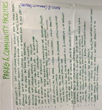
8 BQNB Overcoming Challenges and Filling Gaps Discontinuous waterfront access. Improvements needed to Stadium Road Parks North and South. Poor conditions on some local streets. Pinch points on the Martin Goodman Trail. Traffic congestion on Eireann Quay. Phase 2 Difficult pedestrian crossing at Lake Shore Boulevard and Bathurst Street. I :; ;. = -L - --= ,_..,_-==-=-c:: 8


9 Community Ideas and Priorities Fix traffic on Eireann Quay Improve pedestrian c rossings at corners Keep the basketball courts A waterslide into the lake Use the silos for art and community uses or gardens Plant more trees Prioritize the community pool Improve waterfront connections 9


10 Community Ideas and Priorities BQNB Finalization of Plan 10


11 Testing, Listening, Learning, and Refining BQNB Vision Guiding Principles Phase 3 Action Plan Plan 11

12 Our Shared Vision Bathurst Quay is a successful, vibrant neighbourhood where residents are connected and share a strong sense of place. We are a neighbourhood that celebrates our waterfront location and welcomes all to experience our remarkable waterfront parks and open spaces, and our many heritage, community, and cultural amenities. 12
13 BQNB Guiding Principles to a Complete Neighbourhood Creating a Remarkable Public Realm Enhancing Community Services & Facilities Re energizing the Silos Site & Marina Quay West A New Focus on Movement Improved Parks and Open Spaces Growing Community Services Celebrating Heritage Queen s Quay Improved New Parks and Open Spaces Complete Streets Blue Edge New Aquatic Centre Phase 2 Waterfront Neighbourhood Centre Enhanced Community Building Marina Quay Reinvented Phas e 3 Arts, Culture, Recreation Fin alizati on Taxis of & Parking & Community Uses Pla n Un derground Placemaking Phase 4 Eireann Quay Transformed New Connections 13

14 Neighbourhood Plan Framework 4 n of BATHURST QUAY NEIGHBOURHOOD PLAN FRAMEWORK PLAN,, 14

15 Demonstration Plan Main Features Arts, culture, parks and open space, and community uses. Adaptive re-use of the Silos and Executive Building. Marina Quay West as the site for a new cultural and/or community facility. Aquatic centre and community services and facilities on the Silos site. A bridge to link the Silos site and Marina Quay West. A new waterfront park, promenade and Portland Slip Wave Deck. 15
16 An Action Plan for Success 1. What is Happening Today? Preparing plans Designing improvements 2. The 5 to 10 Year Plan Making improvements Generating new activities P has F e o 2 stering partnerships Advancing long term plans 3. In the Long Term Continuing to improve Creating new destinations Phase Completing 4 the community 16
17 Creating a Remarkable Public Realm What is Here Today? Water s edge Parks and Open Space s Streetscapes.. '-' I 17


18 Creating a Remarkable Public Realm 1 What is Happening. Today? Public Realm and Streetscape Plan design for improvements to open spaces on the Silos site, along streets and park edges. Stadium Road North and South Parks Improvement Plan Phase new2 pathways, landscape and recreation amenities, and a wider Martin Goodman Trail I "CLASSIC" CO IICEPT - STADIUM ROAD PARK "COMM UNITY" CONCEPT - STADIUM ROAD PARK., F,-.,,., "" _,... ""''.,,,., ;,,,.,., l:ot110,llwc, ~«irhti,, l:,,,,.,..,;,.,...,,".. orncr 1t1-.r-d: 1:la~I!",;,?-,... fol, 1,~~ -k...,.-,i,,..,,, = ul. M*.,,.,..,.,,,..tr., lm>1im1>ll & <>l'q<n:!:«i 1>,-.c~, p~m,m:1,,~~,,...,,~,... 18


19 Creating a Remarkable Public Realm The 5 to 10 2.Year Plan Eireann Quay appearance improved and pedestrian experience enhanced wider sidewalks, trees, weather protection, and benches. Stadium Road Parks North and South improved new landscape and recreation amenities, enhanced pedestrian and cycling connections. Waterfront Promenade extended along the Portland Slip and Ireland Park. Phase 2 Portland Slip Wave Deck completed. Marina Quay West improved as a new open space - new activities, landscaping, special paving treatments, lighting, and seating. 19


20 Creating a Remarkable Public Realm 3. In the Long Run Eireann Quay transformed as the neighbourhood main street - new activities, wider sidewalks, generous landscape zones, public art, and seating. New Western Channel Park along the water s edge. Phase 2 Western Channel Waterfront Promenade and Gateway punctuated by a landmark to highlight this historic entrance to the inner harbour. Pha 20


21 Enhancing Community Services and Facilities What is Here Today? Waterfront Neighbourhood Centre Waterfront & City Schools St. Stephens Childcare Phase 3 Phase 4 Finalization of Plan 21


22 Enhancing Community Services and Facilities 1 What is Happening. Today? Waterfront Neighbourhood Centre Facility Needs Assessment to identify current and future programming and space requirements. Phase 2.. -~ ,.-,..._ t( ljfllll M.NA 1.eT~ u,1.1c A!l!'.'tvou, W"'fE~.l<'lOrlf rl-1::im_.,,um MO(lll Q':1/'Tl'~! (lo\-...,,,.,... _.,.,..,,.._...,...,... ~...,.,_,,..,.._,,.,...,,_,. _, "..._..,..., _...,.,_,..,...,....,, 1,... r,e,r.~villt(iijll.ttil(lll'h :)lf)(y1j111r.o 1.-,.v.<:. -,, ,..,.. - ~...,. """>..,...."' _,,...,,,......:,_,.,,...,,,... -~,.,,...,..,,.,.._._,_.., ".,.,,, ,jl,,;.;.,,..- '"",,...,"9-,11.~,i,,...,,.,..,.,.." ""I':,w.. -~ ~ ::::~~o;.,--=~-:=..:: -,, ~,---"11~-..,,..,,... h,..,.-... ~..--~,.,.,,,,.,......,...",_-.,,tk,..,w,v-""v..,_.._,_,._,_ -.,,~-w~-~- _...,._,.,_,,....,,.,..,..,,._tt...,.. u.._r><.,....,,...,,...:nu -.,JU0-9'0...,...,,._.. "'l<-'"-''"'' ""'.,,;u.,:o..,.or,.._.,...,_,_..,..._,.,......,.,...,.~...,..., ,.,,r,,.,... u.,...-.,... l",-..,,-.., ~,~...,,.,.. t.01,0,,oao.t _,...,..-,...,.,,.,,.,..,.,,....,,...,._.,,;u_,.,,.., ~,....,.._.,.._,..,.,,._.,. 22


23 Enhancing Community Services and Facilities 2. The 5 to 10 Year Plan Aquatic Centre analysis to further investigate Silos site opportunity. Waterfront Neighbourhood Centre improvements including new space to grow community services. Improved open spaces arou Pha nd se 2 the community facilities for shared use. C TOcore Study Area Future Opportunities Bathurst Quay Aquatic Centre Pha 23


24 Enhancing Community Services and Facilities,:..,.....,,,h... ~u~ru-... rw,.,.h:n 3. In the Long Term A new Aquatic Centre on the Silos site integrated with new community facilities. 24

25 Re-energizing the Silos Site and Marina Quay West What is Here Today? Historically significant Canada Malting Silos and Executive Building Marina Quay West Ireland Park Taxi staging area and parking Phase 2 Unimproved open spaces 25
26 Re-energizing the Silos Site and Marina Quay West 1 What is Happening. Today? A Vision for a new Waterfront Destination focussed on arts, culture, parks and open space, and community uses on the historic Canada Malting Silos Site and Marina Quay West. Phase 2 26


27 Re-energizing the Silos Site and Marina Quay West 2. THE 5 to 10 YEAR PLAN A Strategy to bring new activity to the Silos site - markets, food trucks, arts, cultural, and community festivals. Improved open spaces on the Silos site - a new public square as a gathering place for the neighbourhood. Phas e 2 A Plan for the adaptive re-use of the Silos and Executive Building, and new cultural and/or community uses on Marina Quay West. 27


28 Re-energizing the Silos Site and Marina Quay West 3. In the Long Term Silos site and Marina Quay West as a new Waterfront Destination. Arts, culture, parks and open space, an d community uses. Adaptive re-use of the Silos & Executiv e Building A new Marina Quay West cultural and/o r community facility. Silos site and Marina Quay West linked by a pedestrian bridge. 1nst1t11t ot Contecmpo1MyA1t, Boston 28


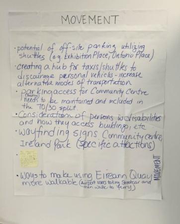
29 A New Focus on Movement The Challenges Today Airport traffic and congestion on Eireann Quay. Martin Goodman Trail pinch points at the Portland Slip and Stadium Road Park North. Difficult pedestrian crossings at the Queen s Quay and Eireann Quay, and Bathurst Street, Lake Shore Boulevard and Fleet Street Phase intersections. 2 P ha Parking and traffic congestion on local streets. 29


30 A New Focus on Movement 1 What is Happening. Today? Martin Goodman Trail widened at the Portland Slip. Off-street taxi staging on the Silos site to manage traffic. Airport pedestrian tunnel constructed to improve pedestrian accesspha andse 2 reduce traffic congestion. Pha 30


31 A New Focus on Movement 2. The 5 to 10 Year Plan Martin Goodman Trail widened at Stadium Road Park. Eireann Quay improvements wider sidewalks, street trees, and pedestrian amenities. New bike share stations and cycling infrastructure. Traffic operations assessment P o ha f s th e e 2 Bathurst Street, Lakeshore Boulevard, and Fleet Street intersection. Feasibility study of full or partial closure of Fleet Street. 31


32 A New Focus on Movement 3. In the Long Term Taxi staging and parking moved underground. Stadium Road parking lot removed and new Waterfront Park created. Queen s Quay transit, cycling and pedestrian improvements extended Phase from 2 Spadina Avenue to Bathurst Street. New bridge over the Portland Slip to link the Silos site and Marina Quay West. 32
33 Preliminary Policy Directions 1. Maintain the Parks and Open Space Areas land use designation on City-owned lands within Bathurst Quay. Official Plan ,.. - ' '~~ - -,,_,..,_ C Pha!.,. :;.::;::_ P :.:::~.:::..,... ~.,:~ -::-~--:::. 33
34 Preliminary Policy Directions 2. Develop a more detailed Plan to transform the Canada Malting Silos Site and Marina Quay West into a Waterfront Destination including: - A focus on arts, culture, parks and open space, and community uses. - The conservation and adaptive re-use of the historic Canada Malting Silos and Executive Building. - Marina Quay West as the site for a new cultural and/or community facility. - An Aquatic Centre and new Community Services and Facilities on the Silos Site. Phase 2 Phase 3 Phase 4 - A bridge to link the Silos Site and Marina Quay West. Finalization of Plan 34
35 Preliminary Policy Directions 3. Develop a strategy including opportunities for partnerships to bring new uses and activity to the Canada Malting Silos Site, the Executive Building and Marina Quay West in the near term as catalysts for longer term re-vitalization. 4. Develop a Streetscape and Public Realm Plan to provide a framework for public realm enhancements over time including: - improved north to south and east to west connections for pedestrians & cyclists; - improved physical and visual access to the water s edge; and Phase 2 Phase 3 Phase 4 Finalization of Plan - new and existing parks, open spaces and streetscapes designed for a variety of experiences and functions. 35
36 Summary and Next Steps Improve the Public Realm: continuing implementation and new design work for small and large public realm improvements Enhance Community Services & Facilities: preparing facility needs assessment and aquatic centre analysis Re-energize the Canada Malting Silos Site and Marina Quay West: new vision for a community and cultural hub; strengthened policy framework in final report to Council SpringPha20se172 Phase 3 Phase 4 Finalization of Plan Improve Movement in the Neighbourhood: multiple improvements recently completed, getting underway, and/or started planning 36
37 BATHURST QUAY NEIGHBOURHOOD PLAN THANK YOU FOR PARTICIPATING 37
Welcome. Community Consultation Meeting November 28, Review and discuss the Bathurst Quay Neighbourhood Plan Framework
 Welcome Community Consultation Meeting November 28, 2016 Why Are We Here Today? Review and discuss the Bathurst Quay Neighbourhood Plan Framework Review and discuss an Action Plan for Implementation Next
Bathurst Quay Neighbourhood Plan Interim Report
 STAFF REPORT ACTION REQUIRED Bathurst Quay Neighbourhood Plan Interim Report Date: June 8, 2017 To: From: Wards: Reference Number: Toronto and East York Community Council Director Community Planning, Toronto
Chairman and Members of the Planning and Development Committee. Thomas S. Mokrzycki, Commissioner of Planning and Building
 LA.09.TOR (Toronto) DATE: TO: FROM: SUBJECT: Chairman and Members of the Planning and Development Committee Thomas S. Mokrzycki, Commissioner of Planning and Building Central Waterfront Secondary Plan
BATHURST QUAY NEIGHBOURHOOD PLAN IMPLEMENTATION. Streetscape & Public Realm Improvement Plan - Canada Malting Silo Site and Eireann Quay
 BATHURST QUAY NEIGHBOURHOOD PLAN IMPLEMENTATION Streetscape & Public Realm Improvement Plan - Canada Malting Silo Site and Eireann Quay Bryan Bowen, Waterfront Secretariat November 25, 2017 Presentation
Summary of Results from the Toronto Planning Review Panel Meeting held June 10, 2017 Executive Summary
 Summary of Results from the Toronto Planning Review Panel Meeting held June 10, 2017 Executive Summary The Planning Review Panel is a representative group of Torontonians, made up of 28 randomly selected
PRELIMINARY DESIGN + DEVELOPMENT PLAN
 WELCOME! To The Public Open House May 30 th, 2017 HARBOUR WEST PARKS Vision Project Overview The City s vision for Port Credit Harbour West Parks is to develop a vibrant waterfront destination that integrates
Lambeth Main Street Streetscape Improvements
 Lambeth Main Street Streetscape Improvements Open House October 5th, 2017 Agenda 1. Introduction 2. Project Background 3. Context 4. Project Objectives 5. Design Principles & Approach 6. Streetscape Design
Don Mills Crossing Study and Celestica Lands Development Application Community Meeting, Open House, and Breakout Discussions
 Consultation Summary Don Mills Crossing Study and Celestica Lands Development Application Community Meeting, Open House, and Breakout Discussions This report is not intended to provide a verbatim transcript
Workshop 3. City of Burlington Waterfront Hotel Planning Study. September 14, The Planning Partnership
 Workshop 3 City of Burlington Waterfront Hotel Planning Study September 14, 2017 The Planning Partnership The Waterfront Hotel Planning Study 01 The Brant & Lakeshore Planning Study will establish a Strategic
Shared Principles and Emerging Plan Directions
 Shared Principles and Emerging Plan Directions Introduction Since the Fairfield Neighbourhood planning process launched in June 2016, we have heard from many residents, businesses, groups and other people
The Master Plan Framework
 The Master Plan Framework The East Harbour Master Plan advances the development of 60 acres of former industrial lands east of the Don River. The Master Plan outlines a vision for a vibrant, transit-oriented
DOWNTOWN PARKS & PUBLIC REALM PLAN
 DOWNTOWN PARKS & PUBLIC REALM PLAN CHALLENGES The Parks and Public Realm Strategy addresses challenges associated with a growing Downtown, including: GOALS 3.3 New buildings will fit within their existing
PLAN ELEMENTS WORKSHOP. April 5, 2016
 PLAN ELEMENTS WORKSHOP April 5, 2016 needs more housing. But there is no one-size fits-all solution. Every neighborhood has its own character. In some places, density is not only appropriate it is badly
CAMBIE CORRIDOR PLAN
 1 WELCOME TO THE OPEN HOUSE PUBLIC REALM PLAN - CAMBIE CORRIDOR Thank you for coming to the Cambie Corridor Public Realm Open House! Place a dot where you live Please provide us with your comments and
Building Great Neighbourhoods. Strathcona
 Building Great Neighbourhoods Strathcona March 21, 2018 Becky Redford Project Manager, Planning & Design Building Great Neighbourhoods Integrated Infrastructure Services Welcome and Purpose To provide
Public Meeting #3 May 9, 2009 MVVA Team
 Public Meeting #3 May 9, 2009 MVVA Team Welcome to the third Public Meeting for the Lower Don Lands Municipal Class Environmental Assessment (EA) Infrastructure Master Plan and Keating Channel Precinct
Purpose of Open House #3
 Public Meeting #3 May 9, 2009 MVVA Team Purpose of Open House #3 The main purpose of this Open House is to present and seek input on the: Evaluation of transportation and infrastructure design alternatives
GUIDELINES EXHIBITION PLACE LOCATION: OBJECTIVES. Structure Plan URBAN DESIGN GUIDELINES
 Development in the Exhibition Place lands will be consistent with the following urban design guidelines. They provide a framework for new development of the lands and are to be read in conjunction with
WELCOME and introduction
 1 WELCOME and introduction Mobility Hub Locations within Burlington STUDY OVERVIEW STUDY OBJECTIVES The City of Burlington is developing four Area Specific Plans, one for each of Burlington s Mobility
5 Eireann Quay Site Plan Control Application
 STAFF REPORT ACTION REQUIRED 5 Eireann Quay Site Plan Control Application Date: March 12, 2015 To: From: Wards: Reference Number: Toronto and East York Community Council Director, Community Planning, Toronto
Table 8-4: Road Classification Local Roads, second table, of Chapter 8 Create a Multi-Modal City, be amended by adding the following:
 1 Port Street East Official Plan Amendment APPENDIX 3 Amendments to Mississauga Official Plan Table 8-4: Road Classification Local Roads, second table, of Chapter 8 Create a Multi-Modal City, be amended
Welcome. Green Line LRT. Beltline Alignment Options. Stay engaged! Follow the Green Line story at calgary.ca/greenline
 Welcome Green Line LRT Beltline Alignment Options Stay engaged! Follow the Green Line story at calgary.ca/greenline Green Line LRT Why are we here? Our Challenge Determine the best alignment in the Beltline.
planning toronto s downtown Parks and Public Realm Plan Request for Proposals Information Meeting Andrew Farncombe, Project Manager August 19, 2015
 planning toronto s downtown Parks and Public Realm Plan Request for Proposals Information Meeting Andrew Farncombe, Project Manager August 19, 2015 BATHURST ST Keeping Downtown a great place to live, work,
University of Saskatchewan CAMPUS MASTER PLAN. Senate Meeting Preliminary Presentation. April 21, 2018 DIALOG ECS DA WATT
 University of Saskatchewan CAMPUS MASTER PLAN Senate Meeting Preliminary Presentation April 21, 2018 DIALOG ECS DA WATT project process presentation agenda Stakeholder Engagement Project Control phase1
Coordinated Transit Planning in Toronto SmartTrack GO RER Scarborough Relief Line Waterfront Transit
 Coordinated Transit Planning in Toronto SmartTrack GO RER Scarborough Relief Line Waterfront Transit Public Information Centres February 2016 Transportation Planning Section City Planning Division Toronto
38 Queen s University Campus Master Plan Part 1
 38 Queen s University Campus Master Plan Part 1 46 The Campus at the City Scale Chapter 4 The Campus at the City Scale 39 Queen s is an urban University centrally located in Kingston. Decisions made by
Welcome! Rail Corridor Land Use Study Public Meeting #2
 Welcome! Rail Corridor Land Use Study Public Meeting #2 Tonight is an opportunity to learn about and provide input on the proposed planning framework and emerging directions for the Rail Corridor Site
PLANNING ADVISORY BOARD AGENDA OCTOBER
 ! City of Langley PLANNING ADVISORY BOARD AGENDA OCTOBER 1, 2014 3-5pm LANGLEY CITY HALL - 112 2 nd Street, Langley WA 1) Call to Order and Roll Call 2) Approval of the Minutes September 10, 2014 3) Public
Pedestrian and Bike Bridge LOGO
 6.2.2 Pedestrian and Bike Bridge The proposed pedestrian and bike crossing re-envisions the existing bridge at Pismo Creek on Cypress Street. The bridge is currently underutilized by vehicular through
King-Spadina Secondary Plan Community Consultation Meeting. Michelle Knieriem, City Planner October 11, 2017
 King-Spadina Secondary Plan Community Consultation Meeting Michelle Knieriem, City Planner October 11, 2017 Agenda 6:30 Welcome 6:35 Presentation 7:15 Question and Answer Session 8:15 Closing Remarks HOW
Town of Cobourg Heritage Master Plan. Statutory Public Meeting
 Town of Cobourg Heritage Master Plan Statutory Public Meeting April 25 th 2016 Presentation Overview 1. Introduction 2. Project background and schedule overview 3. Review of strategic direction content
Evaluation Criteria. Detailed Evaluation Criteria
 Evaluation Criteria Detailed Evaluation Criteria Community Well-being A safe and socially inclusive service that improves access to key community destinations and provides transportation choices for Calgarians.
SECTION ONE: INTRODUCTION. introduction
 introduction 1 INTRODUCTION Since it was first established in 1843 as a trading post for the Hudson s Bay Company, Victoria has evolved into a Provincial capital city that is recognized across Canada and
4- PA - LD - LIVELY DOWNTOWN. LD - Background
 4- PA - LD - LIVELY DOWNTOWN LD - Background The downtown has been the service centre for the community since the city s inception and the area continues to supply people with their personal services,
Mark-up of the effect of the proposed Bronte Village Growth Area OPA No.18 on the text of section 24, Bronte Village, of the Livable Oakville Plan
 Mark-up of the effect of the proposed Bronte Village Growth Area OPA No.18 on the text of section 24, Bronte Village, of the Livable Oakville Plan Notes: This document is provided for information purposes
Bloor Street East Potential Ravine Portal Overlook and Access Passage to the Rosedale Valley and Don River Valley Ravine, Toronto, Canada
 TRANSFORMATIVE IDEA 2. GREAT STREETS Bloor Street Christie Pits Park Bloor St Spadina Ave Bathurst St Shaw St 1 Recognize the significant public realm improvements along Bloor Street and extend and enhance
CHAPPLES PARK MASTER PLAN
 CHAPPLES PARK MASTER PLAN Presentation of Preliminary Development Options Public Open House #2 Wednesday November 2 nd, 2016 TONIGHT S AGENDA 1. Welcome & Introductions 2. Presentation by Sierra Planning
A 25-YEAR PLAN FOR DOWNTOWN
 A 25-YEAR PLAN FOR DOWNTOWN The Downtown Secondary Plan will provide policy direction to shape future growth and link that growth to the provision of infrastructure for liveability 1. BALANCING GROWTH
Plan Framework Report. Attachment A
 Plan Framework Report Attachment A Uptown-Douglas Corridor Plan - Plan Framework Report Contents Introduction... 1 Planning Process... 3 Project Objectives... 4 Vision... 5 Community Values... 6 Structural
CHAPTER 5: GUIDING PRINCIPLES
 CHAPTER 5: GUIDING PRINCIPLES The following 10 principles were developed based on public consultation, planning policy and the background analysis conducted during Phase 1. The Guiding Principles significantly
Canadian Consulting Engineering Awards 2016 Queens Quay West Revitalization. Category B: Transportation
 Canadian Consulting Engineering Awards 2016 Queens Quay West Revitalization Category B: Transportation April 2016 Arup Contents Online Submission Confirmation Receipt Entry Consent Form Project Information...1
Johnson Street Bridge Public Realm Update
 Johnson Street Bridge Public Realm Update August 20, 2015 Background Johnson Street Bridge Replacement Project impacts a diverse range of stakeholders In addition to a new bridge, the project also includes
ELMVALE ACRES SHOPPING CENTRE MASTER PLAN
 ELMVALE ACRES SHOPPING CENTRE MASTER PLAN Contents 1.0 INTRODUCTION... 2 2.0 LOCATION... 2 3.0 EXISTING CONTEXT... 2 4.0 VISION & GUIDING PRINCIPLES... 2 5.0 LAND USE AND BUILT FORM... 4 5.1 St. Laurent
Figure 3-1: Public Realm Plan
 3 Public Realm Figure 3-1: Public Realm Plan 3.1 Public Realm Concept The public realm concept for the Little Mountain site integrates a clear and accessible movement network with public spaces for social
appendix and street interface guidelines
 appendix five: building and street interface guidelines appendix 5 building and street interface guidelines BOULEVARDS Boulevards are generally characterized by higher levels of traffic movement at higher
Welcome. Walk Around. Talk to Us. Write Down Your Comments
 Welcome This is an information meeting introducing the applications for proposed redevelopment of the Yorkdale Shopping Centre site at 3401 Dufferin Street and 1 Yorkdale Road over the next 20+ years,
Corridor Vision. 1Pursue Minnehaha-Hiawatha Community Works Project. Mission of Hennepin County Community Works Program
 1Pursue Minnehaha-Hiawatha Community Works Project Minnehaha-Hiawatha Community Works is a project within the Hennepin Community Works (HCW) program. The mission of the HCW program is to enhance how the
Toronto Complete Streets Guidelines
 c. DTAH 58 60 3.1 70 3.2 Performance Measurement 71 3.3 Exceptions Chapter 3 describes the five general steps in the street design process. Not all projects follow these steps, as the number of steps and
Welcome to the Oakridge Centre Open House
 Welcome to the Oakridge Centre Open House Why is the City hosting this event? This open house is to inform you of a rezoning application submitted to the City of Vancouver to amend the existing CD-1 (Comprehensive
Animating the Rideau Canal December 2013
 Executive Summary Animating the Rideau Canal December 2013 Why study the Rideau Canal? The Rideau Canal has been an important part of Ottawa throughout its history, and has shaped and been shaped by the
New-Cast Mixed-use Development Proposal King Street West, Newcastle, Ontario
 URBAN DESIGN BRIEF New-Cast Mixed-use Development Proposal King Street West, Newcastle, Ontario TABLE OF CONTENTS: 1.0 Executive Summary 2.0 Creating Vibrant and Sustainable Urban Places: Excerpts from
Urban Design Manual PLANNING AROUND RAPID TRANSIT STATIONS (PARTS) Introduction. Station Study Areas
 Introduction. Station Study Areas") 111111 PLANNING AROUND RAPID TRANSIT STATIONS (PARTS) Introduction The ION rapid transit system will link Waterloo, Kitchener and Cambridge through a central transit corridor (CTC). There are a number
111111 PLANNING AROUND RAPID TRANSIT STATIONS (PARTS) Introduction The ION rapid transit system will link Waterloo, Kitchener and Cambridge through a central transit corridor (CTC). There are a number
Lakeview and Port Credit District Policies Review Public Engagement Process
 Lakeview and Port Credit District Policies Review Public Engagement Process Brook McIlroy Planning + Urban Design/PACE Architects MSAi Architects Poulos and Chung Transportation Engineers December 11,
PUBLIC MEETING AND OPEN HOUSE: Don Mills Crossing Phase 2 Celestica Development Applications. February 21, 2017
 PUBLIC MEETING AND OPEN HOUSE: Don Mills Crossing Phase 2 Celestica Development Applications February 21, 2017 PURPOSE OF TONIGHT S MEETING Engage the community on the Don Mills Crossing Study and development
The Project. In 2013, construction was completed between 100 Street and 102 Street.
 The Project Jasper Avenue New Vision (JANV) is a major catalyst project identified in the Capital City Downtown Plan (2010) between 92 Street and 109 Street, including the streets half a block north and
The University District envisions, in its neighborhood
 Envisioning the University District Link Light Rail in Seattle s neighborhoods CIY OF SEALE CONCEP-LEVEL SAION AREA PLANNING RECOMMENDAION RESOLUION # 30165 EXHIBI L Vision 08.2000 he University District
Thank you for coming to the Rail Corridor Land Use Study Public Meeting.
 01 Welcome! Thank you for coming to the Rail Corridor Land Use Study Public Meeting. Tonight is an opportunity to learn about the Land Use Study for the Rail Corridor Site. In Fall 2016, Toronto City Council
Key Moves in the Plan
 Key Moves in the Plan 2 Add housing that fits the neighbourhood s character Make it easier to leave the car behind Oak Bay Avenue Village plan to be completed in future planning process Future active transportation
Imagining Ward 3 Session #2. April 18, :00 pm 8:30 pm
 Imagining Ward 3 Session #2 April 18, 2016 7:00 pm 8:30 pm Project Team City of Mississauga Karen Crouse, Project Leader, Policy Planning Division Frank Marzo, Planner, Policy Planning Division Brook McIlroy
Parks Master Plan Implementation: Phase I Waterfront Use and Design REPORT #: September 7, 2016 File #
 0 'O DI Lan-171-14 1 - THE CORPORATION OF THE TOWN OF COBOURG..,. STAFF REPORT TO: FROM: Mayor and Members of Council Dean A. Hustwick, Director of Recreation and Culture DATE OF MEETING: Committee of
PIKE PINE RENAISSANCE: ACT ONE. October 19, 2017
 PIKE PINE RENAISSANCE: ACT ONE October 19, 2017 WATERFRONT SEATTLE PROGRAM PROJECT INTRODUCTION Pike and Pine streets, between First and Melrose avenues Pedestrian and streetscape improvements Budget:
8. Urban Villages. Other Relevant Policies & Bylaws Official Community Plan Development Permit Area Designations and Guidelines
 8. Urban Villages Urban villages provide walkable shops and services, encourage a neighbourhood social life, create a sense of place and provide different housing options. More housing near Urban Villages
Hamilton Pier 7&8 Draft Urban Design Plan
 Hamilton Pier 7&8 Draft Urban Design Plan Public Open House October 29, 2015 Contents 1. Study Overview 2. Area Design Goals 3. Urban Structure 4. Public Realm 5. Urban Design Plan Options 6. Next Steps
WEST LOOP DESIGN GUIDELINES CHECKLIST
 WEST LOOP DESIGN GUIDELINES CHECKLIST Section 1.0 General Strategies 1.1 DESIGN EXCELLENCE: ENCOURAGE HIGH QUALITY AND INNOVATIVE DESIGN OF NEW BUILDINGS WITHIN THE WEST LOOP WITHOUT BEING PRESCRIPTIVE
How can we improve mobility and access?
 How can we improve mobility and access? North King s Town is located fairly centrally within the city, but there are still multiple opportunities to improve mobility within the study area, including connections
Report to: Development Services Committee Report Date: April 24, 2017
 SUBJECT: Cornell Rouge National Urban Park Gateway - Report on Design Charrette and Next Steps PREPARED BY: Lilli Duoba, MES, MCIP, RPP, Manager, Natural Heritage (ext. 7925) REVIEWED BY: Marg Wouters,
Neighborhood Districts
 NEIGHBORHOOD DISTRICTS SEVEN MAIN DISTRICTS Neighborhood Districts While the Development Plan provides a broad-scale overview of the neighborhood, this section focuses on uses and relationships at the
QUESTION 8: What are your Public Realm priorities for implementation? What would you like to see happen first? TELL US WHAT YOU THINK
 Public Realm Plan How will the Public Realm Plan be implemented? The Public Realm Plan document will set out a vision for the next 30 years. Over time, Plan elements and aspects can be implemented as opportunities
LAKEVIEW VILLAGE VISION & MASTERPLAN PRESENTATION TO CITY OF MISSISSAUGA. April 9, 2018
 LAKEVIEW VILLAGE VISION & MASTERPLAN PRESENTATION TO CITY OF MISSISSAUGA April 9, 2018 AGENDA Introduction Vision Plan Comparison The Big Moves Trail Connections Plan Overview Districts Conveyance Comparison
Mavis Road Class Environmental Assessment
 Mavis Road Class Environmental Assessment Public Information Centre #2 Wednesday November 9, 2016 6:00 to 8:00 p.m. Please sign in and complete a comment sheet Review the displays on your own or join in
Study Area. Capitol Way. Greening America s Capitals 11/13/2014. A Greening America s Capitals Project
 Olympia, WA: Greening Capitol Way Supporting Communities move towards sustainability is a priority for the federal government. A Greening America s Capitals Project Office of Sustainable Communities U.S.
open house 3 CITY OF SALEM Downtown Streetscape Plan
 open house 3 Streetscape concepts CITY OF SALEM Downtown Streetscape Plan analysis concepts we are here refined concepts & document Feb 13th 1 2 3 apr 18th KICKOFF OPEN HOUSE Streetscape Work Group Walking
Ivywild On The Creek PRELIMINARY CREEK DISTRICT MASTER PLAN
 Ivywild On The Creek PRELIMINARY CREEK DISTRICT MASTER PLAN Introduction: Rejuvenating an extraordinary Creekside neighborhood THE CREEKSIDE DISTRICT The Ivywild On The Creek Neighborhood District Master
2.0 Urban Design Concepts
 0 Urban Design Concepts Urban Design Concept diagrams The Waterfront Axis The Park Axis The Wharf Axis Waterfront Precincts 0.1 The Four Key Concepts: This Concept for the Wynyard Quarter establishes four
City of Toronto. Emery Village Transportation Master Plan
 City of Toronto Emery Village Transportation Master Plan May 2009 Emery Village Transportation Master Plan Toronto, ON May 2009 Consulting Inc. 100 York Blvd., Suite 300 Richmond Hill, ON L4B 1J8 Tel:
Director, Community Planning, Toronto and East York District
 Lower Yonge Precinct Plan Update STAFF REPORT ACTION REQUIRED Date: October 16, 2012 To: From: Wards: Reference Number: Toronto and East York Community Council Director, Community Planning, Toronto and
Public Workshop: November 12, 2009
 Marlboro Hamlet Master Plan Public Workshop: November 12, 2009 Agenda Project Introduction Land Use Concepts and Zoning Connectivity and Gateways New Development Hamlet Center Open Space and Recreation
FROM DUPONT CIRCLE NORTH TO CALIFORNIA STREET, NW. Welcome!
 FROM DUPONT CIRCLE NORTH TO CALIFORNIA STREET, NW Welcome! Meeting Agenda 6:00 PM Open House 6:30 PM Presentation 7:00 PM Open House / Q&A at the Boards Project Design Team Connecticut Avenue, NW Project
OVERVIEW NEW PARK AT 318 QUEENS QUAY WEST
 OVERVIEW NEW PARK AT 318 QUEENS QUAY WEST A new 9,600m 2 (0.96 Ha) waterfront park is being designed at 318 Queens Quay West on Toronto's Central Waterfront. The site is bordered by Queens Quay Blvd to
Port Credit Local Advisory Panel October 20 th Meeting
 Port Credit Local Advisory Panel October 20 th Meeting Focus Of This Evening s Meeting: 1. Hurontario Main Street Higher Order Transit Study 2. Port Credit Mobility Hub & GO Station Parking Structure Study
Parks Renaissance. Strategy. Director, Operations. General Committee. Presentation to. May 16, Barb Rabicki
 1 Parks Renaissance Strategy Presentation to General Committee May 16, 2016 Barb Rabicki Director, Operations Incorporates recommendation to complete Parks Renaissance Strategy Feedback / requests from
CENTRAL ESTUARY PLAN AVISION FOR OAKLAND S WATERFRONT
 Central Estuary Plan A VISION FOR OAKLAND S WATERFRONT Specific Plan and Environmental Assessment Presentation to the Parks and Recreation Advisory Commission December 9, 2009 This Afternoon s Presentation
East Bayshore Road Neighbourhood
 East Bayshore Road Neighbourhood Northridge Property Management Urban Design Brief 3195 East Bayshore Road City of Owen Sound January 2016 East Bayshore Road Neighbourhood Northridge Property Management
City of Farmington. Downtown Plan. Amendment to the 1998 Master Plan Adopted October 11, 2004
 City of Farmington Amendment to the 1998 Master Plan Adopted October 11, 2004 Introduction Planning Background 1 Scope and Components of the Plan Amendment 2 Concept Introduction 3 Plan Concepts 3 Conceptual
burlington mobility hubs study Downtown Burlington Mobility Hub
 burlington mobility hubs study Downtown Burlington Mobility Hub Draft Precinct Plan Workbook PIC #3, September 7, 2017 downtown mobility hub objectives City staff and their consultants are proposing an
3.0 master plan concept
 3.0 master plan concept 3.1 introduction The purpose of the Huron Church Road Master Plan Concept is to provide an overview of the Master Plan design process, identify preliminary streetscape installations
Public Consultation Summary: Lakeview Place Making Workshop January 30, 2008.
 Page 1 of 11 Public Consultation Summary: Lakeview Place Making Workshop January 30, 2008. 1.0 Introduction: On January 30, 2008 the City of Mississauga, in conjunction with the consulting team of Brook
Port Lands Planning Initiatives - Final Report
 RE: PG23.6 Port Lands Planning Initiatives - Final Report Planning and Growth Management Committee October 2017 1-2017-10-12 Existing Conditions - Defining Elements Heritage Buildings + Structures Active
11.5 Kipling Avenue Corridor Secondary Plan
 11.5 Kipling Avenue Corridor Secondary Plan ADOPTED BY VAUGHAN CITY COUNCIL NOT YET APPROVED BY THE ONTARIO MUNICIPAL BOARD 11.5.1 Development Principles and Objectives The following principles support
CITY OF VAUGHAN KIRBY GO TRANSIT HUB SUB-STUDY
 WELCOME! Thank you for attending, and welcome to the first of three Public Meetings for the Kirby GO Transit Hub Study. Your feedback is important to us, and will help inform the development of the draft
Waterfront Project VISION, GOALS AND OBJECTIVES
 Waterfront Project VISION, GOALS AND OBJECTIVES INTRODUCTION The City of North Vancouver created the Waterfront Project in 2005 in order to provide a focus for waterfront redevelopment opportunities and
Community Open House March 26 th, 2018
 Community Open House March 26 th, 2018 Open House Agenda 1. Overview of Planning Process What we heard 2. Future Land Use Policy 3. Priority Growth Areas 4. Plan Elements Making it happen What is a Comprehensive
V. Gateways GATEWAYS / V-1
 V. GATEWAYS / V-1 Many of Chesapeake s gateways are located on highways and call for bold and attractive designs that motorists can understand, appreciate, and enjoy. can also take the form of natural
PLACEMAKING & MOBILITY WORKSHOP. January 27, 2016
 PLACEMAKING & MOBILITY WORKSHOP January 27, 2016 Boston needs more housing. But there is no one-size fitsall solution. Every neighborhood has its own character. In some places, density is not only appropriate
Baselands Trails Master Plan Public Meeting. April 28, 2015 Fire Academy, 895 Eastern Avenue, Toronto 6:30 p.m. to 9:00 p.m.
 Baselands Trails Master Plan Public Meeting April 28, 2015 Fire Academy, 895 Eastern Avenue, Toronto 6:30 p.m. to 9:00 p.m. Baselands Trails Master Plan Meeting Purpose To present and get feedback on:
Commissioners Road West Realignment Environmental Assessment
 City of London Commissioners Road West Realignment Environmental Assessment Public Information Centre No. 1 March 30, 2017 Welcome to the Public Information Centre This first Public Information Centre
NORTH SHORE LAND USE AND TRANSPORTATION STUDY
 NORTH SHORE LAND USE AND TRANSPORTATION STUDY Visioning Open Houses April 6 and 7, 2009 Port Richmond and Snug Harbor Project Sponsors New York City Economic Development Corporation New York City Department
DOWNTOWN GEORGETOWN PLANNING STUDY
 DOWNTOWN GEORGETOWN PLANNING STUDY Community Workshop #3 Thursday, May 4, 08 The Planning Partnership OVERVIEW OF STUDY, PROCESS & MILESTONES We are here PURPOSE OF THE STUDY To develop a clear vision
2035 General Plan Update and Belmont Village Specific Plan. Joint Study Session with the City Council and Planning Commission April 12, 2016
 2035 General Plan Update and Belmont Village Specific Plan Joint Study with the City Council and Planning Commission April 12, 2016 Agenda 1. Welcome and Introductions 2. General Plan Update Status of
GLEN ROAD PEDESTRIAN BRIDGE ENVIRONMENTAL ASSESSMENT STUDY PUBLIC INFORMATION CENTRE #2 OCTOBER 24, 2017
 GLEN ROAD PEDESTRIAN BRIDGE ENVIRONMENTAL ASSESSMENT STUDY PUBLIC INFORMATION CENTRE #2 OCTOBER 24, 2017 Glen Road Pedestrian Bridge Class Environmental Assessment 1 WELCOME! Welcome to the second Public