OVERVIEW NEW PARK AT 318 QUEENS QUAY WEST
|
|
|
- Marjory Strickland
- 6 years ago
- Views:
Transcription


1 OVERVIEW NEW PARK AT 318 QUEENS QUAY WEST A new 9,600m 2 (0.96 Ha) waterfront park is being designed at 318 Queens Quay West on Toronto's Central Waterfront. The site is bordered by Queens Quay Blvd to the south, Rees Street to the east, the Gardiner Expressway to the north, and 350 Queens Quay West (a residential condominium) to the West. FUTURE VISION FOR PARK When completed, the New Park at 318 Queens Quay will serve as a keystone, unlocking the potential of the emerging network of parks along our Waterfront for area residents and waterfront park users citywide.


.")
2 SITE HISTORY ON THE WATERFRONT QUEENS QUAY THROUGH THE YEARS. Industrial past of site: Home to the Maple Leaf Mills Silos The Federal government expropriated the Maple Leaf complex in as part of the redevelopment of Harbourfront. 318 QUEENS QUAY BLVD W 1997 Federal Government conveyed the 2.65 acre to the City as a to be developed as a future public park. PETER STREET SLIP The site is part of the 40 acres of land intended for parks and open spaces, as outlined in the Harbourfront Implementation Agreement (HIA) between the Government of Canada, Harbourfront Corporation and the City of Toronto (1992). The site is currently being leased as a public parking lot by Harbourfront Centre. Turning Basin QUEENS QUAY BLVD W PETER STREET SLIP Turning Basin QUEENS QUAY BLVD W PETER STREET SLIP Turning Basin
3 SITE CONTEXT + CONNECTIONS The new design at 318 Queens Quay will need to address neighbourhood connections and complement and enhance important Waterfront features. WEST Maple Leaf Quay Courtyard and Turning Basin Residential and Commercial Uses Development application in progress EAST Rees Street Sidewalk/Street connection to North Residential and Commercial Uses Rees Street Parkette NORTH Roundhouse Park and Roger s Centre Tourist destination in City Key connection route to downtown core Lakeshore Blvd. and Gardiner Primary vehicular circulation access point Existing Pedestrian and Cycling Connections SOUTH HTO Park and Lake Destination Park on the Waterfront Urban Beach Waterfront Promenade Martin Goodman Trail connections along Queens Quay Blvd. Clear views to HTO Park and Lake Ontario beyond
4 GUIDING PRINCIPLES In October 2016, a workshop was held with local stakeholder organizations to identify priorities, key themes and needs for the future park, described as Guiding Principles. A Winter City Park for All Season Use Create Opportunities for Curiosity and Experimentation Connected And Relevant A Systems Thinking Design Approach Innovation and Sustainability Complement rather than Compete with Existing Context Encourage Community Stewardship and Collaborative Partnerships Technical analysis and Budgets, together with public and stakeholder input on guiding principles, park program and future park concepts will inform the final park design.
5 YOUR IDEAS AND COMMENTS HERE...


")


6 e St Yong W St t St Fron lvd ner B m e r B Olympic Park Yo r k Victoria Memorial Park CN Tower Port Rogers Centre t ys Ba f Crt Whar Navy ve ina A Spad St ur o b r Ha t oe S St hern t r o N k r Par a e n Li c Sim land ay ys W a J e Blu Roundhouse Park ay s St Ree t urst S Bath (future) Mouth of the Creek Park lvd B York Fort r Park a e n i ern L South Fort York Dan Xy E diner r a G FG dw ore Blv h S e Lak n Trail Canada Square 318 Queens Quay 500m ay kie W Lec Canoe Landing M ar t dma in Goo E n ee Qu u sq HARBOUR SQUARE PARK Harbour Front Centre ay W s Qu n e e Qu Toronto Island Ferry Terminal Boardwalk Open lawn Ornamental Fountain Seating Fieldhouse YORK STREET OFF RAMP PARK Open lawn SIMCOE WAVEDECK SPADINA WAVEDECK Wooden deck structure Seating IRELAND PARK TORONTO MUSIC GARDEN SPADINA QUAY WETLANDS Horticultural gardens Performance space Ornamental fountain Open lawn + fieldhouse Drinking fountains Wetland Viewing deck Information boards HTO PARK REES WAVEDECK Urban beach Mounded greenspace Seating Drinking fountains Showers Wooden deck structure Seating Wooden deck structure Seating TORONTO WATERFRONT PARK REES STREET PARK Linear boardwalk with seating Open lawn Playground Seating PETER STREET BASIN Boardwalk Ornamental fountain m) 0 (50 s diu a r ing k l a te w 5 minu Famine Memorial BATHURST QUAY Linear boardwalk Seating LITTLE NORWAY PARK STADIUM ROAD PARK Open lawn Drinking fountain Seating Open greenspace Baseball diamond Fitness equipment Playgrounds Wading pool Horticultural gardens Fieldhouse + washrooms Drinking fountain WATERFRONT CONTEXT MAP Meters

7 318 QUEENS QUAY SITE AERIAL

8 SCALE COMPARISON 9,600 m2 318 Queens Quay Blvd SHERBOURNE COMMON SOUTH 9,500 m2 BERCZY PARK 3,600 m2 HTO PARK 13,200 m2 SIR CASIMAR GZOWSKI PARK PLAYSPACE + WADING POOL AREA ~8,850 m2 LITTLE NORWAY PARK 24,800 m2 BUDAPEST PARK PLAYSPACE + WADING POOL AREA ~6,200 m2 TORONTO MUSIC GARDEN 15,050 m2


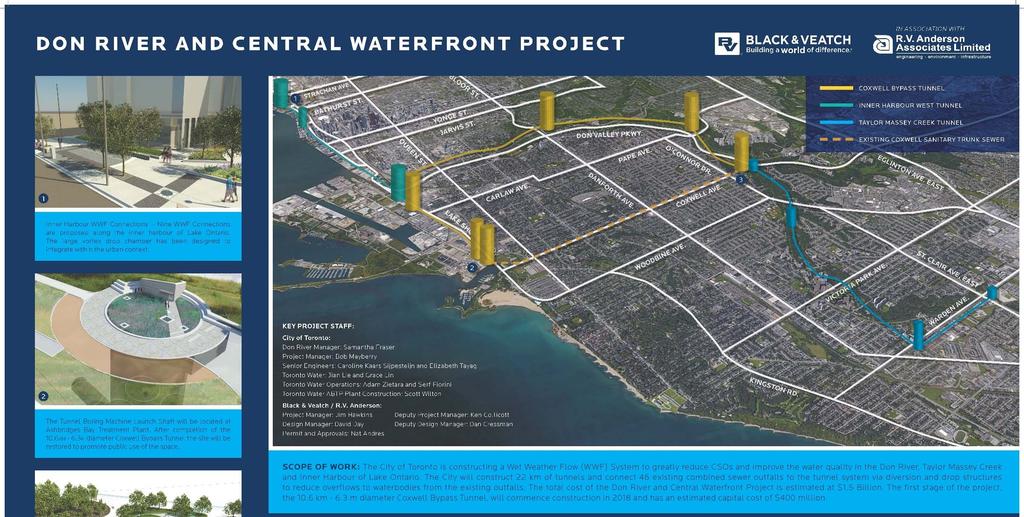
9 DON RIVER AND CENTRAL WATERFRONT PROJECT d Central Waterfront Project The new park will also house an underground vertical storage shaft as part of the Don River and Central Waterfront Project proposed by Toronto Water. The project is designed to virtually eliminate combined sewer overflows into Lower Don River and Toronto's harbour. The 15m diameter shaft will be constructed at a future date, however the new park design will account for this in the concept evaluation and final design proposal. The team will collaborate with Toronto Water through the design process to ensure that all technical requirements are met while Parks design vision and program goals and objectives are not compromised. The resulting new park design will be win-win for city departments and park users alike.

10
11 PROJECT SCHEDULE AND NEXT STEPS 2016 Environmental Investigations Stakeholder Consultation Request for Proposals for Design Services 2017 Public Consultation Preliminary Design Preferred Concept Site Remediation (as required) WE ARE HERE 2018 Detailed Design On going Site Remediation (as required) Construction tender WE WANT TO HEAR FROM YOU For more information about this project contact: Kate Nelischer Senior Public Consultation Coordinator Public Consultation Unit, City of Toronto Metro Hall, 55 John Street, 19th floor Toronto, ON M5V 3C6


12 SHARE YOUR IDEAS Activity #1 Idea Generation Park Design Collage Share your ideas by creating a collage. STEP 1: Think about what features you would like to see in a new park at 318 Queens Quay West, find them in the images on your table, and add them (glue/tape/) to your aerial map to create a collage. If you think of something that is not represented in the images, draw or write it in. STEP 2: Identify where you think park entrances/exits and pathways could be located: Use an X to mark entrances Use arrows to mark a pathway What's your vision for the new park at 318 Queens Quay West? What facilities and programming would you like to see included? Activity #2 Local Experts Community Mapping Wall Add your ideas to a collaborative community mapping wall to help identify local assets, barriers, and surrounding connections that are important to consider when designing the New Park at 318 Queens Quay West. The people who travel in, around, and through an area are the ones who know it best. How could a new park add to the waterfront park system? What local assets/amenities are nearby that could connect to the new park? What challenges could limit use of the new park? How can a new park be connected to the adjacent community context? North/South, East/West? How would a new park influence or change the way you visit and spend time on Toronto's Waterfront? What new park features/amenities would encourage four season use of the park?


13 SAMPLE IMAGES Landscape Features


14 SAMPLE IMAGES Hardscape Features


15 SAMPLE IMAGES Recreation


16 SAMPLE IMAGES Flexible Space


17 SAMPLE IMAGES Site Furnishings
Chairman and Members of the Planning and Development Committee. Thomas S. Mokrzycki, Commissioner of Planning and Building
 LA.09.TOR (Toronto) DATE: TO: FROM: SUBJECT: Chairman and Members of the Planning and Development Committee Thomas S. Mokrzycki, Commissioner of Planning and Building Central Waterfront Secondary Plan
Welcome. Community Consultation Meeting November 28, Review and discuss the Bathurst Quay Neighbourhood Plan Framework
 Welcome Community Consultation Meeting November 28, 2016 Why Are We Here Today? Review and discuss the Bathurst Quay Neighbourhood Plan Framework Review and discuss an Action Plan for Implementation Next
Thank you for coming to the Rail Corridor Land Use Study Public Meeting.
 01 Welcome! Thank you for coming to the Rail Corridor Land Use Study Public Meeting. Tonight is an opportunity to learn about the Land Use Study for the Rail Corridor Site. In Fall 2016, Toronto City Council
BATHURST QUAY NEIGHBOURHOOD PLAN IMPLEMENTATION. Streetscape & Public Realm Improvement Plan - Canada Malting Silo Site and Eireann Quay
 BATHURST QUAY NEIGHBOURHOOD PLAN IMPLEMENTATION Streetscape & Public Realm Improvement Plan - Canada Malting Silo Site and Eireann Quay Bryan Bowen, Waterfront Secretariat November 25, 2017 Presentation
Welcome! Rail Corridor Land Use Study Public Meeting #2
 Welcome! Rail Corridor Land Use Study Public Meeting #2 Tonight is an opportunity to learn about and provide input on the proposed planning framework and emerging directions for the Rail Corridor Site
DOWNTOWN PARKS & PUBLIC REALM PLAN
 DOWNTOWN PARKS & PUBLIC REALM PLAN CHALLENGES The Parks and Public Realm Strategy addresses challenges associated with a growing Downtown, including: GOALS 3.3 New buildings will fit within their existing
YorkCentre ICE Condominiums Public Art Plan York Street Block 9A Developments Limited / Block 9B Developments Limited
 YorkCentre ICE Condominiums Public Art Plan - 2009 16 York Street Block 9A Developments Limited / Block 9B Developments Limited 1 1. Introduction YORKCENTRE - ICE CONDOMINIUMS YorkCentre - ICE Condominiums
Queens Quay East & Lake Shore Boulevard East & 26 Richardson Street Public Art Plan
 STAFF REPORT ACTION REQUIRED 130-132 Queens Quay East & 143-177 Lake Shore Boulevard East & 26 Richardson Street Public Art Plan Date: April 20, 2016 To: From: Toronto East York Community Council Director,
350, 370, and 390 Queens Quay West Official Plan Amendment and Zoning Amendment Applications - Preliminary Report
 STAFF REPORT ACTION REQUIRED 350, 370, and 390 Queens Quay West Official Plan Amendment and Zoning Amendment Applications - Preliminary Report Date: April 22, 2016 To: From: Wards: Reference Number: Toronto
A 25-YEAR PLAN FOR DOWNTOWN
 A 25-YEAR PLAN FOR DOWNTOWN The Downtown Secondary Plan will provide policy direction to shape future growth and link that growth to the provision of infrastructure for liveability 1. BALANCING GROWTH
Bathurst Quay Neighbourhood Plan Interim Report
 STAFF REPORT ACTION REQUIRED Bathurst Quay Neighbourhood Plan Interim Report Date: June 8, 2017 To: From: Wards: Reference Number: Toronto and East York Community Council Director Community Planning, Toronto
Rail Deck Park - City-initiated Official Plan Amendment Final Report
 STAFF REPORT ACTION REQUIRED Rail Deck Park - City-initiated Official Plan Amendment Final Report Date: October 30, 2017 To: From: Wards: Reference Number: Toronto and East York Community Council Acting
Toronto Waterfront Revitalization
 Toronto Waterfront Revitalization Toronto Waterfront Revitalization Corp. Established 2001 Tripartite - Government of Canada, Province of Ontario, City of Toronto Master developer, comprehensive integrated
PRELIMINARY DESIGN + DEVELOPMENT PLAN
 WELCOME! To The Public Open House May 30 th, 2017 HARBOUR WEST PARKS Vision Project Overview The City s vision for Port Credit Harbour West Parks is to develop a vibrant waterfront destination that integrates
Coordinated Transit Planning in Toronto SmartTrack GO RER Scarborough Relief Line Waterfront Transit
 Coordinated Transit Planning in Toronto SmartTrack GO RER Scarborough Relief Line Waterfront Transit Public Information Centres February 2016 Transportation Planning Section City Planning Division Toronto
Cold Lake Marina Master Plan
 Cold Lake Marina Master Plan Intro to Team Moffatt & Nichol is recognized throughout the world for our role in the revitalization and redevelopment of urban waterfronts, including the evolution of modern
Presented by Catherine Williams, Public Art Consultant. In Attendance Neil Pattison, The Daniels Corporation. Introduction and Context
 Public Art Plan East Bayfront Precinct Daniels Waterfront: City of the Arts Complex 130-132 Queens Quay East & 143-177 Lake Shore Boulevard East & 26 Richardson Street Toronto, Ontario Presented September
Purpose of Open House #3
 Public Meeting #3 May 9, 2009 MVVA Team Purpose of Open House #3 The main purpose of this Open House is to present and seek input on the: Evaluation of transportation and infrastructure design alternatives
Parks Master Plan Implementation: Phase I Waterfront Use and Design REPORT #: September 7, 2016 File #
 0 'O DI Lan-171-14 1 - THE CORPORATION OF THE TOWN OF COBOURG..,. STAFF REPORT TO: FROM: Mayor and Members of Council Dean A. Hustwick, Director of Recreation and Culture DATE OF MEETING: Committee of
Public Meeting #3 May 9, 2009 MVVA Team
 Public Meeting #3 May 9, 2009 MVVA Team Welcome to the third Public Meeting for the Lower Don Lands Municipal Class Environmental Assessment (EA) Infrastructure Master Plan and Keating Channel Precinct
Rail Corridor Bathurst Street to Blue Jays Way - Official Plan and Zoning By-law Amendments Application - Preliminary Report
 STAFF REPORT ACTION REQUIRED Rail Corridor Bathurst Street to Blue Jays Way - Official Plan and Zoning By-law Amendments Application - Preliminary Report Date: June 1, 2017 To: From: Wards: Reference Number:
Naomi Weiss, Executive Director, DBPA Jason Jeffries, Project Manager, City of Daytona Beach
 Naomi Weiss, Executive Director, DBPA Jason Jeffries, Project Manager, City of Daytona Beach Nottingham Plan 2002 Adopted Redevelopment Plan 2002 Riverfront Action Plan 2004 Downtown Vision Plan 2007
DRAFT. Waterfronts and Open Spaces. 10 The Riverfront Open Space System
 CHAPTER 4 Waterfronts and Open Spaces 10 The Riverfront Open Space System 12 Planned, proposed and envisioned riverfront recommendations. Figure 4.3.23 The riverfront will become a major new public amenity
Sub-committee on Harbour Plan Review of Harbour-front Enhancement Committee. Ninth Meeting
 Sub-committee on Harbour Plan Review of Harbour-front Enhancement Committee Ninth Meeting Date: 5 October 2005 Time: 3:30pm Venue: Conference Room 15/F, North Point Government Offices, 333 Java Road, North
Workshop 3. City of Burlington Waterfront Hotel Planning Study. September 14, The Planning Partnership
 Workshop 3 City of Burlington Waterfront Hotel Planning Study September 14, 2017 The Planning Partnership The Waterfront Hotel Planning Study 01 The Brant & Lakeshore Planning Study will establish a Strategic
Reshaping The City: New Visions for Urban Transport. Trent Lethco, Associate Principal Allison Davis, Senior Planner Vicent Risica, Planner Arup
 Reshaping The City: New Visions for Urban Transport Trent Lethco, Associate Principal Allison Davis, Senior Planner Vicent Risica, Planner Arup Agenda Where are we now? Rethinking infrastructure? Cities
Bathurst Quay Neighbourhood Plan. Community Consultation Meeting November 28, 2016
 Bathurst Quay Neighbourhood Plan Community Consultation Meeting November 28, 2016 1 Tonight s Agenda Background A Neighbourhood Plan for Bathurst Quay An Action Plan for Success Policy Directions and Next
YORK STREET PARK Design Competition Brief >
 MAY 15 2018 // INNOVATIVE DESIGN COMPETITION YORK STREET PARK Design Competition Brief > 2 TABLE OF CONTENTS 1. INTRODUCTION 4 2. GOALS (FROM THE RFQ) 7 3. PROGRAM FOR YORK STREET PARK 8 3.1 Required Design
Maple Leaf Square 15 York Street Public Art Plan
 STAFF REPORT ACTION REQUIRED Maple Leaf Square 15 York Street Public Art Plan Date: December 17, 2007 To: From: Wards: Toronto East York Community Council Robert Freedman, Director, Urban Design Ward 28
Public Workshop #2 October , Welcome. Former Kingston Penitentiary & Portsmouth Olympic Harbour
 Public Workshop #2 October 12 + 13, 2016 Welcome Former Kingston Penitentiary & Portsmouth Olympic Harbour Cataraqui Golf and Country Club Portsmouth Avenue St. Lawrence College Sir John A. Macdonald Blvd
Summary of Results from the Toronto Planning Review Panel Meeting held June 10, 2017 Executive Summary
 Summary of Results from the Toronto Planning Review Panel Meeting held June 10, 2017 Executive Summary The Planning Review Panel is a representative group of Torontonians, made up of 28 randomly selected
The Planning Partnership Baird + Associates TCI Management Consultants Ltd. Plan B Natural Heritage Wills Consulting Engineers Poulos & Chung Limited
 Little Lake Master Plan The Planning Partnership Baird + Associates TCI Management Consultants Ltd. Plan B Natural Heritage Wills Consulting Engineers Poulos & Chung Limited May 26, 2009 Purpose of Study
Glendale Niagara District Plan. New Text
 Glendale Niagara District Plan New Text NIagara-on-the-Lake Committee-of-the-Whole September 10 2018 District Plans A District Plan is a proactive planning strategy intended to drive growth and economic
Town of Whitby Waterfront Parks and Open Space Master Plan Final Report, January 2016
 CMS 20-16 Attachment #1 Town of Whitby Waterfront Parks and Open Space Master Plan Final Report, January 2016 Table of Contents Waterfront Master Plan Study Overview i Introduction 1 Overall Waterfront
HUMBER BAY PARK PROJECT - BUILDING CONCEPT
 WELCOME 1 Humber Bay Park, with its system of trails, rugged shoreline, and dramatic views, is a unique and rare waterfront experience within the larger metropolitan Toronto area offering a place for quiet,
Workshop #3 June 13, 2016
 Downtown Ocoee Master Plan Workshop #3 June 13, 2016 Our Team Our Team and Tonight s Goal Quick Recap: Why a Downtown Plan? How are we developing the plan? How can you still be involved? What s left to
Table 8-4: Road Classification Local Roads, second table, of Chapter 8 Create a Multi-Modal City, be amended by adding the following:
 1 Port Street East Official Plan Amendment APPENDIX 3 Amendments to Mississauga Official Plan Table 8-4: Road Classification Local Roads, second table, of Chapter 8 Create a Multi-Modal City, be amended
City of Plattsburgh DRI: Downtown Streetscapes & Riverfront Access. Downtown Streetscape and Riverfront Access Design
 City of Plattsburgh DRI: Downtown Streetscapes & Riverfront Access Welcome Thank you for coming this evening. Agenda PART I - Project Context The Downtown Revitalization Program Our DRI Projects Other
Director, Community Planning, Toronto and East York District
 Lower Yonge Precinct Plan Update STAFF REPORT ACTION REQUIRED Date: October 16, 2012 To: From: Wards: Reference Number: Toronto and East York Community Council Director, Community Planning, Toronto and
SALEM FOREST RIVER PARK PRELIMINARY POOL AREA ASSESSMENT & MASTER PLAN STUDY. For the City of Salem
 SALEM PRELIMINARY POOL AREA ASSESSMENT & MASTER PLAN STUDY For the City of Salem 6-13-17 This process undertaken by Weston & Sampson is to outline preliminary ideas only of what possibilities exist for
edmonton.ca/ribbonofgreen #ribbonofgreen
 WHAT IS THE RIBBON OF GREEN? The Ribbon of Green is Edmonton s entire river valley and ravine system. The Ribbon of Green (2018) Project will provide strategic guidance for the southwest and northeast
Ashbridges Bay Erosion and Sediment Control Project
 Ashbridges Bay Erosion and Sediment Control Project Project Brief Overview Toronto and Region Conservation Authority, in partnership with the City of Toronto, intends to carry out remedial erosion control
Public Open House. Overview of the Downtown Plan Official Plan Amendment April 23, 2018
 Public Open House Overview of the Downtown Plan Official Plan Amendment April 23, 2018 1 A 25-Year Plan for Downtown To ensure growth contributes positively to Toronto s Downtown as a great place to live,
Central Waterfront Secondary Plan
 Central Waterfront Secondary Plan OPA 257 Adopted by Toronto City Council on April 16, 2003; further approved in part as OMB modified Decision/Order for the West delivered Don Lands on November in 2005
India Basin/Hunters Point Shoreline Community Workshop May 21, 2008
 India Basin/Hunters Point Shoreline Community Workshop May 21, 2008 Workshop Agenda Welcome Process Overview Context & Existing Conditions Presentation of Draft Concepts Land Use and Open Space Priorities
TREASURE ISLAND PHASE ONE PROJECTS PUBLIC ART PROJECT OUTLINE
 TREASURE ISLAND PHASE ONE PROJECTS PUBLIC ART PROJECT OUTLINE BACKGROUND (DEVELOPMENT PROJECT OVERVIEW) The Treasure Island Development is an approved 405-acre redevelopment project on Treasure Island
Envision Front Royal Workshop 1 of 2
 Envision Front Royal Workshop 1 of 2 September 12, 2013 Summary The Envision Front Royal project held the first of two public workshops on September 12, 2013. The purpose of the workshop was to evaluate
PORT LANDS ACCELERATION INITATIVE- PHASE 2 PORT LANDS PLANNING FRAMEWORK
 Re: ED14.9 PORT LANDS ACCELERATION INITATIVE- PHASE 2 PORT LANDS PLANNING FRAMEWORK Toronto Film, Television and Digital Media Board June 10, 2016 2016-06-10-1 THE PORT LANDS TODAY CARLAW AVENUE CHERRY
New York City, 17 th c.
 Mannahatta New York City, 17 th c. Lower Manhattan, circa 1930s Westside Highway, Manhattan, circa 1940s Greenpoint Terminal Market, Brooklyn VISION 2020 NEW YORK CITY COMPREHENSIVE WATERFRONT PLAN
King-Spadina Secondary Plan Community Consultation Meeting. Michelle Knieriem, City Planner October 11, 2017
 King-Spadina Secondary Plan Community Consultation Meeting Michelle Knieriem, City Planner October 11, 2017 Agenda 6:30 Welcome 6:35 Presentation 7:15 Question and Answer Session 8:15 Closing Remarks HOW
planning toronto s downtown Parks and Public Realm Plan Request for Proposals Information Meeting Andrew Farncombe, Project Manager August 19, 2015
 planning toronto s downtown Parks and Public Realm Plan Request for Proposals Information Meeting Andrew Farncombe, Project Manager August 19, 2015 BATHURST ST Keeping Downtown a great place to live, work,
CHAPPLES PARK MASTER PLAN
 CHAPPLES PARK MASTER PLAN Presentation of Preliminary Development Options Public Open House #2 Wednesday November 2 nd, 2016 TONIGHT S AGENDA 1. Welcome & Introductions 2. Presentation by Sierra Planning
PUBLIC SPACE/AMENITY PROJECTS
 BUFFALO S LWRP 49 A1. Black Rock Canal Park Improvements Erie County Parks Black Rock Canal Park, Ontario and Niagara Street intersection PROJECT DESCRIPTION: Erie County s Black Rock Canal Park is 4.25
Glendale Niagara District Plan
 Glendale Niagara District Plan Planning and Economic Development Committee September 5 2018 District Plans A District Plan is a proactive planning strategy intended to drive growth and economic prosperity
Baselands Trails Master Plan Public Meeting. April 28, 2015 Fire Academy, 895 Eastern Avenue, Toronto 6:30 p.m. to 9:00 p.m.
 Baselands Trails Master Plan Public Meeting April 28, 2015 Fire Academy, 895 Eastern Avenue, Toronto 6:30 p.m. to 9:00 p.m. Baselands Trails Master Plan Meeting Purpose To present and get feedback on:
Hamilton Pier 7&8 Public Meeting and Workshop #1
 Hamilton Pier 7&8 Public Meeting and Workshop #1 May 12, 2015 May 01, 2015 Meeting Agenda 6:30 Doors Open 6:30-6:45 Review Boards 6:45-7:10 Introductions and Presentation Study Overview Policy Background
preliminary master plan Cover Slide executive summary public presentation
 preliminary master plan public presentation executive summary Cover Slide {agenda} + Master Plan Process + Context and Overviews + Preliminary Concepts - Entry/Gateways - Core District - Streetscape +
Highest & Best Use Study Marina Park Lands
 Executive Summary of Report MARCH 2006 TABLE OF CONTENTS 1. Introduction...1 2. Study Process...2 3. Highest And Best Use Program...3 4. Concept Plan...8 5. Public Area Animation...9 6. Marina Park Implementation
Artist s Concept. Berry Road and Stephen Drive, South Etobicoke FOR LEASE. Occupancy Fall Mixed-Use Development Built and Leased by
 Berry Road and Stephen Drive, South Etobicoke FOR LEASE R E TA I L S P A C E O P P O R T U N I T Y Occupancy Fall 2017 Mixed-Use Development Built and Leased by DOWNTOWN T.O. BILLY BISHOP AIRPORT QEW HUMBER
TH E U N IVE RSIT Y O F FLO R I DA LANDSCAPE MASTER PLAN REPORT
 TH E U N IVE RSIT Y O F FLO R I DA LANDSCAPE MASTER PLAN REPORT O C T O B E R 2 018 THE UNIVERSITY OF FLORIDA LANDSCAPE MASTER PLAN REPORT OCTOBER 2018 prepared by: CRJA-IBI Group GAI Community Solutions
{Best Practices. Summary of Tools, Strategies and Best Practices from 11 Michigan Case Study Communities
 Case Studies Michigan Coastal Community Working Waterfronts { Summary of Tools, Strategies and from 11 Michigan Case Study Communities Table of Contents Zoning...2 Community and Stakeholder Collaboration
Johnson Street Bridge Public Realm Update
 Johnson Street Bridge Public Realm Update August 20, 2015 Background Johnson Street Bridge Replacement Project impacts a diverse range of stakeholders In addition to a new bridge, the project also includes
10 Park Lawn Rd - Zoning Amendment Application- Preliminary Report
 STAFF REPORT ACTION REQUIRED 10 Park Lawn Rd - Zoning Amendment Application- Preliminary Report Date: March 9, 2012 To: From: Wards: Reference Number: Etobicoke York Community Council Director, Community
G. RECREATION AND OPEN SPACE ELEMENT. The following summarizes the Recreation and Open Space Element:
 G. RECREATION AND OPEN SPACE ELEMENT The purpose of the Element is to provide the framework and direction for a comprehensive system of public and private sites for recreation, including, but not limited
38 Queen s University Campus Master Plan Part 1
 38 Queen s University Campus Master Plan Part 1 46 The Campus at the City Scale Chapter 4 The Campus at the City Scale 39 Queen s is an urban University centrally located in Kingston. Decisions made by
Public Consultation Summary: Lakeview Place Making Workshop January 30, 2008.
 Page 1 of 11 Public Consultation Summary: Lakeview Place Making Workshop January 30, 2008. 1.0 Introduction: On January 30, 2008 the City of Mississauga, in conjunction with the consulting team of Brook
The ParksPlan is not focused on Recreation programs and services, nor is it a recreation
 1 The ParksPlan is not focused on Recreation programs and services, nor is it a recreation facilities master plan. The Recreation Service Plan, which is currently in progress, focuses on recreation programs
Table of Contents. Executive Summary... vii
 Table of Contents Executive Summary... vii Section I: Background...1 Introduction... 3 Study History... 3 Purpose and Role of the Plan... 6 Plan Organization... 7 The Estuary Shoreline... 11 Multiple Jurisdictions...
City of St. Thomas New Official Plan
 City of St. Thomas New Official Plan Sustainable & Healthy Community Workshop Ann Joyner and Paddy Kennedy Dillon Consulting Limited Work Shop Outline Introduction Presentation Exercise 1 (individual)
Toronto East York Community Council. Robert Freedman, Director, Urban Design
 STAFF REPORT ACTION REQUIRED The Burano Public Art Plan, 832 Bay Street Date: August 6, 2008 To: From: Wards: Reference Number: Toronto East York Community Council Robert Freedman, Director, Urban Design
Parks Plan Overview. City of Toronto Parks, Forestry and Recreation Division
 Parks Plan Overview City of Toronto Parks, Forestry and Recreation Division 1 In February 2010 Council approved the development of a five year plan to guide the acquisition, development, management and
Comparing the Design of Two Yaletown Open Spaces:
 Comparing the Design of Two Yaletown Open Spaces: An Evaluation of Design Elements and the Physical Environment Copyright Andrew Sherstone, 2011 A report submitted to the School of Urban and Regional Planning
Port Lavaca Future Land Use
 Port Lavaca Future Land Use Introduction The City of Port Lavaca is beginning to see sustained growth, after many years of relative stable population. New single family homes, apartments, and businesses
North Adelaide Playspace and Pocket Orchard
 The Adelaide City Council invites engagement from the community about Playspace and Pocket Orchard Project Summary Adelaide City Council invites feedback from the community on the Tidlangga (Park 9) Playspace
Relief Line Project Assessment
 6/9/2015 Relief Line Project Assessment Stakeholder Advisory Meeting #2 June 9, 2015 Meeting Purpose Report on the Evaluation Results for Potential Station Locations Seek your Input on Potential Corridors
CONSULTATION SUMMARY. Public and Online Consultation #1
 CONSULTATION SUMMARY Public and Online Consultation #1 On December 4, 2013 the Ministry of Tourism, Culture and Sport launched the first public consultation for the urban park and waterfront trail at Ontario
Waterfront Project VISION, GOALS AND OBJECTIVES
 Waterfront Project VISION, GOALS AND OBJECTIVES INTRODUCTION The City of North Vancouver created the Waterfront Project in 2005 in order to provide a focus for waterfront redevelopment opportunities and
- Document 2 - Algonquin Interpretation and The Continuing Conversation toward a Vision for a Revitalized Lansdowne
 140 - Document 2 - Algonquin Interpretation and The Continuing Conversation toward a Vision for a Revitalized Lansdowne On May 4, 2012, the City of Ottawa participated in a Forum with a number of Elders,
ARCHITECTURAL ALLIANCE LANDSCAPE WINTER
 ARCHITECTURAL ALLIANCE LANDSCAPE WINTER 2015 COMPANY PROFILE Formed in 1991, Architectural Alliance Landscape is a mid-sized firm in business in South Florida for over 24 years. Our goal is to bring new
Transportation Master Plan Environmental Assessment
 Transportation Master Plan Environmental Assessment AUGUST, 2014 Waterfront Toronto / Perkins + Will Lower Yonge Transportation Master Plan Environmental Assessment Contents Executive Summary 1 1 Introduction
Canadian Consulting Engineering Awards 2016 Queens Quay West Revitalization. Category B: Transportation
 Canadian Consulting Engineering Awards 2016 Queens Quay West Revitalization Category B: Transportation April 2016 Arup Contents Online Submission Confirmation Receipt Entry Consent Form Project Information...1
IMAGINE CLEARWATER. Community Workshop 3. November 2016
 IMAGINE CLEARWATER Community Workshop 3 November 2016 Imagine Clearwater has been a 6-month community-focused process to re-envision the downtown waterfront. VISIONING FRAMEWORK MASTER PLAN HOW CAN WE
03 HIGH PRIORITY SITES
 03 HIGH PRIORITY SITES HOWARD PARK Howard Park is one of South Bend s largest riverfront parks, hosting nearly acres. Howard Park has a very passive landscape with a recreation building, ice skating rink,
Bloor Street East Potential Ravine Portal Overlook and Access Passage to the Rosedale Valley and Don River Valley Ravine, Toronto, Canada
 TRANSFORMATIVE IDEA 2. GREAT STREETS Bloor Street Christie Pits Park Bloor St Spadina Ave Bathurst St Shaw St 1 Recognize the significant public realm improvements along Bloor Street and extend and enhance
Provide and maintain sufficient public parks, recreation facilities, and open space to meet the recreational needs of County residents and visitors.
 (ROS) Goal Provide and maintain sufficient public parks, recreation facilities, and open space to meet the recreational needs of County residents and visitors. OBJECTIVE ROS.01 The County shall acquire,
LOCATION IS EVERYTHING
 GROW WITH US Your future is here. We ve planned for it. Our Economic Development Strategy Prosperity 2020 - embraces diverse opportunities, built within a framework supported by by a skilled and educated
METROPOLITAN COUNCIL 390 North Robert Street, St. Paul, MN Phone (651) ; TDD (651)
 ; TDD (651)") DATE: December 20, 2011 METROPOLITAN COUNCIL 390 North Robert Street, St. Paul, MN 55101 Phone (651) 602-1000; TDD (651) 291-0904 TO: Metropolitan Parks and Open Space Commission FROM: Tori Dupre, Senior
DATE: December 20, 2011 METROPOLITAN COUNCIL 390 North Robert Street, St. Paul, MN 55101 Phone (651) 602-1000; TDD (651) 291-0904 TO: Metropolitan Parks and Open Space Commission FROM: Tori Dupre, Senior
5 Eireann Quay Site Plan Control Application
 STAFF REPORT ACTION REQUIRED 5 Eireann Quay Site Plan Control Application Date: March 12, 2015 To: From: Wards: Reference Number: Toronto and East York Community Council Director, Community Planning, Toronto
Town Centre Park Master Plan Update - Terms of Reference
 CoQuitlam For Committee Our File: 12-6100-20/14-001/1 Doc#: 2176441.V7 To: From: Subject: For: City Manager General Manager Parks, Recreation & Culture Services Town Centre Park Master Plan Update - Terms
Presentation Overview
 DETROIT RIVER INTERNATIONAL CROSSING STUDY Presentation to Windsor Rotary Club October 23, 2006 1 Presentation Overview 1. Overview 2. Progress Update Technical Work Program Environmental Work Program
AMBLESIDE WATERFRONT
 Overview: An Integrated Vision for the Waterfront The waterfront concept plan shown above is the result of 40 years of acquiring, planning and improving a publicly-owned waterfront. Consistent community
TAHOE CITY VISION PLAN June 2012
 TAHOE CITY VISION PLAN June 2012 Tahoe City Public Utility District North Lake Tahoe Resort Association Sustainable Community Advocates Agenda Process Overview Purpose TRPA Regional Plan Update Conversations
BRADENTON RIVERWALK EXPANSION MASTER PLAN
 BRADENTON RIVERWALK EXPANSION MASTER PLAN INTRODUCTION & AGENDA Process Update Community Engagement Summary Center for Active Design (CfAD) Recommendations Context and Existing Conditions Master Plan Alternatives
Chelsea Creek Municipal Harbor Plan
 Chelsea Creek Municipal Harbor Plan Public Meeting #1 June 11th, 2018 1 Presentation outline I. Introduction: Why are we doing this plan? II. Evolution of Chelsea Creek III. State of Chelsea Creek IV.
5.0 P A R K R E C O M M E N D A T I O N S
 5.0 P A R K R E C O M M E N D A T I O N S 5.1 Confederation Park The analysis of Confederation Park recognizes that it, along with City Hall, is the symbolic heart of Kingston. While the existing layout
Riverfront Development Plan
 Planning Studies Project Overview: Continuity Developing Fort Myers underused riverfront was the final step in Downtown redevelopment. To mine all facets of the riverfront, the Plan had to be created cohesively
01 Welcome! About Ontario Shores
 01 Welcome! Thank you for participating in the Master Planning Open House. Ontario Shores Centre for Mental Health Sciences is in the process of preparing a Master Program and Master Plan for submission
The Master Plan Framework
 The Master Plan Framework The East Harbour Master Plan advances the development of 60 acres of former industrial lands east of the Don River. The Master Plan outlines a vision for a vibrant, transit-oriented
NORTH CLAYMONT AREA MASTER PLAN COMMUNITY WORKSHOP #1 FEBRUARY 3, 2016
 NORTH CLAYMONT AREA MASTER PLAN COMMUNITY WORKSHOP #1 FEBRUARY 3, 2016 1. Introduction To the team and to the Plan Planning Partners The Claymont Community WILMAPCO New Castle County Claymont Renaissance
Citizen Engagement for a Sustainable Built Environment
 Citizen Engagement for a Sustainable Built Environment Examples and Case Studies from Michigan Communities Genesee County Metropolitan Planning Commission 10 th Annual Planning Forum October 23, 2015 Wayne