Northern Neighborhood Phase Two:
|
|
|
- Ashlynn Houston
- 6 years ago
- Views:
Transcription

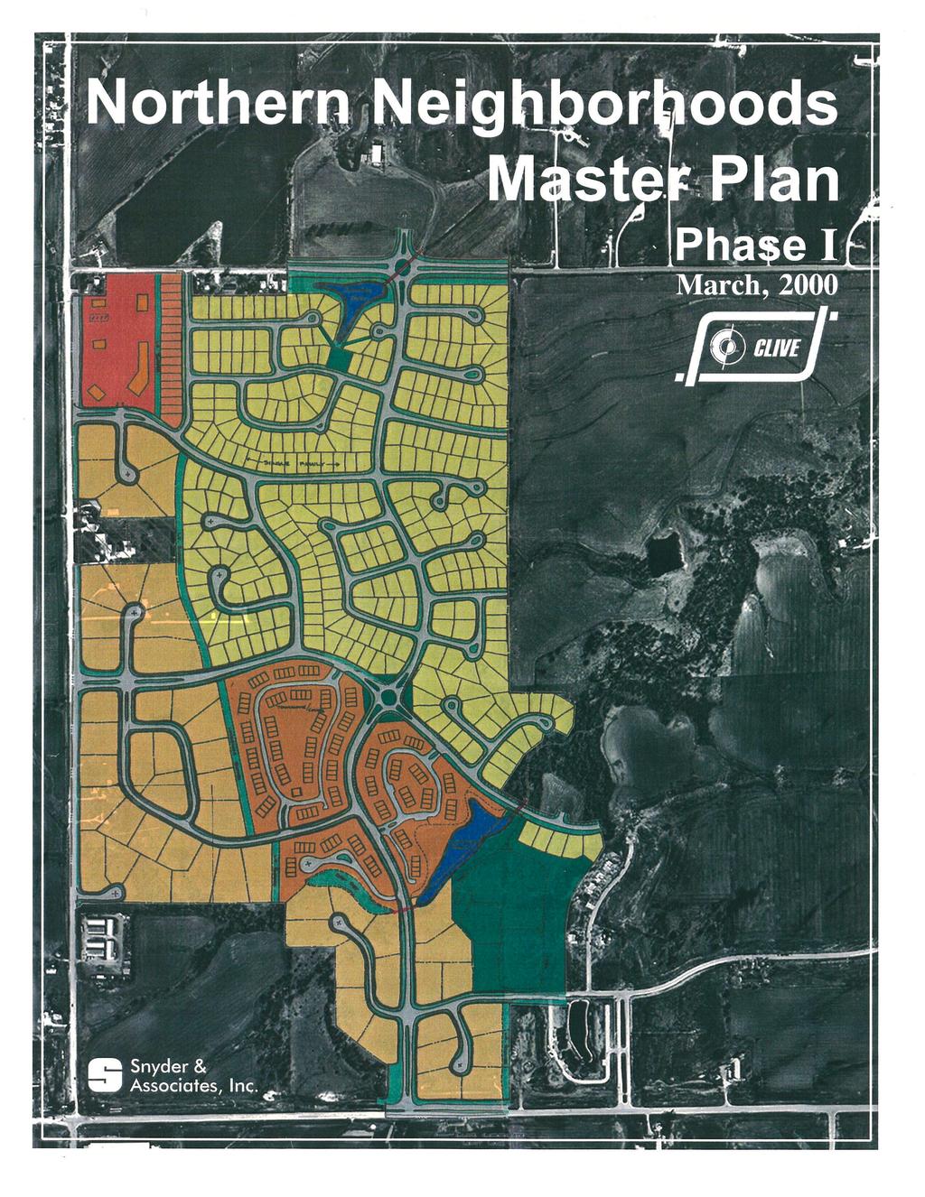
1 Northern Neighborhood Phase Two: City of Clive Community Development
2 Northern Neighborhoods Master Plan Phase II Approved by Clive City Council: March 27, 2003 Prepared by: City of Clive Community Development Department 1900 NW 114 th Street Clive, Iowa 50325
3 Table of Contents I. Introduction II. III. IV. Methodology Description of Area and Existing Conditions Proposed Development Plan V. Proposed Development Costs
4 I. Introduction The Northern Neighborhood Master Plan was introduced to the City of Clive in the most recent version of the City s Comprehensive Plan. Adopted on April 30, 1998, the Comprehensive Plan illustrated the first strategy for development of the newly annexed land in western Clive. Since then, the development models outlined in the Comprehensive Plan have been applied to the residential and commercial growth projected in this area. No fewer than eighteen separate landowners control property in the study areas. Thus, the idea for the Northern Neighborhood Plan was borne through a need to unite these individuals under a shared plan that will direct growth in an integrated and cohesive manner. Phase One of the Northern Neighborhood Master Plan was developed by Snyder and Associates in cooperation with City Staff and the affected property owners. The Planning and Zoning Commission reviewed the concepts and the City Council approved the plan on August 3, A copy of the Northern Neighborhood Phase One Land Use Plan is provided as an appendix to this document. Following Council direction, City staff has undertaken the development of Phase Two of the Northern Neighborhood Master Plan. This document represents a consensus among the affected property owners and the City. The Phase Two plan will be presented to the Planning and Zoning Commission for review and approved by the City Council as an amendment to the 1998 Comprehensive Plan. II. Methodology The purpose of this document is to present the background, rationale, and specific details for the land uses that are delineated in the Phase Two plan. The first section of this document supplies an inventory of existing conditions on this site. Included are examinations of topographical features, as well as current land uses. The second section includes an extensive analysis of the proposed land uses and street classifications, as well as, an evaluation of the proposed trails and parks. This document reflects a conceptual design and it is, therefore, dynamic and subject to some modification. For example, the primary collector running through the plan could be moved east or west to accommodate a stronger development layout or a more free-form design could be utilized in the townhome developments. Additionally, the higher density land uses have been shown as areas rather than as specific developments as the overall land area dedicated for the use and actual design of the neighborhoods will likely evolve as specific concepts are developed by the landowners. However, the City believes that the proposed land applications, and their component standards as described in this document, are accurate reflections of the desired development of this area. Therefore, not only does this document offer the best-case options for future land uses, it reflects an extrapolation of current City development strategies, as described in the Comprehensive Plan. III. Description of Area and Existing Conditions A. LEGAL/CORPORATE BOUNDARIES The Phase Two planning area, located generally between Alice s Road and Clive/Urbandale corporate limits, was annexed to the City of Clive in Generally described as the west ½ of Section 23, except Parcel B of the SW 1/4, of the SW 1/4, Township 79 North, Range 26 West (part of the Walnut Township in Dallas County), this property lies approximately 4 miles west of Interstate 35/80. The Phase Two planning boundary is bordered on the north and east by the Clive/Urbandale corporate boundary, to the west by Alice s Road and to the southwest by the Waukee corporate boundary. Page 1


5 WARD MEREDITH DR VERONA HILLS LC CERETTI GRATIAS VERONA HILLS LC ALICE'S RD GRUBB HERNDON DOUGLAS PKWY Ownership Map N
6 One large Waukee island is subtracted from the Clive corporate limits in the Phase Two planning area. Interjurisdictional complexities associated with an attempt to unify both Waukee and Clive territory under one plan could ultimately present design problems for the Master Plan, therefore, the Phase Two plan excludes the properties located in Waukee. B. PROPERTY OWNERSHIP Currently the property that lies within the Phase Two planning boundaries falls under the ownership of five property owners, as illustrated on the following Property Ownership exhibit. Each of the property owners has had an opportunity to review and comment on the Master Plan; however, primary attention was directed toward the major landowners: Verona Hills L.C., Tom Gratias, and Gerald Grubb. C. NATURAL FEATURES The property within the Master Plan generally slopes from the periphery toward a portion of the Little Walnut Creek, which runs through the middle of this area. The topography is generally rolling with more significant grade changes in the floodplain of the Little Walnut Creek. A review of the FIRM map for this area shows the limits of the 100-year Flood Plain and Floodway. The limits of the Floodplain are typically contained within 200 feet on either side of the creek. There are generous numbers of large, deciduous trees that exist along the periphery of the Little Walnut Creek and several existing ponds. Existing vegetation within the limits of the creek drainage way should be incorporated into the specific subdivision designs when possible. The Dallas County Soils Map identifies Canisteo-Clarion-Nicollet and Clarion-Webster- Storden Associations occupying the Phase Two planning area. These soils are generally considered well drained, typically including slopes of 2-5%. Slopes within the limits of the Little Walnut Creek floodway could be in the 14-18% range. Although relatively insignificant, there are pockets of wetlands along the periphery of the Little Walnut Creek as delineated by Snyder and Associations on September 9, 2002 (Wetlands Delineation Walnut Creek Sewer Route Dallas County, Iowa-Project NO ). D. EXISTING LAND USES In conformance with the City of Clive s policy for annexation, the property within the Phase Two planning area was zoned R-1 Single Family Residential when it was annexed. It is anticipated that these areas will be rezoned in the future at the request of the property owners. Approval of the rezonings shall be in accordance with the approved 1998 Comprehensive Plan and the Phase Two Northern Neighborhood Master Plan. As demonstrated on the following aerial photograph exhibit, the most active use of the property is currently farming and other agriculturally related activities. Several rural residential properties exist along the Alice s Road corridor, although a majority of those homes are located within the corporate limits of Waukee. In addition to the residential uses along Alice s Road, one commercial establishment was developed in the 1950 s, Alice s Spaghetti Land. The restaurant is presently open, however, the intent of the owner regarding the long-term continuation of the business is unknown. Page 2

7 WETLAND DELINATION WALNUT CREEK SEWER ROUTE SITE MAP- 9/9/02 Provided by Snyder & Associates (Project No ) Page 3
8 Redevelopment of the property in conjunction with surrounding property is likely the highest and best use for this property. Several residential homes have been constructed along Meredith Drive and will likely continue to be used as such. The Ward property on the east side of Alice s Road has been incorporated into the Phase Two plan for planning purposes because of its orientation, however, there is no intent to force the property owner into the presented development scheme. The City of Urbandale is currently in the process of updating their Comprehensive Plan for the area that is contiguous to the northern and eastern edge of the Phase Two plan. Despite the absence of a concrete plan for growth, Urbandale has indicated that the most likely land use will be single family residential with some limited commercial uses at the corner of NW 156 th Street and Meredith Drive. This assumption is substantiated by Urbandale s recent approval of several single-family residential plats. Waukee, occupying a portion of the west and southwestern boundary of the Phase Two plan, is also in the process of updating their Comprehensive Plan. Waukee staff has indicated a desire to commercialize all property along the Alice s Road corridor, as they intend to develop an interchange at the Alice s Road/Interstate 80 crossing. Additionally, it is likely that Waukee will permit substantial commercial construction to occur at the intersection of Alice s Road and Douglas Parkway/Douglas Parkway western extension. Property not adjacent to these arterial streets will likely be developed as residential. Page 4
9 MEREDITH DR ALICE'S RD WARD VERONA HILLS LC CERETTI GRATIAS VERONA HILLS LC GRUBB HERNDON DOUGLAS PKWY Zoning Map LEGEND R-1 FLOODWAY FLOOD FRINGE CREEK Boundary of floodway zoning district as shown is approximate. Actual floodway is defined on the most recent revisionof the flood insurance rate map as prepared by the Federal Emergency Managemen Agency (FEMA). N
10 IV. Proposed Development Plan A. LAND USES Enclosed within the roughly 300-acres described as Phase Two of the Northern Neighborhoods Master Plan are discrete land uses identified as the projected best-use scenario for the area. Specifically, Single-Family Residential, Townhome Residential, and Multi- Family Residential zoning classifications will be developed in accordance with the land use plan. The Land Use Plan map for the Phase Two plan is presented on the following page. As stated previously, the map represents a conceptual layout and land use plan illustrating the development intent for the area. Although individual lots and site-specific layouts have been shown, these items are only included to help address the intent or scale of the proposed land uses. The actual land use acreage, property boundaries, street locations, etc. of specific developments will be fully defined during the rezoning/development plan approval process. 1. SINGLE-FAMILY RESIDENTIAL (LOW DENSITY) As is shown in the 1998 Comprehensive Plan, the most prolific land use will be singlefamily residential. a. Zoning Single-family uses are facilitated through R-1 (Single-Family Residential) zoning. In some instances, R-2 (One and Two-Family Residential) may be allowed in order to provide a transition to the more intense residential uses. These smaller lots may be allowed on the portions of the single-family areas that abut Douglas Avenue and Meredith Drive. If R-2 zoning is used for this transition, the lots will be restricted to single-family residential rather than two-family residential. Additional uses permitted through the Zoning Ordinance include civic uses such as museums, libraries, and public and private schools. These special uses have not been incorporated into the Phase Two plan and will not be encouraged to develop in the single-family areas, primarily due to traffic concerns. b. Design Standards All structures in the single-family area of the Phase Two plan will be required to meet the bulk, setback, and buffering standards outlined in the applicable sections of the Zoning Ordinance and Design Standards Manual, and to the specific requirements of the Restrictive Covenants for the subdivision. While the regulations mentioned here will establish a minimum standard for all residential zones in the Phase Two plan, the City of Clive will encourage innovative and unique residential styles that provide a degree of continuity to the theme which has been established for the area. The front entrances should be the primary feature of the residences. The design for the homes should de-emphasize the garages by locating them at a greater setback than the front façade, and/or turning the garages away from the public street whenever possible. Developers of single-family uses in the Phase Two plan must be cognizant of the special development standards that impact some of the single-family lots. Specifically, single-family lots developed adjacent to Berkshire Parkway and/or roundabouts will require additional design considerations, as described in a following chapter. Page 5


11 Meredith Dr. 0 t a s a r R-4 R-1 Alice's Rd. Underpass/ Trail R-4 Greenbelt Park R-1 Proposed Round-a-bout Proposed Pedestrian Pathway Greenbelt Trail R-4 B e rk sh ire Pa Park rk w R-3 ay R-4 R-3 Douglas Ave. Northern Neighborhoods Phase Two City of Clive 800 Community Development Department n Proposed Round-a-bout
12 2. TOWNHOME RESIDENTIAL (MEDIUM DENSITY) Medium density townhome development will be permitted as shown on the Phase Two Plan. The town home areas generally represent the second ring, buffering the singlefamily residential uses from the potentially more intense commercial strip along Alice s Road and Douglas Avenue. Although townhomes are shown on the Phase Two plan, that would not preclude a property owner from developing the ground as single-family residential if desired. Regardless of the ultimate development intent, the City will emphasize high architectural standards. a. Zoning Development of townhome property will be done in accordance with the R-4 (Attached Dwelling) residential zoning district. The zoning district regulations permit a maximum of 8 dwelling units per acre. There has been some interest expressed by the land owners to include a singlefamily townhome use as a permitted use in the R-4 Zoning District. Based on acceptable design, density and infrastructure arrangements, the City may consider a Zoning Ordinance amendment which would allow this type of use. b. Design Standards All structures in the townhome area of the Phase Two plan will be required to meet the bulk, setback, and buffering standards outlined in the applicable sections of the Zoning Ordinance and Design Standards Manual, and to the specific requirements of the Restrictive Covenants for the subdivision. While the regulations mentioned here will establish a minimum standard for all residential zones in the Phase Two plan, the City of Clive will encourage innovative and unique residential styles that provide a degree of continuity to the theme which has been established for the area. The quality of construction materials is key, including the use of brick and architectural shingles. Private yards are required for any unit in this district. As with the single-family residential uses in the Phase Two plan, special attention to areas adjacent to Berkshire Parkway and/or roundabouts must be provided as outlined in a following section. 3. MULTI-FAMILY RESIDENTIAL (HIGH DENSITY) Encouraging either apartment style townhomes or condominium units, the residences constructed in this district will provide the highest density of housing in the Phase Two plan. The multi-family areas in the Phase Two plan are located north of Douglas Avenue and west of Berkshire Parkway. This use is intended to provide a buffer between the potential commercial activity on Douglas Avenue and Alice s Road and single-family residential to the northeast. a. Zoning Development of townhome property will be done in accordance with the R-3 (Multi- Family) residential zoning district. The zoning district regulations permit an approximate maximum density of 13.5 dwelling units per acre. Page 6
13 b. Design Standards All structures in the multi-family area of the Phase Two plan will be required to meet the bulk, setback, and buffering standards outlined in the applicable sections of the Zoning Ordinance and Design Standards Manual, and to the specific requirements of the Restrictive Covenants for the subdivision. While the regulations mentioned here will establish a minimum standard for all residential zones in the Phase Two plan, the City of Clive will encourage innovative and unique residential styles that provide a degree of continuity to the theme which has been established for the area. The architectural design of the facades and rooflines will be carefully scrutinized in order to mitigate the impact of the building scale (including garage structures) on the adjoining single-family structures. As the with single-family residential uses in Phase Two, special attention to areas adjacent to Berkshire Parkway and/or roundabouts, must be provided as outline in a following sections. B. PARKS FACILITIES The primary parks facility amenity in the Phase Two plan will be an extension of the Greenbelt. This linear park will extend along Little Walnut Creek from the Clive/Urbandale corporate limit line on the east through the neighborhood development. It is anticipated that the Greenbelt will continue west of Alice s Road in the Phase Three plan. Included in the Greenbelt, it is anticipated that the City will construct a 10 to 12-foot wide recreational trail. The trail will be a continuation of the trail segment proposed in the adjoining Urbandale development of Sticks and Stones. The Urbandale trail is envisioned to link to their regional park (Douglas Avenue and NW 142 nd Street) with a continuation back down to the Raccoon River Valley Trail / Clive Greenbelt Trail. In order to maximize the use of the proposed Greenbelt Trail, trailheads (including an 8-foot wide trail within a 15-foot wide easement) within the adjoining neighborhoods are envisioned. Proposed trailhead locations are shown in the Phase Two plan; however, the specific location and design will be determined at the time of preliminary platting. In addition to the Greenbelt Trail system, one neighborhood park is proposed in the Phase Two plan. The approximately 4-acre park is shown on the Grubb property, which would be dedicated as required by the recreational facilities dedication requirements of the Subdivision Code. The specific location of the park will be determined at the time of preliminary platting. Although not shown on the Phase Two plans, an approximately 6 acre neighborhood park (including a pond) is proposed in an adjoining development north of Little Walnut Creek in Urbandale. Additionally, the City has purchased approximately 20 acres immediately west of the Phase Two plan for park use. C. STREETS 1. ARTERIAL STREETS The Phase Two plan is bound by arterial streets along three sides- Alice s Road to the west, Douglas Avenue to the south and Meredith Drive to the north. It is the intent of the arterial streets to convey neighborhood and through traffic in the most efficient manner possible. To that end, limited access regulations along these corridors will be followed. Neighborhood streets will be permitted as shown on the Phase Two plan. Driveway Page 7
14 access for the R-3 and R-4 properties along these corridors will be restricted to 600-foot spacing. Alice s Road is a two-lane paved rural highway. The majority of this street lies within the Waukee corporate limits. There are currently no plans to improve Alice s Road; however, it is Waukee s intent to construct an interchange at the Alice s Road/I-80 intersection. At the time of platting, the developer will be required to dedicate 60-feet of right-of-way, measured east of the section line, for potential future improvements. At this time, the City has no plans to assess properties along Alice s Road for future improvements; however, the City does not waive its rights to do so in the future. As an alternative to an assessment agreement, the City may negotiate needed improvements in an amount equal to the anticipated current cost of the roadway improvements. Douglas Avenue will become an important artery for development in the Phase Two plan. Douglas Avenue, through Clive, currently exists as a two-lane gravel road. Future plans for this road include reconstruction as a four-lane boulevard. This requires that a 55-foot wide right-of-way, measured north of the section line, be dedicated at the time of final platting. This design corresponds with Urbandale s current plans for improving Douglas Avenue to the east. It is anticipated that Douglas Avenue would be constructed as an assessment project at the time improvements in Urbandale have been brought to the Clive corporate boundary. As an alternative to an assessment agreement, the City may negotiate needed improvements in an amount equal to the anticipated current cost of the roadway improvements. In addition to Douglas Avenue, Meredith Drive will be an important artery for this development. A majority of this street lies within the Urbandale corporate limits; therefore, the City will be taking the lead from Urbandale regarding street design and right-of-way needs. At this time Urbandale has indicated that Meredith Drive will be improved into a four-lane boulevard. To that end, the developer will required to dedicate 60-feet of right-of-way, measured south of the section line, for future improvements. It is anticipated that Meredith Drive would be constructed as an assessment project at the time improvements in Urbandale have been brought to the Clive corporate boundary. As an alternative to an assessment agreement, the City may negotiate needed improvements in an amount equal to the anticipated current cost of the roadway improvements. 2. PARKWAYS The first phase of the Northern Neighborhoods plan included the creation of two parkway streets. Berkshire Parkway, extending north from Highway 6, provides the primary entrance to the southern portion of the Phase Two plan. Projected to be a low-volume, slow speed roadway that encourages safe pedestrian and bicycle travel, these streets are intended to link the traveling public to the arterial roadways along the boundary of the plan. Berkshire Parkway will provide the primary entrance into the third phase of the Northern Neighborhoods Plan (approximately 700 acres west of Alice s Road). While serving as the principal vehicular route through the Phase Two plan, this Parkway will also contribute to an Old Town entryway theme for the residential and commercial areas of the Northern Neighborhoods by creating a pedestrian friendly corridor. To accomplish this theme, the City has adopted specific design standards for development along the Parkways. Page 8
15 a. Right-of-way To facilitate the placement of landscape buffering, Parkways will require a reduced right-of-way of 40-feet. The right-of-way will include a 26-foot b/b roadway, as well as sidewalks, pedestrian pathways, city utilities and street trees. The streets will be constructed of 7-inch thick reinforced p.c.c. No on-street parking is intended on either side of the Parkway. The 40-foot right-of-way will be expanded to allow for traffic roundabouts and roadway medians. A ten-foot Public Utility Easement will also be included in the plans for the Parkway where necessary to accommodate electrical, gas, telephone and cable services. This easement must lie outside the public right-of-way and the City Improvements Easements. b. Medians The Parkway plans two specific areas where roadway medians up to 20-feet wide and approximately 100-feet long will be created. Specifically, medians will be developed at the arterial intersections of Berkshire Parkway and Alice s Road and Douglas Avenue. c. Street Trees To further provide a pedestrian friendly environment to the Parkway design, 20-foot City Improvements Easements will be required on both sides of the Parkway rightof-way. These permanent easements will include provisions for city utilities, 4-foot public sidewalk, 8-foot pedestrian pathway, and landscaping. Within the City Improvements Easements, street trees will be required to be installed by the developer. The street trees will contain a planned mixture of shade and ornamental deciduous trees and evergreen materials. d. Setbacks Due to the reduced Parkway right-of-way width, the front yard setback shall be increased to 40-feet. This will provide a street setback of 47-feet, which would be identical to a standard R-1 lot along a typical public street. e. Residential Building Orientation With the exception of those homes that are adjacent to a traffic roundabout, all residential buildings must front to the Parkway. Included in this architectural orientation will be a front door, which will face the Parkway. In the case of townhome and condo/apartment development along the Parkway, site design will provide that the buildings have a primary orientation to front the Parkway. Buildings should be sited to minimize the field of parking/driveways between the Parkway and buildings. Parking structures shall not be permitted between the Parkway and buildings. f. Pedestrian Pathway/ Public Sidewalks The standard 4-foot pubic sidewalk will be constructed on the west side of the Parkway as shown in the Berkshire Parkway cross-section. To complement the Page 9
16
17 public sidewalk, an 8-foot wide pedestrian pathway will be constructed on the east side of Berkshire Parkway. The pathway will be designed to allow both pedestrian and low-speed bicycle traffic. The pathway will be curvilinear in alignment to accommodate the numerous tree plantings that will exist along the Parkways. g. Private Sidewalks All homes that front out to the Parkway will be required to include a 4-foot sidewalk from the front door to the public sidewalk/pedestrian pathway running along Berkshire Parkway. h. Lighting Parkway lighting is proposed to complement the Old Town theme created along this corridor. The gooseneck style lights that the City has selected include arms for the mounting of decorative banners. As has been completed through the Country Club Glen neighborhood along Boston Parkway, three streetlights per block are necessary: street corner- mid block-street corner. The decorative streetlights will be installed by the developer at the time of plat improvements. In addition, a private carriage light will be required at the sidewalk intersection with the public sidewalk/pedestrian pathway. The manufacture and model of the carriage light will be specified in the restrictive covenants for the development. i. Traffic Roundabouts To supplement the Old Town theme created by the Parkway corridors, the Parkway plan also includes the placement of two traffic roundabouts in the Phase Two plan. Designed to slow traffic flow without stopping traffic, these trafficcalming devices also provide unique landscaping and thematic functions. The Phase Two plan identifies traffic roundabouts at the intersections of Berkshire Parkway/Alice s Road and Berkshire Parkway/Douglas Avenue. The roundabouts require additional right-of-way to allow for the landscaped centerisland and for the actual paved roadway. The center-island will provide a 100-foot radius landscaping area. It is anticipated that the two roundabouts will be constructed as a Public Improvement at the time of construction of Alice s Road and Douglas Avenue widening. 3. INTERNAL STREETS The Phase Two plan identifies an internal street system that allows for a maximization of cul-de-sac development into the Greenbelt, while providing adequate through ways for orderly travel. Cul-de-sacs shall be permitted at a maximum rate of 2 per 40 acres of single-family residential ground. Private street cul-de-sacs within the R-3 and R-4 zoned property may have additional cul-de-sacs beyond the requirement above. Local public streets will be 26-feet wide, with 6-inch thick reinforced p.c.c. pavement. The right-of-way requirement for these streets shall be 60-feet wide. The right-of-way requirement for cul-de-sacs shall be a 76-foot radius. Page 10
18 All private streets will be required to be developed and constructed in accordance with the Urban Design Standards and Urban Standard Specifications for Public Improvements (including the Clive addendum). Public Utility Easements shall be provided outside of the right-of-way for use by private utility companies. 4. GENERAL All streets will be reviewed for capacity and operations at the time of preliminary platting. For example, it is likely that the internal streets intersecting the three arterial streets will be required to provide additional pavement for a right-turn lane out of the neighborhoods. Page 11
19 V. Proposed Development Costs The City is dedicated to maintaining a low tax rate. As a result, developers are required to contribute to the cost of providing infrastructure based on the increased development needs. The City has also established requirements for the dedication of recreational facilities based on the direct impact of future residential development. Although the City is requiring that the developer contribute to the cost of this development, the City will be a participant in the additional costs that are defined in the Phase Two plan. A. SANITARY SEWER HOOK-UP FEE 1. USSD/CITY OF CLIVE TRUNK SEWER The City and the Urbandale Sanitary Sewer District undertook a joint sanitary trunk sewer project during The trunk sewer extended along Walnut Creek from Hickman Road into the Dallas County portions of Clive and Urbandale. The proportionate share of that trunk sewer extension will be paid by the developer at the time of final platting. The cost of the proportionate share is equal to $1,800 per acre. 2. WALNUT CREEK TRUNK SEWER The City is currently in the process of constructing the Walnut Creek Trunk Sewer extension. The trunk sewer is the necessary extension of the USSD/Clive Trunk Sewer through the Phase Two plan. The sewer will extend along Little Walnut Creek from the Clive/Urbandale corporate limit to Alice s Road. The proportionate share of that trunk sewer extension will be paid by the developer at the time of final platting. The cost of the proportionate share will be based on the actual cost of construction- the current estimate is approximately $1,900 per acre. B. WATER MAIN HOOK-UP FEE 1. ALICE S ROAD WATER MAIN EXTENSION The City recently acquired capacity and constructed a 16-inch water main down Alice s Road from the Xenia/Urbandale/Des Moines Water Works main along Meredith Drive. The connection provides water service in the Phase Two planning area until the City s water distribution system is extended from the south. The developer will pay the proportionate share of the water capacity and main construction at the time of final platting. The cost of the proportionate share will be based on the actual cost of acquisition and construction- the current estimate is approximately $483 per residential unit. 2. WATER MAIN UP-SIZING The City is anticipating that a 16-inch water main is necessary along the Alice s Road corridor to accommodate the necessary water capacity needs in the northern distribution system. To that end, the City will be requiring the construction of a 16-inch water main to be constructed at the time of development along Alice s Road. The City will contribute to the incremental up-sizing cost (12 to 16 ) of the 16-inch water main. The incremental difference owed by the City will be offset against fees from other areas. Page 12
20 C. RECREATIONAL FACILITIES 1. PARKLAND DEDICATION The Subdivision Ordinance requires the dedication of parkland based on a proportionate share method. Currently, the requirement for parkland dedication is based on the impact of development (per 1,000 population created by number of units proposed) times the parkland multiplier. For example, a proposed 100-acre development with 200 singlefamily homes, 100 townhomes and 100 multi-family units would result in a parkland dedication requirement of 7.23 acres (200 Single-family units) X (persons per unit 2.7) = 540 persons (100 Townhome units) X (persons per unit 2) = 200 persons (100 Multi-family units) X (persons per unit 1.25) = 125 persons = 865 total persons (865 persons) / 1000 =.865 (.865) X (8.36 parkland multiplier) = 7.23 acres The required parkland dedication will be provided at the time of final platting. 2. PEDESTRIAN PATHWAYS The required 8-foot wide p.c.c. pedestrian pathway along Berkshire Parkway and Alice s Road will be a required public improvement (although the construction of the pathway will be completed at the time of the residential building construction). 3. GREENBELT TRAIL The Greenbelt Trail will be primarily located within the dedicated park ground along Little Walnut Creek, although portions of the trail will extend into the adjoining residential neighborhoods. The Greenbelt Trail and associated trail heads will be constructed by the City at the time of need and following construction of the trail in the Urbandale development- Sticks and Stones. The trailhead will be located within easements provided by the developer at the time of final platting. D. SUBDIVISION REVIEW FEE 1. The developer will be required to pay all fees associated with the Rezoning/Development Plan, Preliminary Plat, Construction Drawing, Final Plat and Site Plan review and filing fees as specified in the Subdivision Code and Zoning Ordinance. 2. The developer will be responsible for the cost incurred by the City for engineering services and legal services involved in the construction document review, construction observation and testing associated with the installation of all public utilities. Page 13
21
Planning Districts INTRODUCTION
 INTRODUCTION To facilitate detailed examination of development prospects for all areas of the community, Delano has been divided into 14 planning districts. The location of these planning districts is
Description of Preferred Alternative
 Chapter 2 Description of Preferred Alternative 2.1 Introduction This chapter of the programmatic Sammamish Town Center Sub-area Plan Final EIS provides a more detailed description of the Preferred Alternative
Section 9 NEIGHBORHOOD DESIGN
 Section 9 NEIGHBORHOOD DESIGN City of Lancaster Comprehensive Plan D u n k i n, S e f k o & A s s o c i a t e s, I n c. NEIGHBORHOOD DESIGN INTRODUCTION There are many ways in which a neighborhood can
BROOKHILL NEIGHBORHOOD MODEL ZONING MAP AMENDMENT PREFACE TO APPLICATION
 BROOKHILL NEIGHBORHOOD MODEL ZONING MAP AMENDMENT PREFACE TO APPLICATION June 15, 2015 Revised: August 1, 2016 I. VISION Brookhill is a proposed community based upon the principles of Albemarle County
ARTICLE 13 STREETS General
 ARTICLE 13 STREETS 13.1 General Streets shall be designed to suit their functions. Many streets have purposes other than vehicular traffic. As an alternative to current N.C. Department of Transportation
General Location Annex, Rezone & Preliminary Plat Lansdowne Addition, Unit Three
 NEWFOUNDLAND I-5 Agricultural District Subject Site SUNDANCE ANDERSON Single Family Residential CHRISTY PUD Agricultural District Highway Business General Location Annex, Rezone & Preliminary Plat Lansdowne
Applicant Name Phone / Fax / Address City State Zip Code . Property Owner Phone / Fax / Address City State Zip Code
 Master Development Plan Application Community Development Department City of Redmond 411 SW 9 th Street Redmond, Oregon 97756 541-923-7721 541-548-0706 FAX Master Development Plan Fee $38,862.52 File Number
2.0 AREA PLANS. Lakeside Business District. Lakeside Business District Land Use Categories:
 Lakeside Business District Lakeside Business District Land Use Categories: Campus Commercial Campus Commercial means a mixture of uses which includes corporate offices, office parks, hotels, commercial,
ARTICLE 13 STREETS General
 ARTICLE 13 STREETS 13.1 General Streets shall be designed to suit their functions. Many streets have purposes other than vehicular traffic. As an alternative to current N.C. Department of Transportation
Major Subdivision Sketch Plan Checklist
 This checklist provides specific requirements that are apart of the Sketch process. The entire process is described by the Huntersville Subdivision Review Process which details all the submittal and resubmittal
PLANNED UNIT DEVELOPMENT & SUBDIVISION STAFF REPORT Date: May 18, 2017
 & PUD-0000102-2017 PLANNED UNIT DEVELOPMENT & SUBDIVISION STAFF REPORT Date: May 18, 2017 NAME SUBDIVISION NAME Dauphin Creek Estates Subdivision Dauphin Creek Estates Subdivision LOCATION CITY COUNCIL
AWH REPORT OF THE PLANNING AND DEVELOPMENT DEPARTMENT FOR APPLICATION FOR REZONING ORDINANCE TO PLANNED UNIT DEVELOPMENT
 AWH REPORT OF THE PLANNING AND DEVELOPMENT DEPARTMENT FOR APPLICATION FOR REZONING ORDINANCE TO PLANNED UNIT DEVELOPMENT MAY 8, 2014 The Planning and Development Department hereby forwards to the Planning
ARTICLE 6: Special and Planned Development Districts
 ARTICLE 6: Special and Planned Development Districts 6-10 Traditional Neighborhood Development (TND) District 6-10.10 Purpose and Intent The Traditional Neighborhood Development (TND) District provides
O l so n M e morial Highway, S t e , G o l d e n V a l l e y, MN Delano Laketown Homes Concept Plan
 N O R T H W E S T A S S O C I A T E D C O N S U L T A N T S, I N C. 4 1 5 0 O l so n M e morial Highway, S t e. 3 2 0, G o l d e n V a l l e y, MN 5 5 4 2 2 T e l e p h o n e : 7 6 3. 9 5 7. 1 1 0 0 W
14 October 10, 2012 Public Hearing APPLICANT: MPB, INC
 14 October 10, 2012 Public Hearing APPLICANT: MPB, INC PROPERTY OWNER: MUNDEN & ASSOCIATES, LP STAFF PLANNER: Karen Prochilo REQUEST: Conditional Change of Zoning (AG-1 & AG-2 to Conditional O-2) ADDRESS
Standards (R-3) Figure B-11: R-3 Residential Standards Exhibit
 Figure B-11: R-3 Residential Standards Exhibit") Avila Ranch Avila Ranch Specific Plan Development Standards High Medium Density - High Residential Density Residential Lot and Building Lot and Standards Building (R-3) Standards (R-3) EXAMPLES These sketches
Avila Ranch Avila Ranch Specific Plan Development Standards High Medium Density - High Residential Density Residential Lot and Building Lot and Standards Building (R-3) Standards (R-3) EXAMPLES These sketches
PRELIMINARY PLAT DESIGN REQUIREMENTS Updated 4/8/2016
 PRELIMINARY PLAT DESIGN REQUIREMENTS Updated 4/8/2016 The following items are required for the preliminary plat. Numbers correspond with those on the example preliminary plat. RENO COUNTY SUBDIVISION REQUIREMENTS
KASPER. City of Georgetown, Texas PUD Planned Unit Development. December 30, 2015 Revised January 27, 2016
 KASPER City of Georgetown, Texas PUD Planned Unit Development December 30, 2015 Revised January 27, 2016 Applicant: Sentinel Land Company, LLC 4910 Campus Drive Newport Beach, CA Prepared by: SEC Planning
RESOLUTION NO R
 e e RESOLUTION NO R04 0054 BE IT RESOLVED by the Mayor and City Council ofthe City ofpapillion that The Papillion Comprehensive Plan is hereby amended to incorporate the Option A Future Land Use Map Transportation
Appendix D North Road/N. Leroy Street Subarea Plan
 North Road/N. Leroy Street Subarea Plan INTRODUCTION The City of Fenton Master Plan was updated in 1996 and included a subarea plan for the North Leroy Street area of the City. It was recognized at that
COLVER ROAD INDUSTRIAL CONCEPT PLAN
 COLVER ROAD INDUSTRIAL CONCEPT PLAN A CONCEPTUAL LAND USE AND TRANSPORTATION PLAN FOR TA-4 AN URBAN RESERVE AREA OF THE CITY TALENT City of Talent Adopted by City Council Resolution No., June, 2015 PART
RESIDENTIAL PLANNED UNIT DEVELOPMENT / SUBDIVISION AND REZONING CONCEPT AND DEVELOPMENT STAGE PLAN SUBMITTAL NARRATIVE
 RESIDENTIAL PLANNED UNIT DEVELOPMENT / SUBDIVISION AND REZONING CONCEPT AND DEVELOPMENT STAGE PLAN SUBMITTAL NARRATIVE DEVELOPMENT TEAM DONEGAL SOUTH Maple Grove, Minnesota March 27, 2017 Applicant/Developer/Builder:
SUBDIVISION, PLANNED UNIT DEVELOPMENT, PLANNING APPROVAL, REZONING & SIDEWALK WAIVER STAFF REPORT Date: February 7, 2013
 SUBDIVISION, PLANNED UNIT DEVELOPMENT, PLANNING APPROVAL, REZONING & SIDEWALK WAIVER STAFF REPORT Date: February 7, 2013 APPLICANT NAME SUBDIVISION NAME DEVELOPMENT NAME LOCATION S. E. Cemeteries of AL
Gold Line Bus Rapid Transit Transit Oriented Development (BRTOD) Helmo Station Area Plan
 Helmo Station Area Plan") Appendix F Gold Line Bus Rapid Transit Transit Oriented Development (BRTOD) Helmo Station Area Plan Introduction and Purpose of the Plan The Gold Line Bus Rapid Transit facility is an eleven-mile dedicated
Appendix F Gold Line Bus Rapid Transit Transit Oriented Development (BRTOD) Helmo Station Area Plan Introduction and Purpose of the Plan The Gold Line Bus Rapid Transit facility is an eleven-mile dedicated
Asbury Chapel Subdivision Sketch Plan
 Asbury Chapel Subdivision Sketch Plan PART 1: PROJECT SUMMARY Applicant: NVR Inc. Project Size: +/- 76.13 acres Parcel Numbers: 02101112,02116101,02116112, 02116113 Current Zoning: Transitional Residential
Chapter 5: Natural Resources and Environment
 NATURAL RESOURCES AND ENVIRONMENT 5-1 5 Chapter 5: Natural Resources and Environment BACKGROUND AND INTENT Urban expansion represents the greatest risk for the future degradation of existing natural areas,
Town of Portola Valley General Plan. Nathhorst Triangle Area Plan
 Town of Portola Valley General Plan Amended December 10, 1997 Table of Contents Introduction... 1 Planning Area... 1 Objectives... 2 Principles... 2 Standards... 4 Description... 4 Community Commercial...
Mitchell Ranch South MPUD Application for Master Planned Unit Development Approval Project Narrative. Introduction
 Mitchell Ranch South MPUD Application for Master Planned Unit Development Approval Project Narrative Introduction Mitchell Ranch South is a proposed single family (detached) residential development on
EXHIBIT B PROJECT NARRATIVE POULSBO MEADOWS
 EXHIBIT B PROJECT NARRATIVE POULSBO MEADOWS Name of Project: Poulsbo Meadows; A Planned Residential Development (PRD)/Plat Applicants Name: PBH Group LLC/Byron Harris PO Box 1010 Silverdale, WA 98038 Description
The transportation system in a community is an
 7 TRANSPORTATION The transportation system in a community is an important factor contributing to the quality of life of the residents. Without a sound transportation system to bring both goods and patrons
Mark-up of the effect of the proposed Bronte Village Growth Area OPA No.18 on the text of section 24, Bronte Village, of the Livable Oakville Plan
 Mark-up of the effect of the proposed Bronte Village Growth Area OPA No.18 on the text of section 24, Bronte Village, of the Livable Oakville Plan Notes: This document is provided for information purposes
North Oakville East Parks Facilities Distribution Plan. November, 2009
 North Oakville East November, 2009 POLICY CONTEXT 1) Purpose a) The purpose of this document is to be a guide for the location, configuration, design and development of the parks system for the North Oakville
CITY OF KEIZER MASTER PLAN APPLICATION & INFORMATION SHEET
 CITY OF KEIZER MASTER PLAN APPLICATION & INFORMATION SHEET PRE-APPLICATION CONFERENCE Prior to the actual filing of a Master Plan application, it is strongly recommended that the applicant contact Planning
Olde Towne Vision Plan
 Olde Towne Vision Plan Introduction In 2016, the City of Bellevue will complete its move of City offices from Olde Towne Bellevue to its new municipal complex on Wall Street. The City intends to sell its
AGENDA ITEM: IOWA. west] that were not FISCAL IMPACT. the City of Clive. STAFF REVIEW. Resolution II. Amendment PREPARED BY: REVIEWED BY:
![AGENDA ITEM: IOWA. west] that were not FISCAL IMPACT. the City of Clive. STAFF REVIEW. Resolution II. Amendment PREPARED BY: REVIEWED BY:](/thumbs/93/112428810.jpg "AGENDA ITEM: IOWA. west] that were not FISCAL IMPACT. the City of Clive. STAFF REVIEW. Resolution II. Amendment PREPARED BY: REVIEWED BY:") AGENDA ITEM: CITY OF WAUKEE, IOWA CITY COUNCIL MEETING COMMUNICATION MEETING DATE: March 7, 2016 AGENDA ITEM: Consideration of approval of a resolution approving Engineering Services Amendment No. 1 with
AGENDA ITEM: CITY OF WAUKEE, IOWA CITY COUNCIL MEETING COMMUNICATION MEETING DATE: March 7, 2016 AGENDA ITEM: Consideration of approval of a resolution approving Engineering Services Amendment No. 1 with
A BILL FOR AN ORDINANCE TO AMEND CHAPTER 9, KAUAI COUNTY CODE 1987, RELATING TO STREET REQUIRE:MENTS FOR SUBDIVISIONS
 ORDINANCE NO. BILL NO. { vy"yj1j A BILL FOR AN ORDINANCE TO AMEND CHAPTER 9, KAUAI COUNTY CODE 1987, RELATING TO STREET REQUIRE:MENTS FOR SUBDIVISIONS BE IT ORDAINED BY THE COUNCIL OF THE COUNTY OF KAUA'I,
Drexel, Barrell & Co.
 Drexel, Barrell & Co. June 18, 2018 Engineers/Surveyors Boulder Colorado Springs Greeley 3 South 7 th Street Colorado Springs, Colorado 80905-1501 719 260-0887 719 260-8352 Fax El Paso County Planning
COMMISSION ACTION FORM
 ITEM #: 6 DATE: 10-18-17 COMMISSION ACTION FORM REQUEST: Public Hearing on Proposed Amendments to the Ames Urban Fringe Future Land Map and Land Use Policy Plan for the North Growth Gap Area BACKGROUND
9 th Street Sub Area Plan
 9 th Street Sub Area Plan In the 1990 s, when the Township prepared the last Master Plan, the 9 th Street corridor was studied as part of a larger 9 th Street Focus Area that included the West Main Street
S o u t h C e n t r a l O u t l i n e P l a n. Leduc Business Park. North Leduc Industrial Area Structure Plan C it y of Led u c.
 Leduc Business Park North Leduc Industrial Area Structure Plan C it y of Led u c Prepared for Farm Air Properties Inc. January, 2007 Table of Contents Page Number 1.0 Purpose of Plan and Definition of
SYRINGA VALLEY SPECIFIC PLAN NARRATIVE
 SYRINGA VALLEY SPECIFIC PLAN NARRATIVE Introduction With this application, Pleasant Valley South LLC ( Pleasant Valley ) seeks the City of Boise s approval of a new Specific Plan Ordinance to be added
City of Grande Prairie Development Services Department KENNEDY DEVELOPMENTS LTD. OUTLINE PLAN OP-09-01
 City of Grande Prairie Development Services Department KENNEDY DEVELOPMENTS LTD. OUTLINE PLAN OP-09-01 July 27, 2009 TABLE OF CONTENTS 1.0 Introduction... 1 1.1 Plan Area Location & Context... 1 1.2 Ownership
Urban Design Brief. Watson Parkway North & Watson Road North Guelph, Ontario. Prepared by Coletara Development
 Urban Design Brief Watson Parkway North & Watson Road North Guelph, Ontario Prepared by Coletara Development December, 2013 Urban Design Brief, Coletara Development 1 Introduction This Urban Design Brief
Waukee. City of. The Key to Good Living
 Waukee City of The Key to Good Living City of Waukee FY15 - FY20 CIP Project Summary FY2015 FY2018 Parks Windfield Park Improvements Parks Centennial Park Amphitheater Parks Grant Park Improvements Parks
ARTICLE 17 SITE PLAN REVIEW
 ARTICLE 17 SITE PLAN REVIEW 17.01 INTENT AND PURPOSE The intent of this section is to provide for consultation and cooperation between the applicant and the township planning commission so that the applicant
OFFICE CONSOLIDATION SECONDARY PLAN AREA 22 THE BRAMALEA SOUTH INDUSTRIAL SECONDARY PLAN
 OFFICE CONSOLIDATION SECONDARY PLAN AREA 22 THE BRAMALEA SOUTH INDUSTRIAL SECONDARY PLAN November 2010 EXPLANATORY NOTES (Secondary Plan Area 22) General (pertaining to all secondary plan office consolidations)
Secrest Short Cut and Monroe Expressway Small Area Plan AUGUST 29, 2018
 Secrest Short Cut and Monroe Expressway Small Area Plan AUGUST 29, 2018 Background and Process Monroe Expressway will be open by the end of 2018 Union County and Indian Trail identified a need to revisit
City of Yelm. Tahoma Terra Final Master Plan Development Guidelines. Table of Contents
 City of Yelm Tahoma Terra Final Master Plan Development Guidelines Table of Contents Table of Contents... 1 Purpose... 2 Low Density Residential (R4-6)... 3 Moderate Density Residential (R6-10)... 5 Neighborhood
Baumgarten MPUD. Exhibit 3 Evaluation Criteria
 Pursuant to LDC subsections 10.02.13 B, 10.02.08 F and Chapter 3 G. of the Administrative Code, staff s analysis and recommendation to the Planning Commission, and the Planning Commission s recommendation
Drexel, Barrell & Co.
 Drexel, Barrell & Co. December 21, 2018 Engineers/Surveyors Boulder Colorado Springs Greeley 3 South 7 th Street Colorado Springs, Colorado 80905-1501 719 260-0887 719 260-8352 Fax El Paso County Planning
Preliminary Development Plan 07/ /2
 OWENSBORO METROPOLITAN PLANNING COMMISSION Preliminary Development Plan 07/06 120 1/2 Development Information The table at right refers to the application materials required for submission, unless otherwise
Palisades Outline Plan
 NE ¼ 25 36 28 W4 Town of Penhold Approved August 13, 2012 Contents Figures & Tables... 2 Introduction... 1 Overview... 1 Purpose... 1 Development Area... 3 Ownership... 3 Topography... 3 Existing & Surrounding
13. PRELIMINARY PLAT NO MILLS FARM - Vicinity of the southeast corner of 159 th Street and Quivira Road
 13. corner of 159 th Street and Quivira Road 1. APPLICANT: HNTB Corporation is the applicant for this request. 2. REQUESTED ACTION: The applicant is requesting approval of a preliminary plat for a 383-lot
Michael D, Harvey, Current Planning Supervisor. This project was originally approved in 2012 by the BOCC and is summarized as follows:
 PLANNING & INSPECTIONS DEPARTMENT Craig N. Benedict, AICP, Director Current Planning (919) 245-2575 (919) 644-3002 (FAX) www.orangecountync.gov 131 W. Margaret Lane Suite 201 P. O. Box 8181 Hillsborough,
Approved: CITY OF ARDEN HILLS, MINNESOTA PLANNING COMMISSION WEDNESDAY, AUGUST 5, :30 P.M. - ARDEN HILLS CITY HALL
 Approved: CITY OF ARDEN HILLS, MINNESOTA PLANNING COMMISSION WEDNESDAY, AUGUST 5, 2015 6:30 P.M. - ARDEN HILLS CITY HALL PLANNING CASES A. Planning Case 15-016; Final Planned Unit Development Arden Plaza;
PROPOSED BLOCK LENGTH CODE AMENDMENT
 10.426 Street Circulation Design and Connectivity. These standards are intended to assure that development will ultimately result in complete blocks bound by a network of public streets, and/or private
DEVELOPMENT FRAMEWORK POST 2030 LAND USE PLAN INTRODUCTION
 INTRODUCTION Oak Grove s Comprehensive Plan identifies a future Metropolitan Urban Service Area (MUSA). The Metropolitan Council does not anticipate extending utilities to this area prior to 2030. The
DRAFT Northeast Quadrant of Kipling Avenue and Highway 7 DRAFT AUGUST 29, Goals Land Use. The goals of this Plan are to:
 AUGUST 29, 2017 12.15 Northeast Quadrant of Kipling Avenue and Highway 7 12.15.1 Goals 12.15.2 Land Use The goals of this Plan are to: 12.15.2.1 General Provisions: a) Ensure the development of a compact
SITE PLAN REVIEW APPLICATION AND CHECKLIST
 SITE PLAN REVIEW APPLICATION AND CHECKLIST PROJECT SUMMARY: Project Name: City/ETA Location: City ETA (Application fee & number of copies needed are based on location) Property Location (Legal Description
COMMUNITY DESIGN. GOAL: Create livable and attractive communities. Intent
 COMMUNITY DESIGN Intent An attractive, well-designed County will attract quality development, instill civic pride, improve the visual character of the community, and create a strong, positive image for
ATTACHMENT A. SILVERDALE DESIGN STANDARDS Amendments to the Waaga Way Town Center Chapter
 ATTACHMENT A SILVERDALE DESIGN STANDARDS Amendments to the Waaga Way Town Center Chapter Chapter 10. Waaga Way Town Center 10.1 Physical Identity Elements & Opportunities The Waaga Way Town Center includes
RECREATION AND OPEN SPACE ELEMENT GOALS, OBJECTIVES, AND POLICIES
 RECREATION AND OPEN SPACE ELEMENT GOALS, OBJECTIVES, AND POLICIES Goal 7 To provide park facilities, recreation programs, and open space resources that are safe, adequate, and accessible to all City residents,
4.1.3 LAND USE CATEGORIES
 4.1.3 LAND USE CATEGORIES a. City Center District The City Center District incorporates the existing character and mix of uses in downtown Belmont to encourage redevelopment and new development in keeping
Planning Commission Staff Report March 15, 2007
 Planning Commission Staff Report Project: Request: Madeira East Tentative Subdivision Map, Design Review for Subdivision Layout & Abandonment of Easements Location: Phase IV of the Laguna Ridge Specific
CITY PLANNING COMMISSION AGENDA ITEM: C STAFF: ROBERT TEGLER FILE NO: CPC PUD QUASI-JUDICIAL
 CPC AGENDA June 8, 2006 Page 37 CITY PLANNING COMMISSION AGENDA ITEM: C STAFF: ROBERT TEGLER FILE NO: CPC PUD 05-294 - QUASI-JUDICIAL PROJECT: APPLICANT: OWNER: PARKWOOD AT WOLF RANCH NASS DESIGN ASSOCIATES
URBAN DESIGN BRIEF 305, 309, & 315 SOUTHDALE ROAD WEST LONDON ONTARIO
 URBAN DESIGN BRIEF 305, 309, & 315 SOUTHDALE ROAD WEST LONDON ONTARIO CARVEST PROPERTIES LTD. December 2013 Section 1 - Land Use Planning Context 1.1 Subject Lands The subject lands are located immediately
BOULEVARD AND PARKWAY STANDARDS
 88-323 BOULEVARD AND PARKWAY STANDARDS 88-323-01 PURPOSE Considerable public and private investment exists and is expected to occur adjacent to boulevards and parkways within the city. The following standards
Executive Summary. NY 7 / NY 2 Corridor
 Executive Summary NY 7 / NY 2 Corridor Transportation and Land Use Study December 2005 Prepared for: Town of Colonie Capital District Transportation Committee Prepared by: Introduction: Land use decisions
City of Grande Prairie Development Services Department
 City of Grande Prairie Development Services Department ROYAL OAKS NORTH OUTLINE PLAN OP-07-03 NW 35-71-6 W6M May 7, 2007 Royal Oaks North Outline Plan TABLE OF CONTENTS 1.0 INTRODUCTION........ 3 1.1 Purpose
WEST HILL BUSINESS PARK AREA STRUCTURE PLAN
 MUNICIPAL DISTRICT OF PEACE NO. 135 WEST HILL BUSINESS PARK AREA STRUCTURE PLAN Prepared by: TABLE OF CONTENTS 1.0 Introduction... 1 1.1 Purpose of Plan........ 1 1.2 Plan Area..... 1 1.3 Existing Conditions...
The Illinois Department of Transportation and Lake County Division of Transportation. Route 173, including the Millburn Bypass
 The Illinois Department of Transportation and Lake County Division of Transportation welcome you to this Public Hearing for U.S. Route 45 from Illinois Route 132 to Illinois Route 173, including the Millburn
PORT WHITBY COMMUNITY
 PORT WHITBY COMMUNITY SECONDARY PLAN UPDATE COMMUNITY IMPROVEMENT PLAN URBAN DESIGN GUIDELINES September 2015 DRAFT PROPOSED AMENDMENT NUMBER # to the Whitby Official Plan PURPOSE: The intent of this Amendment
for Master Planned Development Framework Design Standards & Guidelines
 B L A C K D I A M O N D DE S I G N G U I D E L I N E S for Master Planned Development Framework Design Standards & Adopted June 18, 2009 Introduction and Purpose The Master Planned Development (MPD) Framework
E. RURAL COMMERCIAL/INDUSTRIAL PARK MODEL
 E. RURAL COMMERCIAL/INDUSTRIAL PARK MODEL 1. PURPOSE The purpose of the Rural Commerce/Industrial Park Model is to provide parameters within which a grouping of business buildings with parking, loading
Chapter PEDESTRIAN COMMERCIAL (PC) ZONING DISTRICT
 ZONING DISTRICT") Chapter 11-17 PEDESTRIAN COMMERCIAL (PC) ZONING DISTRICT Sections: 11-17-01 GENERAL PURPOSE 11-17-02 PERMITTED BUILDING TYPES 11-17-03 USES PERMITTED WITH DESIGN REVIEW 11-17-04 USES PERMITTED BY CONDITIONAL
Chapter 11-17 PEDESTRIAN COMMERCIAL (PC) ZONING DISTRICT Sections: 11-17-01 GENERAL PURPOSE 11-17-02 PERMITTED BUILDING TYPES 11-17-03 USES PERMITTED WITH DESIGN REVIEW 11-17-04 USES PERMITTED BY CONDITIONAL
KEIZER STATION PLAN INTRODUCTION
 KEIZER STATION PLAN INTRODUCTION Planning for this area began in 1987 when the Keizer Comprehensive Plan established the Chemawa Activity Center and McNary Activity Center. The first Chemawa Activity Center
WASHINGTON COUNTY OREGON
 WASHINGTON COUNTY OREGON July 9, 2009 Revisions to Chapter 2 of the Bethany Community Plan The North Bethany Subarea Plan Exhibit pages 7 and 8 The sections for the Core and Flexible Streets were amended
LAND USE MEADOWS PLANNING AREA
 LAND USE MEADOWS PLANNING AREA I. Profile of Meadows Planning Area A. Location Meadows Planning Area is delineated by I-5 on the north, the Nisqually Bluffs representing the growth boundary on the east,
Community Development Rezoning Report REZ14-006
 Community Development Rezoning Report REZ14-006 Planning Commission Board of Supervisors March 4, 2014 March 26, 2014 Applicant M & N Real Estate, LLC Tax Map Id 125-(A)- L20E,125-(A)- L20E1, portion of
OP Council Resolution June 16, Planning and Development Services
 OP-08-01 Council Resolution June 16, 2008 Planning and Development Services Kingsgate Landing Outline Plan Table of Contents 1.0 Introduction 1 1.1 Purpose of Plan 1 1.2 Plan Area Location 1 1.3 Ownership
Dwelling Units Max 12 dwelling units per acre/min 8 dwelling units per acre. Development Mix 80% non residential/20% residential
 13. OSTEEN LOCAL PLAN Background: The Osteen Local Plan area is located in southwest Volusia County along the SR 415 corridor between Lemon Bluff Road and Acorn Lake Road and includes 3,990 acres. The
7.0 OPEN SPACE 7.1 OPEN SPACE DEDICATION CHAPTER 7: OPEN SPACE
 7.0 OPEN SPACE The intent of these requirements is to allow for the usage of centrally located unencumbered land as neighborhood open spaces and not to permit the use of leftover or otherwise unusable
Appendix E Preliminary Location Hydraulic Study
 Appendix E Prepared for: State of Alaska Department of Transportation and Public Facilities Prepared by: HDR Alaska, Inc. 2525 C Street, Suite 305 Anchorage, Alaska 99503 February 2014 This page intentionally
4.500 Preston Road Overlay District
 Section 4.500 Preston Road Overlay District 2004 Zoning Ordinance 4.500 Preston Road Overlay District (ZC 98-29; Ordinance No. 98-9-12) 4.501 Purpose To provide appropriate design standards for the use
PLANNING COMMISSION. Submitted
 PLANNING COMMISSION City Hall 1275 Main Street El Centro, CA 92243 Submitted PLANNING COMMISSION ACTION ITEM (1844) Meeting: 05/10/16 12:00 AM Department: Community Development Category: Public Hearing
Access Management: An Overview
 Figures 1-5 Below Evolution of development along a highway. In the early stages, land along the road is used for farming with little traffic generated. As time passes, the highway corridor becomes a de
Planned Residential Neighborhoods Land Use Goals
 Planned Residential Neighborhoods Land Use Goals Issue: Guidelines that provide for diverse high quality residential areas that include a variety of housing styles and layouts are needed. Goal 1: Create
MIDTOWN MIXED-USE VILLAGE. TECHNICAL DATA SHEET COMPONENT C-1 FOR PUBLIC HEARING - PETITION NUMBER Project No RZ1.1. Issued.
 N MIDTOWN MIXED-USE VILLAGE TECHNICAL DATA SHEET COMPONENT C- FOR PUBLIC HEARING - PETITION NUMBER 04-00 Project No. 496 Issued Revised SCALE: " = 0' N 0 0 0 40 RZ. c GENERAL PROVISIONS: a. SITE LOCATION.
Staff Report to the North Ogden City Planning Commission
 Staff Report to the North Ogden City Planning Commission SYNOPSIS / APPLICATION INFORMATION Application Request: Concept review on a legislative application to rezone land located at approximately 1750
LOS ANGELES CITY PLANNING DEPARTMENT STAFF REPORT
 LOS ANGELES CITY PLANNING DEPARTMENT STAFF REPORT LOS ANGELES CITY PLANNING COMMISSION CASE NO: CPC 2006-9374 CRA CEQA: Exempt DATE: December 21, 2006 Location: Valley Plaza and Laurel Plaza TIME: after
Policies and Code Intent Sections Related to Town Center
 Policies and Code Intent Sections Related to Town Center The Town Center Vision is scattered throughout the Comprehensive Plan, development code and the 1994 Town Center Plan. What follows are sections
SOUTH MAIN RIVER COMMUNITY REINVESTMENT PROJECT AREA PLAN DATED AUGUST 31, 2018
 SOUTH MAIN RIVER COMMUNITY REINVESTMENT PROJECT AREA PLAN DATED AUGUST 31, 2018 Redevelopment Agency of the City of Logan, Utah South Main River Community Reinvestment Project Area - 1 - INTRODUCTION 1.
Bylaw No. B-03/2011 Adopted by Airdrie City Council February 21, 2012
 COOPER S CROSSING STAGE 4 Neighbourhood Structure Plan City of Airdrie WESTMARK HOLDINGS LTD. Bylaw No. B-03/2011 Adopted by Airdrie City Council February 21, 2012 CONSULTANTS: LAND USE PLANNING: Southwell
MODEL ACCESS MANAGEMENT PLAN MINNESOTA TRUNK HIGHWAY 7 COMPREHENSIVE PLAN AMENDMENT (HUTCHINSON SEGMENT)
") MODEL ACCESS MANAGEMENT PLAN MINNESOTA TRUNK HIGHWAY 7 (HUTCHINSON SEGMENT) COMPREHENSIVE PLAN AMENDMENT INTRODUCTION. The purpose of this plan is to provide consistent access management in the Trunk
MODEL ACCESS MANAGEMENT PLAN MINNESOTA TRUNK HIGHWAY 7 (HUTCHINSON SEGMENT) COMPREHENSIVE PLAN AMENDMENT INTRODUCTION. The purpose of this plan is to provide consistent access management in the Trunk
II. SINGLE FAMILY RESIDENTIAL
 II. SINGLE FAMILY RESIDENTIAL Castle Rock is made up of numerous individually built houses and subdivision tracts that have been developed during the past century. Some of the tracts are diverse in architectural
Amendment to the Elderberry Neighborhood Development Plan
 Amendment to the Elderberry Neighborhood Development Plan Recommendations for Land Use, Transportation and Development July 13, 2018 City of Madison, Wisconsin Department of Planning and Community and
Central and East Neighbourhoods - Hermitage Outline Plan
 Central and East Neighbourhoods - Hermitage Outline Plan Office Consolidation September 2013 Prepared by: Planning and Policy Services Branch Planning and Development Department City of Edmonton The Central
CHAPTER 3. Design Standards for Business, Commercial, Industrial, Recreational and Institutional Uses
 CHAPTER 3 Design Standards for Business, Commercial, Section Number Title Ordinance Number Date of Ordinance 16-3-1 Applicability 2006-11 2008-04 07-01-08 16-3-2 Uniform Standards for Architectural Design
Urban Design Brief December 23, 2015 Southside Construction Group Official Plan & Zoning By-Law Amendment
 Urban Design Brief Proposed Official Plan & Zoning By-Law Amendment 3244, 3263 and 3274 Wonderland Road South Southside Group December 23, 2015 TABLE OF CONTENTS Page No. INTRODUCTION... 1 SECTION 1 LAND
SHEFFIELD PARK Paulding County, GA DRI #588
 SHEFFIELD PARK Paulding County, GA DRI #588 Supplemental Information for RDC s DRI (Form 2) Review August 16, 2004 Prepared for: Mr. David Howerin Coosa Valley RDC 1 Jackson Hill Drive Rome, GA 30161 P.O.