Conceptual Design Meeting. River Street and Western Avenue Bridge Rehabilitation Project
|
|
|
- Stephanie May
- 5 years ago
- Views:
Transcription
1 Monday, 6:30 PM - 8:00 PM Honan-Allston Branch Library 300 North Harvard Street Allston, MA
2 Patrick-Murray Accelerated Bridge Program 2009 Program Overview Authorization: Chapter 233 of the Acts of 2008 Program to be complete by 2016 Program Goals: Improve the Condition of the Commonwealth's Bridges Stimulate Economic Development and Job Creation Save Money by Completing Projects Sooner Complete Projects Efficiently and Innovatively Provide Access and Opportunity for all Manage with Transparency and Accountability
3 Patrick-Murray Accelerated Bridge Program Program Overview- 8 years only Size and Scope Former MassHighway: $2.078 billion rehabilitation or replacement of 189 bridges preservation of 305 bridges Former DCR: $906 million rehabilitation or replacement of 29 bridges preservation of 50 bridges MassDOT Total Program: $2,984,000,000
4 Agenda Review of the Patrick-Murray Accelerated Bridge Program Charles River Basin Overview Structural Rehabilitation Concept Traffic Bicycle/ Pedestrian Historical/ Cultural Considerations Question & Answer

5 Project Location Anderson Memorial Bridge NORTH Western Avenue Bridges River Street Bridges Craigie Drawbridge and Dam Bridge Longfellow Bridge B. U. Bridge
6 Bridge Rehabilitation Project Goals To repair the structurally deficient bridges to meet current and future multi-modal transportation needs and extend the life of the bridge, while preserving and rehabilitating the historical, cultural, and natural resources in the project area.
7 Proposed Rehabilitation Concept Design Goals and Parameters Design Goals Structural Maintain Historic Appearance, while upgrading bridge features to current codes and standards Repair Parapets and Spandrel Walls and the Arches Final Condition Multi-Use Facilities Three Vehicular Traffic Lanes Improve multi-modal facilities Construction Conditions Maintain two Vehicular Traffic Lanes Maintain Pedestrian and Bicycle access to the bridge Maintain two unobstructed navigation channels through the arches at all times

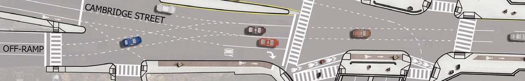
8 River Street Bridges BOSTON SOLDIERS FIELD ROAD CAMBRIDGE STREET CAMBRIDGE NORTH RIVER STREET BRIDGE MEMORIAL DRIVE RIVER STREET CHARLES RIVER


, Concrete More")

9 River Street Existing Conditions River Street Arch Bridge over Charles River Arch Barrels Widespread Spalling and Delamination of Concrete High Concentrations of Chloride Content which may promote Steel Reinforcement Corrosion Lack of Air-Entrainment (Common in 1920 s), Concrete More Susceptible to Freeze/Thaw effects Minor Alkali Silica Reactivity which will continue to accelerate in moist environment
 Separation of Ringstones from Arch Barrels (Up to 3 ) Deterioration of dowels anchoring")

10 River Street Existing Conditions River Street Arch Bridge over Charles River Arch Ringstones (Voussures) Separation of Ringstones from Arch Barrels (Up to 3 ) Deterioration of dowels anchoring Ringstones into Arch Barrels represent a falling hazard Widespread Deterioration of Ringstone Concrete Spandrel Walls Massive Gravity Retaining Walls Outward Movement Detected Widespread Deterioration of Concrete

 shows misalignment due to")


11 River Street Existing Conditions River Street Arch Bridge over Charles River Concrete Parapet and Sidewalk Parapet (Railing) shows misalignment due to movement of spandrel wall Parapet is not capable of resisting vehicular impact Sidewalk is un-reinforced and deteriorating Due to Spandrel Wall movement, Sidewalk cross-slope has deteriorated Abutments, Piers, Wingwalls Deterioration of timber piles supporting wingwalls causing settlement cracking Widespread Deterioration of Concrete Piers and Cutwaters

12 River Street Existing Conditions River Street Arch Bridge over Charles River Existing Cross-Section Above Existing Section through the Quarter Point of the Center Arch Left Existing Section through the south sidewalk near the Quarter Point of the Center Arch


13 River Street Proposed Rehabilitation Concept Design Goals and Parameters
14 River Street Proposed Rehabilitation Concept Final Elevation: River Street over the Charles River
15 River Street Proposed Rehabilitation Concept Final Cross-Section: River Street Arch Bridge over Charles River
16 River Street Proposed Rehabilitation Concept Final Cross-Section: River Street Arch Bridge over Charles River


17 Cambridge Street Existing Conditions Cambridge Street over Soldiers Field Road Concrete Tee Beams and Deck Evidence of Shear Failure near the southwest corner Below Statutory Load Rating of the Concrete Deck and Tee Beams adjacent to Concrete Encased Utilities Moderate Concrete Deterioration present throughout the bridge Sidewalks and Railings Localized Deterioration of Sidewalks, particularly at the corners Existing Railing is not capable of resisting a vehicular impact Sidewalk access is not ADA Compliant
18 Cambridge Street Proposed Rehab. Concept Elevation: Cambridge Street over Soldiers Field Road
19 Cambridge Street Proposed Rehab. Concept Cross-Section: Cambridge Street over Soldiers Field Road -NEXT Beams -Implementation of Grade Separated Cycle Track and Sidewalk Widening -Installation of Crash-Resistant Barrier and Reinstallation of Existing Bridge Fascia Rail

20 Western Avenue Bridges BOSTON NORTH MEMORIAL DRIVE CAMBRIDGE WESTERN AVENUE SOLDIERS FIELD ROAD CHARLES RIVER

, Concrete More Susceptible to Freeze/Thaw effects")

21 Western Avenue Existing Conditions Western Avenue Arch Bridge over Charles River Arch Barrels Minor Localized Spalling and Delamination of Concrete Low to Moderate Concentrations of Chloride Content which may promote Steel Reinforcement Corrosion Lack of Air-Entrainment (Common in 1920 s), Concrete More Susceptible to Freeze/Thaw effects Minor Alkali Silica Reactivity which will continue to accelerate in moist environment Localized Moderate Cracking and Efflorescence near Southern Portion of Cambridge Arch (Beneath Water Mains)


22 Western Avenue Existing Conditions Western Avenue Arch Bridge over Charles River Arch Ringstones (Voussures) Cast against the original arch barrel by cold joint Different concrete material than arch barrel. Breakup is evident at the interface of the two concrete materials. This represents a falling hazard. Spandrel Walls Cast integrally with the arch barrel near the piers Minor Outward Movement Detected


23 Western Avenue Existing Conditions Western Avenue Arch Bridge over Charles River Concrete Parapet and Sidewalk Parapet (Railing) shows minor misalignment due to movement of spandrel wall Parapet is not capable of resisting vehicular impact Sidewalk is un-reinforced Due to Spandrel Wall movement, Sidewalk cross-slope is deteriorating Abutments, Piers, Wingwalls Deterioration of Concrete, especially on Cambridge Side Deterioration of Concrete Piers and Cutwaters

24 Western Avenue Bridge Existing Cross-Section Existing Cross Section through Parapet, Spandrel Wall, Arch Ring, Sidewalk, Roadway, and Utilities. Existing Conditions will need to be Upgraded from Original Design to meet current load and vehicular impact requirements.

25 Western Avenue Bridge
26 Western Ave Proposed Rehabilitation Concept Final Elevation: Western Avenue over the Charles River
27 Western Ave Proposed Rehabilitation Concept Final Cross-Section: Western Avenue Arch Bridge over Charles River
28 Western Ave Proposed Rehabilitation Concept Final Cross-Section: Western Avenue Arch Bridge over Charles River


29 Western Avenue Existing Conditions Western Avenue over Soldiers Field Road Concrete Tee Beams and Deck Below Statutory Load Rating of the Concrete Deck and Tee Beams adjacent to Concrete Encased Utilities Moderate Concrete Deterioration present throughout the bridge
30 Western Avenue Proposed Rehab. Concept Elevation: Western Avenue over Soldiers Field Road
31 Western Avenue Proposed Rehab. Concept Cross-Section: Western Avenue over Soldiers Field Road -NEXT Beams -Implementation of Two Way Grade Separated Cycle Tracks while Maintaining Sidewalk Widths -Installation of Crash-Resistant Barrier and Reinstallation of Existing Bridge Fascia Rail


32 Proposed Rehabilitation Concept Staged Construction: Arch Bridges over Charles River
33 Proposed Rehabilitation Concept Staged Construction: Arch Bridges over Charles River
 Soldiers Field Road 85 (87) River Street 1,361 (1,067)1,856 (1,542) AM (PM) Memorial")
34 Traffic - River Street Bridge Existing peak hour volumes on the River Street Bridge I-90 ramps Cambridge Street I-90 Off-ramp 409 (388) Soldiers Field Road 85 (87) River Street 1,361 (1,067)1,856 (1,542) AM (PM) Memorial Drive

35 Traffic - River Street Bridge River Street Existing Conditions AM Peak has highest volumes Coordinated with 140s cycles River St./Memorial Dr. River Street g/c ratio: 60s/140s EB right turns heavy during AM Queue often reaches SFR River St./Soldiers Field Rd. Phasing constantly processes vehicles onto the River Street bridge. SimTraffic of River Street during the morning peak hour

36 Traffic - River Street Bridge 350 River Street Queue capacity on the River Street bridge is approximately 50 passenger vehicles. Reducing the bridge from 3 travel lanes to 2 travel lanes would reduce the queue capacity to approximately 34 passenger vehicles. Spillback to Soldiers Field Road occasionally occurs during the AM peak period especially in the right-turn lane. Spillback will occur more frequently with a reduction in lanes regardless of future retiming.
 208 (170) 833 (1094) AM (PM) 359 (601)")
37 Traffic - Western Avenue Bridge Existing peak hour volumes on the Western Avenue Bridge Soldiers Field Road WESTERN AVENUE 1,400 (1,873) 208 (170) 833 (1094) AM (PM) 359 (601) Memorial Drive

38 Traffic - Western Avenue Bridge Western Avenue Existing Conditions PM Peak has highest volumes Coordinated with 90s cycles Western Ave./Soldiers Field Rd. Western Ave g/c ratio: 42s/90s WB right turns heavy during PM Western Ave./Memorial Drive Phasing constantly processes vehicles onto the Western Avenue bridge. SimTraffic of Western Avenue during the evening peak hour

39 Traffic - Western Avenue Bridge 390 Western Avenue Queue capacity on the Western Avenue bridge is approximately 55 passenger vehicles. Reducing the bridge from 3 travel lanes to 2 travel lanes would reduce the queue capacity to approximately 36 passenger vehicles. Spillback to Memorial Drive occasionally occurs during the PM peak period. Spillback will occur more frequently with a reduction in lanes regardless of future retiming.


40 Existing Pedestrian/Bicycle Conditions Lack of ADA compliance Lack of pedestrian signal indications Varying path widths Narrow sidewalks Insufficient queuing space at intersections Lack of bicycle accommodations
41 Existing Pedestrian/Bicycle Counts Data Functional Design Report Turning Movement Counts December 2009 February 2010 September 2010 Other Projects: Charles River Basin Pedestrian and Bicycle Study for Pathways and Bridges September 2009 May 2010 September 2010

42 Bridge Bicyclists Location Existing Pedestrian/Bicycle Counts 69% 31% 83% 17% 78% 22% 83% HARDESTY 17% & HANOVER, LLP

43 Summary of Count Data Varied by day and season Bridge non-motorized volumes similar to path volumes Majority of bicyclists on bridges are traveling with the flow of traffic River Street Bridge: ~ 40% bicyclists ~ 60% pedestrians and joggers Western Avenue Bridge: ~ 35% bicyclists ~ 65% pedestrians and joggers
44 Project Context Functional Design Report December 2010 On-street Bicycle Lanes Option On-street Cycle Track Option Off-street Shared Use Path Adjacent Facilities Determined Winter 2011 Existing and Planned Bicycle Facilities Western Avenue River Street Cambridge Street Shared Use Path Cycle Track Bicycle Lane


45 Project Context Functional Design Report December 2010 On-street Bicycle Lanes Option On-street Cycle Track Option Off-street Shared Use Path Adjacent Facilities Determined Winter 2011 Existing and Planned Bicycle Facilities Western Avenue River Street Cambridge Street Shared Use Path Cycle Track Bicycle Lane


46 Cycle Tracks Physically separated from the roadway and sidewalk Higher level of comfort for bicyclist s Special intersection treatments Currently cycle tracks are installed in: Cambridge, MA Boston, MA Washington, DC New York City, NY Minneapolis, MN Portland, OR Photo by Tom Bertulis
 City of Boston City of Cambridge")
47 Project Coordination Stakeholders Coordination: MassDOT Dept. of Conservation and Recreation (DCR) City of Boston City of Cambridge LivableStreets MassBike WalkBoston

48 Selection of Facility Preferred Option Off-street Cycle Track Speed differential between users Existing usage patterns Sight Lines Right Turn Conflicts Facility Continuity


49 Intersection Corner Improvements Western Avenue/Soldiers Field Road Boston Western Avenue/Memorial Drive Soldiers Field Rd River Street/Soldiers Field Road Western Ave Western Ave Memorial Dr Cambridge River Street/Memorial Drive River St River St Boston Soldiers Field Rd Memorial Dr Cambridge
50 River Street Existing Cross Section
51 River Street Proposed Cross Section
52 Western Avenue Existing Cross Section
53 Western Avenue Proposed Cross Section
54 Western Avenue Proposed Design


55 Western Avenue/Memorial Drive Shared Option Separated Option


56 Western Avenue/Soldiers Field Road Shared Option Separated Option

57 River Street/Soldiers Field Road Shared Option

58 River Street/Soldiers Field Road Separated Option


59 River Street/Memorial Drive


60 Overall Pedestrian/Bicycle Improvements All new signal equipment and timings All crosswalks will include pedestrian indications Improve queue space at corners Widened ramps at trail crossings Widened sidewalks Improved signage & Way finding
61 Anticipated Regulatory Requirements Section 106 of National Historic Preservation Act (NHPA) Massachusetts Environmental Policy Act (MEPA) and regulations at 310 CMR MA Wetlands Protection Act Order of Conditions Boston and Cambridge Conservation Commissions Clean Water Act : Army Corps Permit and MassDEP Water Quality Certificate MA DCR Construction Access Permit MWRA 8(m) Permit


62 Avoiding Adverse Effects Under s. 106 Project Team will work to achieve a finding of No Adverse Effect through the following efforts: Section 106 Consultation with Massachusetts Historical Commission, Cambridge Historical Commission, and Boston Landmarks Commission throughout design and construction process. Application of Secretary of the Interior Standards for Rehabilitation: Preserve historic character; Avoid conjectural historical elements; Maintain distinctive materials, features, finishes and construction techniques; Repair or replace elements with matching materials; Use gentlest possible chemical and physical treatments; Identify and preserve the relationship of a property to its setting; and Preserve surrounding landscapes and visual relationships with surrounding properties.
63 Identification of Historic Properties Western Avenue Bridge (1924, Desmond & Lord) and River Street Bridge (1926, Robert Bellows & Ralph W. Gray) Concrete bridges with cast stone ornament. Contributing resources to Charles River Basin National Register Historic District (CRBHD). Engineered by John Rablin, Metropolitan District Commission (MDC). Invitational design competition: the best a cultured community can create. Beaux Arts design supported vision of the Charles River Basin as recreational and scenic amenity. Charles River Basin National Register Historic District (listed 1978) Major component of greater Boston parks system, conceived by Charles Eliot, 1st park system realized in US. Potential for visual impacts to CRBHD contributing resources near bridges.
64 To submit comments or request more information, please contact: Thomas Broderick, P.E., Acting Chief Engineer Attn: Shoukry A. Elnahal, P.E Director of Accelerated Bridge Program Massachusetts Department of Transportation - Highway Division 10 Park Plaza Boston, MA To be added to the project distribution database, please contact: Stephanie Boundy, Public Outreach Coordinator MassDOT, Accelerated Bridge Program or Stephanie.Boundy@state.ma.us
65 For More Information ABP website: For news and updates visit our website blog at or follow us on twitter at
Design Public Hearing. River Street and Western Avenue Bridge Rehabilitation Project
 Tuesday, 7:00 P.M. Morse Elementary School 40 Granite Street Cambridge, MA Patrick-Murray Accelerated Bridge Program Authorization: Chapter 233 of the Acts of 2008 Program to be complete by 2016 Program
Anderson Memorial Bridge Rehabilitation Project Boston/Cambridge
 Anderson Memorial Bridge Rehabilitation Project Boston/Cambridge MEPA Meeting, EEA#14702 Wednesday, March 2, 2011 6:30 PM Dr. Martin Luther King, Jr. School 100 Putnam Avenue, Cambridge, MA Rendering by:
I-90 ALLSTON INTERCHANGE A MULTIMODAL TRANSPORTATION PROJECT PUBLIC INFORMATION MEETING SEPTEMBER 18, 2014 JACKSON MANN COMMUNITY CENTER
 I-90 ALLSTON INTERCHANGE A MULTIMODAL TRANSPORTATION PROJECT PUBLIC INFORMATION MEETING SEPTEMBER 18, 2014 JACKSON MANN COMMUNITY CENTER 1 Project Need Deteriorating viaduct requiring replacement All Electronic
6:00 8:00 PM I-95 FROM EXIT 57 TO EXIT 60 PROJECT
 PUBLIC INFORMATIONAL MEETING TUESDAY, APRIL 27, 2010 AT NEWBURYPORT CITY HALL, AUDITORIUM 60 PLEASANT STREET NEWBURYPORT, MASSACHUSETTS 6:00 8:00 PM FOR THE PROPOSED WHITTIER BRIDGE / I-95 IMPROVEMENTS
Charles River Reservation Footbridge Projects/Trail Corridor Proposal. May 7, 2009, 6:30 8:00 pm Newton-Wellesley Hospital Auditorium, Newton
 Charles River Reservation Footbridge Projects/Trail Corridor Proposal May 7, 2009, 6:30 8:00 pm Newton-Wellesley Hospital Auditorium, Newton Commonwealth of Massachusetts Governor Deval L. Patrick Lieutenant
RE: Comments on the Environmental Notification Form (ENF) for the I 90 Allston Interchange Project MEPA #15278
 for the I 90 Allston Interchange Project MEPA #15278") December5,2014 SecretaryMaeveVallelyBartlett ExecutiveOfficeofEnergyandEnvironmentalAffairs(EEA) 100CambridgeSt.,Suite900 BostonMA02114 RE:CommentsontheEnvironmentalNotificationForm(ENF)fortheI 90AllstonInterchangeProject
December5,2014 SecretaryMaeveVallelyBartlett ExecutiveOfficeofEnergyandEnvironmentalAffairs(EEA) 100CambridgeSt.,Suite900 BostonMA02114 RE:CommentsontheEnvironmentalNotificationForm(ENF)fortheI 90AllstonInterchangeProject
Table of Contents Programmatic 4(f) Evaluation. Programmatic 4(f) Evaluation 77
 Evaluation. Programmatic 4(f) Evaluation 77") Table of Contents Programmatic 4(f) Evaluation Programmatic 4(f) Evaluation 77 6.1 Introduction 77 6.2 Project Background 77 6.3 Constraints 77 6.4 Purpose and Need 83 6.5 Programmatic Section 4(f) Applicability
Table of Contents Programmatic 4(f) Evaluation Programmatic 4(f) Evaluation 77 6.1 Introduction 77 6.2 Project Background 77 6.3 Constraints 77 6.4 Purpose and Need 83 6.5 Programmatic Section 4(f) Applicability
Beckett Bridge PD& E Study. Presentation to: Board of County Commissioners
 Beckett Bridge PD& E Study Presentation to: Board of County Commissioners October 22, 2013 Introduction Study Began January 2012 Alternatives Presented to Commission October 2013 Alternatives Presented
The Illinois Department of Transportation and Lake County Division of Transportation. Route 173, including the Millburn Bypass
 The Illinois Department of Transportation and Lake County Division of Transportation welcome you to this Public Hearing for U.S. Route 45 from Illinois Route 132 to Illinois Route 173, including the Millburn
DESIGN PUBLIC HEARING. Phase II
 CITY OF SYRACUSE DEPARTMENT OF ENGINEERING STEPHANIE A. MINER, Mayor MARY E. ROBISON, City Engineer DESIGN PUBLIC HEARING Phase II City of Syracuse Onondaga County Tuesday, July 26, 2016 at 7:00 P.M. Southwest
New York Avenue Streetscape and Trail Project Public Meeting #1 Summary
 New York Avenue Streetscape and Trail Project Public Meeting #1 Summary I. King Jordan Student Academic Center (SAC) Gallaudet University, Washington, DC February 23, 2017 Table of Contents 1.0 Introduction...
DESIGN PUBLIC HEARING APRIL 24, 2018 MUNICIPAL OFFICE BUILDING HARDWICK, MASSACHUSETTS 7:00 PM FOR THE PROPOSED
 DESIGN PUBLIC HEARING APRIL 24, 2018 AT MUNICIPAL OFFICE BUILDING HARDWICK, MASSACHUSETTS 7:00 PM FOR THE PROPOSED ROUTE 32/32A GILBERTVILLE VILLAGE RECONSTRUCTION PROJECT Roadway Project Management Section
RIVERSIDE, Newton MA June 9, 2011
 June 9, 2011 TONIGHT S AGENDA: 1.Project Update (5 min.) 2.Master Plan Update (10 min.) 3.Environmental Update (5 min.) 4.Traffic Plan Update (25 min.) Questions PROJECT STATUS UPDATE Responding / Clarifying
Great Lakes North Central South Central FAX: (718) CONTACT PERSON: ADDRESS: Daniel Hom, PE, Engineer-in-Charge
 CONTACT PERSON: ADDRESS: Daniel Hom, PE, Engineer-in-Charge") AMERICAN SOCIETY OF HIGHWAY ENGINEERS National Project of the Year Award OFFICIAL ENTRY FORM AWARD CATEGORY (Check One): Under $20 Million Over $20 Million SPONSORING REGION (Check One): Northeast Mid-Atlantic
AMERICAN SOCIETY OF HIGHWAY ENGINEERS National Project of the Year Award OFFICIAL ENTRY FORM AWARD CATEGORY (Check One): Under $20 Million Over $20 Million SPONSORING REGION (Check One): Northeast Mid-Atlantic
MassDOT Highway ACEC State Markets Conference April 4, Jonathan Gulliver, Highway Administrator
 MassDOT Highway ACEC State Markets Conference April 4, 2019 Jonathan Gulliver, Highway Administrator About MassDOT Highway 9,561 Lane Miles of Interstate, Numbered Routes, and Toll Roads 60% of all trips
Town of Weston Guardrail Overview Report
 Town of Weston Guardrail Overview Report July 28, 2016 Prepared for: Town of Weston Weston, MA 02493 Submitted by: Nitsch Engineering 2 Center Plaza, Suite 430 Boston, MA 02108 Nitsch Engineering Project
Fall 2017 Construction Update
 Fall 2017 Construction Update Ward 4 Southeast Engineering Department Riverwalk Red Multi-Use Trail Bridge Rehabilitation The Riverwalk Red Multi Use Trail Bridge was awarded to Cramer and Associates,
Concord, BRF-X-5099 (021), Draft Alternative Analysis
, Draft Alternative Analysis") THE CITY OF CONCORD in conjunction with the STATE OF NEW HAMPSHIRE, DEPARTMENT OF TRANSPORTATION BUREAU OF ENVIRONMENT and the FEDERAL HIGHWAY ADMINISTRATION Concord, BRF-X-5099 (021), 12004 Draft Alternative
THE CITY OF CONCORD in conjunction with the STATE OF NEW HAMPSHIRE, DEPARTMENT OF TRANSPORTATION BUREAU OF ENVIRONMENT and the FEDERAL HIGHWAY ADMINISTRATION Concord, BRF-X-5099 (021), 12004 Draft Alternative
California Environmental Quality Act (CEQA) Environmental Review Process
 Environmental Review Process") California Environmental Quality Act (CEQA) Environmental Review Process Los Angeles Union Station Forecourt and Esplanade Improvements constitute a Project Los Angeles County Metropolitan Transportation
California Environmental Quality Act (CEQA) Environmental Review Process Los Angeles Union Station Forecourt and Esplanade Improvements constitute a Project Los Angeles County Metropolitan Transportation
Maplewood Avenue Downtown Complete Street Project
 Maplewood Avenue Downtown Complete Street Project Second Public Meeting January 24, 2018 Welcome and Introduction of Project Team City Planning and Public Works Staff City of Portsmouth Juliet Walker Planning
Page. I. Introduction 1. II. Project Purpose and Need 2. IV. Description of Section 4(f) Property 2. V. Impacts to Section 4(f) property 3
 Property 2. V. Impacts to Section 4(f) property 3") Table of Contents Programmatic Section 4(f) Evaluation for use of a Historic Bridge Replacement of Route 30/130 Bridge over the Cooper River Structure No. 0405-153 City of Camden, Borough of Collingswood,
Table of Contents Programmatic Section 4(f) Evaluation for use of a Historic Bridge Replacement of Route 30/130 Bridge over the Cooper River Structure No. 0405-153 City of Camden, Borough of Collingswood,
MALLETTS BAY INITIATIVE
 MALLETTS BAY INITIATIVE Stormwater Management & Transportation Scoping Study January 19, 2017 Project Team Bryan Osborne Director of Public Works Sarah Hadd Director of Planning & Zoning Marshall Distel
The DCR Neponset River Trail Central Avenue to Mattapan Square
 The DCR Neponset River Trail Central Avenue to Mattapan Square Photo Public Meeting Tuesday, August 30, 2011 7:30 pm 9:00 pm Foley Senior Residences Dining Room 249 River Street, Mattapan DCR MISSION STATEMENT
Parapet/Formliner/Fencing
 Parapet/Formliner/Fencing Cross Parapet/Formliner/Fencing Street Aesthetic Features Context The I-290 Phase I study is evaluating improvements along 13 miles of the Eisenhower Expressway, from west of
Berkshire Regional Planning Commission Clearinghouse Review Report
 August 19, 2013 SUBJECT: Reconstruction of Housatonic Street, Dalton, MA EOEA#: 15083 LOCATION: Dalton ESTIMATED COST: $8.1 million REVIEW TYPE: ENF PROPONENT: MassDOT and Town of Dalton COMMENTS DUE:
Ref: March 21, Ms. Jody Kablack Director of Planning and Community Development Town of Sudbury 278 Old Sudbury Road Sudbury, MA 01776
 35 New England Business Center Drive Suite 140 Andover, MA 01810-1066 Office: 978-474-8800 Fax: 978-688-6508 Web: www.rdva.com Ref: 7198 Director of Planning and Community Development Town of Sudbury 278
DRAFT Subject to Modifications
 TREASURE COAST REGIONAL PLANNING COUNCIL M E M O R A N D U M To: Council Members AGENDA ITEM 8 From: Date: Subject: Staff May 19, 2017 Council Meeting Florida Department of Transportation Complete Streets
FDOT D4 Complete Streets
 FDOT D4 Complete Streets Context Sensitive Solutions Directs that complete street solutions will complement the context of the community. Collaborative approach to decision making, project development,
FY 2018 TRANSPORTATION CAPITAL PROGRAM New Jersey Department of Transportation Projects
 Schooleys Mountain Bridge Rehabilitation Project ID Numbers: N1707 / 173470 Schooleys Mountain Road Bridge was built in 1920 and widened in 1937. The project is a replacement of the bridge structure and
Public Information Meeting
 Today s Agenda: Open House - (5:30-7PM) Presentation- (5:45PM) County Project: P-5351-1 FDOT Project :242172-1-58-01 Public Information Meeting Technical Design Team Volusia County Jim White, P.E.- Project
Rundel Library Elevated River Terrace Reconstruction City of Rochester, N.Y. Application Number July 2017
 Rundel Library Elevated River Terrace Reconstruction City of Rochester, N.Y. Application Number 75047 July 2017 PROJECT DESCRIPTION The Rundel Library is a nationally registered historic building surrounded
This image shows a conceptual green space connection(s) throughout the project area. Linear green space elements are shown along the entire length of
 throughout the project area. Linear green space elements are shown along the entire length of") This image shows a conceptual green space connection(s) throughout the project area. Linear green space elements are shown along the entire length of Cambridge Street South connecting to the Paul Dudley
This image shows a conceptual green space connection(s) throughout the project area. Linear green space elements are shown along the entire length of Cambridge Street South connecting to the Paul Dudley
Middlebury RS 0174(8)
") Middlebury RS 0174(8) Preferred Alternative Meeting VT 125 Bridge #13 over Middlebury River August 6, 2012 Presented to Presented by Town of Middlebury VTrans & VHB Introductions: Jennifer Fitch VTrans
Middlebury RS 0174(8) Preferred Alternative Meeting VT 125 Bridge #13 over Middlebury River August 6, 2012 Presented to Presented by Town of Middlebury VTrans & VHB Introductions: Jennifer Fitch VTrans
WELCOME TO PUBLIC INFORMATION CENTRE #2. Please Sign In
 WELCOME TO PUBLIC INFORMATION CENTRE #2 Replacement of Oxtongue Lake Narrows Bridge & Oxtongue River Bridge, Highway 60 (G.W.P. 93-89-00 & G.W.P. 5550-04-00) Class Environmental Assessment (Group B) Please
Ashland BRT Environmental Assessment: logos of CTA, CDOT, Chicago Department of Housing and Economic Development
 Ashland BRT Environmental Assessment: logos of CTA, CDOT, Chicago Department of Housing and Economic Development Overview The Chicago Transit Authority (CTA), in partnership with the Chicago Department
TOWN OF EASTON. MASSACHUSETTS CJffiCE Of the fjown c4dminiit'tato't
 TOWN OF EASTON MASSACHUSETTS CJffiCE Of the fjown c4dminiit'tato't DAVID A. COLTON Town Administrator May 27,2011 Alan Anachecka-Nasemann Senior Project Manager Regulatory Division, Permits and Enforcement
City of Plattsburgh DRI: Downtown Streetscapes & Riverfront Access. Downtown Streetscape and Riverfront Access Design
 City of Plattsburgh DRI: Downtown Streetscapes & Riverfront Access Welcome Thank you for coming this evening. Agenda PART I - Project Context The Downtown Revitalization Program Our DRI Projects Other
Consultants. Contractors
 Consultants Washington County Department of Land Use & Transportation Engineering and Construction Services Division 1400 SW Walnut St MS 17 Hillsboro, OR 97123 Phone: 503-846-7900 Fax: 503-846-7910 Email:
GLEN ROAD PEDESTRIAN BRIDGE ENVIRONMENTAL ASSESSMENT STUDY PUBLIC INFORMATION CENTRE #2 OCTOBER 24, 2017
 GLEN ROAD PEDESTRIAN BRIDGE ENVIRONMENTAL ASSESSMENT STUDY PUBLIC INFORMATION CENTRE #2 OCTOBER 24, 2017 Glen Road Pedestrian Bridge Class Environmental Assessment 1 WELCOME! Welcome to the second Public
Victoria Bridge Municipal Class EA Civic Works Committee
 Municipal Class EA John Pucchio, P. Eng., Project Manager June 19 2018 Introduction Existing Conditions Municipal Class EA Proposed Bridge Proposed Road Reconstruction Proposed Improvements Construction
FY STATEWIDE TRANSPORTATION IMPROVEMENT PROGRAM New Jersey Department of Transportation Project Descriptions ($ millions)
") ADA Central, Contract 1 DBNUM: 15417 / UPC: 154170 This contract will bring projects into compliance with current ADA design requirements that could not be completed within original design or construction
ADA Central, Contract 1 DBNUM: 15417 / UPC: 154170 This contract will bring projects into compliance with current ADA design requirements that could not be completed within original design or construction
SCTPO Project Summary September 2014
 A1A MULTIMODAL CORRIDOR PLANNING AND ENGINEERING ANALYSIS Florida Department of Transportation SCTPO Project Summary September 2014 PRESENTATION FOOTER Meeting Agenda What We Plan To Do Project Background
Project Overview. Fairfax County Parkway Widening Fairfax County. Get Involved. Public Information Meeting. Contact Information
 Get Involved VDOT representatives will review and evaluate information received as a result of this meeting. Please fill out the comment sheet provided in this brochure if you have any comments or questions.
North River Mills Bridge Hampshire County State Project # S314-45/ Federal Project # ARRA-4520(003)D FR#: HM-1
D FR#: HM-1") North River Mills Bridge Hampshire County State Project # S314-45/20-2.40 02 Federal Project # ARRA-4520(003)D FR#: 10-1463-HM-1 STATE LEVEL OF HISTORIC DOCUMENTATION November 2010 West Virginia Department
North River Mills Bridge Hampshire County State Project # S314-45/20-2.40 02 Federal Project # ARRA-4520(003)D FR#: 10-1463-HM-1 STATE LEVEL OF HISTORIC DOCUMENTATION November 2010 West Virginia Department
FROM DUPONT CIRCLE NORTH TO CALIFORNIA STREET, NW. Welcome!
 FROM DUPONT CIRCLE NORTH TO CALIFORNIA STREET, NW Welcome! Meeting Agenda 6:00 PM Open House 6:30 PM Presentation 7:00 PM Open House / Q&A at the Boards Project Design Team Connecticut Avenue, NW Project
Executive Summary. NY 7 / NY 2 Corridor
 Executive Summary NY 7 / NY 2 Corridor Transportation and Land Use Study December 2005 Prepared for: Town of Colonie Capital District Transportation Committee Prepared by: Introduction: Land use decisions
Final Design Meeting. September 25, Creating Bridges As Art. Welcome & Introductions. Terry Ward - Project Manager
 Final Design Meeting September 25, 2014 Creating Bridges As Art 1 Welcome & Introductions Terry Ward - Project Manager 2 VQRC Final Design Meetings Meeting Date Items for Discussion Final Design Meeting
Open House RIVER DES PERES GREENWAY: LANSDOWNE SHREWSBURY METROLINK TO FRANCIS R. SLAY PARK
 Open House 10.12.16 RIVER DES PERES GREENWAY: LANSDOWNE SHREWSBURY METROLINK TO FRANCIS R. SLAY PARK MEETING AGENDA Great Rivers Greenway and Project Partners River des Peres Greenway Overview Project
Public input has been an important part of the plan development process.
 Lakewood s Comprehensive Plan recognizes that transportation helps shape the community, and that the way the community provides for the safe and efficient movement of people affects the character of the
LOCATION AND DESIGN DIVISION
 VIRGINIA DEPARTMENT OF TRANSPORTATION LOCATION AND DESIGN DIVISION INSTRUCTIONAL AND INFORMATIONAL MEMORANDUM GENERAL SUBJECT: Landscape Architecture Program NUMBER: SPECIFIC SUBJECT: Integration of Landscape
I-90 Mississippi River Bridge & Interchange Project
 I-90 Mississippi River Bridge & Interchange Project Presentation Outline I. Background: Context & Need for Project II. Preferred Alternative Overview III. Project Development IV. Project Management Tools
BRADENTON RIVERWALK EXPANSION MASTER PLAN
 BRADENTON RIVERWALK EXPANSION MASTER PLAN INTRODUCTION & AGENDA Process Update Community Engagement Summary Center for Active Design (CfAD) Recommendations Context and Existing Conditions Master Plan Alternatives
COMMUNICATION URBAN DESIGN REVIEW BOARD CITY OF DES MOINES, IOWA MAY 16, 2017 MEETING
 COMMUNICATION URBAN DESIGN REVIEW BOARD CITY OF DES MOINES, IOWA MAY 16, 2017 MEETING Subject: Recommendation Prepared by: PRELIMINARY DESIGN REVIEW OF LOCUST STREET BRIDGE CONSTRUCTION & COURT AVENUE,
PROJECT SHOWING MINUTES
 PROJECT SHOWING MINUTES North Lynn Street Esplanade Improvements Project No. 0029-000-859, C501, B605 UPC No. 109813 November 1, 2017 10:00 a.m. 1911 North Ft. Myer Drive, LL-10, Arlington, VA Overview
EXHIBIT A. Chapter 2.7 SPECIAL PLANNED DISTRICTS. Article XVIII 15th Street School Master Planned Development
 EXHIBIT A Chapter 2.7 SPECIAL PLANNED DISTRICTS Article XVIII 15th Street School Master Planned Development Sections: 2.7.3600 15 th Street School Master Planned Development 2.7.3610 Purpose 2.7.3620 Definitions
Cleveland Innerbelt Bridge / Central Viaduct City Planning Commission November 6, 2009
 Cleveland Innerbelt Bridge / Central Viaduct City Planning Commission November 6, 2009 Process for Aesthetics Subcommittee June 25, 2009 Kick off Meeting June 26, 2009 Gateway and Tremont Focus Groups
DRAW SEVEN PARK RENOVATION PROJECT SOMERVILLE, MASSACHUSETTS
 DRAW SEVEN PARK RENOVATION PROJECT SOMERVILLE, MASSACHUSETTS DCR Public Meeting Monday, February 5th 6:30pm-8:30pm East Somerville Community School 50 Cross Street, Somerville, MA, 02145 Commonwealth of
Beckett Bridge Replacement (Design) Riverside Drive from west of Chesapeake Drive to Pampas Avenue
 Riverside Drive from west of Chesapeake Drive to Pampas Avenue") Pinellas County Public Works Traffic & Roadway Division Transportation Engineering Section Replacement (Design) Riverside Drive from west of Chesapeake Drive to Pampas Avenue Agenda - Aesthetics Committee
Pinellas County Public Works Traffic & Roadway Division Transportation Engineering Section Replacement (Design) Riverside Drive from west of Chesapeake Drive to Pampas Avenue Agenda - Aesthetics Committee
National Register of Historic Places Continuation Sheet
 NPS Form 10-900-a (Rev. 8/2002) OMB No. 1024-0018 (Expires 5-31-2012) United States Department of the Interior National Park Service National Register of Historic Places Continuation Sheet Bridge No. 5721
Derby-Shelton Bridge Pedestrian and Bicyclist Enhancements [1]
![Derby-Shelton Bridge Pedestrian and Bicyclist Enhancements [1]](/thumbs/96/128011958.jpg "Derby-Shelton Bridge Pedestrian and Bicyclist Enhancements [1]") nhancements [1] STATUS OF PROJECT: The project has recently moved from the Preliminary Design Phase to the Final Design Phase following the most recent Public Involvement Meeting held on January 9, 2019
nhancements [1] STATUS OF PROJECT: The project has recently moved from the Preliminary Design Phase to the Final Design Phase following the most recent Public Involvement Meeting held on January 9, 2019
Creating a Supportive Organizational and Policy Framework Luisa Paiewonsky. John D. Pagini, AICP USDOT CCAPA PDO
 Creating a Supportive Organizational and Policy Framework Luisa Paiewonsky USDOT John D. Pagini, AICP CCAPA PDO Provides guidelines for the planning, design, and construction of: State Highways Local roads
PLAN ELEMENTS WORKSHOP. April 5, 2016
 PLAN ELEMENTS WORKSHOP April 5, 2016 needs more housing. But there is no one-size fits-all solution. Every neighborhood has its own character. In some places, density is not only appropriate it is badly
Memorandum CITY OF DALLAS. Riverfront Boulevard Design From Continental Avenue to Cadiz Street
 Memorandum DATE November 10, 2011 CITY OF DALLAS TO Trinity River Corridor Project Committee Members: Vonciel Jones Hill (Chair) Linda Koop (Vice Chair), Monica Alonzo, Scott Griggs, Angela Hunt, and Delia
A. INTRODUCTION B. NO ACTION ALTERNATIVE
 Chapter 19: Alternatives A. INTRODUCTION Over the years a variety of potential developments for the East River waterfront in Lower Manhattan have been considered. Some of these plans were very ambitious
The transportation system in a community is an
 7 TRANSPORTATION The transportation system in a community is an important factor contributing to the quality of life of the residents. Without a sound transportation system to bring both goods and patrons
BRIDGE REHABILITATION ANALYSIS AND FEASIBILITY REPORT
 BRIDGE REHABILITATION ANALYSIS AND FEASIBILITY REPORT SR 0016-037 Main Street Bridge Project Memorial Bridge over the West Branch of Little Antietam Creek in Waynesboro Borough and Washington Township
Potential Green Infrastructure Strategies May 6, 2015 Workshop
 Potential Green Infrastructure Strategies May 6, 2015 Workshop Background The City of Cortland is developing the Tioughnioga Urban Headwaters Green Infrastructure Action Plan with funding from the National
Public Meeting. US Highway 14 (6TH Street) from Main Ave to Medary Ave Urban Reconstruction Project Brookings, SD P-PH 0014(179)419 PCN 027B
 from Main Ave to Medary Ave Urban Reconstruction Project Brookings, SD P-PH 0014(179)419 PCN 027B") Public Meeting US Highway 14 (6TH Street) from Main Ave to Medary Ave Urban Reconstruction Project Brookings, SD P-PH 0014(179)419 PCN 027B Mark Leiferman Chief Road Design Engineer April 28, 2014 Why
Public Meeting US Highway 14 (6TH Street) from Main Ave to Medary Ave Urban Reconstruction Project Brookings, SD P-PH 0014(179)419 PCN 027B Mark Leiferman Chief Road Design Engineer April 28, 2014 Why
A. INTRODUCTION B. PROJECT LOCATION
 Chapter 1: Project Description A. INTRODUCTION The Lower Manhattan Development Corporation (LMDC), a subsidiary of the New York State Urban Development Corporation, doing business as the Empire State Development
Whitemarsh Comprehensive Plan Update: Housing & Land Use. Public Workshop #3: September 20, 2018
 Whitemarsh Comprehensive Plan Update: Housing & Land Use Public Workshop #3: September 20, 2018 Agenda Welcome Process Recap What We ve Heard The Plan Framework Review of Recommended Actions Land Use Housing
Town Center (part of the Comprehensive Plan)
") Town Center (part of the Comprehensive Plan) Mercer Island Town Center Looking North (2014) In 1994, a year-long process culminated in a set of design guidelines and code requirements for the Town Center
Town Center (part of the Comprehensive Plan) Mercer Island Town Center Looking North (2014) In 1994, a year-long process culminated in a set of design guidelines and code requirements for the Town Center
12/9/2013. HOLLYWOOD/PINES CORRIDOR PROJECT AMPO 2013 Annual Conference October 24, Our Perspective. Broward.
 HOLLYWOOD/PINES CORRIDOR PROJECT AMPO 2013 Annual Conference October 24, 2013 Our Perspective Broward Fort Lauderdale 1 Broward Metropolitan Planning Organization Fort Lauderdale Fort Lauderdale Skyline
Chapter 8. Visualizations
 Examples of Effective Techniques for Improving the Quality of Environmental Documents Chapter 8. Visualizations Visualizations help the reader to see what the project would look like in the real world.
WEST LOOP DESIGN GUIDELINES CHECKLIST
 WEST LOOP DESIGN GUIDELINES CHECKLIST Section 1.0 General Strategies 1.1 DESIGN EXCELLENCE: ENCOURAGE HIGH QUALITY AND INNOVATIVE DESIGN OF NEW BUILDINGS WITHIN THE WEST LOOP WITHOUT BEING PRESCRIPTIVE
F. Driveways. Driveways which provide access to off-street parking or loading from public streets shall comply with the following:
 Section 20.945.040 General Design Standards for Surface Parking Areas. A. Review Authority. Parking lot design and drainage shall be subject to review and approval of the City Transportation Manager. B.
The Corporation of the TOWN OF MILTON
 Report to: From: Chair & Members of the Administration & Planning Standing Committee W.F. Mann, Director of Planning and Development Date: April 16, 2012 PD 022-12 (Z19/11) Subject: Technical Report Proposed
(APN: );
;") Gardnerville Town Board AGENDA ACTION SHEET 1. For Possible Action: Discussion to approve, approve with modifications or deny a project review application for Chase Bank located South of Lampe Drive, East
Gardnerville Town Board AGENDA ACTION SHEET 1. For Possible Action: Discussion to approve, approve with modifications or deny a project review application for Chase Bank located South of Lampe Drive, East
Memorandum CITY OF DALLAS
 Memorandum DATE September 23, 2016 CITY OF DALLAS TO The Honorable Members of the Transportation and Trinity River Project Committee: Lee M. Kleinman (Chair), Deputy Mayor Pro Tem Erik Wilson (Vice-Chair),
East Midtown Greenway East 53 rd 61 st Street. Community Board 8 Project Introduction November 16, 2017
 East Midtown Greenway East 53 rd 61 st Street Community Board 8 Project Introduction November 16, 2017 Agenda Overview - Development of the East Midtown Waterfront Esplanade Current East Midtown Greenway
Municipality of Anchorage, Alaska Parks & Recreation Department
 Municipality of Anchorage, Alaska Parks & Recreation Department 632 W. 6 th Avenue, Suite 630 P.O. Box 196650 Anchorage, AK 99519 Tel 907-343-4355 URL www.muni.org/departments/parks MEMORANDUM Date: October
APPENDIX J PERFORMANCE STANDARDS FOR GRAVEL MINE, PIT MINE, OR QUARRY
 APPENDIX J PERFORMANCE STANDARDS FOR GRAVEL MINE, PIT MINE, OR QUARRY A. Purpose: 1. Regulatory Requirement and Use Mitigation: The purpose of this appendix is to provide a regulatory context (standards)
WELCOME! 8 8:30 6: TH STREET IMPROVEMENTS. Open House. Presentation & Q&A
 WELCOME! 168 TH STREET IMPROVEMENTS 6:30 Open House 7 8 Presentation & Q&A 8 8:30 Open House WELCOME Todd Pfitzer City of Omaha Engineer Bob Stubbe City of Omaha Public Works Director Jon Meyer Project
DESIGN PUBLIC HEARING MAY 10, 2018 GRANBY TOWN HALL FIRST FLOOR CONFERENCE ROOM 10 WEST STATE STREET GRANBY, MASSACHUSETTS 7:00 PM FOR THE PROPOSED
 DESIGN PUBLIC HEARING MAY 10, 2018 AT GRANBY TOWN HALL FIRST FLOOR CONFERENCE ROOM 10 WEST STATE STREET GRANBY, MASSACHUSETTS 7:00 PM FOR THE PROPOSED Reconstruction of Granby Road/West State Street (Route
TRANSPORTATION COMMITTEE
 TRANSPORTATION COMMITTEE CITY OF OTTAWA Ministry of Transportation Detailed Design Assignment G.W.P.# 4058-01-00 Highway 417 (Ottawa Queensway) Widening & Rehabilitation from Maitland Avenue to Island
Silver Line Gateway. Extension of Silver Line Bus Rapid Transit (BRT) to Chelsea and East Boston. Public Informational Meeting Chelsea, MA
 to Chelsea and East Boston. Public Informational Meeting Chelsea, MA") Silver Line Gateway Extension of Silver Line Bus Rapid Transit (BRT) to Chelsea and East Boston Public Informational Meeting Chelsea, MA August 18, 2014 Introduction / Design Process Design Team Joe Pavao,
Silver Line Gateway Extension of Silver Line Bus Rapid Transit (BRT) to Chelsea and East Boston Public Informational Meeting Chelsea, MA August 18, 2014 Introduction / Design Process Design Team Joe Pavao,
Don Mills Crossing Study and Celestica Lands Development Application Community Meeting, Open House, and Breakout Discussions
 Consultation Summary Don Mills Crossing Study and Celestica Lands Development Application Community Meeting, Open House, and Breakout Discussions This report is not intended to provide a verbatim transcript
HISTORIC PRESERVATION COMMISSION MEETING AGENDA November 20, 2007, 7:00 p.m. City of Geneva, City Hall 109 James Street, Geneva, IL
 GENEVA HISTORIC PRESERVATION COMMISSION 22 S. FIRST STREET GENEVA, IL 60134 630/938.4541 HISTORIC PRESERVATION COMMISSION MEETING AGENDA November 20, 2007, 7:00 p.m. City of Geneva, City Hall 109 James
PLANNING COORDINATING COMMITTEE
 PLANNING COORDINATING COMMITTEE Fall Meeting/Luncheon Welcome! October 16, 2009 PLANNING COORDINATING COMMITTEE Fall Meeting/Luncheon WELCOME! WELCOME! October 16, 2009 October 16, 2009 Agenda I. Lunch/Socialize
DRAFT SECTION 4(F) EVALUATION KOLLINER PARK
 EVALUATION KOLLINER PARK") DRAFT SECTION 4(F) EVALUATION I. DESCRIPTION OF SECTION 4(F) RESOURCE The Section 4(f) resource potentially affected by the proposed action is Kolliner Park. The Alternative B-1 and C bridge crossings
DRAFT SECTION 4(F) EVALUATION I. DESCRIPTION OF SECTION 4(F) RESOURCE The Section 4(f) resource potentially affected by the proposed action is Kolliner Park. The Alternative B-1 and C bridge crossings
I Street, Sacramento, CA
 REPORT TO PLANNING COMMISSION City of Sacramento 12 915 I Street, Sacramento, CA 95814-2671 To: Members of the Planning Commission PUBLIC HEARING March 10, 2011 Subject: El Dorado Savings Sign Variance
This page left intentionally blank.
 July 2012 This page left intentionally blank. Table of Contents Appendix A : Project Development Checklist Appendix B: At-Grade Rail Crossings Appendix C: Maintenance and Operations Examples Appendix D:
I-70 Corridor Enhancement Plan
 i - Table of Contents Table of Contents Chapter I Overview Chapter II Bridge and Roadway Improvements Chapter III Landscape Enhancements Chapter IV Riparian Corridors Chapter V Showcase Missouri Plan Chapter
North Loop Paving. December 18th, Street Reconstruction Project. Forrest Hardy, Transportation Planner Minneapolis Public Works
 CITY OF MINNEAPOLIS Street Reconstruction Project December 18th, 2017 Forrest Hardy, Transportation Planner Minneapolis Public Works Forrest.Hardy@MinneapolisMN.Gov (612) 673-5951 Adam Hayow, Project Engineer
Urban Design Manual 2.0 DRIVE-THROUGH FACILITIES. Background. Urban Design Challenges
 222221 2.0 DRIVE-THROUGH FACILITIES Background In recent years, drive-through facilities have grown significantly in popularity with drive-through restaurants, in particular, being established on numerous
Institutional Master Plan The Arnold Arboretum of Harvard University
 Institutional Master Plan The Arnold Arboretum of Harvard University Submitted to: Boston Redevelopment Authority One City Hall Square Boston, MA 02201 Submitted by: The Arnold Arboretum of Harvard University
MINNESOTA ARCHITECTURE - HISTORY INVENTORY FORM
 Identification Historic Name Dean Parkway Bridge Current Name Bridge 90661 Field # Address Midtown Greenway over Dean Parkway City/Twp Minneapolis County Hennepin Legal Desc. Twp 29N Range 24W Sec 32 QQ
SDOT DPD. SDOT Director s Rule DPD Director s Rule DCLU DR SED DR of 7 CITY OF SEATTLE
 SDOT SDOT Director s Rule 2-07 DPD Applicant: CITY OF SEATTLE Page 1 of 7 Supersedes: DCLU DR 11-93 SED DR 93-4 Seattle Department of Transportation (SDOT) Department of Planning and Development (DPD)
1.0 Circulation Element
 5/9/18 1.0 Circulation Element 1.1 Introduction As growth and development occur in Apache County, enhancements to its circulation system will be necessary. With time, more roads will be paved and air and
TOWN COUNCIL / PLANNING COMMISSION
 Workshop #3 TOWN COUNCIL / PLANNING COMMISSION January 20, 2011 Consultant Team In Attendance Tonight BMS Design Group Nevada City and San Francisco Michael Smiley, AICP, ASLA Partner-in-Charge Nancy L.
SH 199 Corridor Master Plan. Community Meeting No. 2 May 31, 2017
 Community Meeting No. 2 May 31, 2017 Transportation Projects On or Near SH 199 SH 199 from 0.3 miles south of FM 1886 to south end of Lake Worth bridge Construct freeway mainlanes and frontage roads 10-Year