LAST MILE CONNECTIVITY & MULTI-MODAL INTEGRATION PROPOSED ACTION PLAN - PROJECTS & PROGRAMME
|
|
|
- Mae Burns
- 5 years ago
- Views:
Transcription
1 LAST MILE CONNECTIVITY & MULTI-MODAL INTEGRATION PROPOSED ACTION PLAN - PROJECTS & PROGRAMME UTTIPEC / JULY 2012
2 The Background 6 Mandates 1. Multi-modal integration plan for Metro Stations 2. Pedestrian Crossing facilities at Vulnerable /accident spots 3. Standard Typical Crossing Design 4. Synchronization Of Signals, Signage & Road Markings etc. 5. Street Design Guidelines 6. Cycle sharing & other IPT

3 The Background 6 Mandates still undelivered 1. Multi-modal integration plan for Metro Stations 2. Pedestrian Crossing facilities at Vulnerable /accident spots 3. Standard Typical Crossing Design 4. Synchronization Of Signals, Signage & Road Markings etc 5. Street Design Guidelines 6. Cycle sharing & other IPT

4 1. Multi-modal integration plan for Metro Stations / 35th GBM All new station areas of Ph. III Metro corridor need to incorporate all components of Multi modal Integration and Connectivity Guidelines of UTTIPEC. Retrofitting proposal of all existing Metro Stations with provision of Multi-modal Integration and Connectivity components to be also taken up with a definite programme and time line for preparation of plans and implementation

5 Need for Multimodal Integration / 35th GBM Optimize travel time and cost. Seamless interchange. Multiple mode options.
 to be provided by Road Owning Agencies and Traffic Police with standard/best")

6 2. Pedestrian Crossing facilities / 34th GBM Pedestrian crossing facilities on all potential crossing points along roads (Roads of 24 mt r/w and above or 4 lane and above) to be provided by Road Owning Agencies and Traffic Police with standard/best practiced Traffic Calming Measures along with Signage, Markings and Signals as decided earlier by the Governing Body to make all roads safe for pedestrian. Standard Crossing Design and Street Design Guidelines approved by UTTIPEC to be referred, wherever required.

7 3. Standard Typical Crossing Design / 34th GBM Approved the proposal of implementing fully signalized crossings and mid-block pedestrian-nmt crossings as per UTTIPEC designs even for streets more than 30M ROW; with the condition that any retrofitting proposal of the existing road should be discussed in Working Group II-B meeting for considering views of Traffic Police.

8 3. Synchronization Of Signals, Signage & Road Markings / 33 rd, 31 st GBM Implementation of fully signalized crossings and mid-block pedestrian-nmt crossings from now are to be implemented by Traffic Police, which will set up its own Engineering Wing. PWD/MES to be requested to provide necessary man power/engineers on deputation to Traffic Police. Rate based contract for each of the listed items for repairing, fixing of various types and sizes of signages and road markings to be got approved for the financial year by all agencies.
 How much Road length in KMs is under their jurisdiction; (B) how much road length has already been constructed/ retrofitted based on Street Design Guidelines (C) What")
9 5. Street Design Guidelines / 33 rd, 31 st GBM Street Design Guidelines approved for immediate implementation, enforcement and uniform adoption by all the road owning agencies. Agencies directed to report: (A) How much Road length in KMs is under their jurisdiction; (B) how much road length has already been constructed/ retrofitted based on Street Design Guidelines (C) What is the timeline for retrofitting of the remaining roads as per the UTTIPEC Guidelines.

10 6. Cycle sharing & other IPT / Ref: MOUD / DMRC/20/11-307/2008/VII As per conditions of sanction for Delhi MRTS Phase III, DMRC and GNCTD along with NDMC, MCD and Delhi Cantonment Board are to ensure development of facilities for pedestrians and cyclists in the catchment area of all the metro stations in Delhi. A modem ITS enables cycle sharing facility is to be set and maintained by DMRC in the catchment area of all the metro stations to promote green and clean transport
11 THE PROJECT To Plan, Design and Retrofit a 2Km Influence Zone around all Ph III Metro Stations


12 Project Objectives To: 1. Improve access and last mile connectivity 2. Improve walkability 3. Deliver Safety 4. Improve Parking
13 6 KEY OUTPUTS OF THE PROJECT


14 1. STATION AREA PLANS for 300M zone (for implementation) To meet the UTTIPEC MRTS Connectivity Checklist to ensure adequate and organised parking facilities for paratransit modes, provision of amenities and creation of a high quality public realm.

15 1. STATION AREA PLANS for 300M zone (for implementation)
16 1. STATION AREA PLANS for 300M zone (for implementation)

17 2. CORRIDOR DEVELOPMENT PLAN FOR ROAD LINKING STATIONS (for implementation) To provide high quality road infrastructure that is convenient and safe for all modes to use
18 2. CORRIDOR DEVELOPMENT PLAN FOR ROAD LINKING STATIONS (for implementation)

19 3. A COMPREHENSIVE PARKING STRATEGY for 800M zone For the 800M zone identifying zones for long-term and short-term parking as well as appropriate management regimes for all modes Laxmi Nagar Nirman vihar Preet Vihar
20 3. A COMPREHENSIVE PARKING STRATEGY & PUBLIC REALM IMPROVEMENT for 800M zone


21 4. STORM WATER MANAGEMENT STRATEGY for 800M zone (As per storm water guidelines being prepared by UTTIPEC) for all streets > = 18M within 800M zone akash

22 4. STORM WATER MANAGEMENT STRATEGY for 800M zone

23 5. INTEGRATED MOBILITY PROPOSAL for 2Km zone For the 2 km catchment integrating MRTS, Bus, Para transit modes including feeder services, NMT, pedestrians and the private car. To include a comprehensive signalisation strategy with synchronisation

24 5. INTEGRATED MOBILITY PROPOSAL for 2Km zone Proposed Network Plan as per Connectivity Principles.


25 5. INTEGRATED MOBILITY PROPOSAL for 2Km zone Missing IPT & NMT Network and Facilities. Bus routing and service levels. NMT and IPT parking No Parking Space
26 5. INTEGRATED MOBILITY PROPOSAL for 2Km zone
27 6. Retrofitting proposals for all streets 18M on priority basis within 2Km zone To meet the UTTIPEC Street Design Guidelines to ensure a safe, comfortable and convenient environment that meets the mobility needs of all.
28 PROPOSED METHODOLOGY
29 Road Owning Agencies + UTTIPEC 1. Identification of projects across the city in discussion with road owning agency + UTTIPEC 2. A consistent TOR prepared by UTTIPEC to be followed by all agencies 3. Appointment of Consultant Team by road owning agency. To include transport planner, civil engineer, an architect with experience in public space design & landscape architect. (UTTIPEC list of empanelled consultants could be used). Consultant team must be engaged to prepare Construction Drawings for approved Alignment Plan as well as supervision on site with concerned JE/ AE.
30 Road Owning Agencies + UTTIPEC 4. Capacity Building within Road Owning Agencies through Workshops conducted by UTTIPEC Street Design Guidelines Pre-Workshop Questionnaire: Q 1 Q 2 Have you seen/ studied the UTTIPEC Street Design Guidelines? Are you aware that this is mandatory for Approvals of projects through UTTIPEC, and is also accepted by CVC as a Standard? YES 5 10% NO 44 90% MAYBE 0% YES 13 28% NO 33 72% Q 3 List the End Users of Streets whom you keep in mind while designing/ executing a road improvement project? PEDESTRIANS 15 15% PHYSICALLY DISABLED 2 2% CHILDREN 0 0% HEAVY VEHICLES 13 13% MARKET ASSOCIATIONS 1 1% UTILITIES 4 4% LIGHT VEHICLES (CARS) 18 17% AUTO RICKSHAWS 3 3% VENDORS 4 4% CYCLE RICKSHAWS 4 4% CYCLES 10 10% ANIMALS 1 1% HAVE NO IDEAS 14 14% LOCAL RESIDENTS 14 14%
31 PROJECT METHODOLOGY ROAD OWNING AGENCY UTTIPEC APPOINTED CONSULTANT Phase 1 Phase 2 Phase 3 REVIEW REVIEW Internal audit of all streets =>18M within 2Km zone as per UTTIPEC Audit Checklist Conceptual Station Area Plans (300M) for all Ph III Stations as per UTTIPEC Checklist DMRC to plan, design & restore Station Areas (upto 300M) to deliver IPT and NMT facilities as per UTTIPEC MRTS Connectivity Checklist Conceptual Corridor Development Plan for ORR as per UTTIPEC Guidelines inc. Parking Strategy Draft Mobility Plan for 2km influence zone Identification of Quick Win and Long term projects within 2km influence zone Final Station Area Plans for all Ph III Stations Final Corridor Development Plan for ORR inc. Parking Strategy Stakeholder consultation Parking Strategy for 800 M influence zone Storm Water Management Strategy for influence 800 M Zone Design Development of Quick Win Projects GFC Drawings Months 3-4
32 PROJECT METHODOLOGY ROAD OWNING AGENCY APPOINTED CONSULTANT Phase 4 Design Development of Quick win & Long term Projects as per identified Priority Capacity building workshops Implementation of Station Area Plans & Corridor Improvement Scheme Months 4-6 Phase 4 UTTIPEC REVIEW Phased Implementation of Quick win & Long term Projects as per identified Priority Months 6 + (UPTO 5 YRS) Postconstruction Completion Certificate & Asbuilt Drawings to be submitted to UTTIPEC UTTIPEC s Third Party Audits
33 PROPOSED IMPLEMENTATION STRATEGY
34 PROJECT IMPLEMENTATION STRATEGY- Phase-I 1) Station Area for each Metro Station catchment of 300 m Details for Corridor Improvement DDA Road Owning Agency PWD > 18M MCD < 18M NDMC (for Central Delhi) DMRC (when restoring Public ROW) DIMTS / DTC Delhi Traffic Police Servi ce provi der Private stakeholders (other interested parties) Plaza Design (including Street Retrofitting) Softscape & Hardscape (other than public ROW) Street furniture like lighting, dust bins, etc. Cycle rentals IPT Stop Public Amenities MT & PT/IPT Parking Infrastructure on-street and off-street as per UTTIPEC s MRTS Connectivity Checklist Parking Management Storm Water Management
35 PROJECT IMPLEMENTATION STRATEGY- Phase-I & II 2) Corridor Improvement of all streets (< & > 18M) Details for Corridor Improvement PWD > 18M Road Owning Agency MCD < 18M NDMC (for Central Delhi) DMRC (when restoring Public ROW) DIMT S/ DTC Delhi Traffic Police Servic e provid er Private stakeholders (other interested parties) Street Alignment and Layout Pedestrian crossing facility. Synchronisation of signals Signage and road markings. Street furniture like lighting, dust bins, etc. Cycle rentals IPT Stop Public Amenities MT & NMT Parking Infrastructure for onstreet and off-street. Parking Management inc. signage Storm Water Management
36 PROJECT IMPLEMENTATION STRATEGY- Phase-II 3) Parking for each Metro Station catchment of 800 m Details for Corridor Improvement DDA Road Owning Agency PWD > 18M MCD < 18M NDMC (for Central Delhi) DMRC (when restorin g Public ROW) DIMTS / DTC Delhi Traffic Police Service provider Private stakeholders (other interested parties) NMT & Paratransit modes Short-term on-street Parking Long-term off-street parking Infrastructure provision as per coordinated plan Management Infrastructure provision as per coordinated plan Management Infrastructure provision as per coordinated plan Management Street Retrofitting for all areas recovered from Parking as per UTTIPEC guidelines Storm Water Management
37 T i m e : 0 1 Y e a r T i m e : 1 3 Y e a r PROJECT PHASING P h a s e - I Station Area Development for each Metro Station catchment (300 m) Including provision of IPT / Corridor Improvement NMT for Road linking Stations < 18 m ROW CORRIDOR DEVELOPMENT OF MAIN ROAD CONNECTING STATIONS Including Parking Management and Storm Water Management Phase II (on identified priority basis) Network Improvement through new linkages etc (2 Km ) CORRIDOR DEVELOPMENT OF ROADS (2Km) As prioritised in the integrated mobility proposal inc. Storm Water Mgmt Integrated Parking Strategy for catchment of 800 m zone Including short term onstreet & long-term off-street parking facilities, appropriate management regimes and pricing
38 PHASING STRATEGY Phase I Phase I I
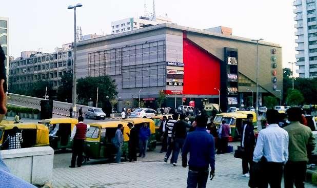
39 A PROPOSED PILOT NEHRU PLACE

40 Line-8, Project 3
41 Project Catchment Area 1. Lack of Connectivity 2. Restricted Mobility, particularly for the vulnerable Asiad 3. Parking Village demand, management Shahpur and Jat enforcement Panchsheel Park Panchsheel Enclave Saket Kailash Colony 4. Safety and sense of safety 5. Drainage Chirag Dilli Sheikh Sarai East of Kailash Greater Kailash-I Greater Kailash-II Garhi Sant Nagar Chitranjan Park Kailash Hills Kalkaji Govindpuri Friends Colony Okhla Phase-III Ishwar Nagar Sukhdev Vihar Okhla Industrial Area Jamia Nagar Jamia Nagar Jamia Nagar Madangir

42 Lack of connectivity - City level grid GK-I Nehru Place District Centre Kalkaji Chirag Dilli GK-II CR Park Okhla Industrial Area Govindpur i Area = 515 Ha. (approx.)


43 Lack of connectivity ORR, a barrier between communities Car Connectivity Distance= 1.7 kms Travel time= 5 mins Cost = Rs Pedestrian Connectivity Distance= 900 m Travel time= 11 mins Cost = Rs No Para-transit connectivity Panchsheel Enclave Panchsheel Enclave Chirag Dilli Metro Station (Phase-III proposal) Chirag Dilli Metro Station (Phase-III proposal) Connectivity will take 2 mins walk
44 Lack of connectivity missing links Connectivity will take 5 mins walk Sant Nagar Sant Nagar Nehru Place Metro Station Nehru Place Metro Station Proposed Pedestrian access Distance= 280 m Travel time= 5 mins Cost = Rs Car accessibility Distance= 1.1 kms Travel time= 3 mins Cost = Rs Pedestrian accessibility Distance= 1.1 kms Travel time= 15 mins Cost = Rs


45 Lack of connectivity missing links Car Connectivity Distance= 1.5 kms Travel time= 5 mins Cost = Rs Nehru Place Metro Station Kalkaji Mandir Guru Harkishan Public School Para-Transit Connectivity Cycle rikshaw (only) Time = 20 mins Cost = 25 Cycle cost = Rs. 00 Pedestrian Connectivity Distance= 650 m Travel time= 08 mins Cost = Rs Nehru Place Metro Station Kalkaji Mandir Guru Harkishan Public School

46 Lack of connectivity - Local barriers


47 Lack of connectivity - Local barriers Park can t be accessed from anywhere else except Nehru Place District Centre. 300 M ZONE 800 M ZONE
48 Restricted mobility- limited options Reaching via CAR Distance= 3.4 Km Time = 7 mins. Cost = Rs. 30.5/-

49 Restricted mobility- limited options Reaching via CAR Distance= 3.4 Km Time = 7 mins. Cost = Rs. 30.5/-

50 Restricted mobility- limited options Reaching on PUBLIC TRANSPORT Time = 24 mins. Cost = Rs. 5/-


51 Restricted mobility- state of infrastructure

52 Restricted mobility- state of infrastructure

53 Restricted mobility- state of infrastructure

54 Restricted mobility- state of infrastructure


55 Safety 8 pm 8 pm 300 M ZONE 800 M ZONE Deserted Roads during evenings/ nights.

56 Safety Road connecting Bus Terminal and Metro Station 7:45 pm

57 Parking KALKAJI BUS STOP

58 Parking PARKING ON ROW MOVING LANE


59 Parking Bus Terminal Multi-Level Parking Surface Parking Public Realm under Surface Parking!


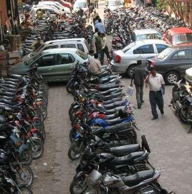
60 Free illegal pvt. parking Disorganised PT parking Parking


61 Nehru Place Station Area Public Realm/ Street Design Issue Dedicated walking space?! No hawking space!

62 Drainage
63 Issues raised by RWAs & Traffic Police - Core Group Meeting 24/07/12 RWAs (residential colonies) 1. Encroachment on footpaths is restricting mobility 2. Storm Water Mgmt essential 3. Need for feeder services inc. Metro Buses, Shared Autos, e-ricks etc. Congestion to be addressed to ensure success Traffic Police (Nehru Place) 1. Aim to make NP essentially car-free 2. Ensure necessary space for emergency evacuation for the large numbers of visitors 3. Provide essential amenities toilets, cloakrooms etc 4. Ease of connectivity necessary for all 4. Provide quick and efficient access from Metro Stations to NP. 5. Provision for NMT parking, and improved MT parking.

64 Nehru Place Station Area Solutions 1. Last mile connectivity through energy efficient modes and improved walkability 2. Pedestrian Crossing facilities at Vulnerable /accident spots THUS Immediate Need for Multi modal integration plans for Metro Station areas. 3. Comfortable and high quality public realm. To achieve the objectives & meet the 6 mandates 4. Creating Safer streets by providing road vitality. 5. Provision for NMT parking, and improved MT parking & better management.
65 PROPOSED PROJECT LIST
66 EAST ZONE Line 7 1. Project-1 i. Yamuna Vihar ii. Maujpur iii. Jaffrabad iv. Welcome 2. Project-2 i. Bholanath ii. Krishna Nagar iii. Jagatpuri iv. Anand Vihar 3. Project-3 i. I.P.Extension ii. Vinod Nagar iii. Vinod Nagar East iv. Trilokpuri Line 8 1. Project-5 i. Okhla Vihar ii. Jasola Vihar iii. Kalindi Kunj iv. Amity Noida v. Botanical Garden AMITY NOIDA
67 WEST ZONE Line 7 1. Project-6 i. Delhi Cantt. ii. Naraina-1 iii. Naraina-2 iv. Mayapuri v. Rajouri Garden 2. Project-7 i. ESI Hospital ii. iii. iv. Line 8 Punjabi Bagh West Shakarpur Netaji Subhash Place 1. Project-1 i. Janakpuri West ii. Janakpuri West C-28 iii. Dabri Mor iv. Dhasrath Puri v. Palam AMITY NOIDA
68 NORTH ZONE Line 7 1. Project-8 i. Shalimar Bagh ii. Azadpur iii. Mukund Pur 2. Project-9 i. Shalimar Place ii. Rohini Sector-18 iii. Baoli AMITY NOIDA
69 SOUTH ZONE Line 7 1. Project-4 i. Hazrat Nizamuddin ii. Ashram iii. Srinivaspuram iv. Lajpat Nagar v. South Extension 2. Project-5 i. INA ii. iii. iv. Sarojini Nagar Bhikaji Cama Place Moti Bagh v. Dhaula Kuan Line 8 1. Project-2 i. IGD Airport ii. Vasant Vihar iii. Munirka iv. R.K.Puram v. IIT 2. Project-3 i. Hauz Khas ii. Panchsheel Park iii. Chirag Dilli iv. G.K.Enclave v. Nehru Place i. Kalkaji ii. Okhla Phase-III AMITY NOIDA 1. Project-4 i. Ishwar Nagar ii. Jamia Nagar iii. Okhla Vihar iv. Jasola Vihar

70 CENTRAL ZONE Line 7 1. Project-10 i. Kashmiri Gate ii. Lal Qila iii. Jama Masjid iv. Delhi Gate 2. Project-11 i. ITO ii. Mandi House iii. Janpath AMITY NOIDA
71 SUMMARY 1. Undertake Nehru Place Area as a Pilot Project for MM Integration & Last mile connectivity with consultant appointed by PWD. 2. Develop a time bound action plan for 2Km zone around all Phase III Metro Station Areas to be undertaken in a Phased manner by all road owning agencies in consultation with all stakeholders 3. All road owning agencies to implement the coordinated plan. Procurement & installation of street furniture / public amenities to ne undertaken by single agency for all roads 4. Parking to be managed by a single agency MCD 5. DMRC to plan & deliver IPT / NMT facilities as per UTTIPEC MRTS Connectivity Checklist in / around all Phase III Metro Station Areas 6. Appointment of consultants by PWD for all projects based on a consistent TOR prepared by UTTIPEC 7. Capacity building within road owning agencies through UTTIPEC workshops 8. Work in sync with DMRC to meet Phase III timelines.
72 THANK YOU!
Implementation and Systemic Change with UTTIPEC Street Design Guidelines
 Implementation and Systemic Change with UTTIPEC Street Design Guidelines Presented by: Ashok Bhattacharjee, Director - Urban Transport Planner, United Traffic & Transportation Infrastructure (Planning
MULTI-MODAL INTEGRATION
 MULTI-MODAL INTEGRATION INTER-CHANGE FACILITIES Needed between the proposed mass transit systems such Metro, BRT and with other feeder services like auto-rickshaws, buses, taxis and non-motorized transport
MPD 2021 Review TOD Policy
 MPD 2021 Review TOD Policy CURRENT CITY PATTERN: Population Density evenly distributed all over city. Large Travel distances & pollution due to segregated land use and vehicular dependency. Rohtak Road
Integrated Multi Modal Public Transit Hub
 Leaders Programme in Urban Transport Planning and Management Integrated Multi Modal Public Transit Hub at Central Business District- Ahmedabad Neela Munshi (Senior Town Planner) Deepa Dave (AM Urban Planner)
Table 5.1. Sample Composition on the Basis of Gender
 Appendix Table 5.1. Sample Composition on the Basis of Gender No. of Respondents Females Males 16 18 Table 5.2. Sample Composition- Age Age Group (yrs.) 30 No. of respondents 3 25 6 Table 5.3.
Page 1 of 7. DELHI DEVELOPMENT AUTHORITY (Master Plan Review Section) 6 th Floor, Vikas Minar, New Delhi:
 6 th Floor, Vikas Minar, New Delhi:") Page 1 of 7 DELHI DEVELOPMENT AUTHORITY (Master Plan Review Section) 6 th Floor, Vikas Minar, New Delhi: 23379731 No.F.1 (10)/2011/ Dir. (Plg.) MPR &TC/Pt. I /D-65 Dt: 10/06/2014 Subject: Minutes of the
Page 1 of 7 DELHI DEVELOPMENT AUTHORITY (Master Plan Review Section) 6 th Floor, Vikas Minar, New Delhi: 23379731 No.F.1 (10)/2011/ Dir. (Plg.) MPR &TC/Pt. I /D-65 Dt: 10/06/2014 Subject: Minutes of the
CITYSCAPES. Public transit may not be a doorstep to door step service. Shorter trips could be made by non motorized transport ECO MOBILITY
 Delhi occupied by ROAD AND VEHICLES 2011 Remaining Area CITYSCAPES. 21% 9% 18% Roads Vehicles - 66 lakh till 30 April 2011 - origin parking Vehicles - parking at different destinations MAKING OUR CITIES
Final Master Plan and Development Control Regulations
 1. INTRODUCTION CHECK LIST a. Introduction b. Table of contents c. Definitions. d. scope of works. 2. FINAL OVERALL MASTER PLAN a. SITE ANALYSIS and OVERVIEW: i. Existing and Proposed Site Plan Levels.
Transportation. Strategies for Action
 Transportation A major priority for the Overlake Neighborhood is to develop a multimodal transportation system. To achieve this system, a balance has to be found among travel, circulation and access needs;
Delhi Urban Art Commission PUBLIC NOTICE
 Delhi Urban Art Commission PUBLIC NOTICE The Delhi Urban Art Commission prepared Guidelines on Public Art in Delhi which were deliberated in a Roundtable on the subject Chaired by the Hon ble Minister
Executive Summary. NY 7 / NY 2 Corridor
 Executive Summary NY 7 / NY 2 Corridor Transportation and Land Use Study December 2005 Prepared for: Town of Colonie Capital District Transportation Committee Prepared by: Introduction: Land use decisions
HS2 Interchange Station Design
 Working on behalf of HS2 Interchange Station Design October 2018 www.hs2.org.uk 1 Interchange Station, Solihull Introduction In February 2018, HS2 Ltd appointed Arup to take forward the design of Interchange
SUSTAINABLE TRANSPORT & INTEGRATED LAND USE PLANNING
 SUSTAINABLE TRANSPORT & INTEGRATED LAND USE PLANNING UNESCAP Capacity Building Workshop, Colombo Integrated Land use and Urban Transport Planning : Principles and Practices 31st October 2017 ACTIVE TRANSPORTATION
Integrated Urban Development. April Reflections from the NZPI Study Tour of Portland, Seattle and Vancouver
 Integrated Urban Development April 2009 Reflections from the NZPI Study Tour of Portland, Seattle and Vancouver Integrated Urban Development Urban Growth Management Transportation Transit Orientated Mixed
BRIDGES, FLYOVERS AND ELEVATED MRTS STRUCTURES
 2016 Edition BRIDGES, FLYOVERS AND ELEVATED MRTS STRUCTURES Trends, Outlook and Projections Research Report Data-set (Excel) Four Quarterly Updates India Infrastructure Research www.indiainfrastructure.com
City of Hermosa Beach Administrative Policy #
 City of Hermosa Beach Administrative Policy # SUBJECT: Living Streets Policy Date: Approved by: City Council Authority: Public Works Department & Community Development Department Mayor, PURPOSE The City
Town of Oakville Streetscape Strategy
 Town of Oakville Streetscape Strategy Endorsed by PDC on February 10, 2014 (PD-011-14) Town of Oakville Streetscape Strategy [endorsed by PDC February 10, 2014] 0 Town of Oakville Streetscape Strategy
TOD GUIDANCE DOCUMENT & CITY SPECIFIC PLANS
 National Dissemination Workshop Guidance Documents For Transit Oriented Development (TOD), Non-Motorised Transport (NMT) And Public Bicycle Sharing (PBS) TOD GUIDANCE DOCUMENT & CITY SPECIFIC PLANS IBI
TRANSPORTATION ELEMENT GOALS, OBJECTIVES, AND POLICIES
 TRANSPORTATION ELEMENT GOALS, OBJECTIVES, AND POLICIES GOAL 2 The City shall provide a safe, convenient, effective, and energy efficient multimodal transportation system which is coordinated with the Future
LEADERS IN URBAN TRANSPORT PLANNING. Ahmedabad Urban Development Authority
 LEADERS IN URBAN TRANSPORT PLANNING Ahmedabad Urban Development Authority Regional Context Gandhinagar Twin City 4 Growth centers and Satellite Towns Sanand SIR, Changodar SIR Dholera SIR, SEZs 2 What
North Somerset Council Local Development Framework
 North Somerset Council Local Development Framework Sites and Policies Development Plan Document Evidence Paper Re-opening Portishead Railway Line and Options for the Location of Portishead Railway Station
COMMERCIAL USE & AREAS
 07-02-2009 COMMERCIAL USE & AREAS (PAST, PRESENT & FUTURE) UPS CAMPUS, BLOCK A, PREET VIHAR, DELHI 92 1 See at: www.rgmp.org 1. COMMERCIAL USE & AREAS (PAST, PRESENT & FUTURE) This land use is creating
PLAN ELEMENTS WORKSHOP. April 5, 2016
 PLAN ELEMENTS WORKSHOP April 5, 2016 needs more housing. But there is no one-size fits-all solution. Every neighborhood has its own character. In some places, density is not only appropriate it is badly
Local Growth Planning in North Central Green Line Communities
 2018 April 30 Page 1 of 6 EXECUTIVE SUMMARY This report outlines a high-level scope for local growth planning for north central Green Line communities. The catalyst for this review is the significant investments
Village Enhancement Scheme Barton under Needwood
 Barton Village Enhancement Scheme Village Enhancement Scheme Barton under Needwood Executive summary May 2014 Village enhancement scheme: executive summary 1 Barton Village Enhancement Scheme Executive
TRANSPORT & INFRASTRUCTURE
 Pegasus Group PEGASUS GROUP TRANSPORT & INFRASTRUCTURE OUR SERVICES PLANNING DESIGN ENVIRONMENT ECONOMICS Our specialist team of transport planners, traffic engineers and infrastructure designers provide
Johnson Street Bridge Public Realm Update
 Johnson Street Bridge Public Realm Update August 20, 2015 Background Johnson Street Bridge Replacement Project impacts a diverse range of stakeholders In addition to a new bridge, the project also includes
Aldershot GO Draft Mobility Hub Concepts. East Plains United Church September 13, :30 8:30 pm
 Aldershot GO Draft Mobility Hub Concepts East Plains United Church September 13, 2017 6:30 8:30 pm Today s Agenda 6:30pm: 6:35pm: 7:10pm: 8:10pm: 8:25pm: Opening Remarks Rosa Bustamante, Manager Mobility
5 th Regional EST Forum in Asia A new decade in sustainable transport
 5 th Regional EST Forum in Asia A new decade in sustainable transport Keynote address on India s Experience in Implementing Sustainable Urban Transport By Sri Saugata Roy Hon ble Minister of State for
Toronto Complete Streets Guidelines Stakeholder Advisory Group #
 Toronto Complete Streets Guidelines Stakeholder Advisory Group #1 2015-03-24 What are Complete Streets? 2 Streets designed with all users in mind: pedestrians/those with disabilities cyclists street car
CITY OF CHARLOTTESVILLE, VIRGINIA CITY COUNCIL AGENDA
 CITY OF CHARLOTTESVILLE, VIRGINIA CITY COUNCIL AGENDA Agenda Date: December 16, 2013 Action Required: Adoption of Resolution Presenter: Staff Contacts: Title: James E. Tolbert, AICP, Director of NDS James
Are we creating and exploiting synergies on our transit investments?
 10 Years of TOD in the Denver Front Range Region: Are we creating and exploiting synergies on our transit investments? Tim Van Meter Van Meter Williams Pollack Architecture & Urban Design San Francisco
Scope of Services. River Oaks Boulevard (SH 183) Corridor Master Plan
 Corridor Master Plan") Scope of Services River Oaks Boulevard (SH 183) Corridor Master Plan PROJECT AREA The project area consists of the River Oaks Boulevard (SH 183) corridor bounded by SH 199 at the northern end and the Trinity
Scope of Services River Oaks Boulevard (SH 183) Corridor Master Plan PROJECT AREA The project area consists of the River Oaks Boulevard (SH 183) corridor bounded by SH 199 at the northern end and the Trinity
«Corridor» designs in town planning : Sustainable planning for large cities in developed countries
 CODATU XIII «Corridor» designs in town planning : Sustainable planning for large cities in developed countries Challenges of implementation in booming cities in emerging and developing countries Lyon Town
California Environmental Quality Act (CEQA) Environmental Review Process
 Environmental Review Process") California Environmental Quality Act (CEQA) Environmental Review Process Los Angeles Union Station Forecourt and Esplanade Improvements constitute a Project Los Angeles County Metropolitan Transportation
California Environmental Quality Act (CEQA) Environmental Review Process Los Angeles Union Station Forecourt and Esplanade Improvements constitute a Project Los Angeles County Metropolitan Transportation
1.0 Purpose of a Secondary Plan for the Masonville Transit Village
 Report to Planning and Environment Committee To: Chair and Members Planning & Environment Committee From: John M. Fleming Managing Director, Planning and City Planner Subject: Masonville Transit Village
John M. Fleming Managing Director, Planning and City Planner. Old East Village Dundas Street Corridor Secondary Plan Draft Terms of Reference
 Report to Planning and Environment Committee To: From: Subject: Chair and Members Planning & Environment Committee John M. Fleming Managing Director, Planning and City Planner Old East Village Dundas Street
Don Mills Crossing Study and Celestica Lands Development Application Community Meeting, Open House, and Breakout Discussions
 Consultation Summary Don Mills Crossing Study and Celestica Lands Development Application Community Meeting, Open House, and Breakout Discussions This report is not intended to provide a verbatim transcript
TORONTO COMPLETE STREETS GUIDELINES
 TORONTO COMPLETE STREETS GUIDELINES Presentation by Fiona Chapman, Manager, Pedestrian Projects Public Realm Section, Transportation Services, City of Toronto June 2017 PURPOSE OF THE PROJECT To develop
Cambie Corridor Planning Program Phase Two Draft Plan. Standing Committee on City Services and Budgets May 5, 2011
 Cambie Corridor Planning Program Phase Two Draft Plan Standing Committee on City Services and Budgets May 5, 2011 Cambie Corridor Program Terms of Reference approved July 2009 Land Use Transportation Energy
GO Station Mobility Hubs: Draft Precinct Plans. Committee of the Whole July 12, 2018
 GO Station Mobility Hubs: Draft Precinct Plans Committee of the Whole July 12, 2018 Purpose of this Workshop Present Draft Precinct Plans for the 3 GO Station Mobility Hubs Continue the conversations that
Connecting Key Activity Centers with High Quality Bus Service
 Connecting Key Activity Centers with High Quality Bus Service Lessons Learned from the DC Circulator Transit Development Plan April 15, 2011 1 DC Circulator Transit Development Plan Ten-year plan for development
Complete Neighbourhood Guidelines Review Tool
 Complete Neighbourhood Guidelines Review Tool Prepared By: City of Regina Planning Department October 2014 Page 1 of 14 Community Development Review Checklist for Secondary Plans and Concept Plans The
Welcome! MILLENNIUM LINE BROADWAY EXTENSION. Over the next 30 years, Metro Vancouver will welcome 1 million new residents and 600,000 new jobs.
 WELCOME Welcome! MILLENNIUM LINE BROADWAY EXTENSION Over the next 30 years, Metro Vancouver will welcome 1 million new residents and 600,000 new jobs. The Broadway Corridor is home to the second largest
ALLOY ENTERPRISES BRINGING LIFE TO YOUR HOMES
 ALLOY ENTERPRISES BRINGING LIFE TO YOUR HOMES COMPANY S PROFILE ALLOY ENTERPRISES is a solution provider and a manufacturing company for windows openings, shutters, rapid action doors and projection screens.
Welcome. Walk Around. Talk to Us. Write Down Your Comments
 Welcome This is an information meeting introducing the applications for proposed redevelopment of the Yorkdale Shopping Centre site at 3401 Dufferin Street and 1 Yorkdale Road over the next 20+ years,
TRANSIT ORIENTED DEVELOPMENT
 TRANSIT ORIENTED DEVELOPMENT Dhaka September 13, 2018 Prof. H. M. Shivanand Swamy Centre of Excellence in Urban Transport Why TOD? Economic Increased Density in prime, Convenient Locations Environmental
Task Force on Kai Tak Harbourfront Development
 Task Force on Kai Tak Harbourfront Development For discussion on 29 March 2018 TFKT/04/2018 Study of Kai Tak Promenade Design Control and Guidelines Conceptual design scheme for Promenade at Runway Precinct
PD&E STUDY SR 9/I-95 FROM SOUTH OF SR 870/COMMERCIAL BOULEVARD TO NORTH OF CYPRESS CREEK ROAD FM # ETDM 14222
 PD&E STUDY SR 870/COMMERCIAL BOULEVARD TO NORTH OF CYPRESS CREEK ROAD FM # 435808-1-22-02 ETDM 14222 WELCOME TO THE KICK-OFF MEETING May 24, 2016 1 1 2 3 4 5 6 PLANNING PROJECT DEVELOPMENT AND ENVIRONMENT
CHAPTER 3 VISION, GOALS, & PLANNING PRINCIPLES. City of Greensburg Comprehensive Plan. Introduction. Vision Statement. Growth Management Goals.
 CHAPTER 3 VISION, GOALS, & PLANNING PRINCIPLES Introduction The Greensburg Comprehensive Plan is intended as a working community document. A combination of long and short-term goals, this document is intended
CITY LEVEL PROJECTS. Delhi Greenways. Four City Level Landscape Projects
 CITY LEVEL PROJECTS Delhi Greenways Four City Level Landscape Projects Acknowledgements It is said that for an artist to join establishment is a kiss of death. I was fully aware of this aphorism when the
SR 836 Southwest Extension
 SR 836 Southwest Extension Miami-Dade County, Florida August 8, 2018 MDX WORK PROGRAM NO.: 83618 Project Need Population growth and traffic in southwest Miami-Dade has significantly increased without the
I615. Westgate Precinct
 I615. Westgate Precinct I615.1. Precinct Description The Westgate Precinct is located approximately 18km west of the Auckland city centre. There are seven Sub-precincts in the Westgate Precinct: Sub-precinct
This Review Is Divided Into Two Phases:
 Semiahmoo Town Centre Review The purpose of this review: To review the Semiahmoo Town Centre Concept Plan, originally approved in 1993, to ensure that this centre will continue to serve the needs of South
Making the case for Sustainable Transport Project Potential
 Making the case for Sustainable Transport Project Potential The Structural Investment Fund (SIF) Strategy for Greater Lincolnshire identifies the barriers to growth identified by having poor transport
greenprint midtown SUSTAINABILITY ACTION PLAN 2012
 greenprint midtown SUSTAINABILITY ACTION PLAN 2012 MIDTOWN ALLIANCE SOUTHFACE ENERGY INSTITUTE RENAISSANCE PLANNING GROUP SUSTAINABLE ATLANTA PERKINS+WILL 2 GREENPRINT MIDTOWN 1. Introduction Sustainability
1. Creating a liveable, vibrant, safe and inclusive city centre for the benefit of people of all ages to live, work, learn and enjoy.
 City Centre Framework - Summary Bristol City Council has produced a draft City Centre Framework document. The Framework is a planning and transport document that outlines what the city centre could be
Streets for People, Place-Making and Prosperity. #TOcompletestreets
 COMPLETE STREETS FOR TORONTO Streets for People, Place-Making and Prosperity COMPLETE STREETS: A NEW APPROACH A Complete Streets design approach considers the needs of all users people who walk, bicycle,
Public Open House. Overview of the Downtown Plan Official Plan Amendment April 23, 2018
 Public Open House Overview of the Downtown Plan Official Plan Amendment April 23, 2018 1 A 25-Year Plan for Downtown To ensure growth contributes positively to Toronto s Downtown as a great place to live,
City of Fort Lauderdale UPTOWN URBAN VILLAGE. Public Workshop December 7, 2016
 Public Workshop December 7, 2016 Workshop Agenda Introductions Project Presentation o o o History Project Scope/Timeline Character of Study Area o o o o Land Use Public Realm/Pedestrian Mobility Multimodal
Plan Framework Report. Attachment A
 Plan Framework Report Attachment A Uptown-Douglas Corridor Plan - Plan Framework Report Contents Introduction... 1 Planning Process... 3 Project Objectives... 4 Vision... 5 Community Values... 6 Structural
Energy Efficient Strategies for Urban Transportation Planning
 EinT2018 3 rd International Conference ENERGY in TRANSPORTATION 2018 Energy Efficient Strategies for Urban Transportation Planning Prof. Dr. Doaa M. El-Sherif, PhD, Arch. Email: doaa_elsherif@yahoo.com
St. Clair Avenue West Area Transportation Master Plan
 1 (Between Keele Street and Old Weston Road) Public Information Centre 1 December 2, 2015 2 Welcome Welcome to the first Public Information Centre for the St. Clair Avenue West Area. The panels will present
The Project. In 2013, construction was completed between 100 Street and 102 Street.
 The Project Jasper Avenue New Vision (JANV) is a major catalyst project identified in the Capital City Downtown Plan (2010) between 92 Street and 109 Street, including the streets half a block north and
Innovative Transportation Planning, Design & Technology in Fairfax County, VA
 Innovative Transportation Planning, Design & Technology in Fairfax County, VA American Society of Highway Engineers (ASHE) November 16, 2016 Presented By W. Todd Minnix, PE Chief, Transportation Design
LAND USE AMENDMENT CORNERSTONE (WARD 3) 60 STREET NE AND COUNTRY HILLS BOULEVARD NE MAP 26NE BYLAW 22D2017
 60 STREET NE AND COUNTRY HILLS BOULEVARD NE MAP 26NE BYLAW 22D2017") Page 1 of 14 EXECUTIVE SUMMARY This Land Use Amendment application covers an area of 43.76 hectares ± (108.14 acres ±) located in northeast Calgary, bound by Country Hills Boulevard NE to the south and
Page 1 of 14 EXECUTIVE SUMMARY This Land Use Amendment application covers an area of 43.76 hectares ± (108.14 acres ±) located in northeast Calgary, bound by Country Hills Boulevard NE to the south and
Silverdale Regional Center
 Silverdale Regional Center Vision for Silverdale Regional Center The Silverdale Regional Center Plan (Plan) will guide the evolution of the Silverdale Regional Center from a collection of strip malls and
University of the District of Columbia Van Ness Campus Master Plan Community Open House 3. December 8, 2010
 University of the District of Columbia Van Ness Campus Master Plan Open House 3 December 8, 2010 Introductions Sequence of Work: Campus Master Plan BEGIN: INTRODUCE AND START WORK Project Initiation Team
CITY OF VAUGHAN EXTRACT FROM COUNCIL MEETING MINUTES OF NOVEMBER 15, 2016
 Item 11, Report No. 38, of the Committee of the Whole, which was adopted without amendment by the Council of the City of Vaughan on November 15, 2016. Regional Councillor Di Biase declared an interest
October 25 Downtown Partnership and Action Plan Workshop Record of Group Table Results
 October 25 Downtown Partnership and Action Plan Workshop Record of Group Table Results During the October 25 workshop, participants were asked to rank their top priorities for the Downtown Action Plan.
The Vision. Photo provided by The Minervini Group. 46 Vision, Objectives & Strategies
 Vision, Objectives & Strategies The is the public framework and guide for future development of the Grand Traverse Commons. The establishes public polices for infrastructure, the preservation of natural
PRESENTING ONE OF NCR'S BEST GOLF TOWNSHIP JOINT VENTURE PARTNER
 PRESENTING ONE OF NCR'S BEST GOLF TOWNSHIP JOINT VENTURE PARTNER LOCATION MAP Akshardham Temple Mayur Vihar Towards Delhi Towards Delhi DND Expressway Film City Sector 18 Metro Station Jasola Vihar Okhla
GREATER CAMBRIDGE CITY DEAL. Urban Design Guidance for Transport Infrastructure Projects
 GREATER CAMBRIDGE CITY DEAL Urban Design Guidance for Transport Infrastructure Projects KEY OBJECTIVES OF CITY DEAL The City Deal aims to help Greater Cambridge maintain and grow its status as a prosperous
Metro 2010 Pedestrian Symposium Walking into the Future City
 Metro 2010 Pedestrian Symposium Walking into the Future City John Kaliski, AIA, May 12, 2010 How can our transportation and land use policies create complete streets for all users? How do we optimize the
DELHI URBAN MASS TRANSIT AUTHORITY
 DUMTA DELHI URBAN MASS TRANSIT AUTHORITY GOVERNANCE STRUCTURE AND FUNCTIONS R.G. GUPTA Policy/City Planner TH TOI- DATED 13 APRIL, 2010 STATES AS UNDER We do not have any control over planning, land and
Published in March 2005 by the. Ministry for the Environment. PO Box , Wellington, New Zealand ISBN: X.
 Action Pack Published in March 2005 by the Ministry for the Environment Manatū Mō Te Taiao PO Box 10-362, Wellington, New Zealand ISBN: 0-478-18994-X ME number: 580 This document is available on the Ministry
CHAPTER 7: Transportation, Mobility and Circulation
 AGLE AREA COMMUNITY Plan CHAPTER 7 CHAPTER 7: Transportation, Mobility and Circulation Transportation, Mobility and Circulation The purpose of the Transportation, Mobility and Circulation Chapter is to
EXPANDING THE NETWORK ALEXANDRIA, VIRGINIA
 EXPANDING THE NETWORK ALEXANDRIA, VIRGINIA David Whyte david.whyte@kimley-horn.com Overview Project Context Corridors Land Use Coordination Concepts Outreach and Coordination Results Core of the region
Pioneering the Sustainable Future of Pakistan. A New Destination of Islamabad
 Pioneering the Sustainable Future of Pakistan A New Destination of Islamabad A New Destination of Islamabad C A P I TAL S M A R T CIT Y ISL A M A B A D, PAKISTA N CAPITAL SMART CITY ISLAMABAD C A P I TAL
Welcome! Please sign-in and participate in the activities in the registration area before finding your seat. Thank you!
 Welcome! Please sign-in and participate in the activities in the registration area before finding your seat. Thank you! Planning Kickoff July 31, 2018 University of Baltimore Public Planning Kick-off Agenda
St. Anthony Park Community Council 10-year Planning Community Forum
 St. Anthony Park Community Council 10-year Planning Community Forum Introductions: Who are we? North SAP (North of Energy Park) South SAP (South of Energy Park) Introductions: Who are we? Live Play Work
What Does It Take To Create A Town Center?
 What Does It Take To Create A Town Center? Context, Design, and Process The Prince Frederick Master Plan Update 1 Background and Overview A Brief History of Town Centers in Calvert County 2 Background
2035 General Plan Update and Belmont Village Specific Plan. Joint Study Session with the City Council and Planning Commission April 12, 2016
 2035 General Plan Update and Belmont Village Specific Plan Joint Study with the City Council and Planning Commission April 12, 2016 Agenda 1. Welcome and Introductions 2. General Plan Update Status of
FLORIN ROAD CORRIDOR Site Plan and Design Review Guidelines Checklist
 FLORIN ROAD CORRIDOR Site Plan and Design Review Guidelines Checklist Applicant s Name: Project Address: Phone: Email: Applicant shall fill out the design guidelines checklist for all guidelines applicable
Stakeholders Advisory Working Groups (SAWGs) Smart Growth and TOD Land Use (#11) SAWG Meeting
 Smart Growth and TOD Land Use (#11) SAWG Meeting") Presentation - Part II Tappan Zee Bridge/I-287 Corridor Project July 21, 2010 Slide 1. David Kooris (Regional Plan Association) welcomed members of the Land Use Stakeholders Advisory Working Groups (SAWGs)
Presentation - Part II Tappan Zee Bridge/I-287 Corridor Project July 21, 2010 Slide 1. David Kooris (Regional Plan Association) welcomed members of the Land Use Stakeholders Advisory Working Groups (SAWGs)
Taming Tysons Corner Transforming the Quintessential Edge City
 Taming Tysons Corner Transforming the Quintessential Edge City Transit is the greatest catalyst for change at Tysons, but how do we take advantage of this billion-dollar investment? If transit is built
Vietnam Scaling up Urban Upgrading Project (SUUP)
") 1. Introduction Vietnam Scaling up Urban Upgrading Project (SUUP) Terms of Reference (TOR) Technical Advisory Services on Universally Accessible Infrastructure Design September 2018 The project is part
1. Introduction Vietnam Scaling up Urban Upgrading Project (SUUP) Terms of Reference (TOR) Technical Advisory Services on Universally Accessible Infrastructure Design September 2018 The project is part
ELMVALE ACRES SHOPPING CENTRE MASTER PLAN
 ELMVALE ACRES SHOPPING CENTRE MASTER PLAN Contents 1.0 INTRODUCTION... 2 2.0 LOCATION... 2 3.0 EXISTING CONTEXT... 2 4.0 VISION & GUIDING PRINCIPLES... 2 5.0 LAND USE AND BUILT FORM... 4 5.1 St. Laurent
MOBILITY HUB GUIDELINES 2012 TAC Sustainable Urban Transportation Award Submission BACKGROUND MOBILITY HUB GUIDELINES
 MOBILITY HUB GUIDELINES 2012 TAC Sustainable Urban Transportation Award Submission BACKGROUND Rapid population growth, increasing congestion, and years of under investment in transit in the Greater Toronto
CHAPTER 5: GUIDING PRINCIPLES
 CHAPTER 5: GUIDING PRINCIPLES The following 10 principles were developed based on public consultation, planning policy and the background analysis conducted during Phase 1. The Guiding Principles significantly
BETTER PUBLIC TRANSPORT PROJECT WATERBEACH TO SCIENCE PARK AND EAST CAMBRIDGE CORRIDORS
 Report To: Greater Cambridge Partnership Joint Assembly 20 th September 2018 Lead Officer: Peter Blake GCP Director of Transport BETTER PUBLIC TRANSPORT PROJECT WATERBEACH TO SCIENCE PARK AND EAST CAMBRIDGE
INTERIM ADVICE NOTE 143/11
 INTERIM ADVICE NOTE 43/ Supplementary Advice and requirements for the Accessibility during planning, design, construction and handover of Improvement Schemes Summary This document provides additional advice
EU Guidelines on Sustainable Urban Mobility Plans
 EU Guidelines on Sustainable Urban Mobility Plans UNDP Workshop on SUMP, Belgrade, 21 September 2012 Frank Wefering, Rupprecht Consult SUMP a concept promoted by the EU Sustainable Urban Mobility Plans
Bethesda Downtown Plan
 Bethesda Downtown Plan Planning Board Update Connecticut Avenue Location Economic Sustainability Social Environmental Scope Coming Soon! Team Listening, Twitter Outreach We Are Here Engagement Challenge
Purchase: (Fire Fighting) May 26, Sub: Quotation for AMC of Fire Fighting Systems
 May 26, Sub: Quotation for AMC of Fire Fighting Systems") Purchase: 2015-16(Fire Fighting) May 26, 2015 Sub: Quotation for AMC of Fire Fighting Systems Dear Sir, The Institute of Company Secretaries of India is a statutory body set up by an Act of Parliament.
Purchase: 2015-16(Fire Fighting) May 26, 2015 Sub: Quotation for AMC of Fire Fighting Systems Dear Sir, The Institute of Company Secretaries of India is a statutory body set up by an Act of Parliament.
History: a Grand Urban Boulevard
 History: a Grand Urban Boulevard 1890 1910: At its peak, Euclid Avenue, "Millionaire's Row," was considered the second most beautiful urban street in the country next to Fifth Avenue in Manhattan. 1910-2030:
Toronto Complete Streets Guidelines
 c. DTAH 58 60 3.1 70 3.2 Performance Measurement 71 3.3 Exceptions Chapter 3 describes the five general steps in the street design process. Not all projects follow these steps, as the number of steps and
Community Design Guidelines. Port Wallace DRAFT
 Community Design Guidelines Port Wallace DRAFT Energy 1 2 3 Nature Movement Connections Built Form DRAFT Layout Energy 1 Nature Community Design Guidelines GREAT COMMUNITIES PROTECT, CELEBRATE, AND CONSERVE
3. Neighbourhood Plans and Strategic Environmental Assessment
 1. Introduction This report sets out a draft Screening Determination for the Preston Parish Council s Neighbourhood Plan and has been prepared by rth Hertfordshire District Council. The purpose of the
Project Profile BAR HARBOR
 1 BAR HARBOR The Bar Harbor Master Plan merges community vision with design guidelines to preserve the unique character of Bar Harbor Village. PROJECT SUMMARY Overview: The economic vitality of Bar Harbor