Village of Niles, Illinois TOUHY TRIANGLE MASTER PLAN EXECUTIVE SUMMARY. Gewalt Hamilton Associates
|
|
|
- Holly Brown
- 5 years ago
- Views:
Transcription


1 Village of Niles, Illinois TOUHY TRIANGLE MASTER PLAN EXECUTIVE SUMMARY Gewalt Hamilton Associates NOVEMBER 2016
2
3 Plan Purpose One of the Top Community Issues to emerge from the Niles 2030 Comprehensive Plan was the Village's lack of a 'true downtown area', which was believed to "negatively impact the Village's sense of community, image and identity". In response the Village of Niles has undertaken a proactive effort to develop and implement a bold vision for a new town center within the Touhy Triangle. In support of this vision, the Touhy Triangle Master Plan was developed with an aim to achieve the following goals: Enhance Economic Vitality the new plan calls for a vibrant, mixed-use, entertainment district with strong commercial uses and modern employment centers. Foster a Greater Sense of Community in the future the Touhy Triangle will be a distinct, vibrant place that residents will proudly identify as the 'heart' of their community. Provide Opportunities for Recreation and Entertainment new public open spaces programmed with a variety of amenities and activities will anchor a range of active commercial and entertainment-oriented uses. Promote Arts and Culture within the Village as a key destination within the region, the new town center will provide a setting for concerts in the park, fairs and festivals, and public art opportunities all set within a rich urban environment. The Village will work in close partnership with area land and business owners, residents, and the development community to achieve these goals. iii
4 X AVE EXISTING CONDITIONS OVERVIEW The Touhy Triangle Master Plan, prepared by The Lakota Group and Gewalt Hamilton Associates, examines the prevailing land use and building patterns, transportation and infrastructure conditions, and development potential of the Touhy Triangle area in Niles. Out of this analysis, a site development and planning framework was established, including a master plan vision for the Study Area. While the Plan is intended to serve as an essential resource in guiding the area s future redevelopment, a more detailed examination of real estate market trends will ultimately be required to determine final plan direction. Currently, the site is zoned for entertainment and mixed-use development (ENT-MU), however, until recently, it was zoned primarily for larger-scale industrial (M) or service business uses (B2), with a limited amount of retail business zoning (B1) in specific locations. Previous Niles Zoning Map RE P1 #3 R3 JARVIS ST CALDWELL AVE R1 R1 B1 HARTS RD NATCHEZ AVE B2 VE CRONAME RD GROSS POINT RD B2 AVE MELVINA AVE HOWARD ST B2 M SHERWIN AVE MEADE AVE MCVICKER AVE OLD LEHIGH AVE B1 B2 NE P JARVIS ST MENARD AVE M PUD Existing traffic levels near the Study Area are relatively high especially on Touhy Avenue suggesting the potential for high visibility and exposure for any new development within the area. Study Area Size: ~110 ACRES Existing Traffic Signals & ADT Map X,XXX Current Zoning: ENT-MU ENTERTAINMENT / MIXED-USE 18,150 Previous Zoning: M - LIMITED MANUFACTURING B2 SERVICE BUSINESS B1 RETAIL BUSINESS 4,750 4,850 Max. F.A.R.: 1.5 (M), 1.8 (B1), 2.0 (B2) Max. Height: 36 FEET 25,800 26,100 39,000 Typical Building: 2 3 STORIES 140, ,000 SF iv 19,100

5 Study Area Context Map LEGEND REVOLUTION DANCE WEAR VILLAGE OF SKOKIE STUDY AREA MUNICIPAL BOUNDARY STUDY AREA CORE (110 ACRES) EXISTING BUILDINGS PARKING AREAS / DRIVES CALDWELL AVE CRONAME RD VILLAGE OF FORT DEARBORN COMPANY NIMLOCK EXHIBITS GRAINGER BANKIER CO LIFEWAY FOODS EPC PRINTING JARVIS AVE COSTCO AMER. SCIENCE & SURPLUS GROSS POINT ROAD AETNA SCREW BEE SALES CO. PREF. MEDIA IWC LEANING TOWER YMCA GRAINGER ALDI MELVINA AVE TARGET MEADE AVE GARVEY GROUP JOHNSON & QUIN LEHIGH AVE VILLAGE OF SHURE BUNKER HILL CITY OF CHICAGO v
6 DEVELOPMENT POTENTIAL Infrastructure Major utility lines within the study area have also been highlighted on the Site Analysis Map on the facing page (dashed purple lines), indicating potential obstacles to be considered when exploring future development opportunities. While most of the utility lines serving the area are located within the right-of-ways of existing streets, and are therefore unlikely to require relocation, it should be noted that significant modifications to the roadway network may impact utilities. Several key lines are identified on the preceding page and described below water main to the East of 6450 W. Touhy, runs north to south, about 1, water main to the west of W. Touhy, runs north to south, about 1, Melvina Avenue, 10 water main, sanitary sewer and storm sewer (10-36 ) and 12 water main running behind 6150 Touhy & 7311 Melvina. The section behind 6150 Touhy is likely to remain storm sewer that runs from Gross Point (along the extension of Jarvis Ave) towards the west to Gross Point. 6. There is sanitary, storm and water main running mostly north & south to the East of 7300 Leigh. Stormwater Given the reasonably high value of land within the study area, it is assumed that most stormwater detention will occur underground, though a portion of storage could be supported through surface retention in the form of parking lots, open spaces, and rain gardens or bio-swales. For the purposes of this planning effort, Gewalt Hamilton Associates has calculated a conceptual stormwater detention requirement ratio of 0.35 acre feet for every 1 acre redeveloped. Anticipated Future Stormwater Allocation: Anticipated Future Stormwater Allocation: 85% UNDERGROUND STORAGE 15% SURFACE RETENTION vi Development Opportunities and Constraints A number of existing opportunities and constraints will have a direct impact on the physical design and character of the Study Area s future redevelopment. Potential for Change The Site Analysis Map shown on the next page outlines the extent to which each building in the study area is susceptible to change. The designations shown are based a variety of criteria, taking into account factors like building age and condition, functional significance, ownership, locational relevance, and environmental issues. Connectivity Several opportunities exist to enable greater connectivity between the Touhy Triangle and surrounding neighborhoods, but remain unrealized due to existing conditions. One major opportunity is to establish an improved connection with the North Branch Trail, which intersects with Touhy Avenue immediately west of the study area. Another opportunity for enhanced connectivity is the site s proximity to the terminus of several CTA bus lines on Gross Point Road. There are also a number of potential street and road network enhancements that could help to improve connectivity within and around the Touhy Triangle. One example includes enabling better connectivity between Gross Point Road, Lehigh Avenue, and Howard Street in the far northeast corner of the Study Area. Branding Two key signage opportunities are identified on the Site Analysis Map at the intersections of Touhy Avenue, Gross Point Road, and Lehigh Avenue, respectively. Major gateway/landmark elements are recommended in these areas due to the high visibility of these locations (identified by yellow asterisks).
7 Site Development Potential Analysis Map LEGEND STUDY AREA MUNICIPAL BOUNDARY KEY SIGNAGE OPPORTUNITY PEDESTRIAN CONNECTION POTENTIAL TO CHANGE LIMITED POTENTIAL TO CHANGE NOT LIKELY TO CHANGE KEY EXISTING UTILITIES OR INFRASTRUCTURE CALDWELL AVE CRONAME RD VILLAGE OF REVOLUTION DANCE WEAR Potential School District Transportation Center FORT DEARBORN COMPANY NIMLOCK EXHIBITS VILLAGE OF SKOKIE GRAINGER BANKIER CO LIFEWAY FOODS EPC PRINTING 5 JARVIS AVE COSTCO AMER. SCIENCE & SURPLUS Potential North Branch Trail Connections 1 GROSS POINT ROAD 2 AETNA SCREW BEE SALES CO. PREF. MEDIA IWC LEANING TOWER YMCA GRAINGER ALDI 3 4 MELVINA AVE TARGET MEADE AVE GARVEY GROUP JOHNSON & QUIN 6 LEHIGH AVE VILLAGE OF SHURE North Branch Trail BUNKER HILL End of CTA Bus Lines Missing Sidewalk CITY OF CHICAGO vii
8 Site Organization Specific areas within the Touhy Triangle have been identified as potential development pods or clusters, establishing a broad-level of organization. Area 1 Total Area Size: ~33 ACRES Priority Uses: COMMERCIAL & ENTERTAINMENT Area 2 Total Area Size: ~26.5 ACRES Priority Uses: LIGHT INDUSTRIAL, OFFICE, AND/OR COMMERCIAL Area 3 Total Area Size: ~20 ACRES Priority Uses: COMMERCIAL, LIGHT INDUSTRIAL, OR MANUFACTURING Development Framework The Potential Development Framework shown on the facing page establishes an over-arching strategy for redevelopment of the Touhy Triangle, balancing physical design requirements while also maintaining enough flexibility to accommodate a wide range of land use goals. Framework Notes Opportunity Site A 95,970 square feet (2.20 acres) Opportunity Site B 68,750 square feet (1.58 Acres) Opportunity Site C 275,000 square feet (6.31 Acres) Site D 11,000 square feet (0.25 acres). New linear open space. Site E 72,000 square feet (1.65 acres). New central open space Site F 40,000 square feet (0.92 acres) Refurbished, existing landmark open space. Leaning Tower landmark to be preserved. Opportunity Site G 72,500 square feet (1.66 acres) Opportunity Site H 395,000 square feet (9.07 acres) CALDWELL AVE CRONAME RD VILLAGE OF Potential School District Transportation Center FORT DEARBORN COMPANY LIFEWAY FOODS BANKIER CO AREA 2 (± ACRES) NIMLOCK EXHIBITS EPC PRINTING SKOKIE GRAINGER JARVIS AVE Opportunity Site I Potential for a 40,000 50,000 square foot commercial infill building. Opportunity Site J 235,000 square feet (5.39 acres) Opportunity Site K 255,000 square feet (5.85 acres). Requires roadway network reconfiguration of Gross Point Road. Potential North Branch Trail Connections GROSS POINT ROAD AETNA SCREW BEE SALES CO. PREF. MEDIA AREA 1 (± ACRES) LEANING TOWER IWC YMCA ALDI GRAINGER MELVINA AVE COSTCO TARGET MEADE AVE AMER. SCIENCE & SURPLUS GARVEY GROUP JOHNSON AREA 3 & QUIN (± ACRES) LEHIGH AVE VILLAGE OF SHURE Opportunity Site L 520,000 square feet (11.94 acres) Opportunity Site M 615,000 square feet (12.12 acres) North Branch Trail End of CTA Bus Lines Missing Sidewalk viii

9 Potential Development Framework (Preferred Concept) LEGEND STUDY AREA MUNICIPAL BOUNDARY NEW BLOCK EDGE POTENTIAL BLOCK EDGE PROPERTY LINE CALDWELL AVE DEVELOPMENT AREA PRIMARY OPEN SPACE SECONDARY OPEN SPACE BOULEVARD / KEY STREETSCAPE PRIMARY RETAIL FRONTAGE SECONDARY RETAIL FRONTAGE CRONAME RD VILLAGE OF Potential Road Extension to Howard Street Potential School District Transportation Center REVOLUTION DANCE WEAR Additional Development Site K L VILLAGE OF SKOKIE GRAINGER J JARVIS AVE North Branch Trail Greenspace GROSS POINT ROAD A B C D E 100 F ALDI H G MELVINA AVE COSTCO I TARGET MEADE AVE Potential Access Drive M LEHIGH AVE VILLAGE OF SHURE North Branch Trail BUNKER HILL CITY OF CHICAGO ix

10 THE TOUHY TRIANGLE MASTER PLAN Preferred Master Plan Concept The Preferred Development Master Plan, shown on the facing page, provides an illustration of how the Village s preferred land use goals might be achieved through site design that is focused on fostering a dynamic, pedestrian-oriented public realm. Inherent in both the Preferred and Alternative Master Plan concepts presented in this report is a focus on compact, walkable, and well-balanced development that provides a range of uses and scale. Developable Area: ~ 60.7 ACRES Retail: 228,500 SF Hotel: 90, ,000 SF YMCA: 105,000 SF Residential: UNITS Office: 104, ,000 SF Industrial: 344,500 SF Open Space: 2.8 ACRES Preferred Master Plan Details Area 1 Retail: ± 149,500 square feet. Hotel: ± 90, ,000 square feet, with ground-floor amenities and retail space (included in retail total). Office: ± 104, ,000 square feet, depending on the preferred use of the proposed parking structure development. YMCA: ± 105,000 square feet, with aquatic center, recreation facilities, and potential for additional upper-story development. Residential: ± units, depending on the preferred use of the proposed parking structure development. Assume ± 1,000 square foot units, with 1-2 parking spaces per unit. Open Space: ± 2.8 acres of combined open space, including a new 11,000 sf linear open space, and a new central green space that incorporates the existing Leaning Tower and surrounding plaza. Area 2 Area 3 Industrial: ± 254,500 square feet of new industrial, warehouse, and/or light manufacturing development. Roughly 114,500 square feet would be smaller format and dividable to suit user needs. Retail: ± 79,000 square feet, primarily as retail anchor space. Industrial: ± 90,000 square feet of new industrial, warehouse, and/or light manufacturing development. Bayshore Towncenter in Glendale, Wisconsin (shown to the left) is an example of an entertainment-oriented, mixed-use development centered around active pedestrian environments. x


11 Preferred Development Master Plan LEGEND MUNICIPAL BOUNDARY EXISTING BUILDING INSTITUTIONAL USE RESIDENTIAL USE PROPERTY LINE COMMERCIAL USE HOTEL USE INDUSTRIAL / OFFICE USE CRONAME RD NEW STREET AREA 2 VILLAGE OF NEW BOULEVARD AREA 1 COSTCO GROSS POINT ROAD ALDI MELVINA AVE TARGET CITY OF CHICAGO AREA 3 SHURE CALDWELL AVE BUNKER HILL CITY OF CHICAGO LEHIGH AVE xi

12 Alternative Master Plan Concept Similar to the Preferred Plan, the Alternative Master Plan concept (see facing page) focuses on the development of a new entertainment center district. However, in the alternative scheme, a greater emphasis is placed on private sector development, primarily by the reduction of public open space and relocation of the YMCA outside of the Area 1 core. A greater emphasis would be also be placed on residential use in Area 1. Developable Area: ~ 60.7 ACRES Retail: 137,500 SF Hotel: 120,000 SF YMCA: 108,500 SF Residential: UNITS Office: 224, ,000 SF Industrial: 359,500 SF Open Space: 1.5 ACRES Alternate Master Plan Details Area 1 Area 2 Area 3 Retail: ± 137,500 square feet. Hotel: ± 120,000 square feet, with potential conference/events space and related amenities. Office: ± 224, ,000 square feet, depending on the preferred use of the proposed parking structure development. Residential: ± units, depending on the preferred use of the proposed parking structure development. Assume ± 1,000 square foot units, with 1-2 parking spaces per unit. Open Space: 2 new linear open spaces ± 27,000 sf (total), and improvements to the existing Leaning Tower plaza (± 40,000 sf). YMCA: ± 108,500 square feet, with aquatic center and recreation facilities. Industrial: ± 174,500 square feet of new industrial, warehouse, and/or light manufacturing development. Roughly 114,500 square feet would be smaller format and dividable to suit user needs. Industrial: ± 185,000 square feet of new industrial, warehouse, and/or light manufacturing development. Burr Ridge, Michigan s Village Center a planned, mixed-use development is set around a linear village green that also regularly hosts festivals, events, and performances xii


13 Alternative Development Master Plan LEGEND MUNICIPAL BOUNDARY EXISTING BUILDING INSTITUTIONAL USE RESIDENTIAL USE PROPERTY LINE COMMERCIAL USE HOTEL USE INDUSTRIAL / OFFICE USE CRONAME RD NEW STREET AREA 2 VILLAGE OF NEW BOULEVARD AREA 1 COSTCO GROSS POINT ROAD ALDI MELVINA AVE TARGET CITY OF CHICAGO AREA 3 SHURE CALDWELL AVE BUNKER HILL CITY OF CHICAGO LEHIGH AVE xiii

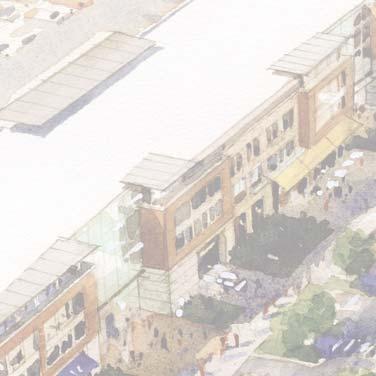
14 Bird s Eye Illustration of Envisioned Entertainment District xiv

15 Area 2 Transit-Oriented Residential Development Master Plan Alternative While there is no train station planned at this time, the concept shown below was developed to illustrate what transit-oriented residential development might look like in the Touhy Triangle if Niles were to get its own commuter rail station in the future HOWARD ST NEW STREET C C ii C D Plan Notes i A B SUB-AREA 1 ( 30.6 DU/AC) 4-Story Residential 60 units (± 1,000 sf typ.) 1 ground-floor space/unit 1.9 parking spaces/unit total 4-Story Residential 45 units (± 1,000 sf typ.) 1 ground-floor space/unit 1.9 parking spaces/unit total ii C D E iii F SUB-AREA 2 ( 21.4 DU/AC) 3-Story Residential 36 units (± 1,000 sf typ.) each 1.4 parking spaces / unit total 2 to 3-Story Townhomes 17 units (± 2,000 sf typ.) 2 private garage spaces / unit 12 additional guest parking spaces Re-Routed Gross Point Road SUB-AREA 3 ( DU/AC) 3-Story Residential 42 units (± 1,000 sf typ.) each 1.4 parking spaces / unit total GROSS POINT ROAD i A F F iii E H I Possible Location for Future Station LEHIGH AVE G H I 3-Story Residential 36 units (± 1,000 sf typ.) 1.3 parking spaces / unit total 1-Story Clubhouse: 6,500 square feet 65 overflow parking spaces Shared amenities & open space 2 to 3-Story Townhomes 32 units (± 2,000 sf typ.) 2 private garage spaces / unit A B F G 48 additional guest parking spaces COSTCO NEW BOULEVARD Option: Increased Indoor Parking 3-story buildings could become 4-story,with 1 internal ground-floor space per unit. xv


16 Development Character The images shown below and on the facing page provide some examples of the type of development character envisioned as part of the proposed master plan. These potential development products reflect typical land uses and building types that are found in similar settings both regionally and nationally. The applicable development area is noted in the upper right corner of each of the potential building types shown. Mixed-Use Development Entertainment-oriented uses front an active public open space at MB Financial Park in Rosemont, Illinois. Eddy Commons in South Bend, Indiana uses residential and commercial development to line a large, internal parking deck. Walnut Flats in Denver, Colorado is an example of a contemporary mixed-use development located near the City s ballpark. Hotel Commercial A mid-rise hotel development at Randhurst Village in Mount Prospect, Illinois. xvi Low-rise commercial development that focuses on dining & entertainment-oriented use, with ample outdoor seating areas. Larger-format commercial anchors that serve as retail destinations, bringing people to the Touhy Triangle.


17 Office Industrial / Manufacturing Low-rise office developments with smaller footprints provide a transitional use and accommodate infill sites. Temperance Brewery in Evanston, Illinois is an example of a light-industrial use with an active, commercial component. Manufacturing and light-industrial uses should have appropriate landscaping and clearly identifiable entrances oriented towards public right-of-ways YMCA Residential A modernized YMCA with an aquatic center and a variety of amenities could act as a major destination within the Touhy Triangle. Mid-rise residential developments provide density that supports nearby commercial and entertainment-oriented uses. The North Center Senior Campus in Chicago is an example of a residential campus development set within an active urban area. xvii

18 Open Space Character New community open spaces are at the heart of both the preferred and alternate plans for the proposed Touhy Triangle entertainment district. In either concept, the proposed spaces are intended to be active and inviting, with unique elements and attractive landscaping and furnishings that help to attract visitors and promote the area as a destination. In the preferred scheme, a large community green provides space for a performance venue and art installations. Examples of similar open spaces as those proposed in this plan, as well as some potential amenities that could be included are shown on the following page. Eye-Level Illustration of Envisioned Open Space An artist s illustration of the envisioned entertainment district open space looking south. xviii


19 Open Space Elements A park shelter in Winnetka s Hubbard Woods District doubles as a stage for performances and events. Focal elements at the ends of the open areas serve as landmark features and create visual interest. Emphasize the Leaning Tower of Niles is a focal point. photo by Miroslaw Mucha - Wikipedia Food trucks and kiosks with outdoor dining areas provide informal commercial opportunities that can be incorporated into open spaces. Interactive elements such as splash pads help to generate activity and excitement without being visually obtrusive. Incorporate unique elements and features to help promote the new district as a destination. xix
Village of Niles, Illinois TOUHY TRIANGLE MASTER PLAN. Gewalt Hamilton Associates
 Village of Niles, Illinois Gewalt Hamilton Associates NOVEMBER 2016 Contents Plan Purpose 3 Plan Overview 3 Existing Conditions 4 Study Area Context 4 Transportation Context 6 Development Context 12 The
This Review Is Divided Into Two Phases:
 Semiahmoo Town Centre Review The purpose of this review: To review the Semiahmoo Town Centre Concept Plan, originally approved in 1993, to ensure that this centre will continue to serve the needs of South
Hockessin Community Redevelopment Plan
 Hockessin Community Redevelopment Plan 3.1 Introduction The Community Redevelopment Plan for the Village of Hockessin is the result of the people s vision for a distinct village center that serves as the
Town Center (part of the Comprehensive Plan)
") Town Center (part of the Comprehensive Plan) Mercer Island Town Center Looking North (2014) In 1994, a year-long process culminated in a set of design guidelines and code requirements for the Town Center
Town Center (part of the Comprehensive Plan) Mercer Island Town Center Looking North (2014) In 1994, a year-long process culminated in a set of design guidelines and code requirements for the Town Center
PLAN ELEMENTS WORKSHOP. April 5, 2016
 PLAN ELEMENTS WORKSHOP April 5, 2016 needs more housing. But there is no one-size fits-all solution. Every neighborhood has its own character. In some places, density is not only appropriate it is badly
DRAFT ROOSEVELT ROAD. District Recommendations. Figure 5.23 The Roosevelt Road Corridor
 CHAPTER 5 Figure 5.23 The Road Corridor Road will develop as a mixed-use corridor, emphasizing regional retail, west of the river and mixed-use development east of the river. KEY RECOMMENDATIONS 1. High
Urban Design Brief December 23, 2015 Southside Construction Group Official Plan & Zoning By-Law Amendment
 Urban Design Brief Proposed Official Plan & Zoning By-Law Amendment 3244, 3263 and 3274 Wonderland Road South Southside Group December 23, 2015 TABLE OF CONTENTS Page No. INTRODUCTION... 1 SECTION 1 LAND
Neighborhood Districts
 NEIGHBORHOOD DISTRICTS SEVEN MAIN DISTRICTS Neighborhood Districts While the Development Plan provides a broad-scale overview of the neighborhood, this section focuses on uses and relationships at the
THE NEIGHBORHOOD TODAY
 THE NEIGHBORHOOD TODAY CORE AREA VISION How are we Good Urbanism A Site s DNA thinking about Elements of great Unique elements urban communities embedded in a place the site and design? ELEMENTS LIKE:
03 HIGH PRIORITY SITES
 03 HIGH PRIORITY SITES HOWARD PARK Howard Park is one of South Bend s largest riverfront parks, hosting nearly acres. Howard Park has a very passive landscape with a recreation building, ice skating rink,
Lehigh Acres Land Development Regulations Community Planning Project
 Lehigh Acres Land Development Regulations Planning Effort Summary In July, 2010 Commissioner Frank Mann invited the Lehigh Acres community to start discussing how to achieve their recently adopted community
Subarea 4 Indian Creek. Vision The combination of park networks and transportation amenities make Subarea 4 the greenest hub in the Corridor.
 indian creek 180 extends south from 101st Street to I-435. The I-435 and Metcalf intersection is one of the primary intersections in the Kansas City Metro Area. The area includes several residential neighborhoods
3.0 URBAN DESIGN. December 6, OVERVIEW
 Urban Design 3.0 URBAN DESIGN December 6, 2007 3.1 OVERVIEW The highly urban character of Easton Place is defined by the overall design of the community. The following sections provide an overview of the
2.0 THE PLATINUM TRIANGLE VISION
 2.0 THE PLATINUM TRIANGLE VISION The envisions an exciting future for the area surrounding Angel Stadium of Anaheim, the Honda Center and The Grove of Anaheim. 2.1 Planning Principles In order to further
EXISTING COMPREHENSIVE PLAN
 EXISTING COMPREHENSIVE PLAN Town Center Land Use Element: V. LAND USE POLICIES Town Center Mercer Island's business district vision as described in "Your Mercer Island Citizen-Designed Downtown" was an
Developer s Program. The Station at East 54
 Developer s Program The Station at East 54 Existing Conditions The Station at East 54 is proposed for a 1.12 acre site at the northeast corner of Hamilton Road and Prestwick Road, tucked between the East
Westbound: A One-day Exploration of Growth
 Westbound: A One-day Exploration of Growth Frog Pond Area 2018 UGB Expansion Proposal June 13, 2018 Growing Out: UGB Asks Four cities submitted proposals to expand greater Portland s urban footprint by
The transportation system in a community is an
 7 TRANSPORTATION The transportation system in a community is an important factor contributing to the quality of life of the residents. Without a sound transportation system to bring both goods and patrons
Gold Line Bus Rapid Transit Transit Oriented Development (BRTOD) Helmo Station Area Plan
 Helmo Station Area Plan") Appendix F Gold Line Bus Rapid Transit Transit Oriented Development (BRTOD) Helmo Station Area Plan Introduction and Purpose of the Plan The Gold Line Bus Rapid Transit facility is an eleven-mile dedicated
Appendix F Gold Line Bus Rapid Transit Transit Oriented Development (BRTOD) Helmo Station Area Plan Introduction and Purpose of the Plan The Gold Line Bus Rapid Transit facility is an eleven-mile dedicated
Sahuarita District & Phase 1 Master Plan. Town Council December 11, 2017
 Sahuarita District & Phase 1 Master Plan Town Council December 11, 2017 Visioning Study Visioning Process Advisory Group Meetings Community Questionnaire Town Center Case Studies Community Analysis The
Civic Center District
 Civic Center District The Civic Center district is the civic and social heart of Warrenville, containing such public buildings as the City Hall, Warrenville Public Library, Police Station, Park District
Planning Districts INTRODUCTION
 INTRODUCTION To facilitate detailed examination of development prospects for all areas of the community, Delano has been divided into 14 planning districts. The location of these planning districts is
Transportation. Strategies for Action
 Transportation A major priority for the Overlake Neighborhood is to develop a multimodal transportation system. To achieve this system, a balance has to be found among travel, circulation and access needs;
Queensborough Eastern Neighbourhood Node. Community Open House
 Queensborough Eastern Community Open House The Vision The Queensborough Eastern will become the heart of eastern Queensborough. Through a sensitive mix of viable commercial and residential areas, the neighbourhood
Ivywild On The Creek PRELIMINARY CREEK DISTRICT MASTER PLAN
 Ivywild On The Creek PRELIMINARY CREEK DISTRICT MASTER PLAN Introduction: Rejuvenating an extraordinary Creekside neighborhood THE CREEKSIDE DISTRICT The Ivywild On The Creek Neighborhood District Master
Wadsworth Boulevard S TAT I O N A R E A P L A N
 Wadsworth Boulevard S TAT I O N A R E A P L A N City of Lakewood Adopted November, 2006 The Vision The City of Lakewood s overall vision is to transform the area around the light rail station into a mixed-use
DALY CITY VISIONING PROCESS COMMUNITY WORKSHOP 3 MAY 8, 2008
 DALY CITY VISIONING PROCESS COMMUNITY WORKSHOP 3 MAY 8, 2008 PROCESS General Plan - a statement of the community s values, vision and aspirations for now and into the future... Timeframe LONG TERM - 2030
Town Center. Block 5 Existing multifamily residential units are expected to remain.
 Area Guidelines Germantown s districts should be developed as distinct communities with unique features that are supported through the guidelines. The guidelines not only help distinguish these districts
Prosperity Hucks Area Plan. Transportation and Planning Committee May 11, 2015
 Prosperity Hucks Area Plan Transportation and Planning Committee May 11, 2015 Presentation Outline 1. Background and Location 2. Community Dialog Process 3. Activity Center Recommendations 4. Wedge Recommendations
6. DOWNTOWN. The Downtown Element focuses on supporting and expanding the vitality and enhancement of Downtown Chico as the City s central core.
 VISION In 2030, Downtown Chico is the heart of the community and the center of cultural activity. Engaging and active at the street level, it is a multi-story, mixed-use hub, with specialty retail, restaurants,
WELCOME and introduction
 1 WELCOME and introduction Mobility Hub Locations within Burlington STUDY OVERVIEW STUDY OBJECTIVES The City of Burlington is developing four Area Specific Plans, one for each of Burlington s Mobility
Policies and Code Intent Sections Related to Town Center
 Policies and Code Intent Sections Related to Town Center The Town Center Vision is scattered throughout the Comprehensive Plan, development code and the 1994 Town Center Plan. What follows are sections
Westwind Developments Ltd. PIONEER LANDS AREA STRUCTURE PLAN - PROPOSED AMENDMENT
 FEBRUARY 2013 TABLE OF CONTENTS 1.0 BACKGROUND... 1 1.1 Amendment... 1 2.0 LOCATION & CONTEXT... 2 2.1 Land Ownership... 2 3.0 POLICY CONTEXT... 3 3.1 Municipal Development Plan... 3 3.2 Capital Region
Metro. Activity Center Design Guidelines. Recommendations For Developing Focused, Mixed-Use Commercial/Residential Centers
 Metro Activity Center Design Guidelines Recommendations For Developing Focused, Mixed-Use Commercial/Residential Centers Metro Activity Centers What is a MAC? Legacy, the adopted guide for the future growth
Sub Area 2: Downtown Overland Park
 Downtown 132 2.12 encompasses over 600 acres and extends between 71st Street and 87 th Street including Downtown Overland Park. The area is home to several individual historic sites and structures, including
Sheridan Boulevard S TAT I O N A R E A P L A N S H E R I D A N B O U L E VA R D S TAT I O N A R E A P L A N
 Sheridan Boulevard S TAT I O N A R E A P L A N 1 City of Lakewood Adopted November, 2006 S H E R I D A N B O U L E VA R D S TAT I O N A R E A P L A N The Vision The City of Lakewood s overall vision is
3.1 Existing Land Use
 3.0 Land Use This strategy has been developed taking into account the position of the Town of Sidney as the economic center of the Saanich Peninsula. It acknowledges existing land use patterns in the downtown
CONTENTS 6.1 URBAN DESIGN
 6-2 Urban Design and Sustainable Development 6.0 URBAN DESIGN AND SUSTAINABLE DEVELOPMENT CONTENTS 6.1 URBAN DESIGN 6.1.1 General Policies 6.1.2 The Public Realm 6.1.3 Streets and Blocks 6.1.4 Streetscapes
The University District envisions, in its neighborhood
 Envisioning the University District Link Light Rail in Seattle s neighborhoods CIY OF SEALE CONCEP-LEVEL SAION AREA PLANNING RECOMMENDAION RESOLUION # 30165 EXHIBI L Vision 08.2000 he University District
Planning Board Briefing
 Planning Board Briefing Why Now? The Sector Plan Implementation Chapter States: Before Stage 1 begins, the following must occur: Approval of the Sectional Map Amendment. Approval of the Greater Lyttonsville
St. Kevin s Area Planning Collaborative
 Table of Contents page 2 EXECUTIVE SUMMARY 3 MISSION STATEMENT 4 NEIGHBORHOOD CONTEXT 6 STREET CHARACTER 7 SITE PARAMETERS 9 COMMUNITY CHARRETTE - VISIONING GROUP TABLE 1 11 GROUP TABLE 2 12 GROUP TABLE
CITY OF PUYALLUP. Background. Development Services
 CITY OF PUYALLUP Development Services 333 South Meridian Puyallup WA 98371 To: City Council From: Katie Baker, AICP, Planning Division Re: South Hill Neighborhood Plan Adoption Date: (Meeting date: February
BROOKHILL NEIGHBORHOOD MODEL ZONING MAP AMENDMENT PREFACE TO APPLICATION
 BROOKHILL NEIGHBORHOOD MODEL ZONING MAP AMENDMENT PREFACE TO APPLICATION June 15, 2015 Revised: August 1, 2016 I. VISION Brookhill is a proposed community based upon the principles of Albemarle County
North Oakville East Parks Facilities Distribution Plan. November, 2009
 North Oakville East November, 2009 POLICY CONTEXT 1) Purpose a) The purpose of this document is to be a guide for the location, configuration, design and development of the parks system for the North Oakville
Land Use. Hardware Street Vendor Mixed-Use
 Land Use Definition Land Use is the way a piece of real estate is utilized. Existing, proposed, and adopted land uses all play a role in the planning process. Once a land use plan is adopted, the next
Urban Design Manual PLANNING AROUND RAPID TRANSIT STATIONS (PARTS) Introduction. Station Study Areas
 Introduction. Station Study Areas") 111111 PLANNING AROUND RAPID TRANSIT STATIONS (PARTS) Introduction The ION rapid transit system will link Waterloo, Kitchener and Cambridge through a central transit corridor (CTC). There are a number
111111 PLANNING AROUND RAPID TRANSIT STATIONS (PARTS) Introduction The ION rapid transit system will link Waterloo, Kitchener and Cambridge through a central transit corridor (CTC). There are a number
DOMINION BOULEVARD CORRIDOR STUDY AND ECONOMIC DEVELOPMENT STRATEGIC PLAN A MODEL FOR CHESAPEAKE S FUTURE
 DOMINION BOULEVARD CORRIDOR STUDY AND ECONOMIC DEVELOPMENT STRATEGIC PLAN A MODEL FOR CHESAPEAKE S FUTURE Overview I. Draft Plan Process II. Draft Plan Overview a. Market Analysis b. Master Land Use Plan
Silverdale Regional Center
 Silverdale Regional Center Vision for Silverdale Regional Center The Silverdale Regional Center Plan (Plan) will guide the evolution of the Silverdale Regional Center from a collection of strip malls and
Seneca Meadows. Block 4 Locate office, technology, and medical development adjacent to I Screen views of garage structures from I-270.
 Seneca Meadows Seneca Meadows has an industrial park in its southern end and a mixed-use employment area planned for the north end. The district benefits from extensive I-270 visibility, stream valley
DRAFT. October Wheaton. Design Guidelines
 October 2011 DRAFT Wheaton Design Guidelines 2 Draft - Design Guidelines - Wheaton Sector Plan Contents 04 Section 1: Introduction 06 Section 2: Context 08 Section 3: Design Guidelines 09 Goal 1: Create
Courthouse East vision and policy plan
 August 2017 Courthouse East vision and policy plan Virginia Beach, Virginia 2017 URBAN DESIGN ASSOCIATES SITE PLANNING APPROACH 10-minunte walk from the Courthouse COURTHOUSE EAST IN THE ITA VICINITY Site
and services The protection and conservation of environmentally significant and sensitive natural heritage features and functions.
 6. Land Use 6.0 Preamble A healthy and livable city is one in which people can enjoy a vibrant economy and a sustainable healthy environment in safe, caring and diverse neighbourhoods. In order to ensure
5.1 Site Plan Guidelines
 5. Community Core Guidelines Development of the Community Core will take place by plan of subdivision and site plan approval. It will occur in a phased manner that will reflect the timing of residential
The Village. Chapter 3. Mixed Use Development Plan SPECIFIC PLAN
 The Village SPECIFIC PLAN Chapter 3 3.1 INTRODUCTION 3.1.1 Purpose This Chapter describes the development regulations applicable to the Mixed-Use and Transit Center Planning Areas. These form-based regulations
GAMMAGE SQUARE - RECOMMENDATIONS
 GAMMAGE SQUARE - RECOMMENDATIONS We envision an expanded cultural district surrounding the historic ASU Gammage. Creating a cultural district will enhance the existing historic landmark by activating the
FRUITVALE TRANSIT VILLAGE (Phase 2) Residential Project
 Residential Project") FRUITVALE TRANSIT VILLAGE (Phase 2) Residential Project DEVELOPER: SIGNATURE PROPERTIES ARCHITECT: HKIT ARCHITECTS April 23, 2010 TABLE OF CONTENTS 3 Vision 4 Description of Site 5 Guiding Concepts 6
FRUITVALE TRANSIT VILLAGE (Phase 2) Residential Project DEVELOPER: SIGNATURE PROPERTIES ARCHITECT: HKIT ARCHITECTS April 23, 2010 TABLE OF CONTENTS 3 Vision 4 Description of Site 5 Guiding Concepts 6
VISION, GOALS & CONCEPT DIAGRAM 2.0
 CHAPTER 2.0 2.1 Vision Creation Process 2.2 City Center Vision Statement, Goals and Objectives 2.3 Individual Zone Visions 2.4 Steps in City Building 2.5 Urban Form Concept Diagram for City Center VISION,
MALL REVITALIZATION CASE STUDIES
 MALL REVITALIZATION CASE STUDIES DECEMBER 9, 2012 MALL REVITALIZATION OVERVIEW Introduction Sample Case Studies prepared for Lacey Woodland District Steering Committee as it considers strategies to revitalize
Comprehensive Plan ADOPTED APRIL 2014
 Comprehensive Plan ADOPTED APRIL 2014 8 8. Outstanding Recreational & Cultural Opportunities We are proud of our community s parks and recreation system. Our community will ensure that the legacy of our
Table of Contents. Elm Avenue Improvement Plan City of Waco, Texas. Introduction 1. Existing Context 1 Figure 1 2.
 Table of Contents Introduction 1 Existing Context 1 Figure 1 2 Plan Guidelines 3 Future Urban Form 4 The West-End 4 Main Street 6 The East-End 7 Figure 2 9 Public Improvement Recommendations 7 General
FLORIN ROAD CORRIDOR Site Plan and Design Review Guidelines Checklist
 FLORIN ROAD CORRIDOR Site Plan and Design Review Guidelines Checklist Applicant s Name: Project Address: Phone: Email: Applicant shall fill out the design guidelines checklist for all guidelines applicable
KEIZER STATION PLAN INTRODUCTION
 KEIZER STATION PLAN INTRODUCTION Planning for this area began in 1987 when the Keizer Comprehensive Plan established the Chemawa Activity Center and McNary Activity Center. The first Chemawa Activity Center
APPENDIX C. Architectural and Environmental Design Standards. Environmentally sensitive areas should be protected.
 APPENDIX C Architectural and Environmental Design Standards Environmentally Sensitive Areas Goal A. Environmentally sensitive areas should be protected. Development, such as roads, houses, and other structures,
Welcome. Community Consultation Meeting November 28, Review and discuss the Bathurst Quay Neighbourhood Plan Framework
 Welcome Community Consultation Meeting November 28, 2016 Why Are We Here Today? Review and discuss the Bathurst Quay Neighbourhood Plan Framework Review and discuss an Action Plan for Implementation Next
[PLANNING RATIONALE] For Site Plan Control and Lifting of Holding Zone By-Law 101 Champagne Avenue. May 23, 2014
![[PLANNING RATIONALE] For Site Plan Control and Lifting of Holding Zone By-Law 101 Champagne Avenue. May 23, 2014](/thumbs/75/71599615.jpg "[PLANNING RATIONALE] For Site Plan Control and Lifting of Holding Zone By-Law 101 Champagne Avenue. May 23, 2014") [PLANNING RATIONALE] For Site Plan Control and Lifting of Holding Zone By-Law 101 Champagne Avenue May 23, 2014 Contents 1.0 Introduction... 2 2.0 Site Context... 2 2.1 Adjacent Uses... 2 Figure 1: Site
[PLANNING RATIONALE] For Site Plan Control and Lifting of Holding Zone By-Law 101 Champagne Avenue May 23, 2014 Contents 1.0 Introduction... 2 2.0 Site Context... 2 2.1 Adjacent Uses... 2 Figure 1: Site
John M. Fleming Managing Director, Planning and City Planner. Old East Village Dundas Street Corridor Secondary Plan Draft Terms of Reference
 Report to Planning and Environment Committee To: From: Subject: Chair and Members Planning & Environment Committee John M. Fleming Managing Director, Planning and City Planner Old East Village Dundas Street
FORMER CANADIAN FORCES BASE (CFB) ROCKCLIFFE SECONDARY PLAN. Official Plan Amendment XX to the Official Plan for the City of Ottawa
 ROCKCLIFFE SECONDARY PLAN. Official Plan Amendment XX to the Official Plan for the City of Ottawa") FORMER CANADIAN FORCES BASE (CFB) ROCKCLIFFE SECONDARY PLAN Official Plan Amendment XX to the Official Plan for the City of Ottawa 1 INDEX THE STATEMENT OF COMPONENTS PART A THE PREAMBLE PAGE Purpose...
FORMER CANADIAN FORCES BASE (CFB) ROCKCLIFFE SECONDARY PLAN Official Plan Amendment XX to the Official Plan for the City of Ottawa 1 INDEX THE STATEMENT OF COMPONENTS PART A THE PREAMBLE PAGE Purpose...
URBAN DESIGN BRIEF URBAN DESIGN BRIEF 721 FRANKLIN BLVD, CAMBRIDGE August 2018
 URBAN DESIGN BRIEF URBAN DESIGN BRIEF 721 FRANKLIN BLVD, CAMBRIDGE August 2018 DESIGN BRIEF CONTENTS PART A 1.0 INTRODUCTION 2.0 DESCRIPTION & ANALYSIS OF SITE CONTEXT 3.0 DESIGN CONSTRAINTS AND OPPORTUNITIES
SECTION IV: DEVELOPMENT CONCEPT
 80 SECTION IV: DEVELOPMENT CONCEPT Section IV: DEVELOPMENT CONEPT This section provides an overall understanding and rationale for what is envisioned in The Preserve, the intended quality and character
DENVER DESIGN DISTRICT GDP
 DENVER DESIGN DISTRICT GDP Urban Design Standards and Guidelines November 17, 2008 Amended February 3, 2016 City and County of Denver CF Property Management, Inc. C/O Denver Design District - Starboard
City of Toronto. Emery Village Transportation Master Plan
 City of Toronto Emery Village Transportation Master Plan May 2009 Emery Village Transportation Master Plan Toronto, ON May 2009 Consulting Inc. 100 York Blvd., Suite 300 Richmond Hill, ON L4B 1J8 Tel:
4- PA - LD - LIVELY DOWNTOWN. LD - Background
 4- PA - LD - LIVELY DOWNTOWN LD - Background The downtown has been the service centre for the community since the city s inception and the area continues to supply people with their personal services,
U T D N o r t h C a m p u s T O D and D o w n t o w n D e n t o n T O D
 U n i v e r s i t y o f T e x a s a t D a l l a s C i t y o f R i c h a r d s o n U T D N o r t h C a m p u s T O D and D o w n t o w n D e n t o n T O D Rick Leisner, AICP Assistant Director of Development
Danvers High Street I-1 District Study
 Danvers High Street I-1 District Study Presentation of Final Recommendations Planning Board Presentation June 26 th, 2018 1 Introductions Metropolitan Area Planning Council Sam Cleaves AICP, Principal
Plano Tomorrow Vision and Policies
 Plano Tomorrow Vision and Policies PLANO TOMORROW PILLARS The Built Environment The Social Environment The Natural Environment The Economic Environment Land Use and Urban Design Transportation Housing
AMENDMENT NO. 42 TO THE OFFICIAL PLAN OF THE TOWN OF GRIMSBY
 AMENDMENT NO. 42 TO THE OFFICIAL PLAN OF THE TOWN OF GRIMSBY INITIATED BY TOWN OF GRIMSBY TABLE OF CONTENTS PART I: THE CERTIFICATION Certification Page Adopting By-law of the Town of Grimsby PART II:
Derry Green Corporate Business Park
 Town of Milton Derry Green Corporate Business Park Urban Design Guidelines BMI/Pace - June 2010 Draft 3 Prepared by: Brook McIlroy Planning + Urban Design / Pace Architects Suite 300-51 Camden Street Toronto,
Behnke Ranch Property, Pasco County: Master Plan Development Approach
 February 24, 2014 , Pasco County: Master Plan Development Approach Location & Program The (Legacy PUD) is located in southwest Pasco County along State Road 54 approximately 1.5 miles west of the Suncoast
38 Queen s University Campus Master Plan Part 1
 38 Queen s University Campus Master Plan Part 1 46 The Campus at the City Scale Chapter 4 The Campus at the City Scale 39 Queen s is an urban University centrally located in Kingston. Decisions made by
Complete Neighbourhood Guidelines Review Tool
 Complete Neighbourhood Guidelines Review Tool Prepared By: City of Regina Planning Department October 2014 Page 1 of 14 Community Development Review Checklist for Secondary Plans and Concept Plans The
Draft Memorandum #1: Goals and Vision for Revitalization
 Keizer Revitalization Plan Draft Memorandum #1: Goals and Vision for Revitalization Submitted to: City of Keizer April 12, 2018 (revised) Prepared By: Angelo Planning Group and Otak, Inc. Project No. 17482.A
A Plan for the Heart of the Region: Tukwila, WA
 : Tukwila, WA 1 The Plan orchestrates the Restructuring of a 1,000-acre Regional Shopping Area into a Social and Symbolic for the Region. REGIONAL CONTEXT Downtown Seattle (Metropolitan ) 20 miles Bellevue
INSTITUTIONAL USE DESIGN COMPATIBILITY TECHNIQUES
 INSTITUTIONAL USE DESIGN COMPATIBILITY TECHNIQUES INTRODUCTION Community institutions are an important part of the character and vitality of neighborhoods in Forsyth County. Institutional uses include
SAN RAFAEL GENERAL PLAN 2040 INTRODUCTION AND OVERVIEW
 SAN RAFAEL GENERAL PLAN 2040 INTRODUCTION AND OVERVIEW Steering Committee Presentation February 14, 2018 Purpose of General Plan Guide land use and development decisions Coordinate transportation, infrastructure,
1.0 VISION STATEMENT. December 6, PRINCIPLES
 Vision Statement Lincoln Regional Airport 1.0 VISION STATEMENT 1.1 City LOCATION of AND OVERVIEW The Easton Lincoln Place Land Use Master Plan identifies the principles, goals, policies, and standards
Mark-up of the effect of the proposed Bronte Village Growth Area OPA No.18 on the text of section 24, Bronte Village, of the Livable Oakville Plan
 Mark-up of the effect of the proposed Bronte Village Growth Area OPA No.18 on the text of section 24, Bronte Village, of the Livable Oakville Plan Notes: This document is provided for information purposes
4.1.3 LAND USE CATEGORIES
 4.1.3 LAND USE CATEGORIES a. City Center District The City Center District incorporates the existing character and mix of uses in downtown Belmont to encourage redevelopment and new development in keeping
Northwest Rail Corridor and US 36 BRT Development Oriented Transit Analysis 4.4 STATION AREA FINDINGS
 4.4 STATION AREA FINDINGS Each station is different, and each one requires a separate set of recommendations based on the vision for the site. This section outlines an initial TOD strategy and recommendations
Allen Street Civic District Redevelopment Area Plan Redevelopment Plan & Proposal State College Planning Commission State College Redevelopment
 Allen Street Civic District Redevelopment Area Plan Redevelopment Plan & Proposal State College Planning Commission State College Redevelopment Authority September 17, 2015 Discussion Points Overview of
Workshop 3. City of Burlington Waterfront Hotel Planning Study. September 14, The Planning Partnership
 Workshop 3 City of Burlington Waterfront Hotel Planning Study September 14, 2017 The Planning Partnership The Waterfront Hotel Planning Study 01 The Brant & Lakeshore Planning Study will establish a Strategic
City of Long Beach. creating vibrant and exciting places
 City of Long Beach creating vibrant and exciting places Land Use Element Urban Design Element Overview of the two draft General Plan elements Discuss areas of change Economic goals of the plans Case study
EcoVerde MADISON TO DOWNTOWN TO BEACH. Legend Highway Major Connection Major Street Local Street Proposed Access. Response to Tropicana Field RFP
 EcoVerde TO BEACH 275 16th Street North 16th Street South 13th Street North 13th Street South 11th Street North 11th Street South 1st Avenue North Central Avenue 1st Avenue South TO DOWNTOWN 2nd Avenue
8. Urban Villages. Other Relevant Policies & Bylaws Official Community Plan Development Permit Area Designations and Guidelines
 8. Urban Villages Urban villages provide walkable shops and services, encourage a neighbourhood social life, create a sense of place and provide different housing options. More housing near Urban Villages
ARTICLE 6: Special and Planned Development Districts
 ARTICLE 6: Special and Planned Development Districts 6-10 Traditional Neighborhood Development (TND) District 6-10.10 Purpose and Intent The Traditional Neighborhood Development (TND) District provides
hermitage town center
 hermitage town center A Community Vision prepared by Strada for The City of Hermitage and The Mercer County Regional Planning Commission January 2007 table of contents introduction 3 design principles
KANATA CENTRUM 255 KANATA AVENUE OFFICIAL PLAN AMENDMENT ZONING BY-LAW AMENDMENT
 KANATA CENTRUM 255 KANATA AVENUE OFFICIAL PLAN AMENDMENT ZONING BY-LAW AMENDMENT JUNE 2015 PREPARED BY: FOTENN Consultants Inc. 223 Mcleod Street Ottawa, ON K2P OZ8 (613) 730-5709 PREPARED FOR: Kanata
Implementation Guide Comprehensive Plan City of Allen
 Implementation Guide 2030 Comprehensive Plan City of Allen DRAFT 2015 Implementation Guide Allen 2030 Comprehensive Plan INTRODUCTION The Comprehensive Plan serves as a guide for the growth and development
PROPOSED REDEVELOPMENT OF THE GLEN ABBEY GOLF CLUB. STREETSCAPE DESIGN STUDY (excerpt from the Urban Design Brief) TOWN OF OAKVILLE.
 TOWN OF OAKVILLE.") PROPOSED REDEVELOPMENT OF THE GLEN ABBEY GOLF CLUB STREETSCAPE DESIGN STUDY (excerpt from the Urban Design Brief) TOWN OF OAKVILLE OCTOBER, 2016 for 2.4.2 STREETS Streets are the single largest component
PROPOSED REDEVELOPMENT OF THE GLEN ABBEY GOLF CLUB STREETSCAPE DESIGN STUDY (excerpt from the Urban Design Brief) TOWN OF OAKVILLE OCTOBER, 2016 for 2.4.2 STREETS Streets are the single largest component
DRAFT. 10% Common Open Space
 % OF CHARLOTTE IS CATEGORIZED AS A. LAND USES : Placeholder map displaying location of Place Type GOALS: Accommodate XX% of future growth. Provide a concentration of primarily commercial and civic activity
FUTURE LAND USE ELEMENT
 FUTURE LAND USE ELEMENT GOAL I: To create and sustain a great place to live, play, and prosper Objective 1: The City of Ocala shall incorporate the principles and strategies of the Ocala 2035 Vision into