After the Storms: Planning for Louisiana s Future. Larry Ardoin Coastal Protection and Restoration Authority Integrated Planning Team
|
|
|
- Jayson Brown
- 5 years ago
- Views:
Transcription

1 After the Storms: Planning for Louisiana s Future Larry Ardoin Coastal Protection and Restoration Authority Integrated Planning Team
2 Today s Presentation Background Objectives Draft Master Plan Upcoming Schedule
3 Background
4 Hurricane Katrina the most destructive hurricane to ever strike the U.S. NOAA
5 Hurricane Rita Rita was the third most intense hurricane ever in the Atlantic Basin behind Hurricane Gilbert in 1988 and the 1935 Labor Day Hurricane NOAA
6 LA DOTD
7 So what does all this mean to Louisiana?
8 Over 65% of the population of Louisiana. lives within 50 miles of the coast (over 2 million according to 2000 census)
9 Why do we live where we do?
10 Louisiana s Economy is Concentrated in the Southern Region of the State 73.5 % of state employment Almost 60% of oil and gas employment 77% of construction employment 67% of all manufacturing employment in the state.
11 Commerce and Trade US Army Corps of Engineers Navigation Data Center
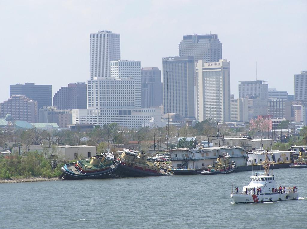
12 Commerce and Trade The hurricane also disrupted operations at the Port of South Louisiana and the Port of New Orleans. Together, these ports account for $150 billion and 20 percent of U.S. import/export cargo traffic annually Department of Commerce Service Assessment, NOAA, Hurricane Katrina August 23-31, 2005 photo LA DOTD
13 Sea Ports are also River Ports Sept. 16, 2005, 11:36PM KATRINA'S AFTERMATH Corn farmers feel storm's aftershocks Disabled ports lead to clogged shipping lines By JIM SUHR Associated Press COLUMBIA, ILL. - His face smudged with dark grit, Glen Mueller stepped down from a mammoth combine this week and stared out cross a corn crop jeopardized by quandaries far larger than the machinery towering over him. He and other farmers are facing a double whammy as the harvest begins. The record yields of last year are a faded memory, replaced by crops parched, browned and thinned by months of drought. And now, damage done by Hurricane Katrina threatens to push up the cost and create delays in getting this year's crop to export terminals down the Mississippi River. Houston Chronicle Port of New Orleans Port of South Louisiana Port of Baton Rouge as of August 2005, these three ports serve as a gateway for nearly 55 to 70 percent of all U.S. exported corn, soy, and wheat North American Export Grain Association And now, damage done by Hurricane Katrina threatens to push up the cost and create delays in getting this year's crop to export terminals down the Mississippi River.
14 Energy
15 Based on its energy producing value to the nation, acre for acre, Louisiana is the most valuable real-estate in the nation. Scott Angelle Secretary, Louisiana Department Natural Resources in testimony before the Committee on Resources, U.S. House of Representatives

16 Commercial Seafood Landings The Times-Picayune

17 Source: NOAA Fisheries 2004

18 Louisiana s Coastal Harvest is More than Oil, Gas and Seafood Sugar Cane Rice Soybeans Cotton Cattle Citrus Timber Crawfish Alligator photo courtesy La Dept. Agriculture & Forestry and others


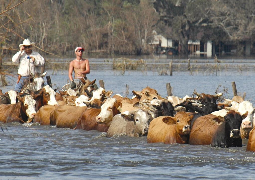
19 The total value of the sales from Louisiana beef cattle in 2005 was $406.4 million. Louisiana cattle producers have more than 1 million acres in pasture and hay production. Louisiana s herd is estimated in excess of 600,000 head raised by more than 12,000 producers. About 8,000 head of cattle in Cameron parish alone were estimated lost due to Rita. About 35,000 head of cattle lost coast wide in south Louisiana from both storms. photos courtesy La Dept. Agriculture & Forestry and others
20
21 What are we doing?
22 Three Planning Efforts State directed Coastal Protection & Restoration Authority Master Plan (CPRA) Congressionally directed USACE Louisiana Coastal Protection Report (LaCPR) State established Louisiana Recovery Authority (LRA) and its Louisiana Speaks Initiative


23 Ongoing Planning Efforts
24 Coastal Protection and Restoration Authority Established in December 2005 by the Louisiana legislature through Act 8 of the First Extraordinary Session of 2005 LA DNR
25 Act 8 of the Louisiana Legislature First Extraordinary Session of 2005 hurricane protection is vital to survival Coastal land loss in Louisiana continues in catastrophic proportions Hurricane protection and coastal restoration must be integrated to achieve a long-term solution of coastal protection.
26 Act 8 of the Louisiana Legislature First Extraordinary Session of Mandated an integrated team effort to jointly coordinate master plan development with federal agencies and political subdivisions, including levee districts 2005


")

27 CPRA Integrated Planning Team (IPT) As charged by Act 8, the CPRA established an Integrated Planning Team (IPT). Team consists of expert staff from the LA DNR and DOTD Jointly coordinates development of a master plan with state agencies, federal agencies, and political subdivisions (including levee districts) Includes a liaison from the U.S. Army Corps of Engineers, New Orleans District
28 Act 8 of the Louisiana Legislature First Extraordinary Session of 2005 Produce a long-term comprehensive coastal protection plan combining hurricane protection and the protection, conservation, restoration, and enhancement of coastal wetlands and barrier shorelines or reefs

29 Act 8 of the Louisiana Legislature First Extraordinary Session of 2005 shall address hurricane protection and coastal restoration efforts from both shortterm and long-range perspectives shall incorporate structural, management, and institutional components of both efforts
30 Plan Objectives


31 Reduce Risk to Communities Courtesy of USACE Courtesy of Shirley Laska, CHART, UNO Digital Globe


32 Restore Sustainability to the Coastal Ecosystem Caernarvon Diversion Clay deposition on organic marsh surface


33 Maintain a Diverse Array of Fish and Wildlife Habitats


34 Sustain Louisiana s Unique Heritage and Culture Scott Russell Scott Russell
35 Master Plan Timeline Formation of IPT Feb 2006 First Plan Formulation Workshops May 2006 First Plan Formulation Report Jun 2006 Stakeholder Meetings Initiated Jul 2006 Second Plan Formulation Workshops Oct 2006 Release Preliminary Draft Master Plan Nov 2006 Public, Scientific, and Technical Review Dec Jan 2007 Release Draft Master Plan Feb 2007 Public Hearings/Meetings Feb 2007 Submit Final Master Plan to Legislature Apr 2007
36 State Coastal Protection Master Plan Policy, legislative, and institutional recommendations for change to remove impediments to implementation. Must be explicitly stated and addressed as part of implementation process. Must include federal initiatives, including implementation processes for USACE projects and programs. A baseline schedule for planning, design, and construction activities. To be in the annual plan. To facilitate long-range planning, policy, and funding decisions.
37 Listening and Focusing Program Coordination Utilized inputs from pre-storm planning efforts Leveraged post-storm planning and technical analyses from Corps of Engineers and Louisiana Recovery Authority Stakeholder participation Nearly 3 dozen focused stakeholder meetings 2 Interdisciplinary Technical Team Workshops, each attended by approximately 100 technical stakeholders Additional participation from technical experts in State and Federal resource agencies Formal Scientific and Engineering Review Louisiana Coastal Area Ecosystem Restoration Science Board Science and Engineering Review Team Public information and involvement Web site and electronic newsletter Nine public meetings on Preliminary Draft Plan
38 What Have We Learned? Concurrent public and scientific/technical review highlights issues: The public s protection and restoration expectations may not always be achievable. Protection measures may not be the best way to meet restoration objectives. Scale of necessary restoration actions will shift natural resource distribution. There is a great need for rapid advances in science and technology. There is great need for enhanced dialogue between scientists, planners, and the public.

39 The Draft Master Plan
40 Report Contents Main Report Appendix A Final Plan and Implementation Appendix B Preliminary Draft Plan Formulation Process (Nov 2006) Appendix C Public Comment on Preliminary Draft Plan Appendix D Sustainable Management and Mississippi River Resource Availability Appendix E Hurricane Surge Analysis Appendix F Economic Analysis Appendix G Coastal Louisiana Ecosystem Assessment and Restoration (CLEAR) Report Appendix H Alternative Plan Formulation Process (May 2006) Appendix I Measures Appraised: Alternative Plans 1 and 2 (May 2006) Appendix J Glossary of Terms Appendix K Bibliography
41 Restoring Sustainability to the Coastal Landscape Restoration of system hydrology Land-building diversions Land-sustaining diversions Navigation channels used to convey water Marsh creation with dredged material Barrier island and shoreline restoration Ridge habitat restoration Shoreline stabilization
42 Sustainable Delta Plain
43 Sustainable Chenier Plain
44 Reduce Risk to Communities Restored ecosystem Levees and flood gates Non-structural measures Elevated homes and businesses Improved building codes Evacuation planning Land-use planning Insurance Hazard mitigation plan implementation

45 Reduce Risk to Communities

46 Reduce Risk to Communities
47 Identified Barriers Rapid plan implementation is dependent on resolving several key policy, legislative, and institutional issues: Must develop structure for Master Plan implementation to maintain focus and integration of the program (Integrated Planning Team was an interim method used to compile the plan). Must focus Federal involvement in plan implementation, including process modifications to speed implementation. Effective mechanisms for focused land use regulation is needed to maintain program effectiveness (must avoid inducing development in unsafe areas). Must develop fair, equitable and expedient methods for acquiring surface land rights for project implementation. Must articulate a strategy for preserving and managing our wetland forests.
48 Program Management An adaptive implementation framework Focus scientific, engineering and technical advances. Assess plan implementation performance. Promote program learning. Revise the Master Plan, if necessary, in a deliberate manner while maintaining focus. Process for identifying priority actions within the Annual Plan development framework. Must develop structure for Master Plan implementation to maintain focus and integration of the program.
49 Where Are We Now and What s next?
50 Schedule Release Draft Master Plan 6 Feb Release Draft Annual Plan 26 Feb Public Hearings Houma 26 Feb Lake Charles 27 Feb New Orleans 28 Feb Abbeville 1 Mar End of Public Comment Period Submit Master Plan and Annual 1 Apr Plan to CPRA Submit Master Plan and Annual Plan to Legislature 30 Apr
51 For access to the report and technical appendices, please visit
52 QUESTIONS?
Louisiana Lawmakers Approve Historic Hurricane Protection Plan
 Louisiana Lawmakers Approve Historic Hurricane Protection Plan BATON ROUGE, Louisiana, June 1, 2007 (ENS) - The Louisiana Legislature has unanimously approved the state's first comprehensive master plan
Pontchartrain Coastal Lines of Defense Program Figure 1 Figure 2 Figure 1
 Pontchartrain Coastal Lines of Defense Program Coastal Sustainability Program February 2006 The Pontchartrain Coastal Lines of Defense Program consists of ten priority project areas within the Pontchartrain
Regional Open Space Conservation Plan. Regional Staff Committee January 18, 2018
 Regional Open Space Conservation Plan Regional Staff Committee January 18, 2018 Schedule We are here Task 1 - Stakeholder Input & Work Plan Dev. v z 2016 2017 2018 Oct Nov Dec Jan Feb Mar Apr May Jun Jul
Planning for Resilience in Coastal Louisiana. Traci Birch, PhD, AICP NCEM ECU Hurricane Workshop 2013
 Planning for Resilience in Coastal Louisiana Traci Birch, PhD, AICP NCEM ECU Hurricane Workshop 2013 Outline Vulnerability and Resilience in Louisiana Disaster Recovery and Long-term Resilience Planning
Coastal Planning in Texas. Tony Williams Senior Director of Planning Coastal Resources Division Texas General Land Office
 Coastal Planning in Texas Tony Williams Senior Director of Planning Coastal Resources Division Texas General Land Office e The Texas General Land Office (GLO) and the Texas Coast Since 1836: Manager of
Beneficial Use at Deer Island A Decade of Design and Implementation. Mississippi Water Resources Conference Jackson, Mississippi April 3, 2012
 Beneficial Use at Deer Island A Decade of Design and Implementation Presented by Wendell Mears and William Roth Anchor QEA, LLC Mississippi Water Resources Conference Jackson, Mississippi April 3, 2012
The Louisiana 2017 Coastal Master Plan: Climate Change and Sea Level Rise Planning in the International Context
 The Louisiana 2017 Coastal Master Plan: Climate Change and Sea Level Rise Planning in the International Context Dr. Michael K. Orbach Professor Emeritus of Marine Affairs and Policy Nicholas School of
Ashbridges Bay Erosion and Sediment Control Project
 Ashbridges Bay Erosion and Sediment Control Project Project Brief Overview Toronto and Region Conservation Authority, in partnership with the City of Toronto, intends to carry out remedial erosion control
Lawrencetown Beach & Rainbow Haven Beach
 Lawrencetown Beach & Rainbow Haven Beach Public Engagement Session Wednesday, September 27 th, 2017 6:00pm 8:00pm Cole Harbour Place 51 Forest Hills Pkwy, Dartmouth Agenda Welcome & Introductions Overview
Boulder County Comprehensive Drilling Plan Surface Owner Meeting. Thursday, Nov. 2, 2017
 Boulder County Comprehensive Drilling Plan Surface Owner Meeting Thursday, Nov. 2, 2017 Contact Crestone Crestone Peak Resources Quick Facts www.crestonepeakresources.com cdpboulder@crestonepr.com (720)
Boulder County Comprehensive Drilling Plan Surface Owner Meeting. Thursday, Oct. 19, 2017
 Boulder County Comprehensive Drilling Plan Surface Owner Meeting Thursday, Oct. 19, 2017 Contact Crestone Crestone Peak Resources Quick Facts www.crestonepeakresources.com cdpboulder@crestonepr.com (720)
Northeast Florida Estuary Restoration Initiative: A District Perspective. Ron Brockmeyer, SJRWMD And a cast of thousands!!
 Northeast Florida Estuary Restoration Initiative: A District Perspective Ron Brockmeyer, SJRWMD And a cast of thousands!! Success and Local Partners Impoundment Reconnection / Restoration (Merritt Island
CHAPTER 1 Introduction
 CHAPTER 1 Introduction From sea to summit, Lane County covers almost 4,800 square miles of diverse Oregon landscape. Stretching from the Pacific Ocean through the Coastal Range, the Willamette Valley to
Pine Flat Lake Master Plan Update FACT SHEET September 2014
 Pine Flat Lake Master Plan Update FACT SHEET September 2014 PURPOSE AND OBJECTIVE The U.S. Army Corps of Engineers Sacramento District is revising the 1976 Pine Flat Lake Master Plan and is seeking public
Peoria Riverfront Development (Ecosystem Restoration) Upper Mid-sized Island Critical Restoration Project (September 2011)
 Upper Mid-sized Island Critical Restoration Project (September 2011)") Peoria Riverfront Development (Ecosystem Restoration) Upper Mid-sized Island Critical Restoration Project (September 2011) Description The Corps of Engineers, Rock Island District (District) and the Illinois
Peoria Riverfront Development (Ecosystem Restoration) Upper Mid-sized Island Critical Restoration Project (September 2011) Description The Corps of Engineers, Rock Island District (District) and the Illinois
STEWARDSHIP OF LONG ISLAND SOUND S ECOLOGICAL AND RECREATIONAL RESOURCES
 STEWARDSHIP OF LONG ISLAND SOUND S ECOLOGICAL AND RECREATIONAL RESOURCES Robin Kriesberg, Save the Sound, Inc. Thomas Halavik, US Fish and Wildlife Service Coastal Program An Initiative to Identify, Protect
AHARON N. VARADY, AICP
 AHARON N. VARADY, AICP Urban Research/City Planning PORTFOLIO Illustrating Alternative Worldviews Plans and Reports 1 City of Port Allen Annexation Plan, (Shaw Group, 2007) Vermilion Parish, La, Community
TOWN OF BEDFORD CONSERVATION COMMISSION
 PUBLIC NOTICE DRAFT Work Plan The is in the process of forming a subcommittee that will be studying the of Exceptional Value and their importance to the Town of Bedford. This document will serve as the
Middle Mississippi River. Regional Corridor
 Middle Mississippi River St. Louis District Regional Corridor Lessons Learned from a Collaborative Planning Study Brian Johnson US Army Corps of Engineers 12 th Biennial Governor s Conference on the Management
JOINT PUBLIC NOTICE. 26 June United States Army Corps of Engineers State of Louisiana
 JOINT PUBLIC NOTICE 26 June 2017 United States Army Corps of Engineers State of Louisiana New Orleans District Department of Environmental Quality Regulatory Branch Office of Environmental Services 7400
Scarborough Waterfront Project
 Scarborough Waterfront Project Public Information Centre #1 Environmental Assessment Terms of Reference September 10, 2014 Agenda Open House Presentation 7:00 to 7:30 pm Presentation 7:30 to 8:15 pm History
SUMMARY. Support the Southeast Arkansas Regional Intermodal Facility.
 SUMMARY THE I-69 LOCATION STUDY The proposed I-69 Location Study from El Dorado to McGehee, Arkansas, represents one section (Section of Independent Utility No. 13) of the nationally designated I-69 Corridor
Rhode Island Shoreline Change Special Area Management Plan
 Rhode Island Shoreline Change Special Area Management Plan Draft Document Outline REVISED 10/12/2017 VOLUME 1 Executive Summary & How to Use this Document (Draft by Dec 2017) 1. Introduction (Revised draft
Improvement of the Atlantic Coast of New York City,
 Improvement of the Atlantic Coast of New York City, Rockaway Inlet to Norton Point Project at Sea Gate Meeting Purpose The U.S. Army Corps of Engineers, the New York State Department of Environmental Conservation,
NJ Department of Environmental Protection
 NJ Department of Environmental Protection COASTAL AND LAND USE PLANNING New Jersey Coastal Management Program Covers NJ coastal waters to limit of tidal influence including 239 municipalities in 19 counties,
VP for Public Service and Outreach Mark Risse Chuck Hopkinson David Bryant Mona Behl integrated
 Coastal Georgia Largest state east of the Mississippi Coast is 2 nd fastest growing region in the state Coastal population to double over next 40 years Ports and military bases Economically challenged
Joe Pool Lake Lake Master Plan Public Information Meeting Presentation of Final Draft Revision July 31, 2018
 Joe Pool Lake Lake Master Plan Public Information Meeting Presentation of Final Draft Revision July 31, 2018 Presented By Jeremy Spencer Lake Manager U.S. Army Corps of Engineers Fort Worth District US
4/8/2015 Item #10D Page 1
 MEETING DATE: April 8, 2015 PREPARED BY: Christy Villa, Associate Civil Engineer DEPT. DIRECTOR: Glenn Pruim DEPARTMENT: Public Works CITY MANAGER: Larry Watt SUBJECT: NORTH COAST HIGHWAY 101 STREETSCAPE
MASTER PLAN KICK-OFF Open House #1A, April 28, 2015
 "The beginning is the most important part of the work." Plato, The Republic MASTER PLAN KICK-OFF Open House #1A, April 28, 2015 YOUR CAMPUS PLANNING TEAM Campus Planners Landscape Architects Urban Designers
Alternative Routes. St. Vital to La Verendrye Station - Southern Loop Transmission Corridor. 20 different segments 4 segments common to all routes
 Alternative Routes St. Vital to La Verendrye Station - Southern Loop Transmission Corridor In a fixed right-of-way St. Vital to Letellier Station 20 different segments 4 segments common to all routes Goal
Russ J. Joffrion, P.E. Whitney Thompson, P.E.
 A Case Study and Logistics Review on the Design and Construction of the Bayou Dupont Mississippi River Sediment Marsh Creation Project Jefferson and Plaquemines Parishes, LA Russ J. Joffrion, P.E. Whitney
Chapter PROJECT AUTHORIZATIONS
 Chapter 1 1.1. PROJECT AUTHORIZATIONS The Mississippi River Nine-Foot Channel Navigation Project was originally authorized by the River and Harbor Act of 1930 (Seventy-First Congress, Session 2, Chapter
In the Mississippi Delta: Building with Water
 Page 1 of 5 POSTED 09.09.10 Elizabeth Mossop and Jeffrey Carney In the Mississippi Delta: Building with Water 20th century wetland loss, mapping by LSU professors Michael Blum and Harry Roberts. [by the
1.0 INTRODUCTION 1.1 TH 14 WEST STUDY AREA Project Description Functional Classification Purpose of the Project
 1.0 INTRODUCTION 1.1 TH 14 WEST STUDY AREA 1.1.1 Project Description The Trunk Highway (TH) 14 West Corridor is a two-lane roadway approximately 22 miles in length. Located in Nicollet County, the corridor
Central Lake Ontario Conservation Conservation Lands Master Plan
 Conservation Lands Master Plan Top 13 Frequently Asked Questions 1. What are conservation lands? Where are these conservation lands located in the Central Lake Ontario Conservation watershed? Conservation
Public Information Meeting
 Lavon Lake Master Plan Revision Public Information Meeting March 10, 2015 Presented By Michael Kinard Lake Manager U.S. Army Corps of Engineers Fort Worth District US Army Corps of Engineers Purpose of
Ecosystem Restoration Business Line Budgeting A Systems Approach
 Ecosystem Restoration Business Line Budgeting A Systems Approach Laura Orr (NWS), Shawn Phillips (MVM), Greg Steele (NAO) Introduction Chesapeake Bay Bridge Mouth of Mississippi River Bonneville Dam Fish
edmonton.ca/ribbonofgreen #ribbonofgreen
 WHAT IS THE RIBBON OF GREEN? The Ribbon of Green is Edmonton s entire river valley and ravine system. The Ribbon of Green (2018) Project will provide strategic guidance for the southwest and northeast
Port of San Diego Sea Level Rise Ad Hoc Committee Meeting 1 of 3.. September 18, 2018
 Port of San Diego Sea Level Rise Ad Hoc Committee Meeting 1 of 3. September 18, 2018 Agenda Welcome Introductions Rules of the Ad-Hoc Presentation Background Vulnerability Assessment Results Non-Agenda
Fisher Slough Tidal Marsh Restoration Project Scaling Down the Restoration Planning & Analysis Framework to Evaluate Project Alternatives
 Fisher Slough Tidal Marsh Restoration Project Scaling Down the Restoration Planning & Analysis Framework to Evaluate Project Alternatives Project Sponsor/Partners The Nature Conservancy Dike District #3
THE PROTECTION OF CHATHAM COUNTY S NATURAL RESOURCES - THE POLICY SIDE
 THE PROTECTION OF CHATHAM COUNTY S NATURAL RESOURCES - THE POLICY SIDE SEA GRANT TIDAL CREEK SUMMIT CHARLESTON, SOUTH CAROLINA DECEMBER 5, 2011 Jackie Jackson Teel Chatham County-Savannah Metropolitan
Canyon Lake Master Plan Revision Public Information Meeting March 18, 2016
 Canyon Lake Master Plan Revision Public Information Meeting March 18, 2016 Marcus Schimank Canyon Lake Manager Capital Regional Office U.S. Army Corps of Engineers Fort Worth District US Army Corps of
Ottawa County Parks, Recreation & Open Space Plan. February, 2006
 2006 Ottawa County Parks, Recreation & Open Space Plan February, 2006 TABLE OF CONTENTS ACKNOWLEDGMENTS.................................................... v PLAN ADOPTION..........................................................vi
Commercial Launch Site Addendum to Wetland Mitigation Plan. Revision 2. April 25, SpaceX Proprietary
 Commercial Launch Site Addendum to Wetland Mitigation Plan Revision 2 April 25, 2017 SpaceX Proprietary Contents 1.0 Project Information... 1 1.1 Background... 1 2.0 Compensatory Mitigation... 2 2.1 Goals
CHATHAM COUNTY S PATH TO SUSTAINABILITY - THE NATURAL RESOURCES SIDE
 CHATHAM COUNTY S PATH TO SUSTAINABILITY - THE NATURAL RESOURCES SIDE GEORGIA ENVIRONMENTAL CONFERENCE SAVANNAH, GEORGIA AUGUST 23, 2012 Jackie Jackson Teel Chatham County-Savannah Metropolitan Planning
Planning and Public Consultation Process for the Preparation of a General Land Use Plan for South Port Kells TERMS OF REFERENCE
 APPENDIX "B" Planning and Public Consultation Process for the Preparation of a General Land Use Plan for South Port Kells TERMS OF REFERENCE PURPOSE South Port Kells is located in the northeastern quadrant
A New Plan For The Calgary Region June calgary.ca call 3-1-1
 A New Plan For The Calgary Region June 2009 calgary.ca call 3-1-1 Introduction Since January 2006, The City of Calgary has been actively participating with the member municipalities of the Calgary Regional
Linking Ecological Restoration and Economic Recovery at a Great Lakes Area of Concern: Muskegon Lake, MI. Heather Braun Great Lakes Commission
 Linking Ecological Restoration and Economic Recovery at a Great Lakes Area of Concern: Muskegon Lake, MI Heather Braun Great Lakes Commission Why Here? Restoration in urban centers: Muskegon Lake AOC Why
Introducing Green Infrastructure for Coastal Resilience
 Introducing Green Infrastructure for Coastal Resilience National Oceanic and Atmospheric Administration (NOAA) Office for Coastal Management Gloucester, MA Office of Travel Courtesy, Tim Grafft What Is
Southeast Extension to RidgeGate Parkway Scoping Booklet
 Southeast Extension to RidgeGate Parkway Scoping Booklet PUBLIC SCOPING MEETING SCHEDULE Public Scoping Meeting Wednesday, November 2, 2011 6:00pm to 7:30pm City of Lone Tree Recreation Center Willow Room
Countywide Green Infrastructure
 Montgomery County s Countywide Green Infrastructure F U N C T I O N A L M A S T E R P L A N The Maryland National Capital Park and Planning Commission INFRASTRUCTURE An underlying base or foundation especially
Mowing and Haying in the Right of Way AMC Transportation & Infrastructure Policy Committee
 Mowing and Haying in the Right of Way AMC Transportation & Infrastructure Policy Committee Nancy Daubenberger Assistant Commissioner- Engineering Services March 1, 2018 Roadway Miles and Green Space MnDOT
City of Kingston. North King s Town Secondary Plan Open House + Workshop #1 February 28, 2018
 City of Kingston North King s Town Secondary Plan Open House + Workshop #1 February 28, 2018 1 event agenda 30 min Panel Review + Discussion 30 min Presentation + Q&A 75 min Workshop Session 15 min Report
Overview of Southwestern Pennsylvania Commission s (SPC) 2040 Long Range Transportation Plan (LRTP)
 2040 Long Range Transportation Plan (LRTP)") Overview of Southwestern Pennsylvania Commission s (SPC) 2040 Long Range Transportation Plan (LRTP) Presented to Pennsylvania Agency Coordination Meeting May 27, 2015 Doug Smith & Ryan Gordon 1 Southwestern
Overview of Southwestern Pennsylvania Commission s (SPC) 2040 Long Range Transportation Plan (LRTP) Presented to Pennsylvania Agency Coordination Meeting May 27, 2015 Doug Smith & Ryan Gordon 1 Southwestern
WEATHER IT TOGETHER Building Resilience. The Annapolis Model for Cultural Resource Hazard Mitigation Planning
 WEATHER IT TOGETHER Building Resilience The Annapolis Model for Cultural Resource Hazard Mitigation Planning Weather It Together A Public / Private Partnership Weather It Together is the Annapolis model
Louisiana Speaks. Vision and Strategies for Recovery and Growth in South Louisiana. May Our Voice. Our Plan. Our Future.
 Our Voice. Our Plan. Our Future. Louisiana Speaks Regional Plan Vision and Strategies for Recovery and Growth in South Louisiana May 2007 Louisiana Speaks is the long-term community planning initiative
WAC #7 3/14/14. Coachella General Plan Update
 WAC #7 3/14/14 Coachella General Plan Update Agenda 2 Introductions Public Draft General Plan Overview and Discussion of Next Steps Implementation and Evaluation Health Element Process Evaluation (discussion)
BEACH AND INLET PROJECTS UPDATE
 BEACH AND INLET PROJECTS UPDATE USACE DELTA PROJECT USACE Delta Project Project Extents Elevation Elevation (ft NAVD88) (ft NAVD88) USACE Delta Project Project Cross-Section 20 18 20 16 18 14 16 12 14
Appendix to Amicus Curiae Brief: Selected Provisions of the South Carolina Beachfront Management Act
 Loyola Marymount University and Loyola Law School Digital Commons at Loyola Marymount University and Loyola Law School Loyola of Los Angeles Law Review Law Reviews 6-1-1992 Appendix to Amicus Curiae Brief:
Alternative Routes Determined
 Alternative Routes Determined Preferred Route Selection Preferred Route Selection Expert judgment is used to determine the Final Preferred Route Takes into account feedback from Round One engagement and
What Planners Do. Heather Wade, Coastal Planning Specialist Texas Sea Grant
 What Planners Do Heather Wade, Coastal Planning Specialist Texas Sea Grant What Planners Do Seminar Series Department of Landscape Architecture and Urban Planning College of Architecture ABOUT ME B.S.
DRAFT: NOT FINAL DESIGN
 T H E M E S O F S T A K E H O L D E R I N P U T GREEN INFRAST RUCTURE & EDGES STEWARDSHIP THROUGH P ARTNERSHIP AMENITIES & ANCHORS DESTINATION DISTRICT sustainable landscapes & infrastructure that are
Sustainability, Health, Safety, Recreation & Open Space Working Group August 3, 2017
 Sustainability, Health, Safety, Recreation & Open Space Working Group August 3, 2017 DOWNTOWN OAKLAND SPECIFIC PLAN WELCOME Sustainability, Health, Safety, Recreation & Open Space Working Group Social
LOW IMPACT DEVELOPMENT GUIDANCE MANUAL AND LID WORKING GROUP ACTIVITIES. Powerpoint Templates. MS4 Statewide Stormwater Summit June 18, 2013
 LOW IMPACT DEVELOPMENT GUIDANCE MANUAL AND LID WORKING GROUP ACTIVITIES MS4 Statewide Stormwater Summit June 18, 2013 Powerpoint Templates Evan Canfield, Ph.D, P.E. Pima County Regional Flood Control Outline
Waco Mammoth Site Special Resource Study
 Waco Mammoth Site Waco, Texas Newsletter #2 August 2007 National Park Service U.S. Department of the Interior Waco Mammoth Site Special Resource Study We are pleased to share with you an update on the
COASTAL MANAGEMENT ELEMENT. Last amended December 6, 2016 as part of the 2016 EAR
 COASTAL MANAGEMENT ELEMENT Last amended December 6, 2016 as part of the 2016 EAR Table of Contents Objective Page 7.1 Development and redevelopment of waterfront properties...7-1 7.2 Agency coordination
Adaptive Management Strategies for Resilient Coastlines: A Case Study on the Ft. Pierce, FL Breakwater Project
 Adaptive Management Strategies for Resilient Coastlines: A Case Study on the Ft. Pierce, FL Breakwater Project USACE Workshop November 21 st, 2013 By: Jenna Phillips Emphasis on Green or Nature-Based Engineering
Planning Commission Report
 Planning Commission Report To: From: Subject: Planning Commission Meeting: January 6, 2016 Agenda Item: 8-B Planning Commission David Martin, Planning & Community Development Director Introduction to the
Lower Don River West Remedial Flood Protection Project TABLE OF CONTENTS. Page. Executive Summary
 TABLE OF CONTENTS Page Executive Summary 1.0 INTRODUCTION...1-1 1.1 Purpose of the Undertaking...1-1 1.2 Study Area Description...1-1 1.3 Description of the Undertaking...1-1 1.4 Rationale for the Undertaking...1-2
U.S. Army Corps of Engineers, Los Angeles District Prado Basin Project Updates
 U.S. Army Corps of Engineers, Los Angeles District Prado Basin Project Updates Host: Inland Empire Utilities Agency January 19, 2017 10:00 a.m. Purpose: To provide project overviews and updates to regional
Preliminary Sea Level Rise Case Study: Navarre Beach, FL
 Preliminary Sea Level Rise Case Study: Navarre Beach, FL This publication was funded in part, through a grant agreement from the Florida Department of Environmental Protection, Florida Coastal Management
Lake Nokomis Shoreline Enhancement Project
 Lake Nokomis Shoreline Enhancement Project Community Meeting 2 February 13, 2018 Agenda Current Problems Project Goals Project Status Existing Conditions Community Input Draft Schematic Design Long-term
Memorandum Planning. Thursday, January 8, 2015
 Memorandum Planning Thursday, January 8, 2015 7.A. To: Coastal Advisory Committee From John Ciampa, Associate Planner Subject: Review Draft Local Coastal Program Copies: James Pechous, City Planner Purpose
General Plans. Tom Dansie, AICP Steve Pastorik, AICP
 General Plans Tom Dansie, AICP Steve Pastorik, AICP General Plans What is a General Plan? What does State code say? How is a General Plan used? How is a General Plan developed? Suggested considerations
New Westminster Downtown Parking Strategy Public Open House #1 September 13, 2012
 New Westminster Downtown Parking Strategy Public Open House #1 September 13, 2012 The City is preparing a strategy for parking in Downtown New Westminster. The study team and a group of key stakeholders
WASHINGTON COUNTY OREGON
 WASHINGTON COUNTY OREGON LONG RANGE PLANNING DIVISION North Bethany Subarea Stream Corridors: Existing Regulations In Oregon, there is a distinct difference between the land use rules that apply in rural
Southeast Louisiana Drainage Project Orleans Parish
 Southeast Louisiana Drainage Project Orleans Parish Dwyer Road Subbasin Landscape Development March 24, 2015 US Army Corps of Engineers Meeting Purpose Overview of Southeast Louisiana Project Drainage
PUBLIC SPACE/AMENITY PROJECTS
 BUFFALO S LWRP 49 A1. Black Rock Canal Park Improvements Erie County Parks Black Rock Canal Park, Ontario and Niagara Street intersection PROJECT DESCRIPTION: Erie County s Black Rock Canal Park is 4.25
Virginia Beach and Sea Level Rise: Where Do We Go From Here?
 Virginia Beach and Sea Level Rise: Where Do We Go From Here? Clay Bernick City of Virginia Beach Environment & Sustainability Office Bayfront Advisory Committee Presentation July 19, 2012 Five Items to
Libby Zemaitis October 18, 2017 Climate Outreach Specialist, NYS DEC Hudson River Estuary Program
 1 Supporting Hudson Riverfront communities as Climate-Adaptive Leaders Libby Zemaitis October 18, 2017 Climate Outreach Specialist, NYS DEC Hudson River Estuary Program The Hudson River Estuary Program
TAPPING THE INGENUITY OF STUDENTS TO DESIGN A RESILIENT TEXAS COAST
 TAPPING THE INGENUITY OF STUDENTS TO DESIGN A RESILIENT TEXAS COAST ASBPA Conference Dr. Kelly A. Burks-Copes, Project Manager US Army Corps of Engineers Galveston District November 1, 2018 The views,
Pontchartrain Coastal Lines of Defense Program. Lake Pontchartrain Basin Foundation Coastal Sustainability Program
 Pontchartrain Coastal Lines of Defense Program Lake Pontchartrain Basin Foundation Coastal Sustainability Program September 2009 Table of Contents Introduction 3 Maintain the MRGO-Lake Borgne Land Bridge...5
Natural & Nature-Based Solutions for Risk Reduction & Resilience
 University of Massachusetts Amherst ScholarWorks@UMass Amherst International Conference on Engineering and Ecohydrology for Fish Passage International Conference on Engineering and Ecohydrology for Fish
Master Plan for Preservation and Scenic Conservation (1995)
") 3.2 Master Plan for Preservation and Scenic Conservation (1995) The Master Plan for Preservation and Scenic Conservation was developed under the direction of the Guilford Preservation Alliance in the 1980s
3.2 Master Plan for Preservation and Scenic Conservation (1995) The Master Plan for Preservation and Scenic Conservation was developed under the direction of the Guilford Preservation Alliance in the 1980s
Inner Harbor Navigation Canal Lock Replacement General Reevaluation Report and Supplemental Environmental Impact Statement
 Inner Harbor Navigation Canal Lock Replacement General Reevaluation Report and Supplemental Environmental Impact Statement Bobby Duplantier Senior Project Manager Sean Mickal - Lead Planner Mississippi
CECW-AG 11 June 1998 MEMORANDUM FOR MAJOR SUBORDINATE COMMANDS AND DISTRICT COMMANDS
 CECW-AG 11 June 1998 MEMORANDUM FOR MAJOR SUBORDINATE COMMANDS AND DISTRICT COMMANDS SUBJECT: Policy Guidance Letter No. 59, Recreation Development at Ecosystem Restoration Projects 1. References: a. ER
The role of Universities: Civic Design and planning futures
 What did planning ever do for us? A celebration of Civic Design and Planning The role of Universities: Civic Design and planning futures 24 th May 2013 Sue Kidd Head of Civic Design Dept of Geography and
ADOPTION OF THE REVISED OPEN SPACE AND CONSERVATION ELEMENT OF THE GENERAL PLAN
 TO: FROM: SUBJECT: Honorable Mayor and City Council Planning Department ADOPTION OF THE REVISED OPEN SPACE AND CONSERVATION ELEMENT OF THE GENERAL PLAN RECOMMENDATION: It is recommended that the City Council:
systems is available on the Colorado Wetland Information Center (CWIC) website.
 website.") Colorado Natural Heritage Program Wetland Program Plan -- Dec 2015 Status Update and Addendum -- The Colorado Natural Heritage Program (CNHP) developed a Wetland Program Plan (WPP) in 2010 for the planning
Colorado Natural Heritage Program Wetland Program Plan -- Dec 2015 Status Update and Addendum -- The Colorado Natural Heritage Program (CNHP) developed a Wetland Program Plan (WPP) in 2010 for the planning
Lessons Learned from Katrina and Reducing Vulnerability Fall 2011
 Page 1 of 9 TIDE-1220 Tulane University New Orleans & Hurricanes Prof. Stephen A. Nelson Lessons Learned from Katrina and Reducing Vulnerability Fall 2011 This document last updated on 21-Sep-2011. Why
Planning for Staten. Habitat Restoration and Green Infrastructure. Island s North Shore
 Habitat Restoration and Green Infrastructure Planning for Staten Island s North Shore Community Board 1 March 1, 2018 NYC Parks Forestry, Horticulture, and Natural Resources Funded by the NYS Department
Nine Mile Creek Regional Trail Update. Edina City Council Workshop March 4, 2014
 Nine Mile Creek Regional Trail Update Edina City Council Workshop March 4, 2014 Presentation Outline: Where we ve been - Recap of route assessment process and approved route Where we are now - Summary
Joe Pool Lake Master Plan Revision Public Information Meeting May 23, 2017
 Joe Pool Lake Master Plan Revision Public Information Meeting May 23, 2017 Presented By Jason Owen Lake Manager U.S. Army Corps of Engineers Fort Worth District US Army Corps of Engineers Purpose of this
Managing our Landscapes Conversations for Change
 Managing our Landscapes Conversations for Change Frequently Asked Questions The new State Government is committed to a significant reform program that will change the way natural resources are managed.
TOWN OF NEW CASTLE - Master Plan Update
 Our Presentation Today (1) Recap the Master Planning Process To Date (2) Present the Outline of the Master Planning Work Plan (3) Present the Calendar for the Master Plan (4) Outline the scope of a Downtown
Regional Restoration Planning:
 Regional Restoration Planning: A Case Study in Collaborative Restoration Science and Planning Campbell Ingram, Executive Officer NCER August 28, 2018 Co-Equal Responsibilities Act as a primary state agency
50 Years of Habitat Change in the Mississippi River Delta
 50 Years of Habitat Change in the Mississippi River Delta Wells*, Chris, Larry Handley*, Jason Dugas**, Kelly Mouton**, Dennis Lichtenberg** *NWRC/USGS; **NWRC/IAP World Services U.S. Department of the
STATE TAX COMMISSION OF MISSOURI ASSESSOR MANUAL
 STATE TAX COMMISSION OF MISSOURI ASSESSOR MANUAL CHAPTER: REVISION DATE: 10/1/2008 Page 1 of 18 7.3 The purpose of this section of the Assessor s Manual is to supplement the State Tax Commission s published
Detroit Stormwater Rules and Drainage Fee Updates
 2016 Regional Stormwater Summit Detroit Stormwater Rules and Drainage Fee Updates Dan Christian, PE, D.WRE Tetra Tech INTRODUCTION 10/7/2016 DRAFT - For Discussion Purposes Only 2 Historically No formal
PURPOSE: The purpose is to provide commercial facilities in the Vancouver and Clark County vicinity.
 US Army Corps of Engineers Seattle District Joint Public Notice Application for a Department of the Army Permit and a Washington Department of Ecology Water Quality Certification and/or Coastal Zone Management