Appendix D: Draft Historic Resources Finding of Effect
|
|
|
- Reynold Boyd
- 5 years ago
- Views:
Transcription
1 Appendix D: Draft Historic Resources Finding of Effect
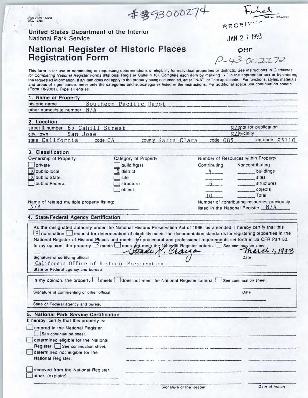
2 SOUTH TERMINAL PHASE II PROJECT FINDING OF EFFECT (No Adverse Effect) Submitted to FEDERAL TRANSIT ADMINISTRATION REGION IX San Francisco Federal Building 90, 7th Street Suite San Francisco, CA AND PENINSULA CORRIDOR JOINT POWERS BOARD 1250 San Carlos Avenue, 3 rd Floor San Carlos, CA PREPARED BY JRP Historical Consulting, LLC 2850 Spafford Street Davis, CA April 7, 2016
3 [page intentionally blank] Finding of No Adverse Effect South Terminal Phase II Project II
4 Contents EXECUTIVE SUMMARY PROJECT DESCRIPTION AFFECTED ENVIRONMENT IDENTIFICATION EFFORTS DESCRIPTION AND DISCUSSION OF SIGNIFICANCE SIGNIFICANT FEATURES OF SOUTHERN PACIFIC DEPOT HISTORIC DISTRICT (DIRIDON STATION) FINDING OF NO ADVERSE EFFECT DEFINING EFFECTS ANALYSIS OF EFFECTS CUMULATIVE EFFECTS IMPACTS ANALYSIS LIST OF PREPARERS Tables Table 1. Previously evaluated properties within the APE Table 2: Summary of Effects on Southern Pacific Depot Historic District Figures Figure 1. Project limits and Key Project Elements Figure 2. Built Environment Area of Potential Effect Appendices A. National Register of Historic Places Nomination Form for the Southern Pacific Depot at Cahill Street, San Jose, California (Diridon Station) Finding of No Adverse Effect South Terminal Phase II Project III
5 Acronyms ACHP ADA CRHR Caltrans FTA JPB km NRHP OHP SHPO Advisory Council on Historic Preservation Americans with Disabilities Act California Register of Historical Resources California Department of Transportation Federal Transit Administration Peninsula Corridor Joint Powers Board kilometers National Register of Historic Places Office of Historic Preservation State Historic Preservation Officer Finding of No Adverse Effect South Terminal Phase II Project IV
6 Executive Summary This report applies the criteria of effect pursuant to 36 CFR Part to historic properties for the Caltrain South Terminal Phase II Project proposed by the Peninsula Corridor Joint Powers Board (JPB) and located in the City of San José, Santa Clara County, California. This report was completed to assist the Federal Transit Administration, Region IX (FTA) and JPB in fulfilling their responsibilities as required by the National Historic Preservation Act (NHPA) of 1966 (as amended) (16 U.S.C., Section 470 (f) and its implementing regulations (36 CFR Part 800). This report also includes impacts analysis for the purposes of compliance with the California Environmental Quality Act (CEQA) as it pertains to historical resources, see Section 4. The South Terminal Phase II Project (project) consists of the construction of a fourth mainline track from the JPB Centralized Equipment Maintenance and Operation Facility (CEMOF) to Diridon Station, as well as construction of a small section of track to install a crossover north of the CEMOF. Also included in the project is construction of new signal controls and associated switches to maintain operational flexibility and minimize delays. The project will require minor right-of-way acquisition from the City of San Jose property occupied by the San Jose SAP Center parking lot, a PG&E corporation yard, and buildings at 60 Stockton Avenue and Stockton Avenue. All changes as a part of the South Terminal Phase II project will be consistent with the Secretary of the Interior s standards for rehabilitation and reuse. All are completely reversible. The only historic property located within the Area of Potential Effect (APE) for this project is the Southern Pacific Depot Historic District (Diridon Station) on Cahill Street. 1 The historic property includes several buildings and structures, as well as the Santa Clara Underpass and railroad tracks, which are within the APE. Southern Pacific originally owned and operated a station, and although this site has served as a railway station since the 19 th century, the current station buildings were constructed between 1932 and Amtrak took over long distance passenger train service in 1971 and was succeeded by Caltrain, which is the current operator of the commuter service. See Section 2 for a summary of the history and significance of Diridon Station. This document applies the Criteria of Effect and Adverse Effect (36 CFR et. seq.) to the historic resources potentially affected by the Caltrain South Terminal Phase II Project, and finds that the proposed project will result in no adverse effect to the Southern Pacific Depot 1 The station has been referred to variously as Cahill Station, Diridon Station, San Jose Diridon Station, and the Southern Pacific Station on Cahill Street. Finding of No Adverse Effect South Terminal Phase II Project 1
7 Historic District because it will not diminish the historic function or character-defining features of the property. Finding of No Adverse Effect South Terminal Phase II Project 2
8 1. Project Description The Peninsula Corridor Joint Powers Board, operator of the Caltrain commuter rail system, proposes the South Terminal Phase II Project (the proposed project) in the City of San Jose, Santa Clara County, California. The proposed project consists of construction of a fourth mainline track and new signal controls between the south end of Caltrain s Centralized Equipment Maintenance and Operation Facility (CEMOF) and the north end of Diridon Station in San Jose. The additional track would be approximately 2,100 feet in length from CEMOF (MP 46.9) to the north end of Diridon Station (MP 47.3), just north of West Santa Clara Street. The proposed project also includes some modifications to the existing track systems, where they need to be realigned to accommodate the fourth track within the right of way (ROW) to the extent practicable and associated signal control work. In addition, the project includes construction of a small segment of track in order to install a cross over north of CEMOF. The design features of the project include a total of 11 crossovers/turnouts/slip-switches. New overhead signal bridges will be constructed in six locations in conjunction with the track and signal upgrades. Two bridges are located within the project limits: West Julian Street at mile post (MP) 47.15; and West Santa Clara Street at MP No modifications to the bridge structures would be required to accommodate the fourth track. The project limits and key project elements are presented in Figure 1. The proposed project would require minor ROW acquisitions of approximately 20,000 square feet, with approximately 2,000 square feet on the north side of the existing tracks west of Julian Street, 3,000 square feet on the south side of the existing tracks west of Julian Street, and the remaining 15,000 square feet along the eastern edge of the project limits. 2 The majority, or about 13,000 square feet of acquisitions would occur on the City of San Jose property occupied by the San Jose SAP Center parking lot (APN: , -44). Approximately 84 parking spaces are found within the ROW acquisition area and would be mitigated in coordination with the City of San Jose, potentially by restriping the SAP Center parking lot to avoid net loss in parking. The remaining acquisitions would consist of narrow strips of land totaling about 3,000 square feet from a PG&E corporation lot west of Julian Street at 308 Stockton Avenue (APN: ), 2,000 square feet from two adjacent UPRR parcels west of Julian Street (APN: , -022), and 2,000 square feet from lots at 60 Stockton Avenue (APN: ) and Stockton Avenue (APN: ). These strip acquisitions do not include removal or alteration of any buildings or structures. 2 Right-of-way and parking space impacts are based on the Caltrain ROW and OCS files from CALMOD received on February 26, FINDING OF NO ADVERSE EFFECT SOUTH TERMINAL PHASE II 3

9 Figure 1: Project Limits. FINDING OF NO ADVERSE EFFECT SOUTH TERMINAL PHASE II 4
10 2. Affected Environment 2.1 Identification Efforts JRP Historical Consulting, LLC (JRP) identified the appropriate built environment Area of Potential Effect (APE) (Figure 2), and historic properties within the APE for the proposed project. The APE includes the railroad right-of-way and legal parcels intersected by the footprint of the project. One historic property has been identified within that APE: the Southern Pacific Depot Historic District (Diridon Station), which includes the San Jose (W. Santa Clara Street) Underpass. The area surrounding the project is a mix of light industrial, residential, and civic development along the former Southern Pacific Railroad line. Many of the light industrial and residential areas have undergone redevelopment resulting in built environment of mixed uses in buildings of various ages and materials. Seven previously evaluated built environment resources are located within the APE (Table 1). These include the buildings at 60 Stockton Avenue and Stockton Avenue; a PG&E corporate yard (645 Lenzen Avenue); the Julian Street Underpass (P ); the Calpak San Jose Plants/Mid-Town Industrial Historic District (P ); and the Southern Pacific Depot (P ) and San Jose Underpass (P ). The Julian Street Underpass, 60 Stockton Avenue, Stockton Avenue, and the PG&E property at 645 Lenzen Avenue are not historic resources/properties based upon previous evaluation. 3 The Southern Pacific Depot and its components constitute the only NRHP-eligible property, defined either as a discrete historic district, or as a component of the formerly eligible Calpak San Jose Plants/Mid-Town Industrial District, a larger property that has lost historic integrity. 3 JRP Historical Consulting, LLC, BART Silicon Valley Phase II Santa Clara Extension Project: Supplemental Built Environment Survey Report, 2014; DPR-523 Form Julian Street Underpass MP (P ), Inventory and Evaluation of Historic Resources, Caltrain Electrification Project, San Francisco to Gilroy (MP0.0 to 77.4), prepared by Theresa Rogers and Chris Mc Morris, JRP Consulting Services, While the Julian Street Underpass is similar in appearance to the San Jose Underpass, its location on a smaller feeder road and the fact that it lacks visual linkage with the Southern Pacific Depot district resulted in its not eligible status. FINDING OF NO ADVERSE EFFECT SOUTH TERMINAL PHASE II 5

11 Figure 2. Area of Potential Effects FINDING OF NO ADVERSE EFFECT SOUTH TERMINAL PHASE II 6
12 Table 2. Previously evaluated properties within the APE Primary Number n/a Property Name PG&E garage within corporation yard at 645 Lenzen Avenue. Year Built California Historic Resources Code Notes 1954c. 6Z Evaluated 2014 for BART Silicon Valley Phase II Santa Clara Extension Project; environmental document in preparation, not yet submitted to Information Center. PG&E offices on the parcel are less than 50 years old and not exceptionally significant. n/a Stockton Avenue Z Evaluated 2014 for BART Silicon Valley Phase II Santa Clara Extension Project; environmental document in preparation, not yet submitted to Information Center. n/a 60 Stockton Avenue 1920c. 6Z Evaluated 2014 for BART Silicon Valley Phase II Santa Clara Extension Project; environmental document in preparation, not yet submitted to Information Center. P Julian Street Underpass (Caltrans Bridge 37C-207) Not eligible for listing in the NRHP or CRHR P P P Calpak San Jose Plants/ Mid-Town Industrial District Southern Pacific Depot (Diridon Station) Historic District San Jose Underpass (Caltrans Bridge 37-05) at W. Santa Clara Street and The Alameda 3D Evaluators disagreed upon identification of district; most properties within district now demolished or altered. Only component within the APE is Southern Pacific Depot (see below) S Listed on the NRHP in 1993 (# ), includes underpass S Contributing element of the Southern Pacific Depot Historic District. The Calpak San Jose Plants/Mid-Town Industrial Historic District appeared eligible when it was evaluated in 1998; however, subsequent redevelopment and construction in the area has greatly diminished the number of potentially contributing elements. The Mid-Town Industrial portion of the district was first identified in 1997 by Laffey and Duval as NRHPeligible, with a proposed area bounded by Sunol and Wilson to the west, The Alameda to the north, Cahill to the east, and a line south of the buildings facing San Fernando Street to the south. Subsequent studies did not agree with this conclusion. The area was again evaluated and identified as a three-site, Calpak San Jose Plants discontiguous district in FINDING OF NO ADVERSE EFFECT SOUTH TERMINAL PHASE II 7
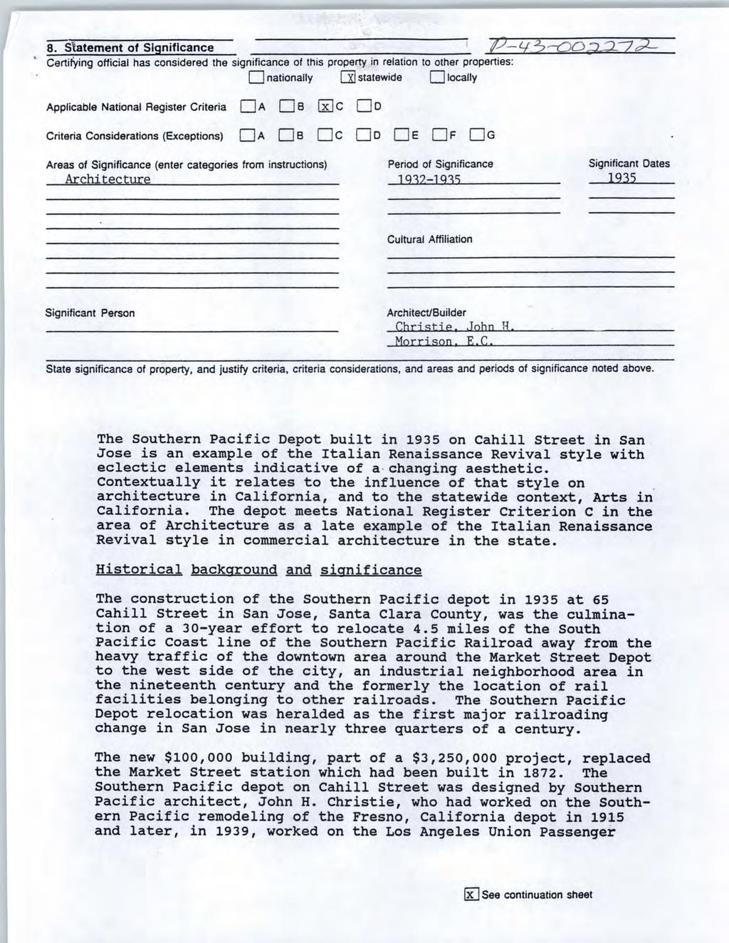
13 1998. Two of these sites are located within the area covered by the Information Center search for this project, but are largely outside the built environment APE: the previously identified Mid-Town Industrial district, and a former Calpak plant north of Auzerais Avenue between Sunol Street and Los Gatos Creek. 4 The third site is located over a mile to the north east near 7 th Street and Empire Street. 5 The Mid-Town Industrial district overlaps the southwestern edge of the APE. Of the nine contributors originally identified for this potential district, only three remain: the Calpak District Manager s Office at 734 The Alameda, Plant #51 (redeveloped as condominiums), and the Southern Pacific Depot (Diridon Station) Historic District. Of the three contributors to the district, only the Southern Pacific Depot Historic District is located within the APE. The Southern Pacific Depot Historic District (Diridon Station) is listed in the NRHP and is also component of the previously identified Calpak San Jose Plants/ Mid-Town Industrial Historic District. The Southern Pacific Depot nomination includes several vernacular sheds, a water tower, butterfly passenger shelters, and the nearby San Jose Underpass that carries W. Santa Clara Street under the railroad tracks. The water tower has been removed, but otherwise the depot property components remain largely intact, except for the tracks. Previous evaluation of the rail lines themselves indicates that the tracks have been altered, removed, and replaced over time and now lack integrity and are not eligible for listing in the NRHP or CRHR as contributing elements. The only contributor that could be potentially affected by this project is the W. Santa Clara Street Underpass. 2.2 Description and Discussion of Significance Architectural Historian Elizabeth A. McKee of Caltrans nominated the Southern Pacific Depot on Cahill Street in San Jose to the National Register of Historic Places in April Her evaluation stated that the station complex was eligible under Criterion C, for its architectural values, with a period of significance of based on the dates of construction. The historic district included four buildings, and six structures. The buildings include the depot, car cleaner s shack, herder s shack, and compressor house. The structures included the water tower, Santa Clara Underpass, the tracks at the station, two butterfly passenger sheds, and surrounding wall and fence system. Since time of the nomination the water tower, compressor house, and herder s shack have been removed, and the tracks extensively modified. 4 The other site considered by the earlier district evaluation is well to the south of the project area, outside the APE on Auzerais Avenue, and has been redeveloped leaving only portions of the original plant walls and the water tower. This site was reevaluated after its redevelopment. The remnant walls were found to lack historical significance, but the water tower remains a local Structure of Merit. 5 This site has also been redeveloped. Finding of No Adverse Effect South Terminal Phase II Project 8
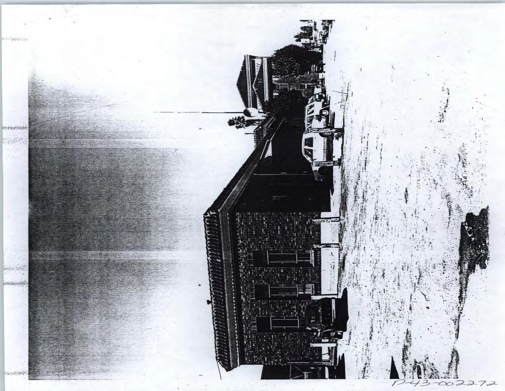
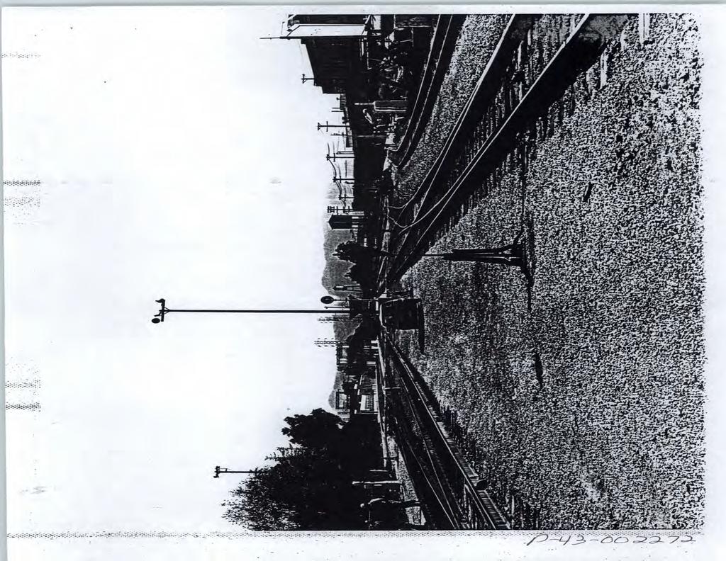
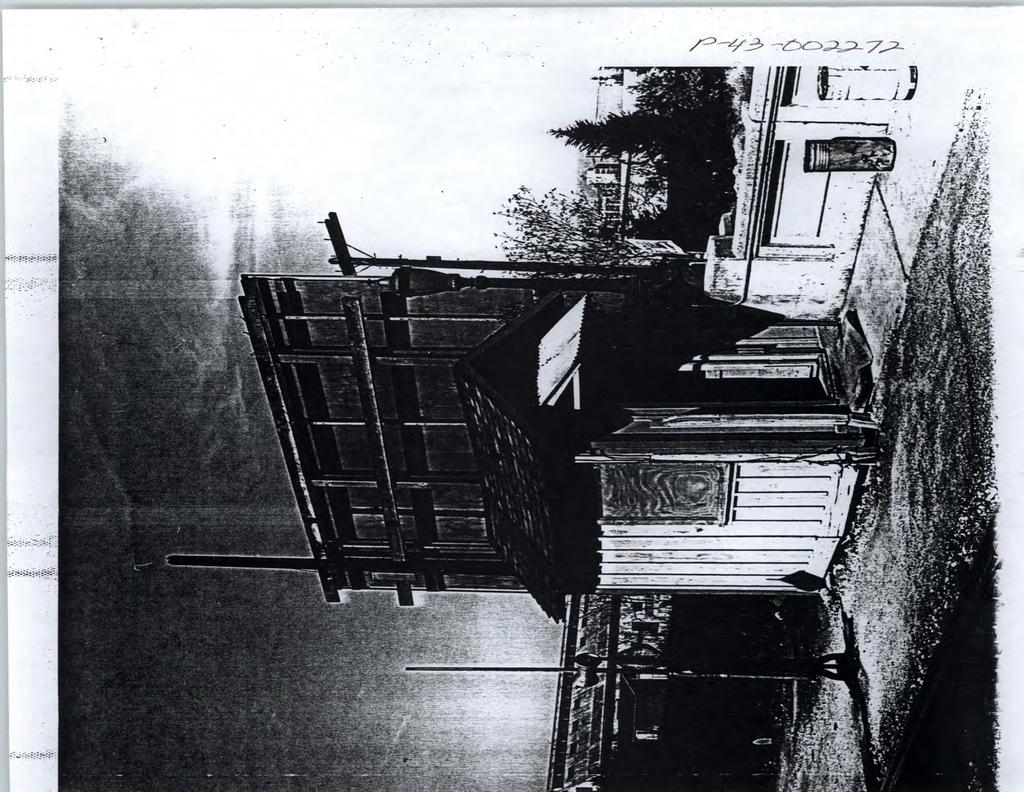
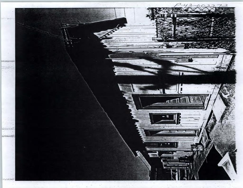
14 The Italian Renaissance Revival depot building, with brick walls and terra cotta roof, was designed by John C. Christie and built by E.C. Morrison, and replaced a much older station on Market Street in San Jose. Ms. McKee described the depot as follows: The Southern Pacific Depot on Cahill Street in San Jose is a multi-level combination (passenger and freight) railroad depot constructed in the Italian Renaissance Revival style. Built in 1935, it consists of a three-story central section flanked by two-story wings. The building, a compilation of rectangular sections, is 390 feet long and varies in width from 40 feet to 78 feet. The central section, which contains the passenger waiting room, measures 40 by 80 feet and 33 feet in height. The high center pavilion housing the waiting room is constructed of steel columns and trusses. The side wings are framed with wood. The roofs of the three main sections are hipped with medium boxed eaves and covered with terra cotta tile in varied shades of red and sunset. The south and rear wings are flat roofed and only trimmed with terra cotta tile. The exterior walls are clad with tapestry brick of varied colors and arranged in an English bonding pattern. The foundation walls are concrete. The depot is located in an industrial area dominated by warehouses and related commercial businesses. The depot faces east onto Cahill Street, which is lined with trees. Several vernacular sheds, a water tower, butterfly passenger sheds and the nearly Alameda Underpass are all contributing structures within the railroad station, which serves as the setting for the depot. The property is in fair condition and has been altered very little since its construction. 6 Passenger platforms west of the depot are sheltered under butterfly sheds. The simple shelters with inverted gable, V-shaped roofs were manufactured by the Soule Steel Company. The car cleaner s shack to the south of the depot is a vernacular wood framed shed with gable roof. This simple building is clad in board-and-batten siding and includes numerous doors along the façade for the interior rooms. The public areas of the depot are separated from operational areas by an iron fence, a key feature of which is the gate with Classical posts and curvilinear ironwork at the north side of the depot. Contributing tracks once included the four passenger tracks serving the original platforms, a freight track, and tracks sufficient to direct traffic without impacting passenger service. The existence of tracks along the west side of the depot and along the platforms is still a character-defining feature of the depot district because they link the depot to its historic use; however, the design and materials of the tracks were modified both before and after the NRHP nomination and the individual tracks do not retain integrity to the period of significance ( ) and are not contributing elements of the property. The water tower, compressor house, and herder s shack have been removed and are no longer contributing elements of the district. 6 National Register Nomination form for San Jose Southern Pacific Railroad Station, San Jose. Prepared by Elizabeth A. McKee, April Finding of No Adverse Effect South Terminal Phase II Project 9
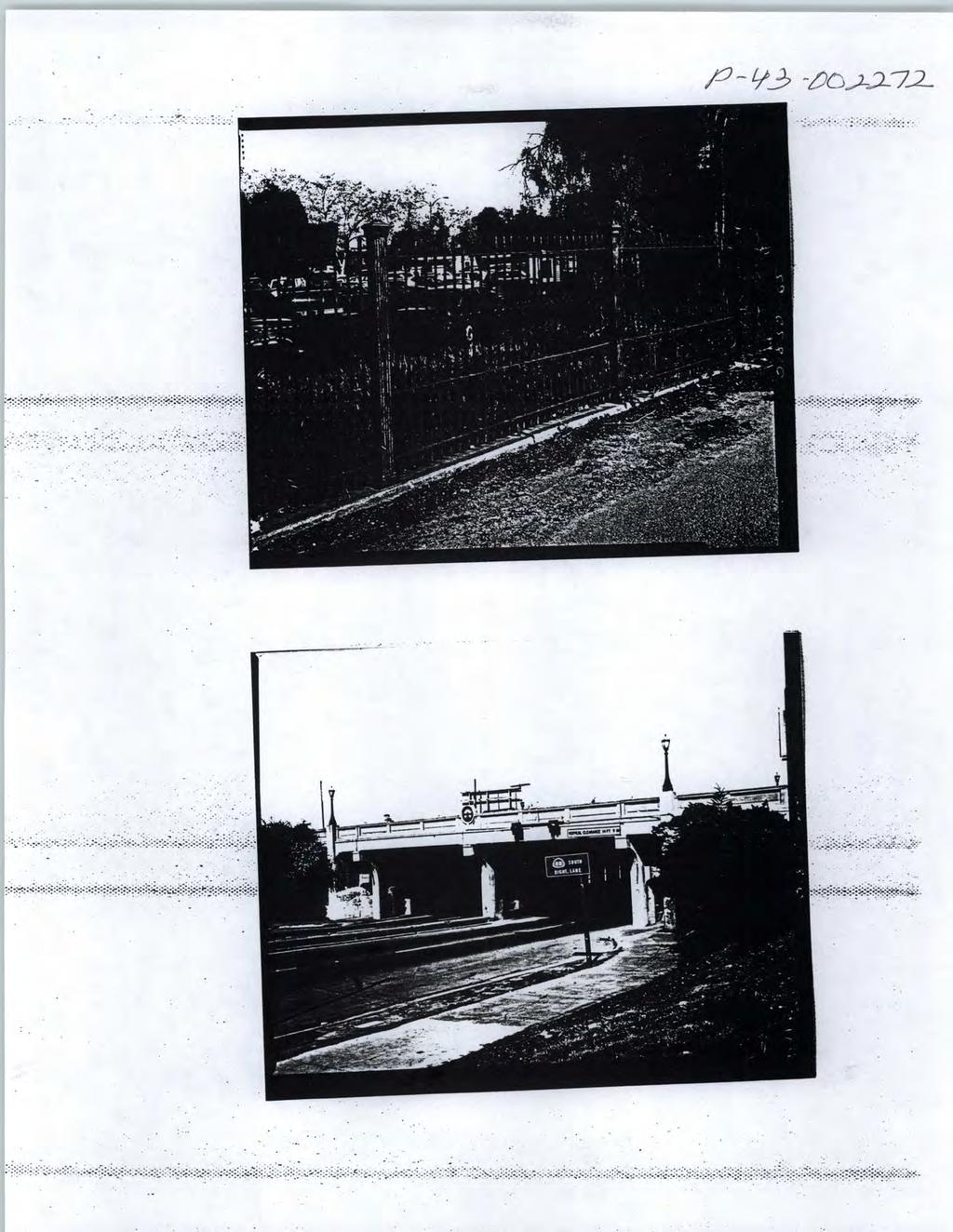
15 The W. Santa Clara Street Underpass (also known as the San Jose Underpass, Caltrans Bridge No 37-45) is located at the northern end of the historic depot district. The underpass is a steel girder bridge 82 feet long with a central concrete pier. The abutments accommodate pedestrian passages adjacent to, but separated from the roadway by a wall pierced with windows. The bridge carries the railroad over W. Santa Clara Street, which is depressed below the rail lines carried on the bridge. The upper railings of the bridge are solid and include an enameled Southern Pacific emblem above the central pier. The railing is further adorned with Beaux-Arts lamp posts at the end posts cast by Sunnyvale s Joshua Hendy Iron Works. A copy of the nomination form is attached to this report in Appendix A. The Cahill Depot (station building) was also designated as a landmark, by the City of San Jose on January 24, Since the time of this nomination the setting of the depot district has been affected to a degree by the construction of the San Jose SAP Center directly across The Alameda to the north, and redevelopment and construction projects in the general neighborhood, including removal of part of the industrial complex to the west and rehabilitation of the remaining Calpak Plant #51 building into condominiums. These changes in setting do not appear to have diminished the overall historic integrity of the district. 7 City of San Jose Landmarks are properties of special historical, architectural, cultural, aesthetic, or engineering interest or value of a historic nature (City of San Jose). Finding of No Adverse Effect South Terminal Phase II Project 10
16 2.3 Significant Features of Southern Pacific Depot Historic District (Diridon Station) As noted above, the following features were specified as significant in the NRHP nomination and in the historic preservation covenant for the Depot historic district. Exterior: All historic features located on the parcels being transferred by Caltrans to the Peninsula Corridor Joint Powers Board including: Station building: o brick masonry and mortar; o roof; o windows and doors and their frames, sashes, and glass; o terra cotta cornice and decorative elements; wrought iron fencing; subway and ramps from station to platforms; entrance marquis; flag pole, paint color of gate, grille, and fence; historic trees butterfly passenger sheds Also included in the nomination were the car cleaner s shed, the W. Santa Clara Street Underpass, herders shed and tracks. Only approximately 60% of the entire station yard (essentially the northern end) was included (see the district boundaries depicted in the nomination form, included in Appendix A). The covenant focused upon the depot and immediately adjoining features, but drawing corollaries between the materials mentioned and the structure of the Santa Clara underpass provides an understanding of the character defining features of the underpass. Characteristic materials are the reinforced concrete and the steel girders which form the structural elements. The defining design elements are the concrete formed openings, windows, and voids for the automotive and pedestrian lanes. The concrete decorative items such as the railing, luminaries, and Southern Pacific emblem upon the bridge complete the character defining features of the underpass. Of the listed resources, only the track alignment will be directly affected by project activities. All other extant features, including the station building, are located outside the area of direct impact, but have been included in the APE to account for potential indirect effects. Finding of No Adverse Effect South Terminal Phase II Project 11
17 3. Finding of No Adverse Effect This Finding of No Adverse Effect applies the criteria of adverse effect (36 CFR 800.5) and follows the guidelines for documentation in 36 CFR The finding assesses effects of the project for the Southern Pacific Depot Historic District, which is an historic property listed in the NRHP. 3.1 Defining Effects The definition of effect is that contained within 36 CFR Part 800: Effect means alteration to the characteristics of a historic property qualifying it for inclusion in or eligibility for the National Register. An adverse effect occurs when an undertaking may alter, directly or indirectly, any of the characteristics of a historic property that qualify the property for inclusion in the National Register in a manner that would diminish the integrity of the property s location, design, setting, materials, workmanship, feeling, or association. (36 CFR 800.5(a)) An effect is noted in this document only when it poses the potential to alter the characteristics of the historic property that qualify it for inclusion in the NRHP. The language of 36 CFR Part also states: (1) Criteria of adverse effect. Consideration shall be given to all qualifying characteristics of a historic property, including those that may have been identified subsequent to the original evaluation of the property's eligibility for the National Register. Adverse effects may include reasonably foreseeable effects caused by the undertaking that may occur later in time, be farther removed in distance or be cumulative. (2) Examples of adverse effects. Adverse effects on historic properties include, but are not limited to: (i) Physical destruction of or damage to all or part of the property; (ii) Alteration of a property, including restoration, rehabilitation, repair, maintenance, stabilization, hazardous material remediation, and provision of handicapped access, that is not consistent with the Secretary's standards for the treatment of historic properties (36 CFR part 68) and applicable guidelines; (iii) Removal of the property from its historic location; (iv) Change of the character of the property's use or of physical features within the property's setting that contributes to its historic significance; (v) Introduction of visual, atmospheric or audible elements that diminish the integrity of the property's significant historic features; Finding of No Adverse Effect South Terminal Phase II Project 12
18 (vi) Neglect of a property which causes its deterioration, except where such neglect and deterioration are recognized qualities of a property of religious and cultural significance to an Indian tribe or Native Hawaiian organization; and (vii) Transfer, lease, or sale of property out of Federal ownership or control without adequate and legally enforceable restrictions or conditions to ensure long-term preservation of the property's historic significance. Of these, only (ii) alteration of a property, including restoration, rehabilitation, repair, maintenance, stabilization, hazardous material remediation, and provision of handicapped access, that is not consistent with the Secretary's standards for the treatment of historic properties (36 CFR part 68) and applicable guidelines, applies to this project. 3.2 Analysis of Effects The Southern Pacific Depot Historic District is composed of six extant related resources, including the main terminal building, the butterfly passenger sheds, car cleaners shed, the Santa Clara Underpass (grade separation), fencing and walls, and passenger platforms. The station complex is an active facility, serving Amtrak, Caltrain, and Union Pacific Railroad freight trains. The proposed track addition is located north of the station potentially affecting the existing (non-historic) tracks. Section 1.1 describes the proposed project, which involves the construction of a fourth track entering the station district and consequent realignment of tracks at the northern end of the historic district to accommodate the new tracks and necessary switches. A signal bridge will be constructed across the tracks just north of the station, outside the district boundaries, but visible from the station. While the track alterations begin on the W. Santa Clara Street Underpass, the realignment on the deck will not affect the underpass itself. Additional realignments will accommodate switches necessary to retain operational patterns. All realignments occur north of the station passenger platforms. The track alterations and signal bridge will not affect the structure, design, or decorative character defining features of the underpass. The tracks were noted as a character-defining feature of the Southern Pacific Depot Historic District in its nomination without further description. The tracks had already been subject to minor realignment prior to the nomination, and comparison of aerial photography indicates that the area north of the station and crossing the W. Santa Clara Street Underpass were among the areas subject to previous track realignment. The realignments proposed by the current project will not alter the use of the rail yard area, which will continue to be used both by freight and passenger trains. The proposed project will only involve the northern quarter of the tracks and maintain the historic functions of passenger transport for the Finding of No Adverse Effect South Terminal Phase II Project 13
19 depot, and freight tracks which bypass the station. The replacement of track will not affect the materials and workmanship as the materials have already been replaced. The existing tracks will retain their general layout west of the station and association with the station and passenger and freight service. The tracks will also retain the feeling of an active rail line with multiple parallel tracks separating and merging before and after the station. Realigned track will be replaced in kind, which is consistent with the Secretary of the Interior s Standards for Rehabilitation. Overall, the historic character of the property will be retained. The alignment and materials of existing tracks within the Southern Pacific Depot Historic District will be directly impacted. The existing tracks are no longer contributing elements of the district, but their general function (multiple lines serving the passenger platforms) is a character-defining feature of the property because they link the components of the Southern Pacific Depot Historic District to their continuing historic use. The specific locations and materials of the tracks were altered before and after the listing of the district in the NRHP, and have continued to be altered during subsequent projects at the station. Therefore the addition of a rail line will not diminish the tracks as character-defining features of the district because both the new and existing tracks will continue to serve the function of this transportation facility. The addition of the fourth track is also consistent with the Secretary of the Interior s Standards for the Treatment of Historic Properties, specifically Rehabilitation. The project, therefore, will not have a direct or indirect adverse effect on the tracks as a character-defining feature of the Southern Pacific Depot Historic District. Construction of a signal bridge just north of the historic district will introduce an element visible from the district. This element will not interfere with the relationships of any of the district contributors, or introduce new visual, atmospheric, or audible elements to the district. The construction of the signal bridge will not have any direct effects upon any of the district s contributors or character defining features. Although the signal bridge will be a new structure in the district setting, the Southern Pacific Depot Historic District was built and exists in an area of mixed industrial and residential use along a historic rail transportation corridor. The proposed signal bridge is rail transportation infrastructure that is in keeping with the historic setting and historic function of the district and will not diminish the district s integrity. Consequently, the construction of the signal bridge will not have a direct or indirect adverse effect upon the Southern Pacific Depot Historic District. Finding of No Adverse Effect South Terminal Phase II Project 14
20 Table 2: Summary of Effects on Southern Pacific Depot Historic District Aspects of Historic Integrity Location Design Setting Materials Workmanship Feeling Association Project Effects Not Adverse Not Adverse Not Adverse Not Adverse Not Adverse Not Adverse Not Adverse 3.3 Cumulative Effects The Southern Pacific Depot Historic District has been subject to multiple previous findings of effect analyses. The first was dated April 1992 and covered the transfer of Caltrain stations from Caltrans to JPB operation. It included a preservation covenant for the station, which listed the following as significant features for the Southern Pacific Depot on Cahill Street in San Jose: Exterior: All historic features located on the parcels being transferred by Caltrans to the Peninsula Corridor Joint Powers Board including brick masonry and mortar; roof; windows and doors and their frames, sashes, and glass; terra cotta cornice and decorative elements; wrought iron fencing; subway and ramps from station to platforms; entrance marquis; flag pole, paint color of gate, grille, and fence; historic trees. While several contributing elements including the butterfly passenger sheds, car cleaners shed, grade separation, and herders shed were not mentioned specifically, it is reasonable to include them as part of all historic [exterior] features located on the parcels 8 Projects that have not had adverse effects on the historic district include modifications to comply with the Americans with Disabilities Act (ADA), and improvements to signage and passenger services. The second effects analysis was prepared in February 1996 and addressed minor actions to modify the station to comply with the ADA. A third report addressed the adverse effects of construction of the Vasona Light Rail line station to the west of the station building, which, as a part of its construction, required moving the station s water tower (a contributing element of the National Register property) and connecting the light rail station to the historic station by joining a new tunnel with the 8 Preservation Covenant, San Jose Station (Cahill). Appendix 2, Description of Significant Features. Finding of No Adverse Effect South Terminal Phase II Project 15
21 exiting platform tunnel from the station. In 2001, another finding of effect addressed the proposed construction of poles and catenaries that extend through the butterfly passenger sheds on the Caltrain platforms, concluding that the project had no adverse effect. In 2002, additional changes to the station required under the ADA were evaluated as having no adverse effect. A finding of no adverse effect prepared in 2006 addressed the transformation of former freight areas into offices and additional required changes to other public and nonpublic interior spaces pursuant to the ADA. And the following year, another finding of no adverse effect was prepared for the construction of two new passenger platforms west of the existing platforms. Adverse effects have occurred due to the removal of small contributing buildings and structures. This began with the removal of the water tower in 2000 as part of the construction of the Vasona Light Rail Station along the west side of the historic district. The herder s shack and compressor house were subsequently been removed to facilitate operations. Because the proposed project will not have an adverse effect, and is consistent with the Secretary of the Interior s Standards for Treatment of Historic Properties, none of the alterations will cause direct or indirect adverse effects. The proposed project will not make substantial irreversible changes to the contributing elements of the historic property. The proposed addition of a fourth track will not diminish or impair the existing non-historic tracks and will allow the tracks serving the station to remain a generally character-defining feature of the depot district. No other alteration to contributing elements or character-defining features is contemplated. The proposed project, when considered with the effects of previous projects, would not result in a cumulative adverse effect. Finding of No Adverse Effect South Terminal Phase II Project 16
22 4. Impacts Analysis The California Environmental Quality Act (CEQA) requires that California public agencies identify the significant environmental impacts of their actions and either avoid those impacts, or mitigate those impacts. This impacts analysis was prepared to assist state and local agencies, as well as the general public, to understand the potentially significant impacts that may be caused by the project, and if such impacts are identified, how those impacts may be avoided and/or minimized. The impacts findings for the Southern Pacific Depot Historic District follow this description of substantial adverse change and the guidelines for determining significant impacts to historical resources for the purposes of CEQA. The California Code of Regulations, beginning with (b), defines significant impacts for historical resources as follows: (1) Substantial adverse change in the significance of an historical resource means physical demolition, destruction, relocation, or alteration of the resource or its immediate surroundings such that the significance of an historical resource would be materially impaired. (2) The significance of an historical resource is materially impaired when a project: (A) Demolishes or materially alters in an adverse manner those physical characteristics of an historical resource that convey its historical significance and that justify its inclusion in, or eligibility for, inclusion in the California Register of Historical Resources; or (B) Demolishes or materially alters in an adverse manner those physical characteristics that account for its inclusion in a local register of historical resources pursuant to section (k) of the Public Resources Code or its identification in an historical resources survey meeting the requirements of section (g) of the Public Resources Code, unless the public agency reviewing the effects of the project establishes by a preponderance of evidence that the resource is not historically or culturally significant; or (C) Demolishes or materially alters in an adverse manner those physical characteristics of a historical resource that convey its historical significance and that justify its eligibility for inclusion in the California Register of Historical Resources as determined by a lead agency for purposes of CEQA. (3) Generally, a project that follows the Secretary of the Interior's Standards for the Treatment of Historic Properties with Guidelines for Preserving, Rehabilitating, Finding of No Adverse Effect South Terminal Phase II Project 17
23 Restoring, and Reconstructing Historic Buildings or the Secretary of the Interior's Standards for Rehabilitation and Guidelines for Rehabilitating Historic Buildings (1995), Weeks and Grimmer, shall be considered as mitigated to a level of less than a significant impact on the historical resource. (4) A lead agency shall identify potentially feasible measures to mitigate significant adverse changes in the significance of an historical resource. The lead agency shall ensure that any adopted measures to mitigate or avoid significant adverse changes are fully enforceable through permit conditions, agreements, or other measures. This impacts analysis concludes that there is no substantial adverse change anticipated for the Southern Pacific Depot Historic District. This district includes six extant contributors as described in Section 2.2 above. These contributors are the depot, W. Santa Clara Street Underpass, two butterfly sheds, walls and fences, passenger platforms, and the car cleaner s shack. The Santa Clara Underpass is the only contributor potentially impacted by project activities. While the general function of the existing tracks are character-defining features of the district, the individual rail lines have been altered over time and are no longer contributing elements. The proposed South Terminal Phase II project will not entail any changes or alterations to the Santa Clara Underpass, and will not cause adverse changes to the tracks as character-defining features. The construction of the signal bridge north of the district will not directly impact any of the contributors to the district or introduce new incompatible features to the district. The South Terminal Phase II project involves the construction of a fourth mainline from the JPB CEMOF south to Diridon Station within the Southern Pacific Depot Historic District. The construction of this line will involve the realignment of existing tracks from the Santa Clara Underpass to the northern edge of the passenger platforms to accommodate the incoming track and necessary switches that insure continued flexibility in the operations. This flexibility in operations, which historically allowed mail, baggage, express, and freight traffic to be managed through the station without disrupting passenger traffic, along with the ability to link the other components of the district to their historic use is a general, character-defining feature of the district. Continued use of the existing tracks and the additional line is consistent with historic passenger and freight operations and maintains the ability of the district to convey its historic significance. Consequently, there is no substantial adverse change to the historic property and no significant impact from the South Terminal Phase II project. Construction of the signal bridge north of the district does not materially alter any contributor or characteristic that accounts for its inclusion in the California Register of Historical Resources. The signal bridge will be located outside the district and supports the continued use of the district for rail related activities. Finding of No Adverse Effect South Terminal Phase II Project 18
24 List of Preparers This Finding of (no adverse) Effect was prepared under the direction of Meta Bunse, partner, JRP Historical Consulting, LLC. Ms. Bunse has more than 25 years of experience as a historian and architectural historian in Cultural Resources Management following her Masters of Arts degree in public history from California State University, Sacramento. Her experience includes numerous historical resource surveys and compliance documents for Section 106 of NHPA and CEQA. Cheryl Brookshear, Architectural Historian, JRPR Historical Consulting, LLC, with more than 9 years of experience working in Cultural Resources Management prepared the text of this report. Ms. Brookshear has a Master of Science degree in historic preservation from the University of Pennsylvania and qualifies as a historian/architectural historian under United States Secretary of Interior s Professional Standards (as defined in 36 CFR Part 61). Finding of No Adverse Effect South Terminal Phase II Project 19
25 Appendix A: National Register of Historic Places Nomination Form for the Southern Pacific Depot at Cahill Street, San Jose, California (Diridon Station) Finding of No Adverse Effect South Terminal Phase II Project 20
26

27
28

29

30

31
32
33

34

35

36

37
38
39
40

41

42

43

44

45

46

47
48
49
50
51

52
53

54

55

56

57
58

59

60

61

62

63

64

65

66
2.1.8 Cultural Resources Regulatory Setting. Affected Environment, Environmental
 REVISED DRAFT ENVIRONMENTAL IMPACT REPORT/ Affected Environment, Environmental 2.1.8 Cultural Resources This section evaluates the potential for historical and archaeological resources within the proposed
CHAPTER 4.0: REVISIONS TO THE DRAFT SEIR
 CHAPTER 4.0: REVISIONS TO THE DRAFT SEIR This chapter contains the revisions to the Draft SEIR. Text that has been deleted from the draft document is shown with a red line through the deleted text. Text
CEQA and Historic Preservation: A 360 Degree Review
 CEQA and Historic Preservation: A 360 Degree Review California Preservation Foundation Workshop February 11, 2015 Presented by Chris McMorris Partner / Architectural Historian CEQA and Historic Preservation
SECTION 106 DETERMINATION OF EFFECTS REPORT
 SECTION 106 DETERMINATION OF EFFECTS REPORT Prepared for: Southeastern Pennsylvania Transportation Authority (SEPTA) Prepared by: AECOM January 2017 Determination of Effects Report King of Prussia Rail,
APPENDIX J SHPO COORDINATION
 Final Environmental Impact Statement/Final Environment Impact Report Appendix J SHPO Coordination APPENDIX J SHPO COORDINATION August 2011 CRENSHAW/LAX TRANSIT CORRIDOR PROJECT Final Environmental Impact
Visual and Aesthetic Resources
 Visual and Aesthetic Resources 7.1 INTRODUCTION This chapter evaluates the effects of the Modified Design on visual and aesthetic resources, in comparison to the effects of 2004 FEIS Design. The 2004 FEIS
M E M O R A N D U M PLANNING AND COMMUNITY DEVELOPMENT DEPARTMENT CITY OF SANTA MONICA PLANNING DIVISION
 M E M O R A N D U M 10-B PLANNING AND COMMUNITY DEVELOPMENT DEPARTMENT CITY OF SANTA MONICA PLANNING DIVISION DATE: April 9, 2018 TO: FROM: SUBJECT: The Honorable Landmarks Commission Planning Staff 133
APPENDIX D: Visual and Aesthetic Conditions for NCCU Station Refinement. Durham-Orange Light Rail Transit Project
 APPENDIX D: Visual and Aesthetic Conditions for NCCU Station Refinement Durham-Orange Light Rail Transit Project October 2016 1. Introduction The Combined FEIS/ROD summarizes the effects of the D-O LRT
Meeting Display Boards for Public Hearing on the Wilson Transfer Station Project held Tuesday, February 18, 2014.
 Meeting Display Boards for Public Hearing on the Wilson Transfer Station Project held Tuesday, February 18, 2014. Board 1: Welcome Welcome to the Wilson Transfer Station Project Public Hearing. The purpose
2.1 Decision Making Matrix
 2.1 Decision Making Matrix The following decision-making matrix merges the elements of architectural and historical significance and current condition within the over-arching treatment recommendation of
7.0 SECTION 4(F) EVALUATION
 EVALUATION") Chapter 7 Section 4(f) Evaluation 7.0 SECTION 4(F) EVALUATION 7.1 Background Information and Regulatory Requirements This chapter presents the existing conditions and potential effects to parklands and
Chapter 7 Section 4(f) Evaluation 7.0 SECTION 4(F) EVALUATION 7.1 Background Information and Regulatory Requirements This chapter presents the existing conditions and potential effects to parklands and
Project Description. Dear Ms. Roland-Nawi:
 U.S. Department of Transportation Federal Transit Administration REGION IX Arizona, California, Hawaii, Nevada, Guam American Samoa, Northern Mariana Islands 201 Mission Street Suite 1650 San Francisco,
CEQA and Historic Resources: The Local Government Perspective
 CEQA and Historic Resources: The Local Government Perspective Ken Bernstein, Principal City Planner City of Los Angeles, Office of Historic Resources The Three Key Questions on CEQA and Historic Resources
Appendix E Section 4(f) Evaluation
 Evaluation") Appendix E Section 4(f) Evaluation Appendix E Draft Section 4(f) Evaluation E.1 Introduction This appendix addresses a federal regulation known as Section 4(f), which protects parks, recreation areas,
Appendix E Section 4(f) Evaluation Appendix E Draft Section 4(f) Evaluation E.1 Introduction This appendix addresses a federal regulation known as Section 4(f), which protects parks, recreation areas,
Draft Environmental Assessment Appendix A. SHPO Correspondence, January 19, 2017
 Draft Environmental Assessment Appendix A. SHPO Correspondence, January 19, 2017 Rosecrans/Marquardt Grade Separation Project April 2018 Federal Railroad Administration U.S. Department 1200 New Jersey
Appendix E Memorandum of Agreement between FHWA and the SHPO
 Appendix E between FHWA and the SHPO MEMORANDUM OF AGREEMENT BETWEEN THE FEDERAL HIGHWAY ADMINISTRATION AND THE FLORIDA STATE HISTORIC PRESERVATION OFFICER PURSUANT TO 36 CFR PART 800 REGARDING THE WEKIVA
Standards Compliance Review 303 Baldwin Avenue, San Mateo, California
 303 Baldwin Avenue, San Mateo, California Prepared for City of San Mateo Prepared by 6 April 2018 SAN FRANCISCO Pier 9, The Embarcadero, Suite 107, San Francisco, California 94111 T: 415.421.1680 F: 415.421.0127
Addendum to Environmental Impact Report
 Addendum Date: January 2, 2014 Case No.: 2007.0603E Project Title: Compliance Hospital Replacement Program EIR: 2007.0603E, certified June 19, 2008 Project Sponsors: Diane Kay, UCSF Campus Planning (415)
Stewardship. Streamlining. Consensus
 Stewardship Streamlining Consensus Translating Section 106: Building Consensus among Multiple Responsible Parties For the Doyle Drive Replacement Project in the Presidio of San Francisco National Historic
MINNESOTA ARCHITECTURE - HISTORY INVENTORY FORM
 Identification Historic Name Dean Parkway Bridge Current Name Bridge 90661 Field # Address Midtown Greenway over Dean Parkway City/Twp Minneapolis County Hennepin Legal Desc. Twp 29N Range 24W Sec 32 QQ
Page. I. Introduction 1. II. Project Purpose and Need 2. IV. Description of Section 4(f) Property 2. V. Impacts to Section 4(f) property 3
 Property 2. V. Impacts to Section 4(f) property 3") Table of Contents Programmatic Section 4(f) Evaluation for use of a Historic Bridge Replacement of Route 30/130 Bridge over the Cooper River Structure No. 0405-153 City of Camden, Borough of Collingswood,
Table of Contents Programmatic Section 4(f) Evaluation for use of a Historic Bridge Replacement of Route 30/130 Bridge over the Cooper River Structure No. 0405-153 City of Camden, Borough of Collingswood,
City Center Specific Plan Amendments And Background Report City of Richmond. PLANNING COMMISION FINAL DRAFT January, 2001
 City Center Specific Plan Amendments And Background Report City of Richmond PLANNING COMMISION FINAL DRAFT January, 2001 TABLE OF CONTENTS Page LIST OF TABLES... LIST OF FIGURES... INDEX... OVERVIEW...
SBCAG STAFF REPORT. MEETING DATE: March 17, 2016 AGENDA ITEM: 5I
 SBCAG STAFF REPORT SUBJECT: Cabrillo-UPRR Bridge Project MEETING DATE: March 17, 2016 AGENDA ITEM: 5I STAFF CONTACT: Fred Luna RECOMMENDATION: Authorize the chair to sign a Memorandum of Understanding
Northern Branch Corridor SDEIS March Table of Contents
 Table of Contents Executive Summary... ES-1 ES.1 Introduction... ES-1 ES.2 Project Background... ES-1 ES.3 Purpose and Need... ES-5 ES.4 Alternatives... ES-6 ES.5 Operating Plan... ES-11 ES.6 Cost Analysis...
Overall Map. Chicago. St. Louis. Summit. Joliet. Dwight. Pontiac. Bloomington-Normal Lincoln. Springfield. Carlinville. Alton EXPERIENCE IT YOURSELF.
 Overall Map Summit Chicago Bloomington-Normal Lincoln New Station Planned New Station Planned Dwight Pontiac Joliet Pedestrian overpass and second platform planned Higher speed service began in this section
HISTORIC RESOURCES INVENTORY AND EVALUATION REPORT
 HISTORIC RESOURCES INVENTORY AND EVALUATION REPORT Los Gatos Creek Bridge Replacement/ South Terminal Phase III Project San Jose, Santa Clara County, California Prepared for Peninsula Corridor Joint Powers
4.13 Security and System Safety
 4.13 4.13.1 Introduction This section describes the affected environment and environmental consequences related to security and system safety from operations of the NEPA Alternatives. Information regarding
Mississippi Skyway Preliminary Engineering Report
 EXECUTIVE SUMMARY Mississippi Skyway Preliminary Engineering Report CITY OF RAMSEY, MINNESOTA DECEMBER 2014 City of RAMSEY EXECUTIVE SUMMARY Project Need and Intent The Mississippi Skyway pedestrian bridge
Fourth Street Spenger s
 L A N D M A R K S P R E S E R V A T I O N C O M M I S S I O N S t a f f R e p o r t FOR COMMISSION ACTION OCTOBER 2, 2014 1901 1919 Fourth Street Spenger s Structural Alteration Permit Application (LMSAP2014-0006)
June 7, Mr. Brian. 150 North. Third Streett. Foote. On behalf. Master Plan Project. Disney Studios. I. Final EXHIBIT Q-1
 June 7, 2016 Submitted by email Mr. Brian Foote City of Burbank Community Development Department 150 North Third Streett Burbank, CA 91502 Email: bfoote@burbankca.gov Re: Draft Supplemental Environmental
Right-of-Way Acquisitions and Relocations Technical Memorandum
 Right-of-Way Acquisitions and Relocations Technical Memorandum Southeast Extension Project Lincoln Station to RidgeGate Parkway Prepared for: Federal Transit Administration Prepared by: Denver Regional
MIDTOWN MIXED-USE VILLAGE. TECHNICAL DATA SHEET COMPONENT C-1 FOR PUBLIC HEARING - PETITION NUMBER Project No RZ1.1. Issued.
 N MIDTOWN MIXED-USE VILLAGE TECHNICAL DATA SHEET COMPONENT C- FOR PUBLIC HEARING - PETITION NUMBER 04-00 Project No. 496 Issued Revised SCALE: " = 0' N 0 0 0 40 RZ. c GENERAL PROVISIONS: a. SITE LOCATION.
APPENDIX G. Shadow Memo
 APPENDIX G Shadow Memo BSMC Summit Campus Seismic Upgrade and G-1 ESA / 207376 Master Plan Project Draft EIR December 2009 THIS PAGE INTENTIONALLY LEFT BLANK G-2 225 Bush Street Suite 1700 San Francisco,
HIGH-SPEED RAIL PROGRAM UPDATE. Gilroy Unified School District & Gilroy City Council September 24, 2018 Gilroy City Council Chambers, Gilroy, CA
 HIGH-SPEED RAIL PROGRAM UPDATE Gilroy Unified School District & Gilroy City Council September 24, 2018 Gilroy City Council Chambers, Gilroy, CA OVERVIEW Introductions High-Speed Rail Project Update Overview
3.5 VISUAL AND AESTHETIC QUALITIES
 3.5 VISUAL AND AESTHETIC QUALITIES 3.5.1 Introduction to Analysis 3.5.1.1 Summary of Results The Preferred Alternative would represent a minimal change to the visual character of the existing rail corridor.
7.5 Impacts on the Section 4(f) Properties
 Properties") constructive use, such as noise, air quality and visual impacts were also assessed. It was determined that this project would not introduce changes of an external nature that would affect the recreational
constructive use, such as noise, air quality and visual impacts were also assessed. It was determined that this project would not introduce changes of an external nature that would affect the recreational
CHAPTER 2: HISTORIC BACKGROUND
 CHAPTER 2: HISTORIC BACKGROUND The historic town of Eastlake was created on June 22, 1911 when the Eastlake Subdivision was recorded at the Adams County Clerk and Recorder s Office. The Eastlake Investment
Kankakee River Bridge & Track Improvements Supplemental Environmental Assessment. May 5, 2016
 Kankakee River Bridge & Track Improvements Supplemental Environmental Assessment May 5, 2016 1 History: Chicago-St. Louis Corridor Since 1980 s IDOT has been looking at this corridor for high-speed service
4.5 Cultural Resources
 4.5 4.5.1 Introduction This section describes the environmental consequences related to cultural resources from operations of the NEPA Alternatives. The analysis in this section is based on the following
The Role of Cities in Planning Transportation Megaprojects
 The Role of Cities in Planning Transportation Megaprojects SPUR Oakland, November 28, 2018 + Elizabeth Deakin / UC Berkeley + Eric Eidlin / City of San Jose + Doug Johnson / City of San Francisco The Role
1.0 Circulation Element
 5/9/18 1.0 Circulation Element 1.1 Introduction As growth and development occur in Apache County, enhancements to its circulation system will be necessary. With time, more roads will be paved and air and
THE PLANNING AREA 2.1 PLANNING AREA LOCATION
 2. The Planning Area Brisbane Baylands Specific Plan 21 2 THE PLANNING AREA 2.1 PLANNING AREA LOCATION The Baylands is located approximately midway between San Francisco s central business district and
Station Area Plan Introduction & Draft Alternatives Review
 Station Area Plan Introduction & Draft Alternatives Review City Council Meeting - February 22, 2016 Project Background: California High-Speed Rail San Jose to San Fernando Valley Segment CHSRA will select
5.0 Historic Resource Survey
 5.0 Historic Resource Survey SECTION 5.1 INTRODUCTION The Historic Resources Survey is a document which identifies all Contributing and Non-contributing structures and all contributing landscaping, natural
Clay Street Bridge Replacement Project
 Clay Street Bridge Replacement Project Frequently Asked Questions (FAQs) No. 2 April 4, 2018 The project is located in downtown Placerville on Clay Street between US Highway 50 and Main Street and Cedar
Glenborough at Easton Land Use Master Plan
 Implementation 114 9.0 IMPLEMENTATION 9.1 OVERVIEW This chapter summarizes the administrative procedures necessary to implement the proposed land use plan, infrastructure improvements, development standards,
Planning Commission Staff Report March 15, 2007
 Planning Commission Staff Report Project: Request: Madeira East Tentative Subdivision Map, Design Review for Subdivision Layout & Abandonment of Easements Location: Phase IV of the Laguna Ridge Specific
4.11 Land Use Introduction Environmental and Regulatory Setting Environmental Setting
 4.11 4.11.1 Introduction This section describes the affected environment and environmental consequences related to land use from operations of the NEPA Alternatives. Information regarding land use and
East Corridor Final Environmental Impact Statement
 East Corridor Final Environmental Impact Statement Alternatives Considered Operating Plan The requirements for opening day operations versus year 2030 are based on ridership and operations. Opening day
FINAL MITIGATION PLAN to address
 CENTRAL CORRIDOR LRT STATE CAPITOL MALL HISTORIC FINAL MITIGATION PLAN February 2010 FINAL MITIGATION PLAN to address Adverse Effects of the Central Corridor LRT Project on the State Capitol Mall Historic
EXHIBIT A. Tax Increment Reinvestment Zone No. 1 (Town Center) First Amended Project Plan 1
 First Amended Project Plan 1") EXHIBIT A Tax Increment Reinvestment Zone No. 1 (Town Center) First Amended Project Plan 1 1 As amended by Resolution No. 2008-02-001(TR1R) of the Tax Increment Reinvestment Zone No.1, and approved to
EXHIBIT A Tax Increment Reinvestment Zone No. 1 (Town Center) First Amended Project Plan 1 1 As amended by Resolution No. 2008-02-001(TR1R) of the Tax Increment Reinvestment Zone No.1, and approved to
ORDINANCE NO Adopted by the Sacramento City Council. November 10, 2016
 ORDINANCE NO. 2016-0048 Adopted by the Sacramento City Council November 10, 2016 LISTING THE SACRAMENTO RAILYARDS WATER TOWER AS A LANDMARK ON THE SACRAMENTO REGISTER OF HISTORIC & CULTURAL RESOURCES BACKGROUND
M i s s i o n B a y W a t e r f r o n t
 114 M i s s i o n B a y W a t e r f r o n t Character of the Area: The Mission Bay Waterfront extends from Pier 48 at China Basin Channel to 18th Street in the Central Basin. This area of the waterfront
Analysis of Environs of 1000 New York Street, German Methodist Episcopal Church
 Item No. 3: L-14-00028 p.1 Analysis of Environs of New York Street, German Methodist Episcopal Church Step One Historical Significance and Context According to the application for Historic Landmark Designation,
Chapter 2, Section C: Urban Design and Visual Resources A. INTRODUCTION
 Chapter 2, Section C: Urban Design and Visual Resources A. INTRODUCTION This attachment considers the potential of the proposed East River Waterfront Access Project at Peck Slip to effect urban design
The impacts examined herein take into account two attributes of aesthetic values:
 IV. ENVIRONMENTAL IMPACT ANALYSIS This section addresses the potential impacts to views and aesthetics as a result of the proposed Project at the Project Site and the development scenarios analyzed for
COLVER ROAD INDUSTRIAL CONCEPT PLAN
 COLVER ROAD INDUSTRIAL CONCEPT PLAN A CONCEPTUAL LAND USE AND TRANSPORTATION PLAN FOR TA-4 AN URBAN RESERVE AREA OF THE CITY TALENT City of Talent Adopted by City Council Resolution No., June, 2015 PART
Appendix E Preliminary Location Hydraulic Study
 Appendix E Prepared for: State of Alaska Department of Transportation and Public Facilities Prepared by: HDR Alaska, Inc. 2525 C Street, Suite 305 Anchorage, Alaska 99503 February 2014 This page intentionally
No comments related to land use and planning issues were received in response to the Notice of Preparation.
 4.8 LAND USE AND PLANNING This section analyzes the impacts relative to land use and planning that would occur as a result of implementation of the proposed Facilities Master Plan (proposed project). This
MINNESOTA ARCHITECTURE - HISTORY INVENTORY FORM
 Identification Historic Name Nicollet Avenue Bridge Current Name Nicollet Avenue Bridge Field # Address Nicollet Avenue over Minnehaha Creek City/Twp Minneapolis SHPO Inventory Number Review and Compliance
TRANSPORTATION ELEMENT GOALS, OBJECTIVES, AND POLICIES
 TRANSPORTATION ELEMENT GOALS, OBJECTIVES, AND POLICIES GOAL 2 The City shall provide a safe, convenient, effective, and energy efficient multimodal transportation system which is coordinated with the Future
Bridge Type Assessment and Evaluation
 16M-01410-01 (3216026) Glen Road Pedestrian Bridge EA Study Bridge Type Assessment and Evaluation Factor Group/Criteria Alternative 1: Steel girder with two inclined steel legs Alternative 2: Steel girder
Dumbarton Rail Corridor. Project Scoping Meeting Nov 15, :15 PM City of Newark Nov 16, :15 PM City of Menlo Park
 Dumbarton Rail Corridor Project Scoping Meeting Nov 15, 2006 7:15 PM City of Newark Nov 16, 2006 7:15 PM City of Menlo Park 1 Presentation Overview I. Introduction History of the Project II. III. Purpose
LOS ANGELES CITY PLANNING DEPARTMENT STAFF REPORT
 LOS ANGELES CITY PLANNING DEPARTMENT STAFF REPORT LOS ANGELES CITY PLANNING COMMISSION CASE NO: CPC 2006-9374 CRA CEQA: Exempt DATE: December 21, 2006 Location: Valley Plaza and Laurel Plaza TIME: after
1755 Le Roy Avenue (Tellefson Hall)
") L A N D M A R K S P R E S E R V A T I O N C O M M I S S I O N S t a f f R e p o r t FOR COMMISSION ACTION FEBRUARY 3, 2011 1755 Le Roy Avenue (Tellefson Hall) Structural Alteration Permit Application (LM
L A N D M A R K S P R E S E R V A T I O N C O M M I S S I O N S t a f f R e p o r t FOR COMMISSION ACTION FEBRUARY 3, 2011 1755 Le Roy Avenue (Tellefson Hall) Structural Alteration Permit Application (LM
Architectural Inventory Form
 OAHP1403 Rev. 9/98 COLORADO CULTURAL RESOURCE SURVEY Architectural Inventory Form Official eligibility determination (OAHP use only) Date Initials Determined Eligible- NR Determined Not Eligible- NR Determined
Metro Orange Line Extension Four Years Early and $61 Million Under Budget
 White Paper: Metro Orange Line Extension Four Years Early and $61 Million Under Budget July 2013 Innovation for better mobility Metro Orange Line Extension Iteris, Inc. was the prime consultant leading
Visual and Aesthetics
 Such a connection could accommodate timed transfers and improve connections between local transit service and Presidio Shuttle service. Level of Service The results of the analysis are provided on a route-by-route
Section 4(f) Chapter Introduction. 8.2 Regulatory Setting
 Chapter Introduction. 8.2 Regulatory Setting") Chapter 8 8.1 Introduction This chapter describes the environmental and regulatory setting for resources and summarizes the evaluation of the BART Extension Alternative relative to the Department of Transportation
Chapter 8 8.1 Introduction This chapter describes the environmental and regulatory setting for resources and summarizes the evaluation of the BART Extension Alternative relative to the Department of Transportation
TOWN OF WHITBY REPORT RECOMMENDATION REPORT
 TOWN OF WHITBY REPORT RECOMMENDATION REPORT REPORT TO: Council REPORT NO: PL 95-09 DATE OF MEETING: October 13, 2009 PREPARED BY: Planning/Public Works Joint Report FILE NO(S): N/A LOCATION: N/A REPORT
RESOLUTION NO. R Refining the route, profile and stations for the Downtown Redmond Link Extension
 RESOLUTION NO. R2018-32 Refining the route, profile and stations for the Downtown Redmond Link Extension MEETING: DATE: TYPE OF ACTION: STAFF CONTACT: Capital Committee Board PROPOSED ACTION 09/13/2018
3.4 ARCHAEOLOGICAL, HISTORIC, AND PALEONTOLOGICAL RESOURCES
 3. AFFECTED ENVIRONMENT AND ENVIRONMENTAL CONSEQUENCES Final Environmental Impact Statement and Section 4(f) Evaluation 3.4 ARCHAEOLOGICAL, HISTORIC, AND PALEONTOLOGICAL RESOURCES 3.4.1 Archaeological
The transportation system in a community is an
 7 TRANSPORTATION The transportation system in a community is an important factor contributing to the quality of life of the residents. Without a sound transportation system to bring both goods and patrons
Appendix G Response to Comments
 Appendix G Response to Comments This appendix contains the comments received during the public circulation and comment period (May 27, 2008 to July 11, 2008). The comments have been numbered (Comment Set
Architectural Inventory Form
 COLORADO CULTURAL RESOURCE SURVEY Page 1 of 8 Official Eligibility Determination (OAHP use only) Rev. 9/98 OAHP1403 Date Initials Determined Eligible National Register Determined Not Eligible National
(blank page) WestConnex New M Roads and Maritime Services Environmental impact statement
 WestConnex New M Roads and Maritime Services Environmental impact statement") (blank page) WestConnex New M5 5-42 (blank page) WestConnex New M5 5-44 5.5 Tunnels 5.5.1 Main alignment tunnels The main alignment tunnels would be about nine kilometres long, with the western tunnel
(blank page) WestConnex New M5 5-42 (blank page) WestConnex New M5 5-44 5.5 Tunnels 5.5.1 Main alignment tunnels The main alignment tunnels would be about nine kilometres long, with the western tunnel
ARROYO PROJECTS ADOPTED CAPITAL IMPROVEMENT PROGRAM BUDGET
 A RROYO P ROJECTS ADOPTED CAPITAL IMPROVEMENT PROGRAM BUDGET FISCAL YEARS 214-218 HAHAMONGNA Priority Description 1 Hahamongna Watershed Park - Implement Master Plan 211,6 211,6 (77565) 2 Hahamongna -
Chapter 8: BEACH SOUTH OF ATLANTIC AVENUE NEIGHBORHOOD PLANNING AREA ANALYSIS
 Chapter 8: BEACH SOUTH OF ATLANTIC AVENUE NEIGHBORHOOD PLANNING AREA ANALYSIS The Beach South of Atlantic Avenue Neighborhood Planning Area includes the parcels adjacent to S Fletcher Avenue from Atlantic
Urban Design Brief Woodland Cemetery Funeral Home 493 Springbank Drive
 Urban Design Brief Woodland Cemetery Funeral Home The Incorporated Synod of the Diocese of Huron April 15, 2016 Urban Design Brief April 15, 2016 TABLE OF CONTENTS Page No. INTRODUCTION... 1 SECTION 1
MEMORANDUM. DATE: March 15, Chairman and Members Community Redevelopment Agency. Leif J. Ahnell, C.P.A., C.G.F.O. Executive Director
 MEMORANDUM DATE: March 15, 2019 TO: FROM: Chairman and Members Community Redevelopment Agency Leif J. Ahnell, C.P.A., C.G.F.O. Executive Director SUBJECT: Camino Square, IDA No. CRP-16-02, located at 171
Section 3.16 Visual Quality
 Chapter 3 Affected Environment, Environmental Consequences, and Mitigation Measures Section 3.16 Visual Quality Introduction This section discusses existing conditions, effects and mitigation measures
8 October 14, 2015 Public Hearing
 8 October 14, 2015 Public Hearing APPLICANT & PROPERTY OWNER: PRICE S HOLDINGS, LLC STAFF PLANNER: Karen Lasley REQUEST: A. Conditional Use Permit (Automobile Repair Garage) B. Change in Nonconforming
CULTURAL HERITAGE RESOURCES POLICIES
 New Official Plan CULTURAL HERITAGE RESOURCES POLICIES Date March 6, 2009 Distributed at: Livable Oakville Committee, March 9, 2009 Planning Services Department March 2009 1 1 Policy Discussion Paper:
4.500 Preston Road Overlay District
 Section 4.500 Preston Road Overlay District 2004 Zoning Ordinance 4.500 Preston Road Overlay District (ZC 98-29; Ordinance No. 98-9-12) 4.501 Purpose To provide appropriate design standards for the use
Notice of Preparation (NOP) of an Environmental Impact Report and Public Scoping Meeting for the Alameda Shipways Residential Project
 of an Environmental Impact Report and Public Scoping Meeting for the Alameda Shipways Residential Project") Notice of Preparation (NOP) of an Environmental Impact Report and Public Scoping Meeting for the Notice is hereby given that the City of Alameda, Lead Agency, will prepare an Environmental Impact Report
Notice of Preparation (NOP) of an Environmental Impact Report and Public Scoping Meeting for the Notice is hereby given that the City of Alameda, Lead Agency, will prepare an Environmental Impact Report
Transportation Improvements
 Transportation Improvements 0 0 Volume II of the Final EIS for the DHS Headquarters consolidation at St. Elizabeths includes analysis to transportation improvements for the DHS Headquarters Consolidation
3.10 LAND USE SETTING PROJECT SITE EXISTING LAND USE DESIGNATIONS AND ZONING. General Plan Land Use Designations.
 This section of the Draft EIR addresses the existing land uses on and adjacent to the project site and discusses the potential impacts of the proposed project on existing land uses. Key issues addressed
7.0 DRAFT SECTION 4(f) EVALUATION
 EVALUATION") 7. DRAFT SECTION 4(f) EVALUATION 7.1 Background Information and Regulatory Requirements This chapter presents the existing conditions and potential effects on parks, recreation areas, wildlife and waterfowl
7. DRAFT SECTION 4(f) EVALUATION 7.1 Background Information and Regulatory Requirements This chapter presents the existing conditions and potential effects on parks, recreation areas, wildlife and waterfowl
4.16 Visual Quality and Aesthetics
 4.16 4.16.1 Introduction This section describes the affected environment and environmental consequences related to visual quality and aesthetics from operations of the NEPA Alternatives. Information regarding
Los Angeles Department of City Planning RECOMMENDATION REPORT
 Los Angeles Department of City Planning RECOMMENDATION REPORT CULTURAL HERITAGE COMMISSION HEARING DATE: April 7, 2011 TIME: 10:00 AM PLACE: City Hall, Room 1010 200 N. Spring Street Los Angeles, CA 90012
BEST PRACTICES FOR PROJECT NOMINATIONS TA Set-Aside Program
 BEST PRACTICES FOR PROJECT NOMINATIONS 2017 TA Set-Aside Program Focus of this presentation Photos Public Support Maps & Exhibits Proposed Budget Design Details Project Evaluation & Selection Criteria
5.4.6 Cumulative Operational Impacts
 5.4.5.2 Visual Character Impacts The proposed project is located in greater downtown Los Angeles, which is a dynamic environment where new projects are constructed on an ongoing basis. Additional development
Chapter Master Planned Communities (MPC) District
 District") Sections 14.53.010 Purpose and Intent 14.53.020 Applicability 14.53.030 Procedure 14.53.040 MPC Standards 14.53.050 Required Findings 14.53.010 Purpose and Intent Chapter 14.53 Master Planned Communities
Sections 14.53.010 Purpose and Intent 14.53.020 Applicability 14.53.030 Procedure 14.53.040 MPC Standards 14.53.050 Required Findings 14.53.010 Purpose and Intent Chapter 14.53 Master Planned Communities
PLANNING JUSTIFICATION REPORT
 PLANNING JUSTIFICATION REPORT 55 DELHI STREET CITY OF GUELPH PREPARED FOR: VESTERRA PROPERTY MANAGEMENT PREPARED BY: LABRECHE PATTERSON & ASSOCIATES INC. SCOTT PATTERSON, BA, CPT, MCIP, RPP PRINCIPAL,
Project Study Report Equivalent The Old Road Widening SIX FLAGS MAGIC MOUNTAIN. On Street The Old Road Between Magic Mountain Pkwy And Turnberry Lane
 Project Study Report Equivalent The Old Road Widening SIX FLAGS MAGIC MOUNTAIN On Street The Old Road Between Magic Mountain Pkwy And Turnberry Lane On Street Henry Mayo Drive Between The Old Road And
M E M O R A N D U M CITY PLANNING DIVISION PLANNING AND COMMUNITY DEVELOPMENT DEPARTMENT CITY OF SANTA MONICA
 M E M O R A N D U M CITY PLANNING DIVISION PLANNING AND COMMUNITY DEVELOPMENT DEPARTMENT CITY OF SANTA MONICA DATE: March 13, 2017 TO: FROM: The Honorable Landmarks Commission Planning Staff SUBJECT: Certificate
Memo. B R A Y H e r i t a g e
 6 1 3. 5 4 2. 3 3 9 3 6 1 3. 5 4 9. 6 2 3 1 c a r l @ b r a y h e r i t a g e. c o m Memo To: Jennifer Murray, Windmill Development Corporation From: Carl Bray, Bray Heritage Date: Monday, June 5, 2017
I539. Smales 2 Precinct
 I539. Smales 2 Precinct I539.1. Precinct Description The Smales 2 Precinct applies to a 4.8 hectare block of land located on the southern side of Northcote Road and fronting Lake Pupuke, Takapuna. The
ENVIRONMENTAL REQUIREMENTS FOR FEDERALLY FUNDED PROJECTS: SECTION 106 AND SECTION 4(F)
") ENVIRONMENTAL REQUIREMENTS FOR FEDERALLY FUNDED PROJECTS: SECTION 106 AND SECTION 4(F) Oklahoma Association of County Engineers November 8, 2016 Law and Regulatory Requirements: Section 106 National Historic
ENVIRONMENTAL REQUIREMENTS FOR FEDERALLY FUNDED PROJECTS: SECTION 106 AND SECTION 4(F) Oklahoma Association of County Engineers November 8, 2016 Law and Regulatory Requirements: Section 106 National Historic
Transportation Committee
 Transportation Committee Business Item No. 2013-286SW Meeting date: October 14, 2013 For the Metropolitan Council meeting of October 16, 2013 Subject: Southwest Light Rail Transit (Green Line Extension):