4.16 Visual Quality and Aesthetics
|
|
|
- Dwight Collins
- 5 years ago
- Views:
Transcription
1 Introduction This section describes the affected environment and environmental consequences related to visual quality and aesthetics from operations of the NEPA Alternatives. Information regarding visual quality and aesthetics in the City of San Jose and the City of Santa Clara was obtained from: Envision San Jose 2040 General Plan (City of San Jose 2011a). Envision San Jose 2040 General Plan EIR (City of San Jose 2011b). City of Santa Clara General Plan (City of Santa Clara 2010a). City of Santa Clara General Plan EIR (City of Santa Clara 2010b) Environmental and Regulatory Setting Environmental Setting The BART Extension would be generally located in an urbanized portion of central San Jose and the southeast portion of Santa Clara, approximately 45 miles southeast of San Francisco and within the Santa Clara Valley. The Santa Clara Valley is bounded on the west by the Santa Cruz Mountains and on the east by the Diablo Range and runs south southeast from the southern end of the San Francisco Bay. Visual quality, prominent features, and scenic resources within San Jose and Santa Clara are described below. Visual Study Area The visual study area for the BART Extension is the area visible from the alignment and from which the BART Extension features can be seen. The visual study area includes the alignment, which is relatively flat and extends approximately 6 miles from just east of U.S. Highway 101 (U.S. 101) and south of Mabury Road in San Jose to approximately the Santa Clara Caltrain Station. The visual study area also includes the available offsite views from within the alignment. Given that the majority of the BART Extension is underground and thus would not be visible, this analysis focuses on aboveground features. Viewer groups within the visual study area consist of existing residents; workers at office or industrial sites; and pedestrians, bicyclists, and drivers using roadways in the vicinity of the aboveground features, namely station areas, parking structures, ventilation facilities, systems facility sites, and at-grade portions of the alignment. City of San Jose The visual study area for San Jose extends from Mabury Road to just north of Interstate (I-) 880. The surrounding land uses adjacent to the alignment from Mabury Road to Santa Clara
2 Street are characterized primarily by industrial uses, composed of large, boxed-shaped industrial buildings painted in neutral colors and associated surface parking lots. The alignment along Santa Clara Street from U.S. 101 to South 7 th Street transitions to a mixture of low-rise industrial and commercial buildings, with intermittent single-family and multiple-unit housing on small lots. Santa Clara Street is lined with various types of mature trees with intermittent large, commercial billboards. West of South 7 th Street, mid-rise commercial buildings and high-rise contemporary-style office buildings in the downtown San Jose area dominate the visual character. There are a few open-space areas along the alignment, including Roosevelt Park adjacent to Coyote Creek and the Guadalupe River Park and Gardens recreational area near the Diridon Station South and North Options. Panoramic views of hillside areas, including the foothills of the Diablo Range, Silver Creek Hills, Santa Teresa Hills, and Santa Cruz Mountains, are key scenic features in the San Jose area. Intermittent views of the eastern foothills are available from Mabury Road and North 28 th Street between Julian Street and Santa Clara Street, and there are also views of the Santa Cruz Mountains from Santa Clara Street at Cahill Street. There are no scenic byways or highways within the San Jose visual study area. Overall, the views are typical of an urban area, and no memorable views of natural features exist, with the exception of the distant hillsides. In the vicinity of the Alum Rock/28 th Street Station, the Five Wounds National Portuguese Church and School (Five Wounds Church), which is an ornate, sixteenth-century style church built in 1919, is located on Santa Clara Street west of U.S. 101 immediately adjacent to the Alum Rock/28 th Street Station, and is considered a landmark and architectural resource by the San Jose general plan within the San Jose visual study area. The primary viewer groups would be workers in nearby industrial and commercial buildings; visitors of the Five Wounds Church; residents in the Roosevelt Park neighborhood west of 28 th Street between Julian Street and Santa Clara Street; and motorists, pedestrians, and cyclists in the area, particularly those traveling along Santa Clara Street and 28 th Street. Views primarily consist of industrial buildings and the visually prominent Five Wounds Church near 28 th and Santa Clara Streets. The eastern foothills are located approximately 4 miles northeast of the study area and can be seen intermittently from 28 th Street looking east. In the vicinity of the 13 th Street Ventilation Structure, there are primarily one- and two-story neutral colored commercial buildings and street trees, with distant views of large-scale buildings associated with downtown San Jose. Single-family residential homes are located north of the ventilation structure on either side of 13 th Street within the Julian/St. James and Horace Mann neighborhoods. In the vicinity of the Downtown Station options, the San Jose Downtown Historic District is located along Santa Clara Street between 4 th Street and 1 st Street and also contains several historic buildings listed in the City s Historic Resources Inventory (refer to Section 4.5, Cultural Resources, for details related to historic buildings in the area). These are located immediately adjacent to components of the BART Extension Alternative such as new station
3 portals, and are considered visual resources within the San Jose study area for the Downtown Station options. One- to two-story commercial uses transition to large-scale institutional and office buildings with tree-lined streets traveling west along Santa Clara Street toward downtown San Jose. The historic Diridon Station is located immediately adjacent to the existing Diridon Station on Cahill Street. Near the existing Diridon Station, views are dominated by the visually prominent SAP Center, paved parking areas, transportation amenities, and light industrial uses. Intermittent views of the distant Santa Cruz Mountains are available from Santa Clara Street at Cahill Street looking south. The Santa Cruz Mountains are located over 8 miles south of the study area. One-story neutral colored industrial uses are located on the Stockton Avenue Ventilation Structure site. Intermittent street trees line Stockton Avenue, and several overhead power lines are visible. Across Stockton Avenue to the west is the Garden Alameda neighborhood, which consists of mostly one- and two-story single-family residences. City of Santa Clara The City of Santa Clara visual study area extends from north of I-880 to the existing Santa Clara Caltrain Station and north of Benton Street. The study area is characterized primarily by industrial and commercial uses along the alignment. New single-family multi-story residences are located on the west side of the study area north of I-880, and have neutral coloring with 10- to 14-foot-high walls separating the residences from the existing Caltrain tracks. The industrial areas are dominated by large, neutral-colored buildings with parking lots surrounding the buildings containing sparse landscaping. The built-up, industrial landscape continues on the east side of the alignment. Small commercial, single-story strip malls, institutional buildings such as the Santa Clara Police Department, and the historic Santa Clara Caltrain Station are located near the northern terminus of the study area on the west side of the existing Caltrain tracks that traverse Santa Clara east to west in this location. Santa Clara University is located less than 0.25 mile southwest of the Santa Clara Caltrain Station across El Camino Real. Several trees are along the perimeter of the Santa Clara Caltrain Station and line the El Camino Real corridor. Elements of the historic Santa Clara Caltrain Station/Station Depot (historic Depot) are visual resources, which is located less than 0.10 mile west of the proposed Santa Clara Station platform. The primary viewer groups are workers in nearby industrial and commercial buildings and passengers at the Santa Clara Caltrain Station; visitors and staff of the Santa Clara Police Department; and motorists, pedestrians, and cyclists in the area. Additional viewers include residents in the surrounding neighborhoods, north of Campbell Avenue and west of Newhall Street, and southwest of El Camino Real between De La Cruz Boulevard and Franklin Street. Views primarily consist of a mix of industrial uses, multi-story homes, strip mall style commercial complexes, and the existing Santa Clara Caltrain Station. Intermittent views of the eastern foothills are available from El Camino Real and within the existing Santa Clara
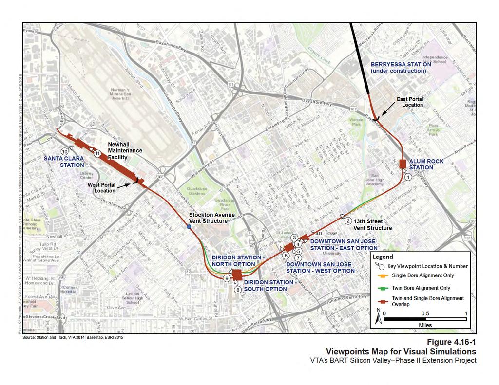
4 Caltrain Station; however, there are no high quality views of any scenic vistas or mountain ranges within the study area Regulatory Setting There are no federal laws that specifically define or protect visual resources; however, state and local regulations provide protection for scenic views and other visual resources. Most local jurisdictions have provisions for design review of all commercial, industrial, or public buildings, facilities, or other major infrastructure. Refer to Chapter 6, Section 6.14, Visual Quality and Aesthetics, for a description of relevant state and local regulations Methodology Pursuant to the National Environmental Policy Act (NEPA), impacts were assessed through evaluation of the degree to which the BART Extension would change the existing visual quality of the study area and consideration of viewer sensitivity. Analysis of visual effects under NEPA considers context for both the existing visual quality category of a viewed landscape (high, moderately high, moderate, moderately low, or low) and the viewer sensitivity (high, moderate, or low). An adverse effect on visual quality and aesthetics would involve a negative change of two or more visual categories (e.g., from high to moderate) where viewer groups of high or moderate sensitivity would see it. The method used to evaluate visual effects is based upon accepted visual analysis techniques, such as those employed by the Federal Highway Administration (FHWA) (1988). The FHWA approach provides both a framework and methodology for assessing the potential impacts associated with highway projects. These methods have been adapted to address the BART Extension and include systematic inventory of existing visual conditions, documentation of visual change, and evaluation of viewer response to change. The evaluation of visual change considers several factors: The extent of visibility and the degree to which the various BART Extension elements would contrast with or be integrated into the existing urban landscape. The extent of change in the affected view s composition and character. The relative number and sensitivity of viewers. Areas possessing sensitive viewer groups or offering scenic views were identified for the purpose of evaluating the visual effects of the BART Extension, and 10 important viewpoint locations were selected within the vicinity. Visual simulations were prepared using computer-generated information overlaid on the photo images of the selected viewpoints to show height and massing of the structural elements that would be seen from each viewpoint. Architectural features were included to make the features appear realistic; however, the simulations are not intended to represent the final design or architectural expression of the
5 BART Extension. Their purpose is to depict the general mass of key station elements as they relate to the surrounding areas. Architecture for the stations would be developed with the City partners and with community input and would be defined in subsequent design phases. Figure shows the locations of 10 viewpoint locations Environmental Consequences and Mitigation Measures This section identifies impacts within the visual study area and evaluates whether they would be adverse according to NEPA No Build Alternative The No Build Alternative consists of the existing transit and roadway networks and planned and programmed improvements along the alignment (see Chapter 2, Section 2.2.1, NEPA No Build Alternative, for a list of these features). The No Build Alternative would likely result in visual effects typically associated with transit, highway, bicycle, and pedestrian, facilities, and roadway projects. These projects are not anticipated to adversely affect the visual character or scenic views in the area. Projects planned under the No Build Alternative would, however, undergo separate environmental review to determine whether the projects would result in adverse visual effects. Review would include an analysis of impacts and identification of mitigation measures to mitigate potential project impacts BART Extension Alternative City of San Jose Visual Study Area Connection to Phase I Berryessa Extension The BART Extension would reconfigure the tail tracks south of Mabury Road in San Jose. Aboveground features in this area include a small portion of the tracks before they descend into a tunnel portal just north of Las Plumas Avenue, and an aboveground structure at the tunnel portal. Currently this area is occupied by an open, flat dirt lot and old railroad tracks. East of the site, land uses are predominantly industrial between Mabury Road and Coyote Creek. West and north of the site is mostly industrial, and the U.S. 101 corridor travels along the southwest side of the alignment. The visual character in this area is defined by one- and two-story, neutral-toned industrial buildings, as well as vehicles traveling along U.S Single-family residential neighborhoods and street trees are located farther southeast beyond the immediate industrial landscape. Given that the majority of the surrounding visual landscape is dominated by industrial and transportation uses, the visual quality of this area is low. There are no high quality scenic views or vistas within this area
6
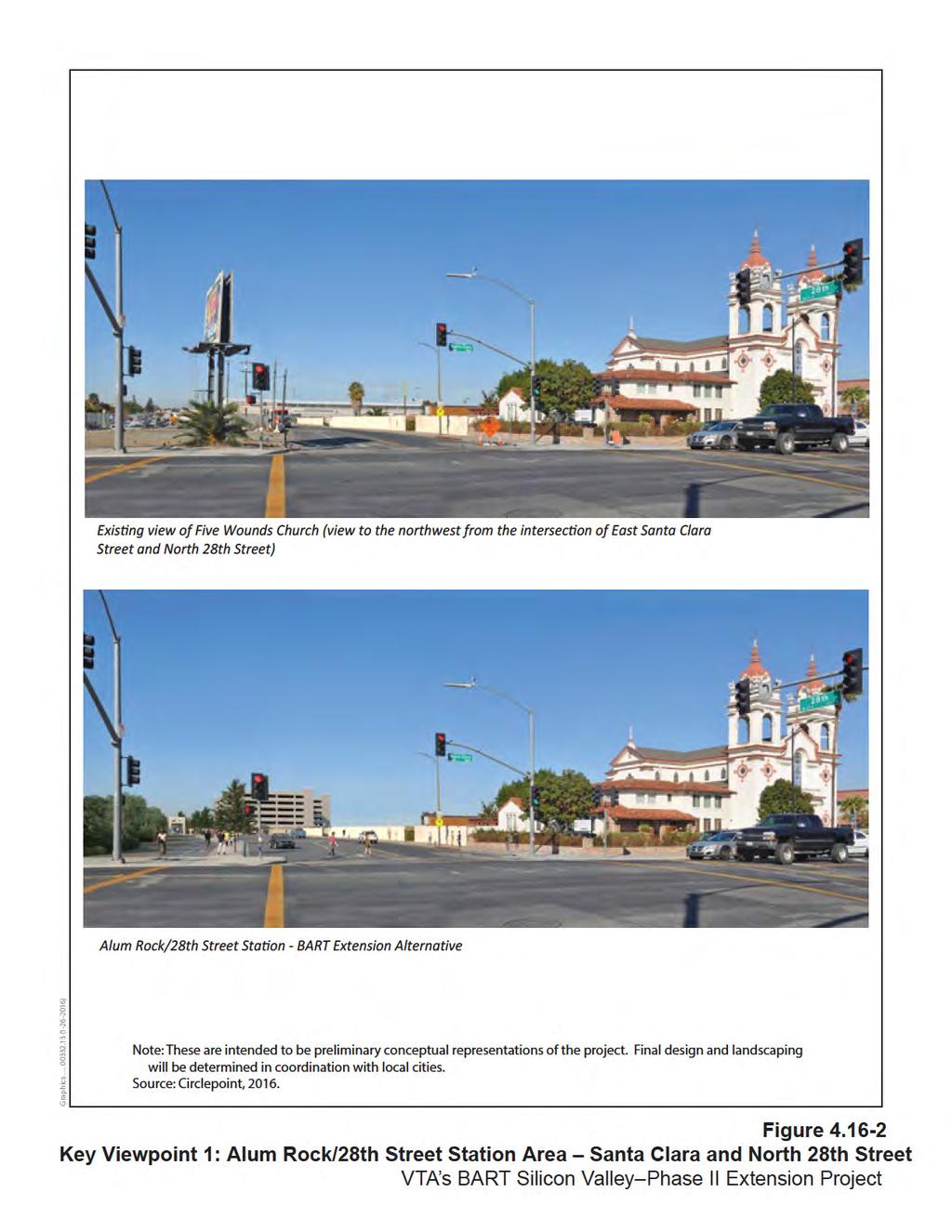
7 Existing lighting in the area is minimal as the majority of land uses are industrial. Streetlights are intermittingly dispersed along the surrounding roadways, and additional lighting is provided by the industrial facilities in the area. Viewers in this area primarily consist of motorists traveling on U.S. 101 and employees working at the industrial sites. Motorists and employees have low viewer sensitivity because motorist views are short in duration, and employees likely spend most of their time indoors focused on their work. Residents typically have moderate to high viewer sensitivity depending on the quality of view. At this location, the quality of views for residents is low, as the nearest residences are over 0.3 mile north of the aboveground features. Given the distance of the BART Extension features from sensitive viewers, and the existing surrounding industrial and transportation uses, moderate viewer sensitivity is assumed. Lighting at the tunnel portal would be directed downward and would not spillover to any residences. The BART Extension would be consistent with the existing industrial and transportation uses in the vicinity of the site. The portal structure would be small and consistent with surrounding structures. The BART Extension would not substantially degrade the existing visual character or quality of the site. Therefore, there would be no adverse effects on visual quality and aesthetics. No mitigation would be required. Alum Rock/28 th Street Station The alignment would continue in a tunnel and transition into Alum Rock/28 th Street Station just east of 28 th Street and north of Santa Clara Street. Aboveground features would include up to a seven-story parking structure, which would be located in the west corner of the station area, as well as a small area of system facilities at the north corner of the parking structure. Industrial uses such as Monarch Truck Dealership, SCS Contractor Service, Mission Concrete, and Granite Counters are currently located onsite. The surrounding visual character is characterized by industrial buildings, warehouses, and storage yards, immediately adjacent to the station site. Low- and medium-density residential uses are located across U.S. 101 to the north and east of the station site, as well as to the west of 28 th Street and the existing out-of-service railroad tracks. The Portuguese Band and Social Center is located to the west of the station site, and the visually prominent Five Wounds Church and associated elementary school are to the southeast. Given the mix of industrial and residential uses, the visual quality of the area is considered moderate. Figure shows the corner of Santa Clara Street and 28 th Street looking north toward the historic Five Wounds Church, the Alum Rock/28 th Street Station site, and associated parking structure. Viewers in this area primarily consist of church attendees, store patrons, passing motorists, residents in the Roosevelt Park neighborhood, pedestrians, and bicyclists. Given the predominately industrial character of the landscape, viewer sensitivity of these groups would be low to moderate
8 Existing lighting in the immediate area consists of overhead street lights on the surrounding roadways, as well as some lighting associated with the existing industrial uses. As shown on Figure , the parking structure would be visible to pedestrians and motorists on surrounding roadways, including Santa Clara and 28 th streets. The multi-level parking structure would be taller than the surrounding one- to three-story industrial warehouses. A pedestrian connection along the south side of the station area at North 28 th Street from Santa Clara Street would be designed as a pedestrian/bicycle/transit gateway into the station area with amenities such as street trees, wide sidewalks, bicycle facilities, and pedestrian-scaled lighting. Station entrances and signage for the Alum Rock/28 th Street Station would be slightly visible from Santa Clara Street at 28 th Street (Figure ). The Five Wounds Church is a key visual resource in the area; however, the rest of the surrounding area has low visual quality. The BART Extension components would be of comparable height and mass to other buildings currently on and surrounding the site, and would improve the visual quality of the area by providing a community-oriented and pedestrian friendly streetscape. The historic Five Wounds Church, at the southeast corner of Santa Clara Street and 28 th Street, is just south of the Alum Rock/28 th Street Station and is considered a City Landmark and architectural resource by the general plan. Because this station would be underground, the parking structure would be the only structure of notable height and mass added to the viewshed. The parking structure would likely partially disrupt existing views of the Five Wounds Church for anyone traveling southbound along North 28 th Street as relatively uninterrupted views of the top half of the Five Wounds Church are visible from the roadway. However, these viewers do not currently have high sensitivity to changes in views and they do not have full views of the church under existing conditions. For pedestrians and motorists on Santa Clara Street and 28 th Street, the area in the immediate vicinity of the church would not be dominated by the parking garage. The station entrances would be closer to the church structure, but are anticipated to be no more than one-story high. Furthermore, the parking structure would be set back at least 200 feet from the church building. The Five Wounds Church fronts Santa Clara Street, and the existing view available from the back of the church is dominated by the existing industrial uses. As a result, the BART Extension would not cause substantial visual degradation to the Five Wounds Church because it would not substantially block views of or from the church for viewers with high sensitivity relative to existing conditions. See Section 4.5, Cultural Resources, for further discussion of the effects of the BART Extension on the Five Wounds Church
9
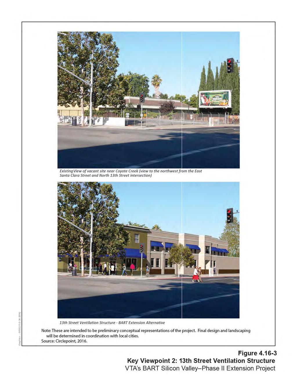
10 Nighttime lighting from the parking structure would be visible to the immediately surrounding areas, which consists of industrial uses, storage yards, parking areas, and the Five Wounds Church. Roosevelt Park is the closest residential neighborhood, approximately 500 feet west of 28 th Street between Julian Street and Santa Clara Street, and is separated from the station area by a block of light industrial uses. It is unlikely that the lighting would be noticeable to residents in the surrounding neighborhoods due to the intervening industrial and commercial buildings between the residences and the new BART station and parking structure. The lighting would, however, be designed to focus on BART Extension facilities and minimize spillover of light and glare into adjacent areas. There are no sensitive viewers in the immediate vicinity that would be adversely affected by spillover lighting. There are no identified scenic vistas in the vicinity of the station site. Additionally, the Alum Rock/28 th Street Station area would incorporate design features such as street trees, wide sidewalks, bicycle facilities, and pedestrian-scaled lighting, which would improve the visual quality of the area. With the incorporation of lighting design to minimize the spillover of light and glare into adjacent areas, no substantial effects would be expected. Therefore, the visual impact would be no adverse effect. No mitigation would be required. 13 th Street Ventilation Structure A ventilation structure would be located at the northwest corner of Santa Clara and 13 th Streets and housed in one building approximately 12 feet high. Currently the site is occupied by a paved parking lot. One- and two-story commercial and commercial/industrial land uses are located adjacent to the site and dominate the visual character of the area. There are some street trees present, as well as overhead billboards and signage for the commercial uses. The visual quality in this area is low. Viewers in this area would primarily consist of motorists and pedestrians traveling on Santa Clara Street and employees/visitors of the commercial establishments. The nearest residences are immediately north of the site along North 13 th Street; however, views of the site are limited due to intervening trees. Given the land uses in the area and types of viewers, viewer sensitivity is low to moderate. The ventilation structure would be consistent with the mass and scale of the surrounding oneand two-story commercial land uses, and would blend visually with the industrial/commercial character of the surrounding environment, as shown in Figure Thus, the 13 th Street Ventilation Structure would not substantially degrade visual quality in the area. Additionally there are no scenic vistas identified in this area, and no major sources of light or glare would be introduced. Therefore, the visual impact would be no adverse effect. No mitigation would be required
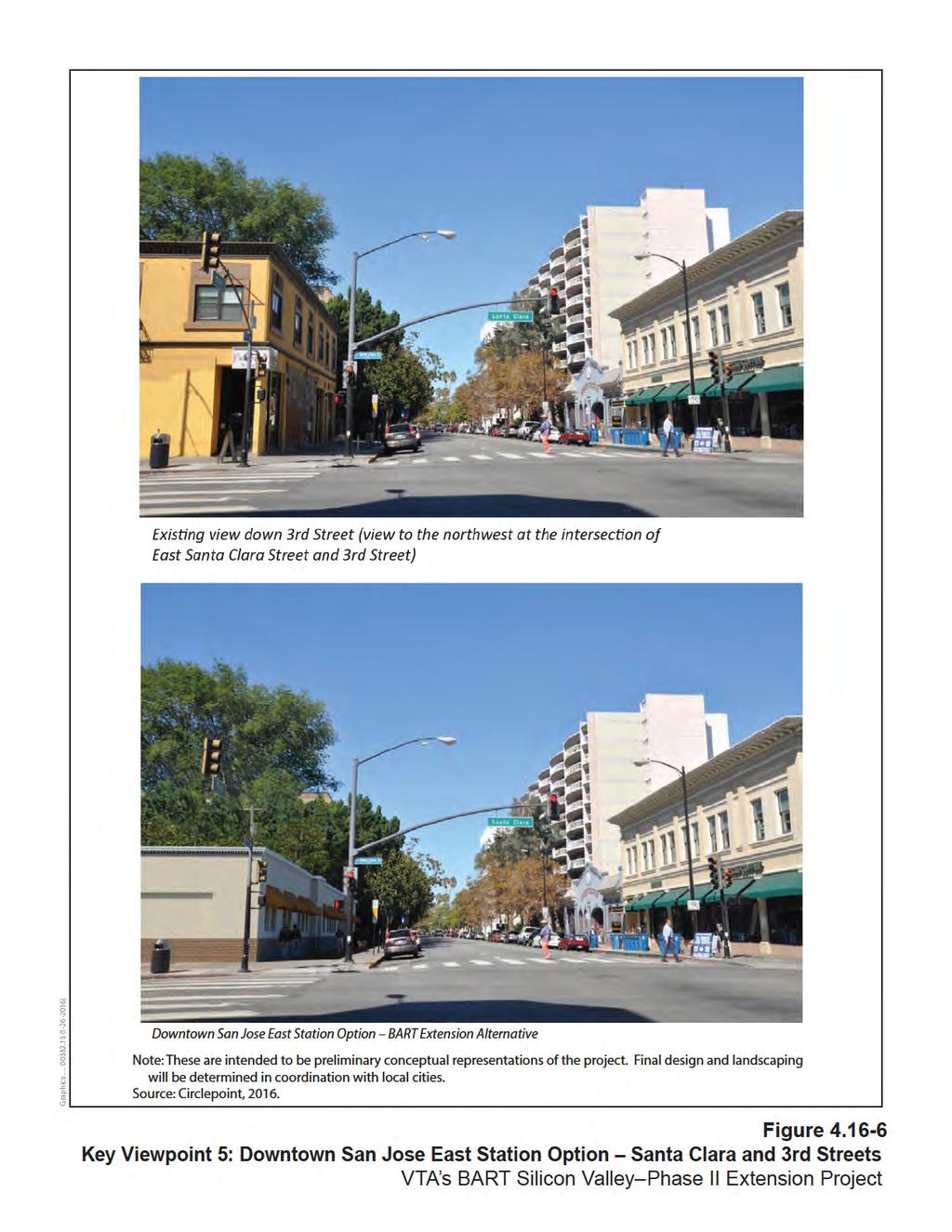
11 Downtown San Jose Station Downtown San Jose Station East Option Aboveground components of the Downtown San Jose Station East Option include street-level portal station entrances, an emergency exhaust generator near the east end of the station, and one emergency ventilation structure, which would be approximately 12 feet high. The station portal entrance locations are being evaluated in sidewalks along Santa Clara Street and near 6 th, 4 th, and 3 rd Streets (see Figures through ). The exhaust generator and ventilation structure would be in vacant areas, commercial parking lots, sidewalks, and landscaped areas along Santa Clara Street. Heading west on Santa Clara Street from 5 th Street, street trees line the sidewalks and views include large institutional and commercial buildings toward downtown San Jose. West of 4 th Street, the density of buildings increases and the styles transition to an old town historic brick façade. Several street trees line both sides of Santa Clara Street, and businesses in this area include restaurants, bars, retailers, and a gas station. Given the more unified nature of the downtown district and the presence of street trees, the visual quality in this area is moderate to high. The primary viewer groups in this location are motorists, pedestrians, bicyclists, restaurant and store patrons, workers, transit riders (bus and light rail), and San Jose State University students and staff. Given the visual appeal of this portion of the station site and types of visitors, viewer sensitivity is moderate to high. Figure depicts the view looking east down Santa Clara Street near its intersection with 4 th Street and shows station portal entrances in the vicinity of City Hall. Figure shows station portal entrances along Santa Clara Street from 4 th Street looking east. As shown, station entrances and signage would be visible aboveground elements. However, the station entrances and signage would not dominate the visual character of the area over the existing business-oriented streetscape and density of the surrounding buildings. The design of the station entrances would be utilitarian and would not distract from the surrounding architecture, or disrupt the area s intact nature or unity. Ventilation structures would be enclosed, and the size and mass of the ventilation structures and station portals would be designed to be unified with the surrounding urban environment so they would not visibly conflict with the urban setting or substantially degrade the existing visual character of the surrounding area (see Figure ). Furthermore, VTA will continue to encourage public input throughout the design process to further ensure the visual character is not adversely affected. Light and glare from the station entrances would be minimal, and would be designed to reduce spillover of light, thereby minimizing any adverse effects of light and glare. Additionally, streetlights and lighting associated with the commercial and local bus and light rail facilities currently exist along the alignment; thus, lighting associated with the station entrances would be consistent with the surrounding lighting landscape, particularly with local transit facilities
12
13
14
15
16 The station portals and ventilation facilities would not have an adverse effect on a scenic vista as no scenic vistas exist in the vicinity nor would the BART Extension components be of a size that could substantially block views. Streetscape improvements would be provided along Santa Clara Street between 7 th Street and 1 st Street to create a pedestrian corridor connecting San Jose City Hall and San Jose State University with the Downtown Commercial District. Streetscape improvements would enhance the visual quality of the area for pedestrian and motorists and would be guided by San Jose s Downtown Master Streetscape Plan. See Section 4.5, Cultural Resources, for a discussion of the effects of this design change on historic architectural resources in the San Jose Downtown Commercial Historic District. Additionally, VTA operates light rail throughout downtown San Jose, including along portions of Santa Clara Street; thus, new aboveground BART components would be consistent with the existing transportation uses in the area. As such, the visual impact would be no adverse effect. No mitigation would be required. Downtown San Jose Station West Option Aboveground features associated with the Downtown San Jose Station West Option would be similar to those for the Downtown San Jose Station East Option. Several station entrance locations are being evaluated at 2 nd Street and 3 rd Street, Market Street, along Fountain Alley close to 2 nd Street, and between mid-block buildings on 1 st Street and Market Street (see Figures and ). An emergency exhaust generator would be located above grade near the northwest corner of Santa Clara Street and 4 th Street. One emergency ventilation facility would be located at each end of the station with a ventilation structure aboveground adjacent to Santa Clara Street. The BART Extension components and existing visual character and quality of the area would be visually identical to that described for the Downtown San Jose Station East Option, with the exception that the mass and scale of buildings increases substantially around 1 st Street and Market Street, and building density decreases. Viewer groups and viewer sensitivity for this portion of the alignment would be similar to those described for the Downtown San Jose Station East Option. As described under the Downtown San Jose Station East Option, station entrances, ventilation structures, and signage would be visible aboveground elements. Figure shows a station entrance/system facility site along Santa Clara Street near Lightson Alley. Figure illustrates the view looking north along 2 nd Street near station entrances on the east side of 2 nd Street. Such BART Extension elements would be designed to maintain consistency with the mass and scale of the surrounding architecture and would not block any views as they would be smaller than the surrounding buildings in the area. Lighting at the station entrances would blend with the existing street lighting in the area and would have minimal effects. Such lighting would be designed to reduce spillover of light during the night, thereby minimizing any adverse effects of light and subsequent glare to adjacent buildings
17
18
19 Streetscape improvements would be provided along Santa Clara Street between 4 th Street and San Pedro and would be guided by San Jose s Downtown Master Streetscape Plan, improving the visual quality of the area for pedestrian and motorists. See Section 4.5, Cultural Resources, for a discussion of the effects of this design change on historic architectural resources in the San Jose Downtown Commercial Historic District. As such, the impact on visual quality and aesthetics would be no adverse effect. No mitigation would be required. Diridon Station Diridon Station South Option The aboveground components at Diridon Station South Option are the same as under the Diridon Station North Option below; however, the locations of systems facilities would be located south and slightly east. System facilities would be the same for both the Twin- Bore and Single-Bore Options, and the alignments would be the same under the Diridon Station South Option. The systems facility site for a traction power substation (TPSS), auxiliary power substation, emergency generator, and ventilation structures would be located at the east end of the station between Autumn Street and Los Gatos Creek. The westernmost fresh air intake and tunnel ventilation shaft would be located just north of the existing Caltrain Station. System facilities sites would also be approximately 12 feet high and surrounded by an approximately 9-foot-high concrete block (CMU) wall. This area currently contains paved parking lots and the existing Diridon Caltrain Station. The visual character along Santa Clara Street in this area is dominated by street trees, the SAP Center building, which is large in mass and scale in comparison with the adjacent historic, large brick Diridon Station, and associated paved parking lots. Autumn Street is defined by low-density industrial-style buildings and few street trees; power lines dominate the sky in this area. Several mature street trees line both sides of Cahill Street and, given that no tall buildings are within this viewshed, views of the open sky and distant hillsides are available. The City has also constructed a green median to serve as a pedestrian linkage for transit riders from Cahill Street to Montgomery Street, along the south side of Stover Street. Given the mix of landscaping, distant views, large buildings, and transportation infrastructure, the visual quality is moderate in this area. The primary viewers are Caltrain train passengers, motorists, SAP event goers, residents, pedestrians, and bicyclists. The nearest residential units are multi-story condominiums approximately 0.10 mile west of the station area along Bush Street on the far side of the existing Caltrain tracks. It is likely that residents dwelling in top floor units immediately adjacent to the Caltrain tracks have views of the station area. Given the mix of transient and resident viewers in this area, viewer sensitivity is moderate
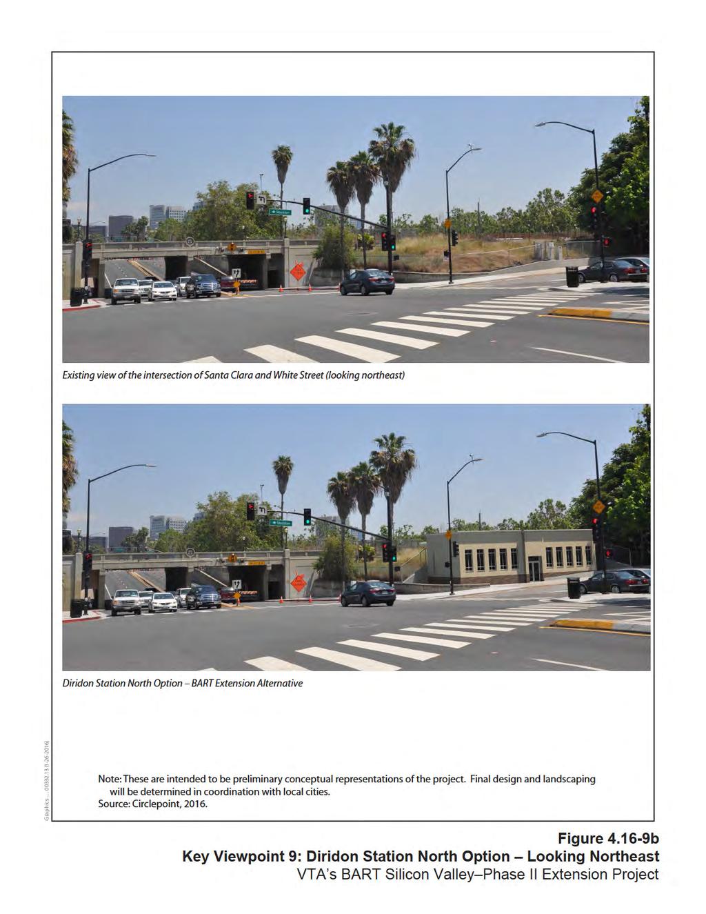
20 Existing lighting onsite consists of street lights, lighting in the paved parking areas, Caltrain station lighting, and the more substantial lighting associated with the SAP Center, particularly during nighttime public events. Station entrances and signage would be visible to pedestrians and motorists along Cahill Street, Montgomery Street, and Autumn Street under both the Diridon Station South and North Options, as shown on Figure a. 1 Under the Diridon Station North Option (below), station above-ground facilities would also be visible from Santa Clara and White Streets (see Figure b). The surrounding area is urbanized, and station entrances and signage would be small and designed to be consistent with the mass and scale of the surrounding urban setting and historic Diridon Station. As such, the station entrances would not substantially disrupt views of the existing historic station or of distant hillsides. The system facilities would be enclosed, but visible to motorists, pedestrians, and bicyclists traveling along Santa Clara Street between Los Gatos Creek and the existing Caltrain corridor. They may also be visible from the existing top-story condominiums located on Bush Street. The surrounding environment in this area is urbanized, and the system facility site would be located within an existing parking lot and shielded from public view by a 9-foot-high CMU wall if publicly visible. It would be designed in mass and scale to maintain consistency with the surrounding environment and would be visually consistent with the surrounding built environment. There are no scenic vistas close to the station site. The visual changes caused by the aboveground station amenities and system facility sites would not substantially degrade the existing visual character or quality of the surrounding area as they would be designed for consistency and unity with surrounding visual character (mass and scale) of the area. Furthermore, transportation amenities, including the San Jose Diridon Transit Center already exist onsite; thus, the addition of new station portals would not introduce substantial sources of new light or glare to the area. Therefore, the impact on visual quality and aesthetics would be no adverse effect. No mitigation would be required. 1 The Diridon Station North Option would be visually similar to the Diridon Station South Option from Cahill Street; thus, there is no separate visual simulation for the Diridon Station North Option in this location
21
22
23 Diridon Station North Option The aboveground components at the Diridon Station North Option include two station entrances, at-grade emergency exhaust ventilation hatches at each end of the station with ventilation shafts extending 12 feet above ground, and a systems facility site for a TPSS, auxiliary power substation, emergency generator, and ventilation structures at the east end of the station between Autumn Street and Montgomery Street. Under the Single-Bore Option, the westernmost fresh air intake and tunnel ventilation shaft would be located on the west side of the Caltrain tracks, adjacent to White Street. Under the Twin-Bore Option, these facilities would be located east and immediately adjacent to the existing Caltrain tracks. Refer to Figure b for a visual simulation of the above-ground systems facility. System facilities sites would be approximately 12 feet high and surrounded by an approximately 9-foot-high CMU wall. This area currently contains paved parking lots and the existing Diridon Caltrain Station. Continuation of Tunnel Alignment On the east side of Stockton Avenue between Schiele Avenue and West Taylor Street, there are three alternate locations for a systems facility site that would house a tunnel ventilation facility, auxiliary power substation, and a gap breaker station. This system facilities site would be similar in size to that described for the 13 th Street Ventilation Structure. The area is currently occupied by industrial uses and consists primarily of surface parking lots. Heading north on Stockton Avenue from Schiele Avenue, several street trees and utility power lines are visible. Single-story industrial buildings are dispersed along the northeast side of Stockton Avenue, and mostly small, single-family residences are visible along the southwest side of Stockton Avenue. Approaching West Taylor Street, billboards and large towers associated with a concrete company are visible. Given the predominately industrial uses in this area, the visual quality is low to moderate. Viewer groups in this area include residents, motorists, workers, and pedestrians and bicyclists. The nearest residents to the system facilities site are directly across Stockton Avenue; therefore, viewer sensitivity is moderate to high. There are no scenic vistas in the vicinity. All three alternate ventilation structure locations would be in the existing industrial area. The surrounding area is urbanized, and the size and mass of the ventilation structure would be designed to be consistent and unified with the surrounding urban environment and would be screened from public view by a CMU wall. Thus, the ventilation structure would not substantially degrade the existing visual quality of the area. Furthermore, the visible structures would be screened from public view, and no substantial light or glare impacts would result. Therefore, the impact on visual quality and aesthetics would be no adverse effect. No mitigation would be required
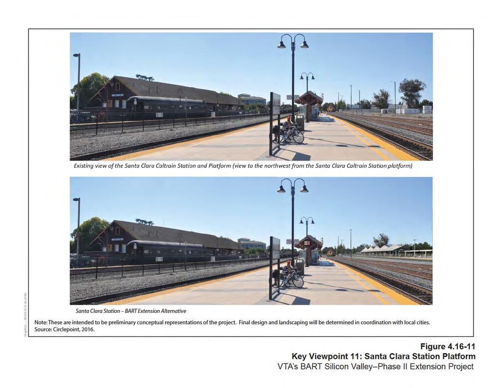
24 City of Santa Clara Visual Study Area Newhall Maintenance Facility The Newhall Maintenance Facility would be constructed on the former Union Pacific Railroad (UPRR) Newhall Yard. The Newhall Maintenance Facility would include maintenance and engineering offices and a yard control tower (up to three stories high). To provide for these functions, several buildings and numerous transfer and storage tracks would be constructed onsite. An onsite system facility would house a TPSS and other required facilities. The visual character in the southwest quadrant adjacent to the Newhall Maintenance Facility site is dominated by modern style multi-story condominiums. Past Campbell Avenue in the northwest quadrant, El Camino Real is a six-lane street separated by a small, landscaped median. There are several street trees lining both sides of El Camino Real, and residential uses transition to large-scale, modern offices, and commercial uses line the north side of the street. Buildings of large mass and scale are also located along the south side of El Camino Real; however, they are set back, which provides an open visual environment. On the northeast side of the Newhall Maintenance Facility in the northeast quadrant, the visual character is defined by overhead power lines, and one- and two-story industrial and commercial buildings. The southeast quadrant is defined by the large Avaya Stadium and some light industrial uses. Viewer groups in this area include motorists, train passengers, residents, students, bicyclists, pedestrians, and workers. Viewer sensitivity along the southwest side of the Newhall Maintenance Facility site is moderate given the residential and commercial uses, and is low to the northeast given the dominance of industrial uses. There are no scenic vistas in the vicinity of the Newhall Maintenance Facility. The Newhall Maintenance Facility would be designed to be consistent with the existing mass and scale of the surrounding areas. Additionally, the facilities would be located within the existing UPRR Newhall Yard and thus would blend with the existing visual character of the area. Therefore, the Newhall Maintenance Facility would not substantially degrade the existing visual character or quality of the surrounding area. The yard control tower would be up to three stories tall and would be the most visible facility to offsite viewers. However, given the urban/industrial landscape in the area, no substantial adverse visual effects would be expected. Additionally, the only buildings that are directly adjacent to the Newhall Maintenance Facility are the multi-story condominiums, along the southwest side of the facilities. Given that these are shielded from the system facilities site by a large retaining wall, no substantial light or glare impacts are anticipated. Therefore, the impact on visual quality and aesthetics would be no adverse effects. No mitigation would be required. Santa Clara Station The Santa Clara Station would be at grade, centered at the west end of Brokaw Road, and would contain a boarding platform with a mezzanine level one level below grade. The
25 systems facility at the Santa Clara Station would be no more than 20 feet high. Figures and represent typical views of the Santa Clara Station area. A parking structure with up to five levels would be located north of Brokaw Road and east of the Caltrain tracks and would accommodate approximately 500 BART park-and-ride parking spaces. The area was formerly occupied by a FedEx shipping and receiving facility but is currently vacant, and a large retail center is immediately adjacent to the northwest. Industrial buildings and Mineta San Jose International Airport are located to the north and northeast. The existing Caltrain tracks and station are located to the south. The parking structure would be constructed in a primarily industrial area, and the bulk and height of the structures would be similar to those of the existing industrial buildings. Given that the uses currently onsite and immediately adjacent to the new station and parking structure are primarily commercial and industrial, visual quality in the area is low to moderate. Viewer groups in this area primarily consist of motorists, train passengers, pedestrians, bicyclists, and workers and visitors to the police station and the commercial/industrial areas. Given the transient nature of viewer groups, viewer sensitivity is low to moderate. The BART station and new parking structure would be a dominant visual feature in this area. The surrounding area is developed with existing institutional and industrial uses, roadways, railroad right-of-way, and other transportation-related infrastructure. The addition of the station and parking structure would be visually compatible with the surrounding land uses, and would not substantially degrade the existing visual character or quality of the surrounding area. The station would strengthen the railroad/transportation aesthetic of the immediate area. The BART station and associated components would create a denser urban aesthetic environment, and the facilities would not block any scenic views as none have been identified in the vicinity. At night, lighting from the BART station and parking structure would be designed to maintain consistency with the existing Santa Clara Caltrain Station lighting and would help to create a safe environment. There are no light-sensitive land uses (i.e., residences) in the immediate vicinity of the new facilities, and design measures would be implemented to reduce spillover of light. Furthermore, the area already has existing lighting associated with the Santa Clara Police Station and streetlights along roadways and sidewalks. Therefore, the impact on visual quality and aesthetics would be no adverse effect. No mitigation would be required
26
27
28 Tree Removal As described in detail in Section 5.5.4, Biological Resources and Wetlands, construction would include removing street- and other trees to accommodate BART Extension features and clear construction staging areas. Existing tree species occur within or in the vicinity of the Alum Rock/28 th Street, Downtown San Jose, Diridon, and Santa Clara Station areas are predominantly landscaping trees and would be removed during construction. As described in Mitigation Measure BIO-CNST-H (see Chapter 5, Section 5.5.4), tree removal would comply with the overall intent of local tree ordinances, and therefore replacement trees would be planted or in lieu fees paid to mitigate the effects. Therefore, there would be no adverse effect NEPA Conclusion The BART Extension Alternative impact on aesthetics and visual quality would result in no adverse effect. Trees that would be removed due to construction activities would be inventoried and noted on construction plans before construction begins. Any trees that are removed will be compensated for according to local tree ordinances (refer to Mitigation Measure BIO-CNST-I); no additional mitigation would be required. VTA would continue to work with city, community, and business groups in developing a BART Extension Alternative that would be integrated into the surrounding streetscape
6.14 Visual Quality and Aesthetics
 6.14 6.14.1 Introduction This section describes impacts under CEQA that would result from construction and operation of the CEQA Alternatives. 6.14.1.1 Regulatory Setting State There are no federal or
4.11 Land Use Introduction Environmental and Regulatory Setting Environmental Setting
 4.11 4.11.1 Introduction This section describes the affected environment and environmental consequences related to land use from operations of the NEPA Alternatives. Information regarding land use and
4.17 VISUAL QUALITY AND AESTHETICS
 4.17 VISUAL QUALITY AND AESTHETICS 4.17.1 INTRODUCTION AND METHODOLOGY This section assesses the visual affects of both the Baseline and BART alternatives. The visual analysis characterizes the SVRTC in
Section 3.16 Visual Quality
 Chapter 3 Affected Environment, Environmental Consequences, and Mitigation Measures Section 3.16 Visual Quality Introduction This section discusses existing conditions, effects and mitigation measures
4.0 AFFECTED ENVIRONMENT AND ENVIRONMENTAL CONSEQUENCES
 4.0 AFFECTED ENVIRONMENT AND ENVIRONMENTAL CONSEQUENCES The following sections discuss the impacts associated with environmental resources for the tunneling method Alternatives A and B. The construction
4.14 VISUAL QUALITY AND AESTHETICS
 4.14 VISUAL QUALITY AND AESTHETICS This section describes the existing aesthetic characteristics along the SVRTC including visual quality, prominent features, and scenic resources. This section also describes
Visual and Aesthetic Resources
 Visual and Aesthetic Resources 7.1 INTRODUCTION This chapter evaluates the effects of the Modified Design on visual and aesthetic resources, in comparison to the effects of 2004 FEIS Design. The 2004 FEIS
4.1 AESTHETICS AND VISUAL QUALITY
 SCOPE AND METHODOLOGY 4.1 AESTHETICS AND VISUAL QUALITY This section evaluates the potential impacts to aesthetics and visual quality. Aesthetics refers to visual resources and the quality of what can
APPENDIX D: Visual and Aesthetic Conditions for NCCU Station Refinement. Durham-Orange Light Rail Transit Project
 APPENDIX D: Visual and Aesthetic Conditions for NCCU Station Refinement Durham-Orange Light Rail Transit Project October 2016 1. Introduction The Combined FEIS/ROD summarizes the effects of the D-O LRT
Nob Hill Pipeline Improvements Project EIR
 Section 3.1 Aesthetics This section addresses the visual aspects that may affect the views experienced by the public, including the potential to impact the existing character of each area that comprises
3.1 Aesthetics, Light, and Glare
 3.1 3.1.1 Introduction This section describes the existing aesthetics, light, and glare setting and potential effects from project implementation on visual resources and the site and its surroundings.
920 BAYSWATER AVENUE PROJECT
 920 BAYSWATER AVENUE PROJECT VISUAL ASSESSMENT Prepared for the City of Burlingame Prepared by Circlepoint 46 S First Street, San Jose, CA 95113 June 2018 This page intentionally left blank. 920 Bayswater
3.17 VISUAL QUALITY. Introduction
 3.17 VISUAL QUALITY Introduction This section describes the existing visual setting and effects of the proposed project on the visual quality of the Santa Clara-Alum Rock Corridor. Where potential impacts
5.4.6 Cumulative Operational Impacts
 5.4.5.2 Visual Character Impacts The proposed project is located in greater downtown Los Angeles, which is a dynamic environment where new projects are constructed on an ongoing basis. Additional development
3.5 VISUAL AND AESTHETIC QUALITIES
 3.5 VISUAL AND AESTHETIC QUALITIES 3.5.1 Introduction to Analysis 3.5.1.1 Summary of Results The Preferred Alternative would represent a minimal change to the visual character of the existing rail corridor.
6.11 Land Use Introduction Regulatory Setting Regional Plans and Policies. Santa Clara Valley Transportation Authority
 6.11 6.11.1 Introduction This section discusses existing conditions and the regulatory setting regarding land use and describes impacts under CEQA that would result from construction and operation of the
3.1 AESTHETICS Background and Methodology
 3.1 AESTHETICS 3.1.1 Background and Methodology 3.1.1.1 Regulatory Context The California Environmental Quality Act (CEQA) requires that project sponsors evaluate the project s potential to cause aesthetic
3.1 AESTHETICS AND VISUAL RESOURCES
 3.1 AESTHETICS AND VISUAL RESOURCES This section examines the potential for the proposed Project to create aesthetic and visual impacts as defined by the California Environmental Quality Act (CEQA) as
WESTSIDE SUBWAY EXTENSION PROJECT. Addendum to the Visual and Aesthetic Impacts Technical Report
 PROJECT to the Visual and Aesthetic Impacts Technical Report August 2011 Visual and Aesthetic Impacts Technical Report SUMMARY On October 28, 2010, the Metro Board selected the Westwood/VA Hospital Extension
5.9 LAND USE INTRODUCTION METHODOLOGY
 5.9 LAND USE 5.9.1 INTRODUCTION An adverse effect on land use would occur if the alternatives physically divide an established community; change land use in a manner that would be incompatible with surrounding
4.1 Aesthetics Setting. a. Visual Character
 Environmental Impact Analysis Aesthetics 4.1 Aesthetics This section analyzes the proposed Specific Plan s impacts related to aesthetics, including the existing visual character of and scenic views in
Table of Contents. Elm Avenue Improvement Plan City of Waco, Texas. Introduction 1. Existing Context 1 Figure 1 2.
 Table of Contents Introduction 1 Existing Context 1 Figure 1 2 Plan Guidelines 3 Future Urban Form 4 The West-End 4 Main Street 6 The East-End 7 Figure 2 9 Public Improvement Recommendations 7 General
Community Working Group Workshops - Workshop Summary September TOD Corridor Strategy and Access Planning Study. Workshop Introduction
 Community Working Group Workshops - Workshop Summary September 11-13 2018 TOD Corridor Strategy and Access Planning Study With VTA s BART Phase II (the Study), VTA seeks to build upon existing transportation
5.8 Visual Resources and Aesthetic Qualities
 I-70 East Supplemental Draft EIS 5.8 Visual Resources and Aesthetic Qualities 5.8 Visual Resources and Aesthetic Qualities This section discusses the visual resources and aesthetic qualities of the study
4.13 Security and System Safety
 4.13 4.13.1 Introduction This section describes the affected environment and environmental consequences related to security and system safety from operations of the NEPA Alternatives. Information regarding
The impacts examined herein take into account two attributes of aesthetic values:
 IV. ENVIRONMENTAL IMPACT ANALYSIS This section addresses the potential impacts to views and aesthetics as a result of the proposed Project at the Project Site and the development scenarios analyzed for
GENERAL PLAN CONSISTENCY ANALYSIS
 GENERAL PLAN CONSISTENCY ANALYSIS Prepared by Planning Staff 10/28/2013 APPLICABLE GOALS, POLICIES AND PROGRAMS FROM the LAND USE CHAPTER Goal LU-1 Policy LU-1.1 Policy LU-1.2 Goal LU-2 Protect the character
VISUAL RESOURCES 1. INTRODUCTION 2. EXISTING CONDITIONS. a. Visual Character
 IV.A VISUAL RESOURCES 1. INTRODUCTION This section addresses the potential changes in visual character that would result from implementation of the proposed Wilshire and La Brea Project. Also evaluated
4.2 Aesthetics and Visual Quality
 This section describes the environmental and regulatory setting for aesthetics and visual quality related to the Project, the impacts that may result, and feasible and appropriate mitigation measures that
Gold Line Bus Rapid Transit Transit Oriented Development (BRTOD) Helmo Station Area Plan
 Helmo Station Area Plan") Appendix F Gold Line Bus Rapid Transit Transit Oriented Development (BRTOD) Helmo Station Area Plan Introduction and Purpose of the Plan The Gold Line Bus Rapid Transit facility is an eleven-mile dedicated
Appendix F Gold Line Bus Rapid Transit Transit Oriented Development (BRTOD) Helmo Station Area Plan Introduction and Purpose of the Plan The Gold Line Bus Rapid Transit facility is an eleven-mile dedicated
22a. Existing Condition. 22b. Simulation of NE 20th Street Alternative (D3)
") Appendix F4.5 Visual Consistency and Key Observation Point Analyses EXHIBIT F4.5-22 Key Observation Point 22 (looking east along NE 20th Street) 22a. Existing Condition 22b. Simulation of NE 20th Street
Appendix F4.5 Visual Consistency and Key Observation Point Analyses EXHIBIT F4.5-22 Key Observation Point 22 (looking east along NE 20th Street) 22a. Existing Condition 22b. Simulation of NE 20th Street
Visual and Aesthetics
 Such a connection could accommodate timed transfers and improve connections between local transit service and Presidio Shuttle service. Level of Service The results of the analysis are provided on a route-by-route
Policies and Code Intent Sections Related to Town Center
 Policies and Code Intent Sections Related to Town Center The Town Center Vision is scattered throughout the Comprehensive Plan, development code and the 1994 Town Center Plan. What follows are sections
ENVIRONMENTAL IMPACT ANALYSIS
 IV. ENVIRONMENTAL IMPACT ANALYSIS A. AESTHETICS This section addresses the potential impacts to aesthetics and views that could result from the proposed project, including development of the Add Area,
IV.B. VISUAL RESOURCES
 IV.B. VISUAL RESOURCES ENVIRONMENTAL SETTING Existing Visual Character Project Site The project site is located at 17331-17333 Tramonto Drive in the Pacific Palisades community of the City of Los Angeles
APPENDIX H. VISUAL AND AESTHETICS TECHNICAL MEMORANDUM
 APPENDIX H. VISUAL AND AESTHETICS TECHNICAL MEMORANDUM Environmental Assessment Northwest Phase II Light Rail Extension September 2018 This page is intentionally left blank. Environmental Assessment Northwest
Figure East End of 2 nd Street Tunnel
 Figure 4-13. East End of 2 nd Street Tunnel Figure 4-14. West End of 3 rd Street Tunnel Draft Environmental Impact Statement/Environmental Impact Report Page 23 Figure 4-15. 3 rd Street Corridor and East
4.5 Visual and Aesthetic Resources
 4.5 Visual and Aesthetic Resources 4.5.1 Summary Table 4.5-1 shows how many homes would have reduced visual quality under each alternative. Measures like the ones suggested in Section 4.5.5, Potential
3.5. Visual and Aesthetic Qualities
 3.5 Visual and Aesthetic Qualities 3.5 Visual and Aesthetic Qualities 3.5.1 Introduction to Analysis 3.5.1.1 Summary of Results Implementation of the Preferred Alternative would involve the installation
Table L-1 Summary Action Strategy. Action Item Timing Status Responsible Agency
 CHAPTER 4: CIRCULATION ELEMENT ISSUE #1: MAJOR THOROUFARES AND TRANSPORTATION ROUTES A balanced transportation system for Fontana is provided that meets the mobility needs of current and future residents
5.1 AESTHETICS AND VISUAL RESOURCES Physical Setting
 5.1 AESTHETICS AND VISUAL RESOURCES 5.1.1 Physical Setting Aesthetic values are an important aspect in establishing the identity, sense of place, and quality of life in a community. Natural features in
Hockessin Community Redevelopment Plan
 Hockessin Community Redevelopment Plan 3.1 Introduction The Community Redevelopment Plan for the Village of Hockessin is the result of the people s vision for a distinct village center that serves as the
CHAPTER 10 AESTHETICS
 CHAPTER 10 AESTHETICS CHAPTER 10 AESTHETICS This section identifies and evaluates key visual resources in the project area to determine the degree of visual impact that would be attributable to the project.
WEST LOOP DESIGN GUIDELINES CHECKLIST
 WEST LOOP DESIGN GUIDELINES CHECKLIST Section 1.0 General Strategies 1.1 DESIGN EXCELLENCE: ENCOURAGE HIGH QUALITY AND INNOVATIVE DESIGN OF NEW BUILDINGS WITHIN THE WEST LOOP WITHOUT BEING PRESCRIPTIVE
The transportation system in a community is an
 7 TRANSPORTATION The transportation system in a community is an important factor contributing to the quality of life of the residents. Without a sound transportation system to bring both goods and patrons
There are no buildings on the site, which is entirely paved. Buildings east of the site consist of one- to three-story industrial-type buildings.
 4.0 Affected Environment 4.2.18 Maintenance and Operations Facility Sites The proposed locations for future vehicle storage and maintenance are shown on Figure 2-48. Additional storage and maintenance
3.1 AESTHETICS ENVIRONMENTAL SETTING VISUAL CHARACTER OF THE PROJECT SITE VISUAL CHARACTER OF THE SURROUNDING AREA
 3.1 AESTHETICS Aesthetic or visual resources are the natural and human-built features of the landscape that contribute to the public s appreciation and enjoyment of the aesthetic environment. This section
5.11 AESTHETICS ENVIRONMENTAL SETTING
 5.11 AESTHETICS ENVIRONMENTAL SETTING The lies on a relatively flat valley floor surrounded by rugged hills and mountains. The topography of the planning area is defined by the Box Springs Mountains and
3.5 VISUAL AND AESTHETIC QUALITIES
 3.5 VISUAL AND AESTHETIC QUALITIES 3.5.1 Introduction to Analysis A commuter rail transit project is a major investment in a community s future. How it impacts the visual qualities of the natural and cultural
New land uses or changes to existing land uses in the Phase 1 area since certification of the FEIR and SEIR-1 are discussed below for each city.
 4.12 LAND USE 4.12.1 INTRODUCTION This section provides relevant updates to information presented in the FEIR and SEIR-1 related to land use and the consistency of Phase 1 with local and regional planning
4 LAND USE DESIGNATIONS
 4 LAND USE DESIGNATIONS Chapter 4 describes the land use designations and densities that will implement the development vision for North Burlingame outlined in Chapter 3. Land use densities are described
Visual Impact Assessment 830 Pratt Avenue St Helena, CA
 Visual Impact Assessment 830 Pratt Avenue St Helena, CA 1. Introduction The following aesthetic visual impact assessment has been prepared pursuant to the California Environmental Quality Act (CEQA). The
Bel-Air Lexus Automobile Service Station
 Bel-Air Lexus Automobile Service Station Design Brief 443-447 McArthur Avenue Ottawa April 30, 2015 14-1299-MCA Site Details Application: Site Plan Control Legal Description and Municipal Addresses: 443
A. WHAT IS A GENERAL PLAN?
 I. Introduction A. WHAT IS A GENERAL PLAN? A general plan is the planning guideline for the future of a city. It contains goals and policies which regulate urban development, the protection of the natural
Town Center. Block 5 Existing multifamily residential units are expected to remain.
 Area Guidelines Germantown s districts should be developed as distinct communities with unique features that are supported through the guidelines. The guidelines not only help distinguish these districts
Environmental Setting, Impacts, and Mitigation Measures
 CHAPTER 3 Environmental Setting, Impacts, and Mitigation Measures Format of the Environmental Analysis The assessment of each environmental resource discussed in this chapter includes the following: Environmental
EXISTING COMPREHENSIVE PLAN
 EXISTING COMPREHENSIVE PLAN Town Center Land Use Element: V. LAND USE POLICIES Town Center Mercer Island's business district vision as described in "Your Mercer Island Citizen-Designed Downtown" was an
3.1 community vision. 3.3 required plan elements
 Chapter 3 Community Form 3.1 community vision 3.2 Parks & landscaping concepts 3.3 required plan elements D R A F T 20 Community Form Chapter 3 3.0 Community form 3.1 community vision The Specific Plan
2.2.2 Mixed Urban/Community Core Districts
 corridor is visible only from streets that cross them. In others, the rights-of-way are paralleled by frontage roads from which the rail corridors are fully visible to road users. The views within the
B. PROPOSED REFINEMENTS POTENTIALLY AFFECTING URBAN DESIGN AND VISUAL RESOURCES
 Chapter 4: Urban Design and Visual Resources A. CONCLUSIONS OF THE FGEIS The FGEIS concluded that the Approved Plan will not result in any significant adverse impact on urban design or visual resources.
Regency Developments. Urban Design Brief. Holyrood DC2 Rezoning
 Regency Developments Urban Design Brief Holyrood DC2 Rezoning Stantec Consulting Ltd. 7-31-2017 1. Overview Regency Developments intends to rezone the lands located at 8510 and 8511 93 Avenue, within the
FRUITVALE TRANSIT VILLAGE (Phase 2) Residential Project
 Residential Project") FRUITVALE TRANSIT VILLAGE (Phase 2) Residential Project DEVELOPER: SIGNATURE PROPERTIES ARCHITECT: HKIT ARCHITECTS April 23, 2010 TABLE OF CONTENTS 3 Vision 4 Description of Site 5 Guiding Concepts 6
FRUITVALE TRANSIT VILLAGE (Phase 2) Residential Project DEVELOPER: SIGNATURE PROPERTIES ARCHITECT: HKIT ARCHITECTS April 23, 2010 TABLE OF CONTENTS 3 Vision 4 Description of Site 5 Guiding Concepts 6
RZC Public View Corridors and Gateways
 RZC 21.42 Public View Corridors and Gateways 21.42.010 Purpose 21.42.020 Scope and Authority 21.42.030 Administration 21.42.040 Gateways Design 21.42.050 Unidentified Public Views 21.42.060 Identification
WESTSIDE SUBWAY EXTENSION August 13, 2010 Page 4-25
 4.0 Affected Environment There are also views to and from the south that include some of the tall buildings in Downtown LA, including the Los Angeles Metro building (Figure 4-39). Figure 4-40 shows a view
CHAPTER 4.0: REVISIONS TO THE DRAFT SEIR
 CHAPTER 4.0: REVISIONS TO THE DRAFT SEIR This chapter contains the revisions to the Draft SEIR. Text that has been deleted from the draft document is shown with a red line through the deleted text. Text
2.0 AREA PLANS. Lakeside Business District. Lakeside Business District Land Use Categories:
 Lakeside Business District Lakeside Business District Land Use Categories: Campus Commercial Campus Commercial means a mixture of uses which includes corporate offices, office parks, hotels, commercial,
Bayshore Boulevard Home Improvement District Design Guidelines
 Bayshore Boulevard Home Improvement District Design Guidelines guidelines for New construction projects and major alterations IN the bayshore boulevard home improvement special use DISTRICT SAN FRANCISCO
THE PLANNING AREA 2.1 PLANNING AREA LOCATION
 2. The Planning Area Brisbane Baylands Specific Plan 21 2 THE PLANNING AREA 2.1 PLANNING AREA LOCATION The Baylands is located approximately midway between San Francisco s central business district and
IV. ENVIRONMENTAL IMPACT ANALYSIS B. AESTHETICS 1. SHADE/SHADOW
 IV. ENVIRONMENTAL IMPACT ANALYSIS B. AESTHETICS 1. SHADE/SHADOW ENVIRONMENTAL SETTING The issue of shade and shadow pertains to the blockage of direct sunlight by onsite buildings, which affect adjacent
IV. ENVIRONMENTAL IMPACT ANALYSIS B. AESTHETICS 1. VIEWS
 IV. ENVIRONMENTAL IMPACT ANALYSIS B. AESTHETICS 1. VIEWS ENVIRONMENTAL SETTING Existing Visual Character Project Site The project site is located at 10250 Wilshire Boulevard in the Westwood community of
Chapter 2, Section C: Urban Design and Visual Resources A. INTRODUCTION
 Chapter 2, Section C: Urban Design and Visual Resources A. INTRODUCTION This attachment considers the potential of the proposed East River Waterfront Access Project at Peck Slip to effect urban design
V. Urban Design A. INTRODUCTION B. CITY IMAGE
 V. Urban Design A. INTRODUCTION Urban design refers to the physical form and development of a city from the individual neighborhood to the overall city scape. In the largest sense, urban design encompasses
Transportation. Strategies for Action
 Transportation A major priority for the Overlake Neighborhood is to develop a multimodal transportation system. To achieve this system, a balance has to be found among travel, circulation and access needs;
URBAN DESIGN BRIEF URBAN DESIGN BRIEF 721 FRANKLIN BLVD, CAMBRIDGE August 2018
 URBAN DESIGN BRIEF URBAN DESIGN BRIEF 721 FRANKLIN BLVD, CAMBRIDGE August 2018 DESIGN BRIEF CONTENTS PART A 1.0 INTRODUCTION 2.0 DESCRIPTION & ANALYSIS OF SITE CONTEXT 3.0 DESIGN CONSTRAINTS AND OPPORTUNITIES
Clairtrell Area Context Plan
 Clairtrell Area Context Plan March 2005 Urban Development Services City Planning Contents 1. Introduction... 4 2. Development Structure... 6 2.1 Streets... 7 2.1.1 Sheppard Avenue and Bayview Avenue...
IV. Environmental Impact Analysis B. Aesthetics. 1. Visual Quality/Views. a. Introduction
 IV. Environmental Impact Analysis B. Aesthetics 1. Visual Quality/Views a. Introduction This section addresses the potential impacts that could result from the Proposed Project with regard to visual quality
Chapter 4. Linking Land Use with Transportation. Chapter 4
 Chapter 4 Linking Land Use with Transportation Chapter 4 59 Chapter 4 Linking Land Use with Transportation Community Design and Transportation Program Introduction Since the 1950s, the predominant development
Strategic Growth Area #1 Northampton Boulevard Corridor Area
 Strategic Growth Area #1 Northampton Boulevard Corridor Area Description Strategic Growth Area #1 has established itself as a major employment center in Southside Hampton Roads. Opportunities exist to
Land Use. Hardware Street Vendor Mixed-Use
 Land Use Definition Land Use is the way a piece of real estate is utilized. Existing, proposed, and adopted land uses all play a role in the planning process. Once a land use plan is adopted, the next
CHAPTER 7: Transportation, Mobility and Circulation
 AGLE AREA COMMUNITY Plan CHAPTER 7 CHAPTER 7: Transportation, Mobility and Circulation Transportation, Mobility and Circulation The purpose of the Transportation, Mobility and Circulation Chapter is to
5.1 AESTHETICS Environmental Setting Scenic Views FONTANA FORWARD GENERAL PLAN UPDATE DRAFT ENVIRONMENTAL IMPACT REPORT
 5.1 AESTHETICS This section describes the City s scenic resources, and landscape and neighborhood characteristics, and addresses the potential impacts on aesthetic and visual resources associated with
AMEND DMENT H HOSPITAL
 AMEND DMENT TO LAND USE PLAN ELEMENT VILLAGE OF RIDGEWOOD MASTER PLAN H HOSPITAL ZONE DISTRICT Village of Ridgewood Planning Board February 28, 2014with technical revisions from June 9, 2014 Planning Board
Civic Center District
 Civic Center District The Civic Center district is the civic and social heart of Warrenville, containing such public buildings as the City Hall, Warrenville Public Library, Police Station, Park District
6.8 SCENIC HIGHWAYS Introduction
 6.8 SCENIC HIGHWAYS 6.8.1 Introduction The Scenic Highways Element is an optional General Plan element authorized by Section 65303 of the Government Code. The Scenic Highways Element is intended to establish
URBAN DESIGN BRIEF. 2136&2148 Trafalgar Road. Town of Oakville
 URBAN DESIGN BRIEF 2136&2148 Trafalgar Road Town of Oakville Prepared By: METROPOLITAN CONSULTING INC For 2500674 Ontario Inc November 2016 TABLE OF CONTENTS Page No. 1.0 Introduction/Description of Subject
DRAFT ROOSEVELT ROAD. District Recommendations. Figure 5.23 The Roosevelt Road Corridor
 CHAPTER 5 Figure 5.23 The Road Corridor Road will develop as a mixed-use corridor, emphasizing regional retail, west of the river and mixed-use development east of the river. KEY RECOMMENDATIONS 1. High
Community Design Plan
 Gardena General Plan 2006 Authority While the is not a required element of a General Plan, it is included because improving the community appearance and image is paramount to the overall quality of life
ATTACHMENT A. SILVERDALE DESIGN STANDARDS Amendments to the Waaga Way Town Center Chapter
 ATTACHMENT A SILVERDALE DESIGN STANDARDS Amendments to the Waaga Way Town Center Chapter Chapter 10. Waaga Way Town Center 10.1 Physical Identity Elements & Opportunities The Waaga Way Town Center includes
I539. Smales 2 Precinct
 I539. Smales 2 Precinct I539.1. Precinct Description The Smales 2 Precinct applies to a 4.8 hectare block of land located on the southern side of Northcote Road and fronting Lake Pupuke, Takapuna. The
4.1 AESTHETICS WATSON INDUSTRIAL PARK ENVIRONMENTAL IMPACT REPORT EXISTING CONDITIONS
 This Subsection describes the aesthetic qualities and visual resources present on the Project site and in the site s vicinity and evaluates the potential effects that the Project may have on these resources.
4.1 AESTHETICS EXISTING ENVIRONMENTAL SETTING ALAMITOS BAY MARINA REHABILITATION PROJECT CITY OF LONG BEACH
 4.1 AESTHETICS This section provides a discussion of the existing visual and aesthetic resources on site and in the surrounding area as well as an analysis of potential impacts from implementation of the
Chapter 3: Office & Office Mixed-Use Project Types
 Chapter Contents Purpose... 3-2 Applicability and Use Types...3-3 (1) Site Design...3-4 Building Placement and Orientation...3-5 Circulation and Vehicle Parking...3-6 Bicycle/Pedestrian Amenities...3-8
SECTION TWO: Urban Design Concepts
 SECTION TWO: Urban Design Concepts The Gardnerville Plan for Prosperity shapes economic opportunities presented by regional growth. The Urban Design Concepts provide policies and concepts for land use,
4.1 AESTHETICS. A. Regulatory Framework
 4.1 This section includes a description of the existing visual setting of the project site and an analysis of the effects the proposed project would have on aesthetics in the project vicinity. Aesthetics
VISION AND GUIDING DESIGN PRINCIPLES
 pleasure point commercial corridor VISION AND GUIDING DESIGN PRINCIPLES Public Draft November 26, 2018 County of Santa Cruz with assistance from MIG CONTENTS PART I: INTRODUCTION AND VISION... 3 Community
DRAFT. October Wheaton. Design Guidelines
 October 2011 DRAFT Wheaton Design Guidelines 2 Draft - Design Guidelines - Wheaton Sector Plan Contents 04 Section 1: Introduction 06 Section 2: Context 08 Section 3: Design Guidelines 09 Goal 1: Create
Appendix D North Road/N. Leroy Street Subarea Plan
 North Road/N. Leroy Street Subarea Plan INTRODUCTION The City of Fenton Master Plan was updated in 1996 and included a subarea plan for the North Leroy Street area of the City. It was recognized at that
Community Design. Our Use of Land. Introduction
 Community Design Our Use of Land Introduction This element addresses the physical form of the natural environment and the built form of the City. The major features that give San Rafael its visual character
East Corridor Final Environmental Impact Statement
 East Corridor Final Environmental Impact Statement Alternatives Considered Operating Plan The requirements for opening day operations versus year 2030 are based on ridership and operations. Opening day
Planning Districts INTRODUCTION
 INTRODUCTION To facilitate detailed examination of development prospects for all areas of the community, Delano has been divided into 14 planning districts. The location of these planning districts is