MIAMI WORKSHOP: URBAN RESILIENCE BEIJING UNIVERSITY OF CIVIL ENGINEERING AND ARCHITECTURE & UNIVERSITY OF MIAMI
|
|
|
- Marilynn Moody
- 5 years ago
- Views:
Transcription


 BUCEA: Li Chunqin (lichunqing@bucea.")

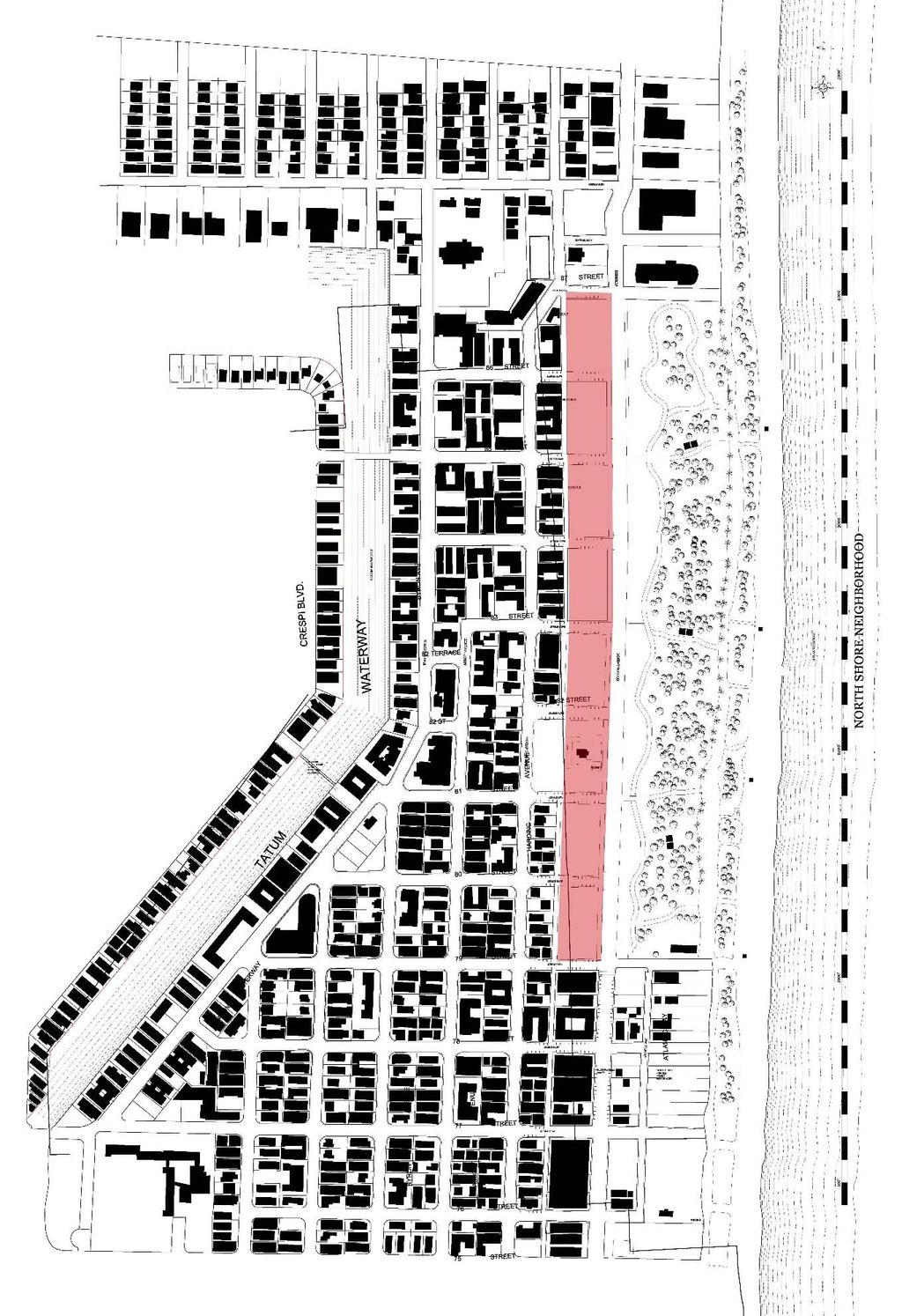
1 MIAMI WORKSHOP: URBAN RESILIENCE BEIJING UNIVERSITY OF CIVIL ENGINEERING AND ARCHITECTURE & UNIVERSITY OF MIAMI Professors UM: Allan Shulman design.com), Zhao Pei BUCEA: Li Chunqin Wang Ruxin Place School of Architecture, UM Time January 26 February 4, 2018
2 Background Miami Beach s North Shore, a coastal strand surrounded by water and rising little more than a meter above sea level, is home to more than 30,000 residents and countless more tourists. The urban district, called North Beach, is the second urban center of Miami Beach, facing the Atlantic Ocean on one side and Biscayne Bay on the other; it was developed a generation after the better known resort and residential districts of South Beach. While South Beach has prospered, experiencing extraordinary development in the late 20 th and 21 st c, North Beach has suffered neglect and disinvestment. A series of open lots along its oceanfront are considered one key to its revitalization. The area is marked by a strong congruence of building type, scale, and architectural styles. The urban structure of compact, low and mid scale housing and resort architecture, mixed with small commercial centers and main streets, provides an attractive lifestyle. Most of the district is currently listed on the National Register of Historic Places, and local historic designation of existing building stock is imminent. Sites The sites chosen present an unresolved frontage on the northern edge of the North Beach district, facing North Shore Open Space Park. The eight blocks (each approx. 55,000 sf, or 5,100m2, 0.5 ha), are almost empty today, and used mainly for parking. However, at one time they were part of a thriving resort district. First platted in 1919, the Altos del Mar (Highlands of the Sea) neighborhood counted a mix of hotels and home sites. Between the 1950s and 80s, the City of Miami Beach purchased and assembled the land on both sides of Collins Avenue for the purpose of constructing the new park. In 1989, the City deeded all of the land to the State of Florida. Hotels and homes on the east side of Collins Avenue were removed to create a regional beach park and open space preserve North Shore Open Space Park. The lots on the west side of Collins Avenue, the coastal highway, Collins Avenue, were designated as parking for the park. More recently, the State deeded the parcels back to the City of Miami Beach, which continues to own the land. The 28 acre park, today disconnected from the urban fabric of North Beach, is little used. However, a new masterplan by the Rotterdam based West 8 to revitalize the park is underway. The parking lots on the west side of Collins Avenue stand mainly empty. Individually, the eight blocks of the project site represent an opportunity for infill development. In aggregate, however, they represent a singular opportunity to test and advance new models of urban development along a rare stretch of oceanfront parkland. Future redevelopment plans need to consider the needs and scale of the adjacent neighborhood, partly by proposing a careful mix of commercial, residential and resort programs. Appropriate provision for parking will need to be considered.
3
4 Sea Level Rise The question of sea level rise will be an important component of both planning and design on the proposed sites. Miami Beach has experienced increased tidal flooding in recent years. The debate over sea level rise patterns continues, however the Southeast Florida Regional Climate Change Compact has predicted that the sea level would rise between 6 to 10 inches by 2030 from the mean sea level measured back in By 2060, sea level rise is projected to be at 14 to 34 inches above 1992 levels. By 2100, it could be 31 to 81 inches higher than what it was in The City of Miami Beach is currently responding to episodic flooding by raising roadways about 18 inches (45cm), and by installing pumps to drain flooded areas. It has also proposed revising the City of Miami Beach Zoning Ordinance to incentivize good practices with regard to climate change and sea level rise. Design Topic or Program The project site introduces several topics to be considered in both master planning and building design: Develop an urban design framework that provides public amenity and deals creatively with existing infrastructure Conceive a contemporary program for an urban resort city Balance programmatic needs, for instance between resort and residential uses, and between parking and habitable space Work creatively with issues of building typology in achieving overall design objectives Demonstrate resilient models of coastal construction A critical approach toward current models of oceanfront development, regulations, land use is required to master plan and design areas of the current project. Final Production N/A (will follow BUCEA s requirement)
5 Workshop Schedule DAY 1: VISIT UNIVERSITY OF MIAMI m :00 12:00 Visit to University of Miami Set up studio Tour campus Meet the Dean 2:00 Lecture on Miami Beach/Introduction to project area DAY 2: TOUR: MIAMI BEACH t :00 12:30 South Beach 12:30 Lunch 1:30 Meeting with Tom Mooney, Planning Director City of Miami Beach 2:00 5:30 Visit to North Beach/visit to site DAY 3: TOUR: MIAMI w :00 12:00 Brickell/Downtown PAMM Art Museum & Frost Science 12:00 Lunch 1:00 5:30 Wynwood/Design District 5:30 6:30 Visit Shulman + Associates DAY 4: STUIDO TIME th :00 5:00 University of Miami School of Architecture DAY 5: STUIDO TIME f :00 5:00 University of Miami School of Architecture Area Master Plan workshop DAY 6: STUIDO TIME sa :00 12:00 University of Miami School of Architecture 2:00 5:30 Master Plan Pin up DAY 7: STUIDO TIME su :00 5:00 University of Miami School of Architecture DAY 8: STUIDO TIME m :00 5:00 University of Miami School of Architecture
6 DAY 9: STUIDO TIME t :00 5:00 University of Miami School of Architecture DAY 10: w :00 12:00 Jury Bibliography & Reading Ref 1. Allan T. Shulman, Editor, Miami Modern Metropolis: Paradise and Paradox in Midcentury Architecture and Planning, Miami Beach: Bass Museum of Art and Glendale, CA: Balcony Press Jean Francois Lejeune & Allan Shulman (equal precedence), The Making of Miami Beach : The Architecture of Lawrence Murray Dixon, New York: Rizzoli North Shore Historic District, National Register of Historic Places District Nomination, Harding Townsite/South Altos del Mar Historic District Designation Report (Miami Beach: City of Miami Beach, Planning, Design, and Historic Preservation Division) Carolyn Klepser, 90 Years of North Beach, a synopsis of the northern portion of Miami Beach, prepared for the City of Miami Beach Planning Department, June 6, North Beach Past, North Beach Strategic Plan Technical Report Draft (Miami Beach: City of Miami Beach Planning Department, Design, Preservation and Neighborhood Planning Division) Historic Preservation District Designation Report for the Altos del Mar District (City of Miami Beach Planning Department), January 1987.
South of Eastern Strategic Direction Status Update
 STAFF REPORT ACTION REQUIRED South of Eastern Strategic Direction Status Update Date: July 10, 2014 To: From: Planning and Growth Management Committee Chief Planner and Executive Director, City Planning
MEMORANDUM AGENDA ITEM #IV.C
 MEMORANDUM AGENDA ITEM #IV.C DATE: NOVEMBER 27, 2017 TO: FROM: COUNCIL MEMBERS STAFF SUBJECT: LOCAL GOVERNMENT COMPREHENSIVE PLAN PROPOSED AND ADOPTED AMENDMENT CONSENT AGENDA Pursuant to Section 163.3184,
Descriptive Summary of the Comprehensive Plan Amendment
 Applicant City of Virginia Beach Public Hearing October 12, 2016 2016 Comprehensive Plan Amendment Establishing the Historic Seatack & Vicinity Suburban Focus Area (SFA) in Chapter 1, Section 1.3 Agenda
PLAN ELEMENTS WORKSHOP. April 5, 2016
 PLAN ELEMENTS WORKSHOP April 5, 2016 needs more housing. But there is no one-size fits-all solution. Every neighborhood has its own character. In some places, density is not only appropriate it is badly
Brian Peterson, AIA, LEED-AP, CNU-A Introduction: the Art of Urban Design
 URBAN DESIGN AND SUSTAINABLE DEVELOPMENT: MILWAUKEE INNER HARBOR Arch 645/845 UP 858 Spring 2013 Tuesdays, Fridays 1:30-5:20 Brian Peterson, AIA, LEED-AP, CNU-A Brianpeterson1981@gmail.com 608-320-6006
DOMINION BOULEVARD CORRIDOR STUDY AND ECONOMIC DEVELOPMENT STRATEGIC PLAN A MODEL FOR CHESAPEAKE S FUTURE
 DOMINION BOULEVARD CORRIDOR STUDY AND ECONOMIC DEVELOPMENT STRATEGIC PLAN A MODEL FOR CHESAPEAKE S FUTURE Overview I. Draft Plan Process II. Draft Plan Overview a. Market Analysis b. Master Land Use Plan
Request Alternative Compliance (Commercial Parking Lot in Restricted Area) Staff Recommendation Approval. Staff Planner Ashby Moss
 Staff Recommendation Approval. Staff Planner Ashby Moss") Applicant Property Owners Pacific Avenue West, LLC Public Hearing April 11, 2018 City Council Election District Beach Agenda Item 2 Request Alternative Compliance (Commercial Parking Lot in Restricted
Applicant Property Owners Pacific Avenue West, LLC Public Hearing April 11, 2018 City Council Election District Beach Agenda Item 2 Request Alternative Compliance (Commercial Parking Lot in Restricted
TREASURE ISLAND PHASE ONE PROJECTS PUBLIC ART PROJECT OUTLINE
 TREASURE ISLAND PHASE ONE PROJECTS PUBLIC ART PROJECT OUTLINE BACKGROUND (DEVELOPMENT PROJECT OVERVIEW) The Treasure Island Development is an approved 405-acre redevelopment project on Treasure Island
Virginia Beach and Sea Level Rise: Where Do We Go From Here?
 Virginia Beach and Sea Level Rise: Where Do We Go From Here? Clay Bernick City of Virginia Beach Environment & Sustainability Office Bayfront Advisory Committee Presentation July 19, 2012 Five Items to
DRAFT Subject to Modifications
 TREASURE COAST REGIONAL PLANNING COUNCIL M E M O R A N D U M DRAFT Subject to Modifications To: Council Members AGENDA ITEM 5F From: Date: Subject: Staff September 17, 2010 Council Meeting Local Government
DRAFT Subject to Modifications
 DRAFT Subject to Modifications TREASURE COAST REGIONAL PLANNING COUNCIL M E M O R A N D U M To: Council Members AGENDA ITEM 7C10 From: Date: Subject: Staff January 20, 2017 Council Meeting Local Government
Resilient Redesign III
 Resilient Redesign III Site Briefing Packet Over the next four days, you will join a team of regional and local experts to design strategies which may serve as models of resilience for communities throughout
TABLE OF CONTENTS PAGE
 1989 BROWARD COUNTY LAND USE PLAN Original adoption March 1, 1989 Text amendments adopted as of March 10, 2015, are incorporated herein. BROWARD COUNTY BOARD OF COUNTY COMMISSIONERS BROWARD COUNTY PLANNING
City of Tacoma Planning and Development Services
 Agenda Item E-1 City of Tacoma Planning and Development Services To: Planning Commission From: Elliott Barnett, Planning Services Division Subject: Tacoma Mall Regional Center Subarea Plan and EIS Meeting
Status Update (2006 vs. Now) Citizen s Advisory Committee February Plan for Prosperity
 Citizen s Advisory Committee February Plan for Prosperity") Status Update (2006 vs. Now) Citizen s Advisory Committee February 2018 Plan for Prosperity 2000 2017 2000 2017 Gardnerville Population 6,000 5,760 5746 5,500 5,000 5,067 5,550 5,165 5,394 5,412 5,250
Status Update (2006 vs. Now) Citizen s Advisory Committee February 2018 Plan for Prosperity 2000 2017 2000 2017 Gardnerville Population 6,000 5,760 5746 5,500 5,000 5,067 5,550 5,165 5,394 5,412 5,250
Request Alternative Compliance to the prescribed criteria of the Oceanfront Resort District Form- Based Code. Staff Recommendation Approval
 Applicant Property Owner Steven H. Murden Public Hearing June 14, 2017 City Council Election District Beach Agenda Item 8 Request Alternative Compliance to the prescribed criteria of the Oceanfront Resort
CITY OF TARPON SPRINGS DCA#11-1AR
 Agenda Item #3.H.2 05/09/11 TAMPA BAY REGIONAL PLANNING COUNCIL LOCAL GOVERNMENT COMPREHENSIVE PLAN ADOPTED AMENDMENT REPORT CITY OF TARPON SPRINGS DCA#11-1AR 1 ADOPTED WITH THE FOLLOWING CHANGES: Ordinance
S.R.7/U.S.441 COLLABORATIVE THE COLLEGE OF CORRIDOR KNOWLEDGE
 S.R.7/U.S.441 COLLABORATIVE THE COLLEGE OF CORRIDOR KNOWLEDGE S.R.7 Corridor : A Sense of Place? ANYWHERE USA SR 7: Civilizing the Corridor Bad rules = Bad development! The SR 7 Collaborative A model for
January Galashiels Development Parcels
 January 2018 Galashiels Development Parcels 3 This document summarises each of the key Galashiels Projects. The business case for each project will contain additional information to assist with costing.
VIRGINIA KEY CONSENSUS MASTER PLAN
 VIRGINIA KEY CONSENSUS MASTER PLAN JULY 2010 Existing Conditions JULY 2010 STAKEHOLDER INTERVIEW PROCESS, January 18-22, 2007 PUBLIC MEETING #1: SITE INVENTORY AND ANALYSIS, March 29, 2007 PUBLIC MEETING
Garden District Heritage Conservation District Study
 Garden District Heritage Conservation District Study Community Consultation Meeting September 24 th, 2013 What is a Heritage Conservation District? A defined area of heritage significance and character
Request Alternative Compliance to the prescribed criteria of the Oceanfront Resort District Form-Based Code. Staff Planner Kristine Gay
 Applicant/Owner Ocean Rental Properties, LLC Public Hearing April 13, 2016 City Council Election District Beach Agenda Item 1 Request Alternative Compliance to the prescribed criteria of the Oceanfront
A. Selma Park, Davis Bay and Wilson Creek
 A. Selma Park, Davis Bay and Wilson Creek This waterfront neighbourhood consists of three separate community areas, linked by Highway 101, but with different character, land use patterns and future potential.
the future of existing conditions A Multidisciplinary Approach to Resilient Coastal Design
 the future of existing conditions A Multidisciplinary Approach to Resilient Coastal Design SUN-B05 ASLA 2014 ANNUAL MEETING & EXPO DENVER EDUCATION SESSION HANDOUT F.R.E.D. - A walkable neighborhood means
Request Alternative Compliance to the prescribed criteria of the Oceanfront Resort District Form-Based Code. Staff Recommendation Approval
 Applicant & Property Owner Public Hearing February 8, 2017 City Council Election District Beach Agenda Item D1 Request Alternative Compliance to the prescribed criteria of the Oceanfront Resort District
Rana Florida CEO, The Creative Class Group
 Rana Florida CEO, The Creative Class Group Creative Spaces: Waterfronts That Make a Splash Posted: 06/04/2012 8:30 am New York, culture, Design, Porta Veil, Rod Ford, Sherbourne Common, Sugar Beach, Barcelona,
RESILIENCY, ADAPTATION, & SUSTAINABILITY AT THE CITY OF ST. AUGUSTINE
 RESILIENCY, ADAPTATION, & SUSTAINABILITY AT THE CITY OF ST. AUGUSTINE PROGRAM UPDATE JANUARY 14, 2019 MICHAEL G. CULLUM, P.E. DIRECTOR, PUBLIC WORKS PROGRESSION OF PLANNING FOR RESILIENCY / ADAPTATION
Preliminary Sea Level Rise Case Study: Navarre Beach, FL
 Preliminary Sea Level Rise Case Study: Navarre Beach, FL This publication was funded in part, through a grant agreement from the Florida Department of Environmental Protection, Florida Coastal Management
Master Planning: Cuba, New York Phase II. Dr. John Anderson President Alfred State College. Alfred New York
 Master Planning: Cuba, New York Phase II Dr. John Anderson President Alfred State College Alfred, New York 14802 607-587-4211 February 1, 2011 June 30, 2012 March 5, 2012 Craig R Clark, PE Dean, School
Chapter 8: BEACH SOUTH OF ATLANTIC AVENUE NEIGHBORHOOD PLANNING AREA ANALYSIS
 Chapter 8: BEACH SOUTH OF ATLANTIC AVENUE NEIGHBORHOOD PLANNING AREA ANALYSIS The Beach South of Atlantic Avenue Neighborhood Planning Area includes the parcels adjacent to S Fletcher Avenue from Atlantic
INDEPENDENCE BOULEVARD AREA PLAN. June 24, 2008
 INDEPENDENCE BOULEVARD AREA PLAN Public Meeting #1 June 24, 2008 Tonight s Agenda Introduction Welcome and Ground Rules Overview Presentation Purpose of the Plan What Brings Us Here? A Tour of the Corridor
20 International Conference of The Coastal Society THE ROLE OF PLANNED UNIT DEVELOPMENTS IN ENVIRONMENTAL MANAGEMENT IN THE COASTAL ZONE
 th 20 International Conference of The Coastal Society THE ROLE OF PLANNED UNIT DEVELOPMENTS IN ENVIRONMENTAL MANAGEMENT IN THE COASTAL ZONE Kathleen E. Semon, University of South Carolina Braxton C. Davis,
OCEANSIDE DEVELOPER S CONFERENCE
 1 AGENDA OCEANSIDE DEVELOPER S CONFERENCE Tuesday, November 15th, 2016, 8:30 a.m. City Hall South, 1 st Floor, Guajome Room 1. 8:30-9:30 a.m. Proposed 57 lot residential subdivision of an approximately
A P P E N D I X B - O P P O R T U N I T Y S I T E S
 A P P E N D I X B - O P P O R T U N I T Y S I T E S OPPORTUNITY SITES As listed in the Land Use Element, the City has identified 15 Opportunity Sites expected to be the focus of change and revitalization
CHAPTER 1. Ms. Guajardo s Class - Central Elementary CH 1 1
 INTRODUCTION CHAPTER 1 Ms. Guajardo s Class - Central Elementary CH 1 1 1.1 SETTING South Centre City is a linear corridor south of Downtown Escondido paralleling Centre City Parkway and South Escondido
DRAFT Land Use Chapter
 Stevens Creek Urban Village DRAFT 1 18 17 Land Use Chapter INTRODUCTION This Land Use Chapter describes how the Stevens Creek Urban Village will accommodate the growth that is planned for it in the Envision
 Save the Date! Don t Miss the 36 th Annual FNPS Conference Daytona Beach Resort and Conference Center, May 19-22, 2016 We are only a short time away from the 36 th annual gathering of our wonderful society,
India Basin/Hunters Point Shoreline Community Workshop May 21, 2008
 India Basin/Hunters Point Shoreline Community Workshop May 21, 2008 Workshop Agenda Welcome Process Overview Context & Existing Conditions Presentation of Draft Concepts Land Use and Open Space Priorities
Atlanta BeltLine. Subareas 9 & 10. Master Plan Updates. March 26, Washington Park Jamboree 1
 Atlanta BeltLine Subareas 9 & 10 Master Plan Updates March 26, 2018 Washington Park Jamboree 1 22 miles, connecting 45 neighborhoods 22 MILES of transit 46 MILES of streetscapes and complete streets 33
TREASURE COAST REGIONAL PLANNING COUNCIL M E M O R A N D U M. To: Council Members AGENDA ITEM 3I
 TREASURE COAST REGIONAL PLANNING COUNCIL M E M O R A N D U M To: Council Members AGENDA ITEM 3I From: Date: Subject: Staff December 8, 2017 Council Meeting Local Government Comprehensive Plan Review Draft
Transit Planning And Redevelopment
 Transit Planning And Redevelopment Strategies for Cities in the Region February 23, 2010 Treasure Coast Regional Planning Council Stuart, 1988 NMB, 1999 Stuart, 1998 South Dade, 2002 SFECC Service Concepts
10 Principles for a Sustainable Development of Urban Waterfront Areas
 10 Principles for a Sustainable Development of Urban Waterfront Areas In the context of the initiatives for the Global Conference on the Urban Future (URBAN 21) held in Berlin in July 2000 and in the course
Introduction 1. Contents. Draft:
 Draft: 1-9-2012 1 Contents 1.1 The Plan Area 1.1.1 Location 1.1.2 History 1.2 The Specific Plan 1.2.1 Specific Plan Process 1.2.2 Purpose and Intent 1.2.3 Goals and Vision 1.2.4 Planning Districts 1.2.5
FOUR MILE RUN VALLEY WORKING GROUP AND CHARGE
 FOUR MILE RUN VALLEY WORKING GROUP AND CHARGE Adopted April 16, 2016 Amended July 19, 2016 Overview of Integrated Effort The overall goal of the Four Mile Run Valley (4MRV) initiative is to develop a comprehensive
Rosemont SGA virginia beach, va
 Rosemont SGA virginia beach, va Prepared for the City of Virginia Beach 14 March, 2011 urban design associates miles agency, rclco, urs, vhb & wpl urban design associates, miles agency, rclco, urs, vhb
City of Pacifica GENERAL PLAN UPDATE. Planning Commission Meeting - Alternatives August 15, 2011
 Planning Commission Meeting - Alternatives August 15, 2011 Meeting Agenda Background Major Policy Issues & Land Use Alternatives o Residential Areas o Commercial Areas and Economic Development o Coastal
PG&E WINTERS GAS OPERATIONS AND TECHNICAL TRAINING CENTER
 PG&E WINTERS GAS OPERATIONS AND TECHNICAL TRAINING CENTER CEQA scoping Meeting March 19 th, 2014 Winters City Council Chambers - 6:30 pm AGENDA FOR THE MEETING 6:30 Welcome (John Donlevy) 6:40 Overview
SUSSEX COUNTY COMPREHENSIVE PLAN COUNTY PLANNING AND ZONING COMMISSION WORKSHOP
 SUSSEX COUNTY COMPREHENSIVE PLAN COUNTY PLANNING AND ZONING COMMISSION WORKSHOP August 21, 2017 TODAY S WORKSHOP Public Comment Utilities Update Economic Development Update Future Land Use Discussion Public
New Auburn Village Center Study Auburn, Maine
 Auburn, Maine Option Review Summary Prepared for: Androscoggin Transportation Resource Center and City of Auburn Prepared by: T.Y. Lin International MRLD October 10, 2013 1. Introduction This memo summarizes
DRAFT ROOSEVELT ROAD. District Recommendations. Figure 5.23 The Roosevelt Road Corridor
 CHAPTER 5 Figure 5.23 The Road Corridor Road will develop as a mixed-use corridor, emphasizing regional retail, west of the river and mixed-use development east of the river. KEY RECOMMENDATIONS 1. High
Funding, Designing, and (eventually) Building Miles of Shoreline and Acres of Wetlands and Oyster Reefs on an Urbanized River!
 Building Miles of Shoreline and Acres of Wetlands and Oyster Reefs on an Urbanized River!") CW Gaskill City of Norfolk Funding, Designing, and (eventually) Building Miles of Shoreline and Acres of Wetlands and Oyster Reefs on an Urbanized River! Don Cole Brown and Caldwell C. W. Gaskill City
CW Gaskill City of Norfolk Funding, Designing, and (eventually) Building Miles of Shoreline and Acres of Wetlands and Oyster Reefs on an Urbanized River! Don Cole Brown and Caldwell C. W. Gaskill City
4121 Lawrence Avenue East Rezoning Application Preliminary Report
 STAFF REPORT ACTION REQUIRED 4121 Lawrence Avenue East Rezoning Application Preliminary Report Date: October 11, 2011 To: From: Wards: Reference Number: Scarborough Community Council Director, Community
Draft for Public Review. The Market and Octavia Neighborhood Plan
 Draft for Public Review The Market and Octavia Neighborhood Plan San Francisco Planning Department As Part of the Better Neighborhoods Program December 2002 IOverview Why Plan a Better Neighborhood Here
5 Land Use Element49
 5 Land Use Element 49 City of Forney - Comprehensive Plan Land Use Introduction Forney s Comprehensive Plan is a guide for physical and economic development in the City of Forney over the next 20-years.
As is referenced in the site analysis, the current site access is along Loggers Lane and on to Galbraith Avenue.
 4.12 Archaeological Assessment The land above sea level at the Oceanfront was created over the last 100 years by the fill from dredging of the Mamquam Blind Channel, the Cattermole Slough and the Squamish
TERRA-SORTA-FIRMA: SEEKING RESILIENT URBANISM ALONG THE C-11 BASIN. General Description
 DRAFT Massachusetts Institute of Technology School of Architecture and Planning Fall 2016-11.332J / 4.162 / 4.163J Urban Design Studio (Credit:0-12-9G / 0-10-11G) Professor: Miho Mazereeuw / Fadi Masoud
Beachside Redevelopment Committee
 Beachside Redevelopment Committee DRAFT FINAL RECOMMENDATIONS MARCH 22, 2018 This is a new slide 2 This is a new slide Table of Contents I. Introduction and Overview II. III. Community Improvements and
Mary Norwood. Mayoral Forum on Greenspace Responses
 1. What do you believe is the single most pressing issue impacting Atlanta s urban forest and greenspace, and how would you solve that issue? Preserving and Protecting Atlanta s forest cover Lungs of Atlanta
ORDINANCE NO. WHEREAS, the Comprehensive Plan directs that master plans be developed for each proposed urban village (FLU-18), and
, and") ATTACHEMENT 1 ORDINANCE NO. AN ORDINANCE RELATED TO LAND USE PLANNING AND ZONING ESTABLISHING THE FOUNTAIN DISTRICT URBAN VILLAGE SUBAREA PLAN, AMENDING PORTIONS OF LAND USE AREAS 3 AND 8, AND ALL OF AREAS
ATTACHEMENT 1 ORDINANCE NO. AN ORDINANCE RELATED TO LAND USE PLANNING AND ZONING ESTABLISHING THE FOUNTAIN DISTRICT URBAN VILLAGE SUBAREA PLAN, AMENDING PORTIONS OF LAND USE AREAS 3 AND 8, AND ALL OF AREAS
Downtown Cleveland s Main Avenue Bridge
 Downtown Cleveland s Main Avenue Bridge Underpass Improvement Competition Project Summary Downtown Cleveland Alliance seeks a creative professional or team (architect, designer, artist, engineer, landscape
Somers Point Master Plan
 Somers Point Master Plan Progress Report and Public Meeting August 20, 2014 Master Plan Reexamination Municipal Land Use Law require that all municipalities reexamine their master plan every ten years.
Venice Pumping Plant Dual Force Main Project Draft EIR
 City of Los Angeles 5.9 LAND USE PLANS 5.9.1 Environmental Setting Venice Pumping Plant Dual Force Main Project Draft EIR The Project lies within the bounds of Los Angeles County and the City of Los Angeles.
NYC Parks by the Numbers
 Designing NYC Parks NYC Parks by the Numbers 30,000 acres of land 14% of New York City 5,000 individual properties 1,800 basketball courts 1,000 playgrounds 800 athletic fields 67 public pools 51 recreational
RECIRCULATED NOTICE OF PREPARATION/NOTICE OF PUBLIC SCOPING MEETING
 Recirculated Notice Of Preparation/Notice of Scoping Meeting for a Draft Environmental Impact Report for the 1828 Ocean Avenue and 1921 Ocean Front Walk Projects CITY OF SANTA MONICA CITY PLANNING DIVISION
TOWN OF BETHLEHEM MEETING SUMMARY LOCAL WATERFRONT REVITALIZATION PROGRAM UPDATE
 TOWN OF BETHLEHEM LOCAL WATERFRONT REVITALIZATION PROGRAM UPDATE MEETING SUMMARY Purpose: LWRP Update Public Workshop #3 Date and Time: October 24, 2017, 6:00 pm - 8:00 pm Location: Town Hall, 445 Delaware
City of Del Mar. Del Mar Resort Specific Plan Environmental Impact Report Notice of Preparation
 City of Del Mar Del Mar Resort Specific Plan Environmental Impact Report Notice of Preparation Date: September 9, 07 To: From: Subject: State Clearinghouse, Responsible Agencies, Trustee Agencies, Interested
RE-Imagining the Downtown Colorado Springs Master Plan
 RE-Imagining the Downtown Colorado Springs Master Plan 2016 APA Colorado State Conference October 25, 2016 Overview 8:00 Welcome, Introductions, and Overview 8:15 Downtown s Planning History 8:30 A Market
TITLE The Contradictions of Smart Growth: Transit-Oriented Development, Affordable Housing, and Community Vision in Austin, TX
 TITLE The Contradictions of Smart Growth: Transit-Oriented Development, Affordable Housing, and Community Vision in Austin, TX TOPIC AND RELEVANCE Smart Growth is a comprehensive approach to planning and
RESILIENT COMMUNITIES PROJECT CITY OF MINNETONKA
 RESILIENT COMMUNITIES PROJECT CITY OF MINNETONKA BUILDING COMMUNITY-UNIVERSITY PARTNERSHIPS FOR SUSTAINABILITY Presentation to The League of Women Voters March 16, 2013 Julie Wischnack, Community Development
Welcome. Walk Around. Talk to Us. Write Down Your Comments
 Welcome This is an information meeting introducing the applications for proposed redevelopment of the Yorkdale Shopping Centre site at 3401 Dufferin Street and 1 Yorkdale Road over the next 20+ years,
5 May 9, 2012 Public Hearing APPLICANT: MICHAEL H. NORMENT
 5 May 9, 2012 Public Hearing APPLICANT: MICHAEL H. NORMENT PROPERTY OWNER: JOAN DALIS REQUEST: Conditional Use Permit (Commercial Parking Lot) STAFF PLANNER: Faith Christie ADDRESS / DESCRIPTION: 3233
Pismo Beach Downtown Strategic Plan. Greetings from
 Greetings from Hearing Draft - May 2014 Acknowledgments Town Council Shelly Higginbotham Mayor Edward Waage Mayor Pro Tem Erik Howell Council Member Mary Ann Reiss Council Member Kris Vardas Council Member
City Council Special Meeting AGENDA ITEM NO. C.
 City Council Special Meeting AGENDA ITEM NO. C. DATE: 01/04/2019 TO: Honorable Mayor and City Council Members SUBJECT: Transit Villages Specific Plan project Study Session (Development Services Director
CAMA LAND USE PLAN TOWN OF KITTY HAWK IMPLEMENTATION STATUS REPORT 2013
 Post Office Box 549 101 Veterans Memorial Drive Kitty Hawk, NC 27949 Phone (252) 261-3552 Fax (252) 261-7900 www.townofkittyhawk.org CAMA LAND USE PLAN TOWN OF KITTY HAWK IMPLEMENTATION STATUS REPORT 2013
Economic Redevelopment of Underutilized Parcels. May 16, 2012 Northland Arboretum Brainerd, Minnesota
 Economic Redevelopment of Underutilized Parcels May 16, 2012 Northland Arboretum Brainerd, Minnesota Matt Glaesman City of St. Cloud Community Development Director 1. A Tradition of Change 2. Why Now?
TREASURE COAST REGIONAL PLANNING COUNCIL M E M O R A N D U M. To: Council Members AGENDA ITEM 5H
 TREASURE COAST REGIONAL PLANNING COUNCIL M E M O R A N D U M To: Council Members AGENDA ITEM 5H From: Date: Subject: Staff October 17, 2008 Council Meeting Local Government Comprehensive Plan Review Draft
09. Building Plans. 01. Project Definition & Case Statement. 10. Elevations. 02. Goals and Guiding Principles. 11. Sections. 03.
 01. Project Definition & Case Statement 02. Goals and Guiding Principles 03. Case Studies 04. Qualitative Parameter 05. Quantitative Parameter 06. Organizational Parameter 07. Site Analysis 09. Building
Arlington County Retail Plan
 Arlington County Retail Plan Draft April 28, 2015 EXECUTIVE SUMMARY Arlington will be a community where retail is convenient, appealing, activating and sustainable; that provides interest and authenticity,
Pantops Master Plan Update 2018
 Pantops Master Plan Update 2018 Focus Area Topic Meeting #1 Land Use & Development Area Boundary North of I-64 February 26, 2018 Pantops Master Plan Update 2018 Focus Area Public Meetings: Kickoff Meeting
Planning & Zoning Commission Staff Report
 Planning & Zoning Commission Staff Report Meeting Date: May 26, 2015 Drafted by: Katherine Harrison-Rogers CASE # Z2886 PROJECT NAME: APPLICANT/ REPRESENTATIVE: Shawna Runyan PROPERTY OWNER: 1840 (previously
Getting to Resilience webinar
 Getting to Resilience webinar A brief description of two NJDEP Projects: Resilient Coastal Communities Initiative & Municipal Public Access & Resiliency Small Grants Program June 26, 2014 Marty Rosen NJ
TREASURE COAST REGIONAL PLANNING COUNCIL M E M O R A N D U M. February 19, 2010 Regional Planning Council Meeting
 TREASURE COAST REGIONAL PLANNING COUNCIL M E M O R A N D U M To: Council Members AGENDA ITEM 5H From: Date: Subject: Staff February 19, 2010 Regional Planning Council Meeting Local Government Comprehensive
Humber Bay Shores Precinct Plan Final Report
 STAFF REPORT ACTION REQUIRED Humber Bay Shores Precinct Plan Final Report Date: May 21, 2010 To: From: Wards: Reference Number: Etobicoke York Community Council Director, Community Planning, Etobicoke
PDR /21/15 Noah Beals 1/7/15 xx
 PDR150001 1/21/15 Noah Beals 1/7/15 xx 01.07.15 HTP Harmony Frontage Infrastructure Preliminary Design Review Project Narrative a) What are you proposing/use? The HTP Harmony Frontage Infrastructure project
The Reclamation Project
 Coastal Reforestation by Xavier Cortada by Xavier Cortada explores our ability to coexist with the natural world. It reminds us of what our community looked like before all the concrete was poured. Mangrove
A BLUEPRINT FOR BROCKTON A CITY-WIDE COMPREHENSIVE PLAN
 A BLUEPRINT FOR BROCKTON A CITY-WIDE COMPREHENSIVE PLAN Public Meeting October 2016 1 Plan Summary and Discussion Public Meeting May 4 2017 City of Brockton Bill Carpenter, Mayor Department of Planning
FOUR MILE RUN VALLEY WORKING GROUP AND CHARGE Adopted April 16, 2016 Amended July 19, 2016
 FOUR MILE RUN VALLEY WORKING GROUP AND CHARGE Adopted April 16, 2016 Amended July 19, 2016 Working Group Charge The Working Group is charged by the County Board to collaborate with staff to provide commission,
Memorandum Planning and Urban Development Department Planning Division
 Memorandum Planning and Urban Development Department Planning Division To: From: Elizabeth Boepple, Chair and Members of the Portland Planning Board Jean Fraser, Planner Date: March 18, 2016 Re: Level
2 January 9, 2013 Public Hearing APPLICANT: BURNETTE DEVELOPMENT, LLC
 2 January 9, 2013 Public Hearing APPLICANT: BURNETTE DEVELOPMENT, LLC PROPERTY OWNER: PARETTA D MUDD REQUEST: Conditional Use Permit (Mini-Warehouse / Self-Storage Facility) STAFF PLANNER: Faith Christie
Planning Commission Report
 Planning Commission Report To: From: Subject: Planning Commission Meeting: January 6, 2016 Agenda Item: 8-B Planning Commission David Martin, Planning & Community Development Director Introduction to the
36 th International Conference on Coastal Engineering 2018 Baltimore, Maryland USA
 36 th International Conference on Coastal Engineering 2018 Baltimore, Maryland USA Short Course: Natural and Nature-Based Features (NNBF) for Coastal Resilience Sunday, July 29, 2018 8:00 5:00 PM Baltimore
PLANNED UNIT DEVELOPMENT & SUBDIVISION STAFF REPORT Date: May 18, 2017
 & PUD-0000102-2017 PLANNED UNIT DEVELOPMENT & SUBDIVISION STAFF REPORT Date: May 18, 2017 NAME SUBDIVISION NAME Dauphin Creek Estates Subdivision Dauphin Creek Estates Subdivision LOCATION CITY COUNCIL
Rhode Island Shoreline Change Special Area Management Plan
 Rhode Island Shoreline Change Special Area Management Plan Draft Document Outline REVISED 10/12/2017 VOLUME 1 Executive Summary & How to Use this Document (Draft by Dec 2017) 1. Introduction (Revised draft
DALY CITY VISIONING PROCESS COMMUNITY WORKSHOP 3 MAY 8, 2008
 DALY CITY VISIONING PROCESS COMMUNITY WORKSHOP 3 MAY 8, 2008 PROCESS General Plan - a statement of the community s values, vision and aspirations for now and into the future... Timeframe LONG TERM - 2030
Planning Board Briefing
 Planning Board Briefing Why Now? The Sector Plan Implementation Chapter States: Before Stage 1 begins, the following must occur: Approval of the Sectional Map Amendment. Approval of the Greater Lyttonsville
Developer s Program. The Station at East 54
 Developer s Program The Station at East 54 Existing Conditions The Station at East 54 is proposed for a 1.12 acre site at the northeast corner of Hamilton Road and Prestwick Road, tucked between the East
PRIORITIES COMMITTEE MEETING
 PRIORITIES COMMITTEE MEETING Meeting Date: October 28, 2014 Agenda Item #: 11.1 Mature Neighbourhood Strategy Phase 2 Report Purpose To provide the Priorities Committee with a progress update on the Mature
Derry Green Corporate Business Park
 Town of Milton Derry Green Corporate Business Park Urban Design Guidelines BMI/Pace - June 2010 Draft 3 Prepared by: Brook McIlroy Planning + Urban Design / Pace Architects Suite 300-51 Camden Street Toronto,
What Pioneer Grove Will Look Like?
 The City of Deerfield Beach has embarked on a journey to create a new town center within the old heart of Deerfield Beach. The new town center is known as Pioneer Grove. Pioneer Grove will be Everybody
Professional Report Proposal
 Professional Report Proposal Title: Fighting Rust with Green: A Proposal for Green Infrastructure Development along the 3rd and 10 th Street Rail Corridors, Springfield, Illinois I. The Topic Many cities