Windermere. Area Structure Plan
|
|
|
- Colleen Daniels
- 5 years ago
- Views:
Transcription


1 Windermere Area Structure Plan A vibrant and sustainable community in southwest Edmonton, surrounded by the beautiful North Saskatchewan River and Whitemud Creek Ravine, well served by modern conveniences.
2 Windermere Area Structure Plan Office Consolidation January 2018 Prepared by: City Planning City of Edmonton Bylaw was adopted by Council in May In January 2018, this document was consolidated by virtue of the incorporation of the following bylaws, which were amended to the original Bylaw 13717: Bylaw Approved May 25, to adopt the Windermere Area Structure Plan Bylaw Approved September 10, 2008 to redesignate a portion of the community commercial site to public utility uses in the Windermere Neighbourhood Bylaw Approved June 7, to realign Ellerslie Rd, amend the neighbourhood boundaries of Windermere and Keswick and reconfigure the SWMF and community commercial site in the south-central portion of the ASP area Bylaw Approved July 19, 2010 to update land uses within Keswick neighbourhood boundaries, to add two parks, conceptually illustrate the location of all SWMFs, introduce a third Mixed Use Residential/Institutional site, introduce a new Mixed Use Residential/Commercial land designation, and update figures and statistics based on the associated Keswick NSP Bylaw Approved July 4, 2011 to update the land use statistics to reflect the more detailed planning that has been undertaken and approved within the ASP area Bylaw Approved July 4, 2011 to divide Neighbourhood 4 into 2 neighbourhoods, Glenrriding Heights and Glenridding Ravine, adjust the boundaries of Ambleside and Glenrriding Heights, reconfigure the District Park and SWMF in Glenridding Heights, relocate the southern Transite Centre and updates figures and statistics Bylaw Approved July 18, 2011 to relocate a community commercial site and add a SWMF within the SW portion of Ambleside and update the land use statistics * Bylaw Approved July 18, 2011 to identify the location of a fire station in Ambleside and update the land use statistics and figures accordingly Bylaw Approved February 2012 to revise road right-of-way requirements for 170 Street and Hiller Road Bylaw Approved April 16, 2012 to update the land use statistics and ASP map to reflect land use changes from non-residential to residential in the Ambleside NSP Bylaw Approved May 14, 2012 to update land use and population statistics and figures to reflect reconfiguration of a SWMF and to redesignate mixed uses along Ellerslie Road to residential in the associated Windermere NSP Bylaw Approved June 18, 2012 to update land use and population statistics to accommodate an additional commercial area and to incorporate changes as a result of Bylaw Bylaw Approved July 16, 2012 to redesignate a portion of the upland area from Natural Area to Large Lot Residential in the Windermere NSP and update the land use statistics and figures accordingly Bylaw Approved November 13, to amend the neighbourhood statistics and relevant figure associated with the associated amendment (Bylaw 16292) to the Glenridding Heights Neighbourhood Structure Plan.
3 Bylaw Bylaw Bylaw Bylaw Bylaw Bylaw Approved March 16, 2015 to amend the neighbourhood statistics and relevant figures to redesignate an area from mixed use - institutional / residential to residential use designation associated with the amendment (Bylaw 17120) to the Windermere Neighbourhood Structure Plan. Approved May 11, 2015 to increase total area of neighbourhood 3, remove mixed-use residential/commercial, and amend associated text, figures, and statistics accordingly. Approved June 9, 2015 to add institutional use into the land use concept, and amend associated text, figures, and statistics accordingly. Approved October 19, 2015 to amend figures, and land use and population statistics Approved December 13, 2016 to reduce the total site area, revise planned growth policies, and amend associated text, figures, and statistics accordingly. Approved January 22, 2018 to redesignate an area of community commercial and residential to mixed use residential/commercial Editor s Note: This is an office consolidation edition of the Windermere Area Structure Plan, Bylaw 13717, as approved by City Council on May 25, For the sake of clarity, new maps and a standardised format were utilised in this Plan. All names of City departments have been standardised to reflect their present titles. Private owners names have been removed in accordance with the Freedom of Information and Protection of Privacy Act. Furthermore, all reasonable attempts were made to accurately reflect the original Bylaws. All text changes are noted in the right margin and are italicised where applicable. This office consolidation is intended for convenience only. In case of uncertainty, the reader is advised to consult the original Bylaws, available at the office of the City Clerk. City of Edmonton * All references to 9 Avenue NW have been deleted and replaced with Windermere Boulevard

4 Bylaw January 22, 2018
5 Gross Area WINDERMERE AREA STRUCTURE PLAN LAND USE AND POPULATION STATISTICS BYLAW Area (ha) 1,775 % of GDA Pipeline / Power Line Corridors 9 Creeks / Ravine Lands (ER) 15 Major Arterials 97 Public Upland Areas 6 Golf Course 12 Existing Uses - Country 70 Gross Developable Area 1, % Public Utility 7 0.4% Parks and Schools % Circulation % Transit Centre 1 0.1% Public Open Space 3 0.2% Stormwater Management % Institutional 3 0.2% Net Developable Area 1, % Business Employment % Major Commercial % Community Commercial % Mixed-Use Institutional / % Mixed-Use Residential 5 0.3% Total Non-Residential % Total Residential % Units % of Total Units Population Low Density 16, % 46,412 Medium Density 8, % 19,080 High Density 1, % 2,194 Large Lot % 1,375 Total Residential 26, % 69,061 Density: 38.9 persons per gross hectare 31.7 units per net residential hectare (Bylaw 18280, January 22, 2018)
6 CONTENTS (Amended by Editor) 1.0 INTRODUCTION Vision Purpose Background Definition of Plan Area Land Ownership Public Consultation Process STATUTORY PLAN AND POLICY CONTEXT Edmonton Municipal Development Plan Airport Protection Overlay Edmonton International Airport Suburban Neighbourhood Design Principles Environmental Policies and Practices Smart Choices (Smart Growth) SITE CONTEXT AND DEVELOPMENT CONSIDERATIONS Existing Land Uses Surrounding Land Uses Environmental Resources Environmental Site Assessments Heritage Resources Energy and Natural Resources DEVELOPMENT GOALS, OBJECTIVES & PRINCIPLES Goals Development Objectives 33
7 4.3 Development Principles DEVELOPMENT CONCEPT Land Use Concept Neighbourhood Units Business / Commercial Potential Economic Activity Centre Mixed Use Residential Educational Facilities, Parks and Open Space Urban Services Circulation TRANSPORTATION Regional Network Accessibility External Roadway Circulation Internal Roadway Circulation Truck Route Transit / Pedestrian Networks ENGINEERING SERVICES Water Servicing Stormwater Servicing Sanitary Service Shallow Utilities IMPLEMENTATION Plan Implementation Initiatives 80
8 8.2 Development Staging Windermere Neighbourhood Design Concepts Rezoning and Subdivision Summary and Recommendations APPENDICES 85 Appendix 1 Land Ownership (as amended by Editor) 86 Appendix 2 Land Use and Population Statistics 87 Appendix 4 References 90 LIST OF FIGURES PAGE FIGURE 1.0 SOUTHWEST DEVELOPMENT PATTERN 3 FIGURE 2.0 CONTEXT PLAN 6 FIGURE 3.0 LAND OWNERSHIP 8 FIGURE 4.0 SITE FEATURES 18 FIGURE 5.0 OPPORTUNITIES AND CONSTRAINTS 22 FIGURE 6.0 NEIGHBOURHOOD UNITS 43 FIGURE 7.0 DEVELOPMENT CONCEPT 44 FIGURE 8.0 INTEGRATED COMMUNITY CIRCULATION SYSTEM 61 FIGURE 9.0 TRANSPORTATION NETWORK 73 FIGURE 10.0 RECOMMENDED DEVELOPMENT PHASING 82
 seeks to establish a vibrant and sustainable community in Southwest Edmonton where people choose to live, learn, work, and play throughout their life.")


9 1.0 INTRODUCTION 1.1 Vision The Windermere Area Structure Plan (ASP) seeks to establish a vibrant and sustainable community in Southwest Edmonton where people choose to live, learn, work, and play throughout their life. Surrounded by the North Saskatchewan River, Anthony Henday Drive and Whitemud Creek Ravine, Windermere will nurture such a community through the careful integration of the natural and built environment, centres of activity and services. 1.2 Purpose The purpose of this Area Structure Plan is to establish a framework for land use planning, the provision of municipal infrastructure, services and amenities, within established planning policies, objectives and requirements. Development of these lands represents an efficient, contiguous pattern of urban development. The long-term intent is to establish a vibrant and sustainable community in Southwest Edmonton where people choose to live, learn, work, and play throughout their lives. 1.3 Background Windermere is located in the southwest sector of the City of Edmonton and comprises approximately 1,775 hectares (4,384 acres). This area is bounded by Anthony Henday Drive / Transportation and Utility Corridor (TUC) to the north, Whitemud Creek ravine to the east, 41 Avenue SW (City of Edmonton limits) along the south and North Saskatchewan River to the west. Bylaw December 13, 2016 The Windermere Area Structure Plan (ASP) was identified in Plan Edmonton Edmonton s Municipal Development Plan (1998), as Suburban. This designation provides the statutory framework for future development of this area. 1
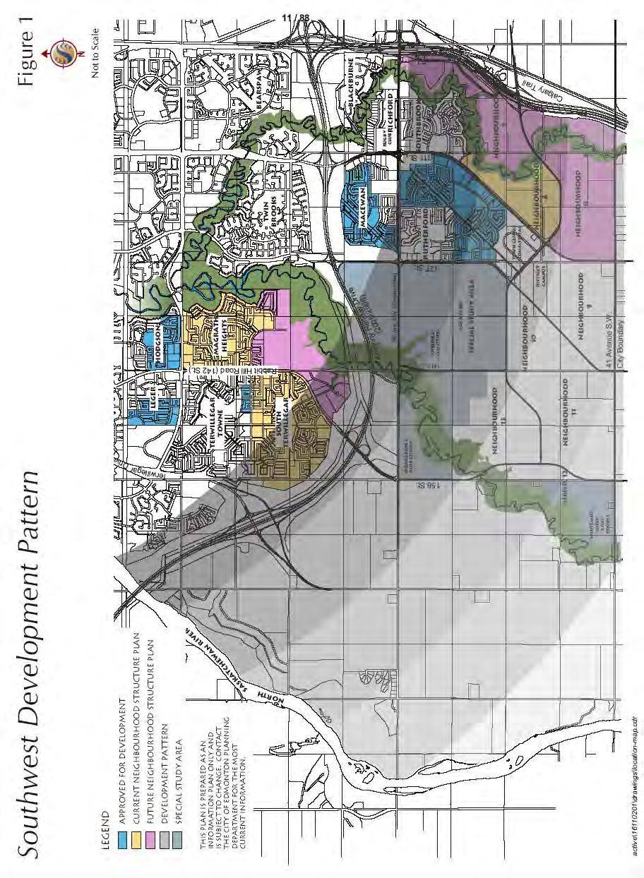
10 Since the designation of these lands as a Suburban Area, a number of key planning, transportation and development factors have influenced the need to prepare a strategic plan for the development of lands in southwest Edmonton. A summary of these key factors are briefly discussed below: 1. The construction and scheduled completion of the Southwest leg of Anthony Henday Drive by The implication of Anthony Henday Drive as an economic catalyst for Edmonton, and in particular southwest Edmonton through which it passes, is far reaching. Construction of the bridge across the North Saskatchewan River and the 170 Street/Anthony Henday Drive intersections provide excellent access to new commercial trade areas west and north of Windermere, and the opportunity to provide services omitted from the southwest sector of Edmonton. 2. Strong urban growth in Southwest Edmonton Strong economic growth in Edmonton in the last several years has translated into exceptional growth opportunities in population, employment income and urban growth in southwest Edmonton. Population forecast supplied by City Departments predicts that the City will rise by 26% from 657,511 in 2000 to 827,612 in Growth is expected to occur in all quadrants of the City with the majority occurring in suburban areas such as Windermere. During this period, suburban areas are projected to grow by 49% with some of the largest population increases expected to occur in the Southwest. It is expected that demand for single family, duplex, multi-family and higher density housing will grow in relation to the rise in population forecasted for southwest Edmonton. The southwest sector, because of its desirability, has seen the highest level of urban growth in the City compared to other parts. Analysis suggests that remaining lands within Terwillegar will be significantly absorbed within 6 to 10 years based on the demand experienced in the southwest area over the past 5 years (see Figure 1.0 Southwest Development Pattern). If new neighbourhoods (i.e. housing opportunities) are not timed to be available to meet this need, demand may shift to adjacent or outlying areas. This may include other neighbourhoods, sectors of the City or nearby municipalities. 2
11 3

12 Based on conservative modelling, employment is expected to grow by 33% to 471,000 by 2025, with approximately one-third of new jobs locating within Edmonton s suburban areas. As the economy continues to grow, demand for housing in southwest Edmonton over this forecast period is also expected to increase. This growth presents the opportunity to provide both local and regional commercial and business employment opportunities within the plan in keeping with the concept of sustainable development practices. 3. The planned extension of storm, sewer, water and shallow utility service into the study area. Responding to Plan Edmonton s Planned Growth Strategy to accommodate suburban growth in an orderly, serviced manner, and in light of SW Edmonton s population, economic forecasts and land absorption rates, several departments and agencies have pro-actively began preparing strategic servicing plans for some time now. The Southwest Area Drainage Master Plan covering Windermere and the undeveloped areas west of the North Saskatchewan River has been prepared. Plans are currently underway to extend the South East Sanitary System-south west trunk- west to 170 Street by 2007, 4
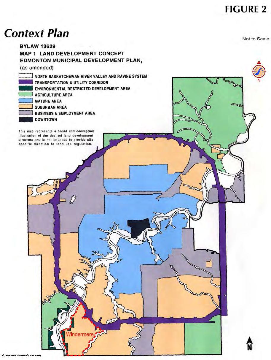
13 making it possible to bring adjacent neighbourhoods on stream for development. 4. The completion of necessary engineering, environmental and other studies required for future development of the Windermere area. In 2000, as part of the plan preparation process for the Heritage Valley SCDB, the natural areas assessment for Windermere was also done. In support of the planned development concept elaborated later on in Chapter 5, and as required by various City Departments and Agencies, a number of additional studies have been undertaken, including: A Retail Market Opportunity Assessment for the SW Edmonton Sector Transportation Impact Assessment Environmental Assessment Phase 1 for all affected landowners Geotechnical studies for areas adjacent to the River Valley and Ravine systems. These additional studies, reports and assessments represent a strong financial commitment to the growth and fiscal health of the City by the developers and property owners for long-term management of development in the suburbs. 1.4 Definition of Plan Area The Windermere Area Structure Plan includes all of Sections W4M and W4M, and portions of Sections 15, 17, 20, 22, 23, 26, 27, 28, 29, 34 and W4M. As shown on Figure 2.0 Context Plan, the Windermere ASP is defined by the following general boundaries: Northern Boundary Transportation Utilities Corridor / Anthony Henday Drive Western Boundary Top of North Saskatchewan River Ravine Eastern Boundary Whitemud Creek Ravine Bylaw December 13, 2016 Southern Boundary 41 Avenue South-West / City Limits 5
14 6
15 1.5 Land Ownership Current land ownership is shown on Figure 3.0 Land Ownership. A more detailed listing is provided on Table 1 Land Ownership in Appendix Public Consultation Process In preparation of the Windermere ASP, a series of pre-plan preparation meetings and information sessions were held with various Civic Departments, Agencies and land owners in order to identify information needs, opportunities, constraints, and overall planning approach. This included Ward Councillors, representatives from the City of Edmonton Sustainable Development, Transportation Services, Infrastructure Services, EPCOR, Edmonton Public and Separate School Boards, local landowners and the County of Leduc Planning Department. Two open house format information sessions were held on April 7, 2003 and April 23, These were attended by Ward Councillors, various landowners and residents (and or their agents). A Public Meeting was held on November 20, 2003 to provide an overview of the Plan for area residents. The meeting and scheduled information sessions provided stakeholders opportunity to voice their interest, comments, concerns and support regarding the ASP early in its preparation. The information obtained from these sessions has been incorporated into this planning document where practicable. 7

16 Bylaw 17796, December 13,

17 2.0 STATUTORY PLAN AND POLICY CONTEXT 2.1 Edmonton Municipal Development Plan The Way We Grow The Windermere ASP was approved under Plan Edmonton which was adopted by Council in In May 2010, City Council approved a new MDP titled The Way We Grow. The Way We Grow is a comprehensive plan which provides direction of development and implementation of more specific and detailed plans by the industry/private landowners and the City. Bylaw July 18, 2011 The land within the Windermere ASP is designated in The Way We Grow as Developing, Planned and Future Neighbourhoods. The Windermere ASP complies with The Way We Grow policies including, but not limited to: MDP Policy Integrate higher density development with Light Rail Transit (LRT) stations and transit centres. MDP Policy Focus land development activity and the provision of civic infrastructure to ensure developing neighbourhoods are completed from the perspective of the number of homes built in an established population threshold reached, and the civic facilities and services provided. MDP Policy Achieve a balance between residential, industrial, commercial, institutional, natural and recreational land uses in the City through land development policies and decisions. MDP Policy Acquire land necessary for City services and operations including emergency services facilities, yards, garages and storage facilities. MDP Policy Promote medium and higher density residential and employment growth around LRT stations and transit centres to support Higher density residential uses have been planned in proximity to the Transit Station in the Ambleside Neighbourhood. The Windermere ASP provides the basis and direction for the development of several complete neighbourhoods, in terms of number of homes built, an established population threshold reached, and civic facilities and services provided. The Windermere ASP provides a balance of land uses including residential, commercial, institutional, industrial, natural and recreational. The Windermere ASP designates lands for City services, such as emergency response facilities, public utilities as well as the City of Edmonton Integrated Service Yard. The Windermere ASP designates medium and high density residential as well as employment growth near Bylaw July 18, 2011 Bylaw July 18,
18 and ensure the viability of transit services. proposed transit stations. MDP Policy Support contiguous development and infrastructure in order to accommodate growth in an orderly and economical fashion. MDP Policy Ensure that public facilities are located to be accessible by a variety of modes of transportation, including public transit. MDP Policy Provide a broad and varied housing choice, incorporating housing for various demographic and income groups in all neighbourhoods. MDP Policy Ensure active transportation opportunities are included in plans and development proposals. The Windermere ASP represents contiguous growth in southwest Edmonton, as the surrounding neighbourhoods develop concurrently. The Windermere ASP designates lands for public facilities such as schools, along collector roadways which also serve as public transit routes. Pedestrian linkages through multi-use trails, walkways, and sidewalks provide access to public facilities for a variety of modes of transportation (i.e. walking, cycling, etc.). The Windermere ASP allows for the development of a variety of housing choices, including Low Density Residential (single and semi-detached), Medium Density Residential (rowhousing and low rise/medium density housing) and High Density Residential (medium to high rise units). The Windermere ASP provides a well integrated pedestrian network of multi-use trails, walkways and sidewalks to provide for a variety of modes of active transportation Plan Edmonton was adopted by City Council in 1998 and provides a framework for future land use and planning direction for the preparation of the Windermere Area Structure Plan. (Editor s note: This paragraph must be deleted with The land within the Windermere ASP is designated in the City of Edmonton s Municipal Development Plan (MDP) as Suburban Area. Numerous strategies are in the MDP regarding policies that encourage: orderly and cost-effective growth; efficient use of land and provision of services through contiguous development; provision of varied housing types and 10
19 densities; functional and aesthetically pleasing residential and business land uses; accessible recreational and open space opportunities; and, protection of the natural environment. The plan was prepared with respect to the following strategies Planned Growth Land Development Philosophy Develop and utilise a land development philosophy that meets the City s long-term development needs and achieves the optimal balance between residential, industrial, commercial, institutional and recreational land use. Strategy Provide for choices regarding the types of developments in which people want to live and do business. The Windermere ASP provides for a range of low, medium and high density residential development opportunities, employment generating business land uses and an opportunity for commercial to locate in a highly visible, accessible and growing sector of Edmonton. The ASP encourages contiguous, compact, high quality, sustainable development that will enhance community lifestyle and image in Southwest Edmonton. Strategy Address compatibility of land use in the development and review of land use plans and development proposals. The Windermere ASP proposes the integration of existing residential land uses and urban service through the application of sustainable development principles relating to Smart Growth and Future School Sites Study. Land use compatibility will be achieved through the introduction of transitional and low density housing near existing acreage communities of Windermere, Windermere Ridge and Westpoint Estates. Commercial, medium and higher density residential land uses are contemplated along Terwillegar Drive and Anthony Henday Drive forming more active and intense mixed land use nodes. In addition, careful attention to planning and design will be paid to addressing the urban interface between neighbouring residential communities developing in Terwillegar Heights and Heritage Valley, transportation facilities (i.e. Anthony Henday Drive, Terwillegar Drive, 41 Avenue SW, 184 Street, 156 Street), power right-of-way and pipeline corridors along Ellerslie Road, and plan boundaries south of the TUC, along North Saskatchewan River Valley and Whitemud Creek Ravine. Bylaw December 13,
20 Strategy Place a high priority on the effective and efficient use of land. The Windermere ASP plans for a balanced mix of business, commercial, residential, institutional and recreational land uses in an efficient land use pattern that can be economically serviced and developed on a staged basis in step with market demands. Both the ASP design and development concept support Smart Growth principles by incorporating contiguous staged growth, existing or planned infrastructure services and facilities (e.g. Anthony Henday Drive, future transit terminal), transit oriented developments, compact land use patterns, higher residential densities, diverse land uses and mobility options (i.e. walkability, transit), the mitigation of environmental impacts and provision of sustainable community benefits through new school/park concepts (proposed under Future School Sites Study and models). Strategy Plan for urban development which is environmentally friendly and fiscally sustainable in the long term, based on the City s financing, infrastructure and environmental strategies. Windermere will be encouraged to develop in as environmentally responsible manner as possible. The boundary of the ASP has been designed coincidental to that of the Whitemud Creek Ravine. Bylaw December 13, 2016 Residential densities within the ASP will be relatively high at concentrated points / activity nodes along Terwillegar Drive south of Anthony Henday Drive. This will encourage compact land use patterns, shared infrastructure and maximise overall land use efficiency. Neighbourhood parks, open spaces, pedestrian corridors and greenways have been designed to provide direct access and promote use (i.e. effectiveness). A transit terminal has been identified strategically within the northern portion of the ASP. This approach to urban development will strengthen alternative transportation options (i.e. walking, cycling, transit use) available to local residents, lessen auto dependency and demands on roadway infrastructure provision and maintenance. The Windermere ASP will incorporate necessary stormwater management facility design elements to enhance stormwater runoff quality and reduce potential environmental impacts and water treatment costs. Thoughtful design of neighbourhood stormwater facilities 12
21 will contribute to available visual and passive recreational amenities for residents. Strategy Maintain the integrity of pipelines and utility corridors while planning for growth and development. The Windermere ASP contains very few pipeline and utility corridors; these have been integrated into the plan and, where appropriate, will be integrated in the open space and walkway system Planned Growth Utilization of Existing Infrastructure Encourage maximum development around City infrastructure. Strategy Support contiguous development that is adjacent to existing development in order to accommodate growth in an orderly and economical fashion. In support of contiguous development, the Windermere ASP represents a logical extension of infrastructure in Southwest Edmonton. Completion of Anthony Henday Drive in will provide superior east-west connectivity and carrying capacity between south and west Edmonton. This major transportation facility will significantly benefit Windermere, Terwillegar Heights and Heritage Valley. Strategy Promote intensification of development around transportation corridors and employment areas. The Windermere ASP has clustered higher density residential, commercial and business land uses immediately south of Anthony Henday Drive along Terwillegar Drive and Ellerslie Road. Careful attention has been paid to locating higher density residential uses in close proximity to commercial, business, and (potential) major transit nodes along Terwillegar Drive. High and medium density residential land uses will be located in proximity to commercial services, school/park and open space amenities. Direct access to the Integrated Community Circulation System will be provided Planned Growth Preservation and Enhancement of the Natural Environment and Open Spaces Preserve and enhance the river valley, natural areas and open space within the urban landscape; recognise these 13
22 areas as critical aspects of successful planned growth of the City; and, link them to the extent possible. Strategy Develop a comprehensive, integrated plan for the river valley, natural areas and open space lands that encourages the conservation and integration of natural areas that are sustainable and feasible. The Windermere ASP borders and contains a series of environmental resources identified under the City of Edmonton Table Lands Inventory of Environmentally Sensitive and Significant Natural Areas (1993). Environmental resources bordering the ASP within the North Saskatchewan River Valley ARP include the North Saskatchewan River Ravine and Whitemud Creek Ravine systems. Bylaw December 13, 2016 Opportunities to integrate identified natural and open space areas will be provided within the Windermere ASP. Natural and open space areas will be linked via a series of integrated pedestrian, greenway, and multi-use trail and corridor connections. This will contribute to more effective open space usage, alternative transportation options, greater recreational opportunities and separation of natural areas from more intensive land uses Planned Growth Managing Suburban Growth Manage suburban growth in a manner that ensures adequate infrastructure and services and maintains a balance of residential, commercial, industrial and recreational land uses. Strategy Accommodate growth in an orderly, serviced and cost-effective manner. The Windermere ASP represents the next logical location in south Edmonton for the extension of commercial, business and residential land uses, particularly in light of the City of Edmonton s population and economic forecasts, and current rate of land absorption. Services can be extended into this area in a cost-effective manner. Under the ASP, efficient, cost effective and coordinated delivery of services will be provided. Existing water services will be extended and constructed at the cost of the developer pending detailed engineering. Stormwater will be detained onsite and discharged at predevelopment rates via a series of stormwater management facilities in accordance with the Southwest Area Drainage Master Plan. 14
23 Strategy Provide for a range of housing types and densities in each residential neighbourhood. Smart Growth encourages the provision of a variety of housing options that allow for mixed densities, types and income levels (i.e. affordable housing). Neighbourhoods in the Windermere ASP will allow for a range of low, medium and high density residential development to take place. Opportunities for a range of innovative housing types, alternative site designs and unique building sites will be encouraged that contribute to compact, affordable, pedestrian friendly development. The Windermere ASP will encourage (where feasible) innovative housing options (e.g. Grow Homes ) and development options while remaining flexible to market demands and changes in community lifecycle. This will become increasingly important as the City s economy and population continues to grow and stimulate demand for housing in Southwest Edmonton. Residential densities for neighbourhoods in Windermere are outlined in Appendix 2. More specific residential and unit densities will be established at the Neighbourhood Structure Plan stage. Strategy Encourage flexibility in creating attractive and functional residential neighbourhoods and business areas. Given the long-term nature of this Plan and the direction of development, the Plan recognises the opportunity of providing an employment node in the proximity of 170 Street, between 25 Avenue and 41 Avenue. Subject to a favourable market demand study and appropriate planning considerations, this area may be converted into a Business Employment Area. Strategy Ensure availability and access to recreational opportunities and open spaces. Through the use of environmental reserves, municipal reserves, and existing recreational opportunities, the Windermere ASP contains several open space / recreational areas including integrated stormwater management facility greenways, pedestrian linkages, opportunities for smaller passive parks and viewpoints, neighbourhood parks, community knowledge campuses, and district park campus. 15


24 2.2 Airport Protection Overlay Edmonton International Airport The Windermere ASP lies entirely outside the Edmonton International Airport Vicinity Protection Area; there is no restriction on residential development within the plan area arising from this regulation. 2.3 Suburban Neighbourhood Design Principles The City of Edmonton s Suburban Neighbourhood Design Principles (1996) report describes a series of general principles used to guide the sustainable design of suburban neighbourhoods. These principles cover infrastructure, community facilities, roadways, bicycle and pedestrian linkages, transit service, institutional and school / park sites, housing, population projection and student generation as they relate to suburban neighbourhoods in Edmonton. The Windermere ASP has been designed and planned to incorporate these principles as they relate to concepts of Smart Growth, Transit and Pedestrian Oriented Development. Subsequent Neighbourhood Structure Plans (NSPs) will incorporate the Suburban Neighbourhood Design Principles. 2.4 Environmental Policies and Practices The City of Edmonton s Inventory of Environmentally Sensitive and Significant Natural Areas (1993) identifies four Local Environmentally Sensitive Areas within the Windermere ASP (SW1, SW2, SW 40 and SW 51). Accordingly, in accordance with City Policy C-467, Conservation of Natural Sites in Edmonton s Table Lands, a Stage 2 Detailed Natural Site Assessment (NSA) must be completed for these areas prior to the approval of any neighbourhood structure plans. Phase I Environmental Site Assessments (ESA) have been prepared for portions of the Plan area, particularly areas north of Ellerslie Road. Further site assessments will be required for the remaining areas upon submission of Neighbourhood Structure Plans. For areas of the Plan that are adjacent to the North Saskatchewan River, the Whitemud Creek and other tributaries, the policies contained in the North Saskatchewan River Valley Area Development Plan, Bylaw 7188 shall apply. In accordance with regulations of the Municipal Government Act and the City s Topof-the Bank Public Roadway Policy in effect, these lands will be protected as Environmental Reserve and zoned A Metropolitan Recreation Zone in the future. 16
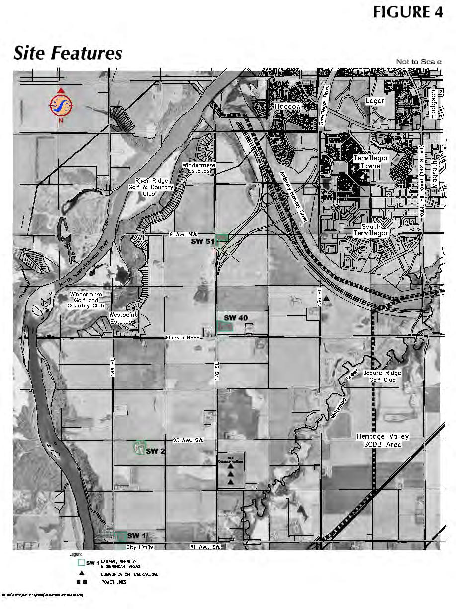
25 The stated purpose of the City of Edmonton s Top-of-Bank (TOB) Roadway Policy is twofold. The first is to ensure the provision of open space between river and ravine systems (i.e. North Saskatchewan River Valley System and Whitemud Creek Ravine) and urban development; second, is to ensure public access to river and ravine systems is provided. As shown on Figure 4.0 Site Features, it is proposed that urban development backing onto ravine systems be setback from the TOB by a 7.5 m open space pending geotechnical investigation. Opportunity exists to integrate viewpoints within the ASP that are accessible via open space system and roadway circulation. The need for scenic routes and alignment for Top of the Bank roads or walkways will be determined at the neighbourhood plan stage pending analysis of required geo-technical studies. 17
26 18
27 2.5 Smart Choices (Smart Growth) The Smart Choices for Developing Our Community Recommendations was approved by City Council on March 23, These principles incorporate a number of smart growth ideas from the Smart Choice Catalogue of Ideas that has recently been prepared by the City of Edmonton. Smart Growth refers to the comprehensive planning, design and development of communities to encourage community sense of place, preservation and enhancement of natural and cultural resources, equitable distribution of development costs and benefits, an expanded range of employment, housing and transportation choices that are fiscally responsible. The Windermere ASP utilises Smart Growth principles to foster mixed use developments, contiguous urban development, the efficient use of infrastructure and services, alternative transportation modes, and employing environmental design in building communities. Of the nine ideas presented in this document, three are relevant to new suburban development and are applicable to Windermere. The following Smart Choices approach are supported and form the underlying structure of the Windermere ASP. Transit Oriented Development (TOD) encourages the comprehensive planning, design and development of pedestrian friendly environments built within easy walking distance of a transit station. The development concept for Windermere focuses higher density development around transit facilities and commercial / employment nodes, dispersing lower densities progressively outward. The intent is to encourage a range of land uses that support affordable housing choices, local employment opportunities, commercial / retail services and amenities, and alternative transportation options that are integrated and mutually self-supporting. Mixed Use Node / Development encourages the integration and mix of higher intensity land uses at strategic transportation focal points (e.g. major roadway intersections). The framework of the Windermere ASP is designed to encourage compact development patterns, sharing of common infrastructure, services and facilities, effective land use transitioning, and development of local synergies (e.g. vibrant local economy, social activity, supportive community). The mixed-use development will provide a range of affordable housing options, commercial services and amenities, transportation modes, employment opportunities, entertainment, culture and attractive urban settings conducive to the creation of healthy, vibrant and sustainable urban communities. 19
28 Multi-Use Trail Corridors and Mixed Use Development refers to the use of abandoned rail corridors and utility rights of way by pedestrians and cyclists. This form of urban space offers considerable opportunity to provide enhanced access within a community that is safe, convenient and attractive. The Windermere ASP encourages the use of existing utility corridors where feasible within the plan area to link into the regional system. As illustrated in the Open Space Plan, corridors and / or connections are established to link with the North Saskatchewan River Valley and Whitemud Creek Ravine systems, TUC, major pipeline utility rights of way. 20


 are located along the top of bank of the North Saskatchewan River Ravine.")

29 3.0 SITE CONTEXT AND DEVELOPMENT CONSIDERATIONS 3.1 Existing Land Uses The land uses within the study area are dominated by agricultural activities with large residential estates, country residences, and recreational facilities concentrated to the northwest along the North Saskatchewan River Valley. Electrical transmission towers traverse the study area south at approximately 149 Street and along the northwest within the TUC. The Windermere ASP contains a number of existing land uses as shown on Figure 5.0 Opportunities and Constraints. In general, agricultural uses dominate the plan area and include grain crops, hayfields, pastured land and small country residences. In the north-western portion of the ASP, large residential estates (i.e. Windermere, Windermere Ridge and Westpoint Estates) are located along the top of bank of the North Saskatchewan River Ravine. Major recreational sites such as River Ridge and Windermere Golf and Country Club(s) are located along the North Saskatchewan River Valley. In the eastern portion of the plan, the Jagare Ridge golf club is located at the eastern boundary of the ASP directly south of Ellerslie Road and west of the Whitemud Creek Ravine. This recreational area is bisected by electrical transmission towers traversing north-south across the plan area at approximately 149 Street. Slightly west of the electrical transmission lines on lands owned by the City of Edmonton a snow dump exists on the north side of Ellerslie Road. A private corporation s micro -cell tower is located north of Ellerslie Road along 156 Street. Amended by Editor In the southern portion of the ASP, three Canadian Broadcasting Corporation communication aerials are located in the NW1/4 of Section W4M. 21

30 Bylaw 17796, December 13,


31 The remainder of the lands are cleared and under cultivation. None of these uses pose any particular constraints to future urban development. However, future development of any and all properties within the study area is the option of the respective landowners. 3.2 Surrounding Land Uses The ASP area is bound by Anthony Henday Drive on the north, east by Whitemud Creek, south by 41 Avenue SW and North Saskatchewan River Ravine Top-of-Bank on the west. The surrounding land use north of Anthony Henday Drive is the developing residential neighbourhoods of Haddow and Terwillegar Towne and planned neighbourhoods of Terwillegar Gardens and South Terwillegar. East of Whitemud Creek future neighbourhoods within Heritage Valley are contemplated. South of 41 Avenue SW lies the Intermunicipal Fringe composed primarily of cultivated agricultural land and farm residences. West of the Top-of-Bank lies the North Saskatchewan River Ravine System, Windermere and River Ridge Golf and Country Clubs. Directly south of the Windermere ASP is agricultural land located within the Leduc County / Edmonton Intermunicipal Fringe Area. This area of Leduc County has been experiencing increasing development pressure prompting the County to commission an Area Structure Plan for these lands. In January of 2003, terms of reference were established for the Leduc County North Area Structure Plan which includes a portion of north-east Leduc County and those lands located near / adjacent to the City of Edmonton (that includes Windermere), Nisku Business Park, Town of Beaumont, and Strathcona County. The Leduc County North Area Structure Plan will identify key land use issues, opportunities and constraints, engage and consult with relevant stakeholders, and develop a Preferred Planning Concept. The intent is to establish planning goals, objectives, and policies that will guide future planning and development for the area over the next 20 years. This document should be consulted regarding future urban development interface within the Leduc County / Edmonton Intermunicipal Fringe Area. 23
32 3.3 Topography, Soils and Hydrology The Windermere landscape is level to slightly undulating with gentle sloping, downward, to the north-east. The highest elevation point is 701m located east of 184 Street north of 41 Avenue SW (see Figure 5.0). Steep inclinations scored into the tablelands by the North Saskatchewan River and Whitemud Creek ravine bound the study area to the west and east respectively. Soils within the Windermere Area are generally silty loam. As such, the soil conditions do not pose any impediment to urban development. Small low-lying depressions are located near the North Saskatchewan River and Whitemud Creek ravine systems. Water retention in these areas is seasonal with more established depressions retaining water throughout the year. Formalised drainage channels are generally not apparent. 3.4 Environmental Resources The City of Edmonton Table Lands Inventory of Environmentally Sensitive and Significant Natural Areas (1993) identifies a series of prominent environment resources within the Windermere area. As shown on Figure 5.0, these include North Saskatchewan River Valley, Whitemud Creek, 41 Avenue SW 184 Street SW Woodland (SW1), Southwest Wetland (SW2), and two forested natural areas (SW40 and SW51). Characteristics of these environmental resources are further documented by Westworth Associates Environmental Ltd. for the City of Edmonton Sustainable Development under a by a Stage One Preliminary Natural Site Assessment entitled A Conservation-Based Approach to Urban Development in the Heritage Valley Area (2000). The basic purpose of a Stage One Preliminary NSA is to screen the natural site to identify important environmental issues and implications for development. Descriptions of these sites follow below North Saskatchewan River Valley and Associated Ravines The North Saskatchewan River Valley borders the west boundary of the Windermere ASP and spans over 200 hectares between the TUC and 41 Avenue SW. The area within the river valley is relatively flat and composed of discontinuous lengths of floodplains and terraces (see Figure 5.0). Relatively large undisturbed forest composed of aspen, balsam poplar and birch support a wide diversity of plant species contributing to this site's self-sustainability. Furthermore, a well-developed understory 24
33 provides critical wildlife habitat and movement corridor linking local significant natural areas and table lands in south-west Edmonton. Given the river valley s history as a travel corridor, the archaeological potential for this area is high. In addition, six coal mines are identified as historic sites within the North Saskatchewan River Valley ravine system. Surrounding area land uses include Windermere and River Ridge golf courses, a few country residences, and residential developments of Windermere, Windermere Ridge and Westpoint Estates Whitemud Creek Ravine This environmental resource is located outside and adjacent to the east boundary of the Windermere ASP. This area is set within a ravine with which contains a number of terrace areas (plateaus). Portions of the ravine system support a wide variety of plant communities providing a diversity of habitat for local bird species and larger mammalian wildlife (e.g. deer, coyotes). Similar to the North Saskatchewan River Valley, this area provides an important wildlife corridor to interior table lands. Bylaw December 13, 2016 The potential for historical resources is high within the Whitemud Creek area given the history of coal mining in the area. Four coal mines are identified along the Whitemud Creek Ravine system. The current physical condition of these mine locations has not been evaluated. The predominant surrounding land use is agricultural (e.g. grain crops and pasture) with Jagare Ridge Golf Course bordering a portion of these lands along the east boundary of the plan area Significant Natural Area: 41 Avenue SW 184 Street SW Woodland (SW1) This identified environmental resource is classified as a significant natural area and encompasses 2.14 hectares in the southwest portion (SW ¼ Section W4M) of the ASP. The woodland area is bound by 184 Street to the west, grain crops to the north and east portion of the site, and 41 Avenue SW to the south (see Figure 5.0). This site is characterized by undisturbed old-growth balsam poplar aspen forest uncommon to this area with welldeveloped and diverse shrub understory providing supporting habitat for wildlife commonly found in Edmonton. This site provides an important supporting linkage between upland habitats and river valley. No observations of historical resources were made at the time of the preliminary site assessment although due to this site s proximity to the North Saskatchewan River and ravine system, a moderate potential for archaeological or historical resources exists. 25
34 3.4.4 Environmentally Sensitive Area: Southwest Wetland (SW2) This wetland area is listed as a local environmentally sensitive area in southwest Windermere (1.5 km north of 41 Avenue SW on the east side of 184 Street, NW ¼ Section W4M). The site is approximately 3.25 hectares in size and is subject to cycles of wet and dry conditions. Vegetation is comprised of extensive beds of sedge centrally with willow largely bordering the periphery. This site is used extensively by deer and to a lesser extent by moose as forage and cover. This site provides ecological linkages between river valley and upland areas and is considered marginally sustainable. No historical resources were observed and this site is considered to have low potential given its poorly drained soils. This environmental resource contributes to the balance of local hydrology and is considered to be ecologically viable. Further study to integrate this wetland will be pursued at the neighbourhood development stage Natural Areas The Windermere area is predominantly agricultural land with the exception of existing residential and recreational land uses. Hedges and windbreaks line a considerable portion of cultivated land and roadway network with the North Saskatchewan River and Whitemud Creek Ravine systems bordering the study area to the west and east respectively. Natural areas present within Windermere are identified by the City of Edmonton Table Lands Inventory of Environmentally Sensitive and Significant Natural Areas (1993), and A Conservation-Based Approach to Urban Development in the Heritage Valley Area (2000). These documents, in conjunction with Development Setbacks from River Valley/Ravine Crests (2002), provide additional information regarding potential environmental resources in Windermere. A short description of natural areas within the ASP follows. Natural Area: 170 Street Immature/Mature Balsam Aspen Poplar Forest (SW 40) The Inventory identifies approximately 4.0 hectares of woodlot within the southwest area of Neighbourhood One (see Figure 5.0) as a natural area. This area is composed of a relatively open balsam aspen forest of immature and mature trees. No significant changes were apparent on the Site in terms of human developments or successional changes. The SW 40 natural area has no significant environmental elements and is judged to have a low environmental sensitivity with moderate conservation priority (Westworth Associates Environmental, 2000). As 26
35 such, consideration should be given to retention of a portion of this area where feasible. Natural Area: Mature Aspen Poplar Forest (SW51) This natural area is surrounded by hay land and is located to the southeast of Windermere Boulevard and 170 Street (NW ¼ Section W4M) within the ASP. This area comprises approximately 2.0 hectares of mainly undisturbed mature aspen forest. Shrub and herbaceous understory are well developed and, with a number of snags and some downfall, contribute to a relatively diverse assemblage of bird species. Evidence of deer and coyote browsing was identified. This area has a moderate potential for historical resources (although none were identified during reconnaissance) given this areas relatively flat and well-drained land. It is suggested that consideration be given to retaining portions of this area and that appropriate studies be conducted at the NSP stage. 3.5 Environmental Site Assessments Descriptions of Environmental Site Assessments conducted on lands within the ASP are provided following Table 2 Windermere ASP Environmental Site Assessments. TABLE 2 WINDERMERE ASP ENVIRONMENTAL SITE ASSESSMENTS Location Phase 1 Phase 2 Comments Ptn. South ½ of Section W4M North ½ of Section W4M Yes No No further investigation required at this time Ptn. NW ¼ Section W4M Yes Yes No further investigation required at this time Phase I ESA Ptn. South ½ of Section W4M, North ½ of Section W4M A Phase I Environmental Site Assessment (ESA) has been undertaken for those lands located east of 170 Street and north of 9 Avenue SW. The property is legally described as 27
36 portions of the south half of Section W4M and the north half of Section W4M. These lands have been used primarily for agricultural purposes. This report has been submitted under separate cover. Based on the findings and recommendations of the Phase I ESA, no areas of immediate environmental concern were identified on or in the vicinity of the Subject Property Phase II ESA Ptn. South ½ of Section W4M A Phase II Environmental Site Assessment (ESA) was conducted by CT & Associates Engineering Inc. for the property located at the north-east corner of the intersection of 170 Street and existing Ellerslie Road. This property is legally described as the south half, SW ¼ Section W4M (excepting thereout a 2.42 hectare property located along the south boundary of the site). This report has been submitted under separate cover. Bylaw July 18, 2011 The Phase I portion of the assessment included a review of historical records and site reconnaissance of the subject site and surrounding areas to provide information pertaining to previous and current operations on the subject property and surrounding areas which may be of environmental concern. The results of the Phase I ESA portion identified a former oil well (drilled and abandoned) within the east half of the subject site. No other evidence of environmental or other potential sources of contamination (via waste management practice(s) or current operations) were identified. Following identification of a former oil well within the subject property, a Phase II ESA was conducted to confirm the subsurface soil conditions in the vicinity of the abandoned oil well. No evidence of impact on subsurface soil conditions was found. Based on findings and recommendations of the Phase II ESA, the subject site meets required CCME Residential Land Use Criteria and no further investigation is required at this time Non-Participating Land Owners No other Phase I or II Environmental Site Assessments have been undertaken on the remaining lands within the Windermere ASP. In light of this, the Environmental Planning Group of the Sustainable Development typically recommend that ESAs or disclosure statements be provided by the minority land owners at the rezoning stage. 28
37 3.6 Heritage Resources Assessment of Heritage Resources within the ASP are provided in Table 3 Windermere ASP Historical Resources Overview / Impact Assessments followed by further description. TABLE 3 WINDERMERE ASP HISTORICAL RESOURCES OVERVIEW / IMPACT ASSESSMENTS Location HRO HRIA Comments NW 1/4 of Section W4M Ptn. NE 1/4 of Section W4M, NE 1/4 of Section W4M, Yes No No further investigation required at this time Ptn. NW 1/4 of Section W4M Known Archaeological and Historic Sites No archaeological sites have been recorded within the Windermere ASP area (Westworth Associates Environmental, 2000). It is anticipated that further archaeological study will be required along, above and within high potential locations such as Whitemud Creek and North Saskatchewan River Valley ravine systems. Historically, agriculture and coal mining have been the primary economic activities within the Windermere area. Consequently, three coal mines, a schoolhouse and prison lands are identified as historic resources within the Windermere ASP. Prior to neighbourhood plan approval, Historical Resources Overview(s) (HRO) must be completed. Geotechnical studies will be required for lands adjacent to the North Saskatchewan River Valley and Ravine System prior to the subdivision stage of development, and top-of-bank roadways will be implemented in accordance with the Topof-Bank Policy Two coal mines are identified within Neighbourhood Four within the ASP. The first coal mine (#1628 operated by Blue Pointe Mine from 1944 to 1954), is located along the eastern boundary of the neighbourhood (NE ¼ Section W4M). The second, mine (#1204 operated by J.D. McMillian from 1925 to 1928) is located in the south portion 29
38 of the neighbourhood (SW ¼ Section W4M). A third coal mine is identified within Neighbourhood Three of the ASP. Coal mine #838 was operated by Falvo Mine A from and is located north of Natural area SW2 (SW ¼ Section W4M). According to the South Edmonton Papaschase Historical Society (1984), an historic school site is located in Neighbourhood Four of the Windermere ASP. This site is identified as Whitemud School (still retaining its original log structure) and reportedly relocated to a portion of NW ¼ Section W4M in Located in Neighbourhood Two in Section W4M a prison farm was operated by the City of Edmonton from 1913 to As of 1983, two cement buildings remained along Windermere Drive Historical Resources Overview Ptn. Sections 27 & W4M A Historical Resources Overview (HRO) was conducted by Stantec Consulting Ltd. for portions of lands legally described as the north half of Section W4M and north half of Section W4M. This report has been submitted under separate cover. These lands have been used primarily for agricultural purposes. Based on the findings and recommendations of the HRO, it is anticipated that suburban development will not impact any significant historical resources and that no further investigation is required at this time. 3.7 Energy and Natural Resources Oil and gas activity in Windermere remains significantly limited reflecting the relatively small size and productivity of oil and gas reserves in the area. A history of dry and abandoned oil and gas wells located in south and southwest Windermere (as shown on Figure 5.0) characterise this area s limited potential for resource extraction. In accordance with the City of Edmonton policies, adoption of the ASP will provide clear direction for the development of lands within Windermere and discourage further oil and gas exploration Non-Producing Oil and Gas Well Sites No actively producing oil or gas wells are located within the plan area or recently licensed within the ASP. As shown on Figure 5.0, there are 14 dry and abandoned wells, 2 30
39 abandoned oil wells and one non-producing gas well located within the Windermere ASP. A description of sites within the ASP is provided in Table 4 Windermere ASP Non-Producing Oil and Gas Well Sites. During the NSP stage, these sites will require identification and confirmation that they have been suitably abandoned and decommissioned for future urban development. TABLE 4 WINDERMERE ASP NON-PRODUCING OIL AND GAS WELL SITES Location Substance Status NE ¼ Section W4M Oil Abandoned NW ¼ Section W4M Natural Gas Dry and Abandoned NE ¼ Section W4M (2 well sites) SE ¼ Section W4M (3 well sites) Natural Gas Natural Gas Dry and Abandoned Dry and Abandoned NE ¼ Section W4M Natural Gas Dry and Abandoned NW ¼ Section W4M (2 well sites) Natural Gas Dry and Abandoned NE ¼ Section W4M Natural Gas Dry and Abandoned NE ¼ Section W4M Natural Gas Held by Production NW ¼ Section W4M Natural Gas Dry and Abandoned SE ¼ Section W4M Natural Gas Dry and Abandoned SW ¼ Section W4M Oil Abandoned SW ¼ Section W4M Natural Gas Dry and Abandoned SE ¼ Section W4M Natural Gas Dry and Abandoned Pipeline Rights-of-Way and Facilities A review of information provided by the Alberta Energy & Utilities Board (AEUB) has indicated that three pipeline transmission facilities are located within the ASP study area (see Figure 5.0). The first pipeline right-of-way (7231) consists of a high pressure gas line originating at a regulating station located centrally within the plan area at existing Ellerslie Road and 170 Street. This pipeline travels north along the east side of Terwillegar Drive until turning eastward around a small parcel of land located in the NW ¼ of Section W4M. This pipeline exits the plan area east terminating at a regulating station at the tip of LSD 4 in the SW ¼ of Section W4M. Bylaw July 18,
40 Transecting the ASP are two distribution pipelines that form an east-west pipeline corridor immediately adjacent to existing Ellerslie Road. These pipelines run parallel with each other entering the study boundary from the east along the north side of Ellerslie Road. At 156 Street, pipeline crosses south continuing parallel with pipeline on the north side of Ellerslie Road. Both pipelines and exit the western boundary of the ASP. Bylaw July 18, 2011 The Alberta Energy and Utilities Board Pipeline License Register identifies these pipeline transmission licenses within the Windermere ASP boundary (summarised on Table 5 Existing Pipeline Transmission Facilities). Since these pipeline corridors travel the northeast and central east-west portions of the Windermere ASP, any future development will have to be integrated. TABLE 5 (as amended by Editor) WINDERMERE ASP EXISTING PIPELINE TRANSMISSION FACILITIES Company Substance H 2 S Content (mol/kmol) 1 Max. Operating Pressure (kpa) 2 Max. Outside Diameter (mm) 3 Private Corporation (7231) Private Corporation (37844) Private Corporation (15440) Natural Gas Natural Gas Natural Gas ,200 6,070 6, sour natural gas occurs when the H 2 S content is greater than 10.0 mol/kmol 2 a high pressure line has a maximum operating pressure greater than or equal to 3,475 kpa 3 a high pressure line has an outside diameter greater than or equal to mm The City of Edmonton s Policy Guidelines for the Integration of Transmission Pipelines and Urban Development (1985) and any other relevant Provincial legislation will be employed when considering rezoning and subdivision applications near or adjacent to the above noted pipelines. There are no sour gas wells in the study area. 32

41 4.0 DEVELOPMENT GOALS, OBJECTIVES & PRINCIPLES The vibrancy and health of a new community rests in its relationship to the surrounding region as well as the diverse opportunities it affords its residents throughout their daily lives and stages of life. Accordingly, the Windermere ASP recognises the need for development that is sustainable within an Edmonton context that meets the needs of the present without compromising the ability of future generations to meet their own needs (United Nations Brundtland Commission, 1987). The Windermere ASP therefore embraces a new way of thinking about Southwest Edmonton, one that focuses on the long-term synergistic interconnections between economic, social and environmental systems to develop a sustainable community. 4.1 Goals The Windermere Area Structure Plan (ASP) seeks to establish a vibrant and sustainable community in southwest Edmonton where people choose to live, learn, work, and play throughout their life. Surrounded by the North Saskatchewan River, Anthony Henday Drive and Whitemud Creek Ravine, Windermere will nurture such a community through a diversity of planning approaches and the careful integration of the natural and built environment. 4.2 Development Objectives The Windermere ASP has been comprehensively planned taking advantage of the natural topography, existing major transportation corridors, utility and pipeline corridors, and locational attributes of the area. The main objectives of the ASP are as follows: To develop a plan consistent with the general intent and purpose of the City of Edmonton Municipal Development Plan. To provide a framework to deliver a high quality, comprehensively planned community by defining the general pattern and composition of land uses and activities, access, linkages, servicing designs and development staging. To address and accommodate existing uses (i.e. other property and existing residential development) within the plan. 33
42 To ensure implementation of the ASP on an orderly staged basis. A long-term commitment to the implementation of the Windermere ASP is necessary in order to ensure that the overall vision, development concept and objectives are met within a framework of sustainable development. The following development principles have been established to assist in achieving those objectives. 4.3 Development Principles The following statements have been established as key principles for the design and development of the Windermere area. These guiding principles and concepts, as illustrated on the Framework Plan (at the end of Section 4) will be used to guide the preparation and subsequent development of future neighbourhood plans. These principles incorporate a number of Smart Growth ideas from the Smart Choice Catalogue of Ideas recently approved by the City of Edmonton. The following Smart Growth ideas have been incorporated into key principles supported under the Windermere ASP: Innovative and compact neighbourhood design Life long learning and local employment opportunities Mixed Use and Transit Oriented Development A range of housing choices for a variety of income levels A range of transportation options including greenways and corridor connections Pedestrian friendly neighbourhoods Efficient, contiguous and staged urban infrastructure Preservation and enhancement of natural areas and open spaces Community Design and Enhancement Significant opportunity exists to further assert Edmonton s Suburban Neighbourhood Design Principles at the local community level. This is particularly relevant to creating and maintaining neighbourhoods and communities that are sustainable. Community enhancements represent a unique approach to increasing the value of communities through a series of negotiated trade-offs between municipality and developer(s). 34
43 Community enhancements refer not only to buildings, and their interface to the streets / squares, but to the design, development and or servicing of special landscape features that add value and meaning to neighbourhoods and communities. These may include: Establish a unique character and sense of place for each neighbourhood. Provide unique entrances or gateways, landscaped transportation corridors, identifiable streetscapes, distinctive neighbourhood boundaries and districts, innovative natural and open spaces, landmarks and / or focal points within a community. These elements, patterns and connections will continue to evolve over time as the community (re)creates its own authentic image, character and sense of place. Ensure that each neighbourhood is designed with a focal point. A neighbourhood centre, park or school that offers a range of convenience commercial uses, services and/or amenities can function as a gathering place for neighbourhood residents. The focal point should be activity oriented and combine uses and services that draw people to the area. Design for an attractive environment. High quality building design and streetscaping enhance local urban design. A variety of urban spaces, landscaped areas and architecturally designed features contributes to a rich human scale living environment. The Windermere ASP encourages high quality urban design in concert with Transit Oriented Design, pedestrian environments and Mixed Use Nodes that support attractive, innovative building design and street amenities. Urban design / Crime Prevention Through Environmental Design (CPTED) features (e.g. consideration of enhanced shelters, strategic lighting, wayfinding features, viewpoints, universal design devices) Sustainable Local Employment Area(s) Commerce and business provides local employment opportunities and broadens the base of the local economy. Jobs within a community also contribute to its sustainability and residents quality of life, while reducing traffic levels and the environmental costs associated with commuting long distances. The ASP has been designed to support a wide range of commercial and retail businesses, as well as office, professional and other local employment uses that support the local and surrounding areas. The following principles support employment opportunities in Windermere: 35
44 Designate business areas in location with well-linked transportation connections and good visibility to strengthen their vitality. Place employment centres along major transportation corridors, and integrate complementary uses in the vicinity such as housing options, entertainment and transit facilities that help link the community together. Locate a transit centre in the principal commercial area(s) to provide linkages throughout the community. Develop commercial and mixed-use areas that are safe, comfortable and attractive to pedestrians Mixed Use, Transit Oriented Development Mixed Use and Transit Oriented Development (TOD) is an important planning concept. Combined, this form of development is defined as, a mixed use residential and commercial area designed to maximise use of transit and non-motorised transportation, and are commonly referred to as transit villages. The Windermere ASP incorporates this type of development by providing opportunities for: Comprehensive planning, design and development of pedestrian friendly environments built within easy walking distance of a transit station. Higher density development around a central transit facility dispersing lower densities progressively outward. A range of land uses that support local employment opportunities, commercial / retail services and amenities, and alternative transportation options that are integrated and mutually self-supporting. Mixed Use Nodes / Development that provides a range of affordable housing options, commercial services and amenities, transportation modes, employment opportunities, entertainment, culture and attractive urban settings. A complete community concept based on a harmonious range of mixed uses within easy walking distance. The Windermere ASP includes higher residential densities at strategic transportation nodes served by commercial, retail, business employment, entertainment and open space opportunities and transit service(s). 36
45 Strategic placement, design and development of transit facilities having regard for the surrounding area. The ASP encourages placement of transit facilities within 400 m walking distance of residential areas that includes a range of housing types and income levels Balanced Transportation Network Providing future Windermere residents with a choice of travel modes is a key component of the Plan. Smart Choices identifies walkability as a key component in the promotion of sustainable compact development. Successful incorporation of community walkability requires, high building and population density, mixed land use, a quality public transportation system, and high-quality public spaces. Walkable communities bring a number of benefits including alternative transportation options and pedestrian routes, better personal health and economic cost savings, improved sense of community and perception of safety in public, greater public transit use, cleaner environment, reduces urban sprawl, and enhanced service and amenity accessibility. The following principles support a balanced transportation system in Windermere: Provide a transportation network that reflects the character of intended developments and meets the unique demands of each neighbourhood, as well as the City s wider transportation objectives. Provide a logical, safe and efficient transportation system within the plan area to address the pedestrian, bicycle and vehicular transportation needs of residents moving to, from and within the Windermere area. Provide opportunity to initiate transit service early in development. Explore opportunities to partner with the City of Edmonton on the development of transit facilities (e.g. Transit Centre / Station; attractive stops and comfortable waiting areas). Plan for the provision of transit service within 400 m of residential areas that include a range of housing densities, types and choices. Provide an attractive pedestrian environment connected by streets with a high degree of connectivity. The ASP design conceives an Integrated Community Circulation System composed of parks, greenways, and multi-use trails that support pedestrian 37
46 connectivity, options, and movement throughout the community. Establish an Integrated Community Circulation System of parks, greenways, Multi-Use Corridor Trails and or connections that encourages pedestrian connectivity, activity and social contact. Integrate existing transportation, utility and pipeline corridors into the ASP making use of potential greenways and pedestrian linkages while having regard for the safe, ongoing operation of these transmission facilities. Provide Multi-Use Trail Corridors and connections that include the North Saskatchewan River Valley and Whitemud Creek Ravine systems, Transportation / Utility Corridor, major pipeline utility rights of way Life Long Learning and Education The Windermere ASP recognises the vision and model set out under the Future School Sites Study. This study has been initiated in response to longstanding vacant school sites in Edmonton and increasing concern over the provision of schools in newly developing neighbourhoods. The intent is to enhance the overall effectiveness of school site delivery and service provided to existing and future residents. Through multi-stakeholder collaboration, a new vision and model of school delivery in Edmonton was reached. The vision for future schools sites in Edmonton states: School sites in communities of the future will be centrally located, multi-use community knowledge campuses that serve students and learners of all ages and house a range of complementary recreational, community and public services. They will be beacons at the heart of the community that are relevant, adaptive, flexible and accessible. The Windermere ASP strategically locates a series of Neighbourhood Parks and Community Knowledge Campus (CKC) sites throughout the plan area along with a District Park Campus centrally within the plan. These areas are further integrated with an overall open space system composed of natural areas, greenways and open spaces. The location of Neighbourhood Parks, CKCs and District Park Campus have been planned to: Allow for early servicing in the development of neighbourhoods and maximal coverage within the broader community catchment area. 38
47 Provide flexible site and facility design to accommodate a full range of life-long learning and recreational needs within the community. Encourage sharing of common infrastructure. Opportunities to enhance the place-making role of freestanding school / park sites and facilities as community focal points within the ASP will be additionally explored. Allow for localised / disbursed park sites at the subneighbourhood level (e.g. tot lot, parkette, common green / garden, view point) that add to available recreation and open space opportunities. Provide opportunity for public services via Public Private Partnerships (P3s) or municipal lease option (e.g. Emergency Medical Services; Fire and or Police Station, Public Library) Sustainable Infrastructure The Windermere ASP will promote sustainable infrastructure that is efficient, affordable and innovative as an integral component of servicing the community. The provision of infrastructure within the Windermere area aims to: Encourage extension of services into the Windermere area in a co-ordinated, efficient and cost-effective manner. Encourage compact land use patterns and shared infrastructure that optimise land use and building efficiency. Incorporate necessary stormwater management facility design elements to enhance stormwater runoff quality, mitigate potential environmental impacts and reduce water treatment costs. Integrate pipeline and utility corridors within the plan and, where appropriate, integrate corridors with pedestrian linkages, greenways, multi-use trails / corridors, and open space areas Preservation and Enhancement of the Environment Windermere will be encouraged to develop in as environmentally responsible a manner as possible. The following principles support the preservation and enhancement of the natural environment: 39
48 Preserve and enhance its environmental resources. Windermere will continue to preserve and enhance its environmental resources for the benefit of future residents. Protect and enhance significant natural features of the community when designing and planning facilities and services. Natural features such as riparian areas, old growth forests, and identified significant / sensitive environmental areas should be protected and enhanced for their biological and scenic / aesthetic values. Incorporate existing natural features in the design of neighbourhoods. Planning with nature rather than against it saves money, energy, materials, maintenance requirements and enhances site amenities. Incorporating natural drainage patterns into new developments results in continued natural drainage and less demand for extensive storm sewer systems. Planning with existing views / vistas and minimising the amount of vegetation cleared during initial construction adds to the aesthetic quality of an area. Where feasible, use natural features such as drainage courses to provide linkages between and within neighbourhoods. Natural areas should be used as linkages within the plan area. Integration of these natural features to accommodate bikeways and pedestrian linkages from housing to the school, or to focal points within the community will reinforce the need to protect natural areas. 40

49 Windermere Preliminary Conceptual Framework 41
50 5. 0 DEVELOPMENT CONCEPT 5.1 Land Use Concept The Windermere ASP is designed using a number of planning principles and best practices to evolve the proposed land use concept. The concept reflects the influences of the river valley systems and the location opportunities provided by the freeways and arterials, in particular 170 Street that forms a north/south central spine in the community. The design principle is based on a series of nodes at intersecting arterials that provide the opportunity for Transit Oriented Developments, where higher density housing will radiate to lower densities surrounding the nodes and corridors. Using five neighbourhoods as the basic organizing principle to deliver planning services (see Figure 6.0 Neighbourhood Units), the Plan provides for a mix of business, employment and higher density residential uses in a pattern intended to support higher transit use and provide balanced mixed use developments. The proposed plan is anchored by a sectoral retail centre / business employment area located immediately south of Anthony Henday Drive, east of 170 Street west of 156 Street and by a hierarchical system of roadways and pedestrian linkages, trails and open spaces. This major activity node is anticipated to serve the residents of Windermere as well as the southwest Edmonton sector, and will be designed to incorporate a mix of community uses including civic, economic, transportation and social functions. The area is proposed to contain public parks and squares, pedestrian friendly streets and a broad mix of supported activities including shopping, entertainment, working and living. The total plan area is approximately 1,775 hectares. The area, number of dwelling units, and population attributed to each form of development is shown in section 9.0 appendices. The distribution of these uses is illustrated in Figure 7.0 Development Concept. Bylaw July 4, 2011 Bylaw December 13, 2016 The Windermere ASP has been prepared recognising a number of planning concepts that include Smart Growth and Transit Oriented Development. As such, the plan encourages a mix of business, employment and higher density residential uses in a pattern intended to support 42

51 Bylaw 17796, December 13,

52 Bylaw 18280, January 22,
53 higher transit use and provide balanced mixed-use developments. Neighbourhoods will be designed as distinct, compact pedestrian friendly communities with focal points that create a sense of place. The location of environmental and municipal reserve, the layout of the roads and the recommended location of major infrastructure and multifamily land uses have been designed to protect the ravines, old growth forests, and other significant biophysical features in the community. The following sections pertain to the Windermere ASP development concept and it s associated statistics. 5.2 Neighbourhood Units The Windermere ASP will provide identifiable neighbourhood units (i.e. districts) in which gateways, activity nodes and focal points may encourage a sense of community, character and place Intent Accommodate the continuing use of existing neighbouring facilities and residential development while allowing for future re-development of these lands if and when the owners choose to pursue that opportunity. Develop compact, pedestrian oriented neighbourhoods that contain a complimentary mix of land uses. Design neighbourhoods that are distinct, establish a unique character and sense of place Concept The Windermere ASP is comprised of six (6) logical neighbourhood units within the plan area as shown on Figure 6.0 Neighbourhood Units. The boundaries of the six neighbourhoods are generally divided by the system of existing and proposed arterial roadways (see Figure 6.0). They are designed as unique and distinctive areas within the City of Edmonton and incorporate existing land uses, natural features, school/parks, transportation, and infrastructure and utility right-of-ways. Bylaw July 4,
54 Moreover, neighbourhood units have been designed to share common infrastructure, inter-neighbourhood facilities and services centralised along Terwillegar Drive and in proximity to developing neighbourhoods in south Edmonton. Infrastructure to service neighbourhood units within the plan area is part of a larger system to service lands south of Anthony Henday Drive in southwest Edmonton. This includes existing roadways such as Ellerslie Road and Terwillegar Drive that will be upgraded and widened as required with the overall pace of development and completion of Anthony Henday Drive in In addition, this provides greater pedestrian and transit accessibility to focal points within and between neighbourhoods that channel more intense land uses away from existing residential and natural areas (i.e. North Saskatchewan River, Whitemud Creek Ravine). Residential densities range from 16 units per net residential hectare (upnrha) for low density residential, to 45 upnrha for medium density residential, and 225 upnrha for high density residential. The five neighbourhoods are defined as follows: Neighbourhood One is approximately 314 hectares and is bound by Anthony Henday Drive to the north, Whitemud Creek to the east, Ellerslie Road to the south and Terwillegar Drive (170 Street) to the west. Neighbourhood Two is approximately 467 hectares and is bound by Anthony Henday Drive to the north, Terwillegar Drive (170 Street) to the east, Ellerslie Road to the south and the North Saskatchewan River Ravine to the west. Neighbourhood Three is approximately 373 hectares and is bound by Ellerslie Road to the north, Terwillegar Drive (170 Street) to the east, south boundary of Section W4M to the south and the North Saskatchewan River Ravine to the west. Neighbourhood Four A is approximately 160 hectares and is bound by Ellerslie Road to the north, 170 Street S.W. to the west and Rabbit Hill Road to the east and south. Neighbourhood Four B is approximately 197 hectares and is bound by Ellerslie Road and Rabbit Hill Road to the north, Whitemud Creek Ravine to the east, 41 Avenue S.W. to the south, and Rabbit Hill Road and 170 Street S.W. to the west. Neighbourhood Five is approximately 306 hectares and is bound by the northern boundary of Sections W4M and W4M to the north, Terwillegar Drive Bylaw July 18, 2011 Bylaw July 18, 2011 Bylaw June 7, 2010 Bylaw May 11, 2015 Bylaw June 7, 2010 Bylaw July 4, 2011 Bylaw July 18, 2011 Bylaw December 13,
, if planned as unique developments (e.g. New Urbanist communities).")
55 (170 Street) to the east, 41 Avenue SW (City Limits) to the south, and the North Saskatchewan River Ravine to the west. The consideration of smaller sub-neighbourhoods may be advanced, pending available services and warranted demand (e.g. ravine locations), if planned as unique developments (e.g. New Urbanist communities). The conceptualisation and design of neighbourhood units within the Windermere ASP support sustainable development. Neighbourhood units acknowledge adjacent planning boundaries, integrate existing landscape features, and are of sufficient size to provide a range of future housing, employment and community opportunities. As well, neighbourhood units have been designed in consideration of surrounding communities and available infrastructure and servicing that is contiguous and efficient. Combined, these elements contribute proactively to a unique and sustainable community in Southwest Edmonton. 5.3 Business / Commercial Windermere will provide a diversity of commercial and business opportunities that add to the vibrancy, image and sustainability of the community Intent Provide business and shopping centre commercial development to serve the needs (including employment) of residents located within the Windermere Area Structure Plan and region. Locate and orient business and commercial sites along arterial and / or collector roadways to ensure high visibility and to provide convenient access opportunities for both transit and vehicles. Provide convenient pedestrian linkages to business employment and commercial areas and transit nodes. Provide neighbourhood convenience, shopping centre commercial, and major commercial development opportunities and services within the Windermere ASP. Ensure that the impact of business and commercial development on adjacent land uses is minimised 47
56 through the use of transitional land uses, orientation of development and the application of setbacks/buffering available through the Edmonton Zoning Bylaw. Establish a Sectoral Street-Oriented Retail Centre to serve as the heart of the community and as a regional gathering place. Integrate Sectoral Street-Oriented Retail specialty, shopping and dining experiences within the local community providing seamless co-existence of pedestrian, vehicular and transit modes of travel and circulation Concept Within the ASP, commercial and business land uses have been concentrated in the northeast portion of Windermere and along Terwillegar Drive (see Figure 7.0). Given the level of exposure and access to both Anthony Henday Drive and Terwillegar Drive, this area will act as a regional focal point for surrounding neighbourhoods contributing to a wide range of amenities and services, employment and recreational opportunities. The inclusion of business and commercial land uses within the Windermere ASP directly supports economic development in southwest Edmonton. More specifically, the Windermere ASP responds to emerging consumer markets, sustained housing growth and construction of new transportation facilities (e.g. Anthony Henday Drive) within the region. The thoughtful integration of a wide range of businesses, commercial services and amenities encourages economic diversification, employability and attraction of viable development. Furthermore, the location and configuration of commercial and business land uses harness available transportation infrastructure, support Transit / Pedestrian Oriented Development at strategic focal points, and encourage alternative transportation modes / opportunities. As a result, the Windermere ASP will strengthen local markets, City economy and regional competitiveness. As a requirement of the ASP submission, Thomas Consultants prepared a Retail Market Assessment for the Windermere area. The purpose of this report was to ensure that an adequate supply of retail space is provided to meet the demands of future residents. The report estimated Windermere could support over 1.8 million square feet of retail and commercial floorspace at full build out. The majority of this commercial space will be located in the northern portion of the plan area. This commercial area is considered integral to the development of the 48
57 community and is anticipated to contain a cohesive grouping of office and service commercial uses that are well integrated with complimentary uses such as high density residential, transit centre, school / park sites, greenways, and pedestrian linkages. High visibility and well-connected access from the Anthony Henday Drive / 170 Street interchange, 156 Street and Ellerslie Road are essential elements in the strategic location of this employment area. Depending on the rate of absorption in this area, retail shopping and entertainment uses will be phased in as demand warrants. A transportation impact study has indicated that access to this area will be provided from either 170 Street or 156 Street with direct access taken from Windermere Boulevard. Roadways will be sized to accommodate dual left turns into this area and reduce any possible queuing concerns. In support of transit oriented developments, the proposed commercial centre will have a transit centre to provide linkages throughout the community. As well, the commercial area is proposed to contain public parks and squares, people friendly streets and a broad mix of activities including shopping, entertainment, working and living. Pedestrian linkages to this area will be encouraged. Major commercial located immediately south of Anthony Henday Drive east of Terwillegar Drive within Neighbourhood One is based on a hybrid sectoral centre that includes a street-oriented retail component. This site will provide specialty, entertainment and value-added retail opportunities that establish a gathering place for Southwest Edmonton communities (e.g. Windermere, Heritage Valley, Cameron Heights, The Grange and Terwillegar Heights). This life-style oriented retail centre will integrate shopping and dining experiences with the surrounding community creating a pleasurable and relaxed urban feel. This includes a positive urban interface with housing densities, employment centres, transit centre, public facilities and pedestrian friendly walkways / greenways. A seamless pedestrian, transit and vehicle circulation system providing convenient and more sustainable travel options is encouraged throughout the site. The location and orientation of smaller, community commercial sites along Terwillegar Drive and (to a lesser degree) arterial roadways will ensure high visibility and convenient access opportunities via collector roadways. Opportunity exists to integrate commercial land uses with business employment, entertainment and higher residential 49

58 areas that support compact, convenient and attractive development. Appropriate setbacks, land use transitioning and buffering will be utilised to enhance commercial amenity and service integration along strategic Mixed Use Nodes on Terwillegar Drive. The specific location of convenience centres, limited to less than 2 hectares, should be determined at the neighbourhood planning stage. Pedestrian and vehicular traffic should be considered in determining these locations. That at the stage of the approval of the Neighbourhood Structure Plan, market studies be completed on proposed commercial development in the trading area. 5.4 Potential Economic Activity Centre Intent Windermere will promote economic opportunities based on sound market research that contribute to economic prosperity, innovation, and sustainability. Promote sustainable regional growth by adapting to changing economic and employment markets and new technology. Encourage and support sustainable development, business and employment opportunities. Promote strategic economic development advantages within the City of Edmonton and Capital Region. Encourage innovative partnerships between the public and private sector. Develop sustainable employment areas that minimize the impact on the natural ecosystem Concept Opportunity exists to support a potential economic activity centre of approximately 54 ha within a southern portion of the Windermere ASP (See Figure 7). In terms of urban interface, the location would enhance the balance of land uses in southern Windermere. Bylaw December 13, 2016 This unique land use provision provides a number of potential benefits including: 50
59 Adaptability to changing economic markets and employability, technology, and regional growth; Attraction and support of new development, business, and employment opportunities; Innovative partnerships between businesses and institutions; Promotion of strategic advantages linked to economic development within the City of Edmonton and Capital Region; and Maximising the locational attributes of 41 Avenue SW, 170 Street (Terwillegar Drive) intersection as a secondary employment node. From an urban design perspective, location of the potential economic activity centre between 25 Avenue SW and 41 Avenue SW along Terwillegar Drive provides inherent advantages. The location provides superior transportation access via Terwillegar Drive / 170 Street (i.e. north-south expressway and truck route) and 25 Avenue SW and 41 Avenue SW (i.e. major east-west arterial roadways). In terms of urban interface, the location would enhance the balance of land uses in southern Windermere as well as facilitate opportunities to integrate the CBC lands east along Terwillegar Drive and District Campus site further east. Where this option is pursued, an update to the Windermere Transportation Impact Assessment will be required along with more specific information on transitional planning elements at the Neighbourhood Structure Plan (NSP) stage. Inclusion of a potential economic activity centre within the Windermere ASP supports sustainable development at both the City and regional level. Principles established under the Windermere ASP encourage innovative partnerships, sound research and understanding in adapting to economic shifts and advances in technology. This future-oriented (i.e. sustainable) approach recognises the importance of flexibility in maintaining a successful local economy while attracting regional development opportunities. Only residential development, parks, amenity areas, trails and roadways will be allowed within 33 metres of the top-of-bank line of the Whitemud ravine within both economic development areas. 5.5 Mixed Use 51

60 Windermere will provide opportunities for a range of mixed use developments that contribute to economic, social and or environmental sustainability Intent: Mixed Use Institutional / Residential Direct non-residential uses to the neighbourhood focal points or along arterial or collector roads. Bylaw July 19, 2010 Arrange mixed use developments in appropriate locations in accordance with neighbourhood design type and objectives. Encourage a high quality of life through life long learning and healthy living. Support local community and innovative health care facilities and services. Promote opportunities to experience social and cultural events and activities Concept: Mixed Use Institutional / Residential Opportunity exists to promote a vibrant and healthy lifestyle within the Windermere ASP through the inclusion of mixed-use development. Bylaw July 19, 2010 The Windermere ASP supports a healthy, vibrant, and sustainable community. It promotes a high quality of life for residents as well as providing a range of growth opportunities that are flexible and adaptive to changing community needs and lifecycles. As such, the Windermere ASP takes a leadership role in providing life-long learning opportunities, innovative health care facilities, neighbourhood services, and opportunities for personal and community growth. Furthermore, the Windermere ASP supports the development of local sense of place, meaningful community relationships and investment in local place-making. In doing, the Windermere ASP is designed to grow with people in place throughout its entire community lifecycle. Introduction of mixed-uses within the ASP provides opportunity to pursue innovative facilities / services, unique social and cultural events, and convenient neighbourhood oriented services that support Windermere s vision of a 52
.")
.")

61 healthy, vibrant and sustainable community. Potential uses may include: Multi-disciplinary Clinic facility and services designed to deliver specialised local community health care. Emphasis is on improved access and delivery of unique services through an assembled team of specialists (e.g. MRI clinic). Healthcare Centre providing residents access to the latest in health services and facilities for acute, chronic and palliative care throughout their life in the community. Assisted Living Facility designed to provide personal care and support services for individuals who do not require skilled nursing care. Facilities may vary with level of care offered (e.g. Boarding, Hospitality, Ageing-inplace and Specialised Care Models). Adult Day Care Facility providing participants short-term care services, social and passive recreational opportunities and caregiver support. Hospice Facility end-of-life care provided for individuals with terminal illness in the end stages of life and their families. Services are nonintrusive and manage symptoms based on a combination of medical, social, emotional and spiritual support delivered by physicians, nurses, social workers, therapists and volunteers. Educational Centre / Institute an institution providing life-long learning and educational opportunities at the community, regional and/or national level (e.g. post-secondary satellite campus; centre of excellence). Arts / Performance Centre a facility providing opportunities to explore local, regional and national artistic and cultural exhibitions, exchanges and life rewarding experiences (e.g. Interpretive centre, museum exhibit, concert performances). Neighbourhood Commercial community oriented commercial retail services intended to support the above uses to meet the day-to-day life needs of local residents. Three Mixed Use Institutional / Residential parcels are contemplated within the ASP as shown in Figure 7.0. The first is located in the western portion of Neighbourhood One (Ambleside), north central within the ASP. This site is bound by Terwillegar Drive to the west, arterial roadway and Major Commercial to the north, residential to the east, and right-in/right-out collector Bylaw July 19, 2010 Bylaw March 16, 2015 Bylaw May 11,
 immediately east of 184 Street S.W. and approximately 1.0 km south of Hiller Road.")
62 roadway immediately south. A third mixed use parcel is southcentrally located in Neighbourhood Three (Keswick) along 25 Avenue S.W. and approximately 750 metres west of 170 street. A third Mixed Use Institutional / Residential site is west-centrally located in Neighbourhood Three (Keswick) immediately east of 184 Street S.W. and approximately 1.0 km south of Hiller Road. Each of these sites provides superior visibility, convenience (e.g. neighbourhood commercial), presence (i.e. focal point), vehicle access/egress via collector roadway, and proximity to higher residential densities. While these three mixed use sites are contemplated at this time, additional sites, comprehensively planned, will be encouraged to strengthen the concepts of social integration and mixed use neighbourhoods. Deleted Deleted Bylaw July 19, 2010 Bylaw May 11, 2015 Bylaw May 11, 2015 Residential Windermere will provide opportunities for a range of residential densities, innovative housing types, alternative site designs and unique building sites that contribute to a sustainable residential land use pattern and form Intent Creating liveable and sustainable communities is an important goal of the City of Edmonton. To accomplish this goal, Plan Edmonton recommends that new development be environmentally and fiscally sustainable, include a range of housing types and densities and use urban design principles to enhance the quality of the urban environment. Provide for residential development within the five neighbourhoods in Windermere to allow for a variety of housing types and options consistent with consumer preferences and in conformance with municipal standards and policies. Employ applicable design principles from the Suburban Neighbourhood Design Principles report within the residential areas. Establish sufficient overall residential densities within Windermere to support the efficient provision of 54
63 educational facilities, recreational facilities and municipal services. Locate residential development so as to take advantage of natural and man-made features such as stormwater management facilities, walkways and park space. Orient higher density residential land uses toward the collector and/or arterial road system to provide easy access and, where appropriate, to provide a transitional land use or mitigating measures between adjacent single family development and major roads and commercial uses. Develop land in an efficient and harmonious manner and encourage appropriate intensive development Concept The residential development concept for the ASP supports Plan Edmonton (1999), The Way We Grow (2010), Edmonton s Suburban Neighbourhood Design Principles (1999) and ideas documented under Smart Choices (2003). Accordingly, the Windermere ASP encourages a variety of sustainable residential land use patterns. Bylaw July 18, 2011 The development concept responds to the need for hybrid (i.e. innovative) residential development patterns and will encourage a range of housing densities, types, and choices. Hybrid residential development will establish land use patterns that are flexible to changes in market demand, community lifecycle, preference, affordable housing and innovation in sustainable design (e.g. Green Building / Communities). This residential form offers future market flexibility that will become increasingly important as the City s economy and population continues to grow and stimulate demand for housing in Southwest Edmonton. As well, hybrid residential development offers to stimulate additional consumer interest and support for more sustainable building / community markets. As shown on Figure 7.0, the majority of land within the Windermere ASP is intended for residential development. The area, number of dwelling units and population attributed to each form of development is shown in Section 9.0 Appendices. Development plans for the lands adjoining the existing residences shall provide for the timely, economical and efficient servicing of the affected residences. A mix of low, medium and high density residential dwelling units will be implemented, based on market conditions and consumer preferences at the time of development. In preparation of the ASP, population and unit density factors were reassessed in order to provide more accurate up-to-date planning Bylaw July 4, 2011 Bylaw June 7, Bylaw 15805

 to 225 upnrha (high density residential, also referred to as")
64 forecasts for the Windermere area. This involved a comparative assessment of statutory plan population and unit forecasts with actual census data for established suburban neighbourhoods in south Edmonton. Findings were then incorporated into new generation factors for the Windermere ASP. Residential densities for the neighbourhoods range from 16 upnrha (low density residential, also referred to as single/semi-detachedl) to 225 upnrha (high density residential, also referred to as medium to high-rise units), reflecting the housing mix and intensity of development. Residential densities for neighbourhoods in Windermere are outlined in Appendix 2. More specific residential and unit densities will be established at the Neighbourhood Structure Plan (NSP) stage. Large Lot Residential (LLR) The Windermere ASP acknowledges existing country residential housing located in Windermere, Windermere Ridge and Westpoint Estates. Under the ASP, Large Lot Residential is established as a transitional land use along the eastern boundary of these acreage communities. Single detached housing with lot sizes of comparable width and character are envisioned in maintaining the estate ambiance. Where existing lots front onto Windermere Drive, adjacent lots will also front on within the transitional area to ensure a similar streetscape. In other areas where an existing flanking or backing-on condition exists, new development lots in the transition area may flank or back on. These principles will be further refined through the NSP stage. The area, number of dwelling units and population attributed to LLR development is shown in Appendix 2. Low Density Residential (LDR) Consideration has been given to locating Low Density Residential (LDR), also referred to as Single/Semi-Detached, development in proximity to commercial services and business employment, Neighbourhood Parks, Community Knowledge Campuses, potential greenways, and storm water management facilities offering superior amenity opportunities. Within the plan, low density residential housing forms will be predominantly single and semidetached housing catering to a variety 56

 Medium or multi-family density housing provides affordable housing for a wide spectrum of the population from students to seniors.")
65 of lot and house sizes for a wide demographic population. Low density residential development will be planned in precincts/cells to create safe and accessible pedestrian environments that provide a sense of identity, community and place. The area, number of dwelling units and population attributed to LDR development is shown in Appendix 2. Medium Density Residential (MDR) Medium or multi-family density housing provides affordable housing for a wide spectrum of the population from students to seniors. Opportunities exist within the Windermere ASP for a variety of medium density housing forms and densities including townhouses, stacked townhouses and low rise apartment buildings. Future market demands will determine the type of Medium Density Residential (MDR) pursued in each particular circumstance. Medium Density Residential (MDR), also referred to as Rowhousing or Low- Rise/Medium Density Housing, will be integrated within the ASP through attention to land use transitioning, sensitive streetscape design and landscaping. Medium density housing will provide a transitional land use between higher and lower intensity land uses. This may include major roadways, commercial and residential development (e.g. Low and High Density Residential). Medium Density Residential sites will be encouraged within easy walking distance of open spaces, Neighbourhood Parks, CKCs and regional amenities (i.e. District Park) where opportunity exists. The area, number of dwelling units and population attributed to MDR development is shown in Appendix 2. A concentration of MDR sites may be located along Terwillegar Drive or its major transportation nodes providing direct access to major roadways and transit facilities, additional housing market choices and proximity to commercial amenities, services, employment, education and recreation centres (i.e. inter-neighbourhood focal points). High Density Residential (HDR) 57
, south Terwillegar Drive Anthony Henday Drive Interchange, intensifying arterials, commercial services, entertainment / employment centres and institutional")

66 The Windermere ASP encourages intensification at or around major transit nodes / facilities, community focal points, and higher density residential areas. Examples may include Transit Terminal(s), south Terwillegar Drive Anthony Henday Drive Interchange, intensifying arterials, commercial services, entertainment / employment centres and institutional facilities. Highrise apartments will not be sited adjacent to the North Saskatchewan River Valley or the Whitemud Creek. The area, number of dwelling units and population attributed to HDR, also referred to as Medium to High Rise Units, development is shown in Appendix 2. Bylaw July 18, 2011 The Windermere ASP supports sustainable development by establishing a range of housing densities, forms and types. More specifically, the ASP encourages strategic densification at key transportation nodes providing superior accessibility and proximity to commercial services, amenities and employment opportunities. This includes the location of higher densities along Terwillegar Drive that support the creation of a transitional density corridor in support of Smart Growth principles. This serves to mitigate conflict with lower density residential areas while optimizing land use, shared infrastructure and services. Sustainable development is also supported through the provision of a range of innovative housing forms within Windermere. These support hybrid development (e.g. New Urbanism, Green Building, mixed use, TOD), innovative site / building design, distinctive streetscaping and mixed income levels. Readily available and accessible housing, connection to commercial services, community amenities, employment and recreational opportunities all contribute to a liveable and more sustainable community. 5.7 Educational Facilities, Parks and Open Space Windermere supports a new vision of community wellness in Southwest Edmonton that is responsive to current and changing community needs, flexible to new ideas and demands, and is sustainable over time Intent Provide sites for educational facilities through the dedication of municipal reserves. Locate and size these sites to address the student populations generated within designated catchment areas through consultation with the Public and Separate School Boards and the City. 58
67 Design educational and community facilities that will foster life-long learning opportunities and sense of community. Provide dispersed park space within the plan area to provide open space and opportunities for localized recreation for residents. Retain portions of natural areas for environmental, aesthetic and educational benefits where possible and economically viable and sustainable. Preserve and enhance natural areas by integrating them into the built form of Windermere ASP and linking them to other open spaces where possible. Develop land in an efficient and harmonious manner and encourage intensive development. Encourage naturalized landscaping on public and private lands to minimise environmental and economic costs associated with their maintenance Concept The ASP vision is guided by concepts derived from the Future School Sites Study to strengthen the delivery, adaptability and future sustainability of school / park sites in Southwest Edmonton. Linked by a system of walkways corridors and green spaces, the concept will evolve into an impressive recreational amenity for existing and future generations. Within the ASP, a hierarchy of community facilities and services are located throughout the plan area in order to optimize the effective delivery of schools sites, recreation facilities and interneighbourhood focal points. These include neighbourhood parks, community knowledge campuses, a district campus and series of intra- and inter-community open space connections. These provide significant place-making opportunities for neighbourhood, community and district focal-points to emerge from park sites, schools, playgrounds and sports fields. Four community catchment areas connected by a series of integrated open space linkages comprise the plan area (see Figure 8.0 Integrated Community Circulation System). These consist of a series of Neighbourhood Parks and a Community Knowledge Campus. A District Campus is envisioned centrally within Windermere located along Terwillegar Drive at 25 Avenue SW. The Windermere ASP encourages Joint Use Site opportunities that enhance school-community bonds, support collaborative planning of shared sites, and increase the overall efficiency and effectiveness of community resources. 59

68 Bylaw 17796, December 13,
, alternative transportation options (e.")
.")
 should the demand warrant it.")
69 Neighbourhood Park The Windermere Area Structure Plan provides an array of open space opportunities supportive of the overall community vision, Future School Sites Study and Model, and City of Edmonton Suburban Neighbourhood Design Principles. The number of Neighbourhood Parks in Windermere contributes to resident positive health (e.g. passive / active recreation), alternative transportation options (e.g. walking, cycling) and enjoyment of high quality of life. The location of Neighbourhood Parks throughout the plan further enhances development timing and delivery of services capable of responding to the community s changing needs (see Figure 8.0). These have been further designed to encourage walkable, convenient and safe educational and recreational opportunities within the community. Future opportunity exists for Neighbourhood Parks to be transformed into future school sites (i.e. CKCs) should the demand warrant it. Windermere supports the Future Schools Site Study s Vision and Model concept that community facilities and services should be adaptive and flexible to future needs of the community. Accordingly, a series of Neighbourhood Parks have been strategically located within each community catchment area to optimally serve the recreational / social / educational needs of Windermere residents. The integration of the Neighbourhood Park concept within the ASP facilitates a number of suburban neighbourhood design principles and immediate benefits including: Smaller focal points provide local convenience and amenities as well as a shared public amenity (unique or specialized sites may provide for interneighbourhood focal points); A variety of parks encourage a diverse range of uses further enhancing open space and educational opportunities; 61

70 Serve as accessible pedestrian and cycling destination points within the community resulting in higher user satisfaction and safety; Strategically located so that they may be consolidated throughout neighbourhood development and comprehensively planned in relation to current community realities; Afford a number of complimentary and adaptable community uses; Optimising land use and capital requirements through joint-use capability in terms of shared parking, minor playfields, passive / active recreation opportunities; and Creates significant opportunity for an Integrated Community Circulation System including stormwater management facilities, parks, schools, greenways. Additional opportunity exists within the ASP to provide localized open spaces within neighbourhood units. These smaller, dispersed open spaces provide for the local recreational needs of residents as well as those within the greater catchment area. Smaller open spaces such as tot lots, parkettes and viewpoints may be created from municipal reserves at the subdivision stage and linked through an open space connection system (e.g. pedestrian walkways). The scale and intensity of neighbourhood parks and localized open spaces are to be determined at the neighbourhood development stage. Community Knowledge Campus Within each community catchment area in Windermere, a Community Knowledge Campus (CKC) is designated. These multi-functional facilities are intended to provide life-long learning opportunities that will enhance community well-being. Primary use focuses on education (e.g. Kindergarten to Grade 12) but may also include other community needs that develop over time including: post-secondary education, trades, distance learning, community library, day care and seniors drop-in services. 62

71 As such, CKCs within Windermere provide opportunities to respond to contemporary learning needs / demands, are flexible to new ideas and innovation (i.e. Joint Use Sites / Agreements, educational philosophies, technology), and capable of serving a community throughout its entire lifecycle. The design of Community Knowledge Campuses within Windermere provides a number of neighbourhood design opportunities including: Working with a number of stakeholders and creating effective partnerships (e.g. Public-Private Partnerships (P3s)) in the successful delivery of community resources. Promotion of sustainable development and design through sharing of common infrastructure, facilities and services among neighbourhoods. This leads to improved site serviceability early in the development process and raising overall land use efficiency. Provision of learning centres that are centralized and enhance the community as an attractive and integrated focal point for pedestrian linkages and transit service. Opportunity to consolidate CKCs early in the development of neighbourhoods either through dedicated sites or neighbourhood park conversion to meet community needs. Opportunity to enhance CKCs as focal points via local enhancements and further define their place-making role at the neighbourhood level. Locations and designs that are multi-functional and adaptable to other uses over time that serve the life long learning and social needs of community members. Opportunity to establish passive and active open space opportunities integrated (where feasible) with neighbourhood parks, greenways and natural areas. Optimize land use and shared capital requirements via shared parking, structures, play fields, amenity areas, and stormwater management facilities among Joint Use Partners (e.g. schools, community leagues, churches, public / private organisations). 63

.")
 that strengthen the sustainability and liveability of Windermere and region.")
72 The design and location of CKCs in Windermere is responsive to community needs, encourages opportunities that are viable and innovative, and supports the long-term sustainability of community resources. A School Needs Assessment will be conducted at the neighbourhood development stage in further determination of CKC scale and intensity of uses. Windermere District Park Campus Windermere will include a campus / district park within the study area. A preliminary site is identified centrally within the plan located east of 170 Street (see Figure 8.0). The District Park Campus will provide regional life-long educational and recreational opportunities that can be adapted over time. It will be designed to share common neighbourhood infrastructure, facilities and interneighbourhood focal point(s) that strengthen the sustainability and liveability of Windermere and region. The proposed site s location provides excellent regional vehicle and transit access along as well as inter-neighbourhood options to further enhance pedestrian connectivity. Transit services with appropriate transit stops and transfer points will be incorporated providing residents alternative and accessible mobility options. Innovative site design, development and orientation of facilities will optimize lands along the south section of 170 Street S.W. that further add the District Park Campus place-making role (e.g. a place to go to learn in an attractive environment, recreate, maintain a healthy lifestyle, build strong relationships throughout one s lifetime). Bylaw December 13, 2016 Details regarding the campus will be determined pending discussions with Edmonton Public and Separate Schools along with relevant City of Edmonton civic departments and agencies via NSP process. Additional regional open space amenities and recreational facilities located within the study area include the North Saskatchewan River, River Ridge and Windermere Golf & County Club in the west and Whitemud Creek ravine and Jagare Ridge Golf Club in the east. 64


73 The Windermere ASP encourages a sustainable community through innovative partnerships, efficient and effective facilities and services, and placemaking opportunities. Under the Future School Sites Study vision and model, significant potential exists to establish successful partnerships in the delivery of life-long education and recreation opportunities. The location of school / park sites and facilities within Windermere have therefore been located in consultation with Community Services and Edmonton School Boards. These encourage early consolidation of lands prior to development, potential for shared infrastructure / services and respect for the natural environment. Proposed school / park sites within the Windermere ASP will be of sufficient size to accommodate CKC and community program requirements. Should the requirements of designated Neighbourhood Park and or CKC sites change over time, the parcels are of sufficient size to accommodate other land uses on all or a portion of these lands. In addition, sites are optimized within the plan to provide accessible focal points within each neighbourhood and encourage multi-functional facilities designed to accommodate a wide range of community needs. This further supports opportunities for local / regional place-making and the shaping of distinct and meaningful community facilities and services. The Windermere ASP therefore supports a high quality of life for residents, sense of community and its future sustainability Any exiting parcels designated MR (Municipal Reserve) or presently zoned AP (Park) shall be retained in subsequent plans. 5.8 Urban Services A full range of community facilities and services are envisioned for potentially 60,000 to 70,000 residents in Windermere Intent To provide urban services opportunity to evolve with the changing needs of the community through publicprivate partnerships and provision of phased facilities and services. To integrate, within the plan area, where possible, the existing utility rights of way. 65
74 To re-create the natural drainage patterns of lands within the Windermere ASP and utilize this natural pattern to provide storm drainage service to the urban environment. To perform minimal grading to ensure the natural topography is maintained to the fullest extent. To provide a servicing system and phasing system based on the extension of City roads, services and utilities, which is economical and efficient Concept The provision of innovative and efficient urban services supports sustainable development within the Windermere ASP. More specifically, the plan encourages public-private partnerships and innovative approaches to efficient and effective public infrastructure and service delivery over the life-cycle of the community. This includes the development of flexible and adaptable emergency response facilities in the plan area that will ensure sustainable emergency services over the long-term. Other required urban services (e.g. Police, Fire Rescue Services, Emergency Medical Services, Library) have been considered in this plan. As more detailed information becomes available through the NSP stage, public-private partnerships (P3s) opportunities will be explored. According to the Canadian Council for Public-Private Partnerships (2004), P3s respond to the growing need for local governments to find new ways of financing infrastructure and delivering public services. By engaging private sector expertise and capital, public infrastructure and services may be provided more efficiently and effectively. This is encouraged through innovative partnerships, achieved through stakeholder consensus and development trade-offs, and directly supported by the Windermere ASP. As illustrated in Section (Community Enhancements), significant opportunity exists to customize urban solutions at the neighbourhood development stage through development negotiated trade-offs. Examples may include areas related to transportation (e.g. Transit Centre / Station, integrated Multi-use Trails), urban design (e.g. land use patterns) and community amenities (e.g. CKC and Neighbourhood Park sites). 66

75 Within the Windermere ASP, opportunity exists to provide emergency response facilities on an interim and permanent basis that will evolve with the community. More specifically, an interim Emergency Response Facility make provision for Fire Rescue Services and Emergency Medical Services may be located north of Ellerslie Road east of Terwillegar Drive adjacent to / within business commercial or CKC site. Enhanced fire protection and life-saving medical services would be provided for existing residents (i.e. Windermere, Windermere Ridge and Westpoint Estates) and the developing community of South Terwillegar immediately to the north. As the community develops, this interim Facility would be shifted to a more permanent site within the plan area along providing optimal future service coverage at full build-out (see Figure 7.0). Innovation, flexibility and future site adaptability characterize this beneficial approach toward provision of urban services in Windermere. These and other urban services should be located in close proximity to collector or arterial roadways to provide ease of access / egress to reduce the volume of traffic moving through residential areas. Where complimentary land uses / services exist, opportunity may exist to optimize or share common facilities (e.g. playfields, open space, parking). Appropriate land use separation, buffer and landscaping will be used to plan, design and develop urban services within the Windermere ASP where feasible. As identified on Figure 8.0, there is an existing snow storage facility located between 156 Street and 149 Street on the north side of Ellerslie Road owned and operated by the City of Edmonton Transportation Services. According to Planning and Development, an application has been submitted to convert this facility into an Integrated Yard. As a result, this facility is recognized within the plan and will be integrated into surrounding development through the Neighbourhood Structure Plan design and / or subdivision design stage. The Windermere ASP also seeks to provide efficient urban services by minimizing the use of public utility lots and maximizing the use of easements for underground services not located in road rights-of-way. This principle is recommended for use at the detailed design phase and can be best implemented at the subdivision and engineering design stage. Furthermore, the use of easements for drainage facilities is intended to be minimized where it is best to make use of road right of ways for sewers, whenever possible. The immediate benefit of this approach is that 67

76 it bundles urban services together optimizing land resources and reducing local environmental impacts. Where opportunity exists to conserve the natural drainage patterns and local topography of an area, alternative SWM techniques and grading may be considered. Examples include constructed wetlands or greenway ditches / trenches where appropriate, and will be pursued at the subdivision stage to the satisfaction of the Drainage Services Branch. Phasing and staged development within the Windermere ASP will further contribute to logical, contiguous and efficient servicing of lands (i.e. Smart Growth) and sustainable community in Southwest Edmonton. Amended by Editor 5.9 Circulation The Windermere ASP will provide an integrated circulation system that supports the safe, efficient, and effective movement of people and goods within the plan area Intent Provide a logical, safe and efficient transportation systems within the plan area to address the pedestrian, bicycle and vehicular transportation needs of residents moving to, from and within the Windermere area. Integrate existing transportation, utility and pipeline corridors into the ASP making use of potential greenways and pedestrian linkages while having regard for the safe, ongoing operation of these transmission facilities. Create an efficient and convenient interconnected circulation and pedestrian network. Design collector roadways so as to enhance neighbourhood continuity and connectivity and provide neighbourhood transit service within 400 m of residences. Employ applicable design principles from the Suburban Neighbourhood Design Principles report to the design of the transportation and circulation network. Enhance the visual aesthetics of the Terwillegar Drive corridor through design guidelines emphasizing the 68
77 appropriate landscaping and screening of parking, service and storage areas from freeway view Concept The Windermere ASP is served by a number of existing and proposed arterial and collector roadways. As shown on Figure 8.0, access into Windermere is currently available from 16 Avenue, Ellerslie Road, 41 Avenue SW, 184 Street, 170 Street, and 156 Street. Where possible, these major roadways take advantage of the existing grid pattern. Neighbourhood roadways will be designed to provide a mixture of collector and local roadways. Principles of Transit / Pedestrian Oriented Development and adjacent land uses will assist in the determination of appropriate road right-of-way widths and cross sections. From a transit perspective, safe, convenient and accessible neighbourhood transit service will be encouraged utilizing arterial, collector and local roadways where appropriate. Terwillegar Drive will provide direct access to a major transit terminal located adjacent to major commercial and business employment centres within the northcentral portion of the plan as well as the district campus north of 25 Avenue SW. In addition, bicycle and pedestrian movement throughout and beyond the plan area will be provided. Connections include arterial, collector and local roadways, intra neighbourhood pedestrian linkages, and the Integrated Community Circulation System (see Figure 8.0). Regional bicycle and pedestrian movement will be facilitated via interneighbourhood; multi-use trail and corridor connection points to locations outside Windermere. Completion of Anthony Henday Drive and bridge crossing of the North Saskatchewan River by 2006 will provide superior east-west access along the northern boundary of Windermere and tie in 170 Street to Anthony Henday with a major interchange. Completion of this transportation facility will provide Terwillegar residents additional route options during peak commuting times as well as enhanced north-south access into the Windermere via 170 Street (Terwillegar Drive) and 156 Street interchanges. In addition to Ellerslie Road, direct access for Heritage Valley will be provided along 25 Avenue arterial, crossing the Whitemud Creek. The change from a north/south to an east/west emphasis due to the 156 Street realignment south of Ellerslie Road will require an amendment to the Heritage Valley SCDB in the future. Additional east-west access along the southern portion of the ASP is contemplated over the long-term with a possible bridge crossing of the North Saskatchewan River at 41 Avenue. The Windermere ASP supports sustainable development through an integrated circulation system that provides superior 69
78 connectivity and transportation alternatives throughout the plan. The design establishes efficient travel patterns and the movement of goods throughout a hierarchy of roadways and pedestrian connections that are safe and convenient. Integration of open spaces and incorporation of natural areas (where feasible), storm water management facilities, localized recreational spaces, neighbourhood parks, CKCs, district campus, greenways and multi-use trail and corridor connection points ensure more sustainable means of travel are provided within the ASP. Additional opportunity exists to incorporate localized recreational spaces, inter-neighbourhood linkages, and transit station to provide residents access to recreational, commercial services, business employment and alternative transportation options that are compact, pedestrian oriented and sustainable Institutional The Windermere ASP will provide opportunities for a range of institutional uses that add to the vibrancy and social sustainability of the community Intent Direct institutional uses to the neighbourhood focal points or along arterial or collector roads. To provide opportunities for institutional uses to meet the changing needs of the community Concept The plan contemplates an institutional use within the ASP as shown on Figure 7.0. The institutional use is located within Neighbourhood 4A (Glenridding Heights) on the northeast corner at the intersection of 170 Street and the collector roadway directly north of the District Park. The institutional use's location next to the intersection of 170 Street SW and a collector roadway ensures that appropriate traffic dispersion is provided. Bylaw June 9,
79 6.0 TRANSPORTATION Plan Edmonton, as well as the Transportation Master Plan, establishes the integrated movement of people and goods effectively, efficiently and safely throughout Edmonton and beyond as a key priority. The Windermere Area Structure Plan supports this directive through the creation of an interconnected hierarchical transportation system as depicted in Figure 9.0 Transportation Network. A Transportation Impact Assessment (TIA) has been submitted by Bunt & Associates under separate cover as a companion document (Report # , February 2004) in support of the Windermere ASP. 6.1 Regional Network Accessibility The Windermere ASP will provide superior access to the City, to the greater metropolitan area, the County of Leduc and Edmonton International Airport by virtue of its close proximity to a number of existing and proposed major express and arterial roadways. According to the City of Edmonton Transportation Master Plan (2000), these include: Anthony Henday Drive Terwillegar Drive / 170 Street 156 Street Ellerslie Road (9 Avenue SW) The scheduled completion of Anthony Henday Drive in will include an interchange at Terwillegar Drive. The completion of this interchange will improve accommodation of existing traffic outside the plan area (i.e. Terwillegar Heights, Riverbend) and that generated within Windermere. 6.2 External Roadway Circulation The Windermere study area is bounded to the northeast by Anthony Henday Drive, or the provincial Transportation Utility Corridor (TUC). Anthony Henday Drive will include a standard free flow limited access freeway roadway system with two interchanges ultimately tying in Terwillegar Drive / 170 Street and 156 Street from the plan area. Each of these roads intersecting sections of Anthony Henday Drive would provide northern access and egress from the study area. That at the time of the NSP, Administration bring forward enhanced landscaping and building design standards for those lands adjacent to Anthony Henday 71

80 Bylaw 17796, December 13,
81 Drive. Eastern access to Windermere will be provided via 25 Avenue, Ellerslie Road and 41 Avenue SW. Located within the northern portion of the plan, Windermere Boulevard will provide arterial access into the ASP with a major intersection at Terwillegar Drive. Ellerslie Road will serve as an arterial roadway providing access from the east to the business industrial area as well as to the whole study area. The mid study area access from Heritage Valley will be on 25 Avenue where a crossing of the Whitemud Creek will provide for the conveyance of traffic. Fortyfirst Avenue SW will also provide eastern access to Windermere along its southern boundary and will also function as a future major arterial roadway connecting with Highway 2 (Calgary Trail). Principal access from the west is anticipated following completion of the North Saskatchewan River bridge crossing at Anthony Henday Drive scheduled for Forty-first Avenue SW will also provide eastern access to Windermere along its southern boundary and will also function as a future major arterial roadway connecting with Queen Elizabeth II Highway. Bylaw July 18, Internal Roadway Circulation Within the study area, the following roads provide access to the external or boundary roads previously described. Windermere Boulevard will serve as an arterial roadway with a split intersection south of the Terwillegar Drive Anthony Henday Drive interchange at 170 Street / Terwillegar Drive and connecting to 156 Street. 25 Avenue SW is an arterial road extending from 184 Street east through a major channelized intersection with 170 Street then northeasterly through the Ellerslie Road intersection and on to tie into the interchange at 156 Street / Anthony Henday Drive. The Avenue also splits at a tee intersection and crosses Whitemud Creek to tie in with the 25 th Avenue arterial road in Heritage Valley. Secondary accesses of sufficient spacing can be provided between major intersections. Bylaw July 18, Avenue SW will ultimately function as a major arterial roadway with access generally limited to major road intersections (i.e. 170 Street and 184 Street). 170 Street will serve as an urban freeway and truck route within central Windermere. Freeway access off of Anthony Henday Drive and major intersections located at Windermere Boulevard (westerly access to Windermere Neighbourhood and easterly access to the major commercial area in Ambleside); Ellerslie Road, 25 Avenue SW, and 41 Avenue SW will enable efficient and convenient north-south access through the study area. Bylaw July 18,
82 The 170 Street S.W. Conceptual Planning Study is currently underway for the City and is expected to be completed in The Area of Influence as shown on Figure 9.0 Transportation Network identifies the lands adjacent to the 170 Street S.W. corridor and future interchanges where road right-of-way requirements have not yet been identified. Subdivision of lands within this area shall not proceed until completion of this study. 182 Street will be a collector roadway providing north-south access to western portions of Windermere. Sufficiently separated secondary access points can be provided between arterial intersections at Ellerslie Road, 25 Avenue SW and 41 Avenue SW. Bylaw July 19, 2010 Bylaw May 11, 2015 A scenic roadway will be provided south of Ellerslie Road along the North Saskatchewan River Top-of-Bank at the NSP stage with final alignment to be determined at the subdivision stage. Several viewpoint parks will be provided at the Neighbourhood Structure Plan stage, and these parks shall be provided with roadway access. 6.4 Truck Route Under the Windermere ASP, Terwillegar Drive / 170 Street is designated as a truck route connecting the major boundary roads of Anthony Henday Drive and 41 Avenue SW which are designated truck routes. In addition the business park will need to be serviced by a truck route and the extension of the existing route on Ellerslie Road from Heritage Valley to 170 Street is anticipated to provide this connection. 6.5 Transit / Pedestrian Networks Transit Connectivity The Windermere ASP will provide a range of transit services to residents, workers and visitors. This includes major / minor transit terminal(s), waiting areas, and stops. Collector roadways will be developed to a suitable standard to accommodate transit service and will provide readily accessible service to all neighbourhood areas. This directly supports the development of sustainable transportation options within the Windermere ASP. Within the plan, a major transit terminal is identified within the north-central portion of the plan. More specifically, this site is located east of Terwillegar Drive south of Anthony Henday Drive and integrated with a mixture of land uses (i.e. commercial, residential). This terminal will establish Transit Oriented Development within Neighbourhood One providing an attractive, pedestrian oriented environment within easy walking distance of transit services. The benefits of this location and of TOD include: superior access by virtue of its proximity to Anthony Henday Drive and Terwillegar Drive, facilities supported by higher intensity land 74
83 uses (commercial retail, business employment) and residential densities throughout the day, and access to pedestrian / Integrated Community Circulation System connections. To ensure that the transit corridor is protected, at the NSP Bylaw stages, rights of way adjacent to 170 Street and 25 Avenue will be identified and protected in the text and on the map, ensuring the opportunity for this linkage to future LRT stations or other major transit centres. Bylaw July 18, 2011 A second potential future transit centre is identified immediately east of Terwillegar Drive and north of 25 Avenue SW integrated with the District Park Campus. This location provides opportunity to combine sustainable transportation with regional facilities and services. Future development will incorporate Transit / Pedestrian Oriented Development principles that encourage increased transit ridership, use of recreational facilities and programs, pedestrian / trail connections, and linked commercial services within an attractive and comfortable pedestrian environment. Initial transit service will be encouraged through the provision of attractive, comfortable and convenient transit waiting areas and stops. Introduction of these facilities with the development of each neighbourhood increases the probability of extensive use of public transportation modes. Opportunity exists to incorporate additional transit terminals within the ASP as future demand warrants Pedestrian Connectivity Pedestrian connectivity is strongly encouraged throughout the Windermere ASP utilizing Transit / Pedestrian Oriented Design principles. The intent is to enhance the open space system to provide a rich quality of life for the residents. The provision of attractive bicycle and pedestrian trails and linear parks linking the neighbourhood amenities and open spaces, as well as the regional trail network along the utility corridors and ravine system, will encourage the use of green modes of travel for short trips or recreational purposes. Emphasis on pedestrian connectivity within the Windermere ASP therefore supports sustainable development through enhanced accessibility and travel modes, attention to urban interface / design, and respect for the natural landscape. Sidewalks will be provided along all arterial roadways, collector and internal local roadways in accordance with City policies and practices. As shown on Figure 8.0, pedestrian linkages and or walkways will be provided to connect sidewalks along the internal roadway network with stormwater management areas, utility rights of way, commercial, business and public facilities. The Windermere ASP will encourage connection to multi-use trail corridors where feasible and sufficient width exists (i.e. at least 2.5 m). Additional opportunity exists within the Windermere ASP to establish community greenways at the Neighbourhood Structure Plan stage. Greenways, or linear open space corridors, provide 75
84 residents accessible mobility options (i.e. walking, running, cycling) while encouraging a healthy lifestyle and high quality of life. These may incorporate roadways or buffers, utility rights of way, school / neighbourhood parks, stormwater ponds / lakes and land near top of bank. As a result, greenways provide opportunities to: integrate / add wildlife habitat and corridors, enhance natural areas, access recreation and open space amenities, integrate pipelines, drainage courses and stormwater management facilities, maximize undevelopable land, and provide convenient pedestrian linkages within and outside the plan area. 76

 provide the basis for the development of a concept for the ultimate water supply network for the Windermere area.")

85 7.0 ENGINEERING SERVICES Efficient infrastructure and servicing will be provided to elicit accurate development costs, necessary upgrades, and future maintenance options that are safe, affordable, sustainable and innovative The Windermere ASP supports Plan Edmonton s Infrastructure Development and Maintenance priority and outlines the following infrastructure services below. 7.1 Water Servicing The population projections, land use designations and the proposed development staging, together with the arterial and collector road layout described in the Area Structure Plan (ASP) provide the basis for the development of a concept for the ultimate water supply network for the Windermere area. The ultimate network will be analyzed to show that it meets all of the water supply needs for peak hour demand, and fire flows at critical locations under maximum day demand conditions. The ultimate network requires at least two routes for supply into the area, and sufficient looping of mains within the area to provide two routes to feed all commercial, industrial or institutional customers, and each grouping of thirty or more single family residential customers. Approval of the Water Network Analysis for the ultimate network in Windermere is required prior to submission of the first Neighbourhood Structure Plan (NSP) for approval. Water supply to the new area may require new water storage and transmission facilities together with additions or upgrades to existing water treatment, storage and transmission facilities. New facilities, additions or upgrades may be required at locations within or adjacent to the new area, or at existing facilities outside the new area, or at other locations in the water transmission network, between the water source and the new area. EPCOR will develop and analyze concepts for such additions or upgrades following approval of the water network analysis for the ultimate network. 77
 terminates at approximately 15 Avenue, about 1.7 km north of the TUC. The main will need to be extended approximately 2.")

86 The first water transmission connection for the area will be extended from the 450 mm Water Transmission Main in the adjacent Terwillegar Area. This main is located on 142 Street. It currently (February, 2004) terminates at approximately 15 Avenue, about 1.7 km north of the TUC. The main will need to be extended approximately 2.5 km along the proposed route of 142 Street, and across the TUC to provide a connection point at the boundary of the Windermere area. Provision of a second Water Transmission connection may require the construction of a new feedmain from the E. L. Smith Water Treatment Plant, and a booster station to provide secondary zone pressure. Concepts for water supply to the initial development stages will be developed and analyzed using the first transmission connection, and applicable portions of the ultimate water network for the Windermere area. Approval of the Water Network Analysis for the first neighbourhood in the Windermere area will be required prior to submission of the first Neighbourhood Structure Plan (NSP). Approval of a Water Network Analysis for each stage of development will be required prior to approval of the Subdivision Application. 7.2 Stormwater Servicing The topography of Windermere is generally level throughout with slight undulations and gentle sloping to the northeast. The catchment areas are split in a southwest-northeast direction from 41 Avenue SW at approximately 177 Street to Ellerslie Road and 156 Street. The east drainage basin flows to Whitemud Creek with the balance flowing west into the North Saskatchewan River. Stormwater management facilities (i.e. stormwater ponds) in Windermere will be incorporated into communal open spaces providing controlled stormwater run-off and quality. Servicing and gravity stormwater flows to the wet ponds will be accommodated as a part of the urban design and development process. Furthermore, all stormwater ponds will be designed to discharge flow at a controlled rate into the North Saskatchewan River or Whitemud Creek. Outfalls generally will be concentrated at strategic locations in order to minimize disturbance of the ravines and to avoid potential bank erosion. Lastly, the ASP storm servicing concept reflects the latest approved edition of the AMP (October 2002). Proposed stormwater servicing concepts and stormwater quality management in future neighbourhood structure plans would incorporate the principles of the Drainage Master Plan 2004 to 2014 and 78
 system.")

87 the Sewers Bylaw 9425 provisions for discharges upstream of the E. L. Smith Water Treatment Plant. 7.3 Sanitary Service A sanitary sewage collection system will service lands within Windermere and connect into the City of Edmonton s SESS (South Edmonton Sanitary Service) system. The sanitary servicing concept for the ASP reflects the latest approved edition of the AMP (October 2002). Details will be provided by Neighbourhood Design Reports submitted concurrently with Neighbourhood Structure Plans. Current sanitary servicing is provided for Windermere Ridge from servicing extended from Terwillegar Heights. No additional connections shall be allowed to the Windermere Ridge temporary sewer line. 7.4 Shallow Utilities Power, gas and telecommunication services are all located within close proximity to the Windermere ASP and will be extended as required. 79
Ambleside Neighbourhood Structure Plan
 Ambleside Neighbourhood Structure Plan Office Consolidation May 2016 Prepared by: City Planning Sustainable Development City of Edmonton Bylaw 14057 was adopted by Council in July 2005. In May 2016, this
Central and East Neighbourhoods - Hermitage Outline Plan
 Central and East Neighbourhoods - Hermitage Outline Plan Office Consolidation September 2013 Prepared by: Planning and Policy Services Branch Planning and Development Department City of Edmonton The Central
Charlesworth Neighbourhood Structure Plan
 Charlesworth Neighbourhood Structure Plan Office Consolidation May 2016 Prepared by: City Planning Branch Sustainable Development Department City of Edmonton Bylaw 14010, as amended, was adopted by Council
Chappelle Neighbourhood Area Structure Plan
 Chappelle Neighbourhood Area Structure Plan Office Consolidation September 2017 Prepared by: City Planning Urban Form and Corporate Strategic Development City of Edmonton Bylaw 14779 was adopted by Council
Mayliewan Neighbourhood Structure Plan Neighbourhood 7 of the Edmonton North Area Structure Plan
 Mayliewan Neighbourhood Structure Plan Neighbourhood 7 of the Edmonton North Area Structure Plan Office Consolidation November 2008 Prepared by: Planning and Policy Services Branch Planning and Development
City of Grande Prairie Development Services Department KENNEDY DEVELOPMENTS LTD. OUTLINE PLAN OP-09-01
 City of Grande Prairie Development Services Department KENNEDY DEVELOPMENTS LTD. OUTLINE PLAN OP-09-01 July 27, 2009 TABLE OF CONTENTS 1.0 Introduction... 1 1.1 Plan Area Location & Context... 1 1.2 Ownership
Land Use Amendment in Southwood (Ward 11) at and Elbow Drive SW, LOC
 at and Elbow Drive SW, LOC") 2018 November 15 Page 1 of 10 EXECUTIVE SUMMARY This land use amendment application was submitted by Rick Balbi Architect on 2017 August 31 on behalf of Sable Developments Ltd, and with authorization from
2018 November 15 Page 1 of 10 EXECUTIVE SUMMARY This land use amendment application was submitted by Rick Balbi Architect on 2017 August 31 on behalf of Sable Developments Ltd, and with authorization from
The Hamptons Neighbourhood Structure Plan
 The Hamptons Neighbourhood Structure Plan Office Consolidation December 2014 Prepared by: City Planning City of Edmonton Bylaw 11751, was adopted by Council in June 1998. In December 2014, this document
LAND USE AMENDMENT CORNERSTONE (WARD 3) COUNTRY HILLS BOULEVARD AND STONEY TRAIL NE BYLAW 9D2017
 COUNTRY HILLS BOULEVARD AND STONEY TRAIL NE BYLAW 9D2017") Page 1 of 12 EXECUTIVE SUMMARY This Land Use Amendment application covers an area of 54.92 hectares ± (135.71 acres ±) located in northeast Calgary, bound by Country Hills Boulevard NE to the north and
Page 1 of 12 EXECUTIVE SUMMARY This Land Use Amendment application covers an area of 54.92 hectares ± (135.71 acres ±) located in northeast Calgary, bound by Country Hills Boulevard NE to the north and
HAYS RIDGE NEIGHBOURHOOD AREA STRUCTURE PLAN
 Melcor Developments Ltd. HAYS RIDGE NEIGHBOURHOOD AREA STRUCTURE PLAN CONSOLIDATED APRIL 2012 Hays Ridge Neighbourhood Area Structure Plan Office Consolidation April 2012 Prepared by: Current Planning
ADMINISTRATION RECOMMENDATION 2016 November 03. That Calgary Planning Commission recommends APPROVAL of the proposed Land Use Amendment.
 Page 1 of 12 EXECUTIVE SUMMARY This Land Use Amendment application covers an area of 75.76 hectares ± (187.20 acres ±) located in northeast Calgary, bound by Stoney Trail NE to the north, 128 Avenue NE
Summerside Neighbourhood Structure Plan
 Summerside Neighbourhood Structure Plan Office Consolidation July 2012 Prepared by: Current Planning Branch Sustainable Development City of Edmonton Bylaw 12112 (as amended) was adopted by Council on September
LAND USE AMENDMENT CORNERSTONE (WARD 3) 60 STREET NE AND COUNTRY HILLS BOULEVARD NE MAP 26NE BYLAW 22D2017
 60 STREET NE AND COUNTRY HILLS BOULEVARD NE MAP 26NE BYLAW 22D2017") Page 1 of 14 EXECUTIVE SUMMARY This Land Use Amendment application covers an area of 43.76 hectares ± (108.14 acres ±) located in northeast Calgary, bound by Country Hills Boulevard NE to the south and
Page 1 of 14 EXECUTIVE SUMMARY This Land Use Amendment application covers an area of 43.76 hectares ± (108.14 acres ±) located in northeast Calgary, bound by Country Hills Boulevard NE to the south and
ELLERSLIE AREA STRUCTURE PLAN
 ELLERSLIE AREA STRUCTURE PLAN Office Consolidation January 2017 Prepared by: City Planning Sustainable Development City of Edmonton Bylaw 11870, as amended, was adopted by Council in January 1999. In January
Keswick Neighbourhood Structure Plan
 Keswick Neighbourhood Structure Plan Office Consolidation January 2018 Prepared by: City of Edmonton Bylaw 15514 was adopted by Council in July 2010. In January 2018 this document was consolidated by virtue
OP Council Resolution June 16, Planning and Development Services
 OP-08-01 Council Resolution June 16, 2008 Planning and Development Services Kingsgate Landing Outline Plan Table of Contents 1.0 Introduction 1 1.1 Purpose of Plan 1 1.2 Plan Area Location 1 1.3 Ownership
Edgemont Neighbourhood Area Structure Plan
 Edgemont Neighbourhood Area Structure Plan Office Consolidation May 2017 Prepared by: Current Planning Branch Sustainable Development City of Edmonton Bylaw 15717 was adopted by Council in May 2011. In
Stewart Greens Neighbourhood Structure Plan
 Stewart Greens Neighbourhood Structure Plan Office Consolidation June 2017 Prepared by: Planning and Policy Services Branch Planning and Development Department City of Edmonton Bylaw 14674, as amended,
ROAD CLOSURE AND LAND USE AMENDMENT SILVER SPRINGS (WARD 1) NORTHEAST OF NOSEHILL DRIVE NW AND SILVER SPRINGS ROAD NW BYLAWS 2C2018 AND 29D2018
 NORTHEAST OF NOSEHILL DRIVE NW AND SILVER SPRINGS ROAD NW BYLAWS 2C2018 AND 29D2018") Page 1 of 19 EXECUTIVE SUMMARY This application proposes redesignating two parcels in the community of Silver Springs from Special Purpose Future Urban Development (S-FUD) District and undesignated road
Page 1 of 19 EXECUTIVE SUMMARY This application proposes redesignating two parcels in the community of Silver Springs from Special Purpose Future Urban Development (S-FUD) District and undesignated road
HORSE HILL AREA STRUCTURE PLAN
 HORSE HILL AREA STRUCTURE PLAN Office Consolidation September 2015 Prepared by: Current Planning Branch Sustainable Development Department City of Edmonton Bylaw 16353, as amended, was adopted by Council
Aurum Industrial Business Park Area Structure Plan
 Aurum Industrial Business Park Area Structure Plan Office Consolidation September 2017 Prepared by: Planning and Policy Services Branch Planning and Development Department City of Edmonton Bylaw 9809 was
S o u t h C e n t r a l O u t l i n e P l a n. Leduc Business Park. North Leduc Industrial Area Structure Plan C it y of Led u c.
 Leduc Business Park North Leduc Industrial Area Structure Plan C it y of Led u c Prepared for Farm Air Properties Inc. January, 2007 Table of Contents Page Number 1.0 Purpose of Plan and Definition of
City of Grande Prairie Development Services Department
 City of Grande Prairie Development Services Department ROYAL OAKS NORTH OUTLINE PLAN OP-07-03 NW 35-71-6 W6M May 7, 2007 Royal Oaks North Outline Plan TABLE OF CONTENTS 1.0 INTRODUCTION........ 3 1.1 Purpose
ADMINISTRATION RECOMMENDATION(S) 2018 January 25. That Calgary Planning Commission recommend APPROVAL of the proposed Land Use Amendment.
 2018 January 25. That Calgary Planning Commission recommend APPROVAL of the proposed Land Use Amendment.") Page 1 of 9 EXECUTIVE SUMMARY This land use amendment proposes to redesignate a parcel from DC Direct Control District to Multi-Residential Contextual Grade-Oriented (M-CG) District to allow for multi-residential
Page 1 of 9 EXECUTIVE SUMMARY This land use amendment proposes to redesignate a parcel from DC Direct Control District to Multi-Residential Contextual Grade-Oriented (M-CG) District to allow for multi-residential
Bylaw C-1186 Adopted November 5, Planning and Development Services
 Bylaw C-1186 Adopted November 5, 2007 Planning and Development Services CITY OF GRANDE PRAIRIE OFFICE CONSOLIDATION BYLAW C-1186 A Bylaw to adopt the Westgate Area Structure Plan (As Amended by Bylaw C-1186-1,
Bylaw C-1262 Adopted February 6, Planning and Development Department
 Bylaw C-1262 Adopted February 6, 2012 Planning and Development Department CITY OF GRANDE PRAIRIE BYLAW C-1262 A Bylaw to adopt the Brookfield Neighbourhood Outline Plan THE MUNICIPAL COUNCIL OF THE CITY
ADMINISTRATION RECOMMENDATION(S) 2017 February 09. That Calgary Planning Commission recommends APPROVAL of the proposed Land Use Amendment.
 2017 February 09. That Calgary Planning Commission recommends APPROVAL of the proposed Land Use Amendment.") Page 1 of 10 EXECUTIVE SUMMARY This land use amendment application is to accommodate changes to the location of a stormwater retention pond and land use boundaries adjacent to Environmental Reserve in
Page 1 of 10 EXECUTIVE SUMMARY This land use amendment application is to accommodate changes to the location of a stormwater retention pond and land use boundaries adjacent to Environmental Reserve in
Terra Losa Neighbourhood Structure Plan
 Terra Losa Neighbourhood Structure Plan Office Consolidation May 2006 Prepared by: Planning and Policy Services Branch Planning and Development Department City of Edmonton Bylaw 6616 was adopted by Council
Terra Losa Neighbourhood Structure Plan
 Terra Losa Neighbourhood Structure Plan Office Consolidation January 22, 2018 Prepared by: City Planning Urban Form and Corporate Strategic Development City of Edmonton Bylaw 6616 was adopted by Council
Schonsee Neighbourhood Structure Plan of the Edmonton North Area Structure Plan
 Schonsee Neighbourhood Structure Plan of the Edmonton North Area Structure Plan Office Consolidation September 2010 Prepared by: Planning and Policy Services Branch Planning and Development Department
Maple Ridge Industrial Area Structure Plan
 Maple Ridge Industrial Area Structure Plan Bylaw 15357, March 8, 2010 Office Consolidation May 2010 Prepared by: Planning and Policy Services Branch Planning and Development Department City of Edmonton
Westwind Developments Ltd. PIONEER LANDS AREA STRUCTURE PLAN - PROPOSED AMENDMENT
 FEBRUARY 2013 TABLE OF CONTENTS 1.0 BACKGROUND... 1 1.1 Amendment... 1 2.0 LOCATION & CONTEXT... 2 2.1 Land Ownership... 2 3.0 POLICY CONTEXT... 3 3.1 Municipal Development Plan... 3 3.2 Capital Region
MAYFIELD WEST SECONDARY PLAN PHASE 2
 MAYFIELD WEST SECONDARY PLAN PHASE 2 Public Open House #3 February 25, 2010 Draft Preferred Land Use Scenario TOWN OF CALEDON PLANNING & DEVELOPMENT DEPARTMENT Open House Agenda TOWN OF CALEDON 1. Welcome
Tāhuhu whakaruruhau ā-taone The sheltering ridge pole
 B2. Tāhuhu whakaruruhau ā-taone - Urban growth and form B2.1. Issues Tāhuhu whakaruruhau ā-taone The sheltering ridge pole Auckland s growing population increases demand for housing, employment, business,
Leduc Industrial Outline Plan SE W4
 Leduc Industrial Outline Plan SE 1-50-25-W4 Within the North Leduc Industrial ASP Prepared for: Leduc Energy Park Ltd. Prepared by: Stantec Consulting Ltd. File No. 1161 104655 V5 Table of Contents 1.0
TOWN OF BRUDERHEIM Report to the capital region board
 TOWN OF BRUDERHEIM Report to the capital region board Introduction to the Town of Bruderheim Municipal Development Plan amendment and Relation to the CRB Evaluation Criteria 02 march 2017 1 Introduction
C ity of Grande Prairie Development Services Department
 C ity of Grande Prairie Development Services Department FAIRWAY DEVELOPMENT OUTLINE PLAN OP 08 09 Approved April 6, 2009 Prepared by: Focus Corporation Table of Contents 1.0. Introduction 2 3 1.1. Plan
ADMINISTRATION RECOMMENDATION(S) 2016 November 03. That Calgary Planning Commission recommends APPROVAL of the proposed Land Use Amendment.
 2016 November 03. That Calgary Planning Commission recommends APPROVAL of the proposed Land Use Amendment.") Page 1 of 7 EXECUTIVE SUMMARY This Land Use Amendment application seeks to redesignate a portion of the parcel from Industrial General (I-G) District to Special Purpose City and Regional Infrastructure
Page 1 of 7 EXECUTIVE SUMMARY This Land Use Amendment application seeks to redesignate a portion of the parcel from Industrial General (I-G) District to Special Purpose City and Regional Infrastructure
MAGRATH HEIGHTS NEIGHBOURHOOD AREA STRUCTURE PLAN AMENDMENT
 Attachment 2E MAGRATH HEIGHTS NEIGHBOURHOOD AREA STRUCTURE PLAN AMENDMENT NASP JUNE 2008 TABLE OF CONTENTS 1.0 INTRODUCTION...1 1.1 Purpose of Amendment... 1 1.2 Local Setting & Access... 1 1.3 Proposed
Plan Modification to Chapter B2 of the Auckland Unitary Plan(AUP) Operative in part (15 November 2016)
 Operative in part (15 November 2016)") UNITARY PLAN UPDATE REQUEST MEMORANDUM TO FROM Phill Reid Linley Wilkinson DATE 25 September 2018 SUBJECT Plan Modification to Chapter B2 of the Auckland Unitary Plan(AUP) Operative in part (15 November
UNITARY PLAN UPDATE REQUEST MEMORANDUM TO FROM Phill Reid Linley Wilkinson DATE 25 September 2018 SUBJECT Plan Modification to Chapter B2 of the Auckland Unitary Plan(AUP) Operative in part (15 November
LAND USE AMENDMENT DOWNTOWN COMMERCIAL CORE (WARD 7) MACLEOD TRAIL SE AND 5 AVENUE SE BYLAW 254D2017
 MACLEOD TRAIL SE AND 5 AVENUE SE BYLAW 254D2017") Page 1 of 10 EXECUTIVE SUMMARY This Land Use Amendment application seeks to redesignate a full downtown block (currently the YWCA site) from a Direct Control based on the CM-2 District (Land Use Bylaw
Page 1 of 10 EXECUTIVE SUMMARY This Land Use Amendment application seeks to redesignate a full downtown block (currently the YWCA site) from a Direct Control based on the CM-2 District (Land Use Bylaw
WEST HILL BUSINESS PARK AREA STRUCTURE PLAN
 MUNICIPAL DISTRICT OF PEACE NO. 135 WEST HILL BUSINESS PARK AREA STRUCTURE PLAN Prepared by: TABLE OF CONTENTS 1.0 Introduction... 1 1.1 Purpose of Plan........ 1 1.2 Plan Area..... 1 1.3 Existing Conditions...
Ebbers Neighbourhood Area Structure Plan
 Ebbers Neighbourhood Area Structure Plan Office Consolidation November 2016 Prepared by: City Planning Branch Sustainable Development City of Edmonton Bylaw 14079, was adopted by Council in February 2006.
CITY COUNCIL AGENDA REPORT
 CITY COUNCIL AGENDA REPORT Subject: COUNCIL MOTION LRT ALIGNMENT REMOVAL FROM THE TRANSPORTATION MASTER PLAN On February 10, 2016 Councillor Hughes provided notice in accordance with Section 23 of Procedure
This application has been applied for with support of an Outline Plan to provide the technical details for the site s development.
 Page 1 of 13 EXECUTIVE SUMMARY This application consists of a Land Use Amendment application proposing redesignation from Special Purpose Future Urban Development (S-FUD) District to an assortment of multiresidential,
The Uplands Area Structure Plan. City of Cold Lake, NE & SE W4
 City of Cold Lake, NE & SE 13-63-2-W4 July 2009 1 Contents 1 Background information... 1 1.1 Foreword... 1 1.2 Purpose... 1 1.3 Plan Area and Location... 1 1.4 Ownership... 2 2 Factors Influencing Development...
Heritage Valley Town Centre Neighbourhood Area Structure Plan
 Heritage Valley Town Centre Neighbourhood Area Structure Plan Office Consolidation March 2011 Prepared by: Current Planning Branch Planning and Development Department City of Edmonton Bylaw 15296 was adopted
Description of Preferred Alternative
 Chapter 2 Description of Preferred Alternative 2.1 Introduction This chapter of the programmatic Sammamish Town Center Sub-area Plan Final EIS provides a more detailed description of the Preferred Alternative
Riverview Area Structure Plan
 Riverview Area Structure Plan Office Consolidation April 2017 Prepared by: City Planning City of Edmonton Bylaw 16407, as amended, was adopted by Council in July 2013. In April 2017, this document was
Outline Plan in Belvedere (Ward 9) at Street SE, LOC (OP)
 at Street SE, LOC (OP)") 2018 October 04 Page 1 of 12 EXECUTIVE SUMMARY This outline plan application was submitted by B&A Planning Group on 2016 July 15, on behalf of Tristar Communities Inc. for 50.14 hectares (123.89 acres)
2018 October 04 Page 1 of 12 EXECUTIVE SUMMARY This outline plan application was submitted by B&A Planning Group on 2016 July 15, on behalf of Tristar Communities Inc. for 50.14 hectares (123.89 acres)
Complete Neighbourhood Guidelines Review Tool
 Complete Neighbourhood Guidelines Review Tool Prepared By: City of Regina Planning Department October 2014 Page 1 of 14 Community Development Review Checklist for Secondary Plans and Concept Plans The
Ten Mile Creek Planning Area
 PLANNING AREA POLICIES TEN MILE CREEK Ten Mile Creek Planning Area Location and Context The Ten Mile Creek Planning Area ( Ten Mile Creek area ) is located south of the current Boise AOCI, generally south
WINTERBURN INDUSTRIAL AREA STRUCTURE PLAN
 OCTOBER 2009 Winterburn Industrial Area Structure Plan Office Consolidation November 2012 Prepared by: Current Planning Branch Sustainable Development City of Edmonton Bylaw 15356, was adopted by Council
Welcome to the Oakridge Centre Open House
 Welcome to the Oakridge Centre Open House Why is the City hosting this event? This open house is to inform you of a rezoning application submitted to the City of Vancouver to amend the existing CD-1 (Comprehensive
Gold Line Bus Rapid Transit Transit Oriented Development (BRTOD) Helmo Station Area Plan
 Helmo Station Area Plan") Appendix F Gold Line Bus Rapid Transit Transit Oriented Development (BRTOD) Helmo Station Area Plan Introduction and Purpose of the Plan The Gold Line Bus Rapid Transit facility is an eleven-mile dedicated
Appendix F Gold Line Bus Rapid Transit Transit Oriented Development (BRTOD) Helmo Station Area Plan Introduction and Purpose of the Plan The Gold Line Bus Rapid Transit facility is an eleven-mile dedicated
Heritage Valley Servicing Concept Design Brief
 Office Consolidation June 2015 i Heritage Valley Servicing Concept Design Brief Office Consolidation April 2017 Prepared by: City Planning Urban Form and Corporate Strategic Development City of Edmonton
GATEWAY AREA STRUCTURE PLAN
 CHESTERMERE GATEWAY AREA STRUCTURE PLAN COMMUNITY OPEN HOUSE SEPTEMBER 22 nd, 2015 PLAN AREA ± 512 hectares (± 1,265 acres) GATEWAY LOCATION UNDEVELOPED LANDS PRESENT AGRICULTURAL USE REGIONAL LAND USE
Red Fox Commercial Outline Plan
 Red Fox Commercial Outline Plan City of Cold Lake, Alberta Prepared by Durrance Projects Ltd and Ross W. Sharp & Associates Ltd October 2014 Rupert 1 Table of Contents 1. PURPOSE...3 1.1. Location...4
Regency Developments. Urban Design Brief. Holyrood DC2 Rezoning
 Regency Developments Urban Design Brief Holyrood DC2 Rezoning Stantec Consulting Ltd. 7-31-2017 1. Overview Regency Developments intends to rezone the lands located at 8510 and 8511 93 Avenue, within the
NORTHEAST RIVER CROSSING FUNCTIONAL PLANNING STUDY
 WELCOME Northeast River Crossing Functional Planning Study Phase 2 Public Meeting 4 to 8 PM Informal drop-in format and discussion tables Meeting Purpose Introduce the Northeast River Crossing Functional
AREASTRUCTURE PLAN AMENDMENT COCHRANE NORTH
 AREASTRUCTURE PLAN AMENDMENT COCHRANE NORTH In order to implement the vision outlined in the Conceptual Scheme, the following three amendments to the Cochrane North ASP are proposed: 1. Allow commercial
HURON COMMUNITY PLAN
 CITY OF KITCHENER DEPARTMENT OF DEVELOPMENT AND TECHNICAL SERVICES PD 94/7 HURON COMMUNITY PLAN Recommended by Planning and Economic Development Committee: October 31, 1994 Adopted by Kitchener City Council:
PUBLIC OPEN HOUSE SEPTEMBER 8 TH, 2010 CITY OF LETHBRIDGE DEVELOPMENT SERVICES
 PUBLIC OPEN HOUSE SEPTEMBER 8 TH, 2010 CITY OF LETHBRIDGE DEVELOPMENT SERVICES INTRODUCTION Why is the City creating the West Lethbridge Employment Centre Area Structure Plan? West Lethbridge Urbanization
4 Sustainability and Growth Management
 4 Sustainability and Growth Management Introduction Traditionally, has assumed growth and development with limited consideration for the long-term negative social, environmental or economic impacts on
Official Plan Review
 Official Plan Review Summary Report - The Built Environment August 2014 Part 1: Introduction Planning for a healthy, prosperous and sustainable community is an important goal for our municipality. From
THE CITY OF WINNIPEG BY-LAW NO. 4/2013. A By-law of THE CITY OF WINNIPEG to adopt a Secondary Plan for the Waverley West Southwest Neighbourhood.
 THE CITY OF WINNIPEG BY-LAW NO. 4/2013 A By-law of THE CITY OF WINNIPEG to adopt a Secondary Plan for the Waverley West Southwest Neighbourhood. THE CITY OF WINNIPEG, in Council assembled, enacts as follows:
March 21, 2018 ALCA Meeting. March 21, 2018
 March 21, 2018 ALCA Meeting March 21, 2018 Agenda 1. Process and Timeline 2. Original Submission 3. Revised Submission 4. Next Steps The City of Calgary Role: The City is responsible for capturing and
The West Vaughan Employment Area Secondary Plan Policies
 Part 2: The West Vaughan Employment Area Secondary Plan Policies 2.1 General Policies It is the policy of Council: 2.1.1. That the West Vaughan Employment Area (the WVEA), identified on Schedule 1, will
1.0 Purpose of a Secondary Plan for the Masonville Transit Village
 Report to Planning and Environment Committee To: Chair and Members Planning & Environment Committee From: John M. Fleming Managing Director, Planning and City Planner Subject: Masonville Transit Village
Pilot Sound Area Structure Plan Office Consolidation January 2016
 Pilot Sound Area Structure Plan Office Consolidation January 2016 Prepared by: City Planning Branch Sustainable Development City of Edmonton Bylaw 6288 (as amended) was adopted by Council in June 1981.
and services The protection and conservation of environmentally significant and sensitive natural heritage features and functions.
 6. Land Use 6.0 Preamble A healthy and livable city is one in which people can enjoy a vibrant economy and a sustainable healthy environment in safe, caring and diverse neighbourhoods. In order to ensure
CONTENTS 2.0 A FRAMEWORK FOR SUSTAINABLE GROWTH 2.1 MANAGING SUSTAINABLE GROWTH THE VISION TO GOALS AND OBJECTIVES 2.3 MARKHAM STRUCTURE
 2 A Framework for Sustainable Growth 2.0 A FRAMEWORK FOR SUSTAINABLE GROWTH CONTENTS 2.1 MANAGING SUSTAINABLE GROWTH THE VISION TO 2031 2.2 GOALS AND OBJECTIVES 2.2.1 Protecting the Natural Environment
2.0 A FRAMEWORK FOR SUSTAINABLE GROWTH CONTENTS
 2-2 A Framework for Sustainable Growth 2.0 A FRAMEWORK FOR SUSTAINABLE GROWTH CONTENTS 2.1 MANAGING SUSTAINABLE GROWTH THE VISION TO 2031 2.2 GOALS AND OBJECTIVES 2.2.1 Protecting the Natural Environment
POLICY AMENDMENT AND LAND USE AMENDMENT TUXEDO PARK (WARD 9) CENTRE STREET N AND 26 AVENUE NE BYLAWS 36P2017 AND 234D2017
 CENTRE STREET N AND 26 AVENUE NE BYLAWS 36P2017 AND 234D2017") Page 1 of 11 EXECUTIVE SUMMARY This application proposes to redesignate a single parcel of land in the Community of Tuxedo Park from Commercial Corridor 2 (C-COR2 f1h10) District to Mixed Use Active Frontage
Page 1 of 11 EXECUTIVE SUMMARY This application proposes to redesignate a single parcel of land in the Community of Tuxedo Park from Commercial Corridor 2 (C-COR2 f1h10) District to Mixed Use Active Frontage
POLICY AMENDMENT AND LAND USE AMENDMENT KILLARNEY/GLENGARRY (WARD 8) NW CORNER OF RICHMOND ROAD AND 33 STREET SW BYLAWS 1P2015 AND 7D2015
 NW CORNER OF RICHMOND ROAD AND 33 STREET SW BYLAWS 1P2015 AND 7D2015") Page 1 of 13 EXECUTIVE SUMMARY This application seeks to redesignate an RC-2 (Residential Contextual One/Two Dwelling) parcel to MC-Gd72 (Multi-Residential Contextual Grade-Oriented) to allow for multi-residential
Page 1 of 13 EXECUTIVE SUMMARY This application seeks to redesignate an RC-2 (Residential Contextual One/Two Dwelling) parcel to MC-Gd72 (Multi-Residential Contextual Grade-Oriented) to allow for multi-residential
Hawks Ridge Neighbourhood Structure Plan
 Hawks Ridge Neighbourhood Structure Plan Office Consolidation June 2014 Prepared by: Current Planning Branch Sustainable Development City of Edmonton Bylaw 15547 was adopted by Council in September 13,
Canossa NSP. Office Consolidation August Prepared by: Planning and Policy Services Branch Planning and Development Department City of Edmonton
 Canossa NSP Office Consolidation August 2004 Prepared by: Planning and Policy Services Branch Planning and Development Department City of Edmonton Bylaw 7613 (as amended) was adopted by Council October
CONTENTS 8.0 LAND USE 8.1 GENERAL LAND USE 8.2 RESIDENTIAL 8.3 MIXED USE 8.4 COMMERCIAL 8.5 EMPLOYMENT LANDS
 8-2 Land Use 8.0 LAND USE CONTENTS 8.1 GENERAL LAND USE 8.1.1 Uses provided for in all Land Use Designations 8.1.2 Uses prohibited in Hazardous Lands, Hazardous Sites and Special Policy Areas 8.1.3 Uses
A General Summary of Land Use Zones 1
 A General Summary of Land Use s 1 2 A General Summary of Land Use s A General Summary of Land Use s Land use zones are used to classify and regulate land development and use. The following descriptions
Brampton. Secondary Plan. Review. Bram West. A New Direction in Planning & Public Consultation
 Brampton Bram West Secondary Plan Review A New Direction in Planning & Public Consultation Introduction The Bram West Secondary Plan Review offers an important opportunity for the community to define a
Oxford Neighbourhood Structure Plan
 Oxford Neighbourhood Structure Plan Office Consolidation November 2010 Prepared by: Planning and Policy Services Branch Planning and Development Department City of Edmonton Bylaw 7963, was adopted by Council
Local Growth Planning in North Central Green Line Communities
 2018 April 30 Page 1 of 6 EXECUTIVE SUMMARY This report outlines a high-level scope for local growth planning for north central Green Line communities. The catalyst for this review is the significant investments
PLAN ADOPTION AND PLAN AMENDMENT APPLICATION KINGLET GARDENS NEIGHBOURHOOD STRUCTURE PLAN BIG LAKE AREA STRUCTURE PLAN
 Attachment 2 File: LDA13-0086 Kinglet Gardens September 19, 2016 PLAN ADOPTION AND PLAN AMENDMENT APPLICATION KINGLET GARDENS NEIGHBOURHOOD STRUCTURE PLAN BIG LAKE AREA STRUCTURE PLAN This application
9 CITY OF VAUGHAN OFFICIAL PLAN AMENDMENT NO BOCA EAST INVESTMENTS LIMITED
 9 CITY OF VAUGHAN OFFICIAL PLAN AMENDMENT NO. 631 - BOCA EAST INVESTMENTS LIMITED The Planning and Economic Development Committee recommends the adoption of the recommendations contained in the following
ADMINISTRATION RECOMMENDATION(S) 2017 June 15. That Calgary Planning Commission recommends APPROVAL of the proposed Land Use Amendment.
 2017 June 15. That Calgary Planning Commission recommends APPROVAL of the proposed Land Use Amendment.") Page 1 of 7 EXECUTIVE SUMMARY The proposed land use amendment seeks to redesignate a Special Purpose Future Urban Development (S-FUD) District parcel in Residual Ward 3 Sub Area 3H to Industrial Outdoor
Page 1 of 7 EXECUTIVE SUMMARY The proposed land use amendment seeks to redesignate a Special Purpose Future Urban Development (S-FUD) District parcel in Residual Ward 3 Sub Area 3H to Industrial Outdoor
Palisades Outline Plan
 NE ¼ 25 36 28 W4 Town of Penhold Approved August 13, 2012 Contents Figures & Tables... 2 Introduction... 1 Overview... 1 Purpose... 1 Development Area... 3 Ownership... 3 Topography... 3 Existing & Surrounding
Further input invited as Colchester Growth Strategy nears final phase
 IUE 3 / NOVEMBER 2015 Further input invited as Colchester Growth trategy nears final phase trathcona County is seeking public feedback as it enters the final phase of work on a Growth Management trategy
MAYFIELD WEST SECONDARY PLAN PHASE 2
 MAYFIELD WEST SECONDARY PLAN PHASE 2 Council Information Workshop February 16, 2010 Draft Preferred Land Use Plan TOWN OF CALEDON PLANNING & DEVELOPMENT DEPARTMENT Workshop Agenda TOWN OF CALEDON 1. Welcome
Bylaw No Page 1
 Bylaw No. 876-2014 Page 1 A BYLAW OF THE CITY OF LEDUC IN THE PROVINCE OF ALBERTA, TO ADOPT THE AREA STRUCTURE PLAN FOR THE: SOUTH WEST QUARTER OF 31-49-25-W4M The Municipal Government Act, R.S.A. 2000,
CITY CLERK. Parkland Acquisition Strategic Directions Report (All Wards)
") CITY CLERK Clause embodied in Report No. 10 of the, as adopted by the Council of the City of Toronto at its meeting held on November 6, 7 and 8, 2001. 10 Parkland Acquisition Strategic Directions Report
CITY CLERK Clause embodied in Report No. 10 of the, as adopted by the Council of the City of Toronto at its meeting held on November 6, 7 and 8, 2001. 10 Parkland Acquisition Strategic Directions Report
AREA REDEVELOPMENT PLAN THE WAY WE GROW
 AREA REDEVELOPMENT PLAN THE WAY WE GROW Office Consolidation June 2014 Submitted to the City of Edmonton Planning & Development Department By: Edmonton, AB T5G 0Y5 Phone 780 482-4813 Fax 780 488-4566 Email:
TERMS OF REFERENCE FOR THE PREPARATION AND AMENDMENT OF RESIDENTIAL AREA STRUCTURE PLANS
 Attachment 3 TERMS OF REFERENCE FOR THE PREPARATION AND AMENDMENT OF RESIDENTIAL AREA STRUCTURE PLANS Prepared by: Planning and Development Department Version 5 (2010) TABLE OF CONTENTS 1 INTRODUCTION
AWH REPORT OF THE PLANNING AND DEVELOPMENT DEPARTMENT FOR APPLICATION FOR REZONING ORDINANCE TO PLANNED UNIT DEVELOPMENT
 AWH REPORT OF THE PLANNING AND DEVELOPMENT DEPARTMENT FOR APPLICATION FOR REZONING ORDINANCE TO PLANNED UNIT DEVELOPMENT MAY 8, 2014 The Planning and Development Department hereby forwards to the Planning
3.10 LAND USE SETTING PROJECT SITE EXISTING LAND USE DESIGNATIONS AND ZONING. General Plan Land Use Designations.
 This section of the Draft EIR addresses the existing land uses on and adjacent to the project site and discusses the potential impacts of the proposed project on existing land uses. Key issues addressed
Cy Becker Neighbourhood Structure Plan
 Cy Becker Neighbourhood Structure Plan Office Consolidation May 2013 Prepared by: Current Planning Branch Sustainable Development City of Edmonton Bylaw 15747, as amended, was adopted by Council in July
YONGE STEELES CORRIDOR SECONDARY PLAN. Young + Wright / IBI Group Architects Dillon Consulting Ltd. GHK International (Canada) Ltd.
 Ltd.") PART A: PREAMBLE 1.0 PURPOSE The purpose of this Secondary Plan is to provide a development framework for intensification of the Yonge/ Steeles corridor including the north side of Steeles Avenue West
PART A: PREAMBLE 1.0 PURPOSE The purpose of this Secondary Plan is to provide a development framework for intensification of the Yonge/ Steeles corridor including the north side of Steeles Avenue West
PORT WHITBY COMMUNITY
 PORT WHITBY COMMUNITY SECONDARY PLAN UPDATE COMMUNITY IMPROVEMENT PLAN URBAN DESIGN GUIDELINES September 2015 DRAFT PROPOSED AMENDMENT NUMBER # to the Whitby Official Plan PURPOSE: The intent of this Amendment
A. WHAT IS A GENERAL PLAN?
 I. Introduction A. WHAT IS A GENERAL PLAN? A general plan is the planning guideline for the future of a city. It contains goals and policies which regulate urban development, the protection of the natural
[PLANNING RATIONALE] For Site Plan Control and Lifting of Holding Zone By-Law 101 Champagne Avenue. May 23, 2014
![[PLANNING RATIONALE] For Site Plan Control and Lifting of Holding Zone By-Law 101 Champagne Avenue. May 23, 2014](/thumbs/75/71599615.jpg "[PLANNING RATIONALE] For Site Plan Control and Lifting of Holding Zone By-Law 101 Champagne Avenue. May 23, 2014") [PLANNING RATIONALE] For Site Plan Control and Lifting of Holding Zone By-Law 101 Champagne Avenue May 23, 2014 Contents 1.0 Introduction... 2 2.0 Site Context... 2 2.1 Adjacent Uses... 2 Figure 1: Site
[PLANNING RATIONALE] For Site Plan Control and Lifting of Holding Zone By-Law 101 Champagne Avenue May 23, 2014 Contents 1.0 Introduction... 2 2.0 Site Context... 2 2.1 Adjacent Uses... 2 Figure 1: Site
Southwest Fleetwood Enclave
 Southwest Fleetwood Enclave Development Concept Plan Southwest Fleetwood Enclave 1 st Land Owners Meeting April 30 th, 2012 Presentation Overview Why the Plan? ; Overview & Purpose of Study; Constraints