Proposed Amendment GC81 to the Port Phillip Planning Scheme Fishermans Bend
|
|
|
- Shanon Kennedy
- 5 years ago
- Views:
Transcription
1 Date: 8 May 2018 Lawyers Collins Square, Tower Two Level 25, 727 Collins Street Melbourne VIC 3008 Australia Telephone Facsimile info@maddocks.com.au DX 259 Melbourne Proposed Amendment GC81 to the Port Phillip Planning Scheme Fishermans Bend Stage 2 Wirraway Precinct Submissions on behalf of the City of Port Phillip
2 Contents Contents...2 Introduction...3 Submissions...9 Specific changes requested Closing 27
3 Introduction Overview 1. Much has been made of the desire for Wirraway to be a family friendly neighbourhood, and in Council s contention, it has the potential to be much more than this. The Government s September 2016 Vision speaks to this opportunity. However, Council submits that: changes are required to the exhibited Amendment GC81 to realise this Vision; and the Panel ought not be persuaded by the submissions of many of the landowners that are aimed at realigning the Vision back towards the outcomes that were the reason for the entire recast process. Today s submissions will explain: how Council has analysed and tested elements of Amendment GC81 that relate to Wirraway; the changes Council proposes because of that testing; and the cumulative effect of these changes. 2. As was the case with Council s Stage 2 Overarching Submission, and the precinct based submissions that have followed for Montague and Sandridge, Council has informed itself by detailed urban design work in relation to Wirraway. This work is conveyed in an Urban Design Report for Wirraway which is provided to assist the Planning Review Panel (the Advisory Committee) in its deliberations. 3. The key outcomes that Council proposes for Wirraway, having regard to the Vision, are as follows: Creation of a retail and lifestyle precinct at the intersection of Plummer Street, Salmon Street and around a series of new laneways and urban plazas to provide convenience shopping, a potential cinema and a fresh food market. A lower scale, more intimate feel than Sandridge, with a wide range of mid-rise building typologies containing internal courtyards, green walls and green roofs. Development of Plummer Street as the key east-west civic boulevard to connect Wirraway to the Sandridge Core Retail Area.
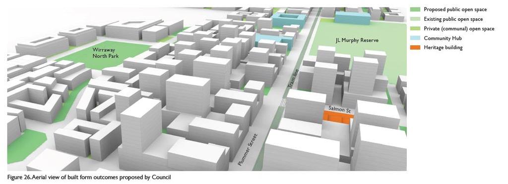
4 A mix of residential and commercial uses in the Core Area with the opportunity for more additional commercial uses and service industries in Non-Core Areas closer to the West Gate Freeway. A range of improved, expanded and new open spaces to encourage active and passive recreation, contemplation, informal small gatherings and play. These include: the existing JL Murphy Reserve; the creation of Prohasky Park (which is encompass the existing Howe Reserve); the proposed Wirraway North Park; and a series of linear parks that connect these spaces. A range of community facilities to cater for residents, families and workers including: a Sport and Recreation Hub within the proposed Prohasky Park to terminate the western vista of Plummer Street and activate the open space; a landmark Art and Cultural Hub opposite JL Murphy Reserve on Plummer Street; a pair of Education and Community Hubs comprising a primary and a secondary school also near JL Murphy Reserve; and an additional Education and Community Hub comprising a primary school located along the Tarver Street linear open space in a location that is approximately half way between JL Murphy Road and the new Prohasky Park. Vehicle, cycling and pedestrian bridge connections from Wirraway into the Employment Precinct. Improved amenity underneath the transmission lines. A transition and connections to surrounding established neighbourhoods of Port Melbourne and Garden City. These are all shown below on Council s key moves plan which has been reproduced from its Wirraway Urban Design Report.


5 4. As part of its analysis, and as noted in its Stage 2 Overarching Submissions, Council has prepared two 3D built form testing models to inform its position on Amendment GC The first model is based on the outcomes provided for by DDO30. It is a simple extrusion model of potential 3D building envelopes that shows the various height, setback and
6 overshadowing controls relative to land ownership patterns as well as existing and proposed streets and laneways to understand the possible built form outcomes allowed for by Amendment GC81. It provides a different perspective to Ms Hodyl s model which is predominantly based on the FAR controls, and which does not reflect the laneway locations shown in the Framework. Thus, Council s 3D model provides a good reference point to the maximum development outcome including FAU, while Ms Hodyl s essentially shows the minimum (i.e. FAR only) The second model illustrates the cumulative effects of Council s proposed changes to Amendment GC81 as they relate to heights, setbacks and urban structural elements such as the location of parks, community hubs, streets and laneways. So, in other words, this second model shows the development outcomes that are possible per Council s proposed changes to Amendment GC In both models, floorplate assumptions were applied to create realistic building envelopes as per those described at paragraph 134 of Council s Stage 2 Overarching Submission and the Urban Design Report that accompanied that submission. Key issues 8. Council submits that the key issues in relation to Wirraway are as follows: A lack of adequate guidance about the built form outcomes and architectural typologies that are anticipated for Wirraway. Laneways in Wirraway result in street blocks that are too large in Non-Core Areas and in long narrow building envelopes along Plummer Street. Specific sites for community hubs are not identified. The Sport and Recreation Hub and the Art and Cultural Hub are unlikely to be feasible for delivery within the proposed delivery model that aims to incorporate them into a mixed-use building via an opt-in investigation area. The investigation area for the Sport and Recreation Hub is unlikely to result in a suitable site for the Hub. The Wirraway Health and Wellbeing Hub is best located in Sandridge. There is a shortage of schools planned for Wirraway (and Fishermans Bend more broadly). 1 It is important to note that Mr Sheppard s assessment is based largely on Ms Hodyl s 3D assessment supplemented by some limited modelling carried out by David Lock & Associates.
7 A Core Retail Area is not identified, or planned for Wirraway which may result in anchor retail land uses being crowded out by residential uses. The Primary Active Frontage stretches too far along Plummer Street. There is no documented future urban structure defined for Wirraway in Amendment GC81. The 24-storey height limit in the Core Area of Wirraway is not consistent with the Vision. The proposed street wall conditions in the Core Area of Wirraway along Plummer Street create a stepped / wedding cake outcome and do not reinforce the primacy of Plummer Street or create a fine grain character. The desire for ground level communal open space in perimeter block or courtyard style developments in the Non-Core Area of Wirraway is likely to be frustrated by the need to accommodate car parking. Summary of Council s position on the key issues Built form outcomes and architectural typologies 9. The character area / neighbourhoods as proposed in the MSS for Wirraway should be modified in the manner shown in these submissions. This would allow for more refined guidance to be provided about the built form outcomes and architectural typologies that are anticipated for Wirraway. 10. Further to this, a precinct-specific DDO schedule should be created for Wirraway (as well as for other precincts per Council s previous submissions), including statements relating to the preferred built form outcome and architectural typologies for each neighbourhood within the precinct. 11. Given that the preferred character statements outline built form outcomes, Council submits that they ought to provide the basis for exercising discretion under the DDO. On this basis, Council considers that this is the most appropriate location for the sub-precinct character statements. Laneways 12. Laneways in Wirraway should be reoriented to run predominantly perpendicular to Plummer Street and should be 12 metres wide.
8 13. Large blocks in the Non-Core Area of Wirraway should be broken up into building widths of no more than 50 metres in length through breaks in buildings, through block links and/or laneways. Community Hubs 14. The Health and Wellbeing Hub should be relocated to the Core Area of Sandridge. 15. The Sport and Recreation Hub should be located within the proposed Prohasky Park at the termination of Plummer Street. 16. A primary school based Education and Community Hub and the Art and Cultural Hub should be located along Plummer Street within the Goodman owned land. 17. A second primary school based Education and Community Hub for Wirraway should be located at the corner of Tarver Street and Smith Street. 18. The secondary school based Education and Community Hub should be located on the government owned land on the corner of Plummer Street and Graham Street. Core Retail Area and active frontages 19. A Core Retail Area should be identified on the four blocks fronting the intersection of Plummer Street and Salmon Street, with Primary Active Frontages limited to limited to Plummer and Salmon Streets in this area. 20. The remainder of Plummer Street should be changed to be a Secondary Active Frontage. Future Urban Structure 21. An Urban Structure Plan in the form proposed by Council should be included within CCZ1 to help guide land use and development decisions. Building and street wall heights 22. The Core Area of Wirraway should be limited to a discretionary building height of 15 storeys. 23. A tooth and gap approach should be applied to heights along Plummer Street to better balance the amenity of the street with its built form presence. 24. Communal open space in the Non-Core Area of Wirraway should be allowed to occur on the first level if it is accessible from the street level and decked above a sleeved, ground floor car parking area.

9 Submissions Built form outcomes and architectural typologies 25. Council has made a range of general submissions regarding the need for more refined statements about the built form outcomes and architectural typologies. This precinct based submission makes further submissions about where they should apply and how they ought to be given effect for Wirraway. 26. Council recommends that the character areas / neighbourhoods that are currently proposed for Wirraway in the MSS be modified in the manner shown in the below diagram. 27. As well as proposing changes to the boundaries of these sub-precincts, Council also proposes that further information is added to the map of character areas which explains the preferred building typologies for each of the neighbourhoods. This is shown below.

10 28. Given that the proposed preferred character statements concern built form outcomes, Council submits that this ought to be the basis for exercising discretion under the DDO. On this basis, Council considers that they should be included within the DDO, rather than the MSS. 29. Accompanying this, a precinct-specific DDO schedule should be created for Wirraway (as well as for other the precincts per Council s other submissions on this issue), including statements relating to the preferred built form outcome and architectural typologies for each neighbourhood within the precinct. Laneways 30. Council understands that the Minister now proposes to show indicative locations of laneways within CCZ1 and require development to be generally in accordance with these locations. Council supports this approach. 31. As demonstrated in Council s Overarching and Sandridge Urban Design Reports, the location of laneways can significantly alter development outcomes. As is the case in Sandridge, Amendment GC81 proposes predominantly east-west laneways in Wirraway, particularly near Plummer Street. This results in narrow building envelopes and poor solar orientation. 32. Proposed north-south laneways in Wirraway are sparingly spaced creating blocks of almost 200 metres in length. Conversely, east-west laneways create narrow blocks of that are as small as 35 metres.


11 33. Council proposes that a greater proportion of north-south laneways would address these issues. This is shown below.

12 34. In addition to this spatial reorganisation, Council recommends that laneways in Wirraway are increased to a width of 12 metres 2. This will provide opportunities for landscaping and tree planting to enhance the landscape character of Wirraway and allow for a greater sense of address. The proposed width of 12 metres creates a point of difference to the more urban character in Sandridge where 9 metres wide lanes are sought. Council considers that this will help to reinforce the Vision for Wirraway. Community Hubs 35. As outlined at each stage of the Hearing, Council considers that the nomination of specific sites for future community hubs is required to ensure that they can be feasibly delivered when they are required and to an appropriate standard. This would entail identifying the site, costing the infrastructure and then including it in a DCP. 36. Per Council s Sandridge Submission, it is submitted that the Health and Wellbeing Hub proposed for Wirraway ought to be relocated to the core of Sandridge so that it is more 2 This change necessitates a change to the definition of laneways in the DDO.
13 centrally located to serve a broader catchment within Fishermans Bend (noting one is not proposed in Sandridge or Montague). Sports and Recreation Hub 37. As noted throughout submissions to the Hearing, Council relies on the Mesh Report which outlines the difficulties of locating Sport and Recreation Hubs within mixed use buildings. 38. In relation to Wirraway, this issue is compounded by the fact that the investigation area for this hub is such that only a few sites are large enough to accommodate the facility. When one also considers the 4-storey height limit in this location, it is obvious that the proposed approach is inadequate. 39. Council therefore considers that a specific stand-alone site must be earmarked for the Wirraway Sport and Recreation Hub. 40. Such is the case with its submission to the Montague Precinct Hearing, Council also considers that there are substantial benefits associated with co-locating such a facility within a large area of open space. Council accordingly submits that the Wirraway Sport and Recreation Hub should be located within the proposed Prohasky Park. A key benefit of this location is also that it has the potential to create a major civic presence at the termination of the Plummer Street Civic Boulevard and will help to activate the park (refer to Recommendation 3 and Figure 12 in the Wirraway Urban Design Report. Art and Cultural Hub 41. Given that Art and Cultural Hubs are likely to accommodate performing arts spaces, Council considers that it is likely that these types of facilities will encounter similar difficulties to Sport and Recreation Hubs and may not be feasible to deliver within a mixed-use building. 42. Council also considers that an Art and Cultural Hub has the potential to form a major placemaking role in the development of Wirraway and thus, that a prominent location on the Plummer Street Civic Boulevard adjacent to public open space that is close to the key retail area ought to be selected. 43. It is also noted that the submission from Goodman indicates a desire to deliver a series of community hubs on its land. Council has accordingly suggested a location on Goodman s land for this important hub. Education and Community Hubs 44. As outlined in Council s Stage 1 Submission to the Hearing, there is likely to be a significant shortfall in school provision in Fishermans Bend when one considers the projected demographic profile for the area per DELWP s Demographic Report. This shortfall will be
. 46.")
14 compounded if Council s concerns around the significant additional population that is likely to reside in Fishermans Bend come to fruition. 45. For this reason, Council has proposed two primary school based Education and Community Hubs in Wirraway (as opposed to the one proposed by the Framework). 46. One site is proposed opposite JL Murphy Reserve within the Goodman land for reasons similar to those outlined above for the Arts and Cultural Hub. A second site is proposed along Tarver Street approximately halfway between JL Murphy Reserve and the proposed Prohasky Park. This location has the added benefit of being located on what is likely to be a quieter street and will have the benefit to be flanked by a linear open space reserve which will help to encourage active transport to the school and provide easy access to the two large open space areas. 47. In relation to the secondary school based Education and Community Hub which was announced for funding in the recent State Budget, Council has suggested the government owned land on the corner of Plummer Street and Graham Street abutting JL Murphy Reserve (noting that the Government is yet to confirm a site in relation to the State Budget announcement). 48. These sites are shown in the below map.
15 Core Retail Area and active frontages 49. Council has advocated throughout this process for the definition of Core Retail Areas within the broader Core Areas that are defined in Amendment GC81. The reasons for this position are not re-stated here. 50. As it applies to Wirraway, Council considers that the corner of Plummer Street and Salmon Street should be the centre of activity for the precinct. This would not appear to be a particularly controversial proposition. Council accordingly considers that the four street blocks fronting this intersection should be identified as the Core Retail Area for Wirraway. 51. The proposed identification of a Core Retail Area has flow on effects for the designation of Primary and Secondary Active Frontages on Plummer and Salmon Streets. Council submits that the Primary Active Frontages should be confined to this area, while the Secondary Active Frontage should continue in either direction from that point along Plummer Street and in other streets within the broader Core Area. 52. Council also recommends that Secondary Active Frontages are applied to one laneway per block in the Core Retail Area. This will ensure that key lanes are activated with retail and commercial uses, provide a continuity of activity through the centre of large blocks and provide the opportunity for a different retail offer. 53. This change in the designation of active frontages will ensure that the Plummer Street in this central part of Wirraway will be a vibrant hub of activity (noting that the Amendment GC81 proposed to activate an extremely long section of Plummer Street of approximately 700 metres). 54. These changes are shown below.

16 55. In addition, and in line with previous submissions, Council seeks the application of the DPO to this Core Retail Area to ensure that key anchor land uses are protected, and that detailed master planning to knit these uses into the urban structure are also proposed. 3 Additionally the DPO could assist with integrating / planning for the Metro Station in this location should it take the southern alignment through Wirraway. Urban Structure 56. As is the case with retail, Council has consistently sought the greater expression of urban structure within Amendment GC81. Again, the reasons for this do not need to be re-stated here. A proposed urban structure which can guide land use decisions within CCZ1 is included below and can be found on page 25 of the Wirraway Urban Design Report. 3 Council also supports the application of the DPO to the contiguously owned Goodman properties in Wirraway and Sandridge to enable them to pursue a master planned approach to their development and to achieve, amongst other things, the redistribution of FAU across their site in line with that master plan.

17 Building and street wall heights Plummer Street 57. Plummer Street, and the broader Wirraway Core Area is intended under the Vision to have a lower scale, more intimate feel than is the case along Fennell Street in Sandridge. 58. Council considers that this will be achieved through the delivery of predominantly mid-rise scale buildings, with some taller elements. 59. However, Amendment GC81 proposes to apply a 24-storey height limit on a significant part of the Core Area of Wirraway. Council submits that this is incongruent with the intention for this area, and ought to be avoided. Council submits that this area be nominated for a 15- storey height limit. 60. The proposed maximum height of 24 storeys is inconsistent with the vision for a mid-rise precinct. 61. Due to the overshadowing controls along Plummer Street, the highest buildings (24 storeys) are located away from Plummer Street. This creates streets which have tall buildings along one side and much lower buildings on the other side (e.g. 4, 6 and 12 storeys). This creates a poor transition and scale imbalance to these lower scale heights. It also detracts from legibility and the role of Plummer Street as the primary street in Wirraway (for further information regarding this, refer to Figures 16 and 18 on pages 28 and 29 of the Wirraway Urban Design Report). 62. The proposed 6 storey street wall along Plummer Street with 12 and 24 storeys to the north creates an undesirable stepped wedding cake type outcome to comply with the


18 overshadowing controls and ensure a high amenity environment on the south side of Plummer Street. 63. Council submits that a version of its proposed tooth and gap approach proposed as part of the Montague Urban Design Report should be applied to buildings along Plummer Street to deliver a better balance between sunlight penetration and built form presence. 64. The tooth and gap approach consists of setting a lower base building height and then allowing taller elements to be built sheer to the street for part of the frontage. It has been used in the Massena Quarter in Paris (refer to the Wirraway Urban Design Report for detail regarding this). 65. To work effectively for Plummer Street, the tooth and gap approach requires the following controls:
19 Development not exceeding 8 storeys in height along the north side of Plummer Street (to avoid overshadowing the southern footpath at the September Equinox) (reduced from 12 storeys) and 15 storeys along the south side of Plummer Street (reduced from 24 storeys). For sites with a frontage to Plummer Street of 50 metres or wider, at least 20 percent of the building height at the street edge must be 4 storeys in height with the remaining height up to 8 storeys. Any element higher than 4 storeys must not be wider than 30 metres and any element above 4 storeys must also be adjacent to a 4storey element. For sites with a frontage of less than 50 metres, at least 40 percent of the building height at the street edge must be 4 storeys in height with the remaining height may be up to the discretionary height limit. For all sites with a frontage to Plummer Street, within a depth of 20 metres from the street frontage, buildings should be built sheer to the street and should not include pop-up levels or upper level setbacks. Limit the length of taller elements along lanes to 40 metres. 66. The tooth and gap approach creates a more articulated and varied street edge than what could be achieved with a continuous 8 storey street wall and upper level setback 67. This approach (and accompanying changes to building heights) has the benefit of: breaking up the building massing and creating a finer grain outcome; creating slender vertical elements and narrow and fast moving shadows at the street level; presenting a more appropriate scale to the Plummer Street Civic Boulevard; providing development opportunities appropriate to the location; allowing variation between the northern and southern side of the street, with higher elements up to 15 storeys permitted on the southern side; and providing a more appropriate transition to lower heights to the north and south of Plummer Street. 68. Figures 22, 26 and 28 on Pages 32, 35 and 36 respectively of the Wirraway Urban Design Report illustrate this approach. Figure 29 on Page 37 illustrates the proposed changes to building heights.
20
21

22 Mid-rise development 69. As outlined in Council s Overarching Urban Design Report, Council benchmarked a series of mid-rise developments to understand the key characteristics of this form of development. This benchmarking was then used to assess Amendment GC81, with regard for the Non- Core blocks of Wirraway. 70. The modelling demonstrated the following (see Figures 30 and 31 below from Pages of the Wirraway Urban Design Report): Block sizes in Wirraway are too large (block dimensions of approximately 200 metres by 100 metres) and should be broken up to ensure permeability, avoid long monotonous facades and maintain a human scale of development. The application of the 30 percent communal open space requirement and 70 percent site coverage requirement is critical in supporting adequate separation distances between buildings and space around buildings. However, raised communal open space would be required to accommodate sleeved car parking at ground level (noting that basement car-parking is unlikely to be feasible).

23 A 6-storey street wall edge aligning with the street will create an appropriate scale and street enclosure of 1:1 ratio with new streets of 22 metres in width, ensuring sky views. Laneways of 12 metres in width provide better street and building amenity and contribute to the character of Wirraway. Laneways provide opportunities for lower scaled built form such as blocks and row houses creating a street enclosure of 1.3:1 for a 4 storey street wall height to ensure better sky views and amenity to the street and within buildings.
24
25 71. Based on the benchmarking, Council submits that the following is required: Provision of a minimum area of communal open space in all developments in Non- Core Areas of Wirraway. Allowance for communal open space to be provided above on the first level to accommodate car parking where direct access to the street from the communal open space is provided. Sleeving and integration of car parking at street level and above (where provided). Adequate separation distances between buildings. Diversity within the development through different built form scales such as low rise fronting the lanes and taller heights on the edges. Address transitions in building height by whole buildings rather than rather than a stepped / wedding cake approach. Create permeability through the blocks through lanes or breaks in buildings. Break up large blocks into smaller, more human scaled buildings by limiting midrise building lengths to 50 metres through the provision of lanes or through block links or breaks in buildings to provide more opportunities for individual identity, allow for better views/outlook, daylight and sunlight to dwellings and communal spaces and reduce the impact of large, slow moving shadows. 72. The figure from Page 42 of the Urban Design Report illustrates two examples of outcomes which illustrate these principles.

26 Specific changes requested 73. The various recommendations set out in the Wirraway Report should be adopted. They include the following outcomes and changes: Amend the character areas / neighbourhoods that are currently proposed for Wirraway in the MSS in the manner shown in these submissions. Create a precinct-specific DDO schedule for Wirraway which includes statements relating to the preferred built form outcome and architectural typologies for each neighbourhood within the precinct. Amend the CCZ1 and DDO30 to show laneways as per this submission, until further work is undertaken through detailed Precinct Planning. Amend DDO30 to specify a minimum width of 12 metres for laneways in Wirraway and make the corresponding change to the definition of laneway in the Wirraway DDO. Include a plan in the CCZ1 showing the Wirraway Urban Structure as per this submission.
27 Closing Locate the Wirraway Art and Cultural Hub on Plummer Street (part of 62 Salmon Street) abutting the proposed public open space. Locate the Wirraway Education and Community Hub (Secondary School) on the government owned land adjacent to JL Murphy Reserve (477 Graham Street). Locate the Wirraway Education and Community Hub (Primary School) on the corner of Tarver Street and Smith Street (21 Smith Street). Nominate an additional Wirraway Education and Community Hub (Primary School) on the Goodman owned land directly north of JL Murphy Reserve (within 62 Salmon Street). Move the Wirraway Health and Wellbeing Hub to Sandridge. Amend Active Frontages in DDO30 and CCZ1 as per this submission. Nominate the Core Retail Area in Wirraway as the four street blocks at the intersection of Plummer Street and Salmon Street. Identify one north-south lane per block within the Core Retail Area as a Secondary Active Frontage. Apply a DPO to protect long term large floorplate anchor retail land use opportunities for the Core Retail Area in Wirraway. Reduce maximum building heights in DDO30 for the Wirraway Core to encourage a diversity of mid-rise building typologies by reducing all 24 storey areas to 15 storeys. Reduce all 12 storey areas on the northern side of Plummer Street in the Core Area to 8 storeys. Amend DDO30 to apply a tooth and gap approach to sites with a frontage to Plummer Street in the Core Area, as per this submission. Amend the DDO30 as per Recommendations 8 and 14 in Council s Overarching Urban Design Report to provide clarity for mid-rise built form outcomes. 74. This completes Council s opening Wirraway submissions. Terry Montebello Maddocks Lawyers for Port Phillip City Council
Proposed Amendment GC81 to the Port Phillip Planning Scheme Fishermans Bend
 Date: 18 April 2018 Lawyers Collins Square, Tower Two Level 25, 727 Collins Street Melbourne VIC 3008 Australia Telephone 61 3 9258 3555 Facsimile 61 3 9258 3666 info@maddocks.com.au www.maddocks.com.au
Urban Design Expert Evidence Leanne Hodyl
 Fishermans Bend GC81 Panel Hearing Urban Design Expert Evidence Leanne Hodyl 14 March 2018 1 Fishermans Bend GC81 Panel Hearing - Urban Design Expert Evidence Leanne Hodyl Overview 1. Role of the Urban
DRAFT PLANNING SCHEME AMENDMENT GC81
 Outline of changes proposes to the Melbourne and Port Phillip Planning Scheme Fishermans Bend Fishermans Bend is one of several priority precincts identified in Plan Melbourne and plays a central role
Fishermans Bend Urban Design Strategy
 Prepared for Fishermans Bend Taskforce, DELWP September 2017 Fishermans Bend Urban Design Strategy Summary 1. The purpose of the Urban Design Strategy 2. The need for a new strategy 3. Method of preparing
Prepared for Fishermans Bend Taskforce, DELWP September Fishermans Bend Urban Design Strategy
 Prepared for Fishermans Bend Taskforce, DELWP September 2017 Fishermans Bend Urban Design Strategy Summary 1. The purpose of the Urban Design Strategy 2. The need for a new strategy 3. Method of preparing
1.0 Introduction Context Physical Context Strategic Context Approved and Proposed Developments...
 Julia Bell April 2018 Instructed by Minter Ellison On behalf of Submitter 202 Date of site inspection 26 March 2018 Contents 1.0 Introduction... 3 2.0 Context... 4 2.1 Physical Context... 4 2.2 Strategic
Amendment GC81. Expert Urban Design Evidence. Fishermans Bend - Sandridge. Mark Sheppard March 2018
 Expert Urban Design Evidence Mark Sheppard March 2018 Instructed by Norton Rose Fulbright, Planning & Property Partners and Russell Kennedy On behalf of Various landowners Mark Sheppard Contents 1.0 Introduction...
SCHEDULE 12 TO THE DESIGN AND DEVELOPMENT OVERLAY GLEN WAVERLEY ACTIVITY CENTRE STRUCTURE PLAN
 DD/MM/YY Proposed C120 SCHEDULE 12 TO THE DESIGN AND DEVELOPMENT OVERLAY Shown on the planning scheme map as DDO12. GLEN WAVERLEY ACTIVITY CENTRE STRUCTURE PLAN 1.0 Design objectives DD/MM/YY Proposed
Fishermans Bend Draft Planning Scheme Amendment GC81. Minister for Planning Part A Response
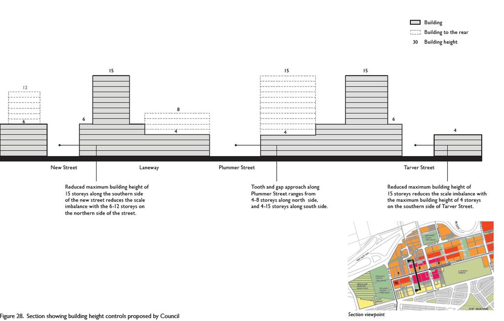
 Fishermans Bend Draft Planning Scheme Amendment GC81 Contents List of Acronyms... 1 Section 1: Introduction... 2 Section 2: Overview... 4 Section 3: Background to the Amendment... 6 Physical Context...
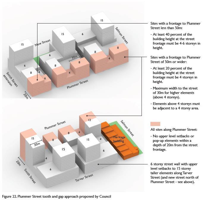
ELMVALE ACRES SHOPPING CENTRE MASTER PLAN
 ELMVALE ACRES SHOPPING CENTRE MASTER PLAN Contents 1.0 INTRODUCTION... 2 2.0 LOCATION... 2 3.0 EXISTING CONTEXT... 2 4.0 VISION & GUIDING PRINCIPLES... 2 5.0 LAND USE AND BUILT FORM... 4 5.1 St. Laurent
I615. Westgate Precinct
 I615. Westgate Precinct I615.1. Precinct Description The Westgate Precinct is located approximately 18km west of the Auckland city centre. There are seven Sub-precincts in the Westgate Precinct: Sub-precinct
Chapter 2: OUTLINE PLANNING APPLICATION PROPOSALS. A New Garden Neighbourhood Matford Barton 17
 Chapter 2: OUTLINE PLANNING APPLICATION PROPOSALS A New Garden Neighbourhood Matford Barton 17 2.1. SUMMARY AND STATUS OF THE PROPOSALS 2.1.1. The parameter plans and associated wording in this chapter
Built Form and Massing
 Initial Urban Design Assessment Former Gasworks Site, 111 Queens Parade and 433 Smith Street, Fitzroy North Prepared for Protect Fitzroy North Incorporated by David Pryor, Place Design Studio 6 April 2018
ADVISORY COMMITTEE REVIEW PANEL APPOINTED BY THE MINISTER FOR PLANNING UNDER S 151 OF THE PLANNING & ENVIRONMENT ACT 1987
 PLANNING PANELS VICTORIA IN MELBOURNE IN THE MATTER OF PROPOSED AMENDMENT CG81 ADVISORY COMMITTEE REVIEW PANEL APPOINTED BY THE MINISTER FOR PLANNING UNDER S 151 OF THE PLANNING & ENVIRONMENT ACT 1987
MVRC ARCHITECTURAL DESIGN STATEMENT
 11251 MOONEE VALLEY RACING CLUB MAY 201 CONTENTS 0 Contents Introduction 1 Site Analysis a. Site Features b. Built form Interfaces c. Existing Streetscape d. Site Opportunities and Constraints 2 Masterplan
Keystone Business Park Precinct Structure Plan North East Industrial Precinct. Part 2 Design Principles
 Keystone Business Park Precinct Structure Plan North East Industrial Precinct Part 2 Design Principles Context Issues Services Landform Issues Geotech and contamination Ecology Traffic and access Issues
Official Plan Review: Draft Built Form Policies
 PG.30.1 REPORT FOR ACTION Official Plan Review: Draft Built Form Policies Date: May 15, 2018 To: Planning and Growth Management Committee From: Chief Planner and Executive Director, City Planning Division
Land Use Amendment in Southwood (Ward 11) at and Elbow Drive SW, LOC
 at and Elbow Drive SW, LOC") 2018 November 15 Page 1 of 10 EXECUTIVE SUMMARY This land use amendment application was submitted by Rick Balbi Architect on 2017 August 31 on behalf of Sable Developments Ltd, and with authorization from
2018 November 15 Page 1 of 10 EXECUTIVE SUMMARY This land use amendment application was submitted by Rick Balbi Architect on 2017 August 31 on behalf of Sable Developments Ltd, and with authorization from
King-Spadina Secondary Plan Community Consultation Meeting. Michelle Knieriem, City Planner October 11, 2017
 King-Spadina Secondary Plan Community Consultation Meeting Michelle Knieriem, City Planner October 11, 2017 Agenda 6:30 Welcome 6:35 Presentation 7:15 Question and Answer Session 8:15 Closing Remarks HOW
WELLINGTON HOSPITAL DESIGN GUIDE TABLE OF CONTENTS
 WELLINGTON HOSPITAL DESIGN GUIDE TABLE OF CONTENTS 1.0 Introduction Page 2 The Place of Wellington Hospital 2 The Future of the Hospital 2 2.0 The Intention of the Design Guide 3 3.0 Analysis 4 General
CITY OF FREMANTLE LOCAL PLANNING SCHEME NO. 4 AMENDMENT NO. 68 SCHEME AMENDMENT REPORT
 CITY OF FREMANTLE LOCAL PLANNING SCHEME NO. 4 AMENDMENT NO. 68 SCHEME AMENDMENT REPORT CITY OF FREMANTLE PLANNING AND DEVELOPMENT SERVICES 8 WILLIAM STREET FREMANTLE WA 6160 PLANNING AND DEVELOPMENT ACT
Peer Review: East Village Urban Design Report
 Peer Review: East Village Urban Design Report Client: Victorian Planning Authority ABN: 77 803 352 468 Prepared by Australia Pty Ltd Level 10, Tower Two, 727 Collins Street, Melbourne VIC 3008, Australia
The Master Plan Framework
 The Master Plan Framework The East Harbour Master Plan advances the development of 60 acres of former industrial lands east of the Don River. The Master Plan outlines a vision for a vibrant, transit-oriented
Regency Developments. Urban Design Brief. Holyrood DC2 Rezoning
 Regency Developments Urban Design Brief Holyrood DC2 Rezoning Stantec Consulting Ltd. 7-31-2017 1. Overview Regency Developments intends to rezone the lands located at 8510 and 8511 93 Avenue, within the
DAREBIN PLANNING SCHEME AMENDMENT C137
 Who is the planning authority? Planning and Environment Act 1987 DAREBIN PLANNING SCHEME AMENDMENT C137 EXPLANATORY REPORT This amendment has been prepared by the Darebin City Council, who is the planning
ARLINGTON COUNTY, VIRGINIA
 ARLINGTON COUNTY, VIRGINIA County Board Agenda Item Meeting October 15, 2005 DATE: September 28, 2005 SUBJECT: Request to Advertise the adoption of the 2005 Clarendon Sector Plan C. M. RECOMMENDATION:
TALL BUILDING GUIDELINES
 TALL BUILDING GUIDELINES Urban Design Guidance for the Site Planning and Design of Tall Buildings in Milton May, 2018 A Place of Possibility Contents 1.0 INTRODUCTION 1 1.1 What is a Tall Building? 2
Appendix 7 Precinct Analysis Carlton
 Appendix 7 Precinct Analysis Carlton (Andover Street) Rezone from R2 Low Density Residential to R3 Medium Density Residential Retain existing B1 Neighbourhood Centre zone Existing Zoning Map (R2 Low Density
QUEEN-RIVER SECONDARY PLAN
 34 QUEEN-RIVER SECONDARY PLAN 34. QUEEN RIVER SECONDARY PLAN 1. INTRODUCTION The Queen-River area is approximately 6.4 hectares and is located at the eastern edge of the Downtown as shown on Map 34-1.
Welcome. Walk Around. Talk to Us. Write Down Your Comments
 Welcome This is an information meeting introducing the applications for proposed redevelopment of the Yorkdale Shopping Centre site at 3401 Dufferin Street and 1 Yorkdale Road over the next 20+ years,
CRYSTAL CITY BLOCK PLAN # CCBP- G 1 DRAFT
 CRYSTAL CITY BLOCK PLAN # CCBP- G 1 DRAFT BLOCK G (Metro Market Square block) Long Range Planning Committee Meeting January 29, 2018 1 1. Introduction 2 1. LRPC Meeting Purpose Review of proposed Crystal
13 THORNHILL YONGE STREET STUDY IMPLEMENTATION CITY OF VAUGHAN OPA 669 AND TOWN OF MARKHAM OPA 154
 13 THORNHILL YONGE STREET STUDY IMPLEMENTATION CITY OF VAUGHAN OPA 669 AND TOWN OF MARKHAM OPA 154 The Planning and Economic Development Committee recommends the adoption of the recommendations contained
Little Mountain UDP Presentation
 Summary of UDP Evaluation of Dec 2015 Plan Dec 2015 Site Plan Transitional edges work well Central spine and permeability are strong Tree retention is good Establish Big Idea Sameness of built form contributes
FORMER CANADIAN FORCES BASE (CFB) ROCKCLIFFE SECONDARY PLAN. Official Plan Amendment XX to the Official Plan for the City of Ottawa
 ROCKCLIFFE SECONDARY PLAN. Official Plan Amendment XX to the Official Plan for the City of Ottawa") FORMER CANADIAN FORCES BASE (CFB) ROCKCLIFFE SECONDARY PLAN Official Plan Amendment XX to the Official Plan for the City of Ottawa 1 INDEX THE STATEMENT OF COMPONENTS PART A THE PREAMBLE PAGE Purpose...
FORMER CANADIAN FORCES BASE (CFB) ROCKCLIFFE SECONDARY PLAN Official Plan Amendment XX to the Official Plan for the City of Ottawa 1 INDEX THE STATEMENT OF COMPONENTS PART A THE PREAMBLE PAGE Purpose...
Chapter 5 Urban Design and Public Realm
 5.1 Introduction Public realm is all areas of the urban fabric to which the public have access. It is where physical interaction takes place between people. It therefore, includes buildings and their design,
WEST LOOP DESIGN GUIDELINES CHECKLIST
 WEST LOOP DESIGN GUIDELINES CHECKLIST Section 1.0 General Strategies 1.1 DESIGN EXCELLENCE: ENCOURAGE HIGH QUALITY AND INNOVATIVE DESIGN OF NEW BUILDINGS WITHIN THE WEST LOOP WITHOUT BEING PRESCRIPTIVE
6 Site Framework Strategies
 6 Site Framework Strategies 6.1 Introduction Section 6 identifies a number of specific areas which are considered to be key sites within the Plan area and which may have potential for development / redevelopment.
Library of Birmingham integrated with The REP
 0123456789 Birmingham City Council Library of Birmingham integrated with The REP Environmental Statement Chapter 9 Shadowing 9 Shadowing Chapter Summary Key features A private amenity garden is located
PART AOTEA PRECINCT
 CONTENTS... PAGE AOTEA PRECINCT...4 14.5.1 INTRODUCTION...4 14.5.2 RESOURCE MANAGEMENT ISSUES...4 14.5.3 RESOURCE MANAGEMENT OBJECTIVES AND POLICIES... 4 14.5.4 RESOURCE MANAGEMENT STRATEGY...5 14.5.5
KOGARAH CITY COUNCIL a better lifestyle. Appendix 7 Precinct Analysis Blakehurst
 Appendix 7 Precinct Analysis Blakehurst (Blakehurst Centre) Rezone from R2 Low Density Residential to R3 - Medium Density Residential Rezone from B1 Neighbourhood Centre to B2 Local Centre Existing Zoning
Uptown Rideau Street Secondary Plan [Amendment #166, January 12, 2016]
![Uptown Rideau Street Secondary Plan [Amendment #166, January 12, 2016]](/thumbs/76/73760497.jpg "Uptown Rideau Street Secondary Plan [Amendment #166, January 12, 2016]") [Amendment #166, January 12, 2016] The policies of this Secondary Plan are in effect, save and except for the property at 560 Rideau Street, for which there remains a site specific appeal to this Secondary
[Amendment #166, January 12, 2016] The policies of this Secondary Plan are in effect, save and except for the property at 560 Rideau Street, for which there remains a site specific appeal to this Secondary
Mid-Rise Buildings on Toronto s Avenues Responding to the Public Realm Andrea Oppedisano, City of Toronto
 Mid-Rise Buildings on Toronto s Avenues Responding to the Public Realm Andrea, City of Toronto Introduction The Avenues and Mid-Rise Buildings Study explores opportunities to encourage a built form that
McCowan Precinct Plan Study Background & Deliverables
 1 DRAFT & WITHOUT PREJUDICE McCowan Precinct Plan Study Background & Deliverables In September, 2011, City Planning (Scarborough District) began a study of an area within the Scarborough Centre, identified
INCREMENTAL CHANGE AREA REVIEW March 2015 Page 1
 INCREMENTAL CHANGE AREA REVIEW March 2015 Page 1 Table of Contents Introduction... 3 Background to Review... 3 Comparison of the Schedules to the General Residential Zone... 7 Methodology... 7 Policy Context...
Draft Western District Plan
 Powered by TCPDF (www.tcpdf.org) Draft Western District Plan Submission_id: 31440 Date of Lodgment: 15 Dec 2017 Origin of Submission: Online Organisation name: Goodman Property Services Australia Pty Ltd
Newcourt Masterplan. November Exeter Local Development Framework
 Newcourt Masterplan November 2010 Exeter Local Development Framework Background The Exeter Core Strategy Proposed Submission sets out the vision, objectives and strategy for the development of Exeter up
Urban Design Manual PLANNING AROUND RAPID TRANSIT STATIONS (PARTS) Introduction. Station Study Areas
 Introduction. Station Study Areas") 111111 PLANNING AROUND RAPID TRANSIT STATIONS (PARTS) Introduction The ION rapid transit system will link Waterloo, Kitchener and Cambridge through a central transit corridor (CTC). There are a number
111111 PLANNING AROUND RAPID TRANSIT STATIONS (PARTS) Introduction The ION rapid transit system will link Waterloo, Kitchener and Cambridge through a central transit corridor (CTC). There are a number
REQUEST Current Zoning: O-15(CD) (office) Proposed Zoning: TOD-M(CD) (transit oriented development mixed-use, conditional)
 (office) Proposed Zoning: TOD-M(CD) (transit oriented development mixed-use, conditional)") Rezoning Petition 2016-117 Zoning Committee Recommendation January 4, 2017 REQUEST Current Zoning: O-15(CD) (office) Proposed Zoning: TOD-M(CD) (transit oriented development mixed-use, conditional) LOCATION
Rezoning Petition 2016-117 Zoning Committee Recommendation January 4, 2017 REQUEST Current Zoning: O-15(CD) (office) Proposed Zoning: TOD-M(CD) (transit oriented development mixed-use, conditional) LOCATION
30 and 44 Zorra Street - Zoning By-law Amendment Application - Preliminary Report
 STAFF REPORT ACTION REQUIRED 30 and 44 Zorra Street - Zoning By-law Amendment Application - Preliminary Report Date: March 14, 2016 To: From: Wards: Reference Number: Etobicoke York Community Council Director,
SEPP 65 & APARTMENT DESIGN GUIDE
 SEPP 65 & APARTMENT DESIGN GUIDE Response to draft Issued for public consultation Submission from Planning Institute of Australia November 2014 NSW Office Suite 3, Level 11 221 Miller Street North Sydney
REZONING POLICY FOR CHINATOWN SOUTH (HA-1A) Adopted by City Council on April 19, April 2011
 Adopted by City Council on April 19, April 2011") $1 City of Vancouver Land Use and Development Policies and Guidelines Community Services, 453 W. 12th Ave Vancouver, BC V5Y 1V4 F 604.873.7000 fax 604.873.7060 planning@vancouver.ca REZONING POLICY FOR
$1 City of Vancouver Land Use and Development Policies and Guidelines Community Services, 453 W. 12th Ave Vancouver, BC V5Y 1V4 F 604.873.7000 fax 604.873.7060 planning@vancouver.ca REZONING POLICY FOR
Workshop 3. City of Burlington Waterfront Hotel Planning Study. September 14, The Planning Partnership
 Workshop 3 City of Burlington Waterfront Hotel Planning Study September 14, 2017 The Planning Partnership The Waterfront Hotel Planning Study 01 The Brant & Lakeshore Planning Study will establish a Strategic
1.0 Purpose of a Secondary Plan for the Masonville Transit Village
 Report to Planning and Environment Committee To: Chair and Members Planning & Environment Committee From: John M. Fleming Managing Director, Planning and City Planner Subject: Masonville Transit Village
Colchester Northern Gateway Master Plan Vision Review Draft. July 2016
 Colchester Northern Gateway Master Plan Vision Review Draft July 2016 Contents Introduction 4 Context 8 Purpose of the Report 8 Strategic Position 9 Overview of the Process 11 2012 Master Plan Vision 12
Urban Design Guidelines
 Urban Design Guidelines These Urban Design Guidelines comprise the Key Design Objectives below, the Roads Design Guidelines overleaf and Neighbourhood Framework Plans. Together with Section 3: Urban Design
2.0 Urban Design Concepts
 0 Urban Design Concepts Urban Design Concept diagrams The Waterfront Axis The Park Axis The Wharf Axis Waterfront Precincts 0.1 The Four Key Concepts: This Concept for the Wynyard Quarter establishes four
St. Lawrence Neighbourhood Focused Area - Official Plan Amendment Status Report
 STAFF REPORT ACTION REQUIRED St. Lawrence Neighbourhood Focused Area - Official Plan Amendment Status Report Date: May 21, 2015 To: From: Wards: Reference Number: Toronto and East York Community Council
1071 King Street West Zoning Amendment Application - Preliminary Report
 STAFF REPORT ACTION REQUIRED 1071 King Street West Zoning Amendment Application - Preliminary Report Date: August 9, 2012 To: From: Wards: Reference Number: Toronto and East York Community Council Director,
Section 5 (S5) - Sneydes Parade
 - Sneydes Parade") EAST WERRIBEE EMPLOYMENT PRECINCT PRECINCT STRUCTURE PLAN 15m High Large Canopy Tree encouraged 41.4 6.0 4.2 2.0 0.3 300mm Kerb 3 Lane incl. dedicated bus lane 6m median (Trees at 25m spacing) 3 Lane incl.
EAST WERRIBEE EMPLOYMENT PRECINCT PRECINCT STRUCTURE PLAN 15m High Large Canopy Tree encouraged 41.4 6.0 4.2 2.0 0.3 300mm Kerb 3 Lane incl. dedicated bus lane 6m median (Trees at 25m spacing) 3 Lane incl.
Clairtrell Area Context Plan
 Clairtrell Area Context Plan March 2005 Urban Development Services City Planning Contents 1. Introduction... 4 2. Development Structure... 6 2.1 Streets... 7 2.1.1 Sheppard Avenue and Bayview Avenue...
523, 525 and 525A Adelaide Street West - Zoning Amendment Application - Preliminary Report
 STAFF REPORT ACTION REQUIRED 523, 525 and 525A Adelaide Street West - Zoning Amendment Application - Preliminary Report Date: May 12, 2012 To: From: Wards: Reference Number: Toronto and East York Community
[PLANNING RATIONALE] For Site Plan Control and Lifting of Holding Zone By-Law 101 Champagne Avenue. May 23, 2014
![[PLANNING RATIONALE] For Site Plan Control and Lifting of Holding Zone By-Law 101 Champagne Avenue. May 23, 2014](/thumbs/75/71599615.jpg "[PLANNING RATIONALE] For Site Plan Control and Lifting of Holding Zone By-Law 101 Champagne Avenue. May 23, 2014") [PLANNING RATIONALE] For Site Plan Control and Lifting of Holding Zone By-Law 101 Champagne Avenue May 23, 2014 Contents 1.0 Introduction... 2 2.0 Site Context... 2 2.1 Adjacent Uses... 2 Figure 1: Site
[PLANNING RATIONALE] For Site Plan Control and Lifting of Holding Zone By-Law 101 Champagne Avenue May 23, 2014 Contents 1.0 Introduction... 2 2.0 Site Context... 2 2.1 Adjacent Uses... 2 Figure 1: Site
GREENFORD HALL & ADJOINING LAND
 GREENFORD HALL & ADJOINING LAND CONTENTS 1. Introduction 1. Introduction 2. Urban Context 2.1 The Site and Surroundings 2.2 Urban Context Map 2.3 Access and Movement 3. Planning Context 3.1 Planning History
Greater Geelong Planning Scheme Proposed Planning Scheme Amendment C and 5-19 Princes Highway, Norlane
 Greater Geelong Planning Scheme Proposed Planning Scheme Amendment C253 PLANNING SUBMISSION prepared for Bunnings Group Ltd by SJB Planning Pty Ltd Level 1, Building D 80 Dorcas Street SOUTHBANK VIC 3006
Urban Design Guidelines Townhouse and Apartment Built Form
 Urban Design Guidelines Townhouse and Apartment Built Form Town of Wasaga Beach Table of Contents 1. Introduction 1.1. Purpose 1.2. Urban Design Principles 1.3. Application of Guidelines 2. Site Design,
Woodbrook - Shanganagh
 Section 4: Key Sites Framework Strategy Woodbrook - Shanganagh Local Area Plan 2017-2023 4. Site Framework Strategies The Master Plans shall have regard to the thematic objectives under the LAP Development
Deicke Richards Aug 2009 Rev A. Varsity Station Village A master plan for a TOD
 Deicke Richards Aug 2009 Rev A Varsity Station Village A master plan for a TOD Introduction The Varsity Station Village project is transforming empty governmentowned industrial land on Queensland s Gold
DRAFT Northeast Quadrant of Kipling Avenue and Highway 7 DRAFT AUGUST 29, Goals Land Use. The goals of this Plan are to:
 AUGUST 29, 2017 12.15 Northeast Quadrant of Kipling Avenue and Highway 7 12.15.1 Goals 12.15.2 Land Use The goals of this Plan are to: 12.15.2.1 General Provisions: a) Ensure the development of a compact
Public Open House. Overview of the Downtown Plan Official Plan Amendment April 23, 2018
 Public Open House Overview of the Downtown Plan Official Plan Amendment April 23, 2018 1 A 25-Year Plan for Downtown To ensure growth contributes positively to Toronto s Downtown as a great place to live,
DRAFT. October Wheaton. Design Guidelines
 October 2011 DRAFT Wheaton Design Guidelines 2 Draft - Design Guidelines - Wheaton Sector Plan Contents 04 Section 1: Introduction 06 Section 2: Context 08 Section 3: Design Guidelines 09 Goal 1: Create
CDAC. Update: Downtown Dartmouth Update: CDAC July 25 th Motion
 CDAC Update: Downtown Dartmouth Update: CDAC July 25 th Motion 2018-10-24 Downtown Dartmouth Plan Open House October 22, 2018 6:00 pm Open House 6:30 pm Presentation + Q&A 7:20 pm Open House 8:30 pm Close
The Humber Bay Shores. Urban Design Guidelines Update and Public Realm Plan. January, 2008
 The Humber Bay Shores Urban Design Guidelines Update and Public Realm Plan January, 2008 prepared by Brook McIlroy Planning and Urban Design / Pace Architects Content i EXECUTIVE SUMMARY KEY RECOMMENDATIONS
URBAN DESIGN BRIEF URBAN DESIGN BRIEF 721 FRANKLIN BLVD, CAMBRIDGE August 2018
 URBAN DESIGN BRIEF URBAN DESIGN BRIEF 721 FRANKLIN BLVD, CAMBRIDGE August 2018 DESIGN BRIEF CONTENTS PART A 1.0 INTRODUCTION 2.0 DESCRIPTION & ANALYSIS OF SITE CONTEXT 3.0 DESIGN CONSTRAINTS AND OPPORTUNITIES
4.0 Design Guidelines For The Village Centre. South fields Community Architectural Design Guidelines Town of Caledon
 4.0 Design Guidelines For The Village Centre 4.0 Design Guidelines for the Village Centre The Village Centre is the focal point of the entire South Fields Community and is designed as a traditional commercial
Complete Neighbourhood Guidelines Review Tool
 Complete Neighbourhood Guidelines Review Tool Prepared By: City of Regina Planning Department October 2014 Page 1 of 14 Community Development Review Checklist for Secondary Plans and Concept Plans The
4.00 STAKEHOLDERS. urbanprojects
 4.00 STAKEHOLDERS 94 heuston gateway: regeneration strategy and development framework plan 95 The Heuston Gateway presents one of the greatest concentrations of brown field development sites located adjacent
RE: AMENDMENT C375 GEELONG PLANNING SCHEME 1900 BARWON HEADS ROAD, BARWON HEADS
 Reference: #V157080 14 August 2018 Barwon Heads Lifestyle Group Pty Ltd C/- Best Hooper Lawyers Level 9, 451 Little Bourke Street MELBOURNE VIC 3000 Attention: Mr. Edward Mahony (Lawyer) Dear Edward RE:
Yonge Street Zoning Amendment Application - Preliminary Report
 STAFF REPORT ACTION REQUIRED 341-355 Yonge Street Zoning Amendment Application - Preliminary Report Date: March 24, 2011 To: From: Wards: Reference Number: Toronto and East York Community Council Director,
2.0 Strategic Context 4
 2.0 Strategic Context 4 2.1 The Area Action Plan is a non-statutory plan, which forms a corporate policy document, expressing particular issues and areas of concern while also providing a vision for the
Child Minding Centres and Family Day Care
 Child Minding Centres and Family Day Care Policy Type: Local Planning Policy Policy Owner: Director Urban Planning Policy No. LPP1.12 Last Review Date: 20 September 2016 Policy Objectives To provide for
A. WHAT IS A GENERAL PLAN?
 I. Introduction A. WHAT IS A GENERAL PLAN? A general plan is the planning guideline for the future of a city. It contains goals and policies which regulate urban development, the protection of the natural
Preston Market. Design review and master planning. Victorian Planning Authority. June 8, :24 PM. Prepared for: Date:
 Prepared for: Victorian Planning Authority Date: June 8, 2018 3:24 PM Design review and master planning Preston Market What we know about the markets Preston Markets The existing site features are: Approximately
... on the draft Arden Vision & Framework
 April 2017 Integrated world-class urban renewal Feedback... on the draft Arden Vision & Framework On 1 September 2016 the Victorian Planning Authority (VPA) released the draft Arden Vision & Framework
Part 9 Specific Land Uses - Housing on Small and Narrow Lots
 19 HOUSING ON SMALL AND NARROW LOTS This section of the DCP applies where development for the purpose of a dwelling house, attached dwellings, or semi-detached dwellings is or are proposed in the R2 Low
4.0 URBAN DESIGN FRAMEWORK. The vision for the future development of the plan area is to:
 4.0 The vision for the future development of the plan area is to: Create a new neighbourhood that focuses on the highly valued natural and aesthetic features of the lands and provides good quality homes,
THE CITY OF VAUGHAN BY-LAW BY-LAW NUMBER A By-law to adopt Amendment Number 1 to the Official Plan of the Vaughan Planning Area.
 THE CITY OF VAUGHAN BY-LAW BY-LAW NUMBER 015-2014 A By-law to adopt Amendment Number 1 to the Official Plan of the Vaughan Planning Area. NOW THEREFORE the Council of the Corporation of the City of Vaughan
Section Three, Appendix 16C Medium Density Housing, Design Assessment Criteria (Residential 8A zone)
") APPENDIX 16C MEDIUM DENSITY HOUSING, DESIGN ASSESSMENT CRITERIA (RESIDENTIAL 8A ZONE) PURPOSE OF APPENDIX 16C (RESIDENTIAL 8A ZONE) In the Residential 8A Zone the following are defined as restricted discretionary
APPENDIX 16C MEDIUM DENSITY HOUSING, DESIGN ASSESSMENT CRITERIA (RESIDENTIAL 8A ZONE) PURPOSE OF APPENDIX 16C (RESIDENTIAL 8A ZONE) In the Residential 8A Zone the following are defined as restricted discretionary
Page 1 of 19 URBAN DESIGN FRAMEWORK FOR BOLTON STREET WATERFORD
 Page 1 of 19 URBAN DESIGN FRAMEWORK FOR BOLTON STREET WATERFORD 1.0 Introduction: The relocation of the City Council stores and depot from Bolton Street creates an exciting opportunity for development
Smart Growth Development Checklist
 2004 Smart Growth Development Checklist Smart Growth Development Checklist Corporation of the City of New Westminster Guide and manage growth in a manner which is consistent with the principles of sustainable
The Humber Bay Shores. Urban Design Guidelines Update and Public Realm Plan. July, 2008
 Urban Design Guidelines Update and Public Realm Plan July, 2008 prepared by Brook McIlroy Planning and Urban Design / Pace Architects Content i EXECUTIVE SUMMARY KEY RECOMMENDATIONS iii ONE INTRODUCTION
97 Lea Bridge Road, Leyton, E10 7QL London Borough of Waltham Forest December 2015
 97 Lea Bridge Road, Leyton, E10 7QL London Borough of Waltham Forest December 2015 Public Realm and Landscape Proposals LEA BRIDGE ROAD, WALTHAMSTOW Public Realm & Landscape Proposals BDP(90)RPT001 December
The Proposed Auckland Unitary Plan (notified 30 September 2013)
") 3 Business zones Introduction There are 10 business zones in the Unitary Plan: City Centre Metropolitan Centre Town Centre Local Centre Neighbourhood Centre Mixed Use General Business Business Park Light
3 Business zones Introduction There are 10 business zones in the Unitary Plan: City Centre Metropolitan Centre Town Centre Local Centre Neighbourhood Centre Mixed Use General Business Business Park Light
Tall Buildings Strategy
 Chapter 8 Tall Building Strategy Mayor of London 115 existing & consented tall buildings effect on views of palace of westminster Chapter 8 Tall Buildings Strategy tall building cluster upto 150m with
PORT WHITBY COMMUNITY
 PORT WHITBY COMMUNITY SECONDARY PLAN UPDATE COMMUNITY IMPROVEMENT PLAN URBAN DESIGN GUIDELINES September 2015 DRAFT PROPOSED AMENDMENT NUMBER # to the Whitby Official Plan PURPOSE: The intent of this Amendment
burlington mobility hubs study Downtown Burlington Mobility Hub
 burlington mobility hubs study Downtown Burlington Mobility Hub Draft Precinct Plan Workbook PIC #3, September 7, 2017 downtown mobility hub objectives City staff and their consultants are proposing an
599 Kennedy Road - Official Plan Amendment and Zoning Amendment Application - Preliminary Report
 STAFF REPORT ACTION REQUIRED 599 Kennedy Road - Official Plan Amendment and Zoning Amendment Application - Preliminary Report Date: March 7, 2017 To: From: Wards: Reference Number: Scarborough Community
(DC1) Direct Development Control Provision DC1 Area 4
 Direct Development Control Provision DC1 Area 4") . General Purpose (DC) Direct Development Control Provision DC Area 4 The purpose of this Provision is to provide for an area of commercial office employment and residential development in support of the
. General Purpose (DC) Direct Development Control Provision DC Area 4 The purpose of this Provision is to provide for an area of commercial office employment and residential development in support of the
SCHEDULE THREE TO THE DEVELOPMENT PLAN OVERLAY EASTERN GOLF COURSE KEY REDEVELOPMENT SITE
 DD/MM/YY SCHEDULE THREE TO THE DEVELOPMENT PLAN OVERLAY Shown on the planning scheme map as DPO3 EASTERN GOLF COURSE KEY REDEVELOPMENT SITE 1.0 A permit may be granted before a development plan has been
SCHEDULE 'A' TO BY-LAW as Amended by AMENDMENT NO. 90 TO THE WHITBY OFFICIAL PLAN
 SCHEDULE 'A' TO BY-LAW 6413-10 as Amended by 6553-11 AMENDMENT NO. 90 TO THE WHITBY OFFICIAL PLAN SECTION A: GROWTH PLAN CONFORMITY PURPOSE: LOCATION: BASIS: The purpose of this Amendment is to: conform
Buildings may be set back to create small plazas provided that these setbacks do not substantially disrupt the street wall s continuity.
 6-22 Community Design Street Walls and Street-front Setbacks The siting of buildings will play a critical role in establishing the character and sense of place for the District. Siting buildings at the