7.3 Description of Section 4(f) Properties
|
|
|
- Rebecca Copeland
- 5 years ago
- Views:
Transcription
1 feet). To minimize impacts to the park, the footprint of the new facility would overlap with a large portion of the existing facilitys footprint east of the Park Presidio Interchange. 7.3 Description of Section 4(f) Properties This section describes the Section 4(f) properties that would be subject to Section 4(f) use by the proposed build alternatives, including the Preferred Alternative. These properties include: the Presidio NHLD; Doyle Drive; the Golden Gate Bridge; Marina Viaduct; the Presidio Viaduct; and Palace of Fine Arts. Exhibit 7-2 on the following page provides a listing of the resources in proximity to Doyle Drive construction The Presidio The Presidio of San Francisco, a publicly owned recreational area and historic property is located in the northwestern most point of San Francisco peninsula. The property is approximately 600 hectares (1,480 acres) in size and is both a national park and National Historic Landmark District (NHLD). The existing Doyle Drive corridor encompasses 9.1 hectares (22.5 acres) of the property. September 2008 Page 7-12 South Access to the Golden Gate Bridge - Doyle Drive FEIS/R Chapter Seven: Final Section 4(f) Evaluation
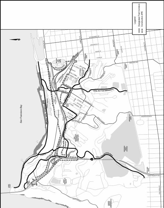
2 Exhibit 7-2 Section 4(f) Resources RESOURCE PRESIDIO OF SAN FRANCISCO DOYLE DRIVE GOLDEN GATE BRIDGE MARINA VIADUCT PRESIDIO VIADUCT PALACE of FINE ARTS and EXPLORATORIUM HISTORIC RESOURCES /RECREATIONAL ELEMENTS IN PROXIMITY TO DOYLE DRIVE CONSTRUCTION RECREATION RESOURCES Proposed Trail and Bikeway Connections (Presidio Trails and Bikeways Plan) Proposed Presidio Promenade Proposed Park Boulevard Trail Proposed Tennessee Hollow Corridor Other Recreation Facilities Building 1151 Indoor Swimming Pool Building Gymnasium HISTORIC RESOURCES (BY PLANNING DISTRICT) Fort Scott Planning District Buildings 966 and 967 Crissy Field Planning District Stables Area Buildings: 661, 662, 663, 667, 668, 669, 670, and 671 Stilwell Hall: Building 650 Building 631 Crissy Center: Building 603 Mason Street Warehouses: Buildings 1182, 1183, 1184, 1185, 1186, 1187, and 1188 South Hills Planning District National Cemetery and Its Buildings: 150, 151, 152, 153, and 154 Main Post Planning District Main Post, Vicinity of Main Parade Ground: 105, 106, 107, 108, and 210 Main Post, Vicinity of Halleck Street: 201, 204, 227, 228, and 230 Letterman Planning District Buildings 1056, 1059, 1060, 1061, 1063, and 1076 Gorgas Ave Warehouses: 1160, 1161, 1162, 1163, 1167, 1169, and 1170 Buildings 1151 and 1152 Veterans Boulevard (Route 1) Richardson Avenue (Route 101) Bank Street Battery Blaney Road Cowles Street Presidio Viaduct Marina Viaduct ROADWAYS Golden Gate Bridge Doyle Drive Historic Component Presidio Viaduct (High-viaduct) Marina Viaduct (Low-viaduct) Marina Viaduct Presidio Viaduct Palace of Fine Arts Crissy Field Avenue Girard Road Gorgas Avenue Halleck Street Lincoln Boulevard South Access to the Golden Gate Bridge - Doyle Drive FEIS/R September 2008 Chapter Seven: Final Section 4(f) Evaluation Page 7-13
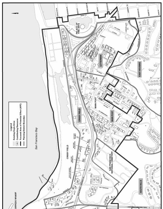
3 Access to the Presidio is provided at the following locations: Lincoln Boulevard (at the southwest), Arguello Boulevard (at the south), Presidio Boulevard and Broadway (at the southeast), Lombard Street and Gorgas Avenue (at the east), and Marina Boulevard (at the northeast). Vehicular access to the Presidio is also available from Doyle Drive via the off-ramp to Merchant Road at the Golden Gate Bridge Toll Plaza. Highway 101, crosses through the northern part of the Presidio where, from the Toll Plaza to the eastern boundary of the Presidio. It is known as Doyle Drive (or the South Access to the Golden Gate Bridge). Veterans Boulevard carries Highway 1 on a north-south alignment through the Presidio NHLD and intersects with Doyle Drive just northwest of the Cavalry Stables buildings. These two major roadways were built in the 1930s and they and their associated structures are contributing elements of the Presidio NHLD, and are therefore subject to Section 4(f). Park and Recreational Resources Park Administration In 1998, management of the Presidio was divided between two federal agencies: the Presidio Trust and the National Park Service (NPS). The Trust is responsible for oversight of 80 percent of the Presidio delineated as Area B (see Exhibit 7-1); and the NPS is responsible for management of the coastal portions of the park (the remaining 20 percent) that are delineated as Area A (see Exhibit 7-1). The Doyle Drive Project is located in Area B. The Trusts mission is to preserve and enhance the natural, cultural, scenic and recreational resources of the Presidio for public use in perpetuity, and to achieve long-term financial sustainability. The Trust expects to receive federal appropriations until 2013, at which time they must be financially self-sustaining. The Trust uses these funds and lease revenues to rehabilitate the parks buildings, restore its open spaces and historic resources, provide public programs, and maintain utilities and infrastructure. The Presidio is a unit of Golden Gate National Recreation Area (GGNRA), which is comprised of many locations in the Bay Area including Alcatraz, Marin Headlands, Fort Funston, Fort Mason, as well as Muir Woods National Monument, Fort Point National Historic Site, and the Presidio of San Francisco. The GGNRA, the worlds largest urban national park, covers a total area of 30,513 hectares (75,398 acres) of land and water, including approximately 45 kilometers (28 miles) of coastline. Park and Recreational Resources The Presidio provides a unique experience for visitors to an urban park. Recreational facilities within the Presidio include a golf course, a swimming pool, volleyball, basketball, and tennis courts, a gymnasium, a bowling center, several small playgrounds, athletic fields, picnic areas, and a group camping area. September 2008 Page 7-14 South Access to the Golden Gate Bridge - Doyle Drive FEIS/R Chapter Seven: Final Section 4(f) Evaluation
4 Along the Presidios approximately 60 kilometers (37 miles) of trails, recreational activities include walking, jogging, biking, sightseeing and bird watching. On the waterfront, visitors can surf and windsurf, sail, fish, and swim. The Presidio Trails and Bikeways Plan & Environmental Assessment is the guide for directing the establishment of a network of trails and bikeways which would enhance the publics exploration and experience of the Presidio while also protecting its natural and cultural resources. The plan identifies three basic trail classifications: pedestrian trails, multi-use trails and on-street bikeways. Recreational facilities located within the Doyle Drive Project study corridor include an indoor swimming pool (Building 1151), a gymnasium building (Building 1152) and portions of the existing and proposed trail and bikeway network. These two buildings are also contributing elements to the NHLD and are discussed in greater detail in the historic resources discussion below. Proposed Recreational Trail Improvements Proposed trail and bikeway connections that may have impacts as a result of the Doyle Drive Project include the Presidio Promenade, the Park Boulevard Trail and the Tennessee Hollow corridor. Within the Presidio Promenade improvements include a continuous sidewalk route and bike lanes. Near the Cavalry Stables, the bike lanes separate using Patten Road for the westbound bike lane and Lincoln Boulevard for the eastbound bike lane. Subject to planning review and approval, Crissy Field Avenue is planned to serve as a twoway multi-use path with no automobile traffic. Exhibit 7-3 shows the portion of this planned trail within the Construction Area of Potential Effect (APE) that would be affected during the construction period of the proposed project. The planned Park Boulevard multi-use trail would connect Mountain Lake with the Presidio and Golden Gate Promenades. The plan would include improvements to the Mountain Lake trailhead, bike lanes on both sides of Park Boulevard between Washington and Lincoln Boulevards and bike lanes on both sides of McDowell Avenue. Exhibit 7-3 shows the portion of this planned trail within the Construction APE that would be affected during the construction period of the Doyle Drive Project. The planned Tennessee Hollow corridor would connect recreational areas to the south side of the Presidio through the Tennessee Hollow watershed to the restored Crissy Marsh. The proposed improvements include trailheads at Julius Kahn Playground, Lincoln Boulevard near Funston Avenue, Halleck Street at Mason Street, and Crissy Field Beach; a new trail corridor developed in coordination with Tennessee Hollow restoration plans; a connection to the South Access to the Golden Gate Bridge - Doyle Drive FEIS/R September 2008 Chapter Seven: Final Section 4(f) Evaluation Page 7-15
5
6 Golden Gate Bridge Promenade and Crissy Field Beach trailhead via the existing pedestrian trail; spur trails with overlooks to view wetland and riparian environments; and upgrades to Halleck Street to include bike lanes on both sides of the street, if feasible. Exhibit 7-3 shows the portion of this planned trail within the Construction APE that would be affected during the construction period of the proposed project. Historic Resources Due to its unique role in the military and colonial history of the West, the entire Presidio (Areas A and B) (see Exhibit 7-1) was designated as a NHLD in 1962 and listed in the National Register of Historic Places (NRHP) in The boundaries of the Presidio NHLD are those of the old Army post. The Focused Area of Potential Effect (APE) within the Presidio NHLD is comprised of approximately 280 historic-era resources including buildings, structures, objects and sites that together make up a cultural landscape. These and other elements together contribute to the cultural landscape found in the Presidio and are considered to be contributing resources to the Presidio NHLD. The Focused APE refers to the area that encompasses the portion of the NHLD that has potential for actual impacts from the project. Elements that are features of the cultural landscape include circulation systems, building clusters, buildings, structures, objects, and vegetation from the period of significance (1776 to 1945). Because of the interrelationships of the elements there is a potential for alteration of the cultural landscape should any element within the landscape be altered or a new non-historic feature be introduced into the landscape. In addition to the individually listed or eligible properties in the architectural Focused APE, Appendix D in this FEIS/R provides a list of the contributors to the NHLD that are in the Focused APE. To provide a context for the discussion of impacts (Section 7.4), a description of the NHLD contributing elements within the Focused APE (see Exhibit 7-4) that are affected by any of the build alternatives follows in this section from west to east by planning district, as established in the Presidio Trust Management Plan (PTMP). Within the descriptions, the resources also are organized by groups or clusters and by their general location. For a more detailed discussion of the contributing resources within the project corridor, see the Cultural Resources Section in Chapter 3 of the FEIS/R. South Access to the Golden Gate Bridge, Doyle Drive DEIS/R December 2005 Chapter Seven: Draft Section 4(f) Evaluation Page 7-17
7


8 Crissy Field Planning District Stables Area Building 670 The stables cluster is located in a small, bowlshaped valley that is west of the National Cemetery and east of the Fort Scott enlisted family quarters. Several small buildings are located east of the stable buildings. The small storehouse Building 670 (see Exhibit 7-5), built in 1921, is located in the farther northeast portion of the cluster. Building 670s character-defining features are its apparent densely built unadorned reinforced concrete construction and the ironwork applied to its window and door openings, which were related to its chemical storage function. Mason Street Warehouses: Buildings 1182, 1183, 1184, and 1185 Buildings 1182, 1183, 1184, and 1185 (see Exhibit 7-6) are warehouses built as part of the development of the North Cantonment into a major supply depot between 1917 and The characterdefining features of these World War I-era warehouses are their unified temporary Exhibit 7-5 Building 670 Exhibit 7-6 Mason Street Warehouses warehouse layout, their utilitarian wood frame construction, and elongated design. When Doyle Drive was built in the 1930s as the approach to the Golden Gate Bridge, the Marina Viaduct was built just south of and parallel to the south sides of Buildings 1182, 1183 and This separated them from other warehouses on Gorgas Avenue built during the same period. South Access to the Golden Gate Bridge - Doyle Drive FEIS/R September 2008 Chapter Seven: Final Section 4(f) Evaluation Page 7-19

, was built in 1909 to house a bakery.")
 is a onestory, wood frame building that was built in 1917 during the Exhibit 7-7 Main Post, Vicinity of Halleck Street, Building 201 Exhibit 7-8 Main Post,")
9 Main Post Planning District Main Post, Vicinity of Halleck Street: 201, 204, 228 and 230 Buildings 201 and 204 (see Exhibit 7-7 and Exhibit 7-8) were constructed to serve Post Exchange functions in Both are long narrow wood frame warehouses and construction type of temporary design for their time. Both exhibit utilitarian designs of their period with some contemporary alterations. Building 201 is one story along the west side of Halleck Street and two stories on its west side. Building 204 is two stories. Building 228 (see Exhibit 7-9), was built in 1909 to house a bakery. Its characterdefining features include the continued use of brick construction seen on Halleck Street and during this era on the Presidio. Building 230 (see Exhibit 7-10) is a onestory, wood frame building that was built in 1917 during the Exhibit 7-7 Main Post, Vicinity of Halleck Street, Building 201 Exhibit 7-8 Main Post, Vicinity of Halleck Street, Building 204 Exhibit 7-9 Main Post, Vicinity of Halleck Street, Building 228 September 2008 Page 7-20 South Access to the Golden Gate Bridge - Doyle Drive FEIS/R Chapter Seven: Final Section 4(f) Evaluation
 is a World War II-era recreation building, constructed at")

10 development as a major supply depot at the Main Post. Its character-defining features are in its simple utilitarian design and simple wood construction. Exhibit 7-10 Main Post, Vicinity of Halleck Street, Building 230 Letterman Planning District Building 1151 Building 1151 (see Exhibit 7-11) is a World War II-era recreation building, constructed at the end of a row of World War I-era warehouses. It is a tall reinforced concrete building, constructed in 1945 to house an indoor swimming pool (1151) adjacent to a gymnasium (1152). The character-defining features of the buildings includes their reinforced concrete materials, the use of large windows that was appropriate for their recreational uses, and modern design elements on Building 1151, characteristic of the period. Although Building 1151 was Exhibit 7-11 Buildings 1151 and 1152 built late in the period of significance for the landmark, it was identified as a contributor because it is associated with the continuing importance and activity of the Post, and specifically Letterman Hospital during the World War-II era. 1 Roadways Portions of the following roadways are within the project corridor. Roadways contribute to the cultural landscape with defined circulation characteristics which support and contribute to the historic development and spatial organization within the NHLD. Only those portions within the expanded right of way of the 1 NPS, Presidio Registration Forms, South Access to the Golden Gate Bridge - Doyle Drive FEIS/R September 2008 Chapter Seven: Final Section 4(f) Evaluation Page 7-21
11 alternatives, or proposed for modification as part of the proposed project, would be subject to Section 4(f). Veterans Boulevard (Route 1) All freeways lead onto the most significant city streets, thus leaving Route 1 and Route 101 to use city streets (such as 19th Avenue and Van Ness Avenue) to cross the city. Constructed in the 1930s, Route 1 in the Doyle Drive project area traverses the Fort Scott Planning District and connects to Doyle Drive (Route 101) at an interchange just northwest of the Cavalry Stables. Richardson Avenue (Route 101) Route 101 enters the city of San Francisco from the south as a freeway, but it quickly changes to a city street (Van Ness Avenue and Lombard Street) as it passes through the city. In the Doyle Drive project area, Lombard Street turns into Richardson Avenue as it nears the Presidio. Richardson Avenue connects to Doyle Drive as it heads west toward the Golden Gate Bridge. Bank Street Bank Street (not given a number in the National Historic Landmark [NHL] nomination), is a service road that goes up the bluff and connects to Lincoln Boulevard, west of the Guard House (Building 210). Bank Street appears on maps as early as Battery Blaney Road A remnant of unpaved Battery Blaney Road exists between Batteries Blaney and Sherwood. The alignment of this service road to the batteries was altered during the construction of Doyle Drive. Cowles Street McDowell Avenue, Patten Road, Incinerator Road and Cowles Street were all built in 1912 in conjunction with the construction of the stables cluster. Cowles Street provides for circulation between the stables and has an east-to-west orientation. Cowles Street is located south of Buildings 662 and 667. Crissy Field Avenue Crissy Field Avenue was built in 1920 as part of the construction of the airfield facilities. It connected several functional areas of the Presidio: the Main Post, the stables area, the Stilwell Hall complex, and the Crissy Field maintenance buildings. It also provided a shorter route between the Main Post and the Lincoln Boulevard housing area. Crissy Field Avenue begins on the east side at Lincoln Boulevard, just before it curves south of the stable area. It continues down the bluff, just south of Doyle Drive, goes under Doyle Drive and behind Stilwell Hall, and then continues up the bluff to Lincoln Boulevard, on the west September 2008 Page 7-22 South Access to the Golden Gate Bridge - Doyle Drive FEIS/R Chapter Seven: Final Section 4(f) Evaluation
, on the")
12 side. There is a stone retaining wall located on its south side for the portion of the road between Stilwell Hall and Lincoln Boulevard. Girard Road The remains of the Letterman Medical Center pavilion cluster that housed the administrative, clinic and ward buildings are bounded on the southwest by Torney Avenue built in 1912), on the northwest by Girard Road (built in 1902), on the northeast by Edie Road (built in 1902), and the southeast by General Kennedy Avenue (built in 1902). Gorgas Avenue Gorgas Avenue (built in 1920) runs along the back (northeast) side of the service and supply buildings. A row of warehouses and the indoor swimming pool and gymnasium are located on the northeast side of Gorgas Avenue. There is a secondary entrance or service entrance to the Presidio at the intersection of Gorgas and Lyon. On the west end, Gorgas Avenue intersects Halleck Street. Halleck Street Halleck Street (see Exhibit 7-12) is located to the northeast of the Parade Ground area. The corridor for this street dates from at least Halleck Street begins at Lincoln Boulevard and continues north to its intersection with Mason Street. This street served as a service corridor and provided a transition corridor between the Main Posts administrative and residential functions and the utilitarian and supply activities of the Lower Post Area. Located along the east side of the street are several warehouses and two bakery-related buildings. On the west side of the street, on the Exhibit 7-12 Halleck Street lowland side of the bluff, are two early exchange buildings. Halleck Street spans the bluff area and provides a physical transition from the higher ground above the bluff, over the bluff, and down to the lowland on the north side of the bluff. South Access to the Golden Gate Bridge - Doyle Drive FEIS/R September 2008 Chapter Seven: Final Section 4(f) Evaluation Page 7-23


13 Lincoln Boulevard Lincoln Boulevard provided the primary access to this portion of the Presidio from the Main Post before the construction of Fort Scott in 1910 to The road followed the plateau along the bluff and peninsulas point on the north. This area was the general location of a road corridor that connected the Main Post to the Castillo during the Spanish and Mexican periods. After the construction of Fort Scott, Lincoln Boulevard linked the Fort to the Main Post, which provided the primary access to the Fort on its east and west sides, and provided the access to the series of batteries along the west coastline. It continues to provide this access today. The vertical and horizontal alignment of Lincoln Boulevard is a character-defining feature of the road in this area. Vallejo Street In the Crissy planning area, a short section of Vallejo Street remains. This street begins at Halleck, runs along the south side of the Commissary and ends in the parking lot of the Commissary/Post Exchange complex Doyle Drive Doyle Drive, a publicly owned historic resource, is the south approach to the Golden Gate Bridge and carries Route 101 through the Focused APE, on an east-west alignment through the northern portion of the Presidio NHLD. Doyle Drive runs from the Palace of Fine Arts on the east, westward to the Toll Plaza of the Golden Gate Bridge. The two viaduct structures that comprise a portion of Doyle Drive are listed as the Marina Viaduct (Bridge ) (see Exhibit 7-13) and Presidio Viaduct (Bridge ) (see Exhibit 7-13 Presidio Viaduct Exhibit 7-14 Marina Viaduct September 2008 Page 7-24 South Access to the Golden Gate Bridge - Doyle Drive FEIS/R Chapter Seven: Final Section 4(f) Evaluation
14 Exhibit 7-14) in the California Log of Bridges on State Highways. Doyle Drive is an historic resource, individually eligible for the NRHP. It is also a contributing element to the NHLD and to the Golden Gate Bridge property Golden Gate Bridge The Golden Gate Bridge is one of the most well known, internationally recognized, and frequently visited suspension bridges in the world. Located at the mouth of San Francisco Bay, the bridge spans the Golden Gate Strait, from Fort Point at the northwestern tip of the San Francisco Peninsula to Lime Point at the southeastern end of the Marin Headlands, east of Fort Baker. This property is a publicly owned historic resource. The Golden Gate Bridge is a linear property that is just north of the Focused APE for this project. Doyle Drive, a contributing element of the Golden Gate Bridge, is located within the Focused APE is Doyle Drive. In 1997, the NPS prepared a National Historic Landmark (NHL) nomination for the Golden Gate Bridge. In this nomination, Doyle Drive is recognized as a contributor to the Golden Gate Bridge property, as well as being a contributor to the Presidio NHLD because it is functionally and aesthetically integral to the Golden Gate Bridge. As of September 2008, the Golden Gate Bridge had not been submitted for designation as a National Historic Landmark. The Golden Gate Bridge was determined eligible for listing on the NRHP in 1980, and was designated as California State Historic Landmark No. 974 in This property also provides a recreational function with visitor facilities, lookout areas and the bridge proper being used by bicyclists, joggers and sightseers Marina Viaduct The Marina Viaduct, a publicly owned historic resource, (Bridge ) was determined to be a property individually eligible for the NHRP in This structure, which is part of the existing Doyle Drive, discussed above, is also a contributing element to the Golden Gate Bridge and the Presidio NHLD Presidio Viaduct The Presidio Viaduct, a publicly owned historic resource, (Bridge ) was determined to be a property individually eligible for the NHRP in This structure which is part of the existing Doyle Drive, as discussed above, is also a contributing element to the Golden Gate Bridge and the Presidio NHLD Palace of Fine Arts The Palace of Fine Arts is a reconstruction of an exhibit space and outdoor recreation area that was built between 1914 and 1915 as part of the Panama- Pacific International Exhibition, or PPIE. The PPIE was a Worlds Fair commemorating the opening of the Panama Canal. The city of San Francisco South Access to the Golden Gate Bridge - Doyle Drive FEIS/R September 2008 Chapter Seven: Final Section 4(f) Evaluation Page 7-25
15 rebuilt the structure in the 1960s, which is now under the jurisdiction of the San Francisco Department or Recreation and Parks. This 6.5-hectare (15.7-acre) property is bounded on the north, west and southwest by Doyle Drive access: one from Marina Boulevard and one carrying Route 101 from Richardson Avenue. The approaches are adjacent to, but do not intersect with, the boundary of the Palace of Fine Arts property. This Palace is designated a San Francisco Historic Landmark and in December 2005 was listed in the NRHP by the Keeper of the National Register. The contributing features of the historic property are the lagoon and landscaping, the rotunda, and the colonnade. In addition to it historic landmark status, the Palace and its grounds serve a recreational function, with visitors using the lawns and walking along the lagoon and viewing the Palace of Fine Arts. 7.4 Other Parks and Recreation Facilities Evaluated The purpose of this discussion is to address Section 4(f) requirements relative to other publicly owned park, recreational facilities, wildlife refuges and historic properties in the project vicinity. Typically the discussion of other resources documents the following: Why the resource is not protected by the provisions of Section 4(f), or If it is protected by Section 4(f), why none of the alternatives under consideration causes a Section 4(f) use by: permanently incorporating land into the project; temporary occupancy of land that is adverse to the preservationist; purposes of Section 4(f); constructive use of land from the resource. Relative to this project, those properties that would be used by any of the build alternatives have been previously discussed. There are no wildlife refuges in the project vicinity. There is one other park in the vicinity of the project, the Marina Green which is discussed below. The Marina Green The Marina Green is located on the northern waterfront of San Francisco and is under the jurisdiction of the San Francisco Recreation and Park Department (see Exhibit 7-15 on the following page). This park is located immediately adjacent to the Presidio and the project area. This is a very popular recreational resource used for running, boating, and swimming. The Marina Green consists of a long grassy promenade bound by San Marina Boulevard on the south, San Francisco bay on the north, Scott Street and the West Harbor on the west, and Webster Street and the East Harbor on the east. The potential for impacts to the Marina Green were considered in the alternatives development process. No physical use of this property would occur from any of the build alternatives. Indirect impacts that could cause a September 2008 Page 7-26 South Access to the Golden Gate Bridge - Doyle Drive FEIS/R Chapter Seven: Final Section 4(f) Evaluation
7.5 Impacts on the Section 4(f) Properties
 Properties") constructive use, such as noise, air quality and visual impacts were also assessed. It was determined that this project would not introduce changes of an external nature that would affect the recreational
constructive use, such as noise, air quality and visual impacts were also assessed. It was determined that this project would not introduce changes of an external nature that would affect the recreational
5.6 Cumulative Impacts Evaluation
 ceremonies. For the last several decades this property has been used as a surface parking lot. The Presidio Trust is now re-establishing the Main Parade Ground as a gathering place for park visitors, residents,
CHAPTER 2 - AFFECTED ENVIRONMENT, ENVIRONMENTAL CONSEQUENCES AND AVOIDANCE, MINIMIZATION AND/OR MITIGATION MEASURES
 CHAPTER 2 - AFFECTED ENVIRONMENT, ENVIRONMENTAL CONSEQUENCES AND AVOIDANCE, MINIMIZATION AND/OR MITIGATION MEASURES This chapter provides the analysis of the potential impacts to the environment that would
Visual and Aesthetics
 Such a connection could accommodate timed transfers and improve connections between local transit service and Presidio Shuttle service. Level of Service The results of the analysis are provided on a route-by-route
Stewardship. Streamlining. Consensus
 Stewardship Streamlining Consensus Translating Section 106: Building Consensus among Multiple Responsible Parties For the Doyle Drive Replacement Project in the Presidio of San Francisco National Historic
SAN FRANCISCO. and. A Sampling of Installations in San Francisco, California
 SAN FRANCISCO and A Sampling of Installations in San Francisco, California Buena Vista Park City and County of San Francisco It was known as Hill Park in 1867 when San Francisco s Committee on Outside
Appendix E Section 4(f) Evaluation
 Evaluation") Appendix E Section 4(f) Evaluation Appendix E Draft Section 4(f) Evaluation E.1 Introduction This appendix addresses a federal regulation known as Section 4(f), which protects parks, recreation areas,
Appendix E Section 4(f) Evaluation Appendix E Draft Section 4(f) Evaluation E.1 Introduction This appendix addresses a federal regulation known as Section 4(f), which protects parks, recreation areas,
1. Parks & Recreation Neighborhood Parks Community Parks Special Use Sites 2. Open Space 3. Trails
 Appendix A: Park Classifications The intent of parks and recreation classifications is to aid in making acquisition and design decisions for park sites, facilities and the organization of recreation space
4.1 AESTHETICS EXISTING ENVIRONMENTAL SETTING ALAMITOS BAY MARINA REHABILITATION PROJECT CITY OF LONG BEACH
 4.1 AESTHETICS This section provides a discussion of the existing visual and aesthetic resources on site and in the surrounding area as well as an analysis of potential impacts from implementation of the
BAY AREA PARKS & RECREATION
 BAY AREA PARKS & RECREATION ALCATRAZ ISLAND CLIFF STABILIZATION Alcatraz Island San Francisco Bay California National Park Service Wiss Janney Elstner Associates Geologic Hazards Geotechnical Site/Civil
Mendota Heights 2040 Comprehensive Plan Draft Vers
 4 Parks and Trails The City of Mendota Heights boasts a variety of recreational and open space opportunities. Few cities can claim access to regional trails, riverside and lakeside parks, scenic bluffs
Open Space and Recreational Resources
 Chapter 3: Open Space and Recreational Resources A. INTRODUCTION Under the 2012 City Environmental Quality Review (CEQR) Technical Manual guidelines, open space is defined as publicly accessible, publicly
4 LAND USE DESIGNATIONS
 4 LAND USE DESIGNATIONS Chapter 4 describes the land use designations and densities that will implement the development vision for North Burlingame outlined in Chapter 3. Land use densities are described
Potential Green Infrastructure Strategies May 6, 2015 Workshop
 Potential Green Infrastructure Strategies May 6, 2015 Workshop Background The City of Cortland is developing the Tioughnioga Urban Headwaters Green Infrastructure Action Plan with funding from the National
Venice Pumping Plant Dual Force Main Project Draft EIR
 City of Los Angeles 5.9 LAND USE PLANS 5.9.1 Environmental Setting Venice Pumping Plant Dual Force Main Project Draft EIR The Project lies within the bounds of Los Angeles County and the City of Los Angeles.
PROJECT SITE The Proposed Project includes the Allen and Pike Street malls between Delancey and South Streets (see Figure 2C-1).
.") Chapter 2, Section C: A. INTRODUCTION This chapter considers the potential of the proposed Reconstruction of the Allen and Pike Street Malls project to affect the urban design characteristics and visual
Chapter 2, Section C: A. INTRODUCTION This chapter considers the potential of the proposed Reconstruction of the Allen and Pike Street Malls project to affect the urban design characteristics and visual
3.10 LAND USE SETTING PROJECT SITE EXISTING LAND USE DESIGNATIONS AND ZONING. General Plan Land Use Designations.
 This section of the Draft EIR addresses the existing land uses on and adjacent to the project site and discusses the potential impacts of the proposed project on existing land uses. Key issues addressed
Open Space and Recreational Facilities
 Chapter 5: Open Space and Recreational Facilities A. INTRODUCTION According to the guidelines of the 2001 New York City Environmental Quality Review (CEQR) Technical Manual, an open space analysis is necessary
Venice Pumping Plant Dual Force Main Project Draft EIR 5.11 PUBLIC FACILITIES AND SERVICES
 5.11 PUBLIC FACILITIES AND SERVICES RECREATIONAL FACILITIES AND PUBLIC RESOURCES This section of the EIR includes a description of the existing recreational facilities and public resources in the proposed
Chapter 5: Recreation
 Chapter 5: Recreation Introduction and Setting Recreational opportunities within Nevada County are varied, ranging from public parks with intensively used active recreational facilities, to vast tracts
APPENDIX D: Visual and Aesthetic Conditions for NCCU Station Refinement. Durham-Orange Light Rail Transit Project
 APPENDIX D: Visual and Aesthetic Conditions for NCCU Station Refinement Durham-Orange Light Rail Transit Project October 2016 1. Introduction The Combined FEIS/ROD summarizes the effects of the D-O LRT
THE PLANNING AREA 2.1 PLANNING AREA LOCATION
 2. The Planning Area Brisbane Baylands Specific Plan 21 2 THE PLANNING AREA 2.1 PLANNING AREA LOCATION The Baylands is located approximately midway between San Francisco s central business district and
Gold Line Bus Rapid Transit Transit Oriented Development (BRTOD) Helmo Station Area Plan
 Helmo Station Area Plan") Appendix F Gold Line Bus Rapid Transit Transit Oriented Development (BRTOD) Helmo Station Area Plan Introduction and Purpose of the Plan The Gold Line Bus Rapid Transit facility is an eleven-mile dedicated
Appendix F Gold Line Bus Rapid Transit Transit Oriented Development (BRTOD) Helmo Station Area Plan Introduction and Purpose of the Plan The Gold Line Bus Rapid Transit facility is an eleven-mile dedicated
Guiding Principles for the SR 520 Replacement Project
 Guiding Principles for the SR 520 Replacement Project Presentation to the Board of Regents Theresa Doherty Assistant Vice President for Regional Affairs May 18, 2006 F-14 The University of Washington is
WELCOME! 8 8:30 6: TH STREET IMPROVEMENTS. Open House. Presentation & Q&A
 WELCOME! 168 TH STREET IMPROVEMENTS 6:30 Open House 7 8 Presentation & Q&A 8 8:30 Open House WELCOME Todd Pfitzer City of Omaha Engineer Bob Stubbe City of Omaha Public Works Director Jon Meyer Project
DRAFT SECTION 4(f) EVALUATION INTERSTATE 73 FEIS: I-95 to I-73/I-74 in North Carolina
 EVALUATION INTERSTATE 73 FEIS: I-95 to I-73/I-74 in North Carolina") DRAFT SECTION 4(f) EVALUATION INTERSTATE 73 FEIS: I-95 to I-73/I-74 in North Carolina 1.0 INTRODUCTION Section 4(f) of the Department of Transportation Act of 1966, 49 U.S.C. 303, requires that prior to
DRAFT SECTION 4(f) EVALUATION INTERSTATE 73 FEIS: I-95 to I-73/I-74 in North Carolina 1.0 INTRODUCTION Section 4(f) of the Department of Transportation Act of 1966, 49 U.S.C. 303, requires that prior to
5.2 LAND USE AND ZONING
 5.2 LAND USE AND ZONING This section describes the land use and zoning of the project site and surrounding area, followed by an analysis of the potential for incompatibility or adverse impact on prevailing
4.1 AESTHETICS AND VISUAL QUALITY
 SCOPE AND METHODOLOGY 4.1 AESTHETICS AND VISUAL QUALITY This section evaluates the potential impacts to aesthetics and visual quality. Aesthetics refers to visual resources and the quality of what can
This Review Is Divided Into Two Phases:
 Semiahmoo Town Centre Review The purpose of this review: To review the Semiahmoo Town Centre Concept Plan, originally approved in 1993, to ensure that this centre will continue to serve the needs of South
St. Elizabeths Hospital/West Campus Landscape Character-Defining Features
 The following list of landscape character-defining features is taken directly from Chapter VII of the 2007 St. Elizabeths West Campus Cultural Landscape Report by Heritage Landscapes and Robinson & Associates,
DRAFT SECTION 4(F) EVALUATION STILLWATER MUNICIPAL BARGE FACILITY
 EVALUATION STILLWATER MUNICIPAL BARGE FACILITY") DRAFT SECTION 4(F) EVALUATION I. DESCRIPTION OF SECTION 4(F) RESOURCE The Section 4(f) resource discussed in this evaluation is known as the Stillwater Municipal Barge Facility property, known previously
DRAFT SECTION 4(F) EVALUATION I. DESCRIPTION OF SECTION 4(F) RESOURCE The Section 4(f) resource discussed in this evaluation is known as the Stillwater Municipal Barge Facility property, known previously
DRAFT SECTION 4(F) EVALUATION KOLLINER PARK
 EVALUATION KOLLINER PARK") DRAFT SECTION 4(F) EVALUATION I. DESCRIPTION OF SECTION 4(F) RESOURCE The Section 4(f) resource potentially affected by the proposed action is Kolliner Park. The Alternative B-1 and C bridge crossings
DRAFT SECTION 4(F) EVALUATION I. DESCRIPTION OF SECTION 4(F) RESOURCE The Section 4(f) resource potentially affected by the proposed action is Kolliner Park. The Alternative B-1 and C bridge crossings
Transportation Improvements
 Transportation Improvements 0 0 Volume II of the Final EIS for the DHS Headquarters consolidation at St. Elizabeths includes analysis to transportation improvements for the DHS Headquarters Consolidation
Capital Projects in and near Odenton Town Center
 Capital Projects in and near Odenton Town Center Map ID Anne Arundel County Department of Public Works This project provides for the design, right of way acquisition, and construction of approximately
A. INTRODUCTION B. NO ACTION ALTERNATIVE
 Chapter 19: Alternatives A. INTRODUCTION Over the years a variety of potential developments for the East River waterfront in Lower Manhattan have been considered. Some of these plans were very ambitious
Chapter 2, Section C: Urban Design and Visual Resources A. INTRODUCTION
 Chapter 2, Section C: Urban Design and Visual Resources A. INTRODUCTION This attachment considers the potential of the proposed East River Waterfront Access Project at Peck Slip to effect urban design
East Corridor Final Environmental Impact Statement
 East Corridor Final Environmental Impact Statement Alternatives Considered Operating Plan The requirements for opening day operations versus year 2030 are based on ridership and operations. Opening day
M i s s i o n B a y W a t e r f r o n t
 114 M i s s i o n B a y W a t e r f r o n t Character of the Area: The Mission Bay Waterfront extends from Pier 48 at China Basin Channel to 18th Street in the Central Basin. This area of the waterfront
The transportation system in a community is an
 7 TRANSPORTATION The transportation system in a community is an important factor contributing to the quality of life of the residents. Without a sound transportation system to bring both goods and patrons
3.1 Aesthetics, Light, and Glare
 3.1 3.1.1 Introduction This section describes the existing aesthetics, light, and glare setting and potential effects from project implementation on visual resources and the site and its surroundings.
J. RECREATION SETTING. IV. Environmental Setting and Impacts
 J. RECREATION This section analyzes the potential for both project-level and cumulative environmental impacts of the Proposed Project related to recreation. The Setting discussion describes the existing
Provide and maintain sufficient public parks, recreation facilities, and open space to meet the recreational needs of County residents and visitors.
 (ROS) Goal Provide and maintain sufficient public parks, recreation facilities, and open space to meet the recreational needs of County residents and visitors. OBJECTIVE ROS.01 The County shall acquire,
Northern Branch Corridor SDEIS March 2017
 Northern Branch Corridor SDEIS March 2017 15. 15.1. Chapter Overview 15.1.1. Introduction This chapter discusses changes to the Preferred Alternative resulting in the potential for project improvements
Courthouse Planning Area
 Courthouse Planning Area Current Reality The Courthouse Planning Area is the characterized by expansive suburbanscale residential areas as well as the community resource planned area of athletic, educational,
APPENDIX C Township 9 Consistency with Applicable Plans
 Township 9 Consistency with Applicable Plans 1985 American River Parkway Plan Policies Project Consistency Policy 4.14: The following activities and facilities, which are incompatible with the Parkway,
The principal elements of the NTC Strategic Vision plan are as follows.
 The proposed project would improve the NTC site plan, circulation, visitor amenities, and landscaping, and would include construction of two new stadiums to replace the existing Louis Armstrong Stadium
KASPER. City of Georgetown, Texas PUD Planned Unit Development. December 30, 2015 Revised January 27, 2016
 KASPER City of Georgetown, Texas PUD Planned Unit Development December 30, 2015 Revised January 27, 2016 Applicant: Sentinel Land Company, LLC 4910 Campus Drive Newport Beach, CA Prepared by: SEC Planning
Pedestrian and Bike Bridge LOGO
 6.2.2 Pedestrian and Bike Bridge The proposed pedestrian and bike crossing re-envisions the existing bridge at Pismo Creek on Cypress Street. The bridge is currently underutilized by vehicular through
Gas Works Site Land-Use Study
 City of New Westminster Background Context 2 Neighbourhood Context 3 Program Elements 4 Proposed Site Planning Approach 5 Design Rationale 10 Design Elements 11 Phasing 21 C o n t e n t s b a c k g r o
Grand Rounds History
 Grand Rounds History 1883 Plan for Minneapolis Park System prepared by Landscape Architect Horace W. S. Cleveland. The system of connecting parks and parkways was first called the Grand Rounds by William
YONGE STEELES CORRIDOR SECONDARY PLAN. Young + Wright / IBI Group Architects Dillon Consulting Ltd. GHK International (Canada) Ltd.
 Ltd.") PART A: PREAMBLE 1.0 PURPOSE The purpose of this Secondary Plan is to provide a development framework for intensification of the Yonge/ Steeles corridor including the north side of Steeles Avenue West
PART A: PREAMBLE 1.0 PURPOSE The purpose of this Secondary Plan is to provide a development framework for intensification of the Yonge/ Steeles corridor including the north side of Steeles Avenue West
Nob Hill Pipeline Improvements Project EIR
 Section 3.1 Aesthetics This section addresses the visual aspects that may affect the views experienced by the public, including the potential to impact the existing character of each area that comprises
COASTAL CONSERVANCY. Staff Recommendation December 13, 2007 COASTAL TRAIL AT LAND S END. File No Project Manager: Joan Cardellino
 COASTAL CONSERVANCY Staff Recommendation December 13, 2007 COASTAL TRAIL AT LAND S END File No. 07-086-01 Project Manager: Joan Cardellino RECOMMENDED ACTION: Authorization to disburse up to eight hundred
ARROYO PROJECTS ADOPTED CAPITAL IMPROVEMENT PROGRAM BUDGET
 A RROYO P ROJECTS ADOPTED CAPITAL IMPROVEMENT PROGRAM BUDGET FISCAL YEARS 214-218 HAHAMONGNA Priority Description 1 Hahamongna Watershed Park - Implement Master Plan 211,6 211,6 (77565) 2 Hahamongna -
REGIONAL ACTIVITY CENTER
 DRAFT REGIONAL ACTIVITY CENTER 70 EAST BENCH MASTER PLAN DRAFT 06 Introduction The East Bench Regional Activity center is comprised of large educational, research, medical, and employment centers. These
NOTICE OF PREPARATION
 NOTICE OF PREPARATION To: All Interested Parties Subject: Notice of Preparation of an Environmental Impact Report From: City of Petaluma Address: 11 English Street, Petaluma, CA 94952-2610 Contact: Heather
Chapter 1 - General Design Guidelines CHAPTER 1 GENERAL DESIGN GUIDELINES
 CHAPTER 1 GENERAL DESIGN GUIDELINES 1.0 INTRODUCTION This Publication has been developed to provide current, uniform procedures and guidelines for the application and design of safe, convenient, efficient
Introduction 1. Contents. Draft:
 Draft: 1-9-2012 1 Contents 1.1 The Plan Area 1.1.1 Location 1.1.2 History 1.2 The Specific Plan 1.2.1 Specific Plan Process 1.2.2 Purpose and Intent 1.2.3 Goals and Vision 1.2.4 Planning Districts 1.2.5
A citizen s guide to the. Comprehensive Plan. City of Lakeville, Minnesota 1
 A citizen s guide to the Comprehensive Plan 2008 City of Lakeville, Minnesota 1 Introduction The City of Lakeville completed an update of its Comprehensive Plan in 2008. A comprehensive plan is a tool
Former Rockcliffe Airbase Community Design Plan Guiding Design Vision and Principles December 4, 2013
 APPENDIX 5 - Guiding Design Vision and Principles Former Rockcliffe Airbase Community Design Plan Guiding Design Vision and Principles December 4, 2013 Vision Statement The redevelopment of the former
Standards (R-3) Figure B-11: R-3 Residential Standards Exhibit
 Figure B-11: R-3 Residential Standards Exhibit") Avila Ranch Avila Ranch Specific Plan Development Standards High Medium Density - High Residential Density Residential Lot and Building Lot and Standards Building (R-3) Standards (R-3) EXAMPLES These sketches
Avila Ranch Avila Ranch Specific Plan Development Standards High Medium Density - High Residential Density Residential Lot and Building Lot and Standards Building (R-3) Standards (R-3) EXAMPLES These sketches
E X I S T I N G F A C I L I T I E S
 E X I S T I N G F A C I L I T I E S An extensive network of park, recreation and open space facilities is provided by the City and other agencies including County, School District, Port and State and is
A. INTRODUCTION. Julie Cowing 5/22/13 11:47 AM Deleted: Considered
 Julie Cowing 5/22/13 11:47 AM Considered Chapter 2: Alternatives A. INTRODUCTION Under the federal Land and Water Conservation Fund Act (LWCFA) and applicable U.S. Department of Interior (DOI) regulations
Play areas overlooking climbing hill. School & playgrounds overlooking pond bottom ballfields. Project experience while at Loris and Associates, Inc.
 City of Thornton Parks & Open Space Cherrywood Park Thornton, CO Architect: Design Concepts Construction of this seven-acre City park, located adjacent to Adams Twelve Five Star Prairie Hills Elementary
UNIVERSITY OF MICHIGAN:
 Chapter Eight UNIVERSITY OF MICHIGAN: North Campus I. Introduction The University of Michigan currently owns approximately 800 acres of land in the northeast section of Ann Arbor. North Campus refers to
Ten Mile Creek Planning Area
 PLANNING AREA POLICIES TEN MILE CREEK Ten Mile Creek Planning Area Location and Context The Ten Mile Creek Planning Area ( Ten Mile Creek area ) is located south of the current Boise AOCI, generally south
GUIDELINES EXHIBITION PLACE LOCATION: OBJECTIVES. Structure Plan URBAN DESIGN GUIDELINES
 Development in the Exhibition Place lands will be consistent with the following urban design guidelines. They provide a framework for new development of the lands and are to be read in conjunction with
Capital Projects impacting Odenton Town Center
 Capital Projects impacting Odenton Town Center 1 2 E549700 W801600/ W801602 Anne Arundel County Department of Public Works Manor View Elementary School Transmission Main - MD 32 @ Meade Phase 2 $34,399,000
DRAFT. Waterfronts and Open Spaces. 10 The Riverfront Open Space System
 CHAPTER 4 Waterfronts and Open Spaces 10 The Riverfront Open Space System 12 Planned, proposed and envisioned riverfront recommendations. Figure 4.3.23 The riverfront will become a major new public amenity
PARKS AND RECREATION
 PARKS AND RECREATION WHAT YOU WILL FIND IN THIS CHAPTER: Background information on the development of the Park, Recreation, and System Plan (PRSP). General overview of Ellensburg s parks and recreation
3.4.5 Roadway System and Infrastructure Phase I (Project) Roadway System Components E Street Extension (Phase I).
 Roadway System Components E Street Extension (Phase I).") 3.4.5 Roadway System and Infrastructure Roadway demolition, road improvements, roadway realignments, and construction of new roads, as well as utility infrastructure improvements, transit, as well as pedestrian
3.4.5 Roadway System and Infrastructure Roadway demolition, road improvements, roadway realignments, and construction of new roads, as well as utility infrastructure improvements, transit, as well as pedestrian
A. INTRODUCTION B. PROJECT LOCATION
 Chapter 1: Project Description A. INTRODUCTION The Lower Manhattan Development Corporation (LMDC), a subsidiary of the New York State Urban Development Corporation, doing business as the Empire State Development
RZC Public View Corridors and Gateways
 RZC 21.42 Public View Corridors and Gateways 21.42.010 Purpose 21.42.020 Scope and Authority 21.42.030 Administration 21.42.040 Gateways Design 21.42.050 Unidentified Public Views 21.42.060 Identification
The subject site plan amendment proposes the following revisions to the approved site plan:
 PROPOSED AMENDMENT The subject site plan amendment proposes the following revisions to the approved site plan: 1. The building footprint was modified to accommodate the revised architectural design. 2.
Draft Environmental Assessment
 Draft Environmental Assessment CASCADE PARK Orem City, Utah A conversion of land protected under Section 6(f)(3) of the Land and Water Conservation Fund Act, Public Law 108-98 September 2017 For information,
Preci nct P l ans Figure 56 Campus Aerial Photo, 2008 CAL STATE EAST BAY, HAYWARD CAMPUS MASTER PLAN
 9 Precinct Plans This section contains a detailed discussion of the planning and design concepts for specific areas or precincts of the Cal State East Bay Hayward campus. The Precinct Plans pertain to
4 C OMMUNITY D ISTRICTS
 4 C OMMUNITY D ISTRICTS N ew development in the Area will include many different types of land uses, including a destination retail area that attracts people from all over the region; recreation opportunities
Table 8-4: Road Classification Local Roads, second table, of Chapter 8 Create a Multi-Modal City, be amended by adding the following:
 1 Port Street East Official Plan Amendment APPENDIX 3 Amendments to Mississauga Official Plan Table 8-4: Road Classification Local Roads, second table, of Chapter 8 Create a Multi-Modal City, be amended
Draft Stillwater 2030 Comprehensive Plan- Goals and Policies
 Draft Stillwater 2030 Comprehensive Plan- Goals and Policies Instructions- Review each goal and policy and discuss with group any changes, deletions for additions to the list using your groups pen. Keep
12 January 12, 2011 Public Hearing APPLICANT: TAILWIND DEVELOPMENT GROUP,LLC PROPERTY OWNER: CITY OF VIRGINIA BEACH
 12 January 12, 2011 Public Hearing APPLICANT: TAILWIND DEVELOPMENT GROUP,LLC PROPERTY OWNER: CITY OF VIRGINIA BEACH STAFF PLANNER: Faith Christie REQUEST: Conditional Change of Zoning (from PD-H1 Planned
Existing Facilities. Chapter 3:
 Leave all the afternoon for exercise and recreation, which are as necessary as reading, I will rather say more necessary because health is worth more than learning. - Thomas Jefferson Chapter 3: Existing
Urban Design Brief December 23, 2015 Southside Construction Group Official Plan & Zoning By-Law Amendment
 Urban Design Brief Proposed Official Plan & Zoning By-Law Amendment 3244, 3263 and 3274 Wonderland Road South Southside Group December 23, 2015 TABLE OF CONTENTS Page No. INTRODUCTION... 1 SECTION 1 LAND
III. PROJECT DESCRIPTION
 III. PROJECT DESCRIPTION LOCATION AND BOUNDARIES The City of Manhattan Beach is located in the South Bay region of Los Angeles County, California, approximately 2 miles south of the Los Angeles International
7.0 SECTION 4(F) EVALUATION
 EVALUATION") Chapter 7 Section 4(f) Evaluation 7.0 SECTION 4(F) EVALUATION 7.1 Background Information and Regulatory Requirements This chapter presents the existing conditions and potential effects to parklands and
Chapter 7 Section 4(f) Evaluation 7.0 SECTION 4(F) EVALUATION 7.1 Background Information and Regulatory Requirements This chapter presents the existing conditions and potential effects to parklands and
OP Council Resolution June 16, Planning and Development Services
 OP-08-01 Council Resolution June 16, 2008 Planning and Development Services Kingsgate Landing Outline Plan Table of Contents 1.0 Introduction 1 1.1 Purpose of Plan 1 1.2 Plan Area Location 1 1.3 Ownership
Urban Planning and Land Use
 Urban Planning and Land Use 701 North 7 th Street, Room 423 Phone: (913) 573-5750 Kansas City, Kansas 66101 Fax: (913) 573-5796 Email: planninginfo@wycokck.org www.wycokck.org/planning To: From: City Planning
Reclaiming Old West Broad Street: I-16 Ramp Removal Study
 Reclaiming Old West Broad Street: I-16 Ramp Removal Study Community Meeting Summary July 15, 2014 The first community meeting for Phase II of the I-16 Ramp Removal Study was held on July 15, 2014, at the
RECREATION AND OPEN SPACE VISION
 City of South Lake Tahoe General Plan Policy Document Recreation and Open Space Element INTRODUCTION This element provides the policy context for the City of South Lake Tahoe to achieve its vision for
Hockessin Community Redevelopment Plan
 Hockessin Community Redevelopment Plan 3.1 Introduction The Community Redevelopment Plan for the Village of Hockessin is the result of the people s vision for a distinct village center that serves as the
PHASE 3-4 PARKS SOUTH PARK AND CHANNEL PARK
 PHASE 3-4 PARKS SOUTH PARK AND CHANNEL PARK Sheet List L1.0 L2.0 L3.0 L4.0 L5.0 L6.0 L7.0 L8.0 L9.0 L10.0 L11.0 L12.0 L13.0 L14.0 L15.0 L16.0 L17.0 L18.0 L19.0 L20.0 L21.0 L22.0 Cover Open Space Context
FORT MISSOULA REGIONAL PARK
 FORT MISSOULA REGIONAL PARK Master Plan Refinement/ Design Development www.missoulaparks.org DHM Design/WGM Group December 3, 2008 Master Plan Report Fort Missoula Regional Park Guiding Principals i 6/14/01
ADOPTED CAPITAL IMPROVEMENT PROGRAM BUDGET ARROYO PROJECTS
 ADOPTED CAPITAL IMPROVEMENT PROGRAM BUDGET ARROYO PROJECTS HAHAMONGNA FY 212-216 Capital Improvement Program Priority Description Total Estimated Costs Appropriated Through FY 211 Adopted FY 212 FY 213
MARINA MARKET & WATERFRONT DEVELOPMENT STUDY PORT ARANSAS, TEXAS
 MARINA MARKET & WATERFRONT DEVELOPMENT STUDY PORT ARANSAS, TEXAS FEBRUARY 2015 PRESENTATION OUTLINE 1 2 3 4 5 6 7 REGIONAL POSITIONING SITE IMPRESSIONS PLANNING & DESIGN PRINCIPLES EXISTING IMPROVEMENTS
Views from the Bridge
 Chapter 2 Views from the Bridge Alternative 2A would primarily have adverse visual impacts to views from the Bridge, with the exception of a strongly adverse visual impact from Viewpoint 11 (Car View East)
4.8 LAND USE AND PLANNING
 4.8 LAND USE AND PLANNING 4.8.1 INTRODUCTION This section describes existing and planned land uses at the Hayward campus and analyzes the impact of implementation of the proposed Master Plan on land uses
Civic Center District
 Civic Center District The Civic Center district is the civic and social heart of Warrenville, containing such public buildings as the City Hall, Warrenville Public Library, Police Station, Park District
a) Inventory of all existing privately-owned, state-owned, or local governmentowned recreational facilities and open spaces within the context area
 Inventory of all existing privately-owned, state-owned, or local governmentowned recreational facilities and open spaces within the context area") 8.0 RECREATION AND OPEN SPACE ELEMENT (1) DATA REQUIREMENTS a) Inventory of all existing privately-owned, state-owned, or local governmentowned recreational facilities and open spaces within the context
8.0 RECREATION AND OPEN SPACE ELEMENT (1) DATA REQUIREMENTS a) Inventory of all existing privately-owned, state-owned, or local governmentowned recreational facilities and open spaces within the context
Fort Ord Regional Trails Planning
 Fort Ord Regional Trails Planning FORA Board July 11, 2014 Josh Metz, Associate Planner Overview Base Reuse Plan (BRP) trails planning context Trails planning in FORA jurisdictions and related entities
T O W N O F H I G H R I V E R
 T O W N O F H I G H R I V E R o p e n s p a c e p l a n The Town of High River, 30 minutes South of Calgary, still retains much of its distinctive small town character and provides residents with a high
Appendix A. Park Land Definitions
 Appendix A Park Land Definitions Mini Park May serve specific function for any and all ages, depending on need of the user area. Size range 1-5 acres with optimum size being 3 acres. Service area is sub-neighborhood