Gordon Clowers City of Seattle - Department of Planning and Development 700 Fifth Avenue, Suite 2000 PO Box Seattle, Washington
|
|
|
- Margaret Hubbard
- 5 years ago
- Views:
Transcription

1 Major Institution Master Plan Annual Report 2017
2
 Annual Status Report of Seattle Children s in compliance with the City s code.")
3 March 15, 2018 Gordon Clowers City of Seattle - Department of Planning and Development 700 Fifth Avenue, Suite 2000 PO Box Seattle, Washington Dear Mr. Clowers, Please find the 2017 Major Institution Master Plan (MIMP) Annual Status Report of Seattle Children s in compliance with the City s code. If you have any questions, please do not hesitate to contact me at or at todd.johnson@seattlechildrens.org. Respectfully, Todd Johnson Vice President, Facilities & Supply Chain Enclosures: Children s 2017 Major Institution Master Plan Annual Report with attachments: I. Council MIMP Conditions II. Seattle City Council Transportation Committee Update III. IV. Community Benefit Report Overview Flyers: Hospital, Research, Foundation, and Odessa Brown Children s Clinic cc: Russ Williams, Sr. VP and Chief Administrative Officer Suzanne Petersen Tanneberg, Vice President, External Affairs and Guest Services Jamie Cheney, Director, Transportation & Sustainability Edna Shim, Director, Regional Government Affairs & Community Relations 4800 Sand Point Way NE PO Box 5371 M/S RB Seattle, WA TEL drens.org
4
5 MIMP Annual Status Report I. Introduction A. Name of Institution: Seattle Children s Hospital B. Reporting Year: 2017 C. Major Institution Contact Information: 1. Contact Person Todd Johnson Vice President Facilities & Supply Chain Mailing Address: 2. Phone Number: (206) Fax Number: (206) P.O. Box 5371, Seattle, WA Address: todd.johnson@seattlechildrens.org D. Master Plan Adoption Date and Date of Any Subsequent Amendments: Master Plan: April 2010 II. Progress in Meeting Master Plan Conditions A. Provide a general overview of progress made in meeting the goals and conditions of the approved Master Plan In April 2010, the Seattle City Council adopted Seattle Children s Major Institution Master Plan (MIMP) for its Hospital Expansion Project. On November 29, 2010, the Department of Planning and Development (DPD) approved Children s Master Use Permit (MUP) for Phase 1 of the Project on the western portion of its expanded campus. The Phase 1 Project is a seven-story structure above grade, plus one story partially below grade, and another story entirely below grade. The Project, which received its first patients in April 2013, consists of 329,087 gross square feet and houses inpatient beds, faculty/staff work space, lobby space, the relocated emergency department, a kitchen, loading dock and mechanical space Approximately 186 surface parking stalls have been constructed north and south of the new building. Included in this report are the Council MIMP conditions with a brief narrative statement explaining progress and strategies used in meeting the condition, and, when applicable, what measures will be pursued in the future to reach compliance. Please see Attachment I (Council MIMP Conditions).
6 III. Major Institution Development Activity Initiated or Under Construction within the MIO Boundary during the Reporting Period. A. List and Describe Development Activity Initiated or Under Construction within the MIO Boundary during the Reporting Period. Phase I, as noted, was completed in 2013 and included several floors (FA.5, FA.4, FA.3, FA.2 and a portion of L1) that were left shelled for future development. Since that time, 64 additional acute care and critical care beds have opened on FA.5 and FA.4; in addition, FA.2 has been built out as workspace for physicians and nursing leaders. In 2016, work was completed on FA.3, creating 32 additional acute care beds and, finally, a new kitchen opened on FA.L1. With the completion of those projects, Forest A is now fully built-out. Other improvements were made on the Laurelhurst campus during Only one of those projects undertaken in 2017 resulted in the consumption of any MIMP square footage. That project was a 454-square foot generator room addition. During 2017, construction began on the Seattle Children s North Clinic, which will open in summer, 2018, on the Providence Regional Medical Center Everett s Colby Campus. This approximately 35,000 square foot facility was envisioned in the Seattle Children s Strategic Plan and will help direct outpatient activity closer to the places where our patients live. The North Clinic will provide a variety of specialty care services, as well as walk-in urgent care. Planning work also began on Forest B., an approximately 300,000 square foot diagnostic and therapeutic building with 303 underground parking spaces on the hospital s main campus. Forest B was the topic of several SAC meetings, held on June 12, July 18, and August 14, At the end of the series, SAC members prepared a comment letter for the Seattle Department of Construction and Inspections. On August 18, 2017, Children s submitted Master Use Permit application for the Forest B building. Table A shows projects completed or begun in All of the projects listed in Table A are within existing space and therefore do not draw down MIMP footage Table B below shows changes to the amount of new development that will be allowed under the MIMP after the deduction of recent project square footage, as noted.
7 TABLE A Projects Begun During 2017 Project DPD Project # DPD Permit Dates Square Footage Hem Onc Registration Desk Issued 12/15/ sf Outpatient Psych lobby upgrades and way finding Issued 02/13/2017 3,865 sf OR Upgrades Issued 11/21/ sf OR Upgrades Equipment Staging Room Emergency Generator / Electrical Gear Upgrades MB.6 Locker Rooms (to be completed in March 2018) River Inpatient Unit Upgrade (RC.4) River Inpatient Unit Upgrade (RB.4) Issued 06/30/2017 1,319 sf Issued 11/25/ Issued 08/21/ sf 1,319 sf (454 sf of this added) Issued 07/14/2017 4,377 sf Issued 10/10/2017 1,717 sf MB.6 Sleep Rooms Issued 12/19/ sf MA.6 CT Scan Renovation Issued 7/13/ sf TABLE B Seattle Children s MIMP Development Square Footage To Date Approved MIMP Area Existing Constructed Constructed in 2017 Generator Room Expansion Remaining MIMP Area Square Footage 2,125,000 sf 1,197,553 sf 454 sf 926,993sf B. Major Institution Leasing Activity to Non-Major Institution Uses Children s leases approximately 3,000 square feet to Starbuck s Coffee to provide beverage and snack sales services to visitors and staff. At the beginning of 2013, Children s owned 9 single-family houses around the perimeter of the main campus as part of its mitigation of the proposed expansion. During 2013, five of those homes were sold to members of the community at fair market value. Two more were sold during On November 22, 2017, Children s sold one of the two remaining
8 hospital-owned homes. The last home continues to be used for residential use, leased by a tenant who is not related to Children s. IV. Major Institution Development Activity Outside but within 2,500 Feet of the MIO District Boundary. A. Children s purchased the property at 4575 Sand Point Way NE on September 15, Beginning in 2004, Children s has occupied this property for outpatient and support services. B. Children s leases a combined total of 20,309 square feet at 4500 Sand Point Way NE. (Springbrook Professional Building) and 4540 Sand Point Way NE (Springbrook Professional Building) for use as outpatient clinics and support space. C. In March 2017, Children s purchased the 4.4-acre Center for Spiritual Living campus, located at 5801 Sand Point Way NE, Seattle 98105, approximately one mile north of the hospital campus. The property has approximately 50,000 square feet of assembly and classroom facilities; Children s intends to use the facility to conduct staff and community healthrelated training events and will rename it The Sand Point Learning Center. Children s has submitted an Administrative Conditional Use Permit application (Project # ) to the Seattle Department of Construction and Inspections to allow a change of use on the existing structure from a religious facility to a vocational school. D. In June 2017, Children s leased 3,813 square feet of office space on the second floor of the Lakeview Medical Dental Building located at 3216 NE 45 th Place, Suite 200, Seattle, Washington for use as medical support space. E. In June 2017, Children s purchased the 12-unit Gema Mae apartments located at 4511, 4517, and th Avenue NE, Seattle WA 98105, located directly across 40 th Avenue from the hospital s emergency department entrance. The apartments have been updated with new windows, furnaces and some interior finishes and will be maintained as rental apartments for the foreseeable future. V. Progress in Meeting Transportation Management Program (TMP) Goals and Objectives A. Provide a general overview of progress made in achieving the goals and objectives contained in the TMP towards the reduction of single-occupant vehicle use by major institution employees, staff and/or students. B. In 2017, Children s workforce completed the every-other-year CTR Survey for 7 affected worksites, achieving the required completion rate. The findings of the 2017 survey for the hospital show a change in SOV from 37.3% to 32.5%. This represents a 4.8% drop, the largest drop in SOV since 2007 and larger than all the previous ten years of benchmark progress combine. An SOV rate of 32.5% is within striking distance of the MIMP goal of 30% drive-alone rate. The next survey will be conducted in the fall of 2019.
9 C. In addition, list each goal and objective and provide a brief narrative statement about the progress made towards compliance. This statement should include information explaining progress made (ranging from compliance, partial-compliance to noncompliance) and strategies used (successful or unsuccessful) in meeting the goal or objective plus, when applicable, what future measures will be pursued to reach compliance. 1. Guaranteed Ride Home In compliance with the TMP, Children s has a guaranteed ride home program which offers emergency taxi rides home to employees who use an alternative mode of commuting. Improvements were made to this program in 2017 after chronic customer service issues with the long-standing taxi vendor and considerable internal business and financial control challenges. Children s launched a 3-month pilot with Lyft, a ride hailing company, to provide similar service. The pilot included integrating Lyft service within Children s enterprise-wide commute platform, Luum. The pilot was extremely successful on several dimensions. It delivered predicable dispatch and wait times for the customer and significantly improved business and financial controls, which resulted in greater than 20% savings from the previous model. The pilot met objectives so the new process and vendor has been operationalized. 2. Transit Subsidy Program For decades, Children s has provided a transit fare-subsidy program by offering the gold standard of transit passes, Orca Passport. Children s ORCA Passport subsidy covers 97% of bus, ferry, and rail costs as well as 50% of vanpool fees. In 2017, Children s spent nearly $2 Million to provide Orca transit passes to 5,500 staff and faculty members. The investment in transit goes beyond the ORCA program and funds additional trips on key Metro Transit routes serving the hospital. In 2017, Children s paid over $330,000 to a Transit Now partnership with King County Metro enabling the agency to provide more frequent transit for Children s workforce and neighbors. 3. Children s other transportation incentives Children s offers a suite of commute options, information, and incentives and is locally and nationally recognized for value, innovation and performance. One of the defining features of the program is the Commute Bonus. Children s workforce members earn a $4.50 commute bonus per day for the following commute modes: bicycling, walking, telecommuting, carpooling and vanpooling. In addition, bicyclists receive an annual subsidized bike tune-up, safety training, and other classes.
10 One of the most significant investments Children s makes to support alternatives to driving alone is a shuttle system that transports our workforce to dispersed worksites and the major transit hubs in the region. In 2016, concurrent with Link light rail service opening at UW Station, Children s designed and implemented a new shuttle line, called the Gold Line. The Gold Line was designed to attract new markets originating south of the Ship Canal and to take advantage of the fast, frequent and reliable service with Link. Link light rail has the capacity and frequency to deliver 600 people to and from downtown every six minutes at peak. Link travel time and frequency make it competitive with commuting by car. Children s investment in the Gold Line is a strategic opportunity to reduce commute trips to and from the hospital. In 2017, the Gold Line remains the most popular shuttle line in the history of Children s shuttle operations, carrying over 200 passengers a day. We expect ridership to grow, especially when three additional Link stations open in Meanwhile, the Green Line shuttle continues to connect Children s Hospital to the Children s downtown worksites every 20 minutes mid-day. The Purple Line connects the hospital with the University district, making possible a host of transit connections not directly available due a to the lack of bus service from the University District to Children s. All Children s shuttle schedules appear on Children s web and mobile sites via One Bus Away. Since 2008, the company bike program loans fully equipped commuter bicycle to employees who commit to bike to work at least two days a week, year-round. The company bike program has more than 230 bikes in circulation. Since its opening in 2015, Children s on-site staff bicycle service center provides bike repairs and offers classes with predictable service hours. The bicycle service center complements the company bike program and is designed to attract additional bike riders was a transformative year for bike sharing in Seattle. Pronto Bike Share closed and a handful of private sector bike share companies came to market: LimeBike, Ofo, and Spin. Children s struck a casual and short-term marketing relationship with LimeBike which committed LimeBike to locate 10 bikes at the hospital for approximately three months. In exchange, Children s educated our workforce about the location and value of bike sharing. It has proven to be a productive relationship. Other safety and access improvements were made for pedestrians and transit users in These improvements include a crosswalk at the intersection at NE 45th and 40 th Ave NE; additional bus shelters and weather protect at the bus stop on 40 th Ave NE; and a new ADA-compliant pedestrian access path from 44 th Ave NE into the hospital campus.
11 Attachments I. Council MIMP Conditions II. Seattle City Council Transportation Committee Update III. Community Benefit Report IV. Overview Flyers: Hospital, Research, Foundation and Odessa Brown Children s Clinic
12 I. Council MIMP Conditions
13 COUNCIL MIMP CONDITIONS Seattle City Council Ordinance No , adopted April 5, 2010, and included as Appendix D to this Master Plan, imposed the following conditions as a part of its approval of Children s Major Institution Master Plan. Current status of each of the conditions is as noted. 1. Total development on the existing and expanded campus shall not exceed 2,125,000 gross square feet, excluding above and below grade parking and rooftop mechanical equipment. Children s is in compliance with this condition when projects that have been completed and/or initiated to-date are deducted, approximately 926,993 square feet are available for future development. 2. The Floor Area Ratio (FAR) for the expanded campus shall not exceed 1.9, excluding below grade developable floor area, below-grade parking structures and rooftop mechanical equipment. Children s is in compliance with this condition the Phase 1 Project met this FAR requirement. 3. No more than 20% of the land area within the MIO, approximately 264,338 square feet, may include structures that exceed 90 feet in height. No more than 10% of the land area within the MIO, approximately 142,596 square feet, may include structures that exceed 125 feet in height. No structure in the MIO shall exceed 140 feet in height, excluding rooftop mechanical equipment. Children s is in compliance with this condition the Phase 1 Project met these height requirements. 4. MIO heights shall be measured in accordance with SMC as now or hereafter amended. Children s is in compliance with this condition the Phase 1 Project met this height measurement requirement. 5. Children s shall amend Section IV.D.1 of the Master Plan to add upper level setback 80 feet deep, applied to portions of buildings higher than 50 feet, along the western edge of the expanded campus on 40 th Avenue Northeast from Sand Point Way Northeast south to Northeast 45 th Street, and 30 feet deep on Sand Point Way from 40 th Avenue Northeast to Penny Drive. Children s complied with this condition these setbacks were added to the Compiled Master Plan (approved May 12, 2010). 6. Children's shall amend Section IV.D.1 and Master Plan Figure 50, "Proposed Structure Setbacks," to increase the south setback to 75 feet along the entire Northeast 45th Street boundary. Children s complied with this condition these setbacks were added to the Compiled Master Plan (approved May 12, 2010). 7. Children's shall amend Section IV.C.1 of the Master Plan to expressly prohibit above-ground development within the setback areas, as shown on revised Figure 50, except as otherwise allowed in the underlying zone. Children s complied with this condition the Compiled Master Plan (approved May 12, 2010) was amended to include this prohibition. 8. The Hartmann site as originally proposed in the MIMP is not included within the MIO boundary and is not subject to this MIMP. Children s complied with this condition. 9. A minimum of 41% (being 507,000 square feet) of the combined total area of the expanded campus shall be maintained as open space. Children s is in compliance with this condition. In addition: a. Open Space should be provided in locations at ground level or, where feasible, in other spaces that are accessible to the general public. No more than 20% (being 101,000 square feet) of the designated 41% open space, shall be provided in roof top open spaces; Children s is in compliance with this condition. b. Open Space areas shall include existing and proposed ground level setback areas identified in the Master Plan, to the extent that they meet the criteria in the proposed Design Guidelines; Children s is in compliance with this condition.
14 c. The location of open space, landscaping and screening as shown on Figure 42 of the Master Plan may be modified as long as the 41% figure is maintained; Children s is in compliance with this condition. d. To ensure that the 41% open space standard is implemented with the Master Plan, each planned or potential project should identify an area that qualifies as Open Space as defined in this Master Plan; Children s is in compliance with this condition. e. Open Space that is specifically designed for uses other than landscaped buffers or building setback areas, such as plazas, patios or other similar functions, should include improvements to ensure that the space contains Usable Open Space as defined under SMC 23.84A.028; and (Children s is in compliance with this condition.) f. Open space shall be designed to be barrier-free to the fullest extent possible. Children s is in compliance with this condition. 10. For the life of the Master Plan, Children's should maintain open space connections as shown on Figure 56 of the Final Master Plan, or similar connections constituting approximately the number and location of access points as shown in the Master Plan. During the review of all future buildings, Children's should evaluate that building's effect upon maintaining these connections. If Children's proposes to change the open space connections from surrounding streets from that shown on Figure 56, it shall first provide notice to DPD and DON, and formally review the proposed changes with the SAC. Children s is in compliance with this condition the Phase I Project met these open space connection requirements. 11. The City's tree protection ordinance, SMC 25.11, applies to development authorized by this MIMP. In addition, to the extent feasible, any trees that exceed 6 caliper inches in width measured three feet above the ground and that are located within the Laurelon expansion area shall be used on Children's campus. Children s complied with this condition Children s identified trees on the Laurelon Terrace site that exceed six caliper inches in width measured three feet above the ground. DPD approved Children s plan in accordance with this condition, including relocation, recycling, and protecting trees in place. DPD has given Certificate of Occupancy for Phase 1 which included meeting this requirement. 12. Children's shall amend Section V.D, "Parking" on page 104 of the Final Master Plan to add the following at the end of that subsection: "As discussed in the TMP, the forecasted parking supply including the potential leasing of off-site spaces, exceeds the maximum allowed under the Land Use Code. Therefore, if Children's continues to meet its Transportation Master Plan goals, the Master Plan authorizes parking in excess of the Code maximum to minimize adverse parking impacts in the adjacent neighborhood." Children s complied with this condition this language regarding parking was added to the Compiled Master Plan (approved May 12, 2010). Phase 1 added approximately 186 surface parking stalls north and south of the Phase 1 building. Children s landscaped the parking lot for visual relief and screening of the facility. 13. Children's shall amend Table 3 "Development Standard Comparisons" in the Master Plan to be consistent with all modifications to development standards made by this decision. Children s complied with this condition Development Standards Comparisons were corrected in the Compiled Master Plan (approved May 12, 2010). 14. Prior to the submittal of the first Master Use Permit application for Phase 1, Children's must draft a more comprehensive set of Design Guidelines for planned and potential structures, to be reviewed by the Seattle Design Commission and approved by DPD. The Design Guidelines are not a part of this approved MIMP, but shall be an appendix to the Master Plan, and shall address issues of architectural concept, pedestrian scale, blank wall treatment, tower sculpting, nighttime lighting, open space and landscaping, among others. Children s complied with this condition Children s drafted and presented to the Seattle Design Commission and DPD a more comprehensive set of Design Guidelines that were approved by DPD on May, 7, 2010 and were incorporated into the Phase 1 Project design.
15 15. Children's shall create and maintain a Standing Advisory Committee (SAC) to review and comment on all proposed and potential projects prior to submission of their respective Master Use Permit applications. The SAC shall use the Design Guidelines for their evaluation. Children s complied with this condition. During 2017, the SAC held meetings on June 12, July 18, and August 14 to review proposals for the new Forest B building. SAC members used the Design Guidelines and other tools to prepare a comment letter which was submitted to SDCI by the Department of Neighborhoods, prior to the August submission of their Master Use Permit application. 16. Prior to issuance of any MUP for any project under Phases 2, 3 and 4 of the Master Plan, Children's shall provide documentation to the Director and the SAC clearly demonstrating that the additional construction requested is needed for patient care and directly related supporting uses by Children's, including administrative support. Children s provided documentation to SDCI demonstrating the need for the additional patient care space proposed for its Forest B building. 17. The TMP will be governed consistent with Director's Rule , or any successor rules. In addition, Children's shall achieve a 30% SOV goal at full build out of the MIMP. The 30% SOV goal shall be achieved in increments, as Children's moves from its 2013 current 38.5% SOV mode split to the 30% goal at build out of the MIMP. Children s is in compliance with this condition. Children s Transportation Management Program ( TMP ) will continue to be enhanced as part of Phase 1 operations to sustain progress toward our SOV reduction goals. Children s enhanced TMP features innovative parking management, daily commute bonus for non-drivers, a fleet of company bicycles for those who commit to pedal to work, subsidized transit passes, and a comprehensive shuttle to transit system. In September of 2015, Children s administered, consistent with SDOT implementation guidelines, a benchmark survey designed to track progress against our SOV goal 18. No portion of any building on Children's extended campus shall be rented or leased to third parties except those who are providing pediatric medical care, or directly related supporting uses, within the entire rented or leased space. Exceptions may be allowed by the Director for commercial uses that are located at the pedestrian street level along Sand Point Way Northeast, or within campus buildings where commercial/retail services that serve the broader public are warranted. Children s is in compliance with this condition no portion of Phase 1 was or is being rented or leased to third parties unless they are providing pediatric medical care or directly related supporting uses. There are no third party leases in place for Phase 1, except an agreement with Starbucks to operate small coffee shops that provides food and beverages to hospital visitors and staff. 19. Before Children's may receive a temporary or permanent Certificate of Occupancy for any structure that is included in any phase of proposed development described on page 66 of the MIMP, DPD must find that Children's has performed either of the following options: a. That Children's has submitted an application for a MUP for the construction of comparable housing, as defined below, in replacement of the housing demolished at Laurelon Terrace. In the event that Children's will construct more than one housing project to fulfill the housing replacement requirement, then Children's must have applied for a MUP for the first housing replacement project, which shall include no fewer than 68 housing units. A MUP application must be submitted for all of the remaining replacement units before a temporary or permanent certificate of occupancy may be issued for any project authorized in Phases 2-4 of the MIMP. The MUP application(s) for the replacement housing project(s) may not include projects that were the subject of a MUP application submitted to DPD before Council approval of the MIMP. Children's may seek City funds to help finance the replacement housing required by this condition, but may not receive credit in fulfillment of the housing replacement requirement for that portion of the housing replacement cost that is financed by City funds. City funds include housing levy funds, general funds or funds received under any housing bonus provision. b. That Children's has either 1) paid the City of Seattle $10,920,000 to help fund the construction of comparable replacement housing or 2) paid the City of Seattle 35% of the estimated cost of constructing the comparable replacement housing, as determined by DPD and the Office of Housing. In determining the estimated cost, DPD and the Office of Housing shall consider at least two development pro-forma, prepared by individual(s) with
16 demonstrated expertise in real estate financing or development, and submitted by Children's. DPD and the Office of Housing's determination of the estimated cost is final and not subject to appeal. Money paid to the City under this option b shall be used to finance the construction of comparable replacement housing, as defined below, and subject to the provisions of the City's Consolidated Plan for Housing and Community Development and the City's Housing Levy Administrative and Financial Plan in existence at the time the City helps finance the replacement housing. For purposes of this condition 19, the comparable replacement housing must meet the following requirements: 1) Provide a minimum of 136 housing units; 2) Provide no fewer than the number of 2 and 3 bedroom units as those in the Laurelon Terrace development; 3) Contain no less than 106,538 gross square feet; 4) The general quality of construction shall be of equal or greater quality than the units in the Laurelon Terrace development; and 5) The replacement housing will be located within Northeast Seattle. Northeast Seattle is bounded by Interstate 5 to the west, State Highway 520 to the south, Lake Washington to the east, and the City boundary to the north. Children s worked with the University of Washington and a private developer (Security Properties) to create approximately 184 units of housing on land owned by the UW in the University District. This housing exceeds the Council requirements for total number of units, and includes approximately 34 affordable units (not required by Council conditions). Children s and Security Properties filed a MUP application in the summer of 2012 to satisfy this condition. On 1/14/2013 the MUP was conditionally approved by DPD, subject to the clarification of some zoning questions. Those issues were resolved and a Building Permit was issued on September 7, Construction commenced on October 1, 2013 and its Certificates of Occupancy were issued by the City of Seattle on July 15, 2015 (A/P Nos: , , and ) 20. Children's shall develop a Construction Management Plan (CMP) for review and comment by the SAC prior to the approval of any planned or potential project discussed in the Master Plan. The CMP must be updated at the time of site-specific SEPA review for each planned or potential project identified in the MIMP. The CMP shall be designed to mitigate impacts of all planned and potential projects and shall include mitigating measures to address the following: a. Construction impacts due to noise b. Mitigation of traffic, transportation and parking impacts on arterials and surrounding neighborhoods c. Mitigation of impacts on the pedestrian network d. Mitigation of impacts if more than one of the projects outlined in the Master Plan are under concurrent construction Children s complied with this condition Children s developed a Construction Management Plan (CMP) that addressed the mitigation measures in (a) (d) and presented it to the SAC for review and comment. The general contractor, Sellen Construction and its subcontractors fully complied with the terms of the CMP during the Phase 1 project. 21. Prior to the issuance of a Certificate of Occupancy for any project associated with development of Phase 1 of the MIMP, the proposed traffic signal at 40th Avenue Northeast and Sand Point Way NE shall be installed and functioning. Children s worked with SDOT to develop the design and a plan for construction of the required traffic signal at 40 th Avenue NE and Sand Point Way NE, which was installed and functioning prior to the
17 issuance of a Certificate of Occupancy for the Phase 1 Project. As of 1/24/2013, the signal was operating. DPD issued the Final Certificate of Occupancy (A/P No.: ) on August 9, SEPA CONDITIONS GEOLOGY 22. To minimize the possibility of tracking soil from the site, Children's shall ensure that its contrac tors wash the wheels and undercarriage of trucks and other vehicles leaving the site and control the sediment-laden wash water using erosion control methods prescribed as City of Seattle and King County best management practices for construction projects. Such practices include the use of sediment traps, check dams, stabilized entrances to the construction site, erosion control fabric fences and barriers, and other strategies to control and contain sediment. Children s complied with these geology conditions as part of the Phase 1 project to minimize impacts from soil that is traced from the site or spilled onto the streets by transport or wind. 23. Children's shall ensure that its contractors cover the soils loaded into the trucks with tarps or other materials to prevent spillage onto the streets and transport by wind. Children s complied with these geology conditions as part of the Phase 1 project to minimize impacts from soil that is traced from the site or spilled onto the streets by transport or wind. 24. Children's shall ensure that its contractors use tarps to cover temporary on-site storage piles. Children s complied with these geology conditions as part of the Phase 1 project to minimize impacts from soil that is traced from the site or spilled onto the streets by transport or wind. AIR QUALITY 25. Prior to demolition of the existing housing units at Laurelon Terrace, Children's shall perform an asbestos and lead survey and develop an abatement plan to prevent the releases into the atmosphere and to protect worker safety. Children s complied with this condition Children s performed an asbestos and lead survey of the Laurelon Terrace units and grounds during construction with the additional air quality condition set forth here. 26. During construction, Children's shall ensure that its contractors spray exposed soils and debris with water or other dust suppressants to reduce dust. Children's shall monitor truck loads and routes to minimize impacts. Children s complied with this air quality condition. 27. Children's shall stabilize all off-road traffic, parking areas, and haul routes, and it shall direct construction traffic over established haul routes. Children s complied with this air quality condition. 28. Children's shall schedule delivery of materials transported by truck to and from the project area to minimize congestion during peak travel times on adjacent City streets. This will minimize secondary air quality impacts otherwise caused by traffic having to travel at reduced speeds. Children s complied with this traffic and air quality condition. 29. Children's shall ensure that its contractors cover any exposed slopes/dirt with sheets of plastic. Children s complied with this air quality condition. 30. Around relevant construction areas, Children's shall install perimeter railings with mesh partitioning to prevent movement of debris during helicopter landings. Children s complied with this air quality condition. NOISE 31. Construction will occur primarily during non-holiday weekdays between 7:00 am and 6:00 pm, or as modified by a Construction Noise Management Plan, approved by DPD as part of a project-specific environmental review.
18 Children s continues to comply with the permissible hours of construction as well as other noise mitigation measures set forth here. 32. Children's will inform nearby residents of upcoming construction activities that could be potentially loud. Children's shall schedule particularly noisy construction activities to avoid neighborhood conflicts whenever possible. Children s continues to comply with the permissible hours of construction as well as other noise mitigation measures set forth here. 33. Impact pile driving shall be avoided. Drilled piles or the use of a sonic vibratory pile driver are quieter alternatives. Children s continues to comply with the permissible hours of construction as well as other noise mitigation measures set forth here. 34. Buildings on the extended campus are to be designed in such a way that noise received in the sur rounding community is no greater than existing noise based on a pre-test of ambient noise levels and subsequent annual noise monitoring to be conducted by Children's. Children s continues to comply with the permissible hours of construction as well as other noise mitigation measures set forth here. TRANSPORTATION 35. Consistent with the Transportation Management Plan (TMP), onsite improvements shall include: a shuttle hub; an enhanced campus pathway to connect to transit along Sand Point Way Northeast and/or 40th Ave Northeast; and bicycle parking. Children s complied with this condition as part of Phase 1, Children s created an onsite shuttle hub, an enhanced campus pathway to connect public transit on Sand Point Way NE, and added in 2017 an ADA-compliant pedestrian connection to the neighborhood on its eastern boundary. 36. Consistent with the TMP, near-site improvements included: working with Seattle Department of Transportation and Washington State Department of Transportation (WSDOT) to improve i ntersections such as Penny Drive/Sand Point Way Northeast and 40th Ave Northeast/Sand Point Way Northeast; improve connectivity between the Burke-Gilman Trail and Children's; enhance the Sand Point Way Northeast street frontage. Children s complied with this condition The Sand Point Way NE/40 th Ave NE intersection is operating at the time of this writing. It is started functioning January 24, The design of the intersection was informed by a robust public engagement process to gather ideas and suggestions from the community. This process, called the Seattle Children s Livable Streets Initiative, also gathered input for projects to improve connectivity to the Burke-Gilman Trail. Working with SDOT, Children s financed the design and construction of two projects that significantly improved access to the trail: the 39 th Ave NE Greenway and crossing improvements at NE 50 th Street and 40 th Avenue NE. In addition, the Sand Point Way Northeast street frontage was completed with improved sidewalks and a bi-directional protected cycle-path that seamlessly connects to the new (2014) Burke Gilman Trail connector providing proximate and direct access to the Burke Gilman Trail. 37. Consistent with the TMP, and as necessary to reduce future transportation impacts, Children's may provide offsite parking that reduces the level of required parking on site and reduces traffic on Northeast 45th St, Sand Point Way Northeast and Montlake Blvd/SR 520 interchange area. Children s is in compliance with this condition. 38. Children's shall enhance its TMP to achieve a 30% single occupancy vehicle (SOV) mode split goal or lower. Children s is in compliance with this condition. Children s Transportation Management Program ( TMP ) continues to be enhanced as part of Phase 1 operations to sustain progress toward our SOV reduction goals. Children s enhanced TMP features innovative parking management which includes frequent rate changes and variable parking fees, daily commute bonus for non-drivers, a fleet of company bicycles for those who commit to pedal to work, 97% subsidized transit pass (off of retail cost), and a comprehensive shuttle to transit system. In 2017, Children s workforce completed the every-other-year CTR Survey for 7 affected worksites, achieving the required completion rate. The findings of the 2017 survey for the hospital show a change in SOV from 37.3% to 32.5%. This represents a 4.8% drop, the largest drop in SOV since 2007 and larger than all the previous ten years
19 of benchmark progress combine. An SOV rate of 32.5% is within striking distance of the MIMP goal of 30% drive-alone rate. The next survey will be conducted in the Fall of Prior to the issuance of any construction permits for any project outlined in Phase 1 of the MIMP, Children's shall pay the City of Seattle its fair share to the future installation of traffic signals at 40th Ave Northeast/Northeast 55th St. Prior to the issuance of any construction permits for any project outlined in Phase 2 of the MIMP, Children's shall pay the City of Seattle its fair share, based on the [sic] to the future installation of traffic signals at 40th Ave Northeast/Northeast 65th St. These intersections shall be monitored by the Seattle Department of Transportation over the life of the Master Plan to determine the timing of the mitigation implementation. Children s complied with this condition as part of Phase 1, Children s paid the City its fair share (approximately $22,600) of the cost of future traffic signal improvements at 40 th Avenue NE/NE 55 th Street. 40. Prior to the issuance of any construction permits for any project outlined in Phase 1 of the MIMP, Children's shall pay the City of Seattle $500,000 to build Intelligent Transportation System improvements through the corridor from Montlake Blvd/Northeast 45th St to Sand Point Way Northeast/Northeast 50th St. The contribution shall be used to fund all or part of the following projects: a. Install a detection system that measures congestion along southbound Montlake Boulevard, linked to smart traffic control devices that adapt to traffic conditions. This is a foundational component of an Intelligent Transportation System (ITS); b. Install variable message signs to give real-time traffic information for drivers, including travel time estimates, updates of collisions and other traffic conditions, and to implement variable speed limits throughout the day to keep traffic flowing as smoothly as possible; c. Optimize signal coordination and timing to move vehicles most efficiently and optimize signal performance; d. Upgrade signal controllers as needed to allow signals to be interconnected, and/or e. Install traffic cameras as identified by the City of Seattle. Children s complied with this condition Children s and SDOT prepared an MOU to govern the administration of Children s commitment to pay the City $500,000 for Intelligent Transportation Improvements in the Montlake and NE 45 th Street corridors. Children s worked with SDOT to specify the improvements described in this condition. An ITS system that includes congestion and travel time sensors as well as a variable message sign that informs drivers about road conditions and helps to route around traffic is operational. 41. Children's shall pay the Seattle Department of Transportation (SDOT) a pro rata share of the Northeast Seattle Transportation improvement projects identified from the University Area Transportation Action Strategy, the Sand Point Way Northeast Pedestrian Study, and the City of Seattle Bicycle Master Plan. This amount is estimated at approximately $1,400,000 or approximately $3,955 per bed, over the life of the MIMP (adjusted for inflation as beds come online). Each pro-rata share payment shall be made prior to the issuance of any construction permits for the first project constructed under each phase of the MIMP. The total payment of $1,400,000 shall be completed by the issuance of any construction permit for a project outlined in Phase 4 of the MIMP. Children s complied with this condition To date, Children s has paid the pro-rata share payment for the current phase of construction or, approximately a quarter of its $1.4 million commitment for NE Seattle transportation improvement projects. Children s worked with SDOT to specify the improvements described in this condition. A new pedestrian crossing of Sand Point Way NE at NE 52 nd Street as well as the ITS project (additional funding for which came from this condition) are operational. 42. Children's shall pay the Seattle Department of Transportation (SDOT) a total of $2,000,000 for pedestrian and bicycle improvements in Northeast Seattle over the timeframe of the Master Plan development. A pro-rata share
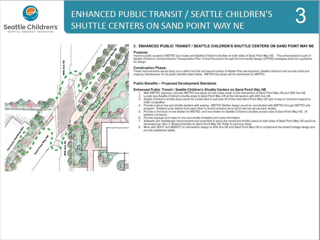
20 payment shall be made prior to the issuance of any construction permits for the first project constructed under each phase of the MIMP. The total payment of $2,000,000 shall be completed by the issuance of any construction permit for a project outlined in Phase 4 of the MIMP. Children s complied with this condition Children s has paid the full $500,000 for bike/pedestrian improvements associated with this phase of development. Guided by public input, the Seattle Children s Livable Streets Initiative identified a host of projects to improve bicycle and pedestrian safety in NE Seattle. Working with SDOT, Children s ranked this list and identified the most impactful projects. In the fall of 2012, the civil work for a 1.4 mile Greenway Seattle s second such facility was completed on 39 th Avenue NE. Also associated with this condition, in the Fall of 2012 Children s funded the completion of crossing improvements and enhancements to a bus stop on 40 th Ave NE and NE 50 th street. All bicycle and pedestrian improvements associated with this phase of development were completed in April Children s hosted, in June of 2014, a Livable Streets Initiative Celebration for the community highlighting the suite of improvements and encouraging their use by all ages and abilities by providing guided tours, free bicycle helmets and networking opportunities between residents and active transportation groups like Feet First, Cascade Bicycle Club Seattle Greenways, and others. In addition to the Council conditions, the following sections (Street Vacation Public Benefits, Street Vacation Approval Conditions, Design Guidelines, and Construction Management Plan summary) are provided for reference: STREET VACATION PUBLIC BENEFITS 1. BURKE-GILMAN TRAIL / SAND POINT WAY NE CONNECTION AT HARTMANN SITE Purpose: Provide 24 hour pedestrian and bicycle public access from the Burke-Gilman trail to Sand Point Way NE and across the proposed new intersection at 40th Ave NE and Sand Point Way NE. Trail connection to be designed to create a safe route for people of all abilities. Crime Prevention through Environmental Design (CPTED) strategies shall be a guideline for design. Children s developed this Burke Gilman Trail connection early (it was to be part of Phase 2) at the urging of the SAC. It is now complete, and the Property Use and Development document is pending with SDOT/City of Seattle. 2. STREET AMENITIES ON SAND POINT WAY NE Purpose: Provide plaza, street and sidewalk improvements for public access and use of Sand Point Way NE along the former Laurelon Terrace condominium (east side of Sand Point Way NE), and Hartmann (west side of Sand Point Way NE) properties. Crime Prevention through Environmental Design (CPTED) strategies shall be a guideline for design. Children has provided all of these items. 3. ENHANCED PUBLIC TRANSIT / SEATTLE CHILDREN S SHUTTLE CENTERS ON SAND POINT WAY NE Council MIMP Condition #35: Consistent with the Transportation Management Plan (TMP), onsite improvements shall include: a shuttle hub; an enhanced campus pathway to connect to transit along Sand Point Way Northeast and/or 40th Ave Northeast; and bicycle parking. Purpose: Improve public access to METRO bus routes and Seattle Children s shuttles on both sides of Sand Point Way NE. This enhancement is part of Seattle Children s Comprehensive Transportation Plan. Crime Prevention through Environmental Design (CPTED) strategies shall be a guideline for design. Children s has provided all of these items. 4. $2 MILLION FOR BIKE AND PEDESTRIAN FUND Council MIMP Condition #42: Children's shall pay the Seattle Department of Transportation (SDOT) a total of $2,000,000 for pedestrian and bicycle improvements in Northeast Seattle over the timeframe of the Master Plan
21 development. A pro-rata share payment shall be made prior to the issuance of any construction permits for the first project constructed under each phase of the MIMP. The total payment of $2,000,000 shall be completed by the issuance of any construction permit for a project outlined in Phase 4 of the MIMP. Purpose: To allow Seattle Department of Transportation (SDOT) to fund and develop unfunded priority pr ojects in Northeast Seattle, particularly those that are within 1.5 miles of Seattle Children s main campus, that promote safe biking and walking for the general public. Children s has provided all of these items. Construction Phase: Seattle Children s would pay into the Bike and Pedestrian Fund the amount of $5,715 for each of the 350 new beds added to the hospital pursuant to the proposed Master Plan. For example, for 100 beds, Seattle Children s would pay $571,500 into the fund. These contributions would be payable on or before the issuance of the certificate of occupancy for each phase of construction. For payments in Phases 2, 3 and 4, the amount of the payment per bed would be adjusted to account for changes in the Consumer Price Index All Urban Consumers, All Items, U.S. Averages published by the Bureau of Labor Statistics. Children s has provided all of these items. 5. STREET AMENITIES ON 40TH AVE NE Purpose: Provide plaza, street and sidewalk improvements for public access and use of 40th Ave NE along the former Laurelon Terrace Condominium from NE 45th Street to Sand Point Way NE that are less intensive than the plazas on Sand Point Way NE and, instead, serve as transition to the residential development on the west side of 40th Ave NE. Crime Prevention through Environmental Design (CPTED) strategies shall be a guideline for design. Children s has provided all of these items. 6. POCKET PARK AT CORNER OF 40TH AVE NE / NE 45TH STREET AND NE 45TH STREET EDGE Purpose: Provide public area of respite and a focal point at this transition area between the Laurelhurst neighborhood on the south and Seattle Children s future development. Crime Prevention through Environmental Design (CPTED) strategies shall be a guideline for design. Children s has provided all of these items. STREET VACATION APPROVAL CONDITIONS 1. The vacation is granted to allow the Petitioner to build a project substantially in conformity with the project presented to the City Council and for no other purpose. The project must be substantially in conformity with the proposal reviewed by the Transportation Committee in May of All street improvements shall be designed to City standards and be reviewed and approved by the Seattle Department of Transportation; elements of the street improvement plan and required street improvements to be reviewed include: * Street improvement plan showing sidewalks, street trees, lighting and landscaping around the site; * Proposed signal installations; and * Proposed pedestrian/bicycle trail connection from Sand Point Way NE to the Burke-Gilman Trail. 3. The utility issues shall be resolved to the full satisfaction of the affected utility prior to the approval of the final vacation ordinance. Prior to the commencement of any development activity on the site, the Petitioner shall work with the affected utilities and provide for the protection of the utility facilities. This may include easements, restrictive covenants, relocation agreements, or acquisition of the utilities, which shall be at the sole expense of the Petitioner. Utilities impacted include: * Seattle Public Utilities;
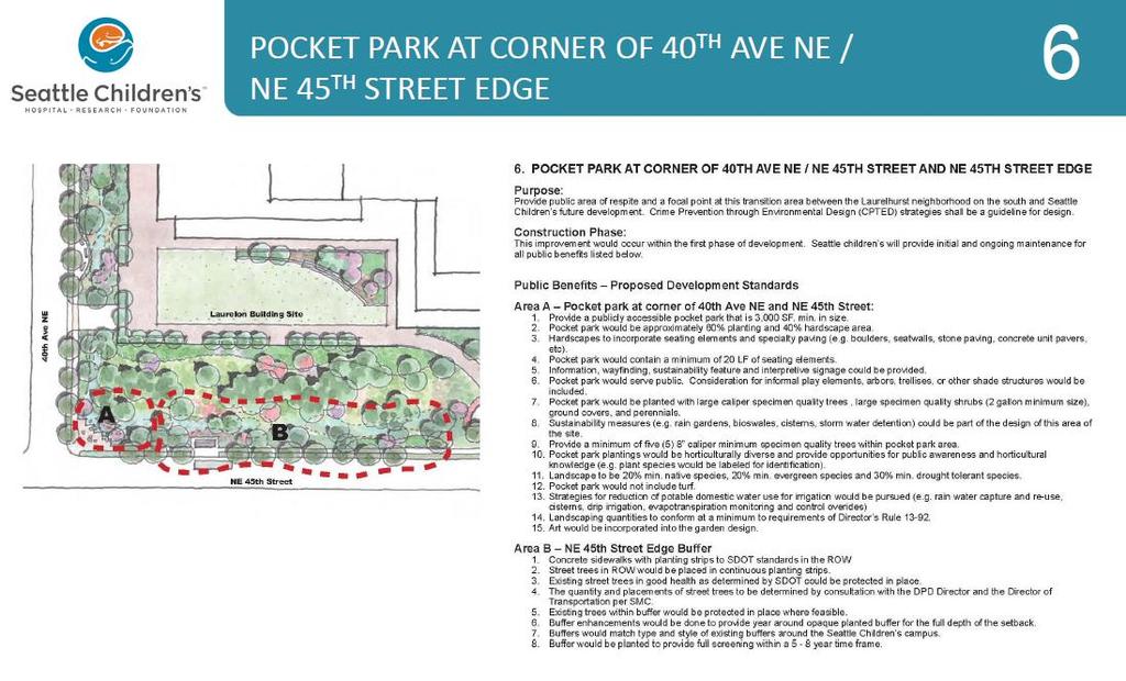
22 * Puget Sound Energy; * Seattle Department of Transportation; * Seattle City Light; and * Qwest Communications. 4. It is expected that development activity will commence within 18 months of this approval and the development activity will be completed within five years. If the vacation cannot be completed within five years, the Petitioner must request an extension of time from the Transportation Committee. In order to insure timely compliance with the conditions imposed by the City Council, the Petitioner shall provide Seattle Department of Transportation with Quarterly Reports, following Council approval of the vacation, providing an update on the development activity and schedule and the progress on meeting the conditions. The Petitioner shall not request or be issued a Certificate of Occupancy (C of O) for the project until SDOT has determined that all conditions have been satisfied and all fees have been paid. 5. In addition to the conditions imposed through the vacation process, the project, as it proceeds through the permitting process, is subject to SEPA review and to conditioning pursuant to various City codes and through regulatory review processes including SEPA. 6. The Petitioner shall develop and maintain the public benefit elements as defined by the City Council. A Property Use and Development Agreement (PUDA) or other binding mechanism shall be required to ensure that the public benefit elements remain open and accessible to the public and to outline future maintenance obligations of the improvements. Accountability for public benefit elements associated with later phases of development must also be outlined in the PUDA. The final design of the public benefit elements shall require the review and approval of SDOT and SDOT may request additional review by the Design Commission, if necessary. The public benefit requirement includes the following features as well as the corresponding proposed development standards: * Burke-Gilman Trail/Sand Point Way NE connection at Hartmann Site: The purpose of this public benefit is to provide 24-hour pedestrian and bicycle public access from the Burke-Gilman Trail to Sand Point Way NE and across the proposed new Intersection at 40th Avenue NE and Sand Point Way NE. The trail connection is to be designed to provide a safe route for people to access the 40th and Sand Pont Way NE intersection. Crime Prevention through Environmental Design (CPTED) strategies shall be a guideline for design for all of the public benefit elements. This connection would likely be constructed during the second phase of the Master Plan. * Street Amenities on Sand Point Way NE: The purpose of this public benefit is to provide plaza, street and sidewalk improvements for public access and the use of Sand Point Way NE along the former Laurelon Terrace (east side of Sand Point Way NE) and the Hartmann (west side of Sand Point Way NE) properties. These improvements would likely occur during the first two phases of development. * Enhanced Public Transit/Seattle Children's Shuttle Centers on Sand Point Way NE: The purpose of the enhancements is to improve public access to Metro bus routes and Children's shuttle on both sides of Sand Point Way NE. This enhancement is also part of Children's Transportation Plan. These improvements would likely occur during the first two phases of development. * $2 Million for Bicycle and Pedestrian Fund: The purpose of this is to allow SDOT to fund and develop unfunded priority projects in Northeast Seattle, particularly those that are within 1.5 miles of Children's main campus, that promote safe biking and walking for the general public. The goal is to have the money distributed as early as possible in the development process. * Street Amenities on 40th Avenue NE: The purpose is to provide plaza, street and sidewalk improvements for public access and use of 40th Avenue NE along the former Laurelon Terrace site from NE 45th Street to Sand Point Way NE that are less intensive than the plazas on Sand Point Way NE and instead serve as a transition to the residential development on the west side of 40th Avenue NE. These improvements would occur within the first phase of development. * Pocket Park at Corner of 40th Avenue NE/NE 45th Street and NE 45th Street Edge: The purpose of this public benefit is to provide a public area of respite and a focal point at this transition area between the Laurelhurst neighborhood on the south and Seattle Children's future development. This improvement would occur within the first phase of development.
23 7. Children's shall work with DPD and SDOT to coordinate implementation strategies for meeting the vacation and Master Plan conditions to insure full compliance with all conditions. DPD and SDOT may consider a joint PUDA or other documentation to consolidate all the project conditions. A copy of the final report is attached as an exhibit. DESIGN GUIDELINES B1.0 Site Design B1.1 Hospital Campus Character B1.1.2 General Guidelines Acknowledge the character of surrounding single-family residential, multi-family and mixed use areas at each edge. Use a compatible palette, texture, and color of building materials to unify the hospital campus. Use landscaping to soften and enhance outdoor spaces and screen utilities, blank walls and other more functional elements. B1.1.3 Street Frontage Edge Open spaces adjacent to Street Frontage Edges to be inviting, open and complementary to adjacent street frontage uses. Use a combination of the following architectural treatments to enhance front door Street Frontage Edges: architectural features and detailing such as railings and balustrades, awnings or canopies, decorative pavement, decorative lighting, seats, planter boxes, trellises, artwork, signs. B Public Entrances and Access Points Create a hierarchy of public entrances and access points to emphasize their appearance at Street Frontage Edge locations, and diminish them at Garden Edge locations where visible from single family residences. B Streetscape and Pedestrian Pathways Design streets and pathways to accommodate all travel modes. Streets, sidewalks and hospital campus pathways should be welcoming, open to the general public, as well as barrier-free and ADA-accessible. B Sidewalks Relate the sidewalk and its amenities to the adjacent uses, the organization of pedestrian movements, and the experience along its length. B Parking and Vehicle Access Minimize vehicle movement and storage and design facilities to complement the envisioned calming character of the campus. B1.1.4 Transition Edge Evaluate the Transition Edge against the same for Street Frontage Edge and Garden Edge guidelines and considerations. B1.1.5 Garden Edge The objective of the Garden Edge is to screen hospital structures and light that emanates from vehicles, buildings and site fixtures, while providing an aesthetically pleasing and diversely vegetated viewscape and safe walking environment for pedestrians. Architectural features, landscape improvements, and the transition zone between hospital buildings and the public right of way around Garden Edges shall be designed to be compatible with adjacent single family character.
24 Use a combination of the following treatments to ensure compatibility with adjacent uses: planted screens, gardens, plaza areas, decorative pavement, non-glare lighting, seating, planter boxes, trellises, artwork, and signage. B1.2 Exterior Spaces B1.2.2 General Guidelines Exterior spaces should extend the color, texture, pattern and quality of the surrounding residential areas. Exterior spaces shall provide a visually and otherwise calming experience. The hospital campus shall be designed to include and provide access to restorative and therapeutic gardens with seasonal sun and shade to provide outdoor comfort for families, patients, caregivers and neighbors. Similar materials in plantings, paving, stairs and walls to provide a unifying context for the site development which matches or complements existing campus and surrounding areas. Artwork integrated into publicly accessible areas of buildings and landscaping that evokes a sense of place related to the use of the area. Focal point features such as building entries, fountains, botanical gardens, therapy gardens or pools that relate to wayfinding or honors and memorials. B1.2.3 Retaining Wall Guidelines Retaining walls near a public sidewalk that extend higher than eye level should be avoided where possible. Where high retaining walls are unavoidable, they should be designed to reduce their visual impact and increase the interest for the pedestrian along the streetscape. B1.2.4 Screening Guidelines Where necessary, use screening sensitively to soften noise and visual impacts to adjacent properties. Design screening to minimize impact of noise producing equipment to adjacent residential neighborhoods. B1.2.5 Lighting, Safety and Security Guidelines The design and locations of physical features such as site furnishings, landscaping, pathways and lighting should maximize pedestrian visibility and safety while fostering positive social interaction among patients, visitors, caregivers and neighbors. B1.2.6 Artwork Guidelines Include opportunities for art in the design process as early as possible to allow integration into the design. Evaluate the suitability of artwork, whether commissioned or acquired, for its specific site. Consider the artwork s size, materials, concept, etc. B1.3 Landscape B1.3.2 General Guidelines The landscape plan shall respond to special on-site conditions such as steep slopes, existing significant trees - such as mature, rare or ornamental trees - as well as extend or improve off-site conditions, such as greenbelts, natural areas and streets. Coordinate plant locations with adjacent building functions. The landscape should extend the color, texture and pattern of the surrounding residential areas while maintaining the visually calming experience unique to the hospital campus. Focal point features such as building entries, fountains, botanical gardens, therapy gardens or pools that relate to wayfinding or honors and memorials. B1.3.3 Planting Guidelines Plantings shall include mix of groundcovers and perennials, shrubs, understory and canopy trees to provide multilayered interest. Plantings shall include deciduous and evergreen plants to provide multi-seasonal interest.
25 Plantings shall include some portion of hybridized or native plants which are drought tolerant and beneficial to native insects and birds. Avoid dense, dark vegetated walls along sidewalks by instead planting year-round screens that are softened by diverse and deciduous plantings and open spaces. Avoid planting low-branching shrubs and other potentially unsafe, view-obscuring plants close to sidewalks. To minimize need for irrigation beyond the establishment period, consider drought and urban tolerant plants. Supplemental planting types and densities to connect greenways and wildlife corridors. Existing plant materials mixed with new plant material to maximize longevity of both campus and r ight-of-way plant communities. B1.3.4 Stormwater Guideline Stormwater treatment and control integrated with the natural rain water cycle, grading and plant communities of the site. B1.3.5 Irrigation Guideline Mix of drought tolerant landscape plantings, reused stormwater, and drip irrigation to conserve potable water. B1.3.6 Steep Slope Guideline Plantings and other erosion control measures to prevent site destabilization on steep topography. B2.0 Architectural Character B2.1 Height, Bulk and Scale Design buildings with materials that help visually reduce the scale and form of the buildings into smaller scaled elements that complement neighboring structures within the same visual field. B2.2 Architectural Elements and Features Integrate new buildings with the existing architecture to establish a new cohesive whole for the campus. B2.3 Rooftops Where rooftops are visible from locations beyond the hospital campus, rooftops are a design element. B2.4 Finish Materials Design and build new buildings with high-quality, attractive, durable materials aesthetically appropriate to the hospital and the neighborhood. CONSTRUCTION MANAGEMENT PLAN I. Construction Communication (Plan work, reduce impacts, two-way communication) II. Construction Work Hours (7a-6p, noise after 8a) III. IV. Construction Noise and Vibration Management (Noise reduction management) Construction Milestones (Demo, excavation, shoring, concrete, steel) V. Construction Parking Management (Workers parking offsite and bussed to site - bus stays on site / trucks onsite) VI. Construction Traffic/Street and Sidewalk Closures (Per SDOT approval and as needed with flaggers)
26 II. Seattle City Council Transportation Committee Update (PDF)
27
28
29

30
31
32

33

34

35

36

37

38

39

40
41
42

43

44

45
46
47

48
49 III. Community Benefit Report

50 Caring for Our Community At Seattle Children s, we re always thinking of the health and well-being of every child, teen and family in the community. We reach beyond our hospital every day to provide programs and services to make children, teens and families safer and healthier where they live. Our commitment to caring for the community is our passion, our duty and our privilege Community Benefits We re proud to share our Community Benefit Report (PDF), which summarizes our activities in the community. Through our uncompensated care, health professional education, research and community programs and services, we provided more than $192 million in community benefit activities: $126,683,000 in uncompensated care $24,631,000 in health professions education $29,684,000 in research $11,520,000 in community programs and services Community Benefit and Advocacy Programs Our commitment to caring for the community is our passion, our duty, and our privilege. We advocate for children and their families and offer resources and services where they live. Access to Healthcare Adolescent Health o Seattle Children s Pre-Teen Classes o Prevention Works in Seattle Coordinated Care for Children with Chronic Conditions Injury Prevention o Car Seat Safety o Water Safety o Child Abuse Prevention
Gordon Clowers City of Seattle - Department of Planning and Development 700 Fifth Avenue, Suite 2000 PO Box Seattle, Washington
 Major Institution Master Plan Annual Report 2014 March 15, 2015 Gordon Clowers City of Seattle - Department of Planning and Development 700 Fifth Avenue, Suite 2000 PO Box 34019 Seattle, Washington 98124-4019
Proposed Major Institution Master Plan Street Vacation. March 19, 2009
 Presentation to Seattle Design Commission Proposed Major Institution Master Plan Street Vacation March 19, 2009 1 Why We Need to Grow More children surviving with chronic disease increasing the demand
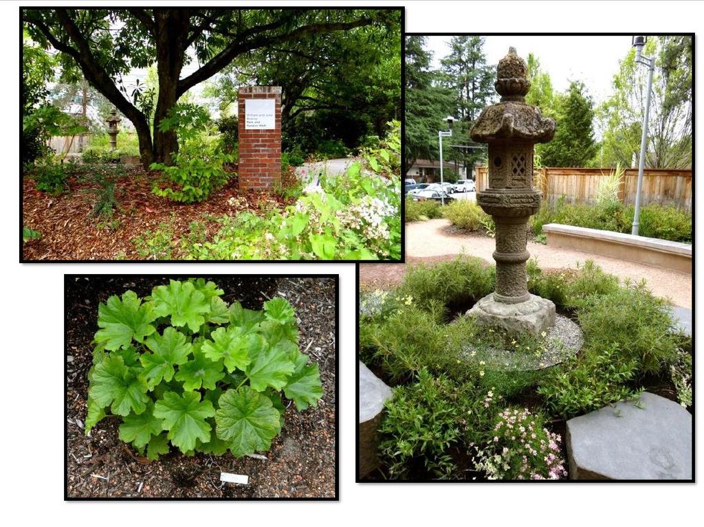
Garden edges provide vertical plantings to buffer the neighbors from the building facilities around the entire campus.
 Open Space Existing Open Space Children s intends to maintain the landscape as a garden around the campus to help children heal while providing spaces for visitors, caregivers, staff and neighbors. Children
IV. Development Standards
 IV. Development Standards Seattle Children s proposes development standards to govern physical development within the MIO boundaries. As a supplement to the proposed development standards, Children s proposes
Gold Line Bus Rapid Transit Transit Oriented Development (BRTOD) Helmo Station Area Plan
 Helmo Station Area Plan") Appendix F Gold Line Bus Rapid Transit Transit Oriented Development (BRTOD) Helmo Station Area Plan Introduction and Purpose of the Plan The Gold Line Bus Rapid Transit facility is an eleven-mile dedicated
Appendix F Gold Line Bus Rapid Transit Transit Oriented Development (BRTOD) Helmo Station Area Plan Introduction and Purpose of the Plan The Gold Line Bus Rapid Transit facility is an eleven-mile dedicated
Urban Planning and Land Use
 Urban Planning and Land Use 701 North 7 th Street, Room 423 Phone: (913) 573-5750 Kansas City, Kansas 66101 Fax: (913) 573-5796 Email: planninginfo@wycokck.org www.wycokck.org/planning To: From: City Planning
RESOLUTION NO. R Refining the route, profile and stations for the Downtown Redmond Link Extension
 RESOLUTION NO. R2018-32 Refining the route, profile and stations for the Downtown Redmond Link Extension MEETING: DATE: TYPE OF ACTION: STAFF CONTACT: Capital Committee Board PROPOSED ACTION 09/13/2018
The University District envisions, in its neighborhood
 Envisioning the University District Link Light Rail in Seattle s neighborhoods CIY OF SEALE CONCEP-LEVEL SAION AREA PLANNING RECOMMENDAION RESOLUION # 30165 EXHIBI L Vision 08.2000 he University District
Guiding Principles for the SR 520 Replacement Project
 Guiding Principles for the SR 520 Replacement Project Presentation to the Board of Regents Theresa Doherty Assistant Vice President for Regional Affairs May 18, 2006 F-14 The University of Washington is
SEATTLE PACIFIC UNIVERSITY MIMP Condition Status Matrix: July 1, 2015 June 30, 2016
 SEATTLE PACIFIC UNIVERSITY MIMP Condition Status Matrix: July 1, 2015 June 30, 2016 # CITY COUNCIL CONDITION FULFILLED/ 1 Modify the MIMP to replace the last sentence of the first paragraph on page 43
CITY OF SEATTLE ANALYSIS, RECOMMENDATION AND DETERMINATION OF THE DIRECTOR OF THE DEPARTMENT OF PLANNING AND DEVELOPMENT. Seattle Children s Hospital
 City of Seattle Gregory J Nickels, Mayor Department of Planning and Development Diane Sugimura, Director CITY OF SEATTLE ANALYSIS, RECOMMENDATION AND DETERMINATION OF THE DIRECTOR OF THE DEPARTMENT OF
Transit Oriented Development. Overview
 Trammell Crow Residential Sean G. Hyatt, Managing Director Transit Oriented Development What is TOD? TOD in King County TOD Characteristics and Examples Veloce (Alexan Redmond TOD) About Trammell Crow
SDOT DPD. SDOT Director s Rule DPD Director s Rule DCLU DR SED DR of 7 CITY OF SEATTLE
 SDOT SDOT Director s Rule 2-07 DPD Applicant: CITY OF SEATTLE Page 1 of 7 Supersedes: DCLU DR 11-93 SED DR 93-4 Seattle Department of Transportation (SDOT) Department of Planning and Development (DPD)
CHAPTER 7: Transportation, Mobility and Circulation
 AGLE AREA COMMUNITY Plan CHAPTER 7 CHAPTER 7: Transportation, Mobility and Circulation Transportation, Mobility and Circulation The purpose of the Transportation, Mobility and Circulation Chapter is to
This Review Is Divided Into Two Phases:
 Semiahmoo Town Centre Review The purpose of this review: To review the Semiahmoo Town Centre Concept Plan, originally approved in 1993, to ensure that this centre will continue to serve the needs of South
Proposed Comprehensive Plan Strategies DRAFT for discussion June 28, 2017
 Proposed Comprehensive Plan Strategies DRAFT for discussion June 28, 2017 Land Use Rural Areas Refine the Farm and Forest area (FF) Update FF boundaries to account for existing lots less than five acres
MONTGOMERY COUNTY PLANNING DEPARTMENT
 MONTGOMERY COUNTY PLANNING DEPARTMENT THE MARYLAND-NATIONAL CAPITAL PARK AND PLANNING COMMISSION MCPB Item No.: Date: 5-03-18 Pike and Rose, Phase I: Site Plan Amendment No. 82012002D Rhoda Hersson-Ringskog,
Silverdale Regional Center
 Silverdale Regional Center Vision for Silverdale Regional Center The Silverdale Regional Center Plan (Plan) will guide the evolution of the Silverdale Regional Center from a collection of strip malls and
Transportation. Strategies for Action
 Transportation A major priority for the Overlake Neighborhood is to develop a multimodal transportation system. To achieve this system, a balance has to be found among travel, circulation and access needs;
CHARLES PUTMAN CHARLES PUTMAN AND ASSOCIATES, INC
 MEMORANDUM CHARLES PUTMAN & ASSOCIATES, INC. LAND DEVELOPMENT CONSULTANTS PLANNING ZONING PERMITTING 4722 NW Boca Raton Boulevard, Suite C-106 Boca Raton, Florida 33431 Phone: 561/994-6411 FAX: 561/994-0447
TRANSPORTATION ELEMENT GOALS, OBJECTIVES, AND POLICIES
 TRANSPORTATION ELEMENT GOALS, OBJECTIVES, AND POLICIES GOAL 2 The City shall provide a safe, convenient, effective, and energy efficient multimodal transportation system which is coordinated with the Future
UNIVERSITY OF WASHINGTON Mercer Hall Project, Terry/Lander Hall Project, and Development Capacity Re-allocation from Central to West Campus
 UNIVERSITY OF WASHINGTON Mercer Hall Project, Terry/Lander Hall Project, and Development Capacity Re-allocation from Central to West Campus EIS ADDENDUM UNIVERSITY OF WASHINGTON May 25, 2011 EIS Addendum
117 E. Louisa St. #1 Seattle, WA January 29, 2016
 Alison Townsend, Strategic Advisor Seattle Department of Transportation P.O. Box 34996 Seattle, WA 98124-4996 Dear Ms. Townsend: 117 E. Louisa St. #1 Seattle, WA 98102-3278 January 29, 2016 The Eastlake
University of the District of Columbia Van Ness Campus Master Plan Community Open House 3. December 8, 2010
 University of the District of Columbia Van Ness Campus Master Plan Open House 3 December 8, 2010 Introductions Sequence of Work: Campus Master Plan BEGIN: INTRODUCE AND START WORK Project Initiation Team
Welcome to the Oakridge Centre Open House
 Welcome to the Oakridge Centre Open House Why is the City hosting this event? This open house is to inform you of a rezoning application submitted to the City of Vancouver to amend the existing CD-1 (Comprehensive
Mobility Districts and Traffic Studies
 Mobility Districts and Traffic Studies During the last Comprehensive Plan update in 2008, the City of Sarasota identified the need to develop a citywide strategy for enhancing the mobility options of all
MONTGOMERY COUNTY METRO STATION AREA DESIGN CHARRETTE
 MONTGOMERY COUNTY METRO STATION AREA DESIGN CHARRETTE Shady Grove Metro Station Area Charrette Closing Presentation October 25-28, 2000 MONTGOMERY COUNTY, MD M-NCPPC Design Collective, Inc. Architects
Developer s Program. The Station at East 54
 Developer s Program The Station at East 54 Existing Conditions The Station at East 54 is proposed for a 1.12 acre site at the northeast corner of Hamilton Road and Prestwick Road, tucked between the East
Glenborough at Easton Land Use Master Plan
 Implementation 114 9.0 IMPLEMENTATION 9.1 OVERVIEW This chapter summarizes the administrative procedures necessary to implement the proposed land use plan, infrastructure improvements, development standards,
DRAFT Amsterdam/Churchill Community Plan (4/17/08) Adopted By the Gallatin County Commission
 Adopted By the Gallatin County Commission") DRAFT Amsterdam/Churchill Community Plan (4/17/08) Adopted By the Gallatin County Commission Table of Contents Acknowledgements Chapter 1: Introduction A Brief History What s Next Authority Organization
DRAFT Amsterdam/Churchill Community Plan (4/17/08) Adopted By the Gallatin County Commission Table of Contents Acknowledgements Chapter 1: Introduction A Brief History What s Next Authority Organization
Promoting Economic Development Through Upfront SEPA Review: Lessons from South Downtown Tacoma
 Promoting Economic Development Through Upfront SEPA Review: Lessons from South Downtown Tacoma 1 This session will focus on the City of Tacoma s South Downtown Subarea Plan and associated Non-Project SEPA
Today Land & People. Northeast Nampa Gateway District. Employment. Land Use Characteristics. Demographics. Current Zoning
 Today Land & People Employment Major employers include Saint Alphonsus, the College of Western Idaho, the Auto Mall, Sorrento Lactalis and Walmart. 3,004 jobs in 2010 (COMPASS-CIM 2040 TAZ data) 4,345
Shift Rapid Transit Public Participation Meeting May 3, 2017
 Shift Rapid Transit Public Participation Meeting May 3, 2017 Shift Rapid Transit Initiative Largest infrastructure project in the city s history. Rapid Transit initiative will transform London s public
The subject site plan amendment proposes the following revisions to the approved site plan:
 PROPOSED AMENDMENT The subject site plan amendment proposes the following revisions to the approved site plan: 1. The building footprint was modified to accommodate the revised architectural design. 2.
Institutional Overlay Zone (IOZ) Regulatory Framework
 Regulatory Framework") Institutional Overlay Zone (IOZ) Regulatory Framework Approved by Portland City Council November 20, 2017 APPLICABILITY All development proposed by Maine Medical Center (MMC) within the boundary of the
Institutional Overlay Zone (IOZ) Regulatory Framework Approved by Portland City Council November 20, 2017 APPLICABILITY All development proposed by Maine Medical Center (MMC) within the boundary of the
Public input has been an important part of the plan development process.
 Lakewood s Comprehensive Plan recognizes that transportation helps shape the community, and that the way the community provides for the safe and efficient movement of people affects the character of the
PLAN ELEMENTS WORKSHOP. April 5, 2016
 PLAN ELEMENTS WORKSHOP April 5, 2016 needs more housing. But there is no one-size fits-all solution. Every neighborhood has its own character. In some places, density is not only appropriate it is badly
Ashland BRT Environmental Assessment: logos of CTA, CDOT, Chicago Department of Housing and Economic Development
 Ashland BRT Environmental Assessment: logos of CTA, CDOT, Chicago Department of Housing and Economic Development Overview The Chicago Transit Authority (CTA), in partnership with the Chicago Department
Planned Development Review Revisions (Project No. PLNPCM )
") Planned Development Review Revisions (Project No. PLNPCM2014-00139) Standard residential development Planned Development Example: Smaller lot sizes than what is allowed to create open space amenity. What
Planned Development Review Revisions (Project No. PLNPCM2014-00139) Standard residential development Planned Development Example: Smaller lot sizes than what is allowed to create open space amenity. What
Sound Transit 3. Appendix A: Detailed Description of Facilities and Estimated Costs
 Sound Transit 3 Appendix A: Detailed Description of Facilities and Estimated Costs Table of Contents Sound Transit 3 Plan Map... 3 Total agency: Projects... 4 Total agency: Sources and uses of funds...
KEIZER STATION PLAN INTRODUCTION
 KEIZER STATION PLAN INTRODUCTION Planning for this area began in 1987 when the Keizer Comprehensive Plan established the Chemawa Activity Center and McNary Activity Center. The first Chemawa Activity Center
Metro. Activity Center Design Guidelines. Recommendations For Developing Focused, Mixed-Use Commercial/Residential Centers
 Metro Activity Center Design Guidelines Recommendations For Developing Focused, Mixed-Use Commercial/Residential Centers Metro Activity Centers What is a MAC? Legacy, the adopted guide for the future growth
ELMVALE ACRES SHOPPING CENTRE MASTER PLAN
 ELMVALE ACRES SHOPPING CENTRE MASTER PLAN Contents 1.0 INTRODUCTION... 2 2.0 LOCATION... 2 3.0 EXISTING CONTEXT... 2 4.0 VISION & GUIDING PRINCIPLES... 2 5.0 LAND USE AND BUILT FORM... 4 5.1 St. Laurent
3. VISION AND GOALS. Vision Statement. Goals, Objectives and Policies
 Vision Statement Queen Creek s interconnected network of parks, trails, open spaces and recreation opportunities provide safe and diverse activities and programs that sustain its unique, small town, equestrian
What s Up Next In The Seattle Squeeze. PSRC Transportation Policy Board April 11
 What s Up Next In The Seattle Squeeze PSRC Transportation Policy Board April 11 1 Current construction Alaskan Way Viaduct removal Removes the viaduct (including foundations and ramps) and restores the
Chapter 22. Alternatives to the Proposed Project
 Page 22-1 Chapter 22. Alternatives to the Proposed Project Introduction This chapter assesses the potential environmental effects of alternatives to the Proposed Project. The alternatives analyzed include
38 Queen s University Campus Master Plan Part 1
 38 Queen s University Campus Master Plan Part 1 46 The Campus at the City Scale Chapter 4 The Campus at the City Scale 39 Queen s is an urban University centrally located in Kingston. Decisions made by
9 CITY OF VAUGHAN OFFICIAL PLAN AMENDMENT NO BOCA EAST INVESTMENTS LIMITED
 9 CITY OF VAUGHAN OFFICIAL PLAN AMENDMENT NO. 631 - BOCA EAST INVESTMENTS LIMITED The Planning and Economic Development Committee recommends the adoption of the recommendations contained in the following
City Of Sparks Planning Commission Item
 Page 1 of 12 City Of Sparks Planning Commission Item Meeting Date: May17, 2012 Subject: PCN12009, Public Hearing, Consideration and possible action on a Master Plan Amendment and Rezoning request to change
UCSF Parnassus Heights Re-Envisioning Process
 UCSF Parnassus Heights Re-Envisioning Process Community Working Group Meeting #5 February 27, 2019 Agenda Welcome, Introductions, Agenda Overview, and Review of Last Meeting Summary of Community Ideas
Community Meeting of May 19, Meeting the Challenge
 Community Meeting of May 19, 2007 Meeting the Challenge Case Study Case Study: Bellevue Regional Library Case Study Case Study: Fred Hutchinson Cancer Research Case Study Case Study: Dorenbecher Children
RECREATION AND OPEN SPACE ELEMENT GOALS, OBJECTIVES, AND POLICIES
 RECREATION AND OPEN SPACE ELEMENT GOALS, OBJECTIVES, AND POLICIES Goal 7 To provide park facilities, recreation programs, and open space resources that are safe, adequate, and accessible to all City residents,
REPORT TO PLANNING COMMISSION
 CITY OF Meeting Date: October 25, 2011 Agenda Item: Community Development Department Planning Division P. O. Box 151560, San Rafael, CA 94915-1560 PHONE: (415) 485-3085/FAX: (415) 485-3184 Case Numbers:
Executive Summary. NY 7 / NY 2 Corridor
 Executive Summary NY 7 / NY 2 Corridor Transportation and Land Use Study December 2005 Prepared for: Town of Colonie Capital District Transportation Committee Prepared by: Introduction: Land use decisions
DRAFT Civic Center Station Area Plan. Executive Summary
 DRAFT Civic Center Station Area Plan Executive Summary This project is funded in part through the Metropolitan Transportation Commission s Station Area Planning Program. The preparation of this report
FUTURE LAND USE ELEMENT
 FUTURE LAND USE ELEMENT GOAL I: To create and sustain a great place to live, play, and prosper Objective 1: The City of Ocala shall incorporate the principles and strategies of the Ocala 2035 Vision into
Description. Summary. MCPB Item No. Date: 01/17/13. Bethesda Crescent, Limited Site Plan Amendment, A, A
 THE MARYLAND-NATIONAL CAPITAL PARK AND PLANNING COMMISSION MCPB Item No. Date: 01/17/13 Bethesda Crescent, Limited Site Plan Amendment, 81984005A, 81984003A Parag Agrawal, Senior Planner, parag.agrawal@montgomeryplanning.org,
DEPARTMENT OF COMMUNITY DEVELOPMENT SERVICES Planning Division m e m o r a n d u m
 DEPARTMENT OF COMMUNITY DEVELOPMENT SERVICES Planning Division m e m o r a n d u m TO: Urbana Plan Commission FROM: Kevin Garcia, Planner II DATE: October 6, 2017 SUBJECT: Plan Case Nos. 2314-PUD-17 and
Chapter Master Planned Communities (MPC) District
 District") Sections 14.53.010 Purpose and Intent 14.53.020 Applicability 14.53.030 Procedure 14.53.040 MPC Standards 14.53.050 Required Findings 14.53.010 Purpose and Intent Chapter 14.53 Master Planned Communities
Sections 14.53.010 Purpose and Intent 14.53.020 Applicability 14.53.030 Procedure 14.53.040 MPC Standards 14.53.050 Required Findings 14.53.010 Purpose and Intent Chapter 14.53 Master Planned Communities
2.7 ac park. TOTAL 5,403 DU 1,297,900 sf 1,105,450 sf 3.87 ac 5,563 DU 1,121,200 sf 1,105,450 sf 3.87 ac
 PLAN AMENDMENT 2013-I-B1: SEVEN CORNERS SPECIAL STUDY Summary of Pre-staffing Comments Planner: Bernard Suchicital bsuchi@fairfaxcounty.gov (703) 324-1254 Background On October 29, 2013, the Board of Supervisors
UAA School of Engineering Parking Garage Master Plan Amendment. 1. Purpose
 UAA School of Engineering Parking Garage Master Plan Amendment 1. Purpose Since the UAA campus master plan was drafted in 2003, adopted in 2004, and amended in 2009 a number of significant changes regarding
EXISTING COMPREHENSIVE PLAN
 EXISTING COMPREHENSIVE PLAN Town Center Land Use Element: V. LAND USE POLICIES Town Center Mercer Island's business district vision as described in "Your Mercer Island Citizen-Designed Downtown" was an
Access to the University of North Carolina at Chapel Hill, UNC Hospitals, and Chapel Hill Transit.
 M 1/ 4 1/ 2 E IL M E IL Station Family: County: City: UNC Hospitals WHY THIS STATION? University Village Orange Chapel Hill Access to the University of North Carolina at Chapel Hill, UNC Hospitals, and
ESTABLISH AN EFFICIENT TOWN CENTER
 ESTABLISH AN EFFICIENT TOWN CENTER 4 Overview Lisbon residents are proud of the history of Newent and at the same time recognize its current importance as a centralized location for a variety of municipal
SCARBOROUGH SUBWAY EXTENSION. Scarborough Subway Extension. Final Terms of Reference
 Scarborough Subway Extension Final Terms of Reference 1 1.0 Introduction and Background 1.1 Introduction Toronto City Council recently confirmed support for an extension of the Bloor-Danforth Subway from
12/9/2013. HOLLYWOOD/PINES CORRIDOR PROJECT AMPO 2013 Annual Conference October 24, Our Perspective. Broward.
 HOLLYWOOD/PINES CORRIDOR PROJECT AMPO 2013 Annual Conference October 24, 2013 Our Perspective Broward Fort Lauderdale 1 Broward Metropolitan Planning Organization Fort Lauderdale Fort Lauderdale Skyline
Request Modification of Conditions of a Conditional Use Permit approved October 14, Staff Recommendation Approval. Staff Planner Stephen White
 Applicant Property Owner Public Hearing September 13, 2017 City Council Election District Lynnhaven Agenda Item 3 Request Modification of Conditions of a Conditional Use Permit approved October 14, 2003.
Town Center (part of the Comprehensive Plan)
") Town Center (part of the Comprehensive Plan) Mercer Island Town Center Looking North (2014) In 1994, a year-long process culminated in a set of design guidelines and code requirements for the Town Center
Town Center (part of the Comprehensive Plan) Mercer Island Town Center Looking North (2014) In 1994, a year-long process culminated in a set of design guidelines and code requirements for the Town Center
CITY OF PUYALLUP. Background. Development Services
 CITY OF PUYALLUP Development Services 333 South Meridian Puyallup WA 98371 To: City Council From: Katie Baker, AICP, Planning Division Re: South Hill Neighborhood Plan Adoption Date: (Meeting date: February
South Davis County COMMUNITY SPOTLIGHT
 South Davis County COMMUNITY SPOTLIGHT Davis/SLC Community Connector Bus Rapid Transit line connecting SLC & Davis County RTP Phase 1 Project Generate 3,100 average weekday riders Relieve congestion on
AMEND DMENT H HOSPITAL
 AMEND DMENT TO LAND USE PLAN ELEMENT VILLAGE OF RIDGEWOOD MASTER PLAN H HOSPITAL ZONE DISTRICT Village of Ridgewood Planning Board February 28, 2014with technical revisions from June 9, 2014 Planning Board
July 12, Columbus City Council City Hall 90 West Broad Street Columbus, OH RE: I-70/71 Columbus Crossroads Project
 OHIO DEPARTMENT OF TRANSPORTATION DISTRICT 6 400 EAST WILLIAM STREET DELAWARE, OHIO 43015 800.372.7714 Columbus City Council City Hall 90 West Broad Street Columbus, OH 43215-9015 RE: I-70/71 Columbus
Planning Board Briefing
 Planning Board Briefing Why Now? The Sector Plan Implementation Chapter States: Before Stage 1 begins, the following must occur: Approval of the Sectional Map Amendment. Approval of the Greater Lyttonsville
UNIVERSITY OF WASHINGTON MASTER PLAN SEATTLE CAMPUS
 UNIVERSITY OF WASHINGTON MASTER PLAN SEATTLE CAMPUS Approved Compiled Plan January 2003 Appoved Compiled Plan Janauary 2003 Table of Contents I. Introduction 1 The Visioning Project 3 1998 City University
DRAFT Northeast Quadrant of Kipling Avenue and Highway 7 DRAFT AUGUST 29, Goals Land Use. The goals of this Plan are to:
 AUGUST 29, 2017 12.15 Northeast Quadrant of Kipling Avenue and Highway 7 12.15.1 Goals 12.15.2 Land Use The goals of this Plan are to: 12.15.2.1 General Provisions: a) Ensure the development of a compact
STAFF SUMMARY FOR S17-02 SPECIAL USE PERMIT APPLICATION
 APPLICATION SUMMARY Case Number: S17-02 Request: STAFF SUMMARY FOR S17-02 SPECIAL USE PERMIT APPLICATION SUP application in order to develop a convenience food store. Applicant: Property Owner(s): Cindee
PROJECT BACKGROUND. Preliminary Design Scope and Tasks
 PROJECT BACKGROUND Preliminary Design Scope and Tasks The purpose of this Study is the development of preliminary designs for intersection improvements for Trunk Highway (TH) 36 at the intersections of
Introduction. Chapter 1. Purpose of the Comprehensive Plan Plan Organization Planning Process & Community Input 1-1
 Chapter 1 Introduction Lakewood 2025: Moving Forward Together Purpose of the Comprehensive Plan Plan Organization Planning Process & Community Input 1-1 Purpose of the Comprehensive Plan The Comprehensive
SUBJECT: Waterfront Hotel Planning Study Update TO: Planning and Development Committee FROM: Department of City Building. Recommendation: Purpose:
 Page 1 of Report PB-23-18 SUBJECT: Waterfront Hotel Planning Study Update TO: Planning and Development Committee FROM: Department of City Building Report Number: PB-23-18 Wards Affected: 2 File Numbers:
ULI St. Louis Technical Assistance Panel
 ULI St. Louis Technical Assistance Panel ULI St. Louis Technical Assistance Panel Sponsored by: Citizens for Modern Transit in partnership with METRO ULI St. Louis Mission Statement The mission of the
Bloor St. W. Rezoning - Preliminary Report
 STAFF REPORT ACTION REQUIRED 1638-1644 Bloor St. W. Rezoning - Preliminary Report Date: April 1, 2008 To: From: Wards: Reference Number: Toronto and East York Community Council Acting Director, Community
Public may provide comments on the GDP within the next two weeks (December 24)
") 25/70 General Development Plan (GDP) Public Meeting Wednesday, December 10, 2014 6:00 8:00 P.M. District 1 Police Station Community Room 1311 W 46th Ave, Denver, CO 80211 Council Woman Montero: This particular
25/70 General Development Plan (GDP) Public Meeting Wednesday, December 10, 2014 6:00 8:00 P.M. District 1 Police Station Community Room 1311 W 46th Ave, Denver, CO 80211 Council Woman Montero: This particular
From: Sent: To: Subject: Zoning: Landscaping:
 From: Bernard H. Berne [mailto:bhberne@yahoo.com] Sent: Tuesday, May 15, 2012 1:18 AM To: CountyBoard Subject: May 19, 2012 County Board Meeting: Goodyear Site Plan (SP #72-650 N. Glebe Road) and amendment
Incentive Zoning Regulations Florida Municipal City of Orlando
 Topic: Resource Type: State: Jurisdiction Type: Municipality: Year (adopted, written, etc.): 2002 Community Type applicable to: Title: Incentive Zoning Regulations Florida Municipal City of Orlando Document
CITY OF VAUGHAN EXTRACT FROM COUNCIL MEETING MINUTES OF MAY 27, 2014
 CITY OF VAUGHAN EXTRACT FROM COUNCIL MEETING MINUTES OF MAY 27, 2014 Item 6, Report No. 21, of the Committee of the Whole, which was adopted without amendment by the Council of the City of Vaughan on May
TOWN COUNCIL / PLANNING COMMISSION
 Workshop #3 TOWN COUNCIL / PLANNING COMMISSION January 20, 2011 Consultant Team In Attendance Tonight BMS Design Group Nevada City and San Francisco Michael Smiley, AICP, ASLA Partner-in-Charge Nancy L.
REGIONAL ACTIVITY CENTER
 DRAFT REGIONAL ACTIVITY CENTER 70 EAST BENCH MASTER PLAN DRAFT 06 Introduction The East Bench Regional Activity center is comprised of large educational, research, medical, and employment centers. These
6. REGIONAL AND COMMUNITY FACILITIES DESIGNATIONS 6.1. OBJECTIVES FOR REGIONAL AND COMMUNITY FACILITIES LAND USE DESIGNATIONS
 6. REGIONAL AND COMMUNITY FACILITIES DESIGNATIONS INTRODUCTION The Regional and land use designations provide the primary locations for uses which satisfy the health, education and other service needs
Policies and Code Intent Sections Related to Town Center
 Policies and Code Intent Sections Related to Town Center The Town Center Vision is scattered throughout the Comprehensive Plan, development code and the 1994 Town Center Plan. What follows are sections
Redevelopment of Ajax Plaza Area Public Open House Meeting February 19, 2015 Questions and Answers
 Redevelopment of Ajax Plaza Area Public Open House Meeting February 19, 2015 Questions and Answers Redevelopment of Ajax Plaza Area Why is the redevelopment of the Ajax Plaza important to the revitalization
Midtown Greenway Land Use and Development Plan Executive Summary
 Midtown Greenway Land Use and Development Plan Executive Summary Introduction The Midtown Greenway Land Use and Development Plan sets policy direction for land use and development in the Midtown Greenway
Rezoning Petition Final Staff Analysis June 18, 2018
 Rezoning Petition 2018-028 Final Staff Analysis June 18, 2018 REQUEST Current Zoning: MX-1 LLWPA (mixed use district, Lower Lake Wylie Protected Area), R-3 LLWPA (single family residential, Lower Lake
BACKGROUND / DETAILS OF PROPOSAL
 8 APPLICANT AND OWNER: MISSION ENTERPRISES, L.L.C STAFF PLANNER: Kristine Gay REQUEST: Conditional Use Permit ( Eating and Drinking Establishment within 100 of Protected District ) ADDRESS / DESCRIPTION:
LEED-ND 101: Practical Strategies for Achieving Sustainability Goals. Travis Parker Lakewood Planning Director
 LEED-ND 101: Practical Strategies for Achieving Sustainability Goals Travis Parker Lakewood Planning Director Metro Vision Idea Exchange Oct 11, 2012 West Corridor Stations West Corridor Overview West
Midtown Greenway PROJECT REPORT CARD
 Midtown Greenway PROJECT REPORT CARD Project Overview and History The Midtown Greenway is a 5.5-mile multi-use trail that connects the Mississippi River to the Minneapolis Chain of Lakes. The corridor,
PLNPCM Carl s Jr. Commercial Parking Lot at Redwood Road and 1700 South
 Staff Report PLANNING DIVISION COMMUNITY & NEIGHBORHOODS To: Salt Lake City Planning Commission From: Casey Stewart; 801-535-6260 Date: November 4, 2016 Re: PLNPCM2015-00874 Carl s Jr. Commercial Parking
TREASURE COAST REGIONAL PLANNING COUNCIL M E M O R A N D U M. To: Council Members AGENDA ITEM 5H
 TREASURE COAST REGIONAL PLANNING COUNCIL M E M O R A N D U M To: Council Members AGENDA ITEM 5H From: Date: Subject: Staff October 17, 2008 Council Meeting Local Government Comprehensive Plan Review Draft
Future Proposed Development
 Future Proposed Development on and around Link light rail s Capitol Hill Station Meeting September 24, 2012 Tonight s Agenda 6:00 pm Open House 6:30 pm Introductions Richard Conlin, City of Seattle Councilmember/Sound
greenprint midtown SUSTAINABILITY ACTION PLAN 2012
 greenprint midtown SUSTAINABILITY ACTION PLAN 2012 MIDTOWN ALLIANCE SOUTHFACE ENERGY INSTITUTE RENAISSANCE PLANNING GROUP SUSTAINABLE ATLANTA PERKINS+WILL 2 GREENPRINT MIDTOWN 1. Introduction Sustainability
Figure 1- Site Plan Concept
 Figure 1- Site Plan Concept Parking will be provided underground on three levels at rate of 1.0 space/ unit; this rate includes all visitors parking. MMM Group has prepared a parking assessment (April,