D.7 Segment B/C Least Harm Analysis
|
|
|
- Tyrone Adams
- 5 years ago
- Views:
Transcription
1 Appendix D Section 4(f)/6(f) Supplemental Evaluation D.7 Segment B/C Least Harm Analysis D.7.1 Introduction to Least Harm Analysis As discussed in Section D.6.1.3, as there is no prudent and feasible alternative to avoid the Mercer Slough Nature Park, pursuant to 23 CFR 774.3(c), a Least Harm analysis is provided here. As concluded in Section D.6, since alternatives from Segments B and C are not independent, and selecting an alternative in one of these segments would affect the range of alternatives in the other, these two segments cannot be reviewed separately, as other segments can. Therefore, Segments B and C are treated together and alternatives within these segments are combined for purposes of this least harm analysis. A project alternative as defined in his analysis may consist of an individual alternative within either Segment B or Segment C, or a combined Segment B and Segment C alternative such as Preferred Alternatives C9T-B2M and C11A-B2M. D.7.2 Range of Segment B and C Alternatives The range of feasible and prudent alternatives in Segments B and C consists of the complete set of possible combinations of the feasible and prudent Segment C alternatives with the set of feasible and prudent Segment B alternatives. There are a few alternatives that are not analyzed as combinations in the East Link Final EIS because their impacts are covered by other alternative combinations. However, all possible combinations are analyzed here with additional combinations, including those that are based upon the Preferred Alternatives C11A and C9T alternatives that connect with Alternatives B2A and B2E. This results in 35 B-C combination alternatives that must be considered, as illustrated in Exhibit D-25 and listed in Table D-7. D.7.3 Outline of Analysis of Least Harm as Required by FTA Regulations In Segments B and C, there is no prudent and feasible alternative that avoids any use of Section 4(f) resources. Therefore, pursuant to 23 CFR 774.3(c), the FTA may approve only the alternative that causes the least overall harm in light of the purposes of Section 4(f). The regulations require that determining which alternative causes the least overall harm be based upon an assessment and balancing of seven factors: 1. The ability of the alternative to mitigate adverse impacts to each Section 4(f) property (including any measures that result in benefits to the property) 2. The relative severity of the remaining harm, after mitigation, to the protected activities, attributes, or features that quality each Section 4(f) property for protection 3. The relative significance of each Section 4(f) property 4. The views of the official(s) with jurisdiction over each Section 4(f) property 5. The degree to which each alternative meets the purpose and need for the project 6. After reasonable mitigation, the magnitude of any adverse impacts to resources not protected by Section 4(f) 7. Substantial differences in costs among the alternatives There are five resources that have a Section 4(f) use and must be considered in this least harm analysis: Mercer Slough Nature Park, Surrey Downs Park, NE 2nd Pocket Parks, McCormick Park, and the Winters House. All five resources are considered under each of the seven balancing factors below. D.7.4 Factor 1: The Ability of the Alternative to Mitigate Adverse Impacts to Each Section 4(f) Property (including any measures that result in benefits to the property) This factor requires an analysis of how the effects of each alternative can be mitigated for each of the five Section 4(f) resources. Table D-8 summarizes the impacts that would occur and mitigation measures that have been proposed as a result of consultation with the appropriate resource managers, including the City of Bellevue and Washington State DAHP; the proposed mitigation is further discussed below by resource. Almost all effects on Section 4(f) resources can be mitigated, and some alternatives would result in a net benefit to the resource after mitigation. In addition to the ability to mitigate effects on Section 4(f) resources, several alternatives along Main Street in Downtown Bellevue could help facilitate the creation of a vegetated open green space that might support the City of Bellevue s park plan to create a buffer along Main Street for the Surrey Downs Neighborhood (City of Bellevue, 2010). This benefit would result from Alternatives C11A-B2M, C11A-B2A, C11A-B2E, C11A-B3, C11A-B7, C9T-B2M, C9T-B2A, C9T-B2E, C9T-B3, C9T-B7, C2T-B2E, C2T-B3, C2T-B7, East Link Project Final EIS D-43 July 2011

2 Appendix D Section 4(f)/6(f) Supplemental Evaluation EXHIBIT D-25 Range of Segment B-C Alternatives D-44 East Link Project Final EIS July 2011
3 Appendix D Section 4(f)/6(f) Supplemental Evaluation TABLE D-7 Range of Alternatives Evaluated under the Least Harm Analysis Nomenclature for the Segment C Alternatives Connection with Segment B Alternatives No. Least Harm Analysis 1 112th SE Modified Alternative (B2M) to C11A C11A-B2M 2 112th SE At-Grade Alternative (B2A) C11A-B2A 3 108th NE At-Grade Alternative (C11A) 112th SE Elevated Alternative (B2E) C11A-B2E 4 112th SE Bypass Alternative (B3) C11A-B3 5 BNSF Alternative (B7) C11A-B th SE Modified Alternative (B2M) to C9T C9T-B2M 7 112th SE At-Grade Alternative (B2A) C9T-B2A 8 110th NE Tunnel Alternative (C9T) 112th SE Elevated Alternative (B2E) C9T-B2E 9 112th SE Bypass Alternative (B3) C9T-B3 10 BNSF Alternative (B7) C9T-B7 11 Bellevue Way Tunnel Alternative (C1T) Bellevue Way Alternative (B1) C1T-B th SE At-Grade Alternative (B2A) C2T-B2A th SE Elevated Alternative (B2E) C2T-B2E 112th SE At-Grade Alternative (C2T) th SE Bypass Alternative (B3) C2T-B3 15 BNSF Alternative (B7) C2T-B th SE At-Grade Alternative (B2A) C3T-B2A th SE Elevated Alternative (B2E) C3T-B2E 108th NE Tunnel Alternative (C3T) th SE Bypass Alternative (B3) C3T-B3 19 BNSF Alternative (B7) C3T-B th SE At-Grade Alternative (B2A) C4A-B2A th SE Elevated Alternative (B2E) C4A-B2E Couplet Alternative (C4A) th SE Bypass Alternative (B3) C4A-B3 23 BNSF Alternative (B7) C4A-B th SE At-Grade Alternative (B2A) C7E-B2A th SE Elevated Alternative (B2E) C7E-B2E 112th NE Elevated Alternative (C7E) th SE Bypass Alternative (B3) C7E-B3 27 BNSF Alternative (B7) C7E-B th SE Bypass Alternative (B3) C8E-B3 110th NE Elevated Alternative (C8E) 29 BNSF Alternative (B7) C8E-B th SE At-Grade Alternative (B2A) C9A-B2A th SE Elevated Alternative (B2E) C9A-B2E 110th NE At-Grade Alternative (C9A) th SE Bypass Alternative (B3) C9A-B3 33 BNSF Alternative (B7) C9A-B th SE Bypass Alternative (B3) C14E-B3 114th NE Elevated Alternative (C14E) 35 BNSF Alternative (B7) C14E-B7 East Link Project Final EIS D-45 July 2011
4 Appendix D Section 4(f)/6(f) Supplemental Evaluation C3T-B2E, C3T-B3, C3T-B7, C4A-B2A, C4A-B2E, C4A- B3, C4A-B7, C9A-B2A, C9A-B2E, C9A-B3, and C9A- B7. The net impact or benefit for each alternative is discussed under Factor 2 and summarized in Table D-8. D Mercer Slough Nature Park All Segment B and C alternatives would impact the Mercer Slough Nature Park. Permanent acquisition of park land varies, but all alternatives remove less than one percent of the park land area before mitigation. Those alternatives that are along Bellevue Way have common effects and mitigation measures. Only Alternatives C11A-B2M and C9T-B2M would temporarily close or redirect park uses along Bellevue Way to different points or different parking locations and consolidated trail heads. To the extent possible, activities at the Winters House would be relocated to mitigate the temporary closure of the Winters House during construction. Other alternatives along Bellevue Way (Alternatives C11A-B2A, C11A-B2E, C11A-B3, C9T-B2A, C9T-B2E, C9T-B3, C1-B1, C2T-B2A, C2T- B2E, C2T-B3, C3T-B2A, C3T-B2E, C3T-B3, C4A-B2A, C4A-B2E, C4A-B3, C7E-B2A, C7E-B2E, C7E-B3, C8E- B3, C9A-B2A, C9A-B2E, C9A-B3 and C14E-B3) would not result in these impacts. Land used for the project along the park s west edge provides facilities for active park functions consisting of a retail outlet for the blueberry farm, Winters House (used for events and Eastside Heritage Center and City of Bellevue offices), Sweylocken boat ramp to access Mercer Slough, parking for these uses and for access points to some of the park trails. While located within the park, many of those facilities that would be most affected along the west side of Mercer Slough Nature Park are not core park functions, (such) as a quiet nature park. Any park functions that would have to be modified during construction (trails, park roadway, and parking) would be replaced following construction. The active uses are not upholding the primary park objectives as discussed later in Factor 3. According to the Mercer Slough Open Space Master Plan (City of Bellevue, 1990) one of the top objectives is to maintain and enhance extensive wetland wildlife habitat. Those alternatives (Alternatives C11A-B2M, C1T-B1, C11A-B2A, C11A-B2E, C11A-B3, C9T-B2M, C9T-B2A, C9T-B2E, C9T-B3, C2T-B2A, C2T-B2E, C2T- B3, C3T-B2A, C3T-B2E, C3T-B3, C4A-B2A, C4A-B2E, C4A-B3, C7E-B2A, C7E-B2E, C7E-B3, C8E-B3, C9A- B2A, C9A-B2E, C9A-B3, and C14E-B3) along Bellevue Way would permanently remove areas on the west edge of the park, adjacent to Bellevue Way (a busy four-lane arterial lane) where the active uses are concentrated. These alternatives affect wetland buffer areas but only less than 0.5 acre of actual wetlands within Mercer Slough Nature Park. Those alternatives that cross over the mouth of Mercer Slough north of, and adjacent to, the Mountains-to- Sound Trail and I-90 (Alternatives C11A-B7, C9T-B7, C2T-B7, C3T-B7, C4A-B7, C7E-B7, C8E-B7, C9A-B7, and C14E-B7) would permanently affect natural wetlands and several wetland mitigation sites. Temporary impacts caused by those alternatives that parallel I-90 (Alternatives C11A-B7, C9T-B7, C2T-B7, C3T-B7, C4A-B7, C7E-B7, C8E-B7, C9A-B7, and C14E- B7) would be minimized through construction techniques such as possibly building a trestle over the parks key natural features (wetland and stream areas); using a gantry crane, or other measures. Further, vegetation would be replanted to fully mitigate construction impacts on natural areas. During construction and subsequent restoration and mitigation period, wetlands functions would be lost for wetlands affected by alternatives connecting with Alternative B7 as listed above. Impacts caused by Alternatives C11A-B2M, C1T-B1, C11A-B2A, C11A-B2E, C11A-B3, C9T-B2M, C9T-B2A, C9T-B2E, C9T-B3, C2T-B2A, C2T-B2E, C2T-B3, C3T- B2A, C3T-B2E, C3T-B3, C4A-B2A, C4A-B2E, C4A-B3, C7E-B2A, C7E-B2E, C7E-B3, C8E-B3, C9A-B2A, C9A- B2E, and C9A-B3 would be mitigated by acquiring replacement lands (up to 3 acres) with a natural wetland character. These proposed replacement lands would support core park functions better than the existing active areas along the park s western edge and would generally be more consistent with the park objectives than the lands that would be displaced by the project. Because the amount of replacement land for these alternatives varies, the net improvement to the park would vary with the amount of replacement lands needed. Lands used from connections from those alternatives that include alternatives with Alternative B7 (Alternatives C11A-B7, C9T-B7, C2T-B7, C3T-B7, C4A-B7, C7E-B7, C8E-B7, C9A-B7 and C14E-B7) would be replaced with similar areas as the impacted land for no net change in type of use. Alternatives C11A-B2M and C9T-B2M would result in consolidating access points and rebuilding facilities (trails, trail heads, access roads, and parking). Alternatives C11A-B2M and C9T-B2M would require consolidating two vehicle access points. Alternatives C11A-B2M and C9T-B2M would not adversely affect Bellevue s planned T-100 trail head at the 112th Avenue SE and Bellevue Way intersection, but they would require that two trailheads be consolidated at D-46 East Link Project Final EIS July 2011
5 Appendix D Section 4(f)/6(f) Supplemental Evaluation TABLE D-8 Impacts and Mitigation by Section 4(f) Resource a Facility Impact Mitigation Associated Alternative Parks Segment B Mercer Slough Nature Park Permanent: Up to 3.0 acres converted to light rail use (a portion of which is aerial easement) Vehicular access to Sweylocken boat ramp modified right-in/right-out Trails relocated Vehicular access to Winters House and blueberry farm combined Temporary: 3.6 acres disturbed Construction impacts a Parking at Winters House and blueberry farm closed Winters House and blueberry farm retail closed Trails and access points closed Permanent: Acquire replacement land pursuant to Washington State RCO and Section 6(f) requirements that would be consistent with the natural character of the park. Have an option to preserve existing vehicle access to Sweylocken boat ramp. Temporary: Provide financial compensation for temporary use of land as agreed to with the City. Restore temporarily disturbed areas to existing conditions. Provide temporary parking for users off Bellevue Way and south of the park-andride or as agreed to with the City. Relocate blueberry farm retail use during construction. Maintain blueberry farm operations. Relocate Eastside Heritage Center during construction. Maintain access or provide detours for trails, and maintain access to Sweylocken boat ramp. C11A-B2M and 9T-B2M Segment C Permanent: 0.5 to 1.7 acres converted (includes aerial easements) Temporary: 1.6 to 2.6 acres disturbed Construction impacts b Certain trail access points closed Access to boat launch revised (Alternative B1 only) Permanent: Acquire replacement land pursuant to Washington State RCO and Section 6(f) requirements or provide financial compensation as agreed with the City. Temporary: Provide financial compensation for temporary use of land as agreed to with the City. Restore temporarily disturbed areas to existing conditions. Maintain access or provide detours for trails, and maintain access to Winters House, blueberry farm, and boat launch where affected as agreed to with the City. Provide new signal for full access to boat launch (Alternative B1 only). All other Segment B and C alternatives Surrey Downs Park Permanent: 0.5 acre acquired North access to park eliminated; south access changed to right-in/right-out only Temporary: 0.6 acre disturbed Access restricted Construction impacts b Permanent: Replace impacted acreage with the acquired properties north of the park along 112th Avenue SE and provide landscaping. Design treatments of the retaining wall and fence along 112th Avenue SE in consultation with the City. Design and construct a U-turn on 112th Avenue SE at SE 8th Street. Prepare conceptual layout for two northbound-to-southbound U-turn options one at SE 6th Street and one at Main Street to accommodate those coming from the south who would want to turn left into the park; the City and Sound Transit would pick one that Sound Transit would design and construct. Coordinate with the City of Bellevue and community to revise the Surrey Downs Park Master Plan to address the impacted area. Temporary: Provide financial compensation for temporary use of land as agreed with the City. Restore the temporarily disturbed area with landscaping in accordance with the Surrey Downs Master Park Plan. Maintain overall access to the park by providing trail and sidewalk connectivity through detours in coordination with the City. Maintain public parking and access for scheduled baseball/soccer fields (spring, late summer, and fall) Provide a barrier or fence adjacent to the main construction area. Improve south driveway to increase traffic flow prior to closure of the north driveway. C11A-B2M East Link Project Final EIS D-47 July 2011
6 Appendix D Section 4(f)/6(f) Supplemental Evaluation TABLE D-8 CONTINUED Impacts and Mitigation by Section 4(f) Resource a Facility Impact Mitigation Associated Alternative Surrey Downs Park contd. Permanent: 0.5 acre acquired Temporary: 0.5 acre disturbed Construction impacts b Permanent: Replace impacted acreage with the acquired properties north of the park along 112th Avenue SE and provide landscaping. Design treatments of the retaining wall and fence along realigned SE 4th Street in consultation with the City. Coordinate with the City of Bellevue and community to revise the Surrey Downs Park Master Plan to address the impacted area. Temporary: Provide financial compensation for temporary use of land as agreed with the City. Restore the temporarily disturbed area with landscaping in accordance with the Surrey Downs Master Park Plan. Maintain overall access to the park by providing trail and sidewalk connectivity through detours in coordination with the City. Maintain public parking and access for scheduled baseball/soccer fields (spring, late summer, and fall) Provide a barrier or fence adjacent to the main construction area. Improve south driveway to increase traffic flow prior to closure of the north driveway. C9T-B2M Permanent: Less than 0.1 to 0.5 acre acquired Temporary: 5.7 acres disturbed (Alternatives C2T and C3T from Alternative B2A only) 0.1 to 0.4 acre disturbed (Alternatives C4A, C7E, and C9A from Alternative B2A only) Construction impacts b Permanent: Provide financial compensation or replacement land as agreed with the City. Temporary (Alternatives C2T and C3T from Alternative B2A): Provide financial compensation for use of land as agreed with the City. Restore landscape after construction to existing conditions or as agreed to with the City. Maintain overall access to the park by providing trail and sidewalk connectivity through detours in coordination with the City. Maintain public access and parking for scheduled baseball/soccer fields (spring, late summer, and fall) Provide a barrier or fence adjacent to the main construction area. Temporary (Alternatives C4A, C7E, and C9A from Alternative B2A only): Provide financial compensation for the temporary use of land as agreed with the City. Restore temporarily disturbed park area to existing conditions. C4A-B2A, C3T-B2A, C2T-B2A, C7E-B2A, and C9A-B2A NE 2nd Pocket Parks Permanent: 0.1 acre acquired Temporary: 0.3 acre disturbed, partially closed Construction impacts b Permanent: One, or a combination of, the following, as agreed to with the City: Provide financial compensation as agreed to with the City. Provide replacement land with an equivalent portion of the project s staging area located on the northeast quadrant of the park. Enhance entire northwest quadrant of the park as a public plaza in conjunction with the station entrance. Temporary Provide financial compensation for temporary use of land as agreed to with the City. Restore temporarily disturbed park area to existing conditions. Preserve pedestrian access to southern park quadrants. C9T-B2M, C9T-B2A, C9T-B2E, C9T-B3, C9T-B7 Permanent: Less than 0.1 acre acquired Temporary: 0.1 to 0.3 acre disturbed, partial closure Construction impacts b Permanent (Alternatives C4A and C9A from Alternatives B2A, B2E, and B3 only): Provide financial compensation or replacement land as agreed to with the City. Permanent (Alternative C8E from Alternatives B3 and B7 only): Provide financial compensation or replacement land as agreed to with the City. Add visual and aesthetic design measures, as agreed to with the City. Temporary: Provide financial compensation for the temporary use of land as agreed to with the City. Restore temporarily disturbed park area to existing conditions. Preserve pedestrian access to southern park quadrants. C4A-B2A, C4A-B2E, C4A-B3, C4A-B7, C8E-B3, C8E-B7, C9A-B2A, C9A-B2E, C9A-B3, and C9A-B7 D-48 East Link Project Final EIS July 2011
7 Appendix D Section 4(f)/6(f) Supplemental Evaluation TABLE D-8 CONTINUED Impacts and Mitigation by Section 4(f) Resource a Facility Impact Mitigation Associated Alternative McCormick Park Segment B Winters House Permanent: 0.2 to 0.9 acre acquired, net gain of 0.1 to 0.7 acres for Alternatives C3T, C4A, and C8E Temporary: 0.8 to 1.8 acres disturbed Construction impacts b Permanent: Use of property between the structure and Bellevue Way SE for lidded retained-cut structure; Potential groundborne noise impact Temporary: Potential for vibration and settlement impacts during construction Winters House activities closed Construction impacts b Permanent: One or more of the following measures would be implemented: Acquire replacement land for permanent use impacts (results in net increase in park land for some alternatives). Provide financial compensation for use during construction. Temporary: Restore disturbed area after construction. Permanent: a The residual impacts after mitigation are discussed in Factor 2. Historic Properties Incorporate standard methods of vibration reduction, such as resilient fasteners or ballast mats into the project. A floating slab would be incorporated as necessary to reduce the level of groundborne noise and eliminate the impact. Landscape the area of property between the front (west elevation) of the Winters House and Bellevue Way SE to more closely reflect the landscaping of the historic period, in consultation with the City. Provide new interpretive displays on or near the property. Temporary: Photograph and inventory the building to establish existing conditions. Install vibration and settlement monitoring devices and adjusting excavation methods based on monitoring results. Use specific vibration and settlement reducing construction methods (to be determined during final design and construction). Potentially build a construction barrier around Winters House to prevent damage and minimize dust. Apply dust control measures during construction to minimize dust (after construction, Sound Transit will clean the outside of the building and windows in a manner sensitive to the resource). Close the Winters House during construction and temporarily relocating the tenant (Sound Transit will provide information to the public regarding how to access the Eastside Heritage Center during construction). If damage does occur, make the needed repairs consistent with the U.S. Secretary of the Interior s standards for treating historic properties. C3T-B2A, C3T-B2E, C3T-B3, C3T-B7, C4A-B2A, C4A-B2E, C4A-B3, C4A-B7, C8E-B3, and C8E-B7 C11A- B2M and C9T-B2M b Construction impacts might include impacts such as removed landscape, dust, noise, and/or traffic detours. For historic properties, the setting might be temporarily changed. FTA Federal Transit Administration NRHP National Register of Historic Places RCO Washington State Recreation and Conservation Office other points along Bellevue Way. Additionally, north of the park and ride, the guideway for Alternatives C11A-B2M and C9T-B2M would be lower than other alternatives that travel along 112th Avenue SE, thus resulting in less visual change. None of the alternatives would displace active uses. Collectively, the mitigation measures for all alternatives would fully mitigate the changes to the park, be consistent with core park functions and objectives, and all except C11A-B7, C9T-B7, C2T-B7, C3T-B7, C4A-B7, C7E-B7, C8E-B7, C9A-B7, and C14E- B7 alternatives would expand natural areas where replacement lands are needed. There is no unmitigated harm to park resources for any alternative that affect Mercer Slough Nature Park. D Surrey Downs Park Neither the alternatives connecting from Alternatives B2E, B3, and B7 (Alternatives C11A-B2E, C11A-B3, C11A-B7, C9T-B2E, C9T-B3, C9T-B7, C2T-B2E, -B3, C2T-B7, C3T-B2E, C3T-B3, C3T-B7, C4A-B2E, C4A-B3, C4A-B7, C7E-B2E, C7E-B3, C7E-B7, C8E-B3, C8E-B7, C9A-B3, C9A-B2E, C9A-B7, C14E-B3, C14E-B7) nor Alternative C1T-B1 would affect Surrey Downs Park. Alternatives C2T-B2A and C3T-B2A would temporarily use the northern half of Surrey Downs East Link Project Final EIS D-49 July 2011
8 Appendix D Section 4(f)/6(f) Supplemental Evaluation Park (where the King County District Courthouse is located) as a staging area to construct the tunnel portals. Following construction, removing the King County District Courthouse and replacing the site with landscaped park grounds would have a net benefit to Surrey Downs Park if it is not already removed at the time of East Link construction and would help facilitate implementing the City of Bellevue s Surrey Downs Master Plan (City of Bellevue, 2009) to redevelop the park facility. Disturbed lands would be restored to existing conditions or as agreed to with the City. However, depending on the park development schedule, construction staging at this location might delay implementing the newly funded master plan for Surrey Downs Park. Alternatives C11A-B2A, C9T-B2A, C4A-B2A, C8E-B2A, and C9A-B2A would acquire small slivers of park property along the eastern edge of Surrey Downs Park for the adjustments to 112th Avenue SE right-of-way in order to preserve operations on this heavily traveled four-lane arterial. This impact would remove only landscaping and no recreational uses. Disturbed lands would be restored, and removed lands would be mitigated with financial compensation or replacement lands of similar function and value. Replacement lands that would mitigate for the impacts of Alternatives C11A-B2M and C9T-B2M would extend the park by continuing it along the west side of 112th Avenue SE from the park north to Main Street. Alternative C11A-B2M would eliminate the north vehicle access, but the south vehicle access would be modified to right-in and right-out and U-turn capabilities along 112th Avenue SE would preserve park vehicle access needs. For Alternative C9T-B2M, vehicle access at the north end of the park would be closed and a new alignment for SE 4th Street would connect through a corner of the park from SE 6th Street. The access at SE 6th Street would be signalized to provide a safe access into Surrey Downs neighborhood. This option may require up to 0.5 acres of the park. A second option would provide a connection into the Surrey Downs neighborhood at SE 9th Street from the south park entrance. Access to the neighborhood from the south park entrance would permanently close the north entrance reducing park impact, but it would result in changing circulation patterns in the neighborhood. Since none of the alternatives negatively affect active recreational uses in this park, no mitigation is necessary for these park functions. D NE 2nd Pocket Parks Portions of all quadrants of the NE 2nd Pocket Parks may be closed temporarily during construction for Alternatives C4A-B2A, C4A-B2E, C4A-B3, C4A-B7, C8E-B3, C8E-B7, C9A-B2A, C9A-B2E, C9A-B3, and C9A-B7 and three might be closed for Alternatives C9T-B2M, C9T-B2A, C9T-B3, and C9T-B7. These impacts would be temporary, and financial compensation would be provided as compensation or for use of the park land as agreed to with the City. Alternatives C9T-B2M, C9T-B2A, C9T-B2E, C9T-B3, and C9T-B7 would use one quadrant of the parks for a permanent entry into the Bellevue Transit Center tunnel station. The station entrance would be incorporated into the northwest quadrant of the park, measuring approximately 0.1 acre. This use would be consistent with the intended use of the parks. Additionally, a portion of the property planned to be used for staging adjacent to the northeast quadrant could be used to create new park area as a replacement. Alternatives C8E-B3 and C8E-B7 would result in a permanent elevated guideway over the parks, creating a visual intrusion. Beyond visual treatments to the columns, no mitigation is needed for this impact because these parks contain no recreational facilities and serve principally as neighborhood open space in an urbanized neighborhood; the parks would likely continue to operate as they do currently. Use of the parks by Alternatives C9T-B2M, C9T-B2A, C9T- B2E, C9T-B3, C9T-B7, C4A-B2A, C4A-B2E, C4A-B3, C4A-B7, C9A-B2A, C9A-B2E, C9A-B3, and C9A-B7 would be mitigated with replacement park property or financial compensation and Alternatives C8E-B3 and C8E-B7 would be mitigated with visual and aesthetic design measures to integrate the guideway into the park. Alternatives C9T-B2M, C9T-B2A, C9T-B2E, C9T-B3, C9T-B7, C4A-B2A, C4A-B2E, C4A-B3, C4A-B7, C8E- B3, C8E-B7, C9A-B2A, C9A-B2E, C9A-B3, and C9A-B7 would cause no additional impact to the NE 2nd Pocket Parks. No other alternative would affect the pocket parks. D McCormick Park Only Alternatives C3T-B2A, C3T-B2E, C3T-B3, C3T- B7, C4A-B2A, C4A-B2E, C4A-B3, C4A-B7, C8E-B3, and C8E-B7 would affect McCormick Park and result in a permanent visual impact or changes in access even after mitigation. Alternatives C3T-B2A, C3T-B2E, C3T-B3, C3T-B7, C4A-B2A, C4A-B2E, C4A-B3, and C4A-B7 would result in a net increase in park acreage following construction and after disturbed landscaping and associated amenities are replaced. Alternatives C8E-B3 and C8E-B7 would not enlarge the park, but net useable acreage would remain unchanged. Large conifers, which act as a visual buffer and aesthetic amenity, would be affected by D-50 East Link Project Final EIS July 2011
9 Appendix D Section 4(f)/6(f) Supplemental Evaluation Alternatives C3T-B2A, C3T-B2E, C3T-B3, C3T-B7, C4A-B2A, C4A-B2E, C4A-B3, C4A-B7, C8E-B3, and C8E-B7. Because the removed trees are mature, the impact of removing these trees will take many years to mitigate. These alternatives would result in the permanent presence of portions of at-grade, retainedfill and/or elevated light rail guideway within the park area. These profiles would limit access to portions of the park and would diminish the amount of uninterrupted greenery that serves as a buffer to the urban core. D Winters House Measures to avoid potential construction impacts on the historic structure from Alternatives C11A-B2M and C9T-B2M are incorporated into the project construction methodology. Among these measures would be construction techniques such as ground improvement, underpinning the building, and shallow supporting walls; directions that contractors shall begin trench construction at the furthest distance from the house; conducting settlement and vibration monitoring; and anticipating and implementing corrective measures to avoid impacts on the structure. These measures would avoid damage to the structure s unique characteristics and features. If damage did occur Sound Transit would make repairs consistent with the U.S. Secretary of the Interior s standards for treating historic properties. In addition, the existing tenant and other uses of the building would be relocated during construction to avoid disturbing their activities. Potential groundborne noise impacts during operation of the light rail would be mitigated with special vibration reducing track-work incorporated into the project. The Winters House today sits adjacent to a busy urban vehicular thoroughfare. Over time, landscaping that would preserve the context of the structure has gradually been lost or compromised with expansion of Bellevue Way and changes to the landscaping. The proposed mitigation for the Winters House would improve its visual and physical context. Following construction, and in consultation with the DAHP and the City of Bellevue more historically appropriate landscaping would be planted over the lidded retained-cut with a net benefit to the historic home. The Winters House today lacks sufficient or appropriate signage providing information about its history and historic significance. Sound Transit would also provide new interpretive signage at the house in coordination with City of Bellevue staff. D Conclusions: Factor 1 Most, but not all impacts to Section 4(f) resources could be effectively mitigated under most alternatives. The principal impact that could not be mitigated would be the visual impact of the guideway structure on McCormick Park as a result of Alternatives C3T- B2A, C3T-B2E, C3T-B3, C3T-B7, C4A- B2A, C4A-B2E, C4A-B3, C4A-B7, C8E-B3, and C8E-B7. In addition to mitigation, there would be net benefits to Section 4(f) resources from several alternatives. Alternatives C11A-B2M and C9T-B2M would produce net benefits for the Winters House in the form of enhanced landscaping and new interpretive signage. Alternatives C11A-B2M, C11A-B2A, C11A-B2E, C11A- B3, C9T-B2M, C9T-B2A, C9T-B2E, C9T-B3, C1-B1, C2T- B2E, C2T-B2A, C3T-B2E, C2T-B3, C3T-B2A, C3T-B2E, C3T-B3, C4A-B2A, C4A-B2E, C4A-B3, C7E-B2A, C7E- B2E, C7E-B3, C9A-B2A, C9A-B2E, C9A-B3, and C14E- B3 would produce a net benefit for the Mercer Slough Nature Park because replacement lands would be more consistent with the park s objectives than the areas affected. D.7.5 Factor 2: The Relative Severity of the Remaining Harm, after Mitigation, to the Protected Activities, Attributes, or Features that Qualify Each Section 4(f) Property for Protection The purpose of this factor is to assess the remaining effects on Section 4(f) resources after efforts to avoid, minimize, and mitigate project effects as described under Factor 1. The following discussion analyzes the severity of the remaining harm to each Section 4(f) resource. In the weighing that is required for least harm analysis, the severity of any remaining harm to Section 4(f) resources needs to be considered carefully. Where all impacts to a particular Section 4(f) resource can effectively be mitigated, the absence of remaining harm is especially important. Where there are impacts that cannot be mitigated, it is important to consider whether those impacts are significant within the context of the purpose, goals, plans, and other resource management objectives for the particular Section 4(f) resource. All impacts are not treated alike and are evaluated in this analysis within the context of each resource. D Mercer Slough Nature Park All impacts on Mercer Slough Nature Park would be fully mitigated. Alternatives C11A-B2M, C11A-B2A, C11A-B2E, C11A-B3, C9T-B2M, C9T-B2A, C9T-B2E, C9T-B3, C1-B1, C2T-B2, C2T-B2A, C3T-B2E, C2T-B3, C3T-B2A, C3T-B3, C4A-B2A, C4A-B2E, C4A-B3, C7E- B2A, C7E-B2E, C7E-B3, C9A-B2A, C9A-B2E, C9A-B3, and C14E-B3would produce a net benefit for this park because they would provide replacement land equivalent to land permanently occupied by the East Link Project Final EIS D-51 July 2011
10 Appendix D Section 4(f)/6(f) Supplemental Evaluation project (up to 3 acres) to the Mercer Slough Nature Park. The replacement lands would be natural areas, which are more consistent with the park core objectives and role than the active areas that would be affected by these alternatives. The impacts from all other alternatives would be fully mitigated, but there would be no net benefit to the park. D Surrey Downs Park All impacts to this resource would be fully mitigated. As demonstrated under Factor 1, effects on Surrey Downs Park from Alternatives C11A-B2M, C9T-B2M, C11A-B2A, C9T-B2A, C2T-B2A, C3T-B2A, C4A-B2A, C7E-B2A, and C9A-B2A would be mitigated. Replacement lands for impacts caused by Alternatives C11A-B2M and C9T-B2M would extend the existing park along the west side of 112th Avenue SE from the park (approximately SE 6th Street) to Main Street. Depending on final input from City of Bellevue, changes in neighborhood access through the north end of the park for C9T-B2M could be redesigned through the south park entrance to reduce park land impacts while also maintaining overall access to the park from 112th Avenue SE. Alternatives C2T-B2A and C3T-B2A would have a net benefit to Surrey Downs Park if they removed the King County District Courthouse, which is presently sited within the park but does not contribute to the park s core objectives. Small slivers of property needed for Alternatives C4A-B2A, C7E-B2A, and C9A-B2A would be mitigated with financial compensation and landscaping. No other alternatives would directly affect Surrey Downs Park. D NE 2nd Pocket Parks There would be no remaining harm after mitigation to the NE 2nd Pocket Parks. Because this resource serves principally as open space, a small reduction (less than 0.1 acre) in park area for several alternatives and visual effects from C8E-B3, C8E-B7 would not change the parks use or function. D McCormick Park Alternatives C3T-B2A, C3T-B2E, C3T-B3, C3T-B7, C4A-B2A, C4A-B2E, C4A-B3, C4A-B7, C8E-B3, and C8E-B7 would result in lasting visual impacts on McCormick Park even after mitigation. There would be a net benefit to the resource as a result of increase in park acreage from mitigation of Alternatives C3T-B2A, C3T-B2E, C3T-B3, C3T-B7, C4A-B2A, C4A-B2E, C4A- B3, and C4A-B7. There would be no net benefit for this resource from Alternatives C8E-B3 and C8E-B7. D Winters House All impacts to this resource from Alternatives C11A- B2M and C9T-B2M would be effectively mitigated through vibration reducing track-work, new landscaping that would be more consistent with the historic setting of the building, and interpretive signage which are described in more detail in Section 4.16, Historic and Archaeological Resources; and Appendix H4, the Historic and Archaeological Resources Technical Report. The landscaping and interpretive signage would also result in a net benefit, which would not be realized from the other alternatives. The potential for temporary construction impacts would be mitigated through construction methods and relocating the tenant during construction. All other alternatives avoid impacts to the Winters House. D Conclusions: Factor 2 After mitigation, Alternatives C11A-B2M and C9T- B2M would result in no remaining harm and have a net benefit to Mercer Slough Nature Park and the Winters House. Alternatives C11A-B2M, C11A-B2A, C11A-B2E, C11A-B3, C9T-B2M, C9T-B2A, C9T-B2E, C9T-B3, C1-B1, C2T-B2E, C2T-B2A, C3T-B2E, C2T-B3, C3T-B2A, C3T-B2E, C3T-B3, C4A-B2A, C4A-B2E, C4A- B3, C7E-B2A, C7E-B2E, C7E-B3, C9A-B2A, C9A-B2E, C9A-B3, and C14E-B3 would result in no remaining harm and create a net benefit to Mercer Slough Nature Park through replacement lands that contribute to park objectives. A net benefit to Winters House would result from Alternatives C11A-B2M and C9T-B2M. There would be no remaining harm from C11A-B7, C9T-B7, C2T-B7, C3T-B7, C4A-B7, C7E-B7, C8E-B7, C9A-B7, and C14E-B7 alternatives, but also no benefits. After mitigation, there would be remaining impacts on McCormick Park from Alternatives C3T- B2A, C3T-B2E, C3T-B3, C3T-B7, C4A-B2A, C4A-B2E, C4A-B3, C4A-B7, C8E-B3, and C8E-B7. D.7.6 Factor 3: The Relative Significance of Each Section 4(f) Property This factor is intended to evaluate all of the affected Section 4(f) resources on a comparative basis. This factor does not address the impacts on each resource but rather is intended to help assess whether certain resources are of greater significance than others. This analysis is necessarily qualitative and requires an element of judgment since it requires comparing unlike resources and their relative and comparative value to the community. It is useful for this analysis to understand that the City of Bellevue prides itself on being a city within a park. With a current population of approximately 110,000, parks and open space resources are a highly valued commodity for this community. Each recreational facility that would potentially be affected by the project has a unique function and value to this D-52 East Link Project Final EIS July 2011
11 Appendix D Section 4(f)/6(f) Supplemental Evaluation community. While the City of Bellevue has formally indicated each affected park is significant (and therefore eligible for protection under Section 4(f)), the relative significance of each resource is not identical. For example, Mercer Slough Nature Park has a broad regional significance, whereas Surrey Downs Park serves primarily as a community recreational function and McCormick Park and the NE 2nd Pocket Parks have a far more localized importance for just the adjacent neighborhoods. The Winters House is significant because it is the only historic resource listed on the NRHP within the City of Bellevue. D Mercer Slough Nature Park The Mercer Slough Nature Park, located between Bellevue Way SE and 118th Avenue SE directly north of I-90, is a 320-acre community park characterized by wetland systems and upland habitat for most of the park and the Environmental Education Center on the park s east side. Mercer Slough Nature Park is surrounded by a highly urbanized environment, with large freeways and developed residential and business districts. With few missing pieces, Mercer Slough Nature Park is a large contiguous open space offering an accessible environment for passive recreation where visitors feel removed from the urban environment and observe wildlife. The size of this relatively natural environment provides a protected ecosystem from urban development. The 320-acre size and topography separates the park from adjacent lands uses and thick vegetation blocks views and offers a feeling of separation from the busy roadways and freeways that surround the park. The Mercer Slough Nature Park is a regional as well as a local resource; it defines the entrance and the context for South Bellevue. As a regional resource, this park attracts a broad range of users from throughout the east side of the metropolitan area. Its size and ecological role makes the Mercer Slough Nature Park considerably more significant (both absolutely and relative to the other affected resources) than the other potentially affected resources within the project area. The importance and future plans for the park are recorded in the Bellevue Parks Master Plan (City of Bellevue, 2010). Also, as stated in the Mercer Slough Open Space Master Plan Environmental Impact Statement (City of Bellevue, 1990), park objectives consist of the following: Maintain and enhance the extensive wetland wildlife habitat. Provide environmental education and awareness and maintain and diversify Bellevue s agricultural heritage. Participate in regional and national efforts to understand wetland ecosystems through research in restoration enhancement techniques. Provide passive recreational opportunities in harmony with natural system preservation. Maintain and protect important views and open space values. It is important to note that these objectives focus on the park s ecological and passive recreation benefits and place relatively less emphasis on active recreation or more intensive uses. Consistent with its role, the park provides wetland habitat, environmental education and awareness, agricultural heritage maintenance, nature observation, and open space with pedestrian trails, a water trail, benches, and interpretive signs. Other activities do take place in the park, including events and meetings at the Winters House, the blueberry farm, agricultural U-pick farm and sales (including fruit and vegetable produce sales, parking for the Winters House, the blueberry farm and trails) the South Bellevue Transit Center park-andride, and the Sweylocken boat ramp. These functions, while important, are not as closely aligned with the principal goals and purposes of this resource and are, therefore, not as significant. Most of these active uses and ancillary facilities are located on the west side along Bellevue Way. D Surrey Downs Park Surrey Downs Park contains active park uses such as ballfields, a play structure, internal trails, open space, the King County District Courthouse, and associated parking. Approximately 4.9 acres of the 11.4-acre site are currently used as park, with the remainder occupied by the King County District Courthouse. The courthouse is not consistent with the objectives of this resource and detracts from its significance and value. In March 2009, the City of Bellevue adopted the Surrey Downs Park Master Plan for redeveloping the park. Proposed improvements include new baseball fields, open space, a community garden, parking, and a recreational building. A levy to approve funding to implement the master plan was approved by Bellevue voters in fall This park is important as a neighborhood park and as a larger community baseball and soccer recreational resource. Per the City of Bellevue Parks Master Plan, the Surrey Downs Park s focus of its significance is on active, community-based recreation. Other uses are East Link Project Final EIS D-53 July 2011
12 Appendix D Section 4(f)/6(f) Supplemental Evaluation less important or detract from its value (e.g., the courthouse) as confirmed with the Surrey Downs Park Master Plan, which plans to remove the Courthouse. D NE 2nd Pocket Parks The NE 2nd Pocket Parks are located at the four corners of the intersection of NE 2nd Place and 110th Avenue NE. These small, undeveloped areas function primarily as visual green space. There are limited facilities for public use of these parks. Bellevue proposes to expand and develop these parks under Bellevue s Downtown Implementation Plan (City of Bellevue, 2004) and the Bellevue Parks & Open Space System Plan (City of Bellevue, 2010); however, no property has been purchased or plans developed for this expansion. These parks have grass, with hedgerows that encircle the grass area preventing easy access. A few benches are positioned along the perimeter of the park quadrants, facing the sidewalks. As a result of this landscape pattern, this resource is often used as an informal off-leash pet area. Notwithstanding the lack of facilities, small parklands in urbanized areas provide visual relief and an element of greenery and repose within the urban environment. While these parks are a Section 4(f) resource, their role is limited to serving a localized population, and they are not significant beyond the immediately adjacent community. Given Bellevue s decision not to develop or implement specific plans for enhancing these parks, it is reasonable to conclude that their relative significance is less than some of the other park resources in the project area to which Bellevue has made a substantial financial commitment. D McCormick Park McCormick Park is located along the north side of NE 12th Street at the north end of the Segment C boundary. The park, which extends from 107th to 112th Avenue NE, is a neighborhood park with trails, art features, and picnic benches that provide a buffer between the established single-family residences to the north (Northtowne neighborhood) and high-density residential and commercial uses to the south in the downtown core. The topography undulates with berms and a meandering path. The vegetation is mature, including tall evergreens that separate the park and the residences to the north. The park does not provide any active recreational activities or facilities. Roads to the neighborhood and a pedestrian crossing separate some of the park segments. This park is used by nearby residents and workers in the area and persons walking or exercising their pets. While this park is a Section 4(f) resource, it is reasonable to conclude that its significance is limited to a local population and is not significant for the larger community. D Winters House The Winters House is the only structure in the city of Bellevue registered on the NRHP. It has a role in the development and history of Bellevue and is recognized by the community as an important resource. The Eastside Heritage Center has made this its headquarters from which it operates a heritage research center, exhibit space, and archive and library. The Eastside Heritage Center uses the facility for meeting space, tours, and other events (such as weddings or other events). Because of the varied uses to which this center puts this resource, its significance extends beyond its historic attributes. In addition, its unique role as the only NRHP-listed resource in the city means that this resource is significant beyond the immediately adjacent community. D Conclusions: Factor 3 This factor provides insights about the relative significance of each Section 4(f) resource. Mercer Slough Nature Park and the Winters House clearly have the greatest significance of all the potentially affected Section 4(f) resources and the NE 2nd Pocket Parks, Surrey Downs Park, and McCormick Park have relatively less significance. D.7.7 Factor 4: The Views of the Official(s) with Jurisdiction over Each Section 4(f) Property The purpose of this factor is to help provide a basis for judging the relative importance of each Section 4(f) resource and the relative significance of potential impacts to these resources based on the jurisdiction s point of view. Only two entities have jurisdiction over the Section 4(f) resources that would be potentially affected by the project in Segments B and C: the City of Bellevue and DAHP. The following analysis explains positions that these agencies have taken with regard to the potentially affected resources providing insights on how to integrate the views of these jurisdictions into this Section 4(f) analysis. D City of Bellevue Sound Transit and the City of Bellevue have been working closely to develop the project in a manner that both meets the East Link Project purpose and also respects the City of Bellevue planning goals. Since the City has been deeply involved in evaluating and selecting alternatives, the City s views on the preferred alternative for the East Link project are important because they reflect the City s own balance of competing (and often contradictory) needs and goals. D-54 East Link Project Final EIS July 2011
13 Appendix D Section 4(f)/6(f) Supplemental Evaluation Bellevue Views on Alternatives It is important for purposes of this analysis to review the history of the City s involvement in selecting alternatives for Segments B and C and the views that the City has expressed to Sound Transit. A series of letters and correspondence beginning with the release of the Draft EIS is a useful foundation for understanding the City s views on impacts to Section 4(f) resources within the City s jurisdiction. Following the release of the Draft EIS, the City of Bellevue submitted its preference for an alternative that resembles alternative C2T-B3, including the 114 th Design Option, (with modifications referred to as alternative B3S) in a letter dated February 25, Bellevue s letter stated the following: The City s preferred routing decisions are the result of careful study and significant public discussion.over three years in review, planning, outreach and deliberation. This B3S balances three key principles in South Bellevue: provides transit access by facilitating regional and local connections at the South Bellevue Park-and-Ride, protects neighborhoods by placing the line farther away from residences, and minimizes construction impacts by reducing the amount of street reconstruction required along these major transportation corridors. For land use, C2T allows Downtown Bellevue to continue to accommodate regional growth and helps realize local land use potential east of I-405 in Wilburton. This letter demonstrates the importance that the City places on ensuring that the project serves the South Bellevue Park-and-Ride market, tunneling through Downtown Bellevue, serving the Wilburton area east of I-405, and minimizing neighborhood and traffic impacts, and these continue to inform the City s preferences as they have evolved between 2009 and These views are important since the City is also the entity with jurisdiction over all potentially affected Section 4(f) park resources. The City s February 2008 recommendation was based on the following City of Bellevue light rail policy principles: Connect somewhere to somewhere by conveniently serving the places where people live, work, and play Accommodate long-term, multimodal transportation system development Optimize ridership Consider construction impacts and risks Protect environmentally sensitive areas Advance the long-term land use vision by serving existing and planned concentrations of employment and population Bellevue s suggested alternative for Segment B in South Bellevue requires shifting Alternative B3 from the center to the east side of Bellevue Way to reduce construction effects on the arterial and to increase separation from the Enatai neighborhood. The City s suggestion also included routing the alternative to the east at SE 8th Street in order to avoid widening the street to the north where the 112th Avenue SE right-ofway becomes more constrained. It is important to note that the City letter acknowledges that the proposed alternative might increase impacts to Mercer Slough Nature Park (including wetland impacts) but stated that mitigation opportunities exist within Mercer Slough. The letter also stated, The Winters House may need to be relocated in order to accommodate this alternative. Based on preliminary assessment, the Council believes this is feasible and the relocation costs could be offset by the cost savings of this modification. These statements indicate the City s concurrence that impacts to these two Section 4(f) resources can be appropriately mitigated and that, with such mitigation, impacts are acceptable. In Downtown Bellevue (Segment C), the City has recognized that the ST2 Plan does not provide funding for the tunnel alternatives and has stated, We are committed to being an active partner with Sound Transit to identify potential cost saving measures and additional funding resources to ensure the City s preferred alternatives can be implemented and the system is build to support the regional vision (City of Bellevue Letter, 2008). The letter also states that another reason that the City prefers alternative C2T with its crossing of I-405 at NE 6th Street is because it avoids the permanent and adverse effects on McCormick Park that would occur with an alternative that exits downtown at NE 12th Street. On May 12, 2009, the City sent another letter to Sound Transit stating its opposition to the surface Alternative C4A through downtown because of potential traffic impacts. The letter requested further engineering on a tunnel alternative, which also serves the Wilburton neighborhood, and reiterated the City s commitment to continue working with Sound Transit on tunnel funding. Based upon the City s continued strong interest in a downtown tunnel alternative and a willingness to consider both cost-savings measures and additional funding, Sound Transit conducted a peer review of the East Link Project Final EIS D-55 July 2011
14 Appendix D Section 4(f)/6(f) Supplemental Evaluation tunnel options to seek the lowest-cost tunnel options. The peer review led to the development of Preferred Alternative C9T, which would be significantly less expensive than previous tunnel alternatives and also addresses the City s preference for service to the Wilburton neighborhood. Sound Transit also conducted a value analysis review of the entire East Link corridor, which recommended that a 112th Avenue NE alternative be used into Downtown Bellevue as a means to further reduce project costs. On February 10, 2010, the City Council and Sound Transit Board held a joint workshop to review the tunnel alternative (Preferred Alternative C9T), two new at-grade options through downtown (Alternative C9A and Preferred Alternative C11A), and an elevated option (Alternative C14E) proposed by the City. All of these new alternatives address the City goal of serving the Wilburton redevelopment area east of downtown. The workshop also reviewed the potential cost savings and changes in impacts associated with following 112th Avenue NE into Downtown Bellevue. Following the workshop, the City issued a letter on March 24th, 2010, changing its preference from Alternative C2T to the newly created Preferred Alternative C9T and requesting that Sound Transit explore further design modifications. On April 19, 2010, the City Council took another step in support of Preferred Alternative C9T by authorizing the City Manager to execute a term sheet with Sound Transit for including the tunnel as a preferred alternative in the East Link Project Final EIS. The term sheet outlined a funding strategy for Preferred Alternative C9T in which the City would contribute up to $150 million in additional funding, Sound Transit would identify in $75 million in scope reductions, and Sound Transit would identify $95 million in additional funding (all in 2007 dollars). While work progressed on developing and funding Preferred Alternative C9T, the City reexamined its preferred alternative in South Bellevue (Segment B). On January 26, 2010, the City sent a letter asking for evaluation of a modified Alternative B7 that would expand the South Bellevue Park-and-Ride lot to the south then cross the Mercer Slough Nature Park, before heading north on the BNSF The U.S. Department of Interior subsequently expressed significant concern about this proposed alternative in correspondence with the City. On March 9, 2010, the City withdrew its January 26 request and stated that its new preferred alternative is the original Alternative B7. After the term sheet on the tunnel alternative was executed, Sound Transit updated its preferred alternative to include the Preferred Alternative C9T alternative and also the 112th Avenue SE alternative rather than the Alternative B7, consistent with the term sheet commitment to identify scope reduction. On May 6, 2010, the City sent Sound Transit a letter reiterating the City s preference for Alternative C9T-B7 and committing to working with Sound Transit to achieve the principles outlined in the term sheet. This was a clear change in direction on the part of the City from previous discussions about facilitating a tunnel in Downtown Bellevue through saving costs in Segment B. After Sound Transit had identified the 112th Avenue SE alternative as its preferred alternative, the City collaborated with Sound Transit on an extensive design and outreach process. Throughout this process, Sound Transit and City staff made it clear to the public that while 112th Avenue SE is not the City s preferred alternative, it might ultimately be selected by Sound Transit as the preferred alternative. In July 2010, the Sound Transit Board refined the preferred alternative on 112th Avenue SE (Preferred Alternative B2M) to incorporate a westside alternative recommended by residential and business owners along the portion of the 112th Avenue SE right-of-way that is most constrained. On July 20, 2010, the City sent another letter to Sound Transit. This letter stated the City s opposition to Preferred Alternative B2M. The concerns raised include displacements, noise impacts, construction impacts, impacts to historic properties, and traffic impacts. The letter also raised concerns about the potential for negative impacts on the historic character and use of the Winters House. The July 2010 letter restated the City s support for Alternative C9T-B7 but proposed a series of design modifications. The letter acknowledged that a principal objection to Alternative B7 is the lack of service to the South Bellevue Park-and-Ride. The City, therefore, requested review of an option developed by the City to relocate the park-and-ride south to the I-90/Bellevue Way interchange. Reports prepared by City consultants and attached to the July 2010 letter indicated that relocation of the park-and-ride would add costs to Alternative C9T-B7 alternative and would have greater impacts on the Enatai neighborhood than alternatives that retain the park-and-ride in its current location. After Sound Transit declined further study of the City s proposed Alternative C9T-B7 design modifications based on cost, risk, and impacts, the City hired its own consultant to review some of its proposed modifications to the alternative that it now D-56 East Link Project Final EIS July 2011
15 Appendix D Section 4(f)/6(f) Supplemental Evaluation refers to as Alternative B7R. In its January 2011 comment letter on the Supplemental Draft EIS, the City stated that its goals are to minimize negative impacts, reduce costs, and ensure high ridership as compared to [alternative] B2M. Initial analysis, however, indicates that the City s Alternative B7R is likely to have different but not fewer impacts, similar ridership, and significantly greater cost. As with Alternative C9T-B7, the City s Alternative B7R would impact both Mercer Slough Nature Park and the NE 2nd Pocket Parks. Conclusions from City s Input For purposes of the current analysis, several relevant conclusions can be drawn from the lengthy history of the City s involvement in evaluating alternatives through Segment B and C. First, based on the October 21, 2008 letter, the only Section 4(f) resource that the City has found to be permanently and adversely affected is McCormick Park, which would be affected by most of the alternatives exiting Downtown Bellevue along NE 12th Street (Alternatives C3T-B2A, C3T-B2E, C3T-B3, C3T-B7, C4A-B2A, C4A-B2E, C4A-B3, C4A-B7, C8E- B3, and C8E-B7). Second, the City clearly views Mercer Slough Nature Park as an important regional park resource. Nevertheless, the City appears to indicate that mitigation is appropriate for all of the potential impacts and that none of the potential impacts is so severe as to interfere with the fundamental goals and objectives for each Section 4(f) resource. The City has recommended four alternatives in South Bellevue (Segment B), all of which would adversely affect the park; one alternative passes along the west edge of the park adjacent to Bellevue Way (Alternative B3S), one passes along the south edge of the park by I-90 (Alternatives B7 [as well as their B7R proposal]), and one actually transects the middle of the park from the South Bellevue park-and-ride to the former BNSF Railway corridor. In February 2009, the City specifically asserted that mitigation opportunities are appropriate within Mercer Slough Nature Park for the impacts created by an alternative along the east side of Bellevue Way and adjacent to the park. Third, the City presents a varied view about affecting the Winters House. While their February 2009 letter provides that avoiding the Winters House property is not essential so long as impacts to this resource are fully mitigated and the City even suggested moving the Winters House if necessary to mitigate impacts of the alternative it proposed, the City s July 20, 2010 letter raises concerns about impacts to the Winters House (and other impacts) Fourth, the City s comments on Surrey Downs Park and the NE 2nd Pocket Parks have been limited to technical comments from staff regarding mitigation. While the 112th Avenue SE alternative that the City currently opposes would adversely affect Surrey Downs Park, the reasons cited by the Bellevue City Council for opposition to 112th Avenue SE have focused primarily on neighborhood noise, traffic, and construction impacts and not on impacts to these parks. In summary, from the record of City correspondence and meetings with Sound Transit staff, there do not appear to be any impacts on Section 4(f) resources in either Segment B or Segment C that the City does not believe can be potentially mitigated. The City views that impacts on Section 4(f) resources from all Segment B and C alternatives can be potentially mitigated. While the City has expressed support for the role played by each potentially affected Section 4(f) resource, the City has also indicated that other considerations, independent of impacts on Section 4(f) resources, are at least as, and generally more important to the City than avoiding impacts to these resources. While the City has shown a recent preference for alternatives based upon Alternative B7, it is important to observe that the City s preference is based upon its own criteria and not based upon an assessment of impacts weighted towards resources protected under Section 4(f). D Department of Archaeological and Historic Preservation Sound Transit and FTA have consulted with DAHP regarding the Winters House throughout the environmental review process, starting with initiating the Section 106 process in August The Winters House is listed on the NRHP, and DAHP believes it is appropriate to preserve its existing setting and maintain the current integrity and features that support its listing on the NRHP. FTA has determined, in consultation with DAHP, that the project has an Adverse Effect resulting from potential impacts on the Winters House (Preferred Alternative B2M), the potential Surrey Downs Historic District (Preferred Alternative C11A and Alternatives C4A, C2T, and C3T), and the Justice White House (Alternative E4). Accordingly, a Memorandum of Agreement (MOA) will be prepared stipulating the appropriate mitigation measures. The MOA would also describe benefits to the resource because of measures Sound Transit has committed to implement. This net benefit would not be realized by any other alternative, although the other alternatives would also have no impacts on historic resources. Because its jurisdiction East Link Project Final EIS D-57 July 2011
16 Appendix D Section 4(f)/6(f) Supplemental Evaluation is limited to historic resources, DAHP has not expressed any view on impacts to other non-historic Section 4(f) resources. D Conclusions: Factor 4 While the City s preferred alternative has changed several times over the last few years, it is evident that impacts to Section 4(f) resources (and avoiding such impacts) have not been a primary determinant in the City s position. Instead, the City has prioritized serving the South Bellevue Park-and-Ride market (either at the existing location or relocated south), tunneling through Downtown Bellevue, serving the Wilburton area east of Downtown Bellevue, and minimizing traffic and neighborhood impacts as the more important criterion in selecting alternatives than protecting Section 4(f) resources. The only Section 4(f) resource for which the City has found a permanent adverse effect is McCormick Park. Regarding the other Section 4(f) resources, the City has placed a priority on mitigating, rather than necessarily avoiding, impacts. The City effort to balance broader planning objectives and impact concerns with mitigation to Section 4(f) resources in this respect is similar to the objectives of this least harm analysis. In the past, the City has supported Alternatives C9T-B7 and C2T-B3 with modifications. City of Bellevue has recommended a modified alignment for the BNSF Alternative (B7) that incorporates a station near the Bellevue Way SE and I- 90 ramps rather than the 118th Station. Bellevue s proposed alignment then connects to Preferred 110th NE Tunnel Alternative (C9T) with a tunnel along NE 2nd Street (rather than along Main Street as the current C9T Alternative). These collective revisions to Alternative B7 and Preferred Alternative C9T are referred to as the B7R. The City has stated that this is its current proposal for the alignment through Segments B and C for East Link. The B7R variation has not been evaluated in this least harm analysis because there is not complete information on this variation. The alternatives consistent with the term sheet the City signed with Sound Transit are Alternatives C9T- B2M, C9T-B2A, and C9T-B2E. All of these alternatives affect Section 4(f) resources, but as explained in earlier sections of this analysis, the impacts to these resources can all be mitigated. DAHP views the Winters House as an important resource for historic preservation. An MOA will be developed to describe measures to avoid potential impacts to the Winters House and benefits to this resource. D.7.8 Factor 5: Degree to Which Each Alternative Meets the Project Purpose and Need The overarching purpose and need of the East Link Project is to expand the Sound Transit Link light rail system from Seattle to Mercer Island, Bellevue, and Redmond via I-90 and to provide a reliable and efficient alternative for moving people throughout the region. This purpose and need is supported by five Sound Transit goals and supporting objectives described in Chapter 1, Purpose and Need, of the Final EIS, as follows: 1. Transportation goal: Improve transit mobility in the East Link Corridor. a. Improve the quality of transit service. b. Increase transit accessibility. c. Maximize East Link ridership. 2. Environmental goal: Preserve environmental quality in the corridor. a. Minimize potential adverse operating impacts on the natural and built environment. b. Minimize potential adverse construction impacts on the natural and built environment. 3. Land use goal: Support regional and local land use goals and objectives. a. Support adopted land use and transportation plans. 4. Implementation goal: Minimize risk in the corridor. a. Enhance stakeholder and community support. b. Design system to reduce construction risk. 5. Financial goal: Provide a financially feasible solution. a. Build a system within project budget. b. Build a system that can be operated and maintained within available revenue. c. Build a system that is cost-effective. Since these five goals are far more specific than the more general purpose and need statement, and since the Sound Transit goals are entirely consistent with, and amplify upon, the purpose and need, these Sound Transit goals are used in this analysis for a more refined analysis than would be possible if the analysis were to rely solely on the purpose and need statement. The analysis under this factor will specifically address Goals 1, 3, and 4. Sound Transit s Goal 2 is addressed under Factors 1, 2, and 6 in this analysis and Goal 5 is addressed under Factor 7 in this analysis. D-58 East Link Project Final EIS July 2011
17 Appendix D Section 4(f)/6(f) Supplemental Evaluation D Sound Transit s Transportation Goal Sound Transit s transportation goal to improve transit mobility in the East Link Corridor is supported by all alternatives evaluated in the Final EIS. The alternatives vary, however, in the degree to which the transportation objectives are fulfilled. Each alternative would fulfill the objective of improving the quality of transit service and each would provide reliable transit service that would not be hindered by congestion through a dedicated right-of-way with stations that provide convenient connections between transit services. In contrast, while all alternatives would generally fulfill the objective of increasing transit accessibility by providing more efficient high capacity linkages, not all alternatives satisfy this objective equally. Many of the Segment B and C alternatives have similar ridership since they generally connect the same destination with similar travel modes. There are, however, a few alternatives that are significantly less desirable because they carry fewer people and offer less accessibility. The level of accessibility generally corresponds to the ridership for each alternative and both objectives are discussed together. Exhibit D-26 provides a comparative review of ridership generated by each alternative within South Bellevue and Downtown Bellevue. In South Bellevue, the less desirable alternatives from the transit accessibility and ridership perspective are those that include Alternative B7 (Alternatives C9T-B7, C11A-B7, C2T-B7, C3T-B7, C4A-B7, C7E-B7, C8E-B7, C9A-B7, and C14E-B7). All of these alternatives require construction of an isolated station at 118th Avenue SE with poor walking, bus, and park-and-ride access. The walking access is poor because of the barriers created by I-405, SE 8th Street, and the Mercer Slough Nature Park. A station at this location would not offer many bus transfer opportunities because it is on a minor arterial with little existing bus service. Diverting routes from Bellevue Way to the station would increase delays for bus passengers and increase operating costs. The park-and-ride is also less convenient since commuters arriving from the east and south on I-90 and I-405 would have to drive further than if using the existing South Bellevue Parkand-Ride. In Downtown Bellevue, the poorest accessibility and lowest ridership would occur with alternatives that include Alternative C14E (Alternatives C14E-B3 and C14E-B7). The single Downtown Bellevue Station associated with Alternative C14E is located directly adjacent to I-405, and this station is a substantial distance from most Downtown Bellevue destinations. Also, because of its location adjacent to I-405, this alternative is inconvenient for bus transfers because of the long distance from the Bellevue Transit Center. Similarly, the Bellevue Transit Station for Alternatives C7E-B2A, C7E-B2E, C7E-B3, and C7E-B7 is about 800 feet away from the Bellevue Transit Center bus terminal and the concentration of high density Downtown destinations. Alternatives C1T-B1, C2T-B2A, C2T-B2E, C2T-B3, C3T- B2A, C3T-B2E, C3T-B3, C7E-B2E, C8E-B3, and C9A- B2E best meet the project ridership goals. The highest ridership in downtown Bellevue generally occurs with tunnel alternatives that combine grade-separated travel and accessible stations located near the center of downtown and near or directly below the Bellevue Transit Center. The downtown at-grade alternatives, would provide high visibility and direct access to the Bellevue Transit Center, but the slower travel times would result in slightly reduced trips between Seattle and Redmond. Examining the combined boardings in Segment B-C, the average ridership generated is 12,000 boardings per day. Every alternative combination that includes Alternative B7 generates lower than average ridership (Alternatives C11A-B7, C9T-B7, C2T-B7, C3T-B7, C4A- B7, C7E-B7, C8E-B7, C9A-B7, and C14E-B7) due to the poor accessibility discussed above. Average or better ridership is achieved for all of the other alternatives that are at-grade or tunneled in downtown Bellevue and also serve the South Bellevue Park-and-Ride (Alternatives C11A-B2M, C11A-B2A, C11A-B2E, C11A- B3, C9T-B2M, C9T-B2A, C9T-B2E, C9T-B3, C1T-B1, C2T-B2A, C2T-B2E, C2T-B3, C3T-B2A, C3T-B2E, C3T- B3, C4A-B2A, C4A-B2E, C4A-B3, C9A-B2A, C9A-B2E, and C9A-B3). Two elevated alternatives in downtown Bellevue achieve higher ridership (Alternatives C7E- B2E, C8E-B3) while five have lower than average ridership (Alternatives C7E-B2A, C7E-B7, C8E-B7, C14E-B3, C14E-B7). D Sound Transit s Land Use Goal The project s land use goal is to implement the project in a manner that supports regional and local land use and transportation plans. As stated in Chapter 1, the Puget Sound Regional Council s (PSRC s) VISION 2040, the regional land use plan, focuses growth in urbanized areas. VISION 2040 rededicates the region s commitment, as stated in VISION 2020, to enable residents to live near jobs and other urban activities, to help strengthen existing communities, and to promote bicycling, walking, and transit use. These focus areas are identified as urban centers. East Link Project Final EIS D-59 July 2011
/6(f) Supplemental")


18 Appendix D Section 4(f)/6(f) Supplemental Evaluation EXHIBIT D-26 Ridership by B-C Alternatives D-60 East Link Project Final EIS July 2011
19 Appendix D Section 4(f)/6(f) Supplemental Evaluation In response to the state Growth Management Act, PSRC s metropolitan transportation plan, Destination 2030, established policies that prioritize new transportation services in areas that accept an increased share of growth. Because of limited funding, the Regional Transportation Improvement Program strategically focuses funding on developing regional growth centers and the corridors between them. The goal of this prioritization is to concentrate growth in existing urbanized areas and is considered the most efficient way to serve a greater share of the region s population. Out of this vision, the East Link Project was prioritized to provide direct linkages to the transit markets in the urban centers, most specifically the Bellevue Transit Center, the densest portion of downtown Bellevue. Evaluating the alternatives against this background, the elevated alternatives on the edge of Downtown Bellevue (Alternatives C7E-B2A, C7E-B2E, C7E-B3, C7E-B7, C14E-B3, and C14E-B7), would be less supportive of the project s land use goals than other alternatives. Among those alternatives, Alternatives C14E-B3 and C14E-B7 would be the worst at fulfilling the project s land use goals. Alternative C14E is the most problematic from a land use perspective since it would provide only a single station in Downtown Bellevue, and this station is located on the eastern edge of downtown next to I-405. As a result, many commuters would find the station beyond a typical five to ten minute walking distance. This poor service could constrain the growth of Downtown Bellevue, which is a PSRC-designated Regional Growth Center. Alternatives that rely on Alternative C7E would provide a station one block closer to the Bellevue Transit Center, but still a longer walk to both bus transfers and downtown destinations than other alternatives. It would also provide a second downtown station with the Main Street Station, but its location would be on the very southeast edge of downtown. The remaining alternatives (Alternatives C11A-B2M, C11A-B2A, C11A-B2E, C11A-B3, C11A-B7, C9T-B2M, C9T-B2A, C9T-B2E, C9T-B3, C9T-B7, C1-B1, C2T-B2A, C2T-B2E, C2T-B3, C2T-B7, C3T-B2A, C3T-B2E, C3T- B3, C3T-B7, C4A-B2A, C4A-B2E, C4A-B3, C4A-B7, C8E-B2A, C8E-B2E, C8E-B3, C8E-B7, C9A-B2A, C9A- B2E, C9A-B3, and C9A-B7) are better at satisfying the project s land use goal. All of these alternatives provide a station directly adjacent to the Bellevue Transit Center, nearest the downtown core and most densely developed area of Downtown Bellevue. D Sound Transit s Implementation Goal The project s implementation goal is to minimize risk in the corridor. Sound Transit developed plans to measure and address the two objectives under this goal by pursuing an ongoing community outreach and involvement plan to enhance stakeholder and community support and designing the East Link Project in a manner that reduces construction risk. The intent of the community support objective is to involve the community in the project development and design process such that the selected alternatives would reduce, or ideally avoid, controversy. The East Link Project has received considerable controversy from the communities in proximity to, and stakeholders with interests in, Segments B and C. None of the alternative combinations have achieved consensus. East Link Project development has continued Sound Transit s commitment to involving the community at every step of the project s 5-year process. Through NEPA and the State Environmental Policy Act (SEPA) process, Sound Transit has received 1,586 comment letters, which have all been reviewed and responded to in the Final EIS. While the Draft EIS initially reviewed 19 combined alternatives for Segments B and C, as a result of comments and multiple workshops, the number of alternatives has grown to the 35 alternatives reviewed in this analysis. The additional alternatives have also been publicly vetted through an SDEIS. From the comment letters, public meetings, and stakeholder briefings, it is clear that many residents remain concerned about alternatives that are adjacent to their neighborhood. Beginning in September 2006, outreach activities have included hosting public open houses and workshops, offering information at local public meetings, making door-to-door visits, and conducting ongoing agency coordination. In addition, Sound Transit s outreach staff has attended community events, posted regular project updates on the Sound Transit website, and mailed fact sheets and project announcements throughout the project corridor. To design the project in a manner that reduces construction risk, Sound Transit solicited the involvement of qualified experts to rate the comparative risk factors for the various alternatives. Risks factors include complexity, safety, stakeholder concerns and several other factors. These factors have been consolidated in the project cost estimates presented in Factor 7. D Conclusions: Factor 5 Factor 5 only addresses the degree to which the alternatives meet the transportation, land use and risk goals of the project s purpose and need because the East Link Project Final EIS D-61 July 2011
20 Appendix D Section 4(f)/6(f) Supplemental Evaluation environmental impact and cost goals of the purpose and need are reflected in other factors. The transportation goal is addressed through accessibility and ridership, whereas the land use goal assesses how well the project supports land use and transportation plans to serve population and employment centers. Risk has been managed equally for all alternatives, since extensive outreach has addressed and continues to address stakeholder concerns, and construction risk is considered in project cost estimates, which is evaluated in Factor 7. From a combined transportation and land use perspective, the alternatives that include a station directly adjacent to the Bellevue Transit Center and serve the South Bellevue Park-and-Ride, best serve the project purpose and need. Except when connecting from Alternative B7, these are the tunnel and at-grade alternatives as well as Alternative C8E- B3. Although the station is further from the Bellevue Transit Center Alternative C7E-B2E is also included due to its high ridership. D.7.9 Factor 6: After Reasonable Mitigation, the Magnitude of Any Adverse Impacts to Resources Not Protected by Section 4(f) D Analysis of Factor 6 This factor emphasizes unavoidable environmental impacts to resources not protected by Section 4(f) after implementing mitigation measures. The context of this light rail project is that Sound Transit has designed alternatives that follow existing transportation corridors to the extent possible, through extensively developed urban centers with the objective of serving the highest-density transit markets. Given the intensity of adjacent uses, therefore, most of the project impacts can be fully mitigated. There are only relatively minor differences among the quantifiable impacts of the Segment B and C alternatives. The primary unavoidable impacts that cannot be completely mitigated are visual quality, minor vibration impacts, and construction impacts to businesses. All alternatives along Bellevue Way, except Alternatives C11A-B2M and C9T-B2M, would lower the visual quality because of widening the Bellevue Way right-of-way to the west and removing mature vegetation. Additionally, Alternative C9A-B2A would lower the visual quality at 112th Avenue SE and Main Street as a result of the permanent straddle bents (the double-column piers that support a beam straddled over the roadway on which sits the guideway) as it turns onto Main Street. Alternatives C8E-B3 and C8E- B7 would result in visual impacts along 110th Avenue NE, to residents and pedestrians. Mitigation measures would reduce the visual impacts for each alternative. A few vibration impacts might not be avoidable with standard mitigation measures. Alternatives C9A-B2A, C9A-B2E, C9A-B3, and C9A-B7 each would have three locations where project vibration is predicted to exceed FTA criteria. Alternatives C4E-B2A, C4E-B2E, C4E-B3, C4E-B7, C8E-B3, and C8E-B7 each would have two areas, and finally, Alternatives C11A-B2M, C11A- B2A, C11A-B2E, C11A-B3, C11A-B7, C9T-B2A, C9T- B2E, C9T-B3, C9T-B7, C14E-B3, and C14E-B7 each would have one site where there are potential vibration impacts above the FTA criteria. The affected properties in all instances are hotels and the ability to mitigate these impacts would be reviewed again in final design. During construction, businesses might be adversely affected in Downtown Bellevue along the alignment of all alternatives being considered. Mitigation can reduce the effects, but it would not alleviate disruptions caused by reduced accessibility, noise and visibility. D Conclusions: Factor 6 All project alternatives have some unavoidable impacts related to visual quality, minor vibration, and temporary construction on businesses. These impacts would be minimized with project mitigation, and these impacts are not major discriminators that would eliminate any one alternative from consideration. D.7.10 Factor 7: Substantial Differences in Costs among the Alternatives D Analysis of Factor 7 The East Link Project includes the goal of providing a financially feasible solution to transit in the region. This includes the objective of building a system within a project budget that can be operated and maintained within available revenue. This goal is also intended to balance cost with performance as measured by cost effectiveness. Exhibit D-27 compares the cost for each alternative. This bar chart also defines what is fundable under the ST2 Plan revenues with and without the Sound Transit and City of Bellevue term sheet. The ST2 Plan, approved by the voters in November 2008, would fund the construction of the East Link Project. ST2 provides sufficient funding for an at-grade or elevated alternative through Downtown Bellevue (Segment C). However, if the Sound Transit Board selects the most expensive alternative in Segment B (Alternative B7), the only alternatives within the ST2 Plan budget assumptions would be the elevated alternatives on the edge of downtown Bellevue (Alternatives C7E and C14E). D-62 East Link Project Final EIS July 2011

21 Appendix D Section 4(f)/6(f) Supplemental Evaluation EXHIBIT D-27 Low and High Cost Comparison for Each Alternative East Link Project Final EIS D-63 July 2011
22 Appendix D Section 4(f)/6(f) Supplemental Evaluation If the Sound Transit Board selects a tunnel alternative in this segment, additional funding sources would be required. The tunnel alternatives (Alternatives C9T- B2M, C9T-B2A, C9T-B2E, C9T-B3, C9T-B7, C1T-B1, C2T-B2A, C2T-B2E, C2T-B3, C2T-B7, C3T-B2A, C3T- B2E, C3T-B3, and C3T-B7) are not fundable through the existing ST2 funding program. These alternatives are generally estimated to cost an additional $300 to $800 million above the cost of alternatives that rely upon an at-grade or elevated alternative. Three of the tunnel alternatives could, however, be made affordable. Preferred Alternative C9T, combined with a 112th Avenue approach into downtown Bellevue (Alternatives C9T-B2M, C9T-B2A, and C9T-B2E), is the lowest cost of the tunnel alternatives and potentially affordable under the term sheet between the City of Bellevue and Sound Transit, if the city provides $150 million in additional funding and accepts the alternative into downtown along 112th Avenue SE. Another metric that helps to understand the cost difference among alternatives is cost-effectiveness. Cost-effectiveness is measured as the project s annualized cost divided by the projected number of riders that would be attracted each year, for a cost-perrider estimate. Annualized costs are the project s construction costs averaged over the years of operation. Exhibit D-28 compares the cost effectiveness of each alternative. A lower dollar ($) cost per rider is a more efficient system, carrying more riders for less overall cost. A cost-effectiveness analysis shows that those alternatives that include Alternative B7 (Alternatives C11A-B7, C9T-B7, C2T-B7, C3T-B7, C4A-B7, C7E-B7, C8E-B7, C9A-B7, and C14E-B7), reduce the costeffectiveness for the Segment C alternative they connect with in Downtown Bellevue. This is because the costs are higher and the ridership lower than with other Segment B alternatives (e.g., Alternative C11A- B7 has poor cost-effectiveness as compared with Alternatives C11A-B2M, C11A-B2A, C11A-B2E, and C11A-B3). Those alternatives that include a tunnel alternative in Downtown Bellevue generally have higher costs per rider than at-grade or elevated alternatives. Tunnels are inherently costlier, and therefore, unless they provide substantially higher ridership, they would have a high cost per rider (ranging between $8.70 to per rider). Preferred Alternative C9T is the lowest cost tunnel alternative when combined with the alternatives that travel along 112th Avenue SE with only slightly lower ridership than the other tunnel alternatives. Alternatives C9T-B2M, C9T-B2A, and C9T-B2E, therefore, are the most cost-effective of the tunnel alternatives. The elevated alternatives have a costeffectiveness similar to the at-grade alternatives. Similarly, those alternatives with an alternative atgrade in Downtown Bellevue that connect with alternatives from 112th Avenue SE (Alternatives C11A-B2M, C11A-B2A, C11A-B2E, C4A-B2A, C4A- B2E, C9A-B2A, C9A-B2E, and C9A-B3) have similar to or slightly lower ridership than the tunnel alternatives but at a lower construction cost and, therefore, have a low cost per rider. The elevated alternatives generally have both lower ridership and lower cost and, therefore, similar cost-effectiveness to the at-grade alternatives. D Conclusions: Factor 7 Conclusions for Factor 7 rely primarily on differences in project cost, but conclusions are also generally supported with the cost-effectiveness metric. The alternatives that rely upon a tunnel alternative would have a higher cost than at-grade or elevated alternatives through Downtown Bellevue. Of the tunnel alternatives, only Preferred Alternative C9T combined with a 112th Avenue SE approach into Downtown Bellevue (Alternatives C9T-B2M, C9T-B2E, and C9T-B2A) would be potentially affordable under the Sound Transit financial criteria with the City of Bellevue term sheet. Alternative B7 through South Bellevue would reduce the cost-effectiveness (Alternatives C11A-B7, C9T-B7, C2T-B7, C3T-B7, C4A- B7, C7E-B7, C8E-B7, C9A-B7, and C14E-B7) for the alternatives that connect within Segment C. D.7.11 Least Harm Analysis: Conclusions As required by FTA regulations, this least harm analysis is required to balance and compare seven factors in evaluating which alternative, or alternatives, would have the least harm. As can be seen from the prior discussion, this evaluation and balancing is complex and qualitative in this instance because it requires comparing unlike criteria and weighing the relative importance of each factor and the relative strength or weakness of each alternative under each factor. It is, furthermore, important to note that the seven factors are not limited to evaluation of effects on Section 4(f) resources; FTA regulations specifically contemplate that this least harm analysis would balance protection of Section 4(f) resources against other considerations in project planning, including factors such as cost and impacts to nonprotected resources that have little relevance to the protection of Section 4(f) resources. D-64 East Link Project Final EIS July 2011


23 Appendix D Section 4(f)/6(f) Supplemental Evaluation EXHIBIT D-28 Cost Effectiveness for Each Alternative East Link Project Final EIS D-65 July 2011
24 Appendix D Section 4(f)/6(f) Supplemental Evaluation As a qualitative evaluation, the least harm analysis necessarily requires an element of judgment and evaluation. The previous discussion of each factor was designed to provide the technical and analytical bases for this evaluation. The following discussion summarizes the relative weighing of the 35 alternatives under each of the seven required factors. D Factors 1 and 2: The Ability of the Alternative to Mitigate Adverse Impacts to Each Section 4(f) Property (including any measures that result in benefits to the property) and The Relative Severity of the Remaining Harm, after Mitigation, to the Protected Activities, Attributes, or Features that Qualify Each Section 4(f) Property for Protection With mitigation the following alternatives would result in net impacts on McCormick Park: Alternatives C3T-B2A, C3T-B2E, C3T-B3, C3T-B7, C4A-B2A, C4A- B2E, C4A-B3, C4A-B7, C8E-B3, and C8E-B7. The visual impact created as a result of the presence of the guideway structure cannot be fully mitigated for McCormick Park. However, there would be a potential for net benefit on Mercer Slough Nature Park from Alternatives C11A-B2M, C11A-B2A, C11A-B2E, C11A- B3, C9T-B2M, C9T-B2A, C9T-B2E, C9T-B3, C2T-B2A, C2T-B2E, C2T-B3, C3T-B2A, C3T-B2E, C3T-B3, C4A- B2A, C4A-B2E, C4A-B3, C7E-B2A, C7E-B2E, C7E-B3, C9A-B2A, C9A-B2E, C9A-B3, and C14E-B3. The Winters House would be potentially impacted but with mitigation would have no net adverse impacts and, in fact, would receive net benefits from Alternatives C11A-B2M and C9T-B2M. D Factor 3: The Relative Significance of Each Section 4(f) Property All parks have been determined to be significant by the City of Bellevue; therefore, it is difficult to solely use the judgment of the City of Bellevue (as the resource manager for all of the Section 4(f) resources) as the basis upon which to distinguish the relative significance of the affected Section 4(f) resources. Mercer Slough Nature Park is a major regional resource, in contrast to Surrey Downs Park and McCormick Park, which are community resources and the NE 2nd Pocket Parks, which are an even more local park resource. This suggests that Mercer Slough Nature Park, as a regional park, is relatively more significant than other park resources. With respect to the Winters House, it is the only historic resource in the City of Bellevue on the NRHP; that makes this resource significant in comparison with the other affected resources. All alternatives affect Mercer Slough Nature Park, the most significant of the park resources. Some alternatives affect the other, less significant, parks. Only Alternatives C11A-B2M and C9T-B2M would potentially impact the Winter House, but these are also the only alternatives that offer a benefit to this resource. Other differences between alternatives are minor for this factor. D Factor 4: The Views of the Official(s) with Jurisdiction over Each Section 4(f) Property The City of Bellevue s current preferred alternative is the proposed modifications to C9T-B7 referred to as B7R. In the past, the City has supported alternatives C9T-B7 and C2T-B3 with modifications. The alternatives consistent with the term sheet the City signed with Sound Transit are Alternatives C9T-B2M, C9T-B2A, and C9T-B2E. While the City s preferred alternative has changed several times over the last few years, it is clear from the City s extensive input and correspondence that impacts to Section 4(f) resources, while a consideration, have not been the primary determinant in the City s choice of preferred alternative. Instead, the City has prioritized other factors more highly, including the importance of serving the South Bellevue Park-and-Ride market (either at the existing location or relocated south), developing a tunnel alternative through Downtown Bellevue, serving the Wilburton area east of I-405, and minimizing traffic and neighborhood impacts, regardless of the selected alternative. The only Section 4(f) resource that the City has found that would be permanently adversely affected is McCormick Park. As to other Section 4(f) resources, the City has focused on ensuring adequate mitigation rather than necessarily on avoiding impacts. The City has evidently engaged in its own balancing of its broader planning objectives with impact concerns and mitigation to Section 4(f) resources. In this respect, the City s approach appears to be similar to the analytical approach used in this least harm analysis. DAHP views the Winters House as an important resource for historic preservation. For those alternatives affecting the Winters House (Alternatives C9T-B2M and C11A-B2M), Sound Transit has incorporated protective measures during construction and mitigation measures that result in net benefits to the Winters House. D Factor 5: Degree to Which Each Alternative Meets the Project Purpose and Need Factor 5 only addresses the degree to which the alternatives meet the transportation, land use and risk goals of the project s purpose and need because the environmental impact and cost goals of the purpose and need are reflected in other factors. The D-66 East Link Project Final EIS July 2011
25 Appendix D Section 4(f)/6(f) Supplemental Evaluation transportation goal is represented by ridership, whereas the land use goal assesses how well the project supports land use and transportation plans to serve population and employment centers. The analysis found that the risk goals did not inform the least harm analysis because construction risk is reflected in the cost estimates and enhancing community support does not differentiate alternatives. Those alternatives with higher ridership and that provide support for land use were generally found to have the least harm for this factor. From a ridership perspective, Alternatives connecting to B7 and to C14E perform poorly compared with the other alternatives. From a combined transportation and land use perspective, the alternatives that include a station directly adjacent to the Bellevue Transit Center and serve the South Bellevue Park-and-Ride best serve the project purpose and need. Except when combined with Alternative B7, these alternatives are the tunnel and at-grade alternatives in Segment C. Although the station is further from the Bellevue Transit Center for Alternative C7E-B2E, this alternative is also included due to its high ridership. D Factor 6: After Reasonable Mitigation, the Magnitude of Any Adverse Impacts to Resources Not Protected by Section 4(f) All project alternatives have some unavoidable impacts related to visual quality, vibration impacts, or construction impacts on nearby businesses. These impacts would be minimized with project mitigation and are not major discriminators in the comparative alternatives evaluation. D Factor 7: Substantial Differences in Costs among the Alternatives Alternatives that can be fully funded are considered to have least harm under Factor 7. Cost-effectiveness (annualized cost per rider) is discussed under Factor 7 to provide additional information about the cost of an alternative. Most tunnel alternatives (Alternatives C1T-B1, C9T-B3, C9T-B7, C2T-B2A, C2T-B2E, C2T-B3, C2T-B7, C3T- B2A, C3T-B2E, C3T-B3, and C3T-B7) are not affordable under Sound Transit criteria. And Alternative B7 is only affordable in Alternative C14E-B7 or C7E-B7. Preferred Alternative C9T combined with a 112th Avenue SE alternative into Downtown Bellevue (Alternatives C9T-B2M, C9T-B2E, and C9T-B2A) is potentially affordable to Sound Transit pursuant to the terms of a tentative agreement between Sound Transit and the City of Bellevue. Alternatives C11A-B7, C9T- B3, C9T-B7, C1T-B1, C2T-B2A, C2T-B2E, C2T-B3, C2T- B7, C3T-B2A, C3T-B2E, C3T-B3, C3T-B7, C4A-B7, C7E- B7, C8E-B7, C9A-B7, and C14E-B7 have poor costeffectiveness. D.7.12 Conclusions In making the least harm conclusion all seven factors have been considered and weighed, as required by Section 4(f) regulations. This weighing was complex for two reasons. First, there is not a universally accepted best practice for balancing and weighing the factors. Second, the factors are fundamentally unlike: there is no quantitative way, for example, to compare the views of officials with responsibility for 4(f) resources (Factor 4) with the magnitude of impacts on non-4(f) resources (Factor 6). All seven factors were weighed. In the unique circumstance of the analysis for this project, however, several of the factors were relatively easier to weigh than others and therefore did not require subtle analysis. Almost all the alternatives were identical under Factors 4 and 6 and relatively similar under Factor 3. Therefore, these three factors do not substantially differentiate between the 35 alternatives and do not influence the result of this least harm analysis. It was also relatively simple to compare alternatives under Factor 7 since quantitative data is available on cost effectiveness and on difference in cost. The alternatives can effectively be ranked under Factor 7. Factors 1 and 2 are largely qualitative and require more subtle and nuanced balancing. In the unique circumstance of this analysis, Factor 1 effectively divides the alternatives into two categories those whose impacts can be mitigated and those that cannot. Impacts to all Section 4(f) resources can be effectively mitigated except for the impacts to McCormick Park. Therefore, any alternatives that would adversely affect McCormick Park would rank lower on Factor 1 and necessarily lower in the overall least harm analysis. Similarly, Factor 2 also divides the alternatives into those with remaining harm to McCormick Park and those that do not have remaining harm to any of the Section 4(f) resources. Those with remaining harm rank lower in the least harm analysis. By definition, since all alternatives are considered to be feasible and prudent, they all satisfy the purpose and need for the project. In this case, then, Factor 5, calls for some judgment about the relative degree to which an alternative meets the purpose and need and the relative complexities that an alternative will present. Factor 5 only addresses the degree to which the alternatives meet the transportation, land use and risk goals of the project s purpose and need because East Link Project Final EIS D-67 July 2011
26 Appendix D Section 4(f)/6(f) Supplemental Evaluation the environmental impact and cost goals of the purpose and need are reflected in other factors. The transportation goal is represented by ridership, a quantitative measure, whereas the land use goal is a qualitative assessment of how well the project supports land use and transportation plans to serve population and employment centers. The analysis found that the risk goals did not inform the least harm analysis because construction risk is reflected in the cost estimates and enhancing community support does not differentiate alternatives. Those alternatives with higher ridership and that provide support for land use were found to have the least harm for this factor. The conclusion from this qualitative and comparative analysis of the least harm Factors is that Alternatives C11A-B2M, C11A-B2A, C11A-B2E, C11A-B3, C9T-B2M, C9T-B2A, C9T-B2E, C9A-B2A, C9A-B2E, C9A-B3 and C7E-B2E are equally the alternatives with the least harm. Table D-9 summarizes the results of the analysis. Those alternatives that have the least harm for a particular factor are shaded in green and those alternatives with the least harm overall are shaded in yellow. D-68 East Link Project Final EIS July 2011
27 Appendix D Section 4(f)/6(f) Supplemental Evaluation TABLE D-9 Summary of Least Harm Factors Alternative Number of Section 4(f) Resources Potentially Affected Section 4(f) Resource Affected Factor 1: Ability to Mitigate Factor 2: Severity of Remaining Harm on Section 4(f) Resources Factor 3: Relative Significance of Section 4(f) Lands Factor 4: Views of Officials a Factor 5: Ability to Meet Purpose and Need b Factor 6: Magnitude of Impacts on non- Section 4(f) Resources Factor 7: Substantial Difference in Cost C11A-B2M 3 Mercer Slough Nature Park, Surrey Downs Park, Winters House C11A-B2A 2 Mercer Slough Nature Park, Surrey Downs Park C11A-B2E 1 Mercer Slough Nature Park C11A-B3 1 Mercer Slough Nature Park C11A-B7 1 Mercer Slough Nature Park C9T-B2M 4 Mercer Slough Nature Park, Surrey Downs Park, NE 2nd Pocket Parks, Winters House Impacts fully mitigable Impacts fully mitigable Impacts fully mitigable Impacts fully mitigable Impacts fully mitigable Impacts fully mitigable Benefits to Winters House and Mercer Slough Nature Park in expanding natural areas Benefit Mercer Slough Nature Park objectives in expanding natural areas Benefits Mercer Slough Nature Park objectives in expanding natural areas. Benefits Mercer Slough Nature Park objectives in expanding natural areas. None Benefits to Winters House and Mercer Slough Nature Park in expanding natural areas Mercer Slough Nature Park, Winters House most significant Mercer Slough Nature Park most significant Mercer Slough Nature Park most significant Mercer Slough Nature Park most significant Mercer Slough Nature Park most significant Mercer Slough Nature Park, Winters House most significant Views of City of Bellevue and DAHP regarding 4(f) resources do not differentiate among the alternatives Higher than average ridership, supports land use, Higher than average ridership, supports land use Higher than average ridership, supports land use support, Higher than average ridership, supports land use Lower than average ridership, supports land use Higher than average ridership, supports land use Environmental effects o not differentiate among the alternatives Within ST2 Plan budget Within ST2 Plan budget Within ST2 Plan budget Within ST2 Plan budget Not within ST2 Plan budget Within ST2 Plan budget with funding under Bellevue term sheet East Link Project Final EIS D-69 July 2011
28 Appendix D Section 4(f)/6(f) Supplemental Evaluation TABLE D-9 CONTINUED Summary of Least Harm Factors Alternative Number of Section 4(f) Resources Potentially Affected Section 4(f) Resource Affected Factor 1: Ability to Mitigate Factor 2: Severity of Remaining Harm on Section 4(f) Resources Factor 3: Relative Significance of Section 4(f) Lands Factor 4: Views of Officials a Factor 5: Ability to Meet Purpose and Need b Factor 6: Magnitude of Impacts on non- Section 4(f) Resources Factor 7: Substantial Difference in Cost C9T-B2A 3 Mercer Slough Nature Park, Surrey Downs Park, NE 2nd Pocket Parks C9T-B2E 2 Mercer Slough Nature Park, NE 2nd Pocket Parks C9T-B3 2 Mercer Slough Nature Park, NE 2nd Pocket Parks C9T-B7 2 Mercer Slough Nature Park, NE 2nd Pocket Parks C1T-B1 1 Mercer Slough Nature Park C2T-B2A 2 Mercer Slough Nature Park, Surrey Downs Park Impacts fully mitigable Impacts fully mitigable Impacts fully mitigable Impacts fully mitigable Impacts fully mitigable Impacts fully mitigable Benefits Mercer Slough Nature Park objectives in expanding natural areas Benefits Mercer Slough Nature Park objectives in expanding natural areas. Benefits Mercer Slough Nature Park objectives in expanding natural areas None Benefits Mercer Slough Nature Park objectives in expanding natural areas. Benefits Mercer Slough Nature Park objectives in expanding natural areas Mercer Slough Nature Park most significant Mercer Slough Nature Park most significant Mercer Slough Nature Park most significant Mercer Slough Nature Park most significant Mercer Slough Nature Park most significant Mercer Slough Nature Park most significant Views of City of Bellevue and DAHP regarding 4(f) resources do not differentiate among the alternatives Higher than average ridership, supports land use Higher than average ridership, supports land use Higher than average ridership, supports land use Lower than average ridership, supports land use Much higher than average ridership, supports land use Much higher than average ridership, supports land use Environmental effects do not differentiate among the alternatives Within ST2 Plan budget with funding under Bellevue term sheet Within ST2 Plan budget with funding under Bellevue term sheet Not within ST2 Plan budget Not within ST2 Plan budget Not within ST2 Plan budget Not within ST2 Plan budget D-70 East Link Project Final EIS May 2011
29 Appendix D Section 4(f)/6(f) Supplemental Evaluation TABLE D-9 CONTINUED Summary of Least Harm Factors Alternative Number of Section 4(f) Resources Potentially Affected Section 4(f) Resource Affected Factor 1: Ability to Mitigate Factor 2: Severity of Remaining Harm on Section 4(f) Resources Factor 3: Relative Significance of Section 4(f) Lands Factor 4: Views of Officials a Factor 5: Ability to Meet Purpose and Need b Factor 6: Magnitude of Impacts on non- Section 4(f) Resources Factor 7: Substantial Difference in Cost C2T-B2E 1 Mercer Slough Nature Park C2T-B3 1 Mercer Slough Nature Park C2T-B7 1 Mercer Slough Nature Park C3T-B2A 3 Mercer Slough Nature Park, Surrey Downs Park C3T-B2E 2 Mercer Slough Nature Park, McCormick Park C3T-B3 2 Mercer Slough Nature Park, McCormick Park Impacts fully mitigable Impacts fully mitigable Impacts fully mitigable Not McCormick Park Not McCormick Park Not McCormick Park Benefits Mercer Slough Nature Park objectives in expanding natural areas. Benefits Mercer Slough Nature Park objectives in expanding natural areas None Visual impact in McCormick Park Benefits Mercer Slough Nature Park objectives in expanding natural areas Visual impact in McCormick Park Benefits Mercer Slough Nature Park objectives in expanding natural areas. Visual impact in McCormick Park Benefits Mercer Slough Nature Park objectives in expanding natural areas Mercer Slough Nature Park most significant Mercer Slough Nature Park most significant Mercer Slough Nature Park most significant Mercer Slough Nature Park most significant Mercer Slough Nature Park most significant Mercer Slough Nature Park most significant Views of City of Bellevue and DAHP regarding 4(f) resources do not differentiate among the alternatives Much higher than average ridership, supports land use Much higher than average ridership, supports land use Lower than average ridership, supports land use Much higher than average ridership, supports land use Much higher than average ridership, supports land use Much higher than average ridership, supports land use Environmental effects do not differentiate among the alternatives Not within ST2 Plan budget Not within ST2 Plan budget Not within ST2 Plan budget Not within ST2 Plan budget Not within ST2 Plan budget Not within ST2 Plan budget East Link Project Final EIS D-71 July 2011
30 Appendix D Section 4(f)/6(f) Supplemental Evaluation TABLE D-9 CONTINUED Summary of Least Harm Factors Alternative Number of Section 4(f) Resources Potentially Affected Section 4(f) Resource Affected Factor 1: Ability to Mitigate Factor 2: Severity of Remaining Harm on Section 4(f) Resources Factor 3: Relative Significance of Section 4(f) Lands Factor 4: Views of Officials a Factor 5: Ability to Meet Purpose and Need b Factor 6: Magnitude of Impacts on non- Section 4(f) Resources Factor 7: Substantial Difference in Cost C3T-B7 2 Mercer Slough Nature Park, McCormick Park C4A-B2A 4 Mercer Slough Nature Park, Surrey Downs Park, NE 2nd Pocket Parks, McCormick Park C4A-B2E 3 Mercer Slough Nature Park, NE 2nd Pocket Parks, McCormick Park C4A-B3 3 Mercer Slough Nature Park, NE 2nd Pocket Parks, McCormick Park C4A-B7 3 Mercer Slough Nature Park, NE 2nd Pocket Parks, McCormick Park C7E-B2A 1 Mercer Slough Nature Park Not McCormick Park Not McCormick Park Not McCormick Park Not McCormick Park Not McCormick Park Impacts fully mitigable Visual impact in McCormick Park Visual impact in McCormick Park, Benefits Mercer Slough Nature Park objectives in expanding natural areas Visual impact on McCormick Park, Benefits Mercer Slough Nature Park objectives in expanding natural areas. Visual impact on McCormick Park Benefits Mercer Slough Nature Park objectives in expanding natural areas Visual impact on McCormick Park Benefits Mercer Slough Nature Park objectives in expanding natural areas Mercer Slough Nature Park most significant Mercer Slough Nature Park most significant Mercer Slough Nature Park most significant Mercer Slough Nature Park most significant Mercer Slough Nature Park most significant Mercer Slough Nature Park most significant Views of City of Bellevue and DAHP regarding 4(f) resources do not differentiate among the alternatives Lower than average ridership, supports land use Higher than average ridership, supports land use Higher than average ridership, supports land use Average ridership, supports land use Lower than average ridership, supports land use Lower than average ridership, poor support of land use Environmental effects do not differentiate among the alternatives Not within ST2 Plan budget Within ST2 Plan budget Within ST2 Plan budget Within ST2 Plan budget Not within ST2 Plan budget Within ST2 Plan budget D-72 East Link Project Final EIS May 2011
31 Appendix D Section 4(f)/6(f) Supplemental Evaluation TABLE D-9 CONTINUED Summary of Least Harm Factors Alternative Number of Section 4(f) Resources Potentially Affected Section 4(f) Resource Affected Factor 1: Ability to Mitigate Factor 2: Severity of Remaining Harm on Section 4(f) Resources Factor 3: Relative Significance of Section 4(f) Lands Factor 4: Views of Officials a Factor 5: Ability to Meet Purpose and Need b Factor 6: Magnitude of Impacts on non- Section 4(f) Resources Factor 7: Substantial Difference in Cost C7E-B2E 1 Mercer Slough Nature Park C7E-B3 1 Mercer Slough Nature Park C7E-B7 1 Mercer Slough Nature Park C8E-B3 3 Mercer Slough Nature Park, NE 2nd Pocket Parks, McCormick Park C8E-B7 3 Mercer Slough Nature Park, NE 2nd Pocket Parks, McCormick Park C9A-B2A 2 Mercer Slough Nature Park, Surrey Downs Park, NE 2nd Pocket Parks C9A-B2E 2 Mercer Slough Nature Park, NE 2nd Pocket Parks Impacts fully mitigable Impacts fully mitigable Impacts fully mitigable Not McCormick Park Not McCormick Park Impacts fully mitigable Impacts fully mitigable Benefits Mercer Slough Nature Park objectives in expanding natural areas. Benefits Mercer Slough Nature Park objectives in expanding natural areas None Visual impact on McCormick Park Benefits Mercer Slough Nature Park objectives in expanding natural areas Visual impact on McCormick Park Benefits Mercer Slough Nature Park objectives in expanding natural areas Benefits Mercer Slough Nature Park objectives in expanding natural areas Mercer Slough Nature Park most significant Mercer Slough Nature Park most significant Mercer Slough Nature Park most significant Mercer Slough Nature Park most significant Mercer Slough Nature Park most significant Mercer Slough Nature Park most significant Mercer Slough Nature Park most significant Views of City of Bellevue and DAHP regarding 4(f) resources do not differentiate among the alternatives Much higher than average ridership, poor support of land use Average ridership, poor support of land use Much lower than average ridership, poor support of land use Much higher than average ridership, supports land use Lower than average ridership, supports land use Average ridership, supports land use Much higher than average ridership, supports land use Environmental effects do not differentiate among the alternatives Within ST2 Plan budget Within ST2 Plan budget Within ST2 Plan budget Within ST2 Plan budget Not within ST2 Plan budget Within ST2 Plan budget Within ST2 Plan budget East Link Project Final EIS D-73 July 2011
32 Appendix D Section 4(f)/6(f) Supplemental Evaluation TABLE D-9 CONTINUED Summary of Least Harm Factors Alternative Number of Section 4(f) Resources Potentially Affected Section 4(f) Resource Affected Factor 1: Ability to Mitigate Factor 2: Severity of Remaining Harm on Section 4(f) Resources Factor 3: Relative Significance of Section 4(f) Lands Factor 4: Views of Officials a Factor 5: Ability to Meet Purpose and Need b Factor 6: Magnitude of Impacts on non- Section 4(f) Resources Factor 7: Substantial Difference in Cost C9A-B3 2 Mercer Slough Nature Park, NE 2nd Pocket Parks C9A-B7 2 Mercer Slough Nature Park, NE 2nd Pocket Parks C14E-B3 1 Mercer Slough Nature Park C14E-B7 1 Mercer Slough Nature Park Impacts fully mitigable Impacts fully mitigable Impacts fully mitigable Impacts fully mitigable Benefits Mercer Slough Nature Park objectives in expanding natural areas None Benefits Mercer Slough Nature Park objectives in expanding natural areas None Mercer Slough Nature Park most significant Mercer Slough Nature Park most significant Mercer Slough Nature Park most significant Mercer Slough Nature Park most significant Views of City of Bellevue and DAHP regarding 4(f) resources do not differentiate among the alternatives Average ridership, supports land use Much Lower than average ridership, supports land use Lower than average ridership, poor support of land use Much Lower than average ridership, poor support of land use Environmental effects do not differentiate among the alternatives Within ST2 Plan budget Not within ST2 Plan budget Within ST2 Plan budget Within ST2 Plan budget Notes: Alternatives that have the least harm for a particular factor are shaded in green, and alternatives with the least harm overall are shaded in yellow. a Whether the City of Bellevue supports an alternative or not does not necessarily reflect their views of Section 4(f) significance. b The transportation, land use and risk elements of the project s purpose and need are reflected in Factor 5, whereas the environmental element is addressed separately under Factors 1,2, and 6 and the cost element is addressed separately under Factor 7. D-74 East Link Project Final EIS May 2011
33 Appendix D Section 4(f)/6(f) Supplemental Evaluation D.8 Section 6(f) and Washington State Recreation and Conservation Office Resources and Impacts Section 6(f) lands are those that have been funded for acquisition or improvement through the LWCF grants. The conversion of any portion of these lands follows Title 36 CFR 59.3 of the Land and Water Conservation Fund Program, which instructs the following: (1) All practical alternatives to the proposed conversion have been evaluated. (2) The fair market value of the property to be converted has been established and the property proposed for substitution is of at least equal fair market value as established by an approved appraisal (prepared in accordance with uniform Federal appraisal standards) excluding the value of structures or facilities that will not serve a recreation purpose. (3) The property proposed for replacement is of reasonably equivalent usefulness and location as that being converted. Dependent upon the situation and at the discretion of the Regional Director, the replacement property need not provide identical recreation experiences or be located at the same site, provided it is in a reasonably equivalent location. The Washington State Recreation and Conservation Office (RCO) administers Section 6(f) of the LWCF Act. The RCO website ( was accessed on February 13, 2007, and RCO staff was contacted in September and October 2009 to identify Section 6(f) resources in the East Link study area. Project staff also met with NPS and RCO staff on April 12, Mercer Slough Nature Park has benefited from LWCF monies, which contributed to acquiring multiple parcels to establish the park in 1974 and Exhibit D-5 shows the area, approximately 130 acres, purchased with these funds. In addition, RCO funds have been used to further acquire portions of the park. King County also received RCO funds for to develop portions of Marymoor Park, but no LWCF grants. Properties funded by RCO are subject to similar requirements for conversion as Section 6(f) without requiring approval from the NPS. A conversion of recreational use must be approved by RCO and the NPS (for Section 6(f) property) according to the prerequisites listed above. A portion of both the Section 6(f) LWCF- and RCO-funded properties in Mercer Slough Nature Park is jointly owned by Washington State Parks. Table D-10 shows the acreage impacts to Section 6(f), RCO, and Washington State Parks property in Mercer Slough Nature Park for each Segment B alternative. D.8.1 Section 6(f) Impacts The LWCF Act requires that before Section 6(f) properties are converted, the agency proposing the conversion must ensure that all practical alternatives to converting Section 6(f) properties have been evaluated. As described above, the No Build Alternative would avoid uses of all Section 6(f) resources, however, it does not meet the purpose and need of the East Link Project. TABLE D-10 Segment B Impacts on Section 6(f) LWCF and RCO Parks and Open Spaces in Mercer Slough Nature Park Alternative Impact (acres) Preferred Alternative C11A-B2M (acres) Preferred Alternative C9T-B2M (acres) Alternative C9T-B2A, C11A-B2A, or C9A-B2A (acres) Alternative C9T-B2E, C11A-B2E, or C9A-B2E (acres) Alternative C11A-B3 (high range is due to B3-114th Extension Design Option) (acres) Section 6(f) LWCF-Funded Impacted area (permanent/construction) 0.3/ / /0.2 0/0 0.1/0.2 to 0.3 Section 6(f) total a /0 0.3 to 0.4 Washington RCO-Funded Impacted area (permanent/construction) 0.7/ / / / /0.4 RCO total a a Includes operational and construction impacts and might not equal the sum of operation and construction impacts shown due to rounding. b Washington State Parks has ownership interest in portions of the Section 6(f) LWCF-funded property and RCO-funded property. East Link Project Final EIS D-75 July 2011
34 Appendix D Section 4(f)/6(f) Supplemental Evaluation Portions of the park acquired and or developed through LWCF monies do not operate independent of the larger Mercer Slough Nature Park. Therefore, while the specific impact on Section 6(f) alternatives varies by alternative, all Segment B alternatives affect Mercer Slough Nature Park. The avoidance alternative analysis as conducted under the Section 4(f) analysis is applied to these lands as well. Please refer to Section D.6.2 of this document for an avoidance alternatives discussion, which leads to the Least Harm Analysis in Section D.7. As discussed under the Section 4(f) analysis, the avoidance alternatives in Segment B cannot be separated from Segment C alternatives impacts. Section D.6.1 reviews the range of avoidance alternatives for Mercer Slough Nature Park. This analysis concluded that completely avoiding the park would not be prudent since new routes would result in more extensive impacts on the larger community and adjacent neighborhood relative to the minor impacts that can be fully mitigated to Mercer Slough Nature Park. Since no prudent and feasible avoidance alternative exists to avoid Mercer Slough Nature Park, a least harm analysis was developed in Section D.7. The least harm analysis results in C11A-B2M, C11A-B2A, C11A- B2E, C11A-B3, C9T-B2M, C9T-B2A, C9T-B2E, C9A- B2A, C9A-B3, C9A-B2E and C7E-B2E Alternatives. The LWCF area that would be converted depends uniquely on which alternative is selected. Impacts are analyzed in light of park objectives for which the LWCF were used. As stated in the Mercer Slough Open Space Master Plan Environmental Impact Statement (City of Bellevue, 1990), park objectives` consist of the following: Maintain and enhance the extensive wetland wildlife habitat. Provide environmental education and awareness and maintain and diversify Bellevue s agricultural heritage. Participate in regional and national efforts to understand wetland ecosystems through research in restoration enhancement techniques. Provide passive recreational opportunities in harmony with natural system preservation. Maintain and protect important views and open space values. The alternatives that affect the Section 6(f) resources have permanent impacts ranging from 0.0 to 0.3 acre and temporary impacts ranging from 0.0 to 0.4 acre. However, because the LWCF Act considers using the property for longer than 6 months, which is not considered a temporary use but a full conversion of use, the total impact includes permanent and temporary acquisition. Table D-10 shows the Section 6(f) impacts for the Least Harm alternatives. While only a small portion of the Section 6(f) property would be converted, indirect impacts on the unconverted area must be evaluated along with the direct impacts on the converted area. The portion of the LWCF Section 6(f) area that would be converted due to direct acquisition is along the roadway intersection of Bellevue Way SE and 112th Avenue SE as illustrated in Exhibit D-4. This area has a steep grade and is difficult to access, with no trails, except for the Mercer Slough Nature Park Periphery Trail+. There is a planned trail in the Section 6(f) property that would remain possible with current East Link designs. The permanent acquisition area would not include wetlands, although a small area of wetland (less than 0.1 acre) would be within the temporary construction area. This wetland area would be considered part of the total conversion area because construction would last longer than 6 months. The portion of Mercer Slough Nature Park acquired with LWCF serves many of the park objectives, with the exception of the objective regarding Bellevue s agricultural heritage. Along the edge of the area that would be acquired, park users include walkers and joggers. Most of this use occurs on the east side of the Mercer Slough channel, but some use does occur on the west side of the park, although not within the Section 6(f) property affected by East Link alternatives. Wildlife viewing is an activity in the internal areas of the park. Also, as part of a large nature park that provides open space in an urban area, this Section 6(f) property protects views and open space values. Views from existing trails and planned trails proposed in the City of Bellevue s 2009 Pedestrian and Bicycle Transportation Plan (City of Bellevue, 2009) for the Section 6(f) property are largely sheltered due to topography and existing vegetation. A series of photographs are provided in Attachment D2 that shows views of and from the Section 6(f) property towards the proposed East Link Project to determine whether any viewpoint from the Section 6(f) property would be affected. Attachment D2 also provides a key map of photograph locations. Due to topography and the height of vegetation, the only potential impact would be from planned trails, but this is inconclusive since access could not be achieved under current conditions. Also, funding is not currently available for the planned trail, and therefore, the effect might not occur. The LWCF Section 6(f) area D-76 East Link Project Final EIS May 2011
35 Appendix D Section 4(f)/6(f) Supplemental Evaluation is just south of and borders a portion of the water trail running west to east. Views from this trail toward the project might be possible to varying amounts depending on the alternative constructed, but it is adjacent to the Bellevue Office Park and, therefore, does not represent the Mercer Slough Nature Park objectives. Much of the 6(f) property provides wetland wildlife habitat and opportunities for research in restoring and enhancing the habitat. Established trails, including the water trail, provide opportunities for education and passive recreation (access beyond trails requires escort by parks staff and is not considered a regular park use). Night use also occurs in the park as part of scheduled programming through City of Bellevue Parks or requires permission from the City. D Preferred Alternatives Preferred Alternative (B2M) portion of the C11A-B2M and the C9T-B2M Preferred Alternatives would acquire 0.8 acre of Section 6(f) property located east of Bellevue Way and adjacent to the Bellevue Way SE and 112th Avenue NE intersection or less than 1 percent of the total Section 6(f) property. Of this acreage, 0.3 acre would be permanently acquired for the C11A-B2M and the C9T-B2M Preferred Alternatives, with the remainder used as a temporary construction easement to be restored after project construction. The C11A-B2M and the C9T-B2M Preferred Alternatives may result in relocating the planned trail s access to Bellevue Way SE in the northwest corner of the park. People using the water trail along the northern boundary of the Section 6(f) property may have upward views of the catenaries and east face of the retaining wall until the vegetation matures. The vegetation would likely screen parts of the retaining wall and catenaries once mature. In addition, the wall and catenaries would not be out of character with the built elements of the parking and buildings in Bellefield Office Park located north of the Section 6(f) property. Because the C11A-B2M and the C9T-B2M Preferred Alternatives would travel in retained cut in the northern half of Bellevue Way SE and portions of 112th Avenue SE, it is unlikely that the train would be seen from any portion of the Section 6(f) property. Similarly, light from the light rail trains is not expected to be visible from the Section 6(f) portions of the park at night due to the guideway s elevation and northsouth orientation. The lights might be visible from the water trail where there is a visual opening toward the elevated portion of the alternative and the elevated I-90 ramps, but this view is already affected by vehicle traffic. As described in Section 4.7, Noise and Vibration, existing noise levels in Mercer Slough Nature Park is bordered on two sides by two interstate highways, I- 90 and I-405 and on a third by the major arterial South Bellevue Way, a park-and-ride, and a commercial office park, where quiet is not an essential element as outlined in FTA criteria for park noise analysis. The active park uses along the west perimeter include the boat launch, blueberry farm, and Winters House and are not considered noise sensitive. The central portions of Mercer Slough Nature Park contain uses that do meet the criteria as noise-sensitive such as nature watching and protected trails. Sound Transit conducted a noise impact analysis for park users in Mercer Slough Nature Park. The typical noise levels at the edge of the park are between 61 decibels (dba) and 67 dba, and the internal noise level measured from the middle of the park is 58 dba. Therefore, for this analysis, the FTA Category 3 land use, which includes certain parks and recreational areas, was used to determine compliance with noise impact FTA criteria. Light rail noise levels from operation of the Preferred Alternatives C11A-B2M and C9T-B2M are predicted to be lower than the existing noise levels by 3 dba Leq or more at active and noise sensitive locations within the park. Also the project noise levels are well under the FTA noise impact criteria. Because there would be no substantial impacts that diminish the value or function of the Section 6(f) areas of the park not directly impacted, the conversion area would be limited to the directly converted area consisting of permanent and temporary acquisition. D Other Segment B-C Alternatives Affecting Section 6(f) Property Alternatives C11A-B2A, C11A-B2E, C11A-B3, C9T- B2A, C9T-B2E, C9A-B2A, and C9A-B2E would all result in similar impacts on the Section 6(f) property as the C11A-B2M and the C9T-B2M Preferred Alternatives regarding visibility from Section 6(f) property, noise effects, and light. Most of these alternatives would acquire property (refer to Table D-10) as part of widening the intersection at Bellevue Way and 112th Avenue SE to accommodate the light rail guideway. The difference is that the light rail would be in the roadway, and the trees closest to the roadway would be removed, as opposed to leaving trees along the roadway and placing the guideway below the roadway grade in the park. Because the alternatives would not cause indirect impacts that would diminish the value or function of the Section 6(f) areas of the East Link Project Final EIS D-77 July 2011
36 Appendix D Section 4(f)/6(f) Supplemental Evaluation park, the conversion area would be limited to the lands permanently and temporarily affected. Mitigation for any of the least harm alternatives is limited to the property replacement. For Section 6(f) purposes, a replacement property acquired for mitigation must constitute a viable recreational unit. Therefore, if the replacement property is not adjacent to an existing recreational resource, it may need to be developed for recreational use. D.8.2 Section 6(f) Conversion Sound Transit has conducted a preliminary review of property adjacent to and having similar market value and function as the Section 6(f) lands. Sound Transit has determined that a number of properties exists that are of equivalent usefulness and location as the lands being converted. These potential properties meet the park objectives to maintain and enhance the extensive wetland wildlife habitat, are located adjacent to Mercer Slough Nature Park, and contain wetland areas. The NPS prerequisites for conversion approval state that all necessary coordination with other federal agencies must be satisfactorily accomplished. In addition, in cases where the proposed conversion arises from another federal action, final review of the proposal will not occur until the NPS Regional Office is assured that all environmental review requirements related to the project action have been met. This process is under way, in conjunction with FTA through the Final EIS process. Due to the timing of the project environmental evaluation and the need to demonstrate completion of all other environmental review requirements, Sound Transit will provide the additional environmental evaluation regarding potential replacement property for Section 6(f) conversion consistent with NPS NEPA requirements after the Final EIS is published. FTA can issue its NEPA determination and Record of Decision before the NPS determination. Once the Record of Decision confirms which alternative will be constructed, Sound Transit will coordinate with NPS to complete the 6(f) Section process. NPS evaluation will meet the remaining prerequisites for conversion approval, including establishing the fair market value of the property to be converted and the property proposed for substitution, which will be of at least equal fair market value as established by an approved appraisal. In addition, environmental evaluation of the conversion will analyze the impacts of converting the replacement property. Replacement property will be of similar function and recreation value. Sound Transit will coordinate with the City of Bellevue so that the proposed conversion and substitution are in accord with the State Comprehensive Outdoor Recreation Plan (SCORP). D.8.3 RCO-Funded Property Converting properties acquired with RCO funds follows a similar conversion analysis as the Section 6(f) lands, although the RCO oversees this process rather than the NPS. In addition, Washington State Parks has an ownership interest in a portion of the RCO property impacted by the project, requiring consultation with that agency. D Preferred 112th SE Modified Alternative (B2M) The C11A-B2M and the C9T-B2M Preferred Alternatives would acquire 1.7 acres of RCO property along Bellevue Way SE north of the existing South Bellevue Park-and-Ride. Of this total acreage, 0.7 acre would be permanently acquired, with the remainder used as a temporary construction easement to be restored after project construction. While only a small portion of the RCO property would be converted, indirect impacts on the unconverted area must be evaluated in addition to the direct impacts on the converted area. Buildings, parking, and access associated with the blueberry farm occupy a portion of the RCO area that would be converted due to direct acquisition along Bellevue Way SE. The Heritage Trail crosses the property, running northward parallel to Bellevue Way SE, to connect to the Winters House and to the southeast toward Mercer Slough East; the Mercer Slough Nature Park Periphery Trail, which consists of the sidewalk along Bellevue Way SE, also crosses the edge of the property. A small area of wetland at the south end of the property, just north of the park-andride, would be acquired for the project, and the remaining permanent and temporary impact area is wetland buffer. The portion of the RCO-funded Mercer Slough Nature Park that would be acquired by the project serves the park objective regarding Bellevue s agricultural heritage because this is the access to the blueberry farm. As described above in the Section 4(f) evaluation, this edge of the park is characterized by active use and access to the blueberry farm and the park s interior trails. The blueberry farm s driveway would be relocated and combined with the Winters House driveway. A small area of trail at the north end of the affected property would be relocated slightly to connect with the trail segment to the north that would also be relocated due to the light rail guideway (Exhibit D-4). The Winters House and the retail activities of the blueberry farm would be closed during construction. D-78 East Link Project Final EIS May 2011
37 Appendix D Section 4(f)/6(f) Supplemental Evaluation The Eastside Heritage Center would be relocated and the rental use of the Winters House would not occur during construction. Farming operations at the blueberry farm would be maintained during construction, but public access and u-pick would not be permitted. The blueberry farm retail activities would be relocated to enable the business to continue operating during construction. Relocating a small segment of the trail would not substantially affect access to the property or the park, and detours would be provided during construction for temporary closures. Finally, as discussed in Section D.7.1, light rail project operation and construction would not affect the uses in the park s interior because the project would have no noise impacts due to the current ambient noise levels from adjacent roadways and because the at-grade alignment would not have a visual impact. Converting the RCO area that would be directly impacted by the light rail guideway would not result in indirect impacts on the remainder of the RCO property or the park; therefore, the conversion area would be only that area acquired for project operation and construction. Similar to the Section 6(f) conversion process described above, Sound Transit will provide additional environmental evaluation regarding potential replacement property for RCO conversion as required. D Other Segment B Alternatives All Segment B alternatives, with the exception of Alternative B7, would acquire portions of the RCOfunded property in Mercer Slough Nature Park, but these alternatives would require less acreage than Preferred Alternative B2M. Of these alternatives, Alternatives B2A, B3, and B3-114th Design Option would acquire the most acreage at 0.9 acre, and Alternatives B1and B2E would acquire the least at 0.4 acre. Impacts would be similar to those discussed for Preferred Alternative B2M. However, Alternatives B2A, B2E, B3, and B3 114th Design Option are elevated for much of their length along Bellevue Way SE and would be more visible from the park. D Preferred Marymoor Alternative (E2) Marymoor Park was developed with RCO funding (non-land and Water Conservation Fund monies). Preferred Alternative E2 would acquire approximately 2.0 acres for project operation and 3.0 acres for construction. Sound Transit would provide replacement land per requirements. The project would not impair RCO-protected park activities, features, or attributes. Similar to the Section 6(f) conversion process described above, FTA and Sound Transit will provide additional environmental evaluation regarding potential replacement property for RCO conversion. Preferred Alternative E2 would require lowering the profile of the Bear Creek Trail up to 30 feet in length. This trail has received RCO funding. It has also received LWCF grants on segments of the trail which are not impacted by the project. Similarly, East Lake Sammamish Trail has received LWCF grants, but in segments not affected by Preferred Alternative E2. D Other Segment E Alternatives The other Segment E alternatives would be elevated over Bear Creek Trail. For the East Lake Sammamish Trail, both alternatives would relocate a portion of the trail. Similar to Bear Creek Trail, this trail has received RCO funding. It has also received 6(f) funding for certain segments of the trail, which are not anticipated to be impacted by the project. D.9 Record of Coordination Sound Transit assessed existing conditions at each Section 4(f) property by visiting the sites, consulting with agencies or municipalities with jurisdiction over the 4(f) properties, and reviewing available planning documents and files maintained by relevant municipalities and agencies. Consultation efforts for Section 4(f), Section 6(f), and RCO resources are recorded in Table D-11. Sound Transit and FTA solicited written correspondence from the local officials with jurisdiction in terms of the significance of the resource, the nature and magnitude of the potential impact, and the acceptability of proposed mitigation (copies of these letters where the local agencies of jurisdiction concurred with de minimis are provided as Attachment D1). In addition, a series of meetings have been held with the officials with jurisdiction regarding the parks and trails affected by the East Link alternatives. Sound Transit also consulted with NPS and RCO regarding impacts to Section 6(f) and RCO property and acceptable procedures and criteria for converting Section 6(f) and RCO funded park land. Based on the analysis presented, and in cooperation with the local agencies with jurisdiction, FTA has made a determination of de minimis for the 4(f) resources under the jurisdiction of the Cities of Seattle, Mercer Island, and Redmond and King County. Sound Transit coordinated with the SHPO to identify properties listed or eligible for listing in the NRHP and consulted with the SHPO regarding potential adverse effects. Section 4.17 of the Final EIS and the Final EIS Appendix H4 Historic and Archaeological Resources Technical Report provide additional detail. Letters related to Section 106 referenced in Table D-11 below can be found in Appendix H4. East Link Project Final EIS D-79 July 2011
38 Appendix D Section 4(f)/6(f) Supplemental Evaluation TABLE D-11 Section 4(f) and 6(f) Consultation Summary Date Form Participants General Topic(s) August 24, 2006 Letter FTA/Sound Transit to Tulalip, Duwamish, Muckleshoot, Yakama, Snoqualmie, and Suquamish Tribes; SHPO; ACHP November 8, 2006 Meeting at DAHP DAHP, Sound Transit, FTA, WSDOT, HRA Opening consultation with tribes Draft EIS cultural resource methods November 13, 2006 Meeting at Snoqualmie Tribe Snoqualmie Tribe, Sound Transit, FTA, WSDOT Cultural resources and ecosystem resources studies, tribe s concerns December 12, 2006 DAHP field trip DAHP, Sound Transit, FTA, WSDOT Archaeological sensitivity and potential studies along project alternatives December 13, 2006 Meeting at Muckleshoot Tribe Muckleshoot Tribe, Sound Transit, WSDOT, HRA Cultural resources studies and tribe s concerns December 20, 2006 Submittal of cultural resources methods statement to DAHP for review Sound Transit and DAHP Cultural resources methods statement sent to DAHP for review January 2, 2007 Letter From Matthew Sterner, DAHP, to James Irish, Sound Transit January 25, 2007 Meeting City of Bellevue Parks and Recreation and Transportation Department staff, Sound Transit Review comments on proposed cultural resources methods statement Review of project elements and potential impacts on park and recreational facilities January 18, 2007 DAHP field trip DAHP, Sound Transit, FTA, WSDOT Historic resources along project alternatives February 16, 2007 Meeting King County Parks and Recreation Department, Sound Transit March 1, 2007 Meeting Mercer Island Parks and Recreation Department staff, Sound Transit March 19, 2007 Meeting City of Seattle Parks and Recreation staff, Sound Transit Review of project elements and potential impacts on park and recreational facilities Review of project elements and potential impacts on park and recreational facilities Review of project elements and potential impacts on park and recreational facilities April 17, 2007 Meeting at DAHP DAHP, Sound Transit, FTA Discussion of potential historic resources, project impacts, and treatment June 28, 2007 Meeting City of Bellevue Parks and Recreation Department staff, Sound Transit Discussion of potential impacts on park and recreation facilities and possible mitigation associated with impacts July 3, 2007 Letter FTA to DAHP Request for concurrence on area of potential effects (APE) for historic properties and archaeological APE July 5, 2007 Meeting City of Redmond Parks and Recreation Department staff, Sound Transit Discussion of potential impacts on park and recreation facilities and possible mitigation associated with impacts July 13, 2007 Letter DAHP to FTA Concurring in APE for historic properties July 18, 2007 Letter FTA to DAHP Requesting concurrence in determinations of NRHP eligibility for historical resources July 24, 2007 Meeting King County Parks and Recreation Department staff, Sound Transit Discussion of potential impacts on park and recreation facilities and possible mitigation associated with impacts November 16, 2007 Letter DAHP to FTA Determination of historic properties in East Link APE eligible for NRHP January 9, 2008 Letter FTA to DAHP Requesting concurrence on additional NRHP eligibility determinations D-80 East Link Project Final EIS May 2011
39 Appendix D Section 4(f)/6(f) Supplemental Evaluation TABLE D-11 CONTINUED Section 4(f) and 6(f) Consultation Summary January 22, 2008 Letter City of Mercer Island to Sound Transit Concurrence received on determination of historic properties February 20, 2008 Letter DAHP to FTA Concurrence on additional historic properties within the APE May 27, 2008 Letter City of Seattle Determination that historic properties were eligible for City ordinance within the APE April 17, 2008 Meeting City of Bellevue Review draft 4(f) preliminary findings of potential impacts on park and recreation facilities and possible mitigation May 15, 2008 Meeting City of Mercer Island, Review draft 4(f) preliminary findings of potential impacts on park and recreation facilities and possible mitigation May 16, 2008 Meeting City of Redmond and King County Review draft 4(f) preliminary findings of potential impacts on park and recreation facilities and possible mitigation June 24, 2008 Meeting King County, Follow-up review draft 4(f) preliminary findings of potential impacts on park and recreation facilities and possible mitigation July 10, 2008 Meeting City of Bellevue, Follow-up review draft 4(f) preliminary findings of potential impacts on park and recreation facilities and possible mitigation June 13, 2008 Letter City of Seattle, Preliminary review of proposed mitigation and de minimis on 4(f) resources June 13, 2008 Letter City of Mercer Island Preliminary review of proposed mitigation and de minimis on 4(f) resources September 23, 2008 Letter City of Redmond, Preliminary review of proposed mitigation and de minimis on 4(f) resources September 19, 2008 Letter King County Preliminary review of proposed mitigation and de minimis on 4(f) resources October 9, 2008 Meeting City of Bellevue Review of permanent impacts to Surrey Downs Park and proposed park Master Plan October 21, 2008 Letter City of Bellevue Preliminary review of proposed mitigation and de minimis on 4(f) resources. June 1, 2009 Meeting with DAHP DAHP, FTA, Sound Transit Preliminary discussion of effect of moving or relocating Winters House and Justice William White House. Discussion of eligibility of other resources within corridor July 16, 2009 Meeting DAHP, FTA, City of Bellevue Parks and Recreation Department and Transportation Department staff, Sound Transit October 8, 2009 Meeting City of Bellevue City Manager, Parks and Recreation Department staff, and Transportation Department staff; Eastside Heritage Center; Sound Transit October 27, 2009 Meeting City of Bellevue Parks and Recreation and Transportation Department staff Discussion of effects to Winters House with potential revised alternatives. Review of construction impacts to contributing structures in NRHP-eligible Surrey Downs district. Tour of siderunning alignment in Central Link Alternative B3S and associated impacts to the Winters House Discussion of potential impacts on park and recreation facilities, de minimis, and possible mitigation associated with impacts East Link Project Final EIS D-81 July 2011
40 Appendix D Section 4(f)/6(f) Supplemental Evaluation TABLE D-11 CONTINUED Section 4(f) and 6(f) Consultation Summary March 11, 2010 Meeting City of Bellevue Parks and Recreation Department staff, Eastside Heritage Center, and Sound Transit April 12, 2010 Meeting NPS, Washington RCO, FTA, City of Bellevue, and Sound Transit Impacts to Winters House Conversion of Section 6(f) and RCO funded properties in Mercer Slough Nature Park, potential impacts, and environmental process for a conversion request June 8, 2010 Letter FTA to DAHP Requesting concurrence in determinations of NRHP-eligibility for historical resources July 22, 2010 Meeting City of Bellevue Parks and Recreation Department staff, Eastside Heritage Center, and Sound Transit September 2, 2010 Meeting DAHP, FTA, Sound Transit, and City of Bellevue January 11, 2011 Meeting City of Bellevue Parks and Recreation, Transportation, and Legal staff Impacts to Winters House Discussing potential determinations of no adverse effect for preferred alternative City of Bellevue staff kick-off meeting January 18, 2011 Meeting City of Bellevue staff Review mitigation measures, focusing on Surrey Downs and NE 2nd Pocket Parks January 27, 2011 Meeting City of Bellevue staff Review mitigation measures, focusing on Mercer Slough Nature Park February 10, 2011 Meeting King County Parks staff Review mitigation measures, focusing on Marymoor Park February 17, 2011 Meeting City of Redmond staff Review mitigation measures, focusing on recreational resources in Redmond April 11, 2011 Meeting King County staff Review mitigation measures, focusing on Marymoor Park April 1, 2011 Letter King County comment letter Preliminary review on proposed mitigation and de minimis on 4(f) resources February 14, 2011 Letter City of Seattle Concurrency letter on proposed mitigation and de minimis on 4(f) resources February 17, 2011 Letter City of Mercer Island Concurrency letter on proposed mitigation and de minimis on 4(f) resources March 9, 2011 Letter City of Redmond Concurrency letter on proposed mitigation and de minimis on 4(f) resources May 16, 2011 Letter City of Redmond Update to the concurrency letter on proposed mitigation and de minimis on 4(f) resources May 23, 2011 Letter City of Bellevue to FTA Providing comments on potential historic impacts as a consulting party under Section 106 June 9, 2011 Letter WSDOT to FTA Concurring with determinations of Adverse Effect on Section 106 resources April 21, 2011 Letter FTA to DAHP Requesting concurrence determinations of National Register eligibility for historic properties and determinations of effect June 15, 2011 Letter DAHP to FTA Providing concurrence determinations of National Register eligibility for historic properties and determinations of effect D-82 East Link Project Final EIS May 2011
41 Appendix D Section 4(f)/6(f) Supplemental Evaluation D.10 References City of Bellevue Bellevue Parks & Open Space System Plan. parkplan.htm. City of Bellevue, Parks & Community Services. May 3. City of Bellevue Surrey Down Master Plan. City Council Presentation. surrey_downs_master_plan.htm. City of Bellevue, Parks & Community Services. March 9. City of Bellevue Mercer Slough Open Space Master Plan Environmental Impact Statement. City of Bellevue Downtown Implementation Plan. City of Bellevue February 25, 2008, May 12, 2009, January 26, February 10, March 9 and 24, May 6, July 20 of 2010 Letters to Sound Transit expressing preferences for East Link Alternatives. City of Bellevue Term Sheet April 19, Sound Transit ST2 Plan. East Link Project Final EIS D-83 July 2011
42
43 Attachment D1 Agency Correspondence
44
45
46
47
48
49
50
51
52
53
54
55
56
57
58
59
60
61
62
63
64
65
66
67
68
69
70
71
72
73
74

75
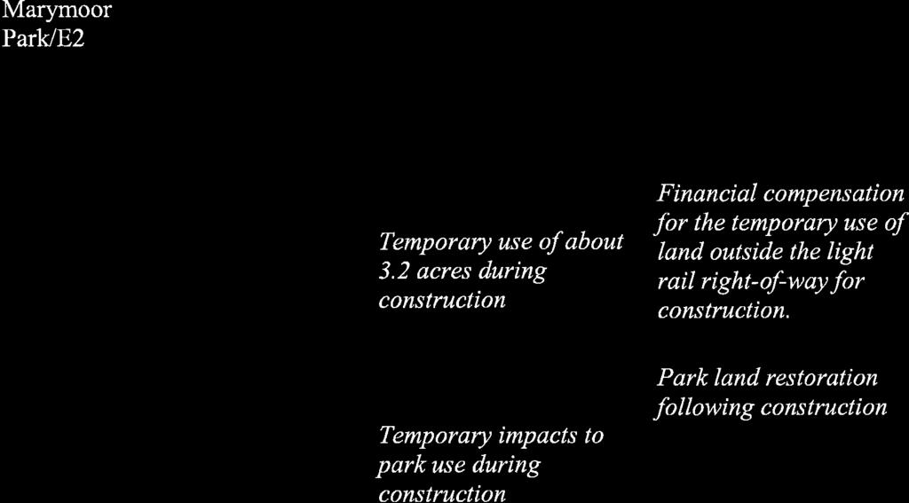
76
77
78
79
80
81
82
83
84
85 Attachment D2 Section 6(f) Photographs
86
87 118TH AVE SE BNSF Railway ELLEVUE WAY SE SE 8TH ST \\JAFAR\PROJ\SOUNDTRANSIT_341526\MAPFILES\SPECIALREQUESTS\MISC\SECTION6F_TRAILS.MXD RGRABARE 6/8/10 11:07:59 LAKE HILLS CONNECTOR 104TH AVE SE B E L L E V U E TH AVE SE Mer cer Sl ough E ast MERCER SLOUGH NATURE PARK 123RD AVE SE TH AVE SE 8 7 SE 25TH ST MERCER SLOUGH BELLEVUE WAY SE NATURE PARK B E A U X A R T S BNSF Railway 106TH AVE SE 112TH AVE SE SE 34TH ST MERCER SLOUGH NATURE PARK Source: Data from City of Bellevue (2005) and King County (2006). 2 Photo Location and Direction Recreational Water Trail Other Trail Section 6(f) Boundary Park Mile Attachment 2. Section 6(f) Area Photo Locations East Link Project


88 East Link Project Final EIS Photo 1 Photo 2


89 Photo 3. At ground level at water trail. Photo 4. Sitting on dock to simulate view from canoe trail. East Link Project Final EIS


90 Photo 5. Sitting on dock to simulate view from canoe trail. Photo 6. Sitting on dock to simulate view from canoe trail. East Link Project Final EIS


91 East Link Project Final EIS Photo 7 Photo 8


92 Photo 9 Photo 10. Standing on bench. East Link Project Final EIS


93 Photo 11. Sitting at water level. Photo 12. Canoe trail near intersection of Bellevue Way SE and 112th Avenue SE. East Link Project Final EIS
112th Avenue Light Rail Options Concept Design Report JUNE 2010 PREPARED FOR PREPARED BY TBG PGH
 112th Avenue Light Rail Options Concept Design Report JUNE 2010 PREPARED FOR PREPARED BY TBG060310124909PGH C ontents Introduction 1 Project Overview 1 Public Involvement and Technical Coordination 4 Description
Appendix E Section 4(f) Evaluation
 Evaluation") Appendix E Section 4(f) Evaluation Appendix E Draft Section 4(f) Evaluation E.1 Introduction This appendix addresses a federal regulation known as Section 4(f), which protects parks, recreation areas,
Appendix E Section 4(f) Evaluation Appendix E Draft Section 4(f) Evaluation E.1 Introduction This appendix addresses a federal regulation known as Section 4(f), which protects parks, recreation areas,
Description of Preferred Alternative
 Chapter 2 Description of Preferred Alternative 2.1 Introduction This chapter of the programmatic Sammamish Town Center Sub-area Plan Final EIS provides a more detailed description of the Preferred Alternative
Right-of-Way Acquisitions and Relocations Technical Memorandum
 Right-of-Way Acquisitions and Relocations Technical Memorandum Southeast Extension Project Lincoln Station to RidgeGate Parkway Prepared for: Federal Transit Administration Prepared by: Denver Regional
Gold Line Bus Rapid Transit Transit Oriented Development (BRTOD) Helmo Station Area Plan
 Helmo Station Area Plan") Appendix F Gold Line Bus Rapid Transit Transit Oriented Development (BRTOD) Helmo Station Area Plan Introduction and Purpose of the Plan The Gold Line Bus Rapid Transit facility is an eleven-mile dedicated
Appendix F Gold Line Bus Rapid Transit Transit Oriented Development (BRTOD) Helmo Station Area Plan Introduction and Purpose of the Plan The Gold Line Bus Rapid Transit facility is an eleven-mile dedicated
Abstract. See the Fact Sheet for persons who may be contacted for additional information concerning this document
 See the Fact Sheet for persons who may be contacted for additional information concerning this document Abstract The Central Puget Sound Regional Transit Authority (Sound Transit) proposes to construct
22a. Existing Condition. 22b. Simulation of NE 20th Street Alternative (D3)
") Appendix F4.5 Visual Consistency and Key Observation Point Analyses EXHIBIT F4.5-22 Key Observation Point 22 (looking east along NE 20th Street) 22a. Existing Condition 22b. Simulation of NE 20th Street
Appendix F4.5 Visual Consistency and Key Observation Point Analyses EXHIBIT F4.5-22 Key Observation Point 22 (looking east along NE 20th Street) 22a. Existing Condition 22b. Simulation of NE 20th Street
Transportation. Strategies for Action
 Transportation A major priority for the Overlake Neighborhood is to develop a multimodal transportation system. To achieve this system, a balance has to be found among travel, circulation and access needs;
RESOLUTION NO. R Refining the route, profile and stations for the Downtown Redmond Link Extension
 RESOLUTION NO. R2018-32 Refining the route, profile and stations for the Downtown Redmond Link Extension MEETING: DATE: TYPE OF ACTION: STAFF CONTACT: Capital Committee Board PROPOSED ACTION 09/13/2018
4.0 AFFECTED ENVIRONMENT AND ENVIRONMENTAL CONSEQUENCES
 4.0 AFFECTED ENVIRONMENT AND ENVIRONMENTAL CONSEQUENCES The following sections discuss the impacts associated with environmental resources for the tunneling method Alternatives A and B. The construction
APPENDIX D: Visual and Aesthetic Conditions for NCCU Station Refinement. Durham-Orange Light Rail Transit Project
 APPENDIX D: Visual and Aesthetic Conditions for NCCU Station Refinement Durham-Orange Light Rail Transit Project October 2016 1. Introduction The Combined FEIS/ROD summarizes the effects of the D-O LRT
Issues Requiring Future Study
 Issues Requiring Future Study Transportation planning is an ongoing process that tends to identify new issues as it finds solutions for others. Some issues are so complex that a solution to one problem
7.0 SECTION 4(F) EVALUATION
 EVALUATION") Chapter 7 Section 4(f) Evaluation 7.0 SECTION 4(F) EVALUATION 7.1 Background Information and Regulatory Requirements This chapter presents the existing conditions and potential effects to parklands and
Chapter 7 Section 4(f) Evaluation 7.0 SECTION 4(F) EVALUATION 7.1 Background Information and Regulatory Requirements This chapter presents the existing conditions and potential effects to parklands and
City of Tacoma Planning and Development Services
 Agenda Item D-3 City of Tacoma Planning and Development Services To: Planning Commission From: Stephen Atkinson, Associate Planner, Planning Services Division Subject: Land Use Designations - Phase 2 Meeting
The Illinois Department of Transportation and Lake County Division of Transportation. Route 173, including the Millburn Bypass
 The Illinois Department of Transportation and Lake County Division of Transportation welcome you to this Public Hearing for U.S. Route 45 from Illinois Route 132 to Illinois Route 173, including the Millburn
G. RECREATION AND OPEN SPACE ELEMENT. The following summarizes the Recreation and Open Space Element:
 G. RECREATION AND OPEN SPACE ELEMENT The purpose of the Element is to provide the framework and direction for a comprehensive system of public and private sites for recreation, including, but not limited
WELCOME! 8 8:30 6: TH STREET IMPROVEMENTS. Open House. Presentation & Q&A
 WELCOME! 168 TH STREET IMPROVEMENTS 6:30 Open House 7 8 Presentation & Q&A 8 8:30 Open House WELCOME Todd Pfitzer City of Omaha Engineer Bob Stubbe City of Omaha Public Works Director Jon Meyer Project
East Panorama Ridge Concept Plan Amendment
 Page 1 of 7 L003 : East Panorama Ridge Concept Plan Amendment Corporate NO: L003 Report COUNCIL DATE: March 4, 2002 REGULAR COUNCIL LAND USE TO: Mayor & Council DATE: February 27, 2002 FROM: General Manager,
3. VISION AND GOALS. Vision Statement. Goals, Objectives and Policies
 Vision Statement Queen Creek s interconnected network of parks, trails, open spaces and recreation opportunities provide safe and diverse activities and programs that sustain its unique, small town, equestrian
7.0 DRAFT SECTION 4(f) EVALUATION
 EVALUATION") 7. DRAFT SECTION 4(f) EVALUATION 7.1 Background Information and Regulatory Requirements This chapter presents the existing conditions and potential effects on parks, recreation areas, wildlife and waterfowl
7. DRAFT SECTION 4(f) EVALUATION 7.1 Background Information and Regulatory Requirements This chapter presents the existing conditions and potential effects on parks, recreation areas, wildlife and waterfowl
ELMVALE ACRES SHOPPING CENTRE MASTER PLAN
 ELMVALE ACRES SHOPPING CENTRE MASTER PLAN Contents 1.0 INTRODUCTION... 2 2.0 LOCATION... 2 3.0 EXISTING CONTEXT... 2 4.0 VISION & GUIDING PRINCIPLES... 2 5.0 LAND USE AND BUILT FORM... 4 5.1 St. Laurent
4.1 LAND USE AND HOUSING
 4.1 This section provides a project-level analysis of potential impacts to land use, Shorelines of the State (shorelines), and housing. The study area for the land use and housing analysis in the Final
Mitchell Ranch South MPUD Application for Master Planned Unit Development Approval Project Narrative. Introduction
 Mitchell Ranch South MPUD Application for Master Planned Unit Development Approval Project Narrative Introduction Mitchell Ranch South is a proposed single family (detached) residential development on
Visual and Aesthetic Resources
 Visual and Aesthetic Resources 7.1 INTRODUCTION This chapter evaluates the effects of the Modified Design on visual and aesthetic resources, in comparison to the effects of 2004 FEIS Design. The 2004 FEIS
DRAFT SECTION 4(f) EVALUATION INTERSTATE 73 FEIS: I-95 to I-73/I-74 in North Carolina
 EVALUATION INTERSTATE 73 FEIS: I-95 to I-73/I-74 in North Carolina") DRAFT SECTION 4(f) EVALUATION INTERSTATE 73 FEIS: I-95 to I-73/I-74 in North Carolina 1.0 INTRODUCTION Section 4(f) of the Department of Transportation Act of 1966, 49 U.S.C. 303, requires that prior to
DRAFT SECTION 4(f) EVALUATION INTERSTATE 73 FEIS: I-95 to I-73/I-74 in North Carolina 1.0 INTRODUCTION Section 4(f) of the Department of Transportation Act of 1966, 49 U.S.C. 303, requires that prior to
COMMUNITY DESIGN. GOAL: Create livable and attractive communities. Intent
 COMMUNITY DESIGN Intent An attractive, well-designed County will attract quality development, instill civic pride, improve the visual character of the community, and create a strong, positive image for
Planned Residential Neighborhoods Land Use Goals
 Planned Residential Neighborhoods Land Use Goals Issue: Guidelines that provide for diverse high quality residential areas that include a variety of housing styles and layouts are needed. Goal 1: Create
Goal 1: To Encourage the Orderly, Harmonious and Judicious Use of University Resources in the Development of University Land.
 2.0 Future Land Use Goal 1: To Encourage the Orderly, Harmonious and Judicious Use of University Resources in the Development of University Land. Objective 1.1: Make available future building sites that
The transportation system in a community is an
 7 TRANSPORTATION The transportation system in a community is an important factor contributing to the quality of life of the residents. Without a sound transportation system to bring both goods and patrons
East Corridor Final Environmental Impact Statement
 East Corridor Final Environmental Impact Statement Alternatives Considered Operating Plan The requirements for opening day operations versus year 2030 are based on ridership and operations. Opening day
1. Parks & Recreation Neighborhood Parks Community Parks Special Use Sites 2. Open Space 3. Trails
 Appendix A: Park Classifications The intent of parks and recreation classifications is to aid in making acquisition and design decisions for park sites, facilities and the organization of recreation space
Asbury Chapel Subdivision Sketch Plan
 Asbury Chapel Subdivision Sketch Plan PART 1: PROJECT SUMMARY Applicant: NVR Inc. Project Size: +/- 76.13 acres Parcel Numbers: 02101112,02116101,02116112, 02116113 Current Zoning: Transitional Residential
DOWNTOWN REDMOND LINK EXTENSION SEPA Addendum to the East Link Project Final Environmental Impact Statement
 DOWNTOWN REDMOND LINK EXTENSION 2018 SEPA Addendum to the East Link Project Final Environmental Impact Statement AUGUST 2018 Downtown Redmond Link Extension SEPA Addendum to the 2011 East Link Project
The West Vaughan Employment Area Secondary Plan Policies
 Part 2: The West Vaughan Employment Area Secondary Plan Policies 2.1 General Policies It is the policy of Council: 2.1.1. That the West Vaughan Employment Area (the WVEA), identified on Schedule 1, will
5.2 LAND USE AND ZONING
 5.2 LAND USE AND ZONING This section describes the land use and zoning of the project site and surrounding area, followed by an analysis of the potential for incompatibility or adverse impact on prevailing
7.5 Impacts on the Section 4(f) Properties
 Properties") constructive use, such as noise, air quality and visual impacts were also assessed. It was determined that this project would not introduce changes of an external nature that would affect the recreational
constructive use, such as noise, air quality and visual impacts were also assessed. It was determined that this project would not introduce changes of an external nature that would affect the recreational
ROAD CLOSURE AND LAND USE AMENDMENT SILVER SPRINGS (WARD 1) NORTHEAST OF NOSEHILL DRIVE NW AND SILVER SPRINGS ROAD NW BYLAWS 2C2018 AND 29D2018
 NORTHEAST OF NOSEHILL DRIVE NW AND SILVER SPRINGS ROAD NW BYLAWS 2C2018 AND 29D2018") Page 1 of 19 EXECUTIVE SUMMARY This application proposes redesignating two parcels in the community of Silver Springs from Special Purpose Future Urban Development (S-FUD) District and undesignated road
Page 1 of 19 EXECUTIVE SUMMARY This application proposes redesignating two parcels in the community of Silver Springs from Special Purpose Future Urban Development (S-FUD) District and undesignated road
4.1 AESTHETICS AND VISUAL QUALITY
 SCOPE AND METHODOLOGY 4.1 AESTHETICS AND VISUAL QUALITY This section evaluates the potential impacts to aesthetics and visual quality. Aesthetics refers to visual resources and the quality of what can
PROJECT BACKGROUND. Preliminary Design Scope and Tasks
 PROJECT BACKGROUND Preliminary Design Scope and Tasks The purpose of this Study is the development of preliminary designs for intersection improvements for Trunk Highway (TH) 36 at the intersections of
APPENDIX C Township 9 Consistency with Applicable Plans
 Township 9 Consistency with Applicable Plans 1985 American River Parkway Plan Policies Project Consistency Policy 4.14: The following activities and facilities, which are incompatible with the Parkway,
WELCOME TO OPEN HOUSE TWO November 28, 2018
 Langstaff Road Weston Road to Highway 7 Class Environmental Assessment Study WELCOME TO OPEN HOUSE TWO November 28, 2018 Please sign in and join our mailing list Study Overview York Region is conducting
DRAFT MAP AMENDMENT FLU 04-4
 DRAFT MAP AMENDMENT FLU 04-4 SW 24 TH AVENUE ROADWAY CORRIDOR The University of Florida participates with the Metropolitan Transportation Planning Organization (MTPO) in its responsibilities for the continuing,
AMENDMENT NO. 30 TO THE OFFICIAL PLAN OF THE TOWN OF MILTON
 AMENDMENT NO. 30 TO THE OFFICIAL PLAN OF THE TOWN OF MILTON Subject: Boyne Survey Secondary Plan and Related Official Plan Amendments The following text and schedules constitute Amendment No. 30 to the
A. INTRODUCTION B. PROJECT LOCATION
 Chapter 1: Project Description A. INTRODUCTION The Lower Manhattan Development Corporation (LMDC), a subsidiary of the New York State Urban Development Corporation, doing business as the Empire State Development
A. INTRODUCTION B. NO ACTION ALTERNATIVE
 Chapter 19: Alternatives A. INTRODUCTION Over the years a variety of potential developments for the East River waterfront in Lower Manhattan have been considered. Some of these plans were very ambitious
PART 1: PROJECT SUMMARY. Proposed Land Use: 120 single-family lots. The application is Attachment A. The site plan is Attachment B.
 PART 1: PROJECT SUMMARY Applicant: JBH Development, LLC and Hopper Communities, INC Project Size: +/- 80.48 acres Parcel Number: 01513107, 01513108, 01513109, 01513113, 01513120, 01513121, 01513122, 01513124,
Former Rockcliffe Airbase Community Design Plan Guiding Design Vision and Principles December 4, 2013
 APPENDIX 5 - Guiding Design Vision and Principles Former Rockcliffe Airbase Community Design Plan Guiding Design Vision and Principles December 4, 2013 Vision Statement The redevelopment of the former
PROJECT STATEMENT LOCATION/DESIGN PUBLIC HEARING. 19 th AVENUE NORTH EXTENSION PROJECT FROM SPRINGDALE DRIVE TO NORTH 2 ND STREET/U.S.
 PROJECT STATEMENT LOCATION/DESIGN PUBLIC HEARING 19 th AVENUE NORTH EXTENSION PROJECT FROM SPRINGDALE DRIVE TO NORTH 2 ND STREET/U.S. 67 HEARING LOCATION: ERICKSEN COMMUNITY CENTER 1401 11 TH AVENUE NORTH
SECTION 4(f) DE MINIMIS DOCUMENTATION
 DE MINIMIS DOCUMENTATION") SECTION 4(f) DE MINIMIS DOCUMENTATION Illinois Route 60/83 IL 176 to the intersection of IL 60 (Townline Road) Lake County P-91-084-07 Mundelein Park and Recreation District Project Limit SECTION 4(f)
SECTION 4(f) DE MINIMIS DOCUMENTATION Illinois Route 60/83 IL 176 to the intersection of IL 60 (Townline Road) Lake County P-91-084-07 Mundelein Park and Recreation District Project Limit SECTION 4(f)
Visual and Aesthetics
 Such a connection could accommodate timed transfers and improve connections between local transit service and Presidio Shuttle service. Level of Service The results of the analysis are provided on a route-by-route
4 LAND USE DESIGNATIONS
 4 LAND USE DESIGNATIONS Chapter 4 describes the land use designations and densities that will implement the development vision for North Burlingame outlined in Chapter 3. Land use densities are described
Chapter 22. Alternatives to the Proposed Project
 Page 22-1 Chapter 22. Alternatives to the Proposed Project Introduction This chapter assesses the potential environmental effects of alternatives to the Proposed Project. The alternatives analyzed include
Hockessin Community Redevelopment Plan
 Hockessin Community Redevelopment Plan 3.1 Introduction The Community Redevelopment Plan for the Village of Hockessin is the result of the people s vision for a distinct village center that serves as the
ARTICLE IV: DEVELOPMENT STANDARDS 404 MASTER PLANNING
 IV 13 404 MASTER PLANNING Master Planning through the Site Analysis (Master Planning Site Analysis) or Planned Development (Master Planning Planned Development) is provided to encourage development which
Access Management: An Overview
 Figures 1-5 Below Evolution of development along a highway. In the early stages, land along the road is used for farming with little traffic generated. As time passes, the highway corridor becomes a de
Gloucester County s Comprehensive Plan. The Community Connection
 Gloucester County s Comprehensive Plan The Community Connection Current Comp Plan Adopted in 1991 with a 20 year planning horizon Updated in 1995 with Part V- Implementation Recommendations and Appendix
Town of Portola Valley General Plan. Nathhorst Triangle Area Plan
 Town of Portola Valley General Plan Amended December 10, 1997 Table of Contents Introduction... 1 Planning Area... 1 Objectives... 2 Principles... 2 Standards... 4 Description... 4 Community Commercial...
3.5 VISUAL AND AESTHETIC QUALITIES
 3.5 VISUAL AND AESTHETIC QUALITIES 3.5.1 Introduction to Analysis 3.5.1.1 Summary of Results The Preferred Alternative would represent a minimal change to the visual character of the existing rail corridor.
Kankakee River Bridge & Track Improvements Supplemental Environmental Assessment. May 5, 2016
 Kankakee River Bridge & Track Improvements Supplemental Environmental Assessment May 5, 2016 1 History: Chicago-St. Louis Corridor Since 1980 s IDOT has been looking at this corridor for high-speed service
THE GARDEN CITY PLAN. City of St. Catharines Official Plan. City of St. Catharines
 THE GARDEN CITY PLAN City of St. Catharines Official Plan City of St. Catharines August 2010 APPROVAL INFORMATION This Official Plan of the City of St. Catharines Planning Area, known as the Garden City
Meeting Display Boards for Public Hearing on the Wilson Transfer Station Project held Tuesday, February 18, 2014.
 Meeting Display Boards for Public Hearing on the Wilson Transfer Station Project held Tuesday, February 18, 2014. Board 1: Welcome Welcome to the Wilson Transfer Station Project Public Hearing. The purpose
RECREATION AND OPEN SPACE ELEMENT
 RECREATION AND OPEN SPACE ELEMENT Last amended August 19, 2008 Table of Contents Objective Page 5.1 Park system defined... 5-1 5.2 Access to parks and recreational facilities... 5-2 5.3 Recreation and
DRAFT. 10% Common Open Space
 % OF CHARLOTTE IS CATEGORIZED AS A. LAND USES : Placeholder map displaying location of Place Type GOALS: Accommodate XX% of future growth. Provide a concentration of primarily commercial and civic activity
Parks, Trails, and Open space Element
 Parks, Trails, and Open space Element Parks, Trails, and Open Space element Parks, Recreation, and Open Space are important components of the quality of life desired by the residents of Elk Grove. This
5.4.6 Cumulative Operational Impacts
 5.4.5.2 Visual Character Impacts The proposed project is located in greater downtown Los Angeles, which is a dynamic environment where new projects are constructed on an ongoing basis. Additional development
Town Center (part of the Comprehensive Plan)
") Town Center (part of the Comprehensive Plan) Mercer Island Town Center Looking North (2014) In 1994, a year-long process culminated in a set of design guidelines and code requirements for the Town Center
Town Center (part of the Comprehensive Plan) Mercer Island Town Center Looking North (2014) In 1994, a year-long process culminated in a set of design guidelines and code requirements for the Town Center
AMEND DMENT H HOSPITAL
 AMEND DMENT TO LAND USE PLAN ELEMENT VILLAGE OF RIDGEWOOD MASTER PLAN H HOSPITAL ZONE DISTRICT Village of Ridgewood Planning Board February 28, 2014with technical revisions from June 9, 2014 Planning Board
Bus Rapid Transit Environmental Assessment and Section 4(f) Evaluation Summary
 Evaluation Summary") Bus Rapid Transit Environmental Assessment and Section 4(f) Evaluation Summary S.0 SUMMARY August 25, 2000 As a grantee of the Federal Transit Administration (FTA), the Greater Cleveland Regional Transit
Bus Rapid Transit Environmental Assessment and Section 4(f) Evaluation Summary S.0 SUMMARY August 25, 2000 As a grantee of the Federal Transit Administration (FTA), the Greater Cleveland Regional Transit
CITY OF PUYALLUP. Background. Development Services
 CITY OF PUYALLUP Development Services 333 South Meridian Puyallup WA 98371 To: City Council From: Katie Baker, AICP, Planning Division Re: South Hill Neighborhood Plan Adoption Date: (Meeting date: February
9 th Street Sub Area Plan
 9 th Street Sub Area Plan In the 1990 s, when the Township prepared the last Master Plan, the 9 th Street corridor was studied as part of a larger 9 th Street Focus Area that included the West Main Street
Transportation Improvements
 Transportation Improvements 0 0 Volume II of the Final EIS for the DHS Headquarters consolidation at St. Elizabeths includes analysis to transportation improvements for the DHS Headquarters Consolidation
Northwest Rail Corridor and US 36 BRT Development Oriented Transit Analysis 4.4 STATION AREA FINDINGS
 4.4 STATION AREA FINDINGS Each station is different, and each one requires a separate set of recommendations based on the vision for the site. This section outlines an initial TOD strategy and recommendations
DRAFT Amsterdam/Churchill Community Plan (4/17/08) Adopted By the Gallatin County Commission
 Adopted By the Gallatin County Commission") DRAFT Amsterdam/Churchill Community Plan (4/17/08) Adopted By the Gallatin County Commission Table of Contents Acknowledgements Chapter 1: Introduction A Brief History What s Next Authority Organization
DRAFT Amsterdam/Churchill Community Plan (4/17/08) Adopted By the Gallatin County Commission Table of Contents Acknowledgements Chapter 1: Introduction A Brief History What s Next Authority Organization
Appendix C: Interim Mixed-Use Evaluation Criteria
 Appendix C: Interim Mixed-Use Evaluation Criteria C-1 Appendix C: Interim Mixed-Use Evaluation Criteria PURPOSE: The implementation of numerous policies contained within the Master Plan hinges on the creation
BROOKHILL NEIGHBORHOOD MODEL ZONING MAP AMENDMENT PREFACE TO APPLICATION
 BROOKHILL NEIGHBORHOOD MODEL ZONING MAP AMENDMENT PREFACE TO APPLICATION June 15, 2015 Revised: August 1, 2016 I. VISION Brookhill is a proposed community based upon the principles of Albemarle County
PUBLIC HEARING. DRAFT Environmental Impact Statement. Matthews Memorial Baptist Church Washington, DC October 18, National Capital Region
 National Capital Region DRAFT Environmental Impact Statement PUBLIC HEARING Matthews Memorial Baptist Church Washington, DC October 18, 2007 Introduction Welcome and team introduction Hearing procedures
4.16 Historic and Archaeological Resources
 4.16 Historic and Archaeological Resources 4.16.1 Introduction to Resources and Regulatory Requirements The National Historic Preservation Act of 1966 (NHPA) Section 106 states that any federal or federally
2.4 FUTURE LAND USE ELEMENT Goals, Objectives and Policies
 GOAL 1: To create developmental patterns that direct future growth to appropriate areas on campus, in a manner that promotes the educational mission of the University, the protection of environmentally
6 PORT SYDNEY SETTLEMENT AREA
 Section 6 Port Sydney Page 61 6 PORT SYDNEY SETTLEMENT AREA 6.1 Basis and Principles Village of Port Sydney Waterfront Community Existing Services 6.1.1 Port Sydney is an historic settlement that has developed
Chapter IV: Development Pattern
 Chapter IV: Development Pattern Introduction The 2002 Prince George s County Approved General Plan designates three growth policy tiers Developed, Developing, and Rural as well as three center designations
DRAFT Northeast Quadrant of Kipling Avenue and Highway 7 DRAFT AUGUST 29, Goals Land Use. The goals of this Plan are to:
 AUGUST 29, 2017 12.15 Northeast Quadrant of Kipling Avenue and Highway 7 12.15.1 Goals 12.15.2 Land Use The goals of this Plan are to: 12.15.2.1 General Provisions: a) Ensure the development of a compact
Commissioners Road West Realignment Environmental Assessment
 City of London Commissioners Road West Realignment Environmental Assessment Public Information Centre No. 1 March 30, 2017 Welcome to the Public Information Centre This first Public Information Centre
CHAPTER 7: VISION AND ACTION STATEMENTS. Noble 2025 Vision Statement
 CHAPTER 7: VISION AND ACTION STATEMENTS This chapter presents the vision, policy and action statements that transform the comprehensive planning study, an analysis of Noble s past, future trends and community
Open Space and Recreational Facilities
 Chapter 5: Open Space and Recreational Facilities A. INTRODUCTION According to the guidelines of the 2001 New York City Environmental Quality Review (CEQR) Technical Manual, an open space analysis is necessary
B. PROPOSED REFINEMENTS POTENTIALLY AFFECTING URBAN DESIGN AND VISUAL RESOURCES
 Chapter 4: Urban Design and Visual Resources A. CONCLUSIONS OF THE FGEIS The FGEIS concluded that the Approved Plan will not result in any significant adverse impact on urban design or visual resources.
Public input has been an important part of the plan development process.
 Lakewood s Comprehensive Plan recognizes that transportation helps shape the community, and that the way the community provides for the safe and efficient movement of people affects the character of the
LAND USE ELEMENT. Purpose. General Goals & Policies
 LAND USE ELEMENT Purpose This Land Use Element contains the goals and policies necessary to support the City s responsibility for managing land resources and guiding development through implementing regulations,
Shift Rapid Transit Public Participation Meeting May 3, 2017
 Shift Rapid Transit Public Participation Meeting May 3, 2017 Shift Rapid Transit Initiative Largest infrastructure project in the city s history. Rapid Transit initiative will transform London s public
Mississippi Skyway Preliminary Engineering Report
 EXECUTIVE SUMMARY Mississippi Skyway Preliminary Engineering Report CITY OF RAMSEY, MINNESOTA DECEMBER 2014 City of RAMSEY EXECUTIVE SUMMARY Project Need and Intent The Mississippi Skyway pedestrian bridge
hermitage town center
 hermitage town center A Community Vision prepared by Strada for The City of Hermitage and The Mercer County Regional Planning Commission January 2007 table of contents introduction 3 design principles
2.1.8 Cultural Resources Regulatory Setting. Affected Environment, Environmental
 REVISED DRAFT ENVIRONMENTAL IMPACT REPORT/ Affected Environment, Environmental 2.1.8 Cultural Resources This section evaluates the potential for historical and archaeological resources within the proposed
Rio/29 Small Area Plan. Design Plan & Implementation Framework Open House - January 25, 2018
 Rio/29 Small Area Plan Design Plan & Implementation Framework Open House - January 25, 2018 MEETING PURPOSE PRESENTATION 1. Orient to the updated design plans 2. Introduce implementing options 3. Explain
Chapter Master Planned Communities (MPC) District
 District") Sections 14.53.010 Purpose and Intent 14.53.020 Applicability 14.53.030 Procedure 14.53.040 MPC Standards 14.53.050 Required Findings 14.53.010 Purpose and Intent Chapter 14.53 Master Planned Communities
Sections 14.53.010 Purpose and Intent 14.53.020 Applicability 14.53.030 Procedure 14.53.040 MPC Standards 14.53.050 Required Findings 14.53.010 Purpose and Intent Chapter 14.53 Master Planned Communities
Century Highfield Sub Area Plan
 Century Highfield Sub Area Plan The Century Highfield Sub Area Plan provides an opportunity to re evaluate the vision that was set forth for this area when the Township conducted a similar planning exercise
Public Meeting #3 May 9, 2009 MVVA Team
 Public Meeting #3 May 9, 2009 MVVA Team Welcome to the third Public Meeting for the Lower Don Lands Municipal Class Environmental Assessment (EA) Infrastructure Master Plan and Keating Channel Precinct
Purpose of Open House #3
 Public Meeting #3 May 9, 2009 MVVA Team Purpose of Open House #3 The main purpose of this Open House is to present and seek input on the: Evaluation of transportation and infrastructure design alternatives
ARLINGTON COUNTY, VIRGINIA. County Board Agenda Item Meeting of January 28, 2017 SUPPLEMENTAL REPORT
 ARLINGTON COUNTY, VIRGINIA County Board Agenda Item Meeting of January 28, 2017 SUPPLEMENTAL REPORT DATE: January 26, 2017 SUBJECT: The Virginia Department of Transportation s Transform I-66 Inside the
Open Space and Recreational Resources
 Chapter 3: Open Space and Recreational Resources A. INTRODUCTION Under the 2012 City Environmental Quality Review (CEQR) Technical Manual guidelines, open space is defined as publicly accessible, publicly
Project Purpose. Project Need
 Project Purpose The purpose of the project is to implement a bridge improvement solution that corrects the existing safety problem at the Strasburg Pike Bridge. The project will provide a structurally
3.10 LAND USE SETTING PROJECT SITE EXISTING LAND USE DESIGNATIONS AND ZONING. General Plan Land Use Designations.
 This section of the Draft EIR addresses the existing land uses on and adjacent to the project site and discusses the potential impacts of the proposed project on existing land uses. Key issues addressed