Central City Sector Plan Update. Agenda: What is a sector plan Timeline Definition of terms Survey results Participant questions
|
|
|
- Harry Stevens
- 5 years ago
- Views:
Transcription


1 Central City Sector Plan Update Agenda: What is a sector plan Timeline Definition of terms Survey results Participant questions


2 What is a Sector Plan? Furthers the General Plan goals 12 sectors within the General Plan 15-year time horizon Guides capital improvements program Covers land use, community facilities, and transportation Growth Policy Plan Sector Plans Corridor Plans Small Area Plans System Wide Plans
3 Neighborhood, Small Area and Corridor Plans since 2003 Oakwood Lincoln Park Neighborhood Plan Lonsdale Neighborhood Plan Magnolia Avenue Corridor Plan I-275/North Central Street Corridor Study MLK, Jr. Avenue Corridor Plan Broadway, Central, Emory Place Small Area Plan Cumberland Avenue Corridor Plan
4 Timeline


5 Definition of Terms Mixed-use development: Mixed-use development is the practice of allowing more than one type of use in a building or set of buildings. Adjacent, single uses Small scale vertical mixed-use Large scale vertical mixed-use


6 Definition of Terms Infill development: New development that is sited on vacant or undeveloped land within an existing community, and that is enclosed by other types of development. Assisted living facility on Broadway Infill Housing Overlay
7 Definition of Terms Brownfield redevelopment: The expansion, redevelopment, or reuse of property which may be complicated by the presence or potential presence of a hazardous substance, pollutant, or contaminant. I-275 Corridor former rail yards and industrial sites


8 Definition of Terms Greyfield redevelopment: Economically obsolescent, outdated, failing, and/or underused real estate assets or land. Typically associated with commercial strip centers and malls. Before After


9 Definition of Terms Complete streets: Complete streets: Roadways designed and operated to enable safe access for all users. Pedestrians, bicyclists, motorists and bus riders of all ages and abilities are able to safely move along and across a complete street


10 Protection of established neighborhoods General Recommendations from Recent Plans in Central City Historic Overlay Neighborhood Conservation Overlay Infill Housing Overlay Redevelop Corridors Redevelop Corridors Redevelopment districts - KCDC Public Realm Complete streets (Cumberland Avenue) Private Realm Allow mixed-use development where appropriate Redevelop Brownfields Redevelopment districts KCDC I-275 Industrial Park - manufacturing/warehousing\ New Walmart / Publix west of UT campus Reinforce downtown as the capital of the region Downtown Design Overlay Adaptive reuse of older buildings Residential and retail growth
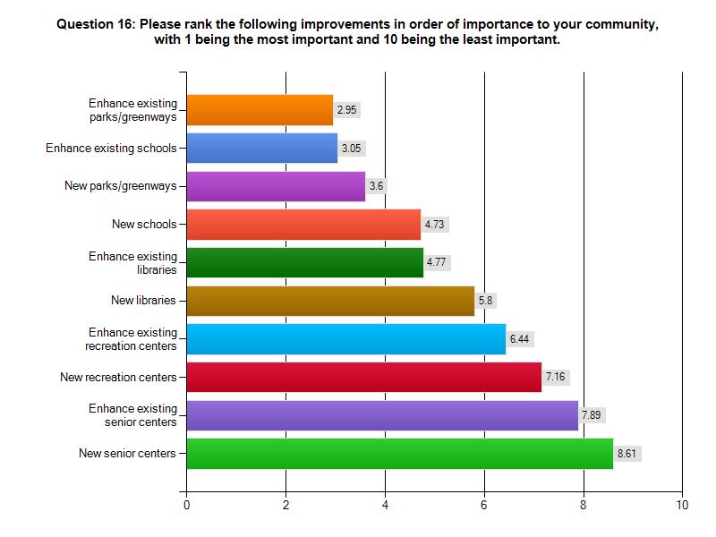
11 Survey: Neighborhood Questions

12 90% Open Responses: Historic Edgewood had 60 responses. It is within the boundary of Parkridge which brings that total to 40.5% of the total responses.

13 86%

14 Open Responses: Social service organizations congregating in and around neighborhoods; hoods; Quality schools; Codes enforcement; More owner occupancy; Future use of Standard Knitting Mill
15 Summary: Neighborhood Questions Increase quality of life by creating a safe and enjoyable environment to live/work/shop. Address crime and safety concerns with available planning tools. For example, utilize the Crime Prevention Through Environmental Design program to determine issues and ways to address them. Work with the City of Knoxville and KCDC to address blight/rundown properties using Codes Enforcement and Redevelopment Districts. Allow new development and redevelopment that does not detract from the architectural heritage of the area. Use overlay zones with design guidelines, or new zoning districts with design criteria, to require development to fit its surroundings. COMMENTS?
16 Survey: Land Use Questions

17 Partially or entirely designated with a mixed-use land use. Open Responses: Compatible uses; Architectural style; Mixed-use buildings; Adaptive reuse of existing structures; Infill development
18 Potential Mixed-Use Districts

19 Smaller stores, such as Ace Hardware and Three Rivers Market, can easily be accommodated along urban corridors. Open Responses: Neighborhood commercial nodes; Farmer s Market; Daycare; Crafts store

20 Indicates that the issue/concern received more than a 50% response rate in Questions 7,8,9. Open Responses: Crime; Safety; Density; Codes enforcement; Owner occupancy

21 Open Responses: Compatible uses; Flexible parking standards

22 Open Responses: Owner occupied; Compliance with design guidelines
23 Open Responses: Diversity of jobs/housing; Social services; Brownfields

24 Open Responses: Reuse existing vacant facilities; In suburban or rural areas
25 Existing Industrial Areas
26 Summary: Land Use Questions Allow a mix of uses along the corridors with targeted areas for more concentrated development. Most corridors near downtown already have a mixed-use land use designation. New zoning districts will need to be created to allow for mixed-use development. Build upon existing neighborhood oriented commercial centers, such as Happy Holler, to provide for smaller services like restaurants and a clothing stores. Larger stores, such as hardware and grocery store, should be located along major roads and preferably near a transit stop. The architectural style and massing of new/renovated buildings should s be compatible with adjacent structures. Parking should be screened from other uses so as not to be a nuisance. Form-based codes and overlay districts can be used to shape new development to meet the expectations and vision of the surrounding community. Redevelopment of underutilized properties offers the best opportunity for new jobs and economic development. There are many redevelopment districts targeting blighted areas that can absorb new and expanding businesses. COMMENTS?
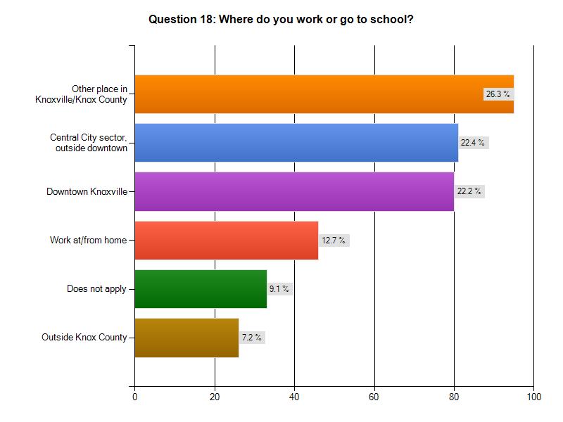
27 Survey: Community Facility Questions

28 Need the most attention. Open Responses: Quality schools; First Creek Greenway

29 68%


30 Open Responses: Bill Myers Stadium reuse; Soccer fields; Dog park; Shade; Restrooms oms
31
32 Summary: Community Facility Questions Increasing the quality of the schools are a high priority. Sector plan recommendations do not effect school board decisions, however, it does provide more context into the communities concerns. Recreational opportunities need to be enhanced and expanded, including greenways, parks, ball fields and recreation centers. The Knoxville Knox County Park, Recreation and Greenways Plan (2009) is a comprehensive guide for the proposed build out of the countywide park and greenway system. In the Central City Sector, the primary new facility recommendations are for greenways and greenway connectors. COMMENTS?
33 Survey: Transportation Questions
34 Open Responses: Pedestrian safety; Taxi; Trolley; Motorcycle/scooter
35 58%

36 53%
37 * Recently adopted plans with recommendations that will be brought forward Open Responses: Maintenance of roads/sidewalks; Signal timing

38 Conversion to Complete Streets

39 Open Responses: Washington; Jefferson; Winona; Fifth; Woodbine; Glenwood; Luttrell; Gill; Oklahoma; Oglewood; ; Woodland; Kenyon; Anderson; Arthur; Deaderick

40 Open Responses: Safety; Trolley; Information; Post routes/cost; Convenience; Reliability; Additional routes

41 Open Responses: Safety/crime; Parking on sidewalks; Bike lanes; Better sidewalks; ; Speeding

42 Open Responses: Better pedestrian connections; Safety/crime; Maintenance of sidewalks; Lighting

43 High number of no opinion responses. Open Responses: Landscaping; Crosswalks; Sidewalks; Traffic signals; Greenways; Bike lanes; Maintenance
44
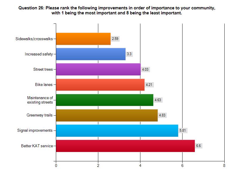
45 Summary: Transportation Questions Car travel is the predominant mode of transportation for daily trips. Walking and cycling are used periodically throughout the week. Safe routes and improved pedestrian connections to destinations, such as downtown, are needed. Sidewalk, crosswalk and bike lane improvements are needed on our major streets, along with streetscape enhancements. Complete street designs take these improvements into consideration. Speeding vehicles are a concern on neighborhood streets. The City Engineering Department will need to be involved in any recommendations for modifications to the roadway, such a traffic calming enhancements or additional stop signs. A more reliable, convenient and comfortable experience is desired to increase the use of KAT bus service, but it is not a high priority. COMMENTS?
46 Overall Survey Summary Development that contributes to the overall quality of life for all those that live/work/shop in the area. Convenient access to daily services, whether by car, walking or biking. Mixed-use development that is compatible in scale to the surrounding uses and appropriately located. Safe and convenient pedestrian connections to destinations such as parks, employment centers, retail and entertainment. COMMENTS?
47 Potential Tools

48 Crime Prevention/Safety CRIME PREVENTION THROUGH ENVIRONMENTAL DESIGN (CPTED) is an approach to problem-solving that asks, what is it about this location that places people at risk, or that results in opportunities for crime? In other words, why here? Large windows at upper levels promote casual supervision of street Clear building signage Exterior of building well illuminated Large windows at-grade promote casual supervision of street Clearly define private and public space Good pedestrian-scaled lighting on street CPTED attempts to reduce or eliminate crime and undesirably behavior by changing various aspects of the building, the site, the location, and how places are used by: (1) control access; (2) provide opportunities to see and be seen; and (3) define ownership and encourage the maintenance of territory (property).

49 Crime Prevention/Safety VARIOUS PLANNING AND DESIGN STRATEGIES THAT ENHANCE SECURITY: Allow for clear sight lines Provide adequate lighting Minimize concealed and isolated routes Avoid entrapment Reduce isolation Promote land use mix Use of activity generators Create a sense of ownership through maintenance and management Provide signs and information Improve overall design of the built environment Large windows promote casual supervision of sidewalks Porches and sidewalks encourage interaction between neighbors Paving and architectural treatments define public and private zones Good pedestrian-scaled lighting on street Low landscaping and fences define property lines without creating hiding places
50 Mixed-use Development Mixed-use development: Mixed-use development is the practice of allowing more than one type of use in a building or set of buildings. Adjacent, single uses Small scale vertical mixed-use Large scale vertical mixed-use


51 Corridors: New Development CONVENTIONAL RETAIL URBAN FORM MIXED USE
52 Protecting Architectural Character EXISTING ZONING AND GUIDELINES HISTORIC OVERLAY NEIGHBORHOOD CONSERVATION OVERLAY INFILL HOUSING OVERLAY DOWNTOWN KNOXVILLE DESIGN OVERLAY HISTORIC OVERLAY FAÇADE IMPROVEMENT PROGRAM DESIGN GUIDELINES INFILL HOUSING OVERLAY


 CORRIDOR")
53 Protecting Architectural Character POTENTIAL ZONING AND GUIDELINES CORRIDOR OVERLAY FORM BASED ZONING RHK-1 (HEART OF KNOXVILLE RESIDENTIAL ZONE) CORRIDOR OVERLAY FORM BASED ZONING
54 Blighted/Rundown Properties REDEVELOPMENT DISTRICTS Administered by KCDC Purpose: Elimination of areas with buildings or improvements that are detrimental to the safety, health, morals, or welfare of the community. Example PLAN OBJECTIVES FROM MAGNOLIA AVENUE WAREHOUSE DISTRICT REDEVELOPMENT PLAN ESTABLISH STANDARDS AND GUIDELINES FOR THE REDEVELOPMENT AND CONTINUED USE OF THE AREA which will assure adequate light, air, open-space, off-street parking, and the future stability of the entire area through adequate development. ELIMINATE CONDITIONS OF BLIGHT AND BLIGHTING INFLUENCES, INCOMPATIBLE AND INAPPROPRIATE LAND USES, and assist in beautifying the area. ENCOURAGE EFFECTIVE AND DESIRABLE USES OF LAND IN ACCORDANCE WITH THE MPC PLAN, including, but not limited to maintaining current industrial and warehouse uses. FACILITATE OPPORTUNITIES FOR MORE INTENSE, MIXED-USE DEVELOPMENT, including a vertical mix of retail, housing and office uses. ENCOURAGE CONSERVATION, RESTORATION AND REUSE OF HISTORIC RESOURCES FACILITATE IMPROVEMENTS TO THE SIDEWALK, BICYCLE AND STREET SYSTEMS, including standards for on-and off-street parking, fostering greater intensity in development and providing improved access to existing businesses. Such public improvements may also include improved lighting and improved access to existing public improvements. FACILITATE IMPROVEMENTS TO PARKS AND OPEN SPACES, including, but not limited to, new squares, day-to-day access to the First Creek Greenway and other pedestrian passageway.
55 Blighted/Rundown Properties
56 Blighted/Rundown Properties RUNDOWN PROPERTIES Administered by the City of Knoxville NEIGHBORHOOD CODES ENFORCEMENT Investigates codes violations regarding dilapidated buildings, dirty or overgrown lots, illegal dumping and abandoned vehicles. BETTER BUILDING BOARD The Public Officer issues complaints to property owners regarding structures that are alleged to be unfit or dangerous. The Better Building Board hears appeals of the Public Officer's orders. COMMUNITY DEVELOPMENT Identify vacant, blighted or problem properties and seek developers to return them to productive use. LAND USE AND ZONING Administered by MPC and City Council Classify properties appropriately to spur redevelopment of underutilized properties.
57 Participant Questions
58 Community Facilities Community Facilities: Park Plan

59 Community Facilities Community Facilities: Park Plan What could be done to improve parks and greenways near your home?
60 Complete Streets


61 Complete Streets Are the complete street transportation proposals, including more sidewalk and bicycle connections, things that you support?

62 Transit and Mixed-use Corridors
63 Transit and Mixed-use Corridors More transit service and less wait times, which is part of Bus Rapid Transit,, require more people and employment near certain corridors. Would you support more apartments and office development along Cumberland Avenue, Broadway and Magnolia Avenue?
64 Transit and Mixed-use Corridors Are there other transportation improvement that you would recommend?
65 Potential Mixed-use Districts


66 Potential Mixed-use Districts Are you comfortable with the land use designation for the blocks near your house?
67 Additional Comments or Questions For more information: Mike Reynolds
2014 CENTRAL CITY SECTOR PLAN LAND USE: PROPOSED MIXED USE DISTRICTS
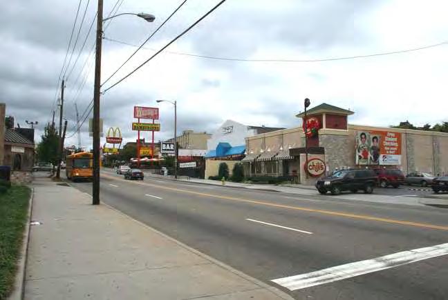
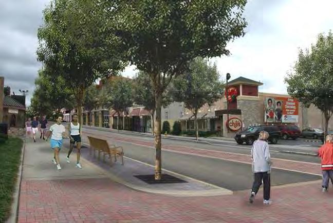
 MU-CC9: North Central Corridor (north of Woodland) Mixed use and single use development is allowed. New structures should be designed to support a pedestrian friendly environment, such as these buildings
CHAPTER 3 VISION, GOALS, & PLANNING PRINCIPLES. City of Greensburg Comprehensive Plan. Introduction. Vision Statement. Growth Management Goals.
 CHAPTER 3 VISION, GOALS, & PLANNING PRINCIPLES Introduction The Greensburg Comprehensive Plan is intended as a working community document. A combination of long and short-term goals, this document is intended
4.1.3 LAND USE CATEGORIES
 4.1.3 LAND USE CATEGORIES a. City Center District The City Center District incorporates the existing character and mix of uses in downtown Belmont to encourage redevelopment and new development in keeping
East Central Area Plan
 East Central Area Plan Steering Committee Meeting March 8 th, 2018 CHUN Tears McFarlane House Vision Statement Development Opportunities Analysis Vision Elements 1. Equitable, Affordable and Inclusive
SUMMERSIDE / MT. CARMEL REINVESTMENT CORRIDOR COMMUNITY DEVELOPMENT STRATEGY
 SUMMERSIDE / MT. CARMEL REINVESTMENT CORRIDOR COMMUNITY DEVELOPMENT STRATEGY FEBRUARY 2013 I. Location of the Summerside/Mt. Carmel Reinvestment Corridor The Summerside/Mt. Carmel Reinvestment Corridor
A larger version of this map is located on the last page of this PDF.
 MAP Committee Input McLoughlin Area Draft Vision Map A larger version of this map is located on the last page of this PDF. 1. The map above is intended to portray a vision for the McLoughlin area. It highlights
The transportation system in a community is an
 7 TRANSPORTATION The transportation system in a community is an important factor contributing to the quality of life of the residents. Without a sound transportation system to bring both goods and patrons
EXECUTIVE SUMMARY DRAFT CHAPTER 1 INTRODUCTION EXECUTIVE SUMMARY
 CHAPTER 1 EXECUTIVE SUMMARY INTRODUCTION Through the joint efforts of the City of Tulsa planning staff and the Land Services division of Indian Nations Council of Governments (INCOG), the Berryhill Land
The Five Components of the McLoughlin Area Plan
 The Five Components of the McLoughlin Area Plan This documents contains the complete language of the five components of the McLoughlin Area Plan: The Vision Statement The Values The Guiding Principles
A BLUEPRINT FOR BROCKTON A CITY-WIDE COMPREHENSIVE PLAN
 A BLUEPRINT FOR BROCKTON A CITY-WIDE COMPREHENSIVE PLAN Public Meeting October 2016 1 Plan Summary and Discussion Public Meeting May 4 2017 City of Brockton Bill Carpenter, Mayor Department of Planning
CHAPTER 7: Transportation, Mobility and Circulation
 AGLE AREA COMMUNITY Plan CHAPTER 7 CHAPTER 7: Transportation, Mobility and Circulation Transportation, Mobility and Circulation The purpose of the Transportation, Mobility and Circulation Chapter is to
Volume 2: Implementation Plan
 Volume 2: Implementation Plan February 25 th 2002 Implementation Introduction This document outlines the steps that should be taken to implement the Washington Heights Neighborhood Plan. The City Council
Sahuarita District & Phase 1 Master Plan. Town Council December 11, 2017
 Sahuarita District & Phase 1 Master Plan Town Council December 11, 2017 Visioning Study Visioning Process Advisory Group Meetings Community Questionnaire Town Center Case Studies Community Analysis The
Town Center (part of the Comprehensive Plan)
") Town Center (part of the Comprehensive Plan) Mercer Island Town Center Looking North (2014) In 1994, a year-long process culminated in a set of design guidelines and code requirements for the Town Center
Town Center (part of the Comprehensive Plan) Mercer Island Town Center Looking North (2014) In 1994, a year-long process culminated in a set of design guidelines and code requirements for the Town Center
THE NEIGHBORHOOD TODAY
 THE NEIGHBORHOOD TODAY CORE AREA VISION How are we Good Urbanism A Site s DNA thinking about Elements of great Unique elements urban communities embedded in a place the site and design? ELEMENTS LIKE:
Olde Towne Vision Plan
 Olde Towne Vision Plan Introduction In 2016, the City of Bellevue will complete its move of City offices from Olde Towne Bellevue to its new municipal complex on Wall Street. The City intends to sell its
CHAPTER 2: FUTURE LAND USE CONCEPTS
 CHAPTER 2: FUTURE LAND USE CONCEPTS INTRODUCTION The future land use concepts presented in this chapter are an expression of community support for a viable and vital US 50 Corridor. Land use recommendations
The University District envisions, in its neighborhood
 Envisioning the University District Link Light Rail in Seattle s neighborhoods CIY OF SEALE CONCEP-LEVEL SAION AREA PLANNING RECOMMENDAION RESOLUION # 30165 EXHIBI L Vision 08.2000 he University District
RESIDENTIAL DISTRICTS
 RESIDENTIAL DISTRICTS The residential district standards have been revised to reflect on-the-ground conditions, while continuing to respect the use patterns established within the neighborhoods. This will
[PLANNING RATIONALE] For Site Plan Control and Lifting of Holding Zone By-Law 101 Champagne Avenue. May 23, 2014
![[PLANNING RATIONALE] For Site Plan Control and Lifting of Holding Zone By-Law 101 Champagne Avenue. May 23, 2014](/thumbs/75/71599615.jpg "[PLANNING RATIONALE] For Site Plan Control and Lifting of Holding Zone By-Law 101 Champagne Avenue. May 23, 2014") [PLANNING RATIONALE] For Site Plan Control and Lifting of Holding Zone By-Law 101 Champagne Avenue May 23, 2014 Contents 1.0 Introduction... 2 2.0 Site Context... 2 2.1 Adjacent Uses... 2 Figure 1: Site
[PLANNING RATIONALE] For Site Plan Control and Lifting of Holding Zone By-Law 101 Champagne Avenue May 23, 2014 Contents 1.0 Introduction... 2 2.0 Site Context... 2 2.1 Adjacent Uses... 2 Figure 1: Site
C. Westerly Creek Village & The Montview Corridor
 C. Westerly Creek Village & The VISION Community Vision When the goals of the city are achieved Westerly Creek Village, a distinctive community defined by Montview Boulevard and Westerly Creek, is a strong
Urban Design Manual PLANNING AROUND RAPID TRANSIT STATIONS (PARTS) Introduction. Station Study Areas
 Introduction. Station Study Areas") 111111 PLANNING AROUND RAPID TRANSIT STATIONS (PARTS) Introduction The ION rapid transit system will link Waterloo, Kitchener and Cambridge through a central transit corridor (CTC). There are a number
111111 PLANNING AROUND RAPID TRANSIT STATIONS (PARTS) Introduction The ION rapid transit system will link Waterloo, Kitchener and Cambridge through a central transit corridor (CTC). There are a number
SECTION UNIFIED DEVELOPMENT ORDINANCE SECTION Part 1 Ordinance. ARTICLE 1 Zoning Districts
 SECTION 1-100 UNIFIED DEVELOPMENT ORDINANCE SECTION 1-300 Part 1 Ordinance SECTION 1-100. Introduction. ARTICLE 1 Zoning Districts Crystal Lake strives to maintain a balance of various land uses for a
SECTION II SECTION II STATEMENT OF GOALS, OBJECTIVES, PRINCIPLES, ASSUMPTIONS, POLICIES AND STANDARDS
 STATEMENT OF GOALS, OBJECTIVES, PRINCIPLES, ASSUMPTIONS, POLICIES AND STANDARDS 1 2 STATEMENT OF GOALS, OBJECTIVES, PRINCIPLES, ASSUMPTIONS, POLICIES AND STANDARDS INTRODUCTION The New Jersey Municipal
Midtown Greenway Land Use and Development Plan Executive Summary
 Midtown Greenway Land Use and Development Plan Executive Summary Introduction The Midtown Greenway Land Use and Development Plan sets policy direction for land use and development in the Midtown Greenway
Planned Development Review Revisions (Project No. PLNPCM )
") Planned Development Review Revisions (Project No. PLNPCM2014-00139) Standard residential development Planned Development Example: Smaller lot sizes than what is allowed to create open space amenity. What
Planned Development Review Revisions (Project No. PLNPCM2014-00139) Standard residential development Planned Development Example: Smaller lot sizes than what is allowed to create open space amenity. What
Plano Tomorrow Vision and Policies
 Plano Tomorrow Vision and Policies PLANO TOMORROW PILLARS The Built Environment The Social Environment The Natural Environment The Economic Environment Land Use and Urban Design Transportation Housing
Silverdale Regional Center
 Silverdale Regional Center Vision for Silverdale Regional Center The Silverdale Regional Center Plan (Plan) will guide the evolution of the Silverdale Regional Center from a collection of strip malls and
INDEPENDENCE BOULEVARD AREA PLAN
 INDEPENDENCE BOULEVARD AREA PLAN Public Meeting October 28, 2008 Tonight s Agenda Introduction 4:00 4:05 Tom Warshauer Presentation 4:05 5:00 Blake Drury Group Exercises 5:00 5:50 All Wrap Up & Next Steps
Equitable Growth Through TOD Planning
 Equitable Growth Through TOD Planning Community Meeting # 2 November 2017 Goals Objectives Extend investment from downtown Connect neighborhoods physically and economically Enhance places based on local
Public input has been an important part of the plan development process.
 Lakewood s Comprehensive Plan recognizes that transportation helps shape the community, and that the way the community provides for the safe and efficient movement of people affects the character of the
The Lincoln Neighborhood Corridor Plan. The LiNC
 October 1, 2014 Planning Commission Study Session The Lincoln Neighborhood Corridor Plan The LiNC Purpose of Tonight s Meeting Introduction to The LiNC Review of Existing Conditions and Community Identified
01 the vision NEW LYNN IS WAITING FOR THE GREAT LEAP FORWARD
 [A] FRAMEWORK 01 the vision 02 the framework 03 urban design principles 04 c o n t e x t 05 issues a n d o p p o r t u n i t i e s 06 creating a t.o.d. 07 key recommendations 08 seven strategic areas of
In surveys, Dallas residents say what they want to change most
 NEIGHBORHOODS ELEMENT In surveys, Dallas residents say what they want to change most in the city is its appearance they want it to look beautiful, with trees and pedestrian-friendly neighborhoods. The
Public Meeting Final Recommendations August 8, 2013
 Public Meeting Final Recommendations August 8, 2013 Meeting Agenda 1. Existing Conditions 2. Plan Building Blocks & Process 3. The Plan Policies 4. What we heard 5. Next Steps Existing Conditions Existing
6. DOWNTOWN. The Downtown Element focuses on supporting and expanding the vitality and enhancement of Downtown Chico as the City s central core.
 VISION In 2030, Downtown Chico is the heart of the community and the center of cultural activity. Engaging and active at the street level, it is a multi-story, mixed-use hub, with specialty retail, restaurants,
Urban Design. in the City of Kitchener. MUDR Presentation May 2010
 Urban Design in the City of Kitchener MUDR Presentation May 2010 Highlights Direction: long term commitment to urban design in Kitchener Themes: density, mixed use, community focal points, transit, accessibility
TOD 101 CREATING LIVABLE COMMUNITIES WITH TRANSIT
 1 CREATING LIVABLE COMMUNITIES WITH TRANSIT What are transit Centered Communities? Benefits of Partnerships to Support and Implement What You Will Learn Portland s Pearl District Your Trainers Today Catherine
Making TOD Work in the Heart of Suburban Sprawl
 Making TOD Work in the Heart of Suburban Sprawl Rocky Mountain Land Use Institute March 6, 2009 Speakers Ben Herman, FAICP, Principal Clarion Associates Darcie White, AICP, Principal Clarion Associates
WEST OAKLAND SPECIFIC PLAN & DRAFT ENVIRONMENTAL IMPACT REPORT
 WEST OAKLAND SPECIFIC PLAN & DRAFT ENVIRONMENTAL IMPACT REPORT Landmarks Preservation Advisory Board Public Hearing February 10, 2014 1 Specific Plan Overview Plan Area is generally bounded by I-580 to
Public Meeting May 20, 2014
 Public Meeting May 20, 2014 Overview Study Purpose Study Area Overview Strategies Potential Opportunities Implementation and Discussion Skeo Solutions Raleigh Walkable Watershed Pilot 2 Purpose Develop
DRAFT City of Titusville 2040 Comprehensive Plan Future Land Use, Housing, and Transportation Elements April 16, 2018
 DRAFT City of Titusville 2040 Comprehensive Plan Future Land Use, Housing, and Transportation Elements April 16, 2018 Prepared by Canin Associates for the City of Titusville About the Comprehensive Plan:
Planning Districts INTRODUCTION
 INTRODUCTION To facilitate detailed examination of development prospects for all areas of the community, Delano has been divided into 14 planning districts. The location of these planning districts is
Table of Contents. Elm Avenue Improvement Plan City of Waco, Texas. Introduction 1. Existing Context 1 Figure 1 2.
 Table of Contents Introduction 1 Existing Context 1 Figure 1 2 Plan Guidelines 3 Future Urban Form 4 The West-End 4 Main Street 6 The East-End 7 Figure 2 9 Public Improvement Recommendations 7 General
Welcome. Walk Around. Talk to Us. Write Down Your Comments
 Welcome This is an information meeting introducing the applications for proposed redevelopment of the Yorkdale Shopping Centre site at 3401 Dufferin Street and 1 Yorkdale Road over the next 20+ years,
INDEPENDENCE BOULEVARD AREA PLAN. Economic Development Committee Overview May 25, 2010
 INDEPENDENCE BOULEVARD AREA PLAN Economic Development Committee Overview May 25, 2010 Presentation Outline Plan Purpose and Development Process Draft Plan Policies and Implementation Strategies Request
Cumberland Region Tomorrow is a private, non-profit, citizen based regional organization working with Greater Nashville Regional Council
 Cumberland Region Tomorrow is a private, non-profit, citizen based regional organization working with Greater Nashville Regional Council and others in the public and private sectors, dedicated to planning
Revitalizing Urban Main Streets
 MIT OpenCourseWare http://ocw.mit.edu Spring 2009 For information about citing these materials or our Terms of Use, visit: http://ocw.mit.edu/terms. Team 1: Traffic/Pedestrian Activity/Public Transportation
City of Farmington. Downtown Plan. Amendment to the 1998 Master Plan Adopted October 11, 2004
 City of Farmington Amendment to the 1998 Master Plan Adopted October 11, 2004 Introduction Planning Background 1 Scope and Components of the Plan Amendment 2 Concept Introduction 3 Plan Concepts 3 Conceptual
Corridors. Re-vitalize our Corridors and Gateways
 Corridors Re-vitalize our Corridors and Gateways Artist s rendering from the 287 Strategic Plan, 2015 Corridors are the major throughways of Loveland but they also provide important commercial, community
12 th Street Connector Alignment Study VISIONING PUBLIC WORKSHOP - JUNE 25, :00PM TO 8:00PM
 12 th Street Connector Alignment Study VISIONING PUBLIC WORKSHOP - JUNE 25, 2018 6:00PM TO 8:00PM Goals for Today s Workshop Agenda: Project Introduction, Purpose, and Goals Existing Conditions Traffic
NORTH COLLEGE PARK. Residential Neighborhood and Neighborhood Center OBJECTIVES EXISTING SITUATION AND ISSUES CONCEPT
 Greenbelt Metro Area Sector Plan - Subarea Design Policies and Guidelines - North College Park 119 NORTH COLLEGE PARK Residential Neighborhood and Neighborhood Center CONCEPT North College Park is envisioned
FUTURE LAND USE ELEMENT
 FUTURE LAND USE ELEMENT GOAL I: To create and sustain a great place to live, play, and prosper Objective 1: The City of Ocala shall incorporate the principles and strategies of the Ocala 2035 Vision into
City of Long Beach. creating vibrant and exciting places
 City of Long Beach creating vibrant and exciting places Land Use Element Urban Design Element Overview of the two draft General Plan elements Discuss areas of change Economic goals of the plans Case study
Comprehensive Plan Advisory Panel Meeting #3
 Comprehensive Plan Advisory Panel Meeting #3 November 7, 2016 Agenda 1. September 19 th Meeting Notes 2. Summary of Focus Areas Charrette 3. Heart of the City Focus Area a. HOC2/Station Areas Concept &
SPRINGHILL LAKE TRANSIT VILLAGE
 Greenbelt Metro Area Sector Plan - Subarea Design Policies and Guidelines - Springhill Lake Transit Village 113 SPRINGHILL LAKE TRANSIT VILLAGE Residential Neighborhood and Village Center CONCEPT Springhill
Horizon 2035 Land Use and Transportation Element
 CITY OF SUNNYVALE Horizon 2035 Land Use and Transportation Element City Council Study Session March 7, 2017 Overview General Plan Context Mixed Use Villages Transportation Mode & Parking General Plan Policy
ARLINGTON COUNTY, VIRGINIA
 ARLINGTON COUNTY, VIRGINIA County Board Agenda Item Meeting October 15, 2005 DATE: September 28, 2005 SUBJECT: Request to Advertise the adoption of the 2005 Clarendon Sector Plan C. M. RECOMMENDATION:
Status Report: MD 355 Project
 Status Report: MD 355 Project OCTOBER 2006 M-NCPPC MONTGOMERY COUNTY PLANNING DEPARTMENT Summary of Community Comments, and break to the Results of the MD 355 Participation Session Brookside Gardens -
17.11 Establishment of Land Use Districts
 17.11 Establishment of Land Use Districts 17.11.010 Purpose. To promote the health, safety, and general welfare of City residents and those who come to South Salt Lake to work, exchange commerce and recreate.
THE POLICY FRAMEWORK FOR WALKABLE COMMUNITIES. Community Technical Assistance Program Building Active Communities Institute March 2016
 THE POLICY FRAMEWORK FOR WALKABLE COMMUNITIES Community Technical Assistance Program Building Active Communities Institute March 2016 ACTIVE COMMUNITIES BACK THEN ACTIVE COMMUNITIES BACK THEN Lifestyle
NORTH CLAYMONT AREA MASTER PLAN COMMUNITY WORKSHOP #1 FEBRUARY 3, 2016
 NORTH CLAYMONT AREA MASTER PLAN COMMUNITY WORKSHOP #1 FEBRUARY 3, 2016 1. Introduction To the team and to the Plan Planning Partners The Claymont Community WILMAPCO New Castle County Claymont Renaissance
THE 355/270 CORRIDOR:
 THE 355/270 CORRIDOR: Strategic Ideas for Sustaining a Livable Work Place Project Summary ACCESS LIFE DESIGN HEALTH WORK Montgomery County Planning Department The Maryland-National Capital Park and Planning
Tonight s Agenda. Summary Presentation Open House. Group Discussion Next Steps: online community wide survey
 Community Open House February 22, 2018 Tonight s Agenda Summary Presentation Open House Station 1: Project Overview and Community Input Station 2: Draft Vision and Guiding Principles Station 3: Western,
Visioning Statement and Guiding Principles
 Visioning Statement and Guiding Principles Planning for the Future The General Plan The General Plan represents Woodland's shared vision of the future and defines a path to lead the community toward its
Pattern 3: Parking. Parking in great amounts is not a characteristic of great streets. Allan Jacobs. Community Form and Mobility Principles
 Pattern 3: Parking Parking in great amounts is not a characteristic of great streets. Allan Jacobs Parking is an integral part of the municipal circulation system and is often as important as roads in
II. SINGLE FAMILY RESIDENTIAL
 II. SINGLE FAMILY RESIDENTIAL Castle Rock is made up of numerous individually built houses and subdivision tracts that have been developed during the past century. Some of the tracts are diverse in architectural
Guiding Principles, Objectives, Strategies and Policies
 Guiding Principles, Objectives, Strategies and Policies Section 1 Introduction These Guiding Principles were adopted as part of the 1999 Athens-Clarke County Comprehensive Plan and are carried over, in
Draft Memorandum #1: Goals and Vision for Revitalization
 Keizer Revitalization Plan Draft Memorandum #1: Goals and Vision for Revitalization Submitted to: City of Keizer April 12, 2018 (revised) Prepared By: Angelo Planning Group and Otak, Inc. Project No. 17482.A
Chapter 4. Linking Land Use with Transportation. Chapter 4
 Chapter 4 Linking Land Use with Transportation Chapter 4 59 Chapter 4 Linking Land Use with Transportation Community Design and Transportation Program Introduction Since the 1950s, the predominant development
Be it enacted by the Town Board of the Town of Guilderland that the following new A (Transit Oriented Development (TOD) District) is adopted:
 District) is adopted:") Local Law No. 4 of 2018 (Adoption of 280-18A (Transit Oriented Development District) Be it enacted by the Town Board of the Town of Guilderland that the following new 280-18A (Transit Oriented Development
Local Law No. 4 of 2018 (Adoption of 280-18A (Transit Oriented Development District) Be it enacted by the Town Board of the Town of Guilderland that the following new 280-18A (Transit Oriented Development
1 Adapted from the Statewide Transit-Oriented Development Study by CalTrans, 2006
 APPENDIX C: LAND USE PLANNING FOR ENHANCED RAIL SERVICE 72 BACKGROUND One of the consistent themes heard from localities in the Route 29 corridor Planning Forums was the need for expanding rail service
5.1 Site Plan Guidelines
 5. Community Core Guidelines Development of the Community Core will take place by plan of subdivision and site plan approval. It will occur in a phased manner that will reflect the timing of residential
Executive Summary. NY 7 / NY 2 Corridor
 Executive Summary NY 7 / NY 2 Corridor Transportation and Land Use Study December 2005 Prepared for: Town of Colonie Capital District Transportation Committee Prepared by: Introduction: Land use decisions
PROTECT AND PROMOTE QUALITY OF LIFE AND LIVABILITY FOR THE CITIZENS OF GAINESVILLE THROUGH QUALITY URBAN DESIGN.
 Goals, & Urban Design Element PROTECT AND PROMOTE QUALITY OF LIFE AND LIVABILITY FOR THE CITIZENS OF GAINESVILLE THROUGH QUALITY URBAN DESIGN. GOAL 1 By 2003, the City shall adopt urban design standards
Anatomy of A Vibrant Downtown. Anatomy of a Vibrant Downtown
 Anatomy of A Vibrant Downtown The goal of MAIN ST. REVITALIZATION PLANNING is to provide a framework that will help transform your downtown into a VIBRANT DOWNTOWN a place where people love to LIVE, WORK,
URBAN DESIGN BRIEF. 2136&2148 Trafalgar Road. Town of Oakville
 URBAN DESIGN BRIEF 2136&2148 Trafalgar Road Town of Oakville Prepared By: METROPOLITAN CONSULTING INC For 2500674 Ontario Inc November 2016 TABLE OF CONTENTS Page No. 1.0 Introduction/Description of Subject
Planning Charlotte s Future. Planning Committee June 21, 2016
 Planning Charlotte s Future Planning Committee June 21, 2016 Charlotte s Vision Livable city Vibrant economy Thriving natural environment Diverse population Choices for housing, education, employment Safe
178 Carruthers Properties Inc.
 178 Carruthers Properties Inc. Planning Rationale for 178 Carruthers Avenue Site Plan Control Application June 2014 Table of Contents 1.0 Introduction 2.0 Overview of Subject Property 3.0 Current Zoning
Ivywild On The Creek PRELIMINARY CREEK DISTRICT MASTER PLAN
 Ivywild On The Creek PRELIMINARY CREEK DISTRICT MASTER PLAN Introduction: Rejuvenating an extraordinary Creekside neighborhood THE CREEKSIDE DISTRICT The Ivywild On The Creek Neighborhood District Master
Chapter 1: Introduction
 Chapter 1: Introduction The Penn Avenue Community Works Corridor Vision and Implementation Framework presents an integrated communitybased vision and a coordinated, long-term implementation framework for
CHAPTER 13 DESIGN GUIDELINES
 CHAPTER 13 DESIGN GUIDELINES Section 1300.00 Section 1300.01 Design Guidelines Purpose The purposes of this section are to: A. The purpose of this Section is to establish procedures and standards to serve
Dyersville Downtown Plan. Open House October 24, 2017
 Dyersville Downtown Plan Open House October 24, 2017 What is a Comprehensive Plan? - Vision - Guidance for decisions - Basis for regulations What is a Downtown Plan? - Understand priorities - Identify
WEST OAKLAND SPECIFIC PLAN Final Plan. 2. Vision & Goals. 2.1 Community-Based Goals and Objectives
 WEST OAKLAND SPECIFIC PLAN Final Plan 2. Vision & Goals 2.1 Community-Based Goals and Objectives June 2014 2: Vision & Goals The vision of the West Oakland Specific Plan is to see this remarkable community
8implementation. strategies
 PROGRAM STRATEGIES 8implementation strategies T he implementation actions of this chapter are designed to support and carry out the land use, economic development, transportation, urban design, and program
Land Use. Hardware Street Vendor Mixed-Use
 Land Use Definition Land Use is the way a piece of real estate is utilized. Existing, proposed, and adopted land uses all play a role in the planning process. Once a land use plan is adopted, the next
A. WHAT IS A GENERAL PLAN?
 I. Introduction A. WHAT IS A GENERAL PLAN? A general plan is the planning guideline for the future of a city. It contains goals and policies which regulate urban development, the protection of the natural
Knoxville Area Transit (KAT) Transit Development Plan Corridor Analysis
 Transit Development Plan Corridor Analysis") Knoxville Area Transit (KAT) Transit Development Plan Submitted to: Knoxville-Knox County Metropolitan Planning Commission Submitted by: PB Americas, Inc. Under contract to: The Corradino Group, Inc. October
Knoxville Area Transit (KAT) Transit Development Plan Submitted to: Knoxville-Knox County Metropolitan Planning Commission Submitted by: PB Americas, Inc. Under contract to: The Corradino Group, Inc. October
Allen Street Civic District Redevelopment Area Plan Redevelopment Plan & Proposal State College Planning Commission State College Redevelopment
 Allen Street Civic District Redevelopment Area Plan Redevelopment Plan & Proposal State College Planning Commission State College Redevelopment Authority September 17, 2015 Discussion Points Overview of
implementation10 Village of Greendale Comprehensive Plan: Greendale, Wisconsin. Revisiting a Greenbelt Community
 implementation10 Village of Greendale Comprehensive Plan: 2010 - Village of Greendale Comprehensive Plan: 2010 - Implementation The recommendations of this Plan must be implemented by the Village of Greendale,
V. Vision and Guiding Principles
 V. Vision and Guiding Principles The Master Plan for the Powers Ferry Corridor seeks a foundation in the desires of the community. At times, various elements of the community offered opposing viewpoints,
CHAPTER 6: Community Design and Appearance
 AGLE AREA COMMUNITY Plan CHAPTER 6 CHAPTER 6: Community Design and Appearance Community Design and Appearance How a community is designed and what a community looks like are attributes fundamental to the
SUBCHAPTER 4-B GUIDELINES FOR THE B-3 COMMERCIAL CHARACTER AREA
 1 SUBCHAPTER 4-B GUIDELINES FOR THE B-3 COMMERCIAL CHARACTER AREA Downtown Bozeman should be the location of buildings of greatest height and intensity in the community. The following guidelines apply
TO: Denver Planning Board FROM: Analiese Hock, Senior City Planner DATE: March 13, 2018 RE:
 Community Planning and Development Planning Services 201 W. Colfax Ave., Dept. 205 Denver, CO 80202 p: 720.865.2915 f: 720.865.3052 www.denvergov.org/cpd TO: Denver Planning Board FROM: Analiese Hock,
DRAFT ROOSEVELT ROAD. District Recommendations. Figure 5.23 The Roosevelt Road Corridor
 CHAPTER 5 Figure 5.23 The Road Corridor Road will develop as a mixed-use corridor, emphasizing regional retail, west of the river and mixed-use development east of the river. KEY RECOMMENDATIONS 1. High
West Ocala Vision & Community Plan City Council Work Session. Presented by West Ocala Community Plan Steering Committee
 West Ocala Vision & Community Plan City Council Work Session Presented by West Ocala Community Plan Steering Committee November 29,2011 Ocala 2035 Vision West Ocala Community Vision & Master Plan West
GUIDELINES. Transit Oriented Development. Approved by Edmonton City Council on February 15, 2012 in tandem with City Policy C565
 Transit Oriented Development GUIDELINES Prepared by the City of Edmonton Sustainable Development and Transportation Services Departments Approved by Edmonton City Council on February 15, 2012 in tandem
12600 S Existing Conditions
 STUDY AREA BOUNDARY Study Area Boundary Study Area Context The District Riverton Meadows Vista Station Mountain View Village Market Center 2 Mile Radius 12600 S Existing Conditions 12600 S is a river of
TRANSIT ORIENTED DEVELOPMENT PINELLAS COUNTY MPO LIVABLE COMMUNITIES INITIATIVE PINELLAS COUNTY COMPREHENSIVE PLAN AMENDMENTS
 PINELLAS COUNTY MPO LIVABLE COMMUNITIES INITIATIVE MODEL LAND DEVELOPMENT CODE TRANSIT ORIENTED DEVELOPMENT PINELLAS COUNTY COMPREHENSIVE PLAN AMENDMENTS MPO Livable Communities Initiative Goal: Improve
AUBURN DOWNTOWN MASTER PLAN planning downtown s future. Steering Committee Kick-off Meeting, July 24 th, 2013
 AUBURN DOWNTOWN MASTER PLAN planning downtown s future Steering Committee Kick-off Meeting, July 24 th, 2013 DOWNTOWNS ARE NEVER DONE When you are looking at your next step, how can you see where you are