IV.J LAND USE AND PLANNING
|
|
|
- Octavia Gibbs
- 5 years ago
- Views:
Transcription
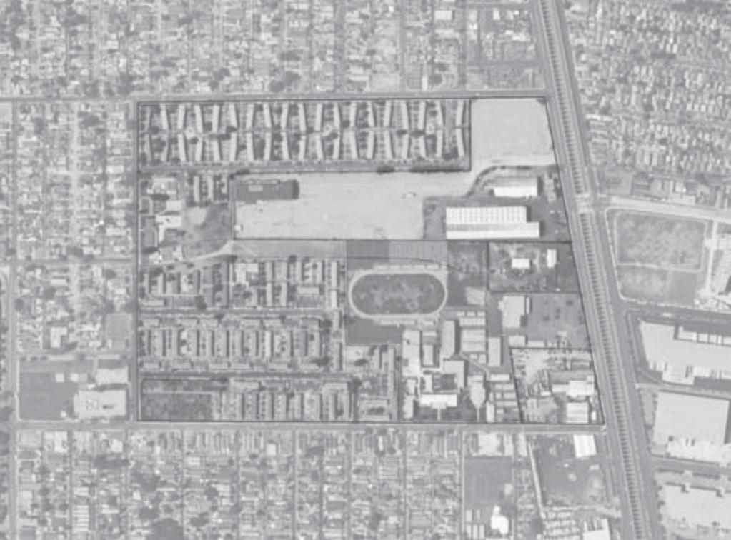
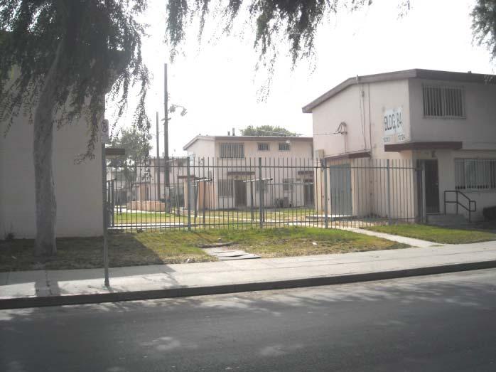
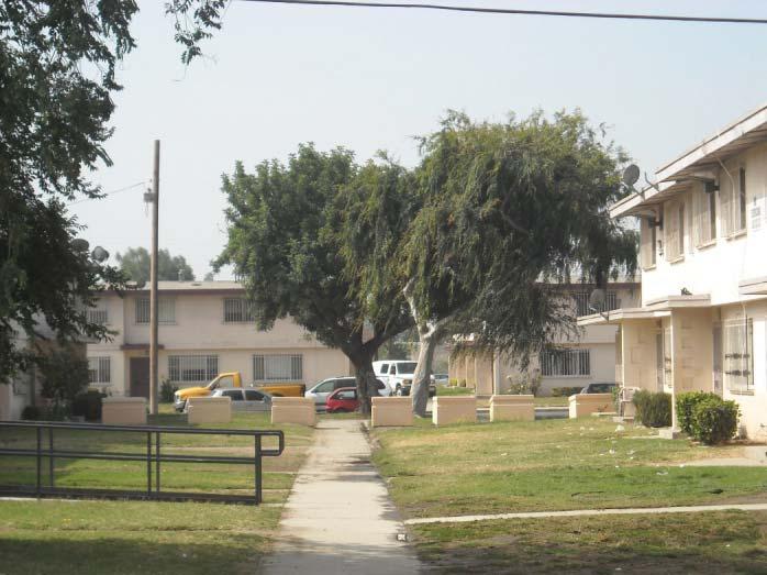
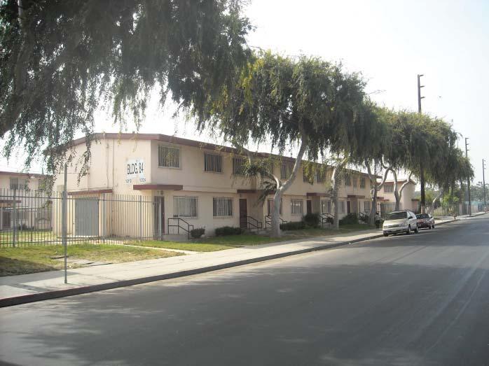
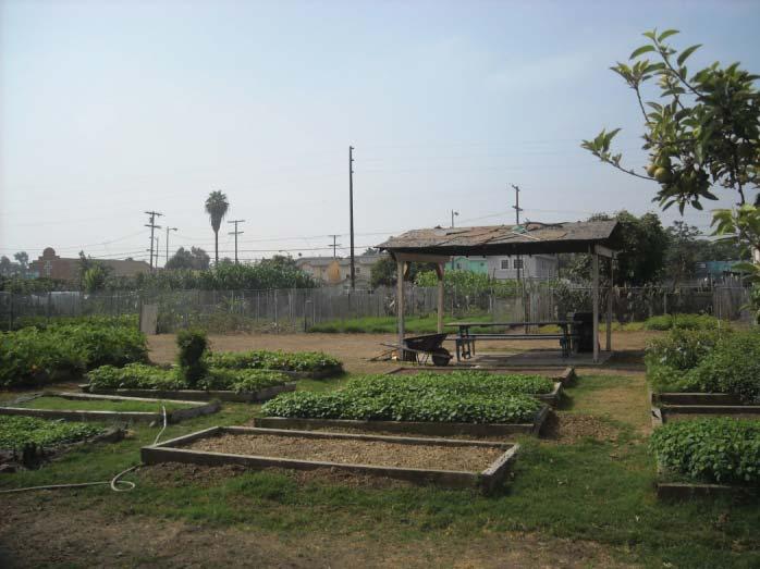
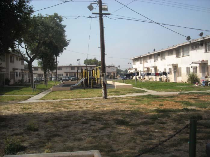
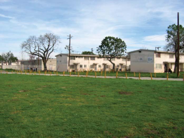
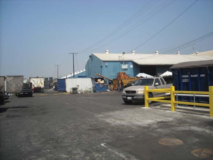
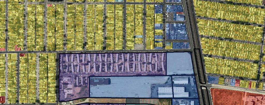
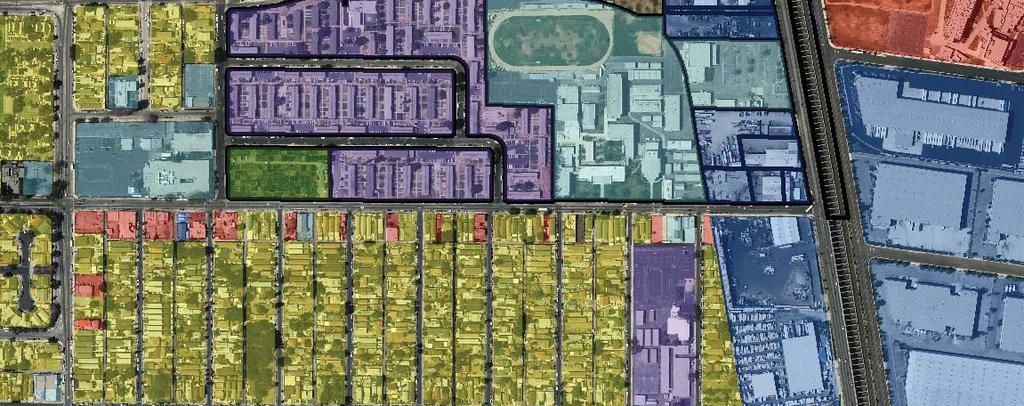
1 IV.J LAND USE AND PLANNING INTRODUCTION This section examines the proposed project to determine whether it would be consistent with local and regional land use plans and policies, and analyzes potential conflicts between existing and proposed land uses in and around the Specific Plan area. Specifically, this section evaluates the proposed project s consistency with the City of Los Angeles Planning and Zoning Codes, General Plan, and Southern California Association of Governments (SCAG) planning documents. Local policies for land use and development, such as specific plans, regulate the types of uses allowed, height, and building envelope, as well as the intensity of development. The purpose of this section is to provide baseline data on the existing land use characteristics of the Specific Plan area, including the annexation of acres of unincorporated Los Angeles County land. As new development results in changes to land use patterns, the character of an area can be affected and impacts to the environment may occur. Consistency of the proposed project with the South Coast Air Quality Management District (SCAQMD) Air Quality Management Plan (AQMP) is discussed in Section IV.C Air Quality. ENVIRONMENTAL SETTING The Specific Plan area is located in the Watts neighborhood of Los Angeles, approximately eight miles south of downtown Los Angeles and approximately one mile north of the Glenn Anderson Freeway (I- 105). The Specific Plan area contains approximately acres of land area, inclusive of streets, and is generally bounded by 97 th Street to the north, Alameda Street to the east, 103 rd Street to the south, and Grape Street to the west. The majority of the Specific Plan area is within the Southeast Los Angeles Community Plan Area (CPA) of the City of Los Angeles; however, the Specific Plan area is located at a nexus of several different local jurisdictions, including the cities of Lynwood and South Gate and the unincorporated areas of the County of Los Angeles. Approximately acres of the Specific Plan area are within the unincorporated County of Los Angeles Florence-Firestone community. Figure IV.J-1 shows the regional location, the Specific Plan area and annexation areas, and the surrounding jurisdictions. City of Los Angeles Jordan Downs Public Housing Complex. The Jordan Downs public housing complex is approximately 49.5 acres in size and includes 700 residential units, owned by the Housing Authority of the City of Los Angeles (HACLA). All of the Jordan Downs residences are in attached, two-story, townhouse-style buildings originally intended as military work-force housing. These buildings are made of a concrete block foundation and painted in a cream color with red/rust trim. The 400 residences located between 97 th and 99 th Streets were constructed in 1943 and converted to public housing in the early 1950s. An additional 300 units were added to the public housing complex in 1954 directly to the south of the 400 original units. The 700 residences provide a total of 1,791 bedrooms in 81 one-bedroom units, 257 twobedroom units, 276 three-bedroom units, 62 four-bedroom units, and 24 five-bedroom units. The residences have both front and rear entrances accessed by walkways. The front entrance walkway is typically shared by two units. The fronts of the units contain turf and in some units, large trees. Each rear entrance has its own walkway, which includes metal poles with clothes-lines for outdoor drying. Play structures and picnic areas are located between the rear entrances. There are ten of these play/picnic areas within the Jordan Downs public housing complex. No private yard space is provided for any of the units at the Jordan Downs public housing complex. Figures IV.J-2 and IV.J-3 show street-level views of the existing uses on the Specific Plan area. IV.J-1
2
3
4
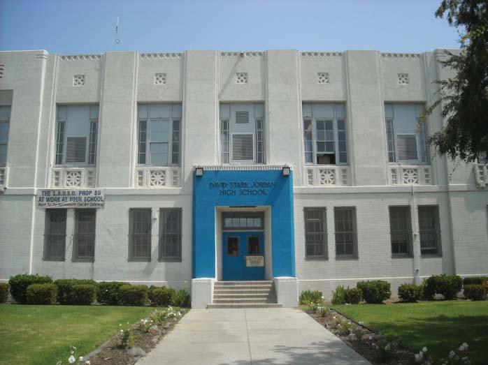
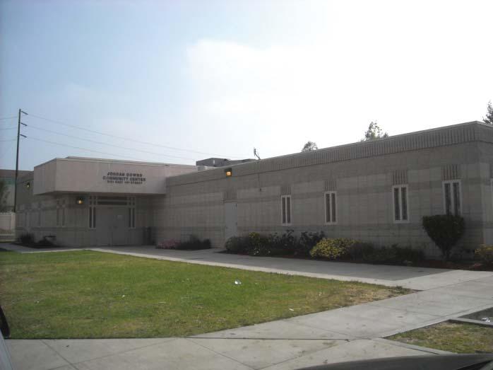
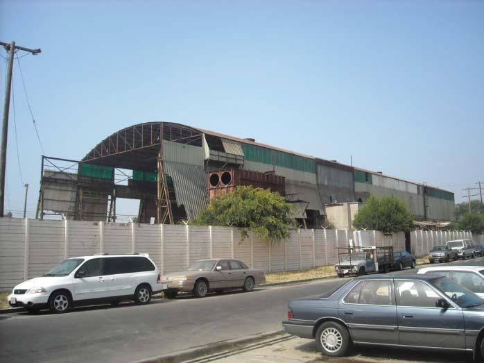
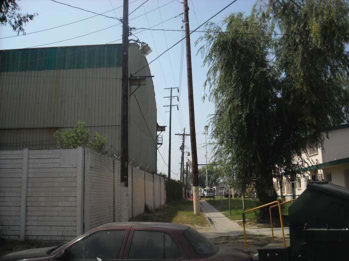
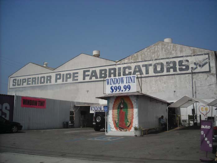
5 Jordan Downs Recreation Center. The Jordan Downs Recreation Center, which is located at 9900 Grape Street, is situated in the center of the Jordan Downs public housing complex and separates the 400 residences that were constructed in 1943 from the 300 residences to the south that were constructed in The recreation center is the main City-owned open space for the residents of the Jordan Downs public housing complex and the larger Watts community. The Jordan Downs Recreation Center includes a children s playground, picnic tables, barbecue pits, a baseball field, outdoor basketball courts, an indoor gymnasium, and a Teen Center and is operated by the City of Los Angeles Department of Recreation and Parks (LARAP). The Jordan Downs Recreation Center also provides social services and outreach to the residents of both the Jordan Downs public housing complex and of Watts. The Jordan Downs Community Advisory Council, which is made of up local residents and stakeholders, hold monthly meetings at the Jordan Downs Recreation Center to provide outreach to residents and communicate their concerns to HACLA. The Jordan Downs Recreation Center also has a work source center, and serves as a meeting place for other events and activities. David Starr Jordan High School. David Starr Jordan High School, which is located at 2265 East 103 rd Street, is owned and managed by the Los Angeles Unified School District (LAUSD). The 20-acre Jordan High School property is located adjacent to the Jordan Downs public housing complex to the south. Access to Jordan High School is off of the main entrance on 103 rd and the school parking lot on Alameda Street. Jordan High School was founded in 1923 and was reconstructed as a Works Projects Administration (WPA) project in the late 1930s. Jordan High School has athletic fields and sports courts which are not currently accessible by the residents of the Jordan Downs public housing complex. Mudtown Farms. Mudtown Farms is a 2.5-acre community garden, consisting of 124 plots tended to by 118 local residents, most of whom live in the Jordan Downs public housing complex. Mudtown Farms is located at the southwest corner of the Specific Plan area, at the northeast corner of the Grape Street/103 rd Street intersection. The community garden is owned by the Trust for Public Land and the Watts Labor Community Action Committee (WLCAC). County of Los Angeles Jordan Downs Annexation Area. The annexation area includes a 21-acre property that HACLA purchased in 2008 adjacent to the Jordan Downs public housing complex, all of the public and privately owned parcels along the Alameda Street, and right-of-way parcels, including the Alameda Corridor and portions of portions of 97 th, 103 rd, and Alameda Streets. The annexation area consists of 16 parcels of land totaling acres including 5.71 acres of right-of-way, for a total of acres of land. HACLA-Owned Properties. In April 2008, HACLA purchased three parcels of land totaling approximately 21 acres adjacent to the north and east of the Jordan Downs public housing complex. A steel mill formerly occupied the entire 21-acre site from the 1940s until the 1980s. The site is currently vacant with an abandoned steel mill structure located in the northwest corner. A truck driving training school will temporarily occupy the southeast corner of this property until construction of the proposed project begins. The truck driving school will consist of a temporary building, above-ground planter boxes, a parking lot, and above-ground utilities. Privately-Owned Properties. Based upon a preliminary review of the annexation proposal for the 21-acre property that HACLA purchased, the Local Agency Formation Commission (LAFCO) for the County of Los Angeles recommended that the City of Los Angeles also pursue the annexation of 13 additional public- and privately-owned parcels along Alameda street to create a linear boundary between the cities of Los Angeles, South Gate, and Lynwood, and reduce the cost of providing services to these parcels. The industrial parcels to the north of the LAUSD-owned parcel are currently developed with two structures and a storage yard that is occupied by Atlas Iron and Metal Company, a recycling facility. The IV.J-5
6 industrial parcels to the south are currently occupied by three light industrial structures with associated yards and parking areas. LAUSD-Owned Parcel. The LAUSD-owned parcel fronting Alameda Street is approximately 3.36 acres and is currently occupied by a number of school buildings and surface parking. This parcel separates two groupings of privately-owned properties occupied with industrial uses.. Surrounding Land Uses The Specific Plan area is surrounded by a residential neighborhood consisting primarily of one- or twostory single-family residences with narrow one-way streets to the north, west, and south. The east, facing Alameda Street, is mainly industrial, and severed from the adjoining communities by the ten-mile long Alameda Corridor railroad trench that allows the frequent passage of the 40 to 50 long-distance freight trains traveling each day from the Ports of Long Beach and Los Angeles to bypass the site. Tweedy Avenue, located immediately to the east of the project site, is the nearest location for a road crossing over the railroad trench, which occur approximately every half-mile. Figures IV.J-4 and IV.J-5 show the existing land uses and General Plan land use uses for the Specific Plan area. When Jordan Downs was platted in the 1950s, a 114-foot-wide Class II Highway right-of-way was left undeveloped for a future extension of Century Boulevard across part of the project site. Century Boulevard only developed as a major highway with the development of Los Angeles International Airport eight miles to the west. Its extension to Alameda Street and Tweedy Avenue was never constructed and Century Boulevard (currently, the easement is not lined up with Tweedy Blvd.), was narrowed to a 60-foot wide neighborhood street two blocks before the project site, between Wilmington Avenue and Grape Street. The street network of the Jordan Downs public housing complex does not integrate the public housing into the surrounding neighborhood. Whereas the neighborhoods to the north and south are oriented on a north-south street grid, the Jordan Downs public housing blocks are oriented with an east-west street grid, resulting in a lack of connectivity with the surrounding neighborhood. The entire Jordan Downs public housing complex site is also fenced, making access from the adjacent neighborhoods difficult and uninviting. The residential neighborhoods to the north, west, and south are characterized by long rectangular blocks, typically 275 to 300 feet wide and over 800 feet long, served by narrow 20-foot-wide mid-block alleys, with 25- to 50-foot-wide single-family and low-density multi-family lots. The neighborhood streets are typically 50 to 60 feet wide, with a 30- to 40-foot curb-to-curb dimension and 10-foot-wide sidewalks on either side. Most neighborhood streets have parallel parking on both sides. Many of the residences have front-accessed driveways leading to side-drives, garages or car ports, so that the sidewalks have frequent curb-cuts and reduced on-street parking, especially because many of the blocks are divided into the minimum 25-foot-wide residential lots. The Jordan Downs public housing units have an average density of 14 dwelling units (DUs) per acre. Residential uses to the north and south of the Specific Plan area are on small lots, approximately 3,375 square feet and have similar average densities of approximately 13 DUs per acre. Residential uses to the west of the Specific Plan area are on approximately 6,600-square-foot lots and have average densities of approximately seven DUs per acre. IV.J-6
7
8
9 General Plan Land Use and Zoning The portion of the Specific Plan area located within the City of Los Angeles has land use designations of Residential Low Medium II and Public Facilities, as designated by the Southeast Los Angeles Community Plan, which serves as the General Plan Land Use Element for this portion of the City of Los Angeles. The portion of the Specific Plan area located within the City of Los Angeles is zoned RD2-1, Restricted Density Multiple Dwelling Zone and PF-1, Public Facilities Zone, both with Height District 1. Under the RD2-1 designation, a minimum 2,000 square feet of lot area is required per DU. This restriction results in a maximum of 22 DUs per acre. Uses allowed in the RD2-1 zone, include residential parks, playgrounds, community centers, and home occupation uses. Residential buildings within the RD zones and Height District 1 are restricted to a maximum height of 45 feet and 3:1 floor area ratio (FAR.). The David Starr Jordan High School site is zoned PF-1. The PF zone allows for agricultural, government, school, public services, and similar uses. Buildings within the PF zone and Height District 1 are restricted to 3:1 FAR, but height itself is not restricted. The portion of the Specific Plan area located in the County of Los Angeles has a General Plan land use designation of Industrial and is zoned M-2, Heavy Manufacturing Zone. This zone allows for a wide range of uses, except some heavy industries which require a conditional use permit. Residential uses and schools are prohibited within this zone. These properties are also subject to the limitations of the Florence-Firestone Community Standards District. There is a minimum required lot area of 15,000 square feet and height is restricted by the FAR, which is limited to 13:1. Los Angeles County is in the process of preparing the Florence-Firestone Community Plan, which is intended to provide detailed land use, transportation, and urban design regulations to guide new development within this area. Surrounding Uses and Zones Parcels to the north of the Specific Plan area are Low-Density Residential and are zoned R1-1, One- Family Dwelling, in the City of Los Angeles and R3, Limited Multiple Residence, and M-1, Light Manufacturing in the County of Los Angeles. The R1-1 zone is limited to a FAR of 3:1 and a density of nine DUs per acre and the R-3 zone is limited to a density of 30 DUs per acre. Residential buildings in the R1-1 zone are limited to a height of 33 feet and to a height of 35 feet in the R-3 zone. Parcels to the west of the Specific Plan area along Grape Street and Anzac Avenue are designated Low Medium I Density Residential and are zoned R2-1, Two-Family Dwelling. The R2-1 zone is limited to a FAR of 3:1 and a density of 17 DUs per acre and a height of 33 feet. Parcels to the west of the Specific Plan area along Century Boulevard and Wilmington Avenue are designated Medium-Density Residential and are zoned R3-1, multiple dwelling. The R3-1 zone is limited to a FAR of 3:1, a density of 54 DUs per acre and a height of 45 feet. The property to the west of the Specific Plan area along Grape Street between 102 nd and 103 rd Streets is designated Public Facilities, is zoned PF-1, and is occupied by the Florence Griffith Joyner Elementary School. Figure IV.J-5 above, also shows the existing zoning designations for the Specific Plan area and surrounding areas. A few individual parcels on 103rd and Grape Streets currently hold the R4 zoning designation. These parcels are church sites and their zoning designation is further regulated by a qualified condition, otherwise known as a Q-Condition. These Q-conditions are adopted by ordinance for specific blocks to take certain existing conditions, uses, or trends under consideration, and apply additional development standards/restrictions for these blocks. The R4 zoning would revert to the nearest adjacent zoning with any future change of use. There are no true R4 residential zones located in the vicinity of the project site. Commercially-zoned parcels on Wilmington Avenue are restricted in height to three stories or 45 feet by a Q-condition. A Q-condition limits residential development on commercial zones at Century Boulevard and Compton Avenue to the R3-density. All commercial zones within Height District 1, including the Martin Luther King Shopping Center at 103 rd Street and Compton Avenue, are restricted to a FAR of 1.5:1. IV.J-9
10 Applicable Plans and Policies General Plan The General Plan is the basic planning document of a city or county and acts as a blueprint for development. Every city and county must adopt a general plan with seven mandatory elements: land use, circulation, housing, conservation, open space, noise, and safety. Depending on the community s location, general plans also contain special topics, including local coastal plans, waste management, hazardous waste, seismic hazards, floodplain management, and airport land use. The City of Los Angeles General Plan. The City of Los Angeles General Plan is a comprehensive, long-term declaration of purposes, policies and programs for the development of the City of Los Angeles. It sets forth goals, objectives and programs to provide a guideline for day-to-day land use policies and to meet the existing and future needs and desires of the community, while integrating a range of Statemandated elements including Transportation, Noise, Safety, Housing, and Conservation. The City of Los Angeles General Plan includes the following eight elements: Framework Element Housing Element Infrastructure Element Cultural Element Land Use Element Public Facilities and Service Systems Element Environmental Element Safety Element The Framework Element establishes the conceptual basis for the General Plan of the City. The Land Use Element consists of 35 Community Plans and the Airport and Harbor Plans. The Environmental Element includes the Conservation, Open Space, Air Quality and Noise Plans. County of Los Angeles General Plan. Los Angeles County is one of the nation's largest counties, encompassing approximately 4,081 square miles. It is bounded on the east by Orange and San Bernardino Counties, on the north by Kern County, on the west by Ventura County, and on the south by the Pacific Ocean. There are 88 cities within the County, each with its own city council. As stated earlier, approximately acres of the project site are within unincorporated Los Angeles County under the Florence-Firestone Community Plan area. Other Local Plans and Policies Los Angeles Municipal Code. Chapter 1 of the City of Los Angeles Municipal Code (LAMC) contains the City s Planning and Zoning Code. The Planning and Zoning Code sets forth developments standards and regulations for the City s designated land use zones, and was drafted to designate, regulate, and restrict the location and use of buildings, structures,and land for agriculture, residence, commerce, trade, industry, or other purposes. The LAMC seeks to encourage the most appropriate use of land, conserve and stabilize the value of property, provide adequate spaces for light and air, prevent and fight fire, prevent undue concentration of population, lessen congestion on streets, facilitate adequate provisions for community utilities and facilities, and promote health, safety, and general welfare in accordance with the comprehensive plan. Chapter 1, Article 2, Sections and of the City of Los Angeles Municipal Code describe RAS3 and RAS4 Residential/Accessory Services (RAS) Zones, respectively. The purpose of RAS zones is to provide a mechanism to increase housing opportunities, enhance neighborhoods, and revitalize older commercial corridors. The RAS3 and RAS4 zones are intended as tools to accommodate projected population growth in mixed-use and residential projects that is compatible with existing residential neighborhoods along existing transportation corridors. City of Los Angeles Land Use/Transportation Policy. Adopted by the City Council in 1993, the City of Los Angeles and the Los Angeles County Metropolitan Transportation Authority (Metro) initiated a IV.J-10
11 cooperative planning effort to develop an integrated policy addressing land use, transportation and air quality issues related to the regional transportation system. It is a long-term strategy for integrating land use, housing, transportation, and environmental policies into the development of a city in a form or manner that complements and maximizes the utilization of the region's transit system. The Policy fosters the development of higher-density, mixed-use projects within 0.25 miles of rail and major bus facilities. Mixed-use projects generally include a combination of commercial, residential, civic, and employmentgenerating uses. Southeast Los Angeles Community Plan. The Land Use Element of the City of Los Angeles uses Community Plans that establish policy and standards for each of the 35 geographic areas in the City. As such, the Community Plans are oriented toward specific geographic areas of the city, defining locally the General Plan s more general citywide policies and programs. The Southeast Community Plan (adopted March 2000) addresses the general land use guidelines that affect the project site and the surrounding area. The purpose of the Community Plan is to provide an official guide to the future development within the Plan area. The Community Plan promotes an arrangement of land use, circulation, and services that encourage and contribute to economic, social and physical health, safety, welfare, and convenience of the community. Additionally, it guides the development, betterment, and change of the community to meet existing and anticipated needs and conditions; balance growth and stability and land development trends. The Southeast Community Plan has the intended purpose of providing for the proper location of a range of land uses and physical development, to be carried out in a manner consistent with the designated purposes of the Plan. The current land use designations for the existing housing complex in the Specific Plan area under the Southeast Community Plan are Restricted Density Multiple Dwelling and Public Facilities. Conditional Use Approval for Sale of Alcohol Specific Plan. The Southeast Los Angeles CPA contains a disproportionately large number of establishments selling alcoholic beverages which may contribute to health, safety, and general welfare problems in the area. The existence of such problems creates serious impacts on the health, safety, and welfare of residents of nearby single- and multiplefamily areas. This Specific Plan was adopted in 1987 and most recently revised in 1997 to regulate and restrict the development of these land uses. The Specific Plan area encompasses all of the Southeast Los Angeles CPA. Watts Corridors Redevelopment Project. The existing Watts Corridors Recovery Redevelopment Project adopted on November 15, 1995 is approximately 245 acres and comprises ten non-contiguous subareas along segments of commercial corridors in southeast Los Angeles. The expansion of this project area to approximately 2,470 acres is currently being studied. The new area is generally bounded by 92 nd Street to the north, Vermont Avenue to the west, Mona Boulevard to the east, and I-105 to the south. The expansion area includes commercial and residential areas, including the HACLA-owned Jordan Downs public housing project Los Angeles Mayor s Housing Plan. The Mayor s housing plan, Housing that Works , seeks to transform existing public housing sites into vibrant mixed-income communities. This plan seeks to replace the existing deteriorating apartments with new, modern, mixed-income residential communities funded and developed through innovative public/private partnerships. A vital component of this plan is that all projects provide one-for-one replacement of existing units while providing increased resources and opportunities for residents. County of Los Angeles Florence-Firestone Community Plan. The Florence-Firestone Vision Plan was developed between November 2008 and April of 2009 through a process of stakeholder interviews, public workshops, collaboration with County staff and an analysis of the community s existing conditions. Florence-Firestone is a 3.6-square-mile unincorporated community located approximately six IV.J-11
12 miles south of Downtown Los Angeles. The community is situated between the City of Los Angeles on the north, south, and west, and the cities of Huntington Park, South Gate and Lynwood on the east. Florence-Firestone is accessible by the Harbor Freeway (I-110) on the west, the I-105 on the south and the Santa Monica Freeway (I-10) on the north. Land uses policies are contained in the physical vision of the plan, which is a long-term strategy containing eight objectives for physical improvements within the community. The strategy includes the following seven objectives: Enhance Florence Mile as the main street of the community; Create a central area; Strengthen neighborhoods; Preserve and enhance jobs along Alameda Corridor and other industrial areas; Preserve the existing jobs and seeks ways to expand the employment base; Transform the corridors to improve the visual character and provide needed services (does not include the non-hacla lots within the proposed annexation); Expand parks and open space; and Make the transportation system safer and more efficient. The portion of the Specific Plan area located in the County of Los Angeles is along the Alameda Corridor, and is designated for the preservation and expansion of employment objective in the Florence- Firestone Vision Plan. Based upon the findings of the Vision Plan, the County will prepare the Florence- Firestone Community Plan, which will contain detailed regulations for future development within the area. Florence-Firestone Community Standards District. The Florence-Firestone Community Standards District (CSD) is contained within Section of the Los Angeles County Municipal Code. This CSD was established to improve the appearance of the community and to promote the maintenance of structures and surrounding properties. The CSD also establishes standards to improve the compatibility between residential uses and neighboring industrial uses. CSD regulations supplement the countywide zoning and subdivision regulations. Community Standards Districts are established as supplemental districts to provide a means of implementing special development standards contained in adopted neighborhood, community, area, specific, and local coastal plans within the unincorporated areas of Los Angeles County, or to provide a means of addressing special problems which are unique to certain geographic areas within the unincorporated areas of Los Angeles County. Habitat Conservation Plan or Natural Community Conservation Plan. Habitat Conservation Plans (HCPs), designated under section 10(a)(1)(B) of the Endangered Species Act, are planning documents required when a project will affect a species identified as listed, non-listed, or eligible under the act and detail how those impacts will be minimized, or mitigated; and how the HCP is to be funded. Currently, there are no species identified in the Southeast Los Angeles or Specific Plan areas that are protected by the Endangered Species Act and thus, no applicable HCPs. The Natural Community Conservation Planning program of the Department of Fish and Game takes a broad-based ecosystem approach to planning for the protection and perpetuation of biological diversity. 1 A Natural Community Conservation Plan (NCCP) identifies and provides for the regional or areawide protection of plants, animals, and their habitats, while allowing compatible and appropriate economic activity. The primary objective of NCCPs is to conserve natural communities at the ecosystem scale while accommodating compatible land use. There are currently no NCCPs for the Specific Plan area. 1 California Department of Fish and Game, Natural Community Planning Program, available at habcon/nccp/, accessed March 5, IV.J-12
13 Regional Plans SCAG Regional Comprehensive Plan, Regional Transportation Plan, and Growth Vision Report. Southern California Association of Governments (SCAG) is the regional planning agency with responsibility for reviewing the consistency of local plans, projects, and programs with regional plans. It is a federally-designated metropolitan organization for six Southern California counties, including the County of Los Angeles. As such, SCAG is mandated to create regional plans that address transportation, growth-management, hazardous waste management, and air quality. Regional Comprehensive Plan. The Regional Comprehensive Plan (RCP) is an advisory document that describes future conditions if current trends continue. It defines solutions to interrelated housing, traffic, water, air quality, and other regional challenges and is intended to provide a framework for decision making by local governments regarding growth and development. The RCP may be voluntarily used by local jurisdictions in developing local plans and addressing local issues of regional significance. RCP chapters are divided into three categories: core, ancillary, and bridge. The core chapters include Growth Management, Regional Transportation Plan (RTP), Air Quality, Hazardous Waste Management, and Water Quality. RCP ancillary chapters include the following: Economy, Housing, Human Resources and Services, Finance, Open Space and Conservation, Water Resources, Energy, and Integrated Solid Waste Management. Bridge chapters include the Strategy and Implementation chapters, functioning as links between the Core and Ancillary chapters of the RCP. Regional Transportation Plan. SCAG is mandated by the federal government to prepare the RTP every four years. The RTP was most recently updated in May The RTP provides a framework for the future development of the regional transportation system and addresses all modes of transportation within the region. The RTP policies are incorporated into the RCP. At the regional level, the goals, objectives, and policies in the RCP and RTP are used for measuring consistency with the adopted plan. Growth Vision Report. SCAG has collaborated with interdependent sub-regions, counties, cities, communities and neighborhoods in a process referred to by the SCAG as Southern California Compass, which resulted in the development of a shared Growth Vision Report for Imperial, Los Angeles, Orange, Riverside, San Bernardino, and Ventura Counties. The shared regional vision sought to address issues such as congestion and housing availability, which may threaten the regions livability. Principles established by the Growth Vision Subcommittee are intended to promote and maximize regional mobility, livability, prosperity and sustainability. Decisions regarding growth, land use, transportation and economic development should support and be guided by these principles. State Enterprise Zone. California Enterprise zones were created to promote local job growth, and to retain and attract new businesses in economically distressed areas of California. Determination of eligibility rests with the State Department of Housing and Community Development. Currently, there are 42 Enterprise Zones in the State. The Specific Plan area is located within the Los Angeles SEZ, which was designated by the State on October 15, 2006, and is valid through October 15, Businesses located within a California Enterprise Zone are eligible to claim numerous tax credits designed to stimulate business growth. ENVIRONMENTAL IMPACTS Significance Thresholds In accordance with Appendix G of the State CEQA Guidelines, the proposed project would have a significant impact on land use and planning if the proposed project were to: Physically divide an established community; IV.J-13
14 Conflict with any applicable land use plan, policy, or regulation of an agency with jurisdiction over the project (including, but not limited to, the general plan, specific plan, local coastal program, or zoning ordinance) adopted for the purpose of avoiding or mitigating an environmental effect; and/or Conflict with any applicable Habitat Conservation Plan or Natural Community Conservation Plan. Project Design Features Implementation of the Specific Plan would include the demolition and reconstruction of the existing Jordan Downs public housing complex to include up to 1,800 new residential units built in a variety of residential building types. In addition, up to 210,000 gross square feer (gsf) of commercial and retail space could be developed along Alameda Street, plus up to 20,000 gsf of community-serving retail and services in mixed-use buildings on HACLA-owned property. An additional 292,000 gsf of commercial and light industrial uses could also potentially be developed on the LAUSD- and privately-owned parcels along Alameda Street (Table IV.J-1). The HACLA-owned properties are currently developed with 138,000 gsf of industrial land uses. Similarly, the privately-owned properties are presently developed with 292,000 gsf of industrial land uses. Therefore, implementation of the proposed project would result in the addition of 260,000 gsf of new employment uses. Similarly, the existing Jordan Downs Recreation center, which is approximately 7,000 gsf, would be replaced with a new Family Resource Center. Therefore, implementation of the proposed project would result in the addition of 63,000 gsf of additional community facilities. The Specific Plan also identifies two potential locations for a new elementary school and an expansion to Jordan High School which could accommodate up to 1,400 additional students. In addition, there are currently 3.16 acres of parks and open space areas associated with the existing recreation center. Therefore, implementation of the proposed project would provide an additional 5.79 acres of parks and public open space. The proposed site plan depicting the implementation of the Specific Plan as envisioned in the Master Plan is presented in Figure IV.J-6. The proposed project is organized around a new central park and the Family Resource Center, which would be home to HACLA programs and community services, within heart of the Specific Plan area. Entitlements Annexation. The proposed project consists of both the adoption and implementation of the Specific Plan, and the annexation of acres of land from the County of Los Angeles to the City of Los Angles. Table IV.J-2 identifies the assessor parcel numbers, owners, and size of the annexation area properties. Tract Map. The tract map for the Specific Plan area would need to be redefined with the new parcel and street boundaries. IV.J-14
15 TABLE IV.J-1: SPECIFIC PLAN PROGRAM SUMMARY Uses Residential (Multi-Family) Rentals (includes 100 senior units) Condominiums Total Residential Commercial/Retail/Light Industrial (Employment Uses) HACLA-Owned Properties Commercial/Retail Mixed Use (Community Serving Retail and or Services) LAUSD and Privately-Owned Properties Commercial/Light Industrial Total Employment Community Facilities Family Resource Center Gymnasium Pool Total Community Facilities Schools Elementary School High School Expansion Total School Parks and Public Open Spaces Central Park Other Open Space and Plazas Total Parks and Public Open Spaces SOURCE: WRT Solomon E.T.C. No. of Units, Size, or No. of Students 1,400 Units 400 Units 1,800 Units 210,000 gsf 20,000 gsf 292,000gsf 522,000 gsf 50,000 gsf 17,000 gsf 3,000 gsf 70,000 gsf 650 Students 750 Students 1,400 Students 6.38 acres 2.57 acres 8.95 acres TABLE IV.J-2: ANNEXATION AREA PROPERTIES Assessor Parcel Number (APN) Owner Size (Acres) HACLA HACLA HACLA Gary Weisenberg Family Trust/10019 S Alameda Gary Weisenberg Family Trust Gary Weisenberg Family Trust John Hook Robert Moehlman Northern Trust Robert Moehlman Robert Moehlman LAUSD City of Long Beach City of Los Angeles City of Los Angeles City of Long Beach 2.89 N/A Right-Of-Way 5.71 TOTAL SOURCE: Hogle-Ireland, IV.J-15
")

16 ALAMEDA ST ST New Homes 97TH ST New Family Resource Center Possible Elementary School Site New Retail/ Employment Freedom Tree Park CENTURY BLVD Central Park CENTURY EXTENSION TWEEDY BLVD New Joint-Use Gym Pool Facility GRAPE ST Possible High School Expansion Site ALAMEDA TRENCH/CORRIDOR(BNSF&UPRR) TRENCH/CORRIDOR(BNSF&UPRR) Employment Parcel 103RD ST 103rd Street Retail Plaza 1 N LEGEND: Specific Plan Area SOURCE: WRT/Solomon E.T.C., Jordan Downs Specific Plan Environmental Impact Report CITY OF LOS ANGELES DEPARTMENT OF CITY PLANNING APPROX. SCALE FEET FIGURE IV.J-6 PROPOSED SITE PLAN
17 Reclassification of Century Boulevard. Century Boulevard is an east-west road classified as a Major Highway Class II in the City of Los Angeles Transportation Element. Currently, Century Boulevard is a four-lane roadway west of Wilmington Avenue, and a two-lane roadway from Wilmington Avenue to its termination at Grape Street. Under the Specific Plan, Century Boulevard would be extended from Grape Street eastward, curving around the new central park (new alignment from existing easement), ultimately connecting at the project site s eastern edge with Tweedy Boulevard where it crosses the Alameda Corridor. The Century Boulevard extension would be designed as a neighborhood center street and would therefore, need to be reclassified with implementation of the Specific Plan. Designed to be 64 feet wide, the street right-of-way would be wide enough to accommodate buses. From Laurel Street to Alameda Street, Century Boulevard would be widened to four lanes, and improvements would be made at the intersection with Alameda Street to accommodate through traffic. Most of its length would have onstreet parking along both sides. This street would be similar in design to the City of Los Angeles Department of Public Work s Standard Street design for a Non-Arterial Collector Street. Reclassification of Century Boulevard would require a General Plan Amendment and to downgrade Century Boulevard from a Major Highway Class II Arterial Street to a Collector Street from Wilmington Avenue to Grape Street, and from Grape Street to Alameda Street, and as a Modified Secondary Highway from Wilmington Avenue westerly to Success Avenue. Zoning Amendments. Section of the Los Angeles Municipal Code will be amended by adding the Specific Plan area to the zoning map and establishing the following additional zones for the Specific Plan area: 2 A (JD) Agriculture Zone OS (JD) Open Space Zone RAS3 and RAS4(JD) Residential/Accessory Services Zones R3 and R4 (JD) Multiple Dwelling Zones CM(JD) Commercial Manufacturing Zone In addition to these zones the PF Public Facilities Zone would remain. The new zoning designations established for the Specific Plan area would set limits on the allowable density and development permitted in each defined block, including limits on building heights, massing, as well as yards and setbacks. The proposed zoning designations are shown in Figure IV.J-7. The Key Plan presented in Figure IV.J-8 shows the block locations within the Specific Plan area, while Table IV.J-3 lists the existing and proposed land use and zoning designations for each block. 2 Zoning definitions and development standards are defined in the Jordan Downs Specific Plan. IV.J-17
18 RAS3-1 97TH ST CENTURY BLVD CENTURY BLVD 103RD ST WILMINGTON AVE GRAPE ST CROESUS AVE KALMIA ST WEIGAND AVE GRAPE ST CROESUS AVE KALMIA ST MISSOURI AVE GRAPE ST R3-1 R3-1 R3-1 RAS3-1 OS-1 CM-2 99TH ST TWEEDY BLVD RAS3-1 PF-1 RAS3-1 RAS3-1 R3-1 OS-1 OS-1 R ST ST R3-1 RAS3-1 RAS3-1 RAS3-1 RAS4-1 OS-1 OS-1 RAS3-1 OS-1 PF-1 PF-1 OS-1 RAS3-1 PF-1 RAS4-1 RAS4-1 OS-1 CM-2 CM-2 CM-2 ALAMEDA ST A-1 RAS3-1 RAS3-1 RAS3-1 RAS3-1 CM-2 LEGEND: Specific Plan Area Proposed Land Uses Residential Public Facilities Mixed-use Open Space Commercial Agriculture N Note: All Specific Plan zoning designations have an Urban Village, or UV suffix. Not Shown Here. SOURCE: TAHA, Industrial Jordan Downs Specific Plan Environmental Impact Report CITY OF LOS ANGELES DEPARTMENT OF CITY PLANNING Potential Expansion of School or New School, PF-1 APPROX. SCALE FEET FIGURE IV.J-7 PROPOSED LAND USE AND ZONING DESIGNATIONS
19 County of Los Angeles KANSAS AVE 97TH ST INDIANA AVE CENTURY BLVD City of Los Angeles 8 9 B C E C D A B 7 A 10 X Y B B 3 4 A A Z 2 31 TWEEDY BLVD City of South Gate 19 B A B B 30 A C 18 B A RD ST GRAPE ST HICKORY ST City of Los Angeles CROESUS AVE KALMIA ST WEIGAND AVE City of Lynwood ALAMEDA ST ALAMEDA ST LEGEND: # SOURCE: WRT/Solomon E.T.C., Specific Plan Area Annexation Area Block Number, refer to Table II-3 for the size and proposed land use and zoning of the block Jordan Downs Specific Plan Environmental Impact Report CITY OF LOS ANGELES DEPARTMENT OF CITY PLANNING N APPROX. SCALE FEET FIGURE IV.J-8 KEY MAP
20 TABLE IV.J-3: EXISTING AND PROPOSED LAND USE AND ZONING DESIGNATIONS Block Size (Acres) Existing Land Use Designation Proposed Land Use Designation Existing Zoning Proposed Zoning Industrial Commercial M-2 CM-2-UV Industrial Commercial M-2 CM-2-UV Residential Residential RD2-1 RAS3-1- UV 3A 0.4 Residential Residential RD2-1 RAS4-1-UV Industrial Residential M-2 RAS3-1- UV 4A 0.50 Industrial Residential M-2 RAS4-1- UV Residential Residential RD2-1 RAS3-1- UV Industrial Residential M-2 RAS3-1- UV Industrial Community Facility M-2 PF-1- UV 8A 0.33 Residential Residential RD2-1 RAS3-1- UV 8B 3.44 Residential Residential RD2-1 R3-1- UV 8C 0.53 Residential Open Space RD2-1 OS-1- UV X 0.25 Residential Open Space RD2-1 OS-1- UV Y 0.22 Commercial/Industrial Open Space M-2 OS-1- UV Z 0.22 Commercial/Industrial Open Space M-2 OS-1- UV 9A 0.46 Residential Residential RD2-1 RAS4-1- UV 9B 0.81 Residential Residential RD2-1 RAS3-1- UV 9C 2.36 Residential Residential RD2-1 R3-1- UV 9D 0.63 Residential Residential RD2-1 RAS3-1- UV 9E 0.95 Residential Open Space RD2-1 OS-1- UV 10A 1.45 Residential Open Space RD2-1 OS-1- UV 10B 4.93 Residential Open Space RD2-1 OS-1- UV Residential Residential RD2-1 RAS3-1- UV Residential Community Facility RD2-1 PF-1- UV Public Facility Residential PF-1 RAS3-1- UV Public Facility Residential PF-1 RAS3-1- UV Public Facility Residential PF-1 RAS3-1- UV Residential Residential/Mixed RD2-1 RAS3-1- UV Residential Residential/Mixed RD2-1 RAS3-1- UV 18A 0.34 Residential Residential RD2-1 RAS3-1- UV 18B 2.48 Open Space WLCAC (Mudtown Farms) RD2-1 A1-1- UV 19A 0.70 Residential Residential RD2-1 RAS3-1- UV 19B 3.02 Residential Residential RD2-1 R3-1- UV Residential Residential RD2-1 R3-1- UV Residential Residential RD2-1 R3-1- UV Residential Open Space RD2-1 OS-1- UV Residential Residential RD2-1 R3-1- UV Residential Residential RD2-1 RAS3-1- UV 30A Public Facility Public Facility PF-1 PF-1- UV 30B 0.77 Public Facility Public Facility M-2 PF-1- UV 30C 3.28 Industrial Public Facility RD2-1 CM-1- UV Industrial Commercial/Industrial M-2 CM-1- UV Industrial Commercial/Industrial M-2 CM-1- UV ROW ROW ROW n/a n/a Alameda ROW 3.88 ROW ROW M-2 PF-1- UV TOTAL n/a n/a UV = Jordan Downs Specific Plan suffix; A1-1 = Agricultural; RD2-1 = Restricted Density Multiple Dwelling Zone; R3-1 = Multiple Dwelling; RAS3-1/RAS4-1 = Residential/Accessory; CM2-2= Commercial Manufacturing; M-2 = Heavy Manufacturing Zone; and PF-1 = Public Facilities Zone. SOURCE: WRT Solomon E.T.C. and City of Los Angeles Department of City Planning, January IV.J-20
21 Architectural Design Guidelines The architectural guidelines for the Specific Plan define the specific architectural tools that should be used by architects, developers, and the community to create and assess architectural compatibility between buildings within the Jordan Downs community, and compatibility between these new buildings and the buildings and places of the surrounding area. The Architectural Design Guidelines have the following goals: Relate the scale of new buildings to the existing community; Orient new buildings to pedestrians; Ensure that new buildings and residences are ground-related; Provide a range of unit types; Create a vibrant urban village; and Express region-related architectural character and identity. Open Space A new central park would be the center of a network of parks, greenways, and other open spaces for use by the residents and the Watts community. The central park would be over six acres in size, and would include a variety of passive and active recreational areas. The central park would be the symbolic front lawn of the new Family Resource Center and would be lined with mixed use residential buildings and community amenities, including a new community center and a joint-use gymnasium. The Freedom Tree is a community landmark that would be protected as an important cultural feature. Freedom Tree Park would provide areas for passive recreation and would reflect the cultural heritage of the community. The park would be designed to support passive activities such as walking, picnicking, grilling, reading, etc. Plazas, which would be primarily comprise hardscape surfaces, would be incorporated to provide areas for civic engagement and commercial activity. Adjacent buildings would orient entrances toward the plazas to create active urban spaces and connections between indoor and outdoor spaces. The plazas would include enhanced paving and landscape as well as safe street crossings, benches, ample lighting, litter receptacles/ash urns, etc. The Specific Plan identifies two potential locations for a new elementary school and an expansion to Jordan High School. If either of these school options are implemented, the total number of residential units would remain the same; however, the 1,600 to 1,800 residential units would redistributed more densely over the project site. Joint use of school fields and playgrounds would play an integral role in the open space strategy. Joint-use facilities would provide the community with broader, more balanced opportunities for active recreation. Circulation/Mobility Street Types and Network Connections. The proposed project would include a neighborhood pattern of streets that reconnect Jordan Downs with the surrounding neighborhood. The existing fencing surrounding Jordan Downs would be removed and new streets would lead into and through the project site, some of them aligning with existing streets outside the Specific Plan area, allowing for the community to be connected with Watts. The new street network would be lined on both sides with a continuous network of sidewalks and walkways. The sidewalks would vary in width and design according to their location in the project site and anticipated uses. The network of sidewalks would allow for multiple routes to get to and from destinations, allowing for variety and safety, with homes overlooking the public walkways. As mentioned previously, Century Boulevard would be extended from Grape Street eastward, curving around the new central park and connecting at the project site s eastern edge with Tweedy Boulevard where it crosses the Alameda Corridor. The typical residential street is the street design most commonly IV.J-21
22 planned for use throughout the project site. Typical residential streets would be 60 feet wide and generally lined with two- to four-story residential buildings on both sides. Most of the residential streets are continuously lined with sidewalks, street trees, and on-street parking along both sides. Pedestrian safety and traffic-calming measures at intersections include stop signs and sidewalk bulb-outs. This street would be similar in design to the Standard Street design for a Non-Arterial Local Street. Typical residential streets would have a ten-foot setback from the public right-of-way intended to accommodate front door entrances, stoops, porches and outdoor landscaping and patio spaces. Frequent entrances replicate the pattern of traditional neighborhoods and enliven the streetscape. The ground units of multi-story stacked residential buildings are encouraged to have entrances directly from the street in addition to any entrances from the building corridors or parking garages. Parking. Off-street parking for the residential uses would be accommodated in three ways: 1) in shared parking courts, 2) in individual garages attached to the dwelling, and 3) in congregate garages below stacked units. Congregate garages would typically be located either in a partial basement or at grade with units at the perimeters, facing the surrounding streets. Individual garages would be accessed from the mid-block lane or from at-grade car courts, allowing residents to walk up from the garage to their units. With congregate garages, access to the dwelling units from parking would be via elevators and corridors, and to the rear of storefronts when designed with mix-use. Private parking would be accommodated at a rate of 1.5 parking spaces per residential unit. Visitor parking would be accommodated on-street. Implementation of the proposed project would also include one off-street parking space for every 200 square feet of gross floor area for any restaurant, coffee shop, or similar establishment. Larger retail establishments, above 1,000 square feet would provide a minimum of three off-street parking spaces for each 1,000 square feet of gross floor area. Sustainability The sustainability goals that have been incorporated into the Specific Plan include: Appropriate building massing and density to create a human-scaled community that relates to the scale of the surrounding communities; Walkable, pedestrian-friendly streets to promote socializing and physical activity; Significant reduction in potable water used for irrigation through native and drought-tolerant plants and drip irrigation; Reduction of the heat island effect through appropriate placement of trees to provide shading to hardscape areas that are prone to collect heat; Stormwater retention to reduce stormwater runoff and pollutants; Stormwater retention tanks will provide irrigation to landscaping, thus potentially reducing some landscaped areas of the project site to no potable water use for irrigation; On-site renewable energy source implemented as solar hot water panels on the rooftops to provide domestic hot water; Reduce energy consumption of infrastructure of the project by providing energy-efficient street lights and traffic lights; Reuse of existing material on site for building new infrastructure, including crushing of existing asphalt paving and concrete sidewalks to be reused in new infrastructure; Incorporate Bike Plan Strategies. Analysis of Proposed Project Impacts Division of an Established Community. The existing Jordan Downs public housing complex, similar to other public housing projects, is a distinct land use with differing physical aspects within the Watts IV.J-22
APPENDIX D: BACKGROUND AND VISION
 APPENDIX D: BACKGROUND AND VISION BACKGROUND A. Specific Plan Location Jordan Downs is located at 9800 Grape Street in Los Angeles, California, 90002. The Jordan Downs Urban Village Specific Plan area
4. ENVIRONMENTAL IMPACT ANALYSIS 7. LAND USE AND PLANNING
 4. ENVIRONMENTAL IMPACT ANALYSIS 7. LAND USE AND PLANNING 4.7.1 INTRODUCTION The following analysis discusses the consistency of the Proposed Project with the corresponding land use and zoning designations
IV.A AESTHETICS INTRODUCTION
 IV.A AESTHETICS INTRODUCTION This section addresses the potential impacts to visual character, views and vistas, scenic resources, light and glare, and shadows that could result from the implementation
The transportation system in a community is an
 7 TRANSPORTATION The transportation system in a community is an important factor contributing to the quality of life of the residents. Without a sound transportation system to bring both goods and patrons
5.9 LAND USE Existing Conditions Historic Land Use Trends Existing Land Use Distribution
 5.9 LAND USE This section describes the existing land use pattern and land use planning/regulatory framework in the City of Fontana. It also evaluates potential long-term land use impacts such as physically
4.1.3 LAND USE CATEGORIES
 4.1.3 LAND USE CATEGORIES a. City Center District The City Center District incorporates the existing character and mix of uses in downtown Belmont to encourage redevelopment and new development in keeping
3.10 LAND USE SETTING PROJECT SITE EXISTING LAND USE DESIGNATIONS AND ZONING. General Plan Land Use Designations.
 This section of the Draft EIR addresses the existing land uses on and adjacent to the project site and discusses the potential impacts of the proposed project on existing land uses. Key issues addressed
Staff Report and Recommendation
 Community Planning and Development Planning Services 201 W. Colfax Ave., Dept. 205 Denver, CO 80202 p: 720.865.2915 f: 720.865.3052 www.denvergov.org/cpd TO: City Council Neighborhoods and Planning Committee
Gold Line Bus Rapid Transit Transit Oriented Development (BRTOD) Helmo Station Area Plan
 Helmo Station Area Plan") Appendix F Gold Line Bus Rapid Transit Transit Oriented Development (BRTOD) Helmo Station Area Plan Introduction and Purpose of the Plan The Gold Line Bus Rapid Transit facility is an eleven-mile dedicated
Appendix F Gold Line Bus Rapid Transit Transit Oriented Development (BRTOD) Helmo Station Area Plan Introduction and Purpose of the Plan The Gold Line Bus Rapid Transit facility is an eleven-mile dedicated
CHAPTER 3 VISION, GOALS, & PLANNING PRINCIPLES. City of Greensburg Comprehensive Plan. Introduction. Vision Statement. Growth Management Goals.
 CHAPTER 3 VISION, GOALS, & PLANNING PRINCIPLES Introduction The Greensburg Comprehensive Plan is intended as a working community document. A combination of long and short-term goals, this document is intended
Transportation. Strategies for Action
 Transportation A major priority for the Overlake Neighborhood is to develop a multimodal transportation system. To achieve this system, a balance has to be found among travel, circulation and access needs;
Wadsworth Boulevard S TAT I O N A R E A P L A N
 Wadsworth Boulevard S TAT I O N A R E A P L A N City of Lakewood Adopted November, 2006 The Vision The City of Lakewood s overall vision is to transform the area around the light rail station into a mixed-use
Neighborhood Districts
 NEIGHBORHOOD DISTRICTS SEVEN MAIN DISTRICTS Neighborhood Districts While the Development Plan provides a broad-scale overview of the neighborhood, this section focuses on uses and relationships at the
FRUITVALE TRANSIT VILLAGE (Phase 2) Residential Project
 Residential Project") FRUITVALE TRANSIT VILLAGE (Phase 2) Residential Project DEVELOPER: SIGNATURE PROPERTIES ARCHITECT: HKIT ARCHITECTS April 23, 2010 TABLE OF CONTENTS 3 Vision 4 Description of Site 5 Guiding Concepts 6
FRUITVALE TRANSIT VILLAGE (Phase 2) Residential Project DEVELOPER: SIGNATURE PROPERTIES ARCHITECT: HKIT ARCHITECTS April 23, 2010 TABLE OF CONTENTS 3 Vision 4 Description of Site 5 Guiding Concepts 6
Lehigh Acres Land Development Regulations Community Planning Project
 Lehigh Acres Land Development Regulations Planning Effort Summary In July, 2010 Commissioner Frank Mann invited the Lehigh Acres community to start discussing how to achieve their recently adopted community
Hockessin Community Redevelopment Plan
 Hockessin Community Redevelopment Plan 3.1 Introduction The Community Redevelopment Plan for the Village of Hockessin is the result of the people s vision for a distinct village center that serves as the
Sheridan Boulevard S TAT I O N A R E A P L A N S H E R I D A N B O U L E VA R D S TAT I O N A R E A P L A N
 Sheridan Boulevard S TAT I O N A R E A P L A N 1 City of Lakewood Adopted November, 2006 S H E R I D A N B O U L E VA R D S TAT I O N A R E A P L A N The Vision The City of Lakewood s overall vision is
CITY OF CLEVELAND GREEN DESIGN GUIDELINES
 CITY OF CLEVELAND GREEN DESIGN GUIDELINES SEPTEMBER 18, 2008 PROJECT COMPLIANCE PATH: 1. Approved master plan 2. Approved design district boundaries 3. Approved district design guidelines, Green design
Corridor Vision. 1Pursue Minnehaha-Hiawatha Community Works Project. Mission of Hennepin County Community Works Program
 1Pursue Minnehaha-Hiawatha Community Works Project Minnehaha-Hiawatha Community Works is a project within the Hennepin Community Works (HCW) program. The mission of the HCW program is to enhance how the
3.1 community vision. 3.3 required plan elements
 Chapter 3 Community Form 3.1 community vision 3.2 Parks & landscaping concepts 3.3 required plan elements D R A F T 20 Community Form Chapter 3 3.0 Community form 3.1 community vision The Specific Plan
Ten Mile Creek Planning Area
 PLANNING AREA POLICIES TEN MILE CREEK Ten Mile Creek Planning Area Location and Context The Ten Mile Creek Planning Area ( Ten Mile Creek area ) is located south of the current Boise AOCI, generally south
[PLANNING RATIONALE] For Site Plan Control and Lifting of Holding Zone By-Law 101 Champagne Avenue. May 23, 2014
![[PLANNING RATIONALE] For Site Plan Control and Lifting of Holding Zone By-Law 101 Champagne Avenue. May 23, 2014](/thumbs/75/71599615.jpg "[PLANNING RATIONALE] For Site Plan Control and Lifting of Holding Zone By-Law 101 Champagne Avenue. May 23, 2014") [PLANNING RATIONALE] For Site Plan Control and Lifting of Holding Zone By-Law 101 Champagne Avenue May 23, 2014 Contents 1.0 Introduction... 2 2.0 Site Context... 2 2.1 Adjacent Uses... 2 Figure 1: Site
[PLANNING RATIONALE] For Site Plan Control and Lifting of Holding Zone By-Law 101 Champagne Avenue May 23, 2014 Contents 1.0 Introduction... 2 2.0 Site Context... 2 2.1 Adjacent Uses... 2 Figure 1: Site
Queensborough Eastern Neighbourhood Node. Community Open House
 Queensborough Eastern Community Open House The Vision The Queensborough Eastern will become the heart of eastern Queensborough. Through a sensitive mix of viable commercial and residential areas, the neighbourhood
Plano Tomorrow Vision and Policies
 Plano Tomorrow Vision and Policies PLANO TOMORROW PILLARS The Built Environment The Social Environment The Natural Environment The Economic Environment Land Use and Urban Design Transportation Housing
Clairtrell Area Context Plan
 Clairtrell Area Context Plan March 2005 Urban Development Services City Planning Contents 1. Introduction... 4 2. Development Structure... 6 2.1 Streets... 7 2.1.1 Sheppard Avenue and Bayview Avenue...
CHAPTER 1. Ms. Guajardo s Class - Central Elementary CH 1 1
 INTRODUCTION CHAPTER 1 Ms. Guajardo s Class - Central Elementary CH 1 1 1.1 SETTING South Centre City is a linear corridor south of Downtown Escondido paralleling Centre City Parkway and South Escondido
FUTURE LAND USE ELEMENT
 FUTURE LAND USE ELEMENT GOAL I: To create and sustain a great place to live, play, and prosper Objective 1: The City of Ocala shall incorporate the principles and strategies of the Ocala 2035 Vision into
SUBJECT: PREDEVELOPMENT PLAN REVIEW OF PROJECT LOCATED AT 2632 EAST WASHINGTON BOULEVARD ('ST. LUKE MEDICAL CENTER')
") TO: FROM: Honorable Mayor and City Council Planning & Community Development Department SUBJECT: PREDEVELOPMENT PLAN REVIEW OF PROJECT LOCATED AT 2632 EAST WASHINGTON BOULEVARD ('ST. LUKE MEDICAL CENTER')
TO: FROM: Honorable Mayor and City Council Planning & Community Development Department SUBJECT: PREDEVELOPMENT PLAN REVIEW OF PROJECT LOCATED AT 2632 EAST WASHINGTON BOULEVARD ('ST. LUKE MEDICAL CENTER')
C. Westerly Creek Village & The Montview Corridor
 C. Westerly Creek Village & The VISION Community Vision When the goals of the city are achieved Westerly Creek Village, a distinctive community defined by Montview Boulevard and Westerly Creek, is a strong
Section 9 NEIGHBORHOOD DESIGN
 Section 9 NEIGHBORHOOD DESIGN City of Lancaster Comprehensive Plan D u n k i n, S e f k o & A s s o c i a t e s, I n c. NEIGHBORHOOD DESIGN INTRODUCTION There are many ways in which a neighborhood can
2. Form and Character. 2.1 Introduction. 2.2 The Downtown Addition Plan. 2.1 Introduction
 2.1 Introduction 2.1 Introduction This section of the Specific Plan describes and illustrates the desired form, character and uses of the Downtown Addition and explains the underlying design principles.
BUILDING SCALE AND SETBACKS 5 ELEMENTS:... 5 FAÇADES (COMMERCIAL/RESIDENTIAL) 5
 5") VISION STATEMENT 3 UTILIZATION OF THE GUIDELINES 3 IMPLEMENTATION 3 PROCEDURES FOR DESIGN REVIEW 3 LAND USE AND ZONING 4 LAND USE 4 ELEMENTS:... 4 ZONING 4 ELEMENTS:... 4 BUILDING SCALE AND SETBACKS 5
VISION STATEMENT 3 UTILIZATION OF THE GUIDELINES 3 IMPLEMENTATION 3 PROCEDURES FOR DESIGN REVIEW 3 LAND USE AND ZONING 4 LAND USE 4 ELEMENTS:... 4 ZONING 4 ELEMENTS:... 4 BUILDING SCALE AND SETBACKS 5
City of Hermosa Beach Administrative Policy #
 City of Hermosa Beach Administrative Policy # SUBJECT: Living Streets Policy Date: Approved by: City Council Authority: Public Works Department & Community Development Department Mayor, PURPOSE The City
ARTICLE 6: Special and Planned Development Districts
 ARTICLE 6: Special and Planned Development Districts 6-10 Traditional Neighborhood Development (TND) District 6-10.10 Purpose and Intent The Traditional Neighborhood Development (TND) District provides
A. WHAT IS A GENERAL PLAN?
 I. Introduction A. WHAT IS A GENERAL PLAN? A general plan is the planning guideline for the future of a city. It contains goals and policies which regulate urban development, the protection of the natural
A. Background Summary of Existing Challenges and Potential Possibilities. 1. Summary of Existing Assets and Potential Opportunities
 A. Background 1 A Main Street Master Plan Study was performed and completed in October of 2007. The study was initiated to review current land uses and development patterns along Main Street, from Parrish
2. INTRODUCTION 2.1 AUTHORITY 2.2 PURPOSE AND INTENT 2.3 SITE LOCATION
 2. INTRODUCTION 2.1 AUTHORITY The City of Gardena initiated and prepared the Artesia Corridor Specific Plan pursuant to the provisions of California Government Code, Title 7, Division 1, Chapter 3, Article
City of Yelm. Tahoma Terra Final Master Plan Development Guidelines. Table of Contents
 City of Yelm Tahoma Terra Final Master Plan Development Guidelines Table of Contents Table of Contents... 1 Purpose... 2 Low Density Residential (R4-6)... 3 Moderate Density Residential (R6-10)... 5 Neighborhood
PLANNED UNIT DEVELOPMENT & SUBDIVISION STAFF REPORT Date: May 18, 2017
 & PUD-0000102-2017 PLANNED UNIT DEVELOPMENT & SUBDIVISION STAFF REPORT Date: May 18, 2017 NAME SUBDIVISION NAME Dauphin Creek Estates Subdivision Dauphin Creek Estates Subdivision LOCATION CITY COUNCIL
DRAFT. October Wheaton. Design Guidelines
 October 2011 DRAFT Wheaton Design Guidelines 2 Draft - Design Guidelines - Wheaton Sector Plan Contents 04 Section 1: Introduction 06 Section 2: Context 08 Section 3: Design Guidelines 09 Goal 1: Create
2 Project Description
 Project Description 2 Project Description The proposed project would involve the demolition of the existing church and the construction of 40 twostory single family residences. The residential lots would
SPRINGHILL LAKE TRANSIT VILLAGE
 Greenbelt Metro Area Sector Plan - Subarea Design Policies and Guidelines - Springhill Lake Transit Village 113 SPRINGHILL LAKE TRANSIT VILLAGE Residential Neighborhood and Village Center CONCEPT Springhill
COLVER ROAD INDUSTRIAL CONCEPT PLAN
 COLVER ROAD INDUSTRIAL CONCEPT PLAN A CONCEPTUAL LAND USE AND TRANSPORTATION PLAN FOR TA-4 AN URBAN RESERVE AREA OF THE CITY TALENT City of Talent Adopted by City Council Resolution No., June, 2015 PART
17.11 Establishment of Land Use Districts
 17.11 Establishment of Land Use Districts 17.11.010 Purpose. To promote the health, safety, and general welfare of City residents and those who come to South Salt Lake to work, exchange commerce and recreate.
PLAN ELEMENTS WORKSHOP. April 5, 2016
 PLAN ELEMENTS WORKSHOP April 5, 2016 needs more housing. But there is no one-size fits-all solution. Every neighborhood has its own character. In some places, density is not only appropriate it is badly
KASPER. City of Georgetown, Texas PUD Planned Unit Development. December 30, 2015 Revised January 27, 2016
 KASPER City of Georgetown, Texas PUD Planned Unit Development December 30, 2015 Revised January 27, 2016 Applicant: Sentinel Land Company, LLC 4910 Campus Drive Newport Beach, CA Prepared by: SEC Planning
Planning Districts INTRODUCTION
 INTRODUCTION To facilitate detailed examination of development prospects for all areas of the community, Delano has been divided into 14 planning districts. The location of these planning districts is
Community Design Plan
 Gardena General Plan 2006 Authority While the is not a required element of a General Plan, it is included because improving the community appearance and image is paramount to the overall quality of life
Town Center (part of the Comprehensive Plan)
") Town Center (part of the Comprehensive Plan) Mercer Island Town Center Looking North (2014) In 1994, a year-long process culminated in a set of design guidelines and code requirements for the Town Center
Town Center (part of the Comprehensive Plan) Mercer Island Town Center Looking North (2014) In 1994, a year-long process culminated in a set of design guidelines and code requirements for the Town Center
ARLINGTON COUNTY, VIRGINIA
 ARLINGTON COUNTY, VIRGINIA County Board Agenda Item Meeting October 15, 2005 DATE: September 28, 2005 SUBJECT: Request to Advertise the adoption of the 2005 Clarendon Sector Plan C. M. RECOMMENDATION:
Complete Neighbourhood Guidelines Review Tool
 Complete Neighbourhood Guidelines Review Tool Prepared By: City of Regina Planning Department October 2014 Page 1 of 14 Community Development Review Checklist for Secondary Plans and Concept Plans The
City of Farmington. Downtown Plan. Amendment to the 1998 Master Plan Adopted October 11, 2004
 City of Farmington Amendment to the 1998 Master Plan Adopted October 11, 2004 Introduction Planning Background 1 Scope and Components of the Plan Amendment 2 Concept Introduction 3 Plan Concepts 3 Conceptual
SYRINGA VALLEY SPECIFIC PLAN NARRATIVE
 SYRINGA VALLEY SPECIFIC PLAN NARRATIVE Introduction With this application, Pleasant Valley South LLC ( Pleasant Valley ) seeks the City of Boise s approval of a new Specific Plan Ordinance to be added
City Center Specific Plan Amendments And Background Report City of Richmond. PLANNING COMMISION FINAL DRAFT January, 2001
 City Center Specific Plan Amendments And Background Report City of Richmond PLANNING COMMISION FINAL DRAFT January, 2001 TABLE OF CONTENTS Page LIST OF TABLES... LIST OF FIGURES... INDEX... OVERVIEW...
S A C R A M E N T O C O U N T Y JACKSON HIGHWAY & GRANT LINE EAST VISIONING STUDY
 JACKSON HIGHWAY & GRANT LINE EAST S A C R A M E N T O C O U N T Y P L A N N I N G D E P A R T M E N T SUMMARY AND WORKBOOK November 19, 2008 History of the Visioning Study Sacramento County has two growth
Public input has been an important part of the plan development process.
 Lakewood s Comprehensive Plan recognizes that transportation helps shape the community, and that the way the community provides for the safe and efficient movement of people affects the character of the
SAN RAFAEL GENERAL PLAN 2040 INTRODUCTION AND OVERVIEW
 SAN RAFAEL GENERAL PLAN 2040 INTRODUCTION AND OVERVIEW Steering Committee Presentation February 14, 2018 Purpose of General Plan Guide land use and development decisions Coordinate transportation, infrastructure,
3.0 PROJECT DESCRIPTION
 3.0 PROJECT DESCRIPTION 3.1 BACKGROUND Under California law (Government Code Section 65300 et seq.), every city and county is required to have a general plan. The general plan is to be comprehensive and
URBAN DESIGN BRIEF. 2136&2148 Trafalgar Road. Town of Oakville
 URBAN DESIGN BRIEF 2136&2148 Trafalgar Road Town of Oakville Prepared By: METROPOLITAN CONSULTING INC For 2500674 Ontario Inc November 2016 TABLE OF CONTENTS Page No. 1.0 Introduction/Description of Subject
III. PROJECT DESCRIPTION
 III. PROJECT DESCRIPTION LOCATION AND BOUNDARIES The City of Manhattan Beach is located in the South Bay region of Los Angeles County, California, approximately 2 miles south of the Los Angeles International
EXECUTIVE SUMMARY DRAFT CHAPTER 1 INTRODUCTION EXECUTIVE SUMMARY
 CHAPTER 1 EXECUTIVE SUMMARY INTRODUCTION Through the joint efforts of the City of Tulsa planning staff and the Land Services division of Indian Nations Council of Governments (INCOG), the Berryhill Land
Appendix E Section 4(f) Evaluation
 Evaluation") Appendix E Section 4(f) Evaluation Appendix E Draft Section 4(f) Evaluation E.1 Introduction This appendix addresses a federal regulation known as Section 4(f), which protects parks, recreation areas,
Appendix E Section 4(f) Evaluation Appendix E Draft Section 4(f) Evaluation E.1 Introduction This appendix addresses a federal regulation known as Section 4(f), which protects parks, recreation areas,
SOUTH NATOMAS COMMUNITY PLAN
 SOUTH NATOMAS Community Plan Part Three : COMMUNITY PLAN AREAS AND SPECIAL STUDY AREAS SACRAMENTO 2030 GENERAL PLAN Contents Community Location... 3-SN-3 Community Vision... 3-SN-4 Community Profile...
CITY OF COLWICH COMPREHENSIVE PLAN LAND USE LAND USE 1
 LAND USE LAND USE 1 WHAT YOU WILL FIND IN THIS CHAPTER: Discussion of today s conditions and tomorrow s projections Discussion of challenges and opportunities Discussion of the environmental quality goals,
Planning Charlotte s Future. Planning Committee June 21, 2016
 Planning Charlotte s Future Planning Committee June 21, 2016 Charlotte s Vision Livable city Vibrant economy Thriving natural environment Diverse population Choices for housing, education, employment Safe
TRANSPORTATION ELEMENT GOALS, OBJECTIVES, AND POLICIES
 TRANSPORTATION ELEMENT GOALS, OBJECTIVES, AND POLICIES GOAL 2 The City shall provide a safe, convenient, effective, and energy efficient multimodal transportation system which is coordinated with the Future
REQUEST Current Zoning: O-15(CD) (office) Proposed Zoning: TOD-M(CD) (transit oriented development mixed-use, conditional)
 (office) Proposed Zoning: TOD-M(CD) (transit oriented development mixed-use, conditional)") Rezoning Petition 2016-117 Zoning Committee Recommendation January 4, 2017 REQUEST Current Zoning: O-15(CD) (office) Proposed Zoning: TOD-M(CD) (transit oriented development mixed-use, conditional) LOCATION
Rezoning Petition 2016-117 Zoning Committee Recommendation January 4, 2017 REQUEST Current Zoning: O-15(CD) (office) Proposed Zoning: TOD-M(CD) (transit oriented development mixed-use, conditional) LOCATION
4.1 LAND USE AND PLANNING EXISTING CONDITIONS REGULATORY BACKGROUND LAND USES IN THE PLAN AREA SURROUNDING LAND USES
 4.1 LAND USE AND PLANNING This section includes a description of the existing land use plans that apply to the Plan area and a description of existing land uses in the vicinity. It also includes an analysis
Policies and Code Intent Sections Related to Town Center
 Policies and Code Intent Sections Related to Town Center The Town Center Vision is scattered throughout the Comprehensive Plan, development code and the 1994 Town Center Plan. What follows are sections
COMMUNITY DESIGN. GOAL: Create livable and attractive communities. Intent
 COMMUNITY DESIGN Intent An attractive, well-designed County will attract quality development, instill civic pride, improve the visual character of the community, and create a strong, positive image for
EXISTING COMPREHENSIVE PLAN
 EXISTING COMPREHENSIVE PLAN Town Center Land Use Element: V. LAND USE POLICIES Town Center Mercer Island's business district vision as described in "Your Mercer Island Citizen-Designed Downtown" was an
Civic Center District
 Civic Center District The Civic Center district is the civic and social heart of Warrenville, containing such public buildings as the City Hall, Warrenville Public Library, Police Station, Park District
Venice Pumping Plant Dual Force Main Project Draft EIR
 City of Los Angeles 5.9 LAND USE PLANS 5.9.1 Environmental Setting Venice Pumping Plant Dual Force Main Project Draft EIR The Project lies within the bounds of Los Angeles County and the City of Los Angeles.
Chapter 1.0 Introduction
 Chapter 1.0 Introduction 1.1 Background The North Metro commuter rail line is part of the RTD FasTracks regional transit system expansion program to build more than 100 miles of rail transit throughout
Access Management: An Overview
 Figures 1-5 Below Evolution of development along a highway. In the early stages, land along the road is used for farming with little traffic generated. As time passes, the highway corridor becomes a de
Proposed Comprehensive Plan Strategies DRAFT for discussion June 28, 2017
 Proposed Comprehensive Plan Strategies DRAFT for discussion June 28, 2017 Land Use Rural Areas Refine the Farm and Forest area (FF) Update FF boundaries to account for existing lots less than five acres
Chapter 4. Linking Land Use with Transportation. Chapter 4
 Chapter 4 Linking Land Use with Transportation Chapter 4 59 Chapter 4 Linking Land Use with Transportation Community Design and Transportation Program Introduction Since the 1950s, the predominant development
Metro. Activity Center Design Guidelines. Recommendations For Developing Focused, Mixed-Use Commercial/Residential Centers
 Metro Activity Center Design Guidelines Recommendations For Developing Focused, Mixed-Use Commercial/Residential Centers Metro Activity Centers What is a MAC? Legacy, the adopted guide for the future growth
Olde Towne Vision Plan
 Olde Towne Vision Plan Introduction In 2016, the City of Bellevue will complete its move of City offices from Olde Towne Bellevue to its new municipal complex on Wall Street. The City intends to sell its
CHAPTER 5: GUIDING PRINCIPLES
 CHAPTER 5: GUIDING PRINCIPLES The following 10 principles were developed based on public consultation, planning policy and the background analysis conducted during Phase 1. The Guiding Principles significantly
The West Vaughan Employment Area Secondary Plan Policies
 Part 2: The West Vaughan Employment Area Secondary Plan Policies 2.1 General Policies It is the policy of Council: 2.1.1. That the West Vaughan Employment Area (the WVEA), identified on Schedule 1, will
Planning Commission Report
 Planning Commission Report To: From: Subject: Planning Commission Meeting: January 6, 2016 Agenda Item: 8-B Planning Commission David Martin, Planning & Community Development Director Introduction to the
3 Vision and Goals. Vision and Goals. Blueprint for Bloomsburg. Vision. Town of Bloomsburg Comprehensive Plan,
 Vision and Goals 3 Vision and Goals Citizens of the Town of Bloomsburg clearly value their natural and cultural heritage, the walkable, mixed use pattern of downtown, the access to education, and the community
Illustration of Eastlake Farmer s Cooperative Grain Elevator. Chapter 5: implementation 5-1
 Illustration of Eastlake Farmer s Cooperative Grain Elevator Chapter 5: implementation 5-1 chapter 5: implementation Introduction The Eastlake Subarea Plan includes a wide range of recommendations intended
AWH REPORT OF THE PLANNING AND DEVELOPMENT DEPARTMENT FOR APPLICATION FOR REZONING ORDINANCE TO PLANNED UNIT DEVELOPMENT
 AWH REPORT OF THE PLANNING AND DEVELOPMENT DEPARTMENT FOR APPLICATION FOR REZONING ORDINANCE TO PLANNED UNIT DEVELOPMENT MAY 8, 2014 The Planning and Development Department hereby forwards to the Planning
A BLUEPRINT FOR BROCKTON A CITY-WIDE COMPREHENSIVE PLAN
 A BLUEPRINT FOR BROCKTON A CITY-WIDE COMPREHENSIVE PLAN Public Meeting October 2016 1 Plan Summary and Discussion Public Meeting May 4 2017 City of Brockton Bill Carpenter, Mayor Department of Planning
SECTION UNIFIED DEVELOPMENT ORDINANCE SECTION Part 1 Ordinance. ARTICLE 1 Zoning Districts
 SECTION 1-100 UNIFIED DEVELOPMENT ORDINANCE SECTION 1-300 Part 1 Ordinance SECTION 1-100. Introduction. ARTICLE 1 Zoning Districts Crystal Lake strives to maintain a balance of various land uses for a
URBAN DESIGN BRIEF URBAN DESIGN BRIEF 721 FRANKLIN BLVD, CAMBRIDGE August 2018
 URBAN DESIGN BRIEF URBAN DESIGN BRIEF 721 FRANKLIN BLVD, CAMBRIDGE August 2018 DESIGN BRIEF CONTENTS PART A 1.0 INTRODUCTION 2.0 DESCRIPTION & ANALYSIS OF SITE CONTEXT 3.0 DESIGN CONSTRAINTS AND OPPORTUNITIES
MAIN STREET ECONOMIC DEVELOPMENT STRATEGY
 MAIN STREET ECONOMIC DEVELOPMENT STRATEGY A PATHWAY TO A BETTER POUGHKEEPSIE DRAFT Working Paper #2: Planning Strategies Submitted December 1 st, 2015 to the City of Poughkeepsie LAND USE LAW CENTER PACE
greenprint midtown SUSTAINABILITY ACTION PLAN 2012
 greenprint midtown SUSTAINABILITY ACTION PLAN 2012 MIDTOWN ALLIANCE SOUTHFACE ENERGY INSTITUTE RENAISSANCE PLANNING GROUP SUSTAINABLE ATLANTA PERKINS+WILL 2 GREENPRINT MIDTOWN 1. Introduction Sustainability
AMITY STATION Revised Concept Plan Review West Rosemary Street Chapel Hill, NC September 27, 2016
 AMITY STATION Revised Concept Plan Review West Rosemary Street Chapel Hill, NC September 27, 2016 DEVELOPER'S PROGRAM Introduction This is a request for review of a Revised Concept Plan by Chapel Hill
Description of Preferred Alternative
 Chapter 2 Description of Preferred Alternative 2.1 Introduction This chapter of the programmatic Sammamish Town Center Sub-area Plan Final EIS provides a more detailed description of the Preferred Alternative
5.2 LAND USE AND ZONING
 5.2 LAND USE AND ZONING This section describes the land use and zoning of the project site and surrounding area, followed by an analysis of the potential for incompatibility or adverse impact on prevailing
Sahuarita District & Phase 1 Master Plan. Town Council December 11, 2017
 Sahuarita District & Phase 1 Master Plan Town Council December 11, 2017 Visioning Study Visioning Process Advisory Group Meetings Community Questionnaire Town Center Case Studies Community Analysis The
Table of Contents. Elm Avenue Improvement Plan City of Waco, Texas. Introduction 1. Existing Context 1 Figure 1 2.
 Table of Contents Introduction 1 Existing Context 1 Figure 1 2 Plan Guidelines 3 Future Urban Form 4 The West-End 4 Main Street 6 The East-End 7 Figure 2 9 Public Improvement Recommendations 7 General
LAND USE ELEMENT. Purpose. General Goals & Policies
 LAND USE ELEMENT Purpose This Land Use Element contains the goals and policies necessary to support the City s responsibility for managing land resources and guiding development through implementing regulations,
SDOT DPD. SDOT Director s Rule DPD Director s Rule DCLU DR SED DR of 7 CITY OF SEATTLE
 SDOT SDOT Director s Rule 2-07 DPD Applicant: CITY OF SEATTLE Page 1 of 7 Supersedes: DCLU DR 11-93 SED DR 93-4 Seattle Department of Transportation (SDOT) Department of Planning and Development (DPD)
I. INTRODUCTION. Project Background and Study Area
 I. INTRODUCTION Project Background and Study Area Freedom Parkway is a key east-west corridor connecting I-25 on the west to the Town of Kersey on the east, running approximately one to two miles south
The Village. Chapter 3. Mixed Use Development Plan SPECIFIC PLAN
 The Village SPECIFIC PLAN Chapter 3 3.1 INTRODUCTION 3.1.1 Purpose This Chapter describes the development regulations applicable to the Mixed-Use and Transit Center Planning Areas. These form-based regulations
ELMVALE ACRES SHOPPING CENTRE MASTER PLAN
 ELMVALE ACRES SHOPPING CENTRE MASTER PLAN Contents 1.0 INTRODUCTION... 2 2.0 LOCATION... 2 3.0 EXISTING CONTEXT... 2 4.0 VISION & GUIDING PRINCIPLES... 2 5.0 LAND USE AND BUILT FORM... 4 5.1 St. Laurent