Appendix D. Task 4: Land Use and Transportation Alternatives. Team Meeting Summary -November 16, Team Workshop Summary- December 20, 2011
|
|
|
- Jonas Hall
- 5 years ago
- Views:
Transcription

1 Appendix D Task 4: Land Use and Transportation Alternatives Team Meeting Summary -November 16, 2011 Team Workshop Summary- December 20, 2011 Buildable Lands Memorandum - January 11, 2012 Project Memo 4: Land Use and Transportation Alternatives - February 9, 2012 Technical Memo: Alternatives Consideration of Environmental Constraints January 19, 2012 Summary of Comments from TAC and PAC February 23, 2012 South Albany Area Plan Appendix Final February 13, 2013 D
2 South Albany Area Plan Appendix Final February 13, 2013
3 South Albany Area Plan Team Meeting November 16, 2011 Agenda Where we are in the process List major issues for the plan (brief) Review concept sketches by Otak, mark up Conclude with approach to the alternatives Key Issues 1. Overarching issue: amount and location of buildable lands 2. Potential for future adjustments to Open Space designation 3. Objectives and alternatives for Oak Creek Greenway 4. South Albany neighborhood framework 5. Mitigation strategy: on-site, off-site, roles for public and private parties 6. Transportation analysis: 20 year and build out 7. Number and acreage for neighborhood parks 8. Potential for an elementary school 9. Pedestrian connections east to west, and railroad crossings 10. Reservoir
4 Summary Notes 2 South Albany Area Plan Team Meeting Summary November 16, 2011 The following is a summary of key directional items discussed at the meeting. a. City Community Park Site. Can alternatives for the park location be explored? Yes. b. Mitigation. Potential mitigation sites north of Oak Creek were identified. Additionally, there is potential for enhancement or restoration of wetlands that have been modified by agriculture. c. Where can we find information on mitigation banks applicable to this part of the valley? DSL web site. d. Open space zone. Yes, it can be revised to snap back to the resource boundary. This is an administrative action, treated like a map correction. OS area cannot be made bigger. Otak may make adjustments in base mapping to approximate this, so that full developable area may be studied. e. Oak Creek Parkway (note, not Greenway). Overall concept is for multiple objectives to be achieved by the location and design of the street-path-trail facilities: Continuous trail/path corridor. Transition and strong connection (physical, visual) between open areas and neighborhood areas. East-west street connectivity. Enhanced value to the neighborhood. f. Oak Creek Parkway. Options for Oak Creek Parkway to will continue to be carried into the Alternatives phase of the project. g. Regional Commercial and Village Center. City s policy interest is to provide a pedestrian oriented village center (or multiple centers) within the project area east of the 53 rd extension. The policy goal is to support complete, walkable neighborhoods and avoid reliance on Regional Commercial site for a grocery store and related local services, as this would promote reliance on auto-oriented development. A 2-acre scale is not enough for the Village Center. The Village Center should be a grocery-anchored, mixed use, pedestrianoriented center for the community. h. Otak, ECO and the City will follow-up with discussion on the above-noted policy direction, market analysis findings, and way forward.
5 South Albany Area Plan Team Meeting Summary November 16, 2011 i. As with other elements of the plan, recommendations and options for mixed use and commercial will be checked against the assumptions in the TSP. j. Mennonite Village is interested in small scale neighborhood services (e.g. convenience store, hair salon). k. Wetland mitigation strategies will emphasize opportunities, guidance, and community benefits, as opposed to mapped boundaries. The project objective is to establish a direction for mitigation, not site-specific requirements. A policy approach will be taken to mitigation. l. Workshop. Otak to describe the concept of complete neighborhoods, with walkable scale (1/4 mile from center to edge). Workshop will include sketch concepts for neighborhood framework, Oak Creek Greenway options, least mitigation and most mitigation concepts. m. Transportation analysis. 20 year growth will be modeled. Build-out growth will be evaluated as well, using estimation methods given the lack of regional information on growth beyond 20 years. 3
6 South Albany Area Plan Team Meeting December 20, 2011 Land Use and Transportation System Alternatives 1 4:00 PM, Tuesday, December 20, 2011 Otak Media Great Room SW Boones Ferry Road, Lake Oswego Meeting purpose Establish direction for the land use and transportation system alternatives to be evaluated for the South Albany Area Plan Agenda 1. Overview of key input from the public workshop 2. Summary of assumptions for the alternatives 3. Review of working alternatives 4. Break (2:45 PM) 5. Continued review of working alternatives 6. Summary of direction for the land use and transportation system alternatives to be evaluated for the South Albany Area Plan

7 South Albany Area Plan Team Workshop December 20, 2011 Project Overview South Albany contains the largest remaining undeveloped industrial and urban residential reserve lands inside the City's urban growth boundary--approximately 1,900 acres. The Project study area is bounded by the City s urban growth boundary on the south, Interstate 5 on the east, land developed to urban densities on the north and Oregon Route 99E on the west. Project Objectives The City seeks to create a vibrant new community that will be appealing to residents and businesses seeking new sites. The project objectives stated in the grant funding for the project are listed below. Identify feasible patterns of land uses that are consistent with the City's goals for urbanization and environmental protection. Consider the capacity of existing, planned, and needed infrastructure facilities to serve the new development in a logical and orderly manner. Identify transportation facilities needed for circulation of motor vehicles and people walking and cycling. Provide rail service to industrial properties by protecting existing and future right-of-way for service to industrial properties. Reduce reliance on automobiles for short trips within the area, and between the area and surrounding development. Prepare recommendations for Planning Commission and City Council consideration, including Comprehensive Plan and Zoning designations, plan and development code amendments, and facility standards to implement the Preferred Alternative for land use and transportation. Establish alignment and design standards for the Oak Creek Parkway to create a street that defines the southern edge of open space along Oak Creek, provides accessibility to parks and recreation facilities and that is integrated with surrounding development and other transportation facilities; prepare recommendations for low-impact development for environmentally-sensitive areas within the vicinity of Oak Creek. 2


8 South Albany Area Plan Team Workshop December 20, 2011 DRAFT CONCEPT DESIGN Basemap
9 South Albany Area Plan Team Workshop December 20, 2011 Intersection Spacing Oak Creek Trails
10 South Albany Area Plan Team Workshop December 20, 2011 Trail Access Connected Trails

11 South Albany Area Plan Team Workshop December 20, 2011 Arterial Crossings Trail Opportunities

12 South Albany Area Plan Team Workshop December 20, 2011 Initial Sketch Organic Scheme

13 South Albany Area Plan Team Workshop December 20, 2011 Initial Draft Concept Concept Development

14 South Albany Area Plan Team Workshop December 20, 2011 Concept Sketch Concept Sketch
15 South Albany Area Plan Team Workshop December 20, 2011 The Interface Framework Concept Sketch
16 South Albany Area Plan Team Workshop December 20, 2011 Framework (A) Framework (A) Framework (B) Framework (A+B)
17 South Albany Area Plan Team Workshop December 20, 2011 Framework (B) School Locations?
 School Location")
18 South Albany Area Plan Team Workshop December 20, 2011 School Location (A) School Location (B)
19 South Albany Area Plan Team Workshop December 20, 2011 School Location (C) Village Center (A)
20 South Albany Area Plan Team Workshop December 20, 2011 Village Center (B) Village Center (C)
21 Memorandum To: From: Copies: Heather Hansen and Greg Bryne Joe Dills, AICP David Helton, SAAP Project Team Date: January 11, 2012 Subject: South Albany Area Plan Buildable Lands Inventory and Analysis Project No.: Introduction This memorandum provides an inventory and analysis of buildable lands in South Albany. It has been prepared for use in preparation of the South Albany Area Plan. All estimates in this memo are for planning purposes only and subject to change. The study area is 1,957 acres and contains Albany s largest supply of undeveloped land. This area is approximately 48 percent (943 acres) inside the City Limits and 52 percent (1,014 acres) outside the City Limits. Buildable Land Inventory and Analysis Definitions How much developable land is located in South Albany? How many homes will be in future neighborhoods? How many jobs and businesses will develop on the available acreage? To answer these questions, a Buildable Land Inventory and Analysis (BLI) has been prepared. In very simple terms, the BLI uses the following formulae: Total Land Less Committed Lands Less Constrained Lands Less Future Land Uses Equals Buildable Lands L:\Project\16000\16056\Zmisc\Task 2\Buildable Lands Inventory\SAAP_BLI_Memo.doc
22 Heather Hansen and Greg Bryne Page 2 South Albany Area Plan Buildable Lands Inventory and Analysis January 11, 2012 The definitions of constrained land and committed land are listed below. Committed Land includes: Existing and planned right-of-way, including railroad right-of-way Developed lands per the committed lands map. Committed lands are parcels where the level of development makes it unlikely redevelopment will occur by This is a visual assessment, supplemented by selected checking of assessment records by the City. Residentially developed parcels that are zoned for Commercial or Industrial uses are assumed to redevelop within 20 years. The South Albany Community Park site (owned by the City) Constrained Land includes: Open Space - Lands zoned Open Space zone (within city limits) and lands with a Comprehensive Plan designation of Open Space (outside the City but within the Urban Growth Boundary (UGB). 100 year floodplain Lakes Slopes greater than 25 percent Significant wetlands as designated by the City of Albany Non-significant wetlands as designated by the City of Albany See discussion below Riparian corridors as designated by the City of Albany Utility easements Future Land Uses account for new village centers and community facilities that will be part of the plan. As of the writing of this memo, the Future Land Uses for the South Albany Area Plan include: Future Village Center(s) 10 acres Future Neighborhood Parks acres Future Fire Station 2 acres Future Elementary School 10 acres Future Water Reservoir 5 acres L:\Project\16000\16056\Zmisc\Task 2\Buildable Lands Inventory\SAAP_BLI_Memo.doc
23 Heather Hansen and Greg Bryne Page 3 South Albany Area Plan Buildable Lands Inventory and Analysis January 11, 2012 Non-Significant Wetlands A Key Factor One of the key factors in estimating the buildable land supply in South Albany is the presence of non-significant wetlands. These lands are potential wetlands that have been mapped by the City of Albany, using generalized wetland mapping from a Local Wetlands Inventory. The City does not regulate non-significant wetlands, but these lands are subject to state and federal wetland regulations. According to City GIS data, there are 514 acres of non-significant wetlands in the 1,957-acre project area. 391 acres of the non-significant wetlands are outside of the other constraints listed above. It is important to note that the acreage and location of actual wetlands may be different from the City s GIS data. On-site delineations, more detailed mapping, and coordination with state and federal wetland authorities will definitively determine the location and quality of wetlands. The City s GIS data is used here for planning purposes only. The spatial pattern of non-significant wetlands in South Albany is as important as the quantity. They extend throughout the area and pose a significant challenge to creating a cohesive framework of neighborhoods and employment areas. To illustrate two extremes, two figures have been prepared. The first figure below shows the pattern of buildable land (white areas) if all committed and constrained lands (including 100 percent of non-significant wetlands) and are diagrammed (green areas). The second figure below shows the pattern of buildable land if all committed and constrained lands, except for non-significant wetlands outside of other constraints, are diagrammed. The second figure assumes that non-significant wetlands outside of other constraints are mitigated. The first diagram displays a pattern of buildable land this is discontinuous. This pattern is not conducive to feasible and efficient urban development, and poses challenges to the creation of a walkable and vibrant community. The second diagram displays a much more workable framework for neighborhoods and employment areas in South Albany. L:\Project\16000\16056\Zmisc\Task 2\Buildable Lands Inventory\SAAP_BLI_Memo.doc


24 Heather Hansen and Greg Bryne Page 4 South Albany Area Plan Buildable Lands Inventory and Analysis January 11, 2012 L:\Project\16000\16056\Zmisc\Task 2\Buildable Lands Inventory\SAAP_BLI_Memo.doc
25 Heather Hansen and Greg Bryne Page 5 South Albany Area Plan Buildable Lands Inventory and Analysis January 11, 2012 Buildable Land Scenarios The following table summarizes an estimate of buildable lands in South Albany. Four scenarios are presented, using non-significant wetlands as a variable. To be considered buildable, these wetland areas would either have to be mitigated or would be determined to not be regulated wetlands through more detailed mapping and surveys. The four scenarios are: A All non-significant wetlands are retained B 50 percent of non-significant wetlands are buildable/mitigated C 75 percent of non-significant wetlands are buildable/mitigated D 100 percent of non-significant wetlands are buildable/mitigated L:\Project\16000\16056\Zmisc\Task 2\Buildable Lands Inventory\SAAP_BLI_Memo.doc
26 Heather Hansen and Greg Bryne Page 6 South Albany Area Plan Buildable Lands Inventory and Analysis January 11, 2012 TABLE 1 SUMMARY OF BUILDABLE LANDS SCENARIOS IN SOUTH ALBANY All land areas in acres Scenario A All non significant wetlands retained Scenario B 50% of non significant wetlands buildable/mitigated Scenario C 75% of non significant wetlands buildable/mitigated Scenario D 100% of non significant wetlands buildable/mitigated Total Area (1A) Area in Existing Commercial and Industrial Designations Area in Residential and Residential Reserve and Other Designations Buildout Estimate Households (1B) Buildout Estimate Population (1C) Increment of Household Growth Beyond 20 Year Forecast (1D) ,558 6, ,317 8, ,684 8, , ,064 9, Notes: (1A) Total area adjusted by 1% to account for rounding. (1B) Per ECONorthwest. Density of 6.3 du/acre. (1C) Per ECONorthwest. UGB HH size is 2.48 people/hh. City HH size is 2.37 people/hh. Midpoint of 2.43 people/hh is used for estimating purposes. (1D) Per ECONorthwest. 20 year forecast is 1200 households. L:\Project\16000\16056\Zmisc\Task 2\Buildable Lands Inventory\SAAP_BLI_Memo.doc
27 Heather Hansen and Greg Bryne Page 7 South Albany Area Plan Buildable Lands Inventory and Analysis January 11, 2012 The detailed tables and assumptions for the buildable lands analysis are included in Appendix A. As of the writing of this memorandum, the City has directed Otak to use Scenario C for further analysis in land use and transportation alternatives. The policy basis for this scenario is consistent with the City s vision and urban strategy for South Albany. The rationale for Scenario C is: The land within Albany s UGB should be efficiently used for urban uses, while still protecting key resources such as the Oak Creek corridor. Paying for infrastructure in South Albany will be made more feasible if more buildable land is served. A cohesive pattern of neighborhoods and developable employment lands fundamental to reaching the vision for a complete and walkable community in South Albany. The 20-year forecast for household growth in South Albany is 1,200 households. Scenario C represents a land capacity for three times the number of households expected by the year L:\Project\16000\16056\Zmisc\Task 2\Buildable Lands Inventory\SAAP_BLI_Memo.doc
28 Heather Hansen and Greg Bryne Page 8 South Albany Area Plan Buildable Lands Inventory and Analysis January 11, 2012 Appendix A Buildable Lands Analysis Tables and Assumptions Scenario A All non significant wetlands retained Scenario B 50% of non significant wetlands buildable/mitigated Scenario C 75% of non significant wetlands buildable/mitigated Scenario D 100% of non significant wetlands buildable/mitigated TABLE 1 SUMMARY OF BUILDABLE LANDS SCENARIOS IN SOUTH ALBANY All land areas in acres Total Area (1A) Area in Existing Commercial and Industrial Designations Area in Residential and Residential Reserve and Other Designations Buildout Estimate Households (1B) Buildout Estimate Population (1C) Increment of Household Growth Beyond 20 Year Forecast (1D) ,558 6, ,317 8, ,684 8, , ,064 9, Notes: (1A) Total area adjusted by 1% to account for rounding. (1B) Per ECONorthwest. Density of 6.3 du/acre. (1C) Per ECONorthwest. UGB HH size is 2.48 people/hh. City HH size is 2.37 people/hh. Midpoint of 2.43 people/hh is used for estimating purposes. (1D) Per ECONorthwest. 20 year forecast is 1200 households. L:\Project\16000\16056\Zmisc\Task 2\Buildable Lands Inventory\SAAP_BLI_Memo.doc
29 Heather Hansen and Greg Bryne Page 9 South Albany Area Plan Buildable Lands Inventory and Analysis January 11, 2012 TABLE 2 SOUTH ALBANY BUILDABLE LANDS SCENARIOS All land areas in acres SCENARIO A All non significant wetlands retained Land Category Total Area (1A) Area in Existing Commercial and Industrial Designations Area in Residential and Residential Reserve and Other Designations Total Study Area 1, Less Total Committed Lands Less Total Net Constrained Lands Plus Non Significant Wetlands Assumed to be Mitigated Buildout Estimate Households (1B) Buildout Estimate Population (1C) Increment of Household Growth Beyond 20 Year Forecast (1D) Subtotal Less Future Land Uses Gross Buildable Land ,558 6, L:\Project\16000\16056\Zmisc\Task 2\Buildable Lands Inventory\SAAP_BLI_Memo.doc
30 Heather Hansen and Greg Bryne Page 10 South Albany Area Plan Buildable Lands Inventory and Analysis January 11, 2012 TABLE 2 SOUTH ALBANY BUILDABLE LANDS SCENARIOS All land areas in acres SCENARIO B 50% of non significant wetlands buildable/mitigated Land Category Total Area (1A) Area in Existing Commercial and Industrial Designations Area in Residential and Residential Reserve and Other Designations Total Study Area 1, Less Total Committed Lands Less Total Net Constrained Lands Plus Non Significant Wetlands Assumed to be Mitigated Buildout Estimate Households (1B) Buildout Estimate Population (1C) Increment of Household Growth Beyond 20 Year Forecast (1D) Subtotal Less Future Land Uses Gross Buildable Land ,317 8, L:\Project\16000\16056\Zmisc\Task 2\Buildable Lands Inventory\SAAP_BLI_Memo.doc
31 Heather Hansen and Greg Bryne Page 11 South Albany Area Plan Buildable Lands Inventory and Analysis January 11, 2012 TABLE 2 SOUTH ALBANY BUILDABLE LANDS SCENARIOS All land areas in acres SCENARIO C 75% of non significant wetlands buildable/mitigated Land Category Total Area (1A) Area in Existing Commercial and Industrial Designations Area in Residential and Residential Reserve and Other Designations Total Study Area 1, Less Total Committed Lands Less Total Net Constrained Lands Plus Non Significant Wetlands Assumed to be Mitigated Buildout Estimate Households (1B) Buildout Estimate Population (1C) Increment of Household Growth Beyond 20 Year Forecast (1D) Subtotal 1, Less Future Land Uses (1E) Gross Buildable Land 1, ,684 8, L:\Project\16000\16056\Zmisc\Task 2\Buildable Lands Inventory\SAAP_BLI_Memo.doc
32 Heather Hansen and Greg Bryne Page 12 South Albany Area Plan Buildable Lands Inventory and Analysis January 11, 2012 TABLE 2 SOUTH ALBANY BUILDABLE LANDS SCENARIOS All land areas in acres SCENARIO D 100% of non significant wetlands buildable/mitigated Land Category Total Area (1A) Area in Existing Commercial and Industrial Designations Area in Residential and Residential Reserve and Other Designations Total Study Area 1, Less Total Committed Lands Less Total Net Constrained Lands Plus Non Significant Wetlands Assumed to be Mitigated Buildout Estimate Households (1B) Buildout Estimate Population (1C) Increment of Household Growth Beyond 20 Year Forecast (1D) Subtotal 1, Less Future Land Uses (1E) Gross Buildable Land 1, ,064 9, Notes: (1A) Total Area includes land within Open Space designations and ROW. (1B) Per ECONorthwest. Density of 6.3 du/acre. (1C) Per ECONorthwest. UGB HH size is 2.48 people/hh. City HH size is 2.37 people/hh. Midpoint of 2.43 people/hh is used for estimating purposes. (1D) Per ECONorthwest. 20 year forecast is 1200 households. (1E) 2 acres added to Neighborhood Parks due to larger population. L:\Project\16000\16056\Zmisc\Task 2\Buildable Lands Inventory\SAAP_BLI_Memo.doc
33 Heather Hansen and Greg Bryne Page 13 South Albany Area Plan Buildable Lands Inventory and Analysis January 11, 2012 Land Category TABLE 3 FUTURE LAND USES ASSUMED IN SOUTH ALBANY All land areas in acres Total Area Area in Existing Commercial and Industrial Designations Area in Residential and Residential Reserve and Other Designations Future Village Center Future Neighborhood Parks (3A) Future Fire Station 2 2 Future Elementary School Future Water Reservoir 5 5 Total Future Land Uses Notes: (3A) Neighborhood park needs are calculated at 2.3 ac/1000 people, per Albany standards. For 7500 people (Scenario B), the neighborhood park need is acres, rounded to 17. L:\Project\16000\16056\Zmisc\Task 2\Buildable Lands Inventory\SAAP_BLI_Memo.doc
34 Heather Hansen and Greg Bryne Page 14 South Albany Area Plan Buildable Lands Inventory and Analysis January 11, 2012 Land Category TABLE 4 NET CONSTRAINED AND COMMITTED LANDS IN SOUTH ALBANY All land areas in acres Total Area Area in Existing Commercial and Industrial Designations Area in Residential and Residential Reserve and Other Designations Area in Existing Open Space Plan and Zone Designations Existing ROW Net Constrained Lands (4A) Total net constrained lands (4A) n\a Open space outside of riparian corridor, floodplain, waterways, significant wetlands, non significant wetlands (4B) Non significant wetlands outside of all other constraints Committed Lands n\a n\a n\a n\a n\a n\a Existing and Planned ROW, including railroads (4C) Committed Lands (4D) City Community Park Site Total Committed Lands L:\Project\16000\16056\Zmisc\Task 2\Buildable Lands Inventory\SAAP_BLI_Memo.doc
35 Heather Hansen and Greg Bryne Page 15 South Albany Area Plan Buildable Lands Inventory and Analysis January 11, 2012 Notes: (4A) This table is a summary of net constrained lands. There is no double counting of constrained area. The acreage does not include constraints on committed lands committed lands always "trump" to avoid double counting. Constrained lands include: Land with Open Space designations 100 year floodplain Lakes Slopes > 25% Significant wetlands Non significant wetlands Riparian corridors Utility easements (4B) There are 46 acres of land designated as Open Space that is not mapped as significant wetland, floodplain or other regulated areas, per Albany GIS data. This land is not added into the buildable land supply in this analysis. (4C) Existing ROW is shown in the last column. The acreages shown under existing Commercial or Residential designations accounts for future ROW widening. (4D) Committed lands are built upon parcels, as mapped by Otak. The committed acreage does not include constraints on committed lands committed lands always "trump" to avoid double counting. L:\Project\16000\16056\Zmisc\Task 2\Buildable Lands Inventory\SAAP_BLI_Memo.doc
36 Heather Hansen and Greg Bryne Page 16 South Albany Area Plan Buildable Lands Inventory and Analysis January 11, 2012 Land Category TABLE 5 INVENTORY OF GROSS CONSTRAINED LANDS BY TYPE IN SOUTH ALBANY (5A) All land areas in acres Total Area Area in Existing Commercial and Industrial Designations Area in Residential and Residential Reserve and Other Designations Area in Existing Open Space Plan and Zone Designations Existing ROW Open Space Year Floodplain Lakes Slopes > 25% Significant Wetlands Non Significant Wetlands Riparian Corridors Utility Easements Tree groves outside of Open Space (5B) n\a n\a Notes: (5A) This table provides an inventory of gross constrained acreage, by type. Many of the constraints overlap. Addition of the acreages in this table will double count the amount of constrained land. The numbers here are provided for informational purposes only. (5B) Tree grove acreages based on aerial photography from City of Albany dated L:\Project\16000\16056\Zmisc\Task 2\Buildable Lands Inventory\SAAP_BLI_Memo.doc
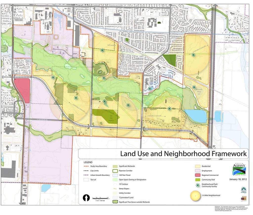
37 Memorandum To: From: Copies: Heather Hansen and Greg Byrne Joe Dills, AICP David Helton, SAAP Project Team Date: February 9, 2012 Subject: South Albany Area Plan Land Use and Transportation Alternatives Project No.: Overview The purpose of this memorandum is to describe the draft Land Use and Transportation System Alternatives for the South Albany Area Plan (SAAP). This memo fulfills Task 4.2 (Draft Project Memorandum #4) of the project scope of work. The graphics referenced in this memorandum are attached as Appendix A. The parts of the memo include: Description of Alternatives Transportation Evaluation Natural Resource Evaluation Archeological Resources Evaluation The key goal for this memorandum is to present basic choices for the direction of the plan. These include fundamental elements such as: land use, street, and trail frameworks; general locations for neighborhood focal points; village centers; preliminary layout of medium and low density residential use; and the types of industrial and commercial uses in the west part of the study area. At this stage of the process (Task 4), the objective is to build consensus for a preferred plan of the above-listed elements. With that established, the project will then address implementation, zoning, and other more detailed aspects of the South Albany Area Plan. Description of Alternatives The following figures comprise the plan set for the Land Use and Transportation System Alternatives (see Appendix A): Land Use and Neighborhood Framework
38 Heather Hansen and Greg Byrne South Albany Area Plan Land Use and Transportation System Alternatives February 9, 2012 Street Framework Concept Trails Framework Concept Concept Alternative 1 Concept Alternative 2 Community Park Alternative Sites Elementary School Alternative Sites Lochner Realignment and Land Use Options Each of the above are discussed below. Land Use and Neighborhood Framework The Land Use and Neighborhood Framework establishes the broad pattern for great neighborhoods, employment growth, and open space in South Albany. With years of residential growth capacity in the study area, the clear identification of this framework is essential to fulfilling the project s vision over the long term. The key components of the Land Use and Transportation Framework are described below. Neighborhoods Residential land use is organized into a series of neighborhoods that are approximately ¼ mile from center to edge (a comfortable 5-10 minute walk). The neighborhoods are intended to implement Albany s Great Neighborhoods principles, policies, and standards, as tailored to South Albany. Walkable neighborhood design, a variety of housing, local parks and open spaces, and community uses are all part of the vision for the neighborhoods shown on the framework plan. Neighborhood Focal Points Neighborhood focal points are identified as Neighborhood Park/Community Facility. The location of these nodes reflects community input that the areas near Oak Creek are important for public and open space uses. The Trails Framework illustrates how these focal points are connected with other areas of the plan. The focal points are conceptually located. They will serve as guidance during future planning, development review, and plan implementation. Regional Commercial and Employment Areas The existing Regional Commercial site (the piano property) is shown as part of the framework. Zoning-related land use and design recommendations will be explored later in the process. The lands currently designated Industrial, and the Urban Reserve site east of the piano property, are designated as employment lands, based on recommendations in the market analysis and support shown by the community in the first public workshop. These job-supporting sites are important to the city as a whole. They also provide local job opportunities that help make South Albany a complete community. 2
39 Heather Hansen and Greg Byrne South Albany Area Plan Land Use and Transportation System Alternatives February 9, 2012 Open Spaces Oak Creek is a central feature of the framework, both geographically and from a community design perspective. It is envisioned as the front door of South Albany integrated with, and accessible to, the community. The framework shows the various types of open space and resources that have been identified in the process: significant wetlands, riparian corridors, 100-year floodplain, Open Space zoning, utility corridors, and the oak groves. There is an extensive pattern of non-significant wetlands that not shown on the land use framework. The spatial pattern of the above-listed open spaces, and how they might be linked together, has been considered in preparing the other plans and alternatives in this memorandum. Community Park The City of Albany owns 27 acres east of Lochner Road for the purpose of a future community park. The park has been slightly reshaped to work with the conceptual street framework. The City has indicated that the park could be relocated two Community Park alternatives are discussed later in this memorandum and shown in Appendix A. Street Framework Concept The Street Framework illustrates how the neighborhoods and employment areas of South Albany can be connected by future streets. The framework includes arterial, collector and connector streets additional local streets will be included but are not shown at the framework level. A transportation evaluation of the plan alternatives, including the Street Framework, is discussed later in this memo and in a separate memorandum prepared by Kittelson and Associates. Key features of the Street Framework include: The arterial and collector streets (Highway 99E, 53 rd -Ellingson Roads, Lochner Road, and Columbus Street are planned per the recommendations in Albany s Transportation System Plan (TSP). Transportation system improvements outside of the study area are also planned per the recommendations of the TSP. All connector streets and intersections on the framework are conceptual and guiding. They are the recommended corridors and point A to point B connections for the plan. They have been drawn to implement the vision and plan objectives for South Albany, linking land use, transportation and open space. Site-specific location and design of these streets will be determined in future planning and development review. The connectors on the Street Framework Concept are assumed to be two lane streets. 3
40 Heather Hansen and Greg Byrne South Albany Area Plan Land Use and Transportation System Alternatives February 9, 2012 Two east-west connectors are provided between Ellingson Road and Oak Creek. These twolane streets provide parallel routes to Ellingson Road and inter-neighborhood connectivity. They connect important designations in each of the neighborhoods: neighborhood focal points, village centers, the community park, Seven Mile Lane, etc. The connector street that parallels Oak Creek on the creek s south side is Oak Creek Parkway. This two lane street connects five neighborhood focal points. It is the southern edge of the Oak Creek Transition Area. Where feasible, it will be an actual physical edge to the flood plain, or other undeveloped parts of the Oak Creek Greenway this is intended as recommended and guiding, not mandatory. The minimum intersection spacing along Lochner Road and Columbus Street is 800 feet. A Lochner Road to Columbus Street connection is made north of Oak Creek, consistent with the TSP. This street is purposefully shown north of the Gerig historic home site this property is an opportunity for a history museum or other use honoring its past. The potential street connection should support, not negatively impact, this site. In the Employment areas south of Ellingson Road, a series of loop connections north of the open space indicates a street pattern supportive of a business park. For the PepsiCo property, the perimeter street pattern is intended as supportive of larger lot industrial uses. Two alternatives for the realignment of Lochner Road are discussed in this memorandum and shown in Appendix A. The minimum intersection spacing along Ellingson Road is a key issue requiring further study, as discussed below. Ellingson Road Intersections Key questions for refining the street framework along Ellingson Road are: Where should full movement intersections be placed, and what should be the design (signals, roundabouts)? Where are right-in/right-out intersections a good solution? Where should access be limited? To answer the above-listed questions, the following issues should be considered: a. Allowing for convenient and safe movements across the corridor in order to effectively link land uses to the north and south. b. The spacing of intersections that will balance distribution of traffic with good east-west mobility. c. Providing safe pedestrian and bike crossings that align with the planned trails and support the walkability goals for the community. d. Planning for a landscaped center median along Ellingson (that includes stormwater and water quality features). 4
41 Heather Hansen and Greg Byrne South Albany Area Plan Land Use and Transportation System Alternatives February 9, 2012 e. How the intersection spacing will influence the 20-year and build-out cross-section, i.e. whether a 3-lane cross-section will work (as opposed to 5 lanes). f. How the intersection spacing will help support retaining all of the neighborhood streets as 2- lane, walkable streets. g. Setting the stage for future transit. h. Limiting access along the grade-separated sections of the 53 rd extension. i. Access to the Business Park. The project team will prepare intersection spacing and design options for review by the Committees. Trails Framework Concept One of the key outcomes of the first community workshop was the strong support for trails in South Albany. The Trails Framework combines this vision with the Land Use and Streets Frameworks to create a network of trails and support the goal of a walkable community. Specific trail elements include: Trail connections between all key destinations and focal points within the study area, forming a network of direct and convenient routes for walking. Trails lead to: neighborhood parks, a future elementary school site, the community park, Oak Creek (six crossings), the Gerig historic property, the oak groves, the village centers, the freeway lakes, Mennonite Village (present and future phases), and employment lands. The trail network provides opportunities for varying loops ranging from a 10 minute stroll within a neighborhood to a 4-mile hike encircling Oak Creek. All trails from the Transportation System Plan (TSP) are included, including the Oak Creek trail. The TSP routes are supplemented by many other trails, both on-street and off-street. Trails are planned within the power line rights-of-way. The trails shown paralleling the railroad rights-of-way are assumed to be: outside of the right-ofway; fenced from the railroad, and buffered from adjacent land uses. The trail connection at Highway 99E near Oak Creek (northwest corner of study area) is an opportunity for an undercrossing at the Oak Creek bridge. Concept Alternatives 1 and 2 Two illustrative plan alternatives (of many possible combinations) have been prepared that show land uses combined with the framework plans described above. The land use elements added are the village centers, medium density residential, low density residential, industrial park (large lot and 5
42 Heather Hansen and Greg Byrne South Albany Area Plan Land Use and Transportation System Alternatives February 9, 2012 business park), light industrial, heavy industrial, regional commercial, and neighborhood commercial. In addition, an overlay called the Oak Creek Transition Area is included. For the purposes of housing and population estimates, each alternative is assumed to have 75 percent of its nonsignificant wetlands mitigated and developed. The two alternatives differ in the distribution of the village centers, and the design of medium density residential uses and civic uses near the centers. This transect of land use is intended to activate the centers, organize the housing choices, meet housing needs identified in the market study, and support future transit. The alternatives show broad patterns of land use integrated with transportation. In the next task of the project, implementing regulations and guidelines will be prepared. These may include changes to existing zoning, cluster development options, planned developments, etc. Residential Low Density This designation provides a variety of low density detached and attached (duplexes) housing types at approximately five dwellings per acre. Approximately 65 percent of dwelling units would be low density, occupying approximately 78 percent of buildable residential land. Example uses: single family homes, cottage homes, duplexes Residential Medium Density This designation provides a variety of detached and attached housing types. The maximum density for apartments would be set at 20 dwelling units per acre, per the market analysis. The average density across all housing types would be 12.7 dwelling units per acre. Approximately 35 percent of dwelling units would be medium density, occupying approximately 22 percent of buildable residential land. Example uses: cottage homes, tri-plexes, townhomes, apartments, condominiums, live-work units Village Center This designation would implement, in part, the village center designation in the Comprehensive Plan. The village center areas on the alternatives are intended for neighborhood serving retail, personal services, and community uses. The village centers comprise a total of 10 acres. Example uses: grocery store, coffee shop, day care, civic center, library The village center locations shown on the alternatives are based on input received at the first public workshop. There were many suggested locations, with an overall theme of providing multiple small centers serving the neighborhoods in South Albany. Alternative 1 has a 5-acre center located at the intersection of Lochner and Ellingson Road. Two 2- acre centers are provided on Ellingson Road and the west side of Lochner Road. A one-acre center is provided at Mennonite Village. 6
43 Heather Hansen and Greg Byrne South Albany Area Plan Land Use and Transportation System Alternatives February 9, 2012 Alternative 2 has two centers, approximately 4 acres each, located along the 53 rd extension and Columbus Street (west and east sides). Two smaller centers, at approximately 1-acre each, are located on Lochner Road and at Mennonite Village. Neighborhood Commercial Properties currently zoned neighborhood commercial along Highway 99E are shown as neighborhood commercial on the alternatives. Example uses: retail serving nearby businesses, Linn-Benton Community College, and neighborhoods west of Highway 99E Regional Commercial The 36-acre piano property is currently zoned Regional Commercial and shown as such on the alternatives. Example uses: large format retail, regional shopping center, residential above or attached to a business For this memorandum, the uses and development standards of RC site are not addressed. They will be discussed in Task 6 of the project. Industrial Uses Industrial-Large Lot This designation reflects the market analysis recommendation to provide large lot sites for industrial uses. The concept is to retain the same or similar zoning as the current Industrial Park designation. While large lot industrial is a need, it is assumed flexibility would be retained to locate a range of employment uses in this area. Example uses: manufacturing, regional warehousing Industrial-Business Park This designation is consistent with the market analysis findings for light industrial uses and medium sized sites in the area. Located south of the 53 rd Extension, the site is a logical addition to the employment-oriented land on the west side of the study area. The business park would be a more compatible neighbor to the adjacent neighborhoods than other industrial uses. Development would have more of a campus setting than other industrial areas. It should be designed to create flexibility for parcels to be combined or divided to accommodate a diversity of users. Example uses: assembly and light manufacturing within enclosed buildings, flex space, offices Industrial-Light and Heavy The pattern of Light Industrial and Heavy Industrial zoning has been included on the alternatives. Example uses: manufacturing 7
44 Heather Hansen and Greg Byrne South Albany Area Plan Land Use and Transportation System Alternatives February 9, 2012 Compatibility Measures The following are initial ideas for promoting compatibility between the industrial properties and adjacent areas: a. Continue the City s current development review practices for conditional uses and review for environmental performance for some industrial uses. b. Establish design guidelines for the east edge of the Industrial-Business Park site so it has appropriate landscaping, signage, building design, and other features. c. To the extent possible, locate mitigation sites and stormwater features in the areas between industrial use and other uses to create a green buffer. d. Increase setbacks when adjacent to residential uses. e. Promote good neighbor agreements that are based on dialogue between area businesses and their neighborhoods. This is a non-regulatory approach intended to identify compatibility ideas based on a working relationship between industry and the community. Community Park The City-owned community park site is included on the plan. Per the Albany Park and Recreation Masterplan, this site is planned to provide space for other facilities (soccer/football fields, skate park) and to make certain facilities (picnic pavilion, community scale play area) more geographically accessible to residents living in this part of the City. Example uses: sports fields, skatepark Oak Creek Transition Area An Oak Creek Transition Area is shown on Concept Alternatives 1 and 2. Several key findings from Tasks 1-3 support this recommendation. They are: The vision statement cites Oak Creek as the front yard of the community. An Oak Creek Greenway is identified in the plan objectives. The Greenway is intended as integrating public and private open space, providing multiple benefits, being physically and visually accessible, having a multitude of public connections at its edge, including continuous east-west pathways, and connecting north-south pathways. The edge of buildable land versus unbuildable land is not a hard edge that can be mapped with certainty. It will be highly influenced by future wetland delineations, and state and federal decisions regarding permitting of wetland modifications and mitigation. On the ground, the process of site specific design and permitting with resultant establishment of the Oak Creek Greenway edge will occur over many, many years. 8
45 Heather Hansen and Greg Byrne South Albany Area Plan Land Use and Transportation System Alternatives February 9, 2012 There are challenges to integrated planning, such as (a) protecting natural resources versus economic use of property, (b) the reality of multiple property ownership spread over a large area, and, (c) both private companies and public agencies may have plans and policies that potentially conflict with the SAAP. Given the above, the alternatives seek to create a balance of: (1) certainty for the vision for Oak Creek; and, (2) flexibility to address unknowns and long term implementation. The Oak Creek Transition Area is the proposed concept and tool to strike that balance. The Transition Area includes approximately 63 acres of land outside of constrained lands (e.g. Open Space zoning, significant wetlands). The following describes the proposed Oak Creek Transition Area. a. Purpose - The purpose of the Oak Creek Transition Area is to guide development review and more detailed planning for the transitional edge of the Oak Creek Greenway. The Greenway is intended to integrate open space areas, both public and private, near Oak Creek. Per the Plan Objectives, the Greenway will: Be the centerpiece of the South Albany open space system, providing multiple benefits: wetland protection and mitigation, habitat, flood storage, pathways, recreation, archaeological and historic resources, environmental education, and visual identity for the area; Be South Albany s front yard - physically and visually accessible to adjacent development; Include Oak Creek Parkway (an east-west street), and other public uses Include a continuous east-west pathway, and other pathways that connect north and south to community destinations; and Have a multitude of public connection (parks, trails, trailheads, visual, etc.) between Oak Creek Parkway (an east-west street) and the public edge of the Greenway. b. Preferred Uses - The Transition Area is the preferred location for neighborhood parks, community facilities, the elementary school, wetland mitigation areas, storm-water facilities, community gardens, and other community-oriented and open space uses. c. Uses in Base Zone Permitted - The preferred uses listed above are guiding, not binding. In addition to the preferred uses, the transition area may be developed for uses permitted by the base zoning, where development is allowed by the comprehensive plan, development code, and state/federal permitting. All development would be required to meet the City s standards and design guidelines. 9
46 Heather Hansen and Greg Byrne South Albany Area Plan Land Use and Transportation System Alternatives February 9, 2012 d. Design Review - All development in the transition area would undergo design review. A new Transition Area Overlay or similar tool would be created. Design review would ensure that the purposes of the Greenway are met by proposed development. The standards and guidelines would ensure that development does not wall off Oak Creek. Industrial and other non-neighborhood areas will be addressed on a case-by-case basis, with standards and guidelines tailored to their needs. e. Oak Creek Parkway - The east-west connector street south of Oak Creek is Oak Creek Parkway. The alignment shown is conceptual the specific alignment will be established in future planning or development review. It is preferred, but not mandatory, that the Parkway be located at the interface of the developed area and open area. This will place residential and other neighborhood uses to the south of the Parkway and the preferred open space and community uses listed above to the north. f. Oak Creek Trail - A continuous east-west pathway is planned to parallel Oak Creek within the transition area. Other trails will be also be provided per the Trails Framework Concept. g. Historic and Archeological Resources - Historic resources, such as the Gerig home site, are included in the transition area to assist with their preservation as an honored part of the area s heritage and integrated part of its future. The Transition Area also encompasses much of the area with potential for archeological resources. In addition to the design review recommended above, Annexation Agreements may also be a tool to help achieve the vision for Oak Creek. Annexation agreements are a tool used by the City to ensure that the proposed annexation is in the public interest. The terms of annexation agreements may include, but are not limited to, dedication of land for future public facilities, construction of public improvements, waiver of compensation claims, or other commitments and public benefits deemed valuable to the City of Albany. The agreement is recorded as a covenant running with the land. The key to long term success for the Oak Creek vision is that it does not rely solely on regulation. There should be a combined, collaborative effort of public investments, land owner initiatives, pilot projects, wetland banking/coordinated permitting, and community involvement that collectively help implement the plan. Community Park - Alternative Sites Two sites for a future community park are shown on the plan titled Community Park Alternative Sites. Site 1 is the city s existing 27-acre site east of Lochner Road. This property has several assets: it is in public ownership, flat, and has good access from Lochner Road. Adjacent lands are currently undeveloped, but would eventually be residential and a village center. At 27 acres, Site 1 is a relatively large individual use within its neighborhood. It would provide a signature open space, but would also disrupt the continuity of the street and block pattern within the neighborhood. 10
47 Heather Hansen and Greg Byrne South Albany Area Plan Land Use and Transportation System Alternatives February 9, 2012 Site 2 is located north of Oak Creek along Lochner Road. This property is also flat and has good access from Lochner Road. It is privately owned (Irwin Gehrig). Adjacent uses are residential (east), vacant (north, the GAPS property), and industrial/youth correction center (west). The presence of the historic Gerig home site creates a unique opportunity to combine the community park with the historic site. A history museum or living farm could be located adjacent to the park, expanding its attraction and perceived acreage. The utility corridor at the north end of Site 2 provides a trail connection over to Columbus Street. Elementary School Alternative Sites An elementary school is part of the future land uses anticipated for South Albany. One elementary is potentially needed within the 20-year time, and a second may be needed for growth beyond the 20-year timeframe. Eight potential alternative sites have been identified and mapped on the plan titled Elementary School Alternative Sites. Sites 4, 6, and 7 provide the best implementation of the Oak Creek Transition Area concept and are therefore labeled as recommended. Good access to the transportation system and adjacent neighborhoods are important considerations for the school site. Lochner Road Realignment Alternatives The potential for a realignment of Lochner Road and its connection to Marion Street was identified by the City. The plan titled Lochner Realignment and Land Use Options shows how land uses might be organized around this realignment. The realignment would support expansion of industrial land use with rail access to the east of the Sno-Temp property and substantially reduce the cost of arterial street and infrastructure improvements needed to serve the area.. Transportation Evaluation - Summary A transportation evaluation for the alternatives has been prepared by Kittelson and Associates please see memorandum dated January 25, The following is a summary of the conclusions from the memorandum, with comments from City staff incorporated. There are several recommended transportation facilities and improvements for the study area based on the two concept alternatives, described below. The plans for the extension of 53 rd Avenue and Ellingson Road include a three-lane cross section. There is a potential need for a future five-lane cross-section, but this needs further analysis in the next phase of the SAAP. Full build-out of the study area may make a five-lane cross section necessary; however three-lanes are anticipated to be adequate for the 20 year horizon depending on how development concentrates around the study area. The traffic volumes assumed in the TSP reflect approximately one-third of the full development potential of the study area. Full build-out will likely require additional roadways, such as Columbus Street and the Ellingson Road Extension, to also need five-lanes. This will be further analyzed in the next phase of the project. 11
48 Heather Hansen and Greg Byrne South Albany Area Plan Land Use and Transportation System Alternatives February 9, 2012 Relocating the Lochner Road-Marion Street connection to just south of the large industrial parcels should be considered. It has the potential to eliminate an existing railroad crossing of the spur line, allow for additional spur access to the undeveloped industrial property on Lochner Road, provide a more cost effective way to improve the Lochner-to-Marion Street connection, and reduce the infrastructure costs needed for development. The proposed concept alternatives will both add significant traffic to the intersections in the study area, which could require intersection treatments, particularly at the un-signalized intersections. Roundabouts should be the first intersection design considered at several intersections, particularly at the Columbus Street/Ellingson Road and Lochner Road/Ellingson Road intersections. In addition to the safety and capacity benefits that roundabouts often have over traffic signals, roundabouts would provide the area with better bicycle and pedestrian connections between land uses on opposite sides of corridors. Roundabout also have the advantage of being able to be installed during the early stages of development in an area, while construction of traffic signals generally need to be delayed until development in the area is dense enough for traffic volumes to meet MUTCD signal warrants. Single-lane or multi-lane roundabouts may be able to serve the traffic volumes at these intersections and provide operational and safety benefits. Single-lane roundabouts can service up to 25,000 vehicles per day, while multi-lane roundabouts can typically service up to 45,000 vehicles per day. The next phase of the project will provide more details on the specific intersections needs for 2030 and for build-out of the area. A series of trails have been proposed for the study area, illustrated in the Trails Framework Concept. These trails serve to connect residential areas to neighborhood parks and community facilities. They also provide connections to bike lanes and sidewalks proposed in the TSP for the 53 rd Extension, Ellingson Road, Columbus Street, and Lochner Road. These trails, bike lanes, and sidewalks will significantly enhance pedestrian and bicycle connectivity. Additional bicycle treatments, such as bicycle boulevards, bicycle signals or intersection treatments could also be considered. Transit service could be extended to the study area, which is currently only served by routes along 99E. The study area will be transit supportive at build-out; however, if development occurs in an unconcentrated manor over the next 20 years, it may not be transit supportive by If development is concentrated around one or two village centers, transit supportive areas are possible by Service currently runs along Columbus Street to Del Rio Avenue. This service could be continued further down Columbus Street to Ellingson Road to serve residential areas and village centers in these areas. The concept alternatives concentrate residential developing along the 53 rd Avenue Extension and Ellingson Road, making this also a likely route for transit. A bus route along Ellingson Road and 53 rd Avenue could connect to any of the three routes currently running along 99E. Transit stops along the Ellingson Road and 53 rd Avenue corridor should be designed with turn outs to avoid impacting the capacity of the corridor. 12
49 Heather Hansen and Greg Byrne South Albany Area Plan Land Use and Transportation System Alternatives February 9, 2012 Natural Resource Evaluation - Summary A natural resource evaluation for the alternatives has been prepared by Mason, Bruce and Girard please see memorandum dated January 19, The following is a summary of the conclusions from the memorandum, with comments from City staff incorporated. In order to minimize impacts to sensitive natural resources while also meeting the land use and transportation goals of the City of Albany, the SAAP alternatives have taken into consideration the locations of significant wetlands, Oak tree groves and the Oak Creek riparian corridor. The SAAP provides a strategic, collaborative approach to land use planning by locating community centers, schools, neighborhoods and principal roadways and trails outside of sensitive natural resources to the degree practical. This is a good approach to integrating environmental and development objectives. Without it, the area would likely experience a small, piece meal development approach that typically results in larger impacts to sensitive resources. The SAAP recognizes that the Oak Creek corridor is significant natural resource and a focal point for recreation and community sustainability for the residents of the area. The SAAP has identified a trail network that incorporates trails that parallel much of the length of the corridor to provide recreational opportunities and direct access to the corridor for residents. To the greatest extent practical, proposed trail alignments have been located outside of wetlands with the goal of preserving the continuity of these sensitive areas within the study area. The SAAP also identifies several trail and road crossings of the Oak Creek corridor. Where possible, the locations of crossings have been selected to take advantage of the narrowest points of the corridor and to provide important connections between community centers. Future planning of new crossings should be conducted to maintain the integrity of the riparian area by minimizing the number of future crossings and selecting crossing locations at the narrowest points of the corridor. When crossings are necessary, utilizing perpendicular road/trail alignments, retaining walls to minimize fill, boardwalks for trails, and full-span bridges over stream crossings will minimize habitat disturbances and impacts to the fluvial dynamics of Oak Creek. Stormwater management should also be incorporated as development of the transportation system and residential areas is expanded so that water quality and quantity conditions in Oak Creek and its tributaries can be maintained or improved. Other resource-related planning efforts by the City will affect how development occurs in South Albany, such as (a) the regional general permit for wetland mitigation of for the PepsiCo property (part of a regional efforts coordinated by the Council of Governments), and (b) the new water quality regulations that will be adopted as part of the NPDES (National Pollutant Discharge Elimination System) Phase 2 process. The new standards related to water quality and NPDES will be developed over the next year. The SAAP alternatives also take into consideration the locations of significant wetlands for the colocation of schools, trails, community centers, and roadways. Many of the wetlands immediately adjacent to the Oak Creek corridor will be maintained and all of the wetlands designated significant by the City will be protected except for those impacts allowed through Goal 5 ESEE review. 13
50 Heather Hansen and Greg Byrne South Albany Area Plan Land Use and Transportation System Alternatives February 9, 2012 The Oak Creek corridor, existing significant wetlands, and other wetlands that currently function as agricultural land provide significant opportunities for on-site wetland mitigation through restoration or enhancement of existing wetlands or direct wetland creation. The study area is also located within the service area for several wetland mitigation banks that can provide additional mitigation for those elements of the SAAP that impact wetlands. In addition, the SAAP does take into account the need for an additional setback or buffer from the Oak Creek corridor by focusing the majority of future land development actions away from Oak Creek. Potential Oak Creek buffer/setbacks should be maintained during future planning in order to facilitate development and planning of natural transitional areas between the Oak Creek corridor and proposed developments. The proposed Oak Creek Greenway will also serve as an important transitional area between proposed developments and Oak Creek. The Greenway has the potential to preserve open space areas and provide recreational opportunities while also providing protection to wetlands and the Oak Creek riparian area. In addition to the Greenway, existing breaks in topography (e.g., old stream banks or channels) and distinct abrupt changes in vegetation (e.g., forested edges along agricultural fields) should be utilized to define additional transitional areas between habitats where possible to increase the organic aesthetic nature of the area. If feasible, existing wetland and waterway location data (LWI, City of Albany, 1999) should be updated or modified to clearly reflect the contemporary conditions within the study area. A compilation of existing jurisdictional wetland/waters delineations would allow for a better estimate of potential impacts within the study area. Furthermore, additional delineations will be required on an individual site basis as land uses are proposed and developed throughout the study area. The significant oak tree groves within the study area may be small and discontinuous in comparison to the continuous forested vegetation of the Oak Creek corridor; nonetheless, they may provide a specialized niche for sensitive species. Existing significant oak tree groves outside the Oak Creek corridor should be considered for protection through incentives built into the development review process. Botanical surveys are also recommended within the limits of any proposed development alternatives associated with the SAAP. These surveys will need to be conducted during the appropriate flowering window for the sensitive species discussed above to confirm their presence or absence. Prior to initiating any development alternatives associated with the SAAP that may impact sections of Oak Creek, it is recommended that additional fish and amphibian surveys be conducted to determine detailed fish and amphibian distribution within the study area. The following are suggested conservation measures to reduce impacts to sensitive wildlife, plant, and fish species. It is not assumed these would be regulations. They are intended as ideas to be considered in the implementation of the plan. Clearly identify sensitive wildlife, plant, and fish habitats in the field prior to development. Improve degraded wildlife habitat or abandoned agricultural areas within the proposed project areas with new plantings of native species. Introduce native shrub and tree species that provide cover and food sources for wildlife during landscaping. Mitigation plantings would include a diverse assemblage of species native to the proposed project areas. 14
51 Heather Hansen and Greg Byrne South Albany Area Plan Land Use and Transportation System Alternatives February 9, 2012 Monitor all new mitigation and restoration areas until they meet compliance criteria established by applicable environmental permits. Incorporate noxious weed removal and management into any future proposed actions. Restrict tree removal activities to between September 30 and March 1 to avoid conflicts with nesting migratory birds in compliance with the Migratory Bird Treaty Act (MBTA). Archeological Evaluation One of the objectives of project design is to avoid impacts to archaeological resources and historic sites to the fullest extent feasible. Although only a portion of the study area had been previously surveyed for archaeological resources, the results of those studies were used to identify a zone of archaeological potential that overlaps to a great extent with wetlands and with the Oak Creek Transition Area. While the concept design succeeds in minimizing impacts from residential development and village centers, even the creation or modification of recreation areas, wetland mitigation areas, and other recreational and habitat enhancements can result in the disturbance or destruction of an archaeological site through earth-moving activities. For example, a majority of the neighborhood park facilities are situated in the zone of archaeological potential in the Oak Creek-wetland transition area in order to take advantage of the recreational opportunities afforded by the open spaces of the wetlands. If archaeological sites can be identified through field survey early in the planning process, they can likely be avoided and protected to a great extent through design adjustments. Overall, more than one-third of the proposed planning area has been previously surveyed for cultural resources, which will enable avoidance measures to be implemented on those parcels. It is recommended that the remainder of the project be surveyed for archaeological resources in concert with the early stages of design. An archaeological management plan should be developed to outline efficient means of surveying area parcels and for identifying specific options for the treatment of identified archaeological sites. In addition to archaeological sites, three potentially significant historic properties were identified in the project area: (1) 6732 Seven Mile Way, (2) 6061 Columbia Street, and (3) 3795 Lochner Road. These three properties have been identified from a records review, and have not been investigated to verify the age, condition, or significance of structures on the properties, but these sites are potentially important as they all date to the nineteenth century. In particular, the assessor s database identifies the year built for 3795 Lochner Road as 1860 which would make it of particular significance. Properties from the 1800s are becoming increasingly rare in Oregon as structures become more fragile through weathering and difficulties with maintenance. For those historic structures that can survive and even be rehabilitated, they can become anchor points for historic parks--such as the Dorris Ranch Living History Filbert Farm in Lane County--providing broadreaching opportunities to the community for education, recreation, and historic interpretation. 15
52 Heather Hansen and Greg Byrne South Albany Area Plan Land Use and Transportation System Alternatives February 9, 2012 This page intentionally left blank. 16
53 Heather Hansen and Greg Byrne South Albany Area Plan Land Use and Transportation System Alternatives February 9, 2012 Appendix A Land Use and Transportation Alternatives Plan Set 17
54 Heather Hansen and Greg Byrne South Albany Area Plan Land Use and Transportation System Alternatives February 9, 2012 This page intentionally left blank. 18
55 19

56 20
57 21
58 22

59 23
60 24
61 25

62 Lochner Realignment and Land Use Options 26
COLVER ROAD INDUSTRIAL CONCEPT PLAN
 COLVER ROAD INDUSTRIAL CONCEPT PLAN A CONCEPTUAL LAND USE AND TRANSPORTATION PLAN FOR TA-4 AN URBAN RESERVE AREA OF THE CITY TALENT City of Talent Adopted by City Council Resolution No., June, 2015 PART
Gold Line Bus Rapid Transit Transit Oriented Development (BRTOD) Helmo Station Area Plan
 Helmo Station Area Plan") Appendix F Gold Line Bus Rapid Transit Transit Oriented Development (BRTOD) Helmo Station Area Plan Introduction and Purpose of the Plan The Gold Line Bus Rapid Transit facility is an eleven-mile dedicated
Appendix F Gold Line Bus Rapid Transit Transit Oriented Development (BRTOD) Helmo Station Area Plan Introduction and Purpose of the Plan The Gold Line Bus Rapid Transit facility is an eleven-mile dedicated
Ten Mile Creek Planning Area
 PLANNING AREA POLICIES TEN MILE CREEK Ten Mile Creek Planning Area Location and Context The Ten Mile Creek Planning Area ( Ten Mile Creek area ) is located south of the current Boise AOCI, generally south
ARTICLE 6: Special and Planned Development Districts
 ARTICLE 6: Special and Planned Development Districts 6-10 Traditional Neighborhood Development (TND) District 6-10.10 Purpose and Intent The Traditional Neighborhood Development (TND) District provides
The transportation system in a community is an
 7 TRANSPORTATION The transportation system in a community is an important factor contributing to the quality of life of the residents. Without a sound transportation system to bring both goods and patrons
Woodburn Comprehensive Plan Growth Management Goals and Policies
 Goal Woodburn Comprehensive Plan Growth Management Goals and Policies G-1. The City's goal is to manage growth in a balanced, orderly and efficient manner, consistent with the City s coordinated population
open public hearing and allow public comment request to continue LPA public hearing to January 16, 2014 at 10:30 am
 TODAY S AGENDA Work Session LPA Transmittal Public Hearing open public hearing and allow public comment request to continue LPA public hearing to January 16, 2014 at 10:30 am staff will issue a recommendation
Secrest Short Cut and Monroe Expressway Small Area Plan AUGUST 29, 2018
 Secrest Short Cut and Monroe Expressway Small Area Plan AUGUST 29, 2018 Background and Process Monroe Expressway will be open by the end of 2018 Union County and Indian Trail identified a need to revisit
DRAFT PLAN PRESENTATION
 DRAFT PLAN PRESENTATION 1.23.2018 AGENDA Process Project Schedule Results from Visioning Workshop Draft Plan Highlights Concept Plans Feedback Next Steps PROJECT SCHEDULE KICK-OFF WORKSHOP August 29 th
LAND USE OVERVIEW WHAT YOU WILL FIND IN THIS CHAPTER
 LAND USE WHAT YOU WILL FIND IN THIS CHAPTER Information about the City s expected population and employment growth. Description and capacity of existing and future land use designations. Policies that
Westbound: A One-day Exploration of Growth
 Westbound: A One-day Exploration of Growth Frog Pond Area 2018 UGB Expansion Proposal June 13, 2018 Growing Out: UGB Asks Four cities submitted proposals to expand greater Portland s urban footprint by
Additional information about land use types is given in Chapter 5. Design guidelines for Centers and Neighborhoods are given in Chapter 7.
 4. Place Types Introduction In Albemarle County s Development Areas, the Neighborhood is the fundamental unit of community planning. The County s Neighborhood Model, an adopted part of the Comprehensive
Newcourt Masterplan. November Exeter Local Development Framework
 Newcourt Masterplan November 2010 Exeter Local Development Framework Background The Exeter Core Strategy Proposed Submission sets out the vision, objectives and strategy for the development of Exeter up
Applicant Name Phone / Fax / Address City State Zip Code . Property Owner Phone / Fax / Address City State Zip Code
 Master Development Plan Application Community Development Department City of Redmond 411 SW 9 th Street Redmond, Oregon 97756 541-923-7721 541-548-0706 FAX Master Development Plan Fee $38,862.52 File Number
Dwelling Units Max 12 dwelling units per acre/min 8 dwelling units per acre. Development Mix 80% non residential/20% residential
 13. OSTEEN LOCAL PLAN Background: The Osteen Local Plan area is located in southwest Volusia County along the SR 415 corridor between Lemon Bluff Road and Acorn Lake Road and includes 3,990 acres. The
V. Vision and Guiding Principles
 V. Vision and Guiding Principles The Master Plan for the Powers Ferry Corridor seeks a foundation in the desires of the community. At times, various elements of the community offered opposing viewpoints,
CHAPTER 7: VISION AND ACTION STATEMENTS. Noble 2025 Vision Statement
 CHAPTER 7: VISION AND ACTION STATEMENTS This chapter presents the vision, policy and action statements that transform the comprehensive planning study, an analysis of Noble s past, future trends and community
Location. Need GOAL 14 URBAN GROWTH BOUNDARY. Urban Planning in Oregon 7/8/2015
 Urban Planning in Oregon June 24, 2015 Redmond, Oregon Gordon Howard, DLCD Urban Planning Specialist GOAL 14 URBAN GROWTH BOUNDARY To provide for an orderly and efficient transition from rural to urban
Scope of Services. River Oaks Boulevard (SH 183) Corridor Master Plan
 Corridor Master Plan") Scope of Services River Oaks Boulevard (SH 183) Corridor Master Plan PROJECT AREA The project area consists of the River Oaks Boulevard (SH 183) corridor bounded by SH 199 at the northern end and the Trinity
Scope of Services River Oaks Boulevard (SH 183) Corridor Master Plan PROJECT AREA The project area consists of the River Oaks Boulevard (SH 183) corridor bounded by SH 199 at the northern end and the Trinity
Mitchell Ranch South MPUD Application for Master Planned Unit Development Approval Project Narrative. Introduction
 Mitchell Ranch South MPUD Application for Master Planned Unit Development Approval Project Narrative Introduction Mitchell Ranch South is a proposed single family (detached) residential development on
Cobb County Design Guidelines Mableton Parkway & Veterans Memorial Highway Community Design Workshop January 12, 2017
 Community Design Workshop January 12, 2017 Agenda Opening Remarks / Introductions Scope of Work Existing Conditions Key Issues / Opportunities VPS Summary Draft Vision & Goal Statement Implementation Concepts
IMPLEMENTATION STRATEGIES. In This Chapter. Goals & Strategies 182 Project List 183 Future Land Use 186 CHAPTER 11 IMPLEMENTATION STRATEGIES
 In This Chapter Goals & Strategies 182 Project List 183 Future Land Use 186 11 IMPLEMENTATION STRATEGIES NORTH AUGUSTA, SC 2017 COMPREHENSIVE PLAN 179 Individual commitment to a group effort that is what
REVIEW AND EVALUATION OF REGIONAL LAND USE
 REVIEW AND EVALUATION OF REGIONAL LAND USE AND TRANSPORTATION SCENARIOS #220831 Environmental Justice Task Force October 7, 2014 VISION 2050 Process Development of Guiding Vision for Land Use and Transportation
Comprehensive Plan. Faribault, Minnesota. Hoisington Koegler Group Inc. Claybaugh Preservation Architecture Inc. Howard R. Green Company Bonz/REA
 Comprehensive Plan Faribault, Minnesota Adopted by the Faribault City Council July 8, 2003 prepared for: prepared by: Hoisington Koegler Group Inc. Claybaugh Preservation Architecture Inc. Howard R. Green
Chapter 1.0 Introduction
 Chapter 1.0 Introduction 1.1 Background The North Metro commuter rail line is part of the RTD FasTracks regional transit system expansion program to build more than 100 miles of rail transit throughout
SECTION II SECTION II STATEMENT OF GOALS, OBJECTIVES, PRINCIPLES, ASSUMPTIONS, POLICIES AND STANDARDS
 STATEMENT OF GOALS, OBJECTIVES, PRINCIPLES, ASSUMPTIONS, POLICIES AND STANDARDS 1 2 STATEMENT OF GOALS, OBJECTIVES, PRINCIPLES, ASSUMPTIONS, POLICIES AND STANDARDS INTRODUCTION The New Jersey Municipal
Staff Report and Recommendation
 Community Planning and Development Planning Services 201 W. Colfax Ave., Dept. 205 Denver, CO 80202 p: 720.865.2915 f: 720.865.3052 www.denvergov.org/cpd TO: City Council Neighborhoods and Planning Committee
Section 4 BUILDING THE MASTER PLAN
 The Master Plan 33 Section 4 BUILDING THE MASTER PLAN Figure 4:1. A collaborative effort characterized the two design workshops sponsored by DISC to create hypothetical Master Plans for the Towers Property
Site Plan Review Residential Accessory Building
 COMMUNITY DEVELOPMENT DEPARTMENT Planning Division P.O. Box 490 333 Broadalbin Street SW Albany, OR 97321 Phone (541) 917-7550 Fax (541) 917-7598 www.cityofalbany.net Site Plan Review Residential Accessory
Complete Neighbourhood Guidelines Review Tool
 Complete Neighbourhood Guidelines Review Tool Prepared By: City of Regina Planning Department October 2014 Page 1 of 14 Community Development Review Checklist for Secondary Plans and Concept Plans The
Brampton. Secondary Plan. Review. Bram West. A New Direction in Planning & Public Consultation
 Brampton Bram West Secondary Plan Review A New Direction in Planning & Public Consultation Introduction The Bram West Secondary Plan Review offers an important opportunity for the community to define a
Draft Memorandum #1: Goals and Vision for Revitalization
 Keizer Revitalization Plan Draft Memorandum #1: Goals and Vision for Revitalization Submitted to: City of Keizer April 12, 2018 (revised) Prepared By: Angelo Planning Group and Otak, Inc. Project No. 17482.A
Executive Summary. NY 7 / NY 2 Corridor
 Executive Summary NY 7 / NY 2 Corridor Transportation and Land Use Study December 2005 Prepared for: Town of Colonie Capital District Transportation Committee Prepared by: Introduction: Land use decisions
SPECIFIC PLAN Requirements
 CITY OF LANCASTER PLANNING DEPARTMENT 44933 Fern Avenue, Lancaster, California 93534 (661) 723-6100 SPECIFIC PLAN Requirements Purpose The purpose of a specific plan is to provide for the logical development
Major Subdivision Sketch Plan Checklist
 This checklist provides specific requirements that are apart of the Sketch process. The entire process is described by the Huntersville Subdivision Review Process which details all the submittal and resubmittal
PART 1: PROJECT SUMMARY. The application is Attachment A. The site plan is Attachment B.
 Belleterre Subdivision Sketch Plan Town Board 8.7.17 Belleterre Subdivision Sketch Plan PART 1: PROJECT SUMMARY Applicant: Bowman Development Project Size: +/- 20.85 acres Parcel Number: 01115104 and 01115121
Lehigh Acres Land Development Regulations Community Planning Project
 Lehigh Acres Land Development Regulations Planning Effort Summary In July, 2010 Commissioner Frank Mann invited the Lehigh Acres community to start discussing how to achieve their recently adopted community
PROJECT BACKGROUND. Preliminary Design Scope and Tasks
 PROJECT BACKGROUND Preliminary Design Scope and Tasks The purpose of this Study is the development of preliminary designs for intersection improvements for Trunk Highway (TH) 36 at the intersections of
Definitions. Average Daily Traffic Demand (ADT): The actual number or projected number of cars that pass a point in a 24-hour period.
: The actual number or projected number of cars that pass a point in a 24-hour period.") Definitions Access Management: A combination of physical techniques and transportation policies used to control the flow of traffic between roads and the surrounding lands. Alternative City Form Scenarios:
Definitions Access Management: A combination of physical techniques and transportation policies used to control the flow of traffic between roads and the surrounding lands. Alternative City Form Scenarios:
Subject: City of Richfield Cedar Avenue Corridor Plan Comprehensive Plan Amendment, Review File No
 Committee Report Business Item No. 2017-21 Community Development Committee For the Metropolitan Council meeting of January 25, 2017 Subject: City of Richfield Cedar Avenue Corridor Plan Comprehensive Plan
Official Plan Review
 Official Plan Review Summary Report - The Built Environment August 2014 Part 1: Introduction Planning for a healthy, prosperous and sustainable community is an important goal for our municipality. From
CITY OF CHARLOTTESVILLE, VIRGINIA CITY COUNCIL AGENDA
 CITY OF CHARLOTTESVILLE, VIRGINIA CITY COUNCIL AGENDA Agenda Date: December 16, 2013 Action Required: Adoption of Resolution Presenter: Staff Contacts: Title: James E. Tolbert, AICP, Director of NDS James
NORTH CLAYMONT AREA MASTER PLAN COMMUNITY WORKSHOP #1 FEBRUARY 3, 2016
 NORTH CLAYMONT AREA MASTER PLAN COMMUNITY WORKSHOP #1 FEBRUARY 3, 2016 1. Introduction To the team and to the Plan Planning Partners The Claymont Community WILMAPCO New Castle County Claymont Renaissance
City of Farmington. Downtown Plan. Amendment to the 1998 Master Plan Adopted October 11, 2004
 City of Farmington Amendment to the 1998 Master Plan Adopted October 11, 2004 Introduction Planning Background 1 Scope and Components of the Plan Amendment 2 Concept Introduction 3 Plan Concepts 3 Conceptual
PREPARED FOR: PLATTEVIEW ROAD CORRIDOR STUDY EXECUTIVE SUMMARY
 PREPARED FOR: PLATTEVIEW ROAD CORRIDOR STUDY EXECUTIVE SUMMARY SEPTEMBER 2016 Introduction The Platteview Road Corridor Study was led by the Metropolitan Area Planning Agency (MAPA) with assistance from
1.0 Purpose of a Secondary Plan for the Masonville Transit Village
 Report to Planning and Environment Committee To: Chair and Members Planning & Environment Committee From: John M. Fleming Managing Director, Planning and City Planner Subject: Masonville Transit Village
CITY OF TIGARD EXPECTED SERVICE AREA
 CITY OF TIGARD EXPECTED SERVICE AREA City overview / Background Incorporated in 1961, the has experienced rapid growth over the years. This growth can be attributed to many factors, primarily the close
Natomas Vision Plan and PLNP
 Natomas Vision Plan 20030171 and PLNP2014-00172 Department of Community Development Planning and Environmental Review Leighann Moffitt Sub-Agenda 1. Staff Presentation Leighann Moffitt, County Planning
Background Summary Report
 Background Summary Report May 2014 Submitted by Macaulay Shiomi Howson Ltd. In association with AMEC MMM Group Brook McIlroy Inc. Hemson Consulting Ltd. Table of Contents 1. Introduction... 1 2. Why is
SOUTH NATOMAS COMMUNITY PLAN
 SOUTH NATOMAS Community Plan Part Three : COMMUNITY PLAN AREAS AND SPECIAL STUDY AREAS SACRAMENTO 2030 GENERAL PLAN Contents Community Location... 3-SN-3 Community Vision... 3-SN-4 Community Profile...
Review of Opportunity Area C Draft Comprehensive Plan and Draft BOS Follow-On Motions. Special Working Group Meeting March 4, 2015
 Review of Opportunity Area C Draft Comprehensive Plan and Draft BOS Follow-On Motions Special Working Group Meeting March 4, 2015 The slides that follow identify where the draft Comprehensive Plan has
CHAPTER 2 SUMMARY 1. PROJECT SUMMARY DATA
 CHAPTER 2 SUMMARY This is an Initial Study format used to determine, pursuant to CEQA Guidelines Section 15177, whether a project 1) is within the scope of a Master EIR (MEIR), 2) may result in additional
Town of Peru Comprehensive Plan Executive Summary
 Town of Peru Comprehensive Plan Executive Communities that plan grow by choice, not by chance. A plan makes growth thoughtful, understandable, and predictable. A plan shows that a community is managing
Leonard s Beach Secondary Plan (Alcona North) Official Plan Amendment
 Official Plan Amendment") Leonard s Beach Secondary Plan (Alcona North) Official Plan Amendment Public Meeting Presentation August 14, 2013 Note: This document is for presentation purposes only. Please see Staff Report DSR-135-13
Leonard s Beach Secondary Plan (Alcona North) Official Plan Amendment Public Meeting Presentation August 14, 2013 Note: This document is for presentation purposes only. Please see Staff Report DSR-135-13
Atlanta BeltLine Corridor Environmental Study. Scoping Meeting August 2008
 Atlanta BeltLine Corridor Environmental Study Scoping Meeting August 2008 What Will We Be Discussing Today? Study Overview - How Did We Get Here? - What Is the Study About? - Who Is Involved? - Where Is
North Oakville East Parks Facilities Distribution Plan. November, 2009
 North Oakville East November, 2009 POLICY CONTEXT 1) Purpose a) The purpose of this document is to be a guide for the location, configuration, design and development of the parks system for the North Oakville
Date: April 10, 2017 City Council Work Session April 24, 2017: Status Report on the Comprehensive Plan Update and Transportation Master Plan
 AGENDA REPORT To: From: By: Honorable Mayor and City Council Members Warren Hutmacher, City Manager Sharon Ebert, Director Community Development Date: April 10, 2017 Agenda: City Council Work Session April
ESTABLISH AN EFFICIENT TOWN CENTER
 ESTABLISH AN EFFICIENT TOWN CENTER 4 Overview Lisbon residents are proud of the history of Newent and at the same time recognize its current importance as a centralized location for a variety of municipal
GENERAL LAND USE PLAN ELEMENT
 CITY OF Prepared by City of Medford Planning Department 200 South Ivy Street Medford, Oregon 97501 plnmed@ci.medford.or.us James E. Huber, AICP, Planning Director COMPREHENSIVE PLANNING SECTION John Adam,
December 1, 2014 (revised) Preliminary Report -- Thomas Jefferson Site Evaluation
 Preliminary Report -- Thomas Jefferson Site Evaluation") December 1, 2014 (revised) TO: FROM: RE Arlington County Board Thomas Jefferson Site Evaluation Working Group by Carrie Johnson, Chair Preliminary Report -- Thomas Jefferson Site Evaluation The Thomas
December 1, 2014 (revised) TO: FROM: RE Arlington County Board Thomas Jefferson Site Evaluation Working Group by Carrie Johnson, Chair Preliminary Report -- Thomas Jefferson Site Evaluation The Thomas
6 Growth Management Challenges and Opportunities
 6 Growth Management Challenges and Opportunities The Town has established a goal of attaining a 50% participation rate with respect to employment opportunities versus residential population. The Town s
FY Capital Improvement Program Arroyo Projects
 FY 219-223 Capital Improvement Program FY 218 FY 219 FY 22 FY 221 FY 222 FY 223 1 2 3 4 5 6 7 8 9 1 Hahamongna - Implement Master Plan - Oak Grove Area Improvements (7756) Hahamongna - Implement Master
Glenborough at Easton Land Use Master Plan
 Land Use Framework November 30, 2007 2.0 LAND USE FRAME- WORK 2.1 LAND USE HISTORY and Setting Glenborough at Easton is located on property that was used for mining in the 19th and 20th centuries and rocket
DRAFT Amsterdam/Churchill Community Plan (4/17/08) Adopted By the Gallatin County Commission
 Adopted By the Gallatin County Commission") DRAFT Amsterdam/Churchill Community Plan (4/17/08) Adopted By the Gallatin County Commission Table of Contents Acknowledgements Chapter 1: Introduction A Brief History What s Next Authority Organization
DRAFT Amsterdam/Churchill Community Plan (4/17/08) Adopted By the Gallatin County Commission Table of Contents Acknowledgements Chapter 1: Introduction A Brief History What s Next Authority Organization
Plan Overview. Manhattan Area 2035 Reflections and Progress. Chapter 1: Introduction. Background
 Plan Overview The Manhattan Urban Area Comprehensive Plan (the Comprehensive Plan) is a joint planning initiative of the City of Manhattan, Pottawatomie County, and Riley County. The 2014 Comprehensive
BROOKHILL NEIGHBORHOOD MODEL ZONING MAP AMENDMENT PREFACE TO APPLICATION
 BROOKHILL NEIGHBORHOOD MODEL ZONING MAP AMENDMENT PREFACE TO APPLICATION June 15, 2015 Revised: August 1, 2016 I. VISION Brookhill is a proposed community based upon the principles of Albemarle County
3. VISION AND GOALS. Vision Statement. Goals, Objectives and Policies
 Vision Statement Queen Creek s interconnected network of parks, trails, open spaces and recreation opportunities provide safe and diverse activities and programs that sustain its unique, small town, equestrian
General Location Annex, Rezone & Preliminary Plat Lansdowne Addition, Unit Three
 NEWFOUNDLAND I-5 Agricultural District Subject Site SUNDANCE ANDERSON Single Family Residential CHRISTY PUD Agricultural District Highway Business General Location Annex, Rezone & Preliminary Plat Lansdowne
Small Area Plan. South Gateway
 Small Area Plan Adopted May 12, 2008 South Gateway Purpose. The South Gateway Small Area Plan defines the City s expectations for the future of the southern entrance to the City at Interstate 85 and Highway
2.7 ac park. TOTAL 5,403 DU 1,297,900 sf 1,105,450 sf 3.87 ac 5,563 DU 1,121,200 sf 1,105,450 sf 3.87 ac
 PLAN AMENDMENT 2013-I-B1: SEVEN CORNERS SPECIAL STUDY Summary of Pre-staffing Comments Planner: Bernard Suchicital bsuchi@fairfaxcounty.gov (703) 324-1254 Background On October 29, 2013, the Board of Supervisors
GENERAL PLAN AND ENVIRONMENTAL IMPACT REPORT
 City of Menifee HEARING DRAFT GENERAL PLAN AND ENVIRONMENTAL IMPACT REPORT City Council November 2013 PURPOSE OF MEETING Overview of GP Process Overview of required and optional GP elements Receive direction
WASHINGTON COUNTY OREGON
 WASHINGTON COUNTY OREGON July 9, 2009 Revisions to Chapter 2 of the Bethany Community Plan The North Bethany Subarea Plan Exhibit pages 7 and 8 The sections for the Core and Flexible Streets were amended
REQUEST FOR QUALIFICATIONS
 REQUEST FOR QUALIFICATIONS VILLAGE OF HAMBURG COMPREHENSIVE ZONING/LAND USE REGULATIONS UPDATE Prepared By: Village of Hamburg 100 Main Street Hamburg, New York 14075 Village of Hamburg RFQ Page 1 of 10
City of Redmond. Urban Holding Area Master Planning Requirements and Approval Process
 City of Redmond Urban Holding Area Master Planning Requirements and Approval Process June 21, 2006 City of Redmond: Urban Holding Area Master Planning Requirements and Approval Process Table of Contents
OVERMOUNTAIN VICTORY TRAIL BURKE CALDELL CORRIDOR FEASIBLITY STUDY REQUEST FOR QUALIFICATIONS CALDWELL COUNTY PATHWAYS
 OVERMOUNTAIN VICTORY TRAIL BURKE CALDELL CORRIDOR FEASIBLITY STUDY REQUEST FOR QUALIFICATIONS CALDWELL COUNTY PATHWAYS Caldwell County Pathways along with our co-partners City of Lenoir, Town of Gamewell,
PSRC REVIEW REPORT & CERTIFICATION RECOMMENDATION
 PSRC REVIEW REPORT & CERTIFICATION RECOMMENDATION KITSAP COUNTY COUNTYWIDE PLANNING POLICIES July 2, 2012 BACKGROUND A major emphasis of the Washington State Growth Management Act (GMA) is the need to
I-84 Hartford Project Open Planning Studio #12. April 25, 2017
 I-84 Hartford Project Open Planning Studio #12 April 25, 2017 Meeting Agenda 1. I-84 Hartford Project alternatives update 2. Multimodal station area planning 3. I-84 / I-91 Interchange Study coordination
Selected Area Study. Vision Plan Draft
 East Polk County Selected Area Study Draft 10.30.08 Contents Guiding Principles...4 Context Conclusions...5 Current Context...8 Scenarios...9 Scenario: Status Quo...10 Scenario: Connected & Directed Growth...12
PROPOSED BLOCK LENGTH CODE AMENDMENT
 10.426 Street Circulation Design and Connectivity. These standards are intended to assure that development will ultimately result in complete blocks bound by a network of public streets, and/or private
Technical Appendix A, BCP Consistency with City s General Plan
 Technical Appendix A, BCP Consistency with City s General Plan Table of Contents A.1 Consistency Overview A.1.1 Purpose and Utility A.1.2 Consistency with the City s Guiding Principles for Community Plans
RECREATION AND OPEN SPACE ELEMENT GOALS, OBJECTIVES, AND POLICIES
 RECREATION AND OPEN SPACE ELEMENT GOALS, OBJECTIVES, AND POLICIES Goal 7 To provide park facilities, recreation programs, and open space resources that are safe, adequate, and accessible to all City residents,
New Partners for Smart Growth Conference February 5, 2010
 Dan Stroh, Planning Director City of Bellevue Planning and Community Development Bellevue, WA New Partners for Smart Growth Conference February 5, 2010 Summary of Project Long-range plan update for Bel-Red
LAND USE MEADOWS PLANNING AREA
 LAND USE MEADOWS PLANNING AREA I. Profile of Meadows Planning Area A. Location Meadows Planning Area is delineated by I-5 on the north, the Nisqually Bluffs representing the growth boundary on the east,
HAZARD MITIGATION GOALS AND OBJECTIVES
 SEWRPC Community Assistance Planning Report No. 282, 2nd Edition CITY OF MILWAUKEE ALL HAZARDS MITIGATION PLAN UPDATE Chapter IV HAZARD MITIGATION GOALS AND OBJECTIVES [NOTE: Throughout this plan update
Behnke Ranch Property, Pasco County: Master Plan Development Approach
 February 24, 2014 , Pasco County: Master Plan Development Approach Location & Program The (Legacy PUD) is located in southwest Pasco County along State Road 54 approximately 1.5 miles west of the Suncoast
PRELIMINARY REPORT. HIGHWAY 18 CORRIDOR NEIGHBORHOOD PLAN VILLAGE OF DOUSMAN November, 2014
 PRELIMINARY REPORT HIGHWAY 18 CORRIDOR NEIGHBORHOOD PLAN VILLAGE OF DOUSMAN November, 2014 This preliminary report presents the initial recommendations for land use within the Highway 18 corridor along
Town of Portola Valley General Plan. Nathhorst Triangle Area Plan
 Town of Portola Valley General Plan Amended December 10, 1997 Table of Contents Introduction... 1 Planning Area... 1 Objectives... 2 Principles... 2 Standards... 4 Description... 4 Community Commercial...
DEVELOPMENT FRAMEWORK POST 2030 LAND USE PLAN INTRODUCTION
 INTRODUCTION Oak Grove s Comprehensive Plan identifies a future Metropolitan Urban Service Area (MUSA). The Metropolitan Council does not anticipate extending utilities to this area prior to 2030. The
Seneca Meadows. Block 4 Locate office, technology, and medical development adjacent to I Screen views of garage structures from I-270.
 Seneca Meadows Seneca Meadows has an industrial park in its southern end and a mixed-use employment area planned for the north end. The district benefits from extensive I-270 visibility, stream valley
City of Tacoma Planning and Development Services
 Agenda Item D-3 City of Tacoma Planning and Development Services To: Planning Commission From: Stephen Atkinson, Associate Planner, Planning Services Division Subject: Land Use Designations - Phase 2 Meeting
Rio/29 Small Area Plan. Design Plan & Implementation Framework Open House - January 25, 2018
 Rio/29 Small Area Plan Design Plan & Implementation Framework Open House - January 25, 2018 MEETING PURPOSE PRESENTATION 1. Orient to the updated design plans 2. Introduce implementing options 3. Explain
Watertown City Council
 City of Watertown Watertown City Council April 14 th, 2015 Agenda Item: City Comment on Sun Share CUP Application Request for Action: Motion to Approve City Comments regarding CUP Application Department:
C. Westerly Creek Village & The Montview Corridor
 C. Westerly Creek Village & The VISION Community Vision When the goals of the city are achieved Westerly Creek Village, a distinctive community defined by Montview Boulevard and Westerly Creek, is a strong
Public input has been an important part of the plan development process.
 Lakewood s Comprehensive Plan recognizes that transportation helps shape the community, and that the way the community provides for the safe and efficient movement of people affects the character of the
APPENDIX D: BACKGROUND AND VISION
 APPENDIX D: BACKGROUND AND VISION BACKGROUND A. Specific Plan Location Jordan Downs is located at 9800 Grape Street in Los Angeles, California, 90002. The Jordan Downs Urban Village Specific Plan area
2010 Plan of Conservation and Development
 2010 Plan of Conservation and Development Wilton Planning and Zoning Commission Adopted November 2, 2009 Effective January 1, 2010 WILTON 2010 PLAN OF CONSERVATION & DEVELOPMENT PARTICIPANTS Planning &
SECTION 4(f) DE MINIMIS DOCUMENTATION
 DE MINIMIS DOCUMENTATION") SECTION 4(f) DE MINIMIS DOCUMENTATION Illinois Route 60/83 IL 176 to the intersection of IL 60 (Townline Road) Lake County P-91-084-07 Mundelein Park and Recreation District Project Limit SECTION 4(f)
SECTION 4(f) DE MINIMIS DOCUMENTATION Illinois Route 60/83 IL 176 to the intersection of IL 60 (Townline Road) Lake County P-91-084-07 Mundelein Park and Recreation District Project Limit SECTION 4(f)
Development Guidelines - Florin-Vineyard Community Plan Administrative Draft
 TABLE OF CONTENTS 1.0 INTRODUCTION... 1-1 1.1 Purpose and Intent... 1-1 1.2 Setting... 1-1 1.3 Land Use Summary... 1-3 2.0 RESIDENTIAL LAND USES... 2-1 2.1 Residential Densities... 2-1 2.2 Existing Neighborhood
TREASURE COAST REGIONAL PLANNING COUNCIL M E M O R A N D U M. To: Council Members AGENDA ITEM 5H
 TREASURE COAST REGIONAL PLANNING COUNCIL M E M O R A N D U M To: Council Members AGENDA ITEM 5H From: Date: Subject: Staff October 17, 2008 Council Meeting Local Government Comprehensive Plan Review Draft
Westwood Shopping Center Sketch Plan, Plan # February 23, 2017 Item # 9
 Westwood Shopping Center Sketch Plan, Plan # 320170010 February 23, 2017 Item # 9 Westwood II Site 64,111 s.f. Manor Care site: vacant two story building HOC-Westwood Towers, 15 story tower To be considered