MEMPHIS URBAN AREA METROPOLITAN PLANNING ORGANIZATION POPLAR SOUTHERN / CORRIDOR STUDY
|
|
|
- Emily Mitchell
- 5 years ago
- Views:
Transcription

1
2 MEMPHIS URBAN AREA METROPOLITAN PLANNING ORGANIZATION POPLAR SOUTHERN / CORRIDOR STUDY Execut i vesummary
3 Executive Summary July, 2010 I. Preface The Memphis Metropolitan Area faces transportation issues related to the Norfolk-Southern Railroad on a daily basis. Commuters, emergency responders, school buses, and mass transit are all affected by daily rail traffic. These issues led to the initiation of this study by the Memphis Area Metropolitan Planning Organization to evaluate the potential of providing crossing improvements along the Norfolk-Southern Railroad. II. Introduction The purpose of the study was to analyze the impact of crossing improvements along the Norfolk-Southern Railroad. The study was guided by the principles and goals of the Memphis Urban Area Long Range Transportation Plan (LRTP), the Shelby County Unified Development Code (UDC), and the Sustainable Shelby Initiative. III. Limits of Study The Poplar Southern Corridor Study evaluates the arterial road crossings of the railroad from East Parkway in Mid-town Memphis to Rossville in Fayette County. The corridor is ½ mile wide, centered on the railroad centerline. The following sixteen arterial roads that cross the Norfolk Southern Railroad atgrade within the study corridor limits were evaluated: Semmes Street Highland Avenue Goodlett Street Perkins Road Extended Mendenhall Road White Station Road Estate Drive Massey Road Kirby Parkway West Street Germantown Road Poplar Pike Hacks Cross Road Forest Hill Irene Road Houston Levee Road Byhalia Road
4 The impacts of an arterial road-railroad crossing to local neighborhoods, offices, and retail establishments, either at-grade or grade separated, reach well beyond the ½ mile study corridor. While these impacts are understood, the analysis and findings of this study were limited to the ½ mile corridor. IV. Project Approach A. Public Involvement This study utilized a multi-pronged approach to public involvement, including print media, radio, television, internet, neighborhood meetings, and stakeholder meetings. This outreach was used to identify the concerns and issues within the corridor and to discuss potential solutions to resolve those issues. Input from these meetings was used to identify and evaluate the potential solutions. B. Data Collection Data was collected from local, state, and federal sources as well as Norfolk-Southern Railroad representatives. Some of the data collected included existing redevelopment and transportation plans, historic traffic data, projected future traffic data, crash data, crossing inventories, utilities, emergency vehicle information, school bus routes, rail vehicle and geometric information, socioeconomic base and horizon year data, environmental information, and traffic generators. C. Selection of the Two Representative Crossings A preliminary matrix ranking system, based on the methodology and format used by the MPO and the Engineering Technical Committee for ranking Transportation Improvement Plan projects was formulated to assist with identification of the representative crossings. The roadway-railroad crossing locations were further evaluated based on the density of the adjacent land use and the vertical geometry of the road and railroad. From the matrix and additional evaluations, two crossings were identified as being most representative of the other fourteen roadway-railroad grade crossings Mendenhall Road and Houston Levee Road. The Mendenhall Road crossing represents the typical urban crossing with more dense commercial and office land uses as well as an existing vertical grade difference between the road and the railroad. Houston Levee Road crossing represents a more suburban crossing with less dense commercial land uses and a relatively flat grade crossing.
5 V. Alternative Solutions Four potential alternative solutions were identified for each representative crossing: 1. Adjust elevations such that the rail goes over the road 2. Adjust elevations such that the road goes over the rail 3. Safety improvements 4. Do-nothing For the Mendenhall Road crossing, it was determined that the best alternative was to leave the railroad at its current elevation and lower the road. This minimizes the impact to adjacent rail crossings when compared to other build alternatives. It was determined that the best alternative for the Houston Levee crossing was to raise the rail and lower the road to create the grade separation. This minimizes the impact to the roadway and adjacent property and allows the storm drainage and sanitary sewer to remain gravity flow. VI. Mendenhall Road Alternative Analysis A. Description of the Alternative The alternative selected for the Mendenhall Road crossing was a grade-separation constructed by lowering Mendenhall Road and Poplar Avenue approximately 28 feet and constructing a railroad bridge at the same approximate elevation as the existing rail. B. Construction Impacts Construction impacts for Mendenhall Road include traffic impacts throughout the construction period (up to two years) including the introduction of lane closures on Poplar and the complete closing Mendenhall during at least one phase of the construction. Changes to the existing grades will impact the surrounding properties. The intersection at Mendenhall Road and Poplar Avenue serves a wellestablished local retail and office community as well as the residents of area neighborhoods. The construction of a grade-separated crossing will have a negative impact to the residents and businesses due to traffic detours during the construction period. However, the redevelopment opportunities may allow the introduction of a true mixed-use community, which could increase the neighborhood continuity and sustainability.
6 C. Community Impacts Positive impacts post construction include improved safety due to the removal of the potential for vehicle/rail crashes, reduced congestion due to reductions in delays caused by the railroad at-grade crossing, and regional and local economic benefits including travel time savings resulting in an improvement to air quality. Negative impacts include the loss of business during construction and possible relocation of existing businesses that may not return after the construction period. However, redevelopment of these parcels would likely result in the property being developed with more density and with a true mixeduse approach, resulting in a combination of retail, commercial, office and residential uses. D. Opinion of Probable Cost The grade-separated crossing improvements include costs associated with right-of-way (acquisition, relocation and damages), utility relocation, construction costs, and engineering. The total cost to public agencies associated with construction of the grade-separated crossing improvements is projected to be $63.9 million. The total cost for redevelopment of the impacted properties would be borne by private developers and would include the proposed building costs and amenities. The redevelopment cost is estimated to be $94.1 million. Costs or benefits to properties outside the corridor study limits have not been quantified or included in this evaluation because they are beyond the physical limits of this study. E. Benefit/Cost Ratio A benefit/cost analysis was performed for the public agency costs associated with the grade-separated crossing improvements. This analysis for the Mendenhall Road grade-separated crossing resulted in a benefit to cost ratio of less than 1.0, indicating that the project would not be viable. VII. Houston Levee Road Alternative Analysis A. Description of the Alternative The alternative selected for the Houston Levee Road crossing was a grade-separation constructed by lowering Houston Levee Road and Poplar Avenue approximately 12 feet and raising the railroad profile 15 feet in order to achieve the required vertical separation.
7 B. Construction Impacts Construction impacts for the Houston Levee Road crossing include traffic impacts throughout the construction period (up to two years), such as lane closures on Poplar Avenue and the temporary closure of Houston Levee Road during one phase of the construction. Changes to the existing grades would impact access to the surrounding properties. The closure of Houston Levee Road would have a negative impact on the surrounding retail centers. C. Community Impacts Positive impacts include improved safety resulting from the removal of the potential for vehicle/rail crashes, reduced congestion resulting from delays when the trains pass through the intersection, and regional and local economic benefits including travel time savings resulting in an improvement to air quality. Negative impacts include the loss of current businesses during construction. Redevelopment of the adjacent parcels may result in the property being developed with more density and with a mixed-use approach that could include office and retail components. D. Opinion of Probable Cost The grade-separated crossing improvements include costs associated with right-of-way (acquisition, relocation and damages), utility relocation, construction costs, and engineering. The total cost to public agencies associated with construction of the grade-separated crossing improvements is projected to be $43.5 million. The costs associated with the redevelopment of the adjacent properties at each intersection would be borne by private developers and would include proposed building costs and amenities. The total redevelopment cost is estimated to be $28.5 million. Costs or benefits to properties outside the corridor study limits have not been quantified or included in this evaluation because they are beyond the physical limits of this study. E. Benefit/Cost Ratio A benefit/cost analysis was performed for the public agency costs related to the grade-separated crossing improvements. This analysis for the Houston Levee Road grade-separated crossing showed a benefit to cost ratio greater than 1.0, indicating this to be a viable project. The impacts to adjacent properties are less at the Houston Levee Road crossing than those at the Mendenhall crossing resulting in a better benefit-cost ratio.
8 MEMPHIS URBAN AREA METROPOLITAN PLANNING ORGANIZATION POPLAR SOUTHERN / CORRIDOR STUDY Fi nalreport
9 Table of Contents Executive Summary Table of Contents I. Preface... 5 II. Introduction... 5 A. Purpose B. Guiding Principles III. Limits of Study... 6 A. Extents B. Arterial Crossings C. Limitations IV. Project Approach... 7 A. Public Involvement 1. Neighborhood Meetings 2. Stakeholder Meetings B. Data Collection 1. Development and Transportation Planned Improvements 2. Base Year and Historic Traffic Data Collection 3. Horizon and Interim Analysis Years 4. Travel Demand Model 5. Crash Data 6. Inventory of Crossings 7. Utilities Information 8. Emergency Vehicle Information 9. School Bus Route Information 10. Memphis Area Transit Authority (MATA) Information 11. Rail Vehicle and Geometric Information 12. Socioeconomic Base and Horizon Year Data 13. Environmental Information 14. Major Traffic Generators 15. Existing Topography 16. Arterial Road Crossing Data Exhibits 17. Preliminary Matrix Ranking System C. Project Prioritization 1. Selection of Two Representative Crossing Locations D. Potential Alternative Solutions 1
10 V. Mendenhall Road Alternative Analysis...21 A. Description of the Alternative B. Construction Impacts 1. Traffic Impacts 2. Grading Impacts 3. Utility Impacts 4. Stormwater Management C. Neighborhood Impacts 1. Business and Community Impacts D. Post Construction Community Impacts 1. General Neighborhood Impacts 2. Impacts to Safety 3. Impacts to Congestion 4. Environmental Impacts 5. Regional and Local Economic Impacts 6. Impacts to Transit 7. Bicycle Lanes 8. Minor Crossing and Street Closures E. Horizontal and Vertical Rail Geometry F. Limits of Redevelopment G. Conceptual Redevelopment Plan 1. Approach 2. Conceptual Redevelopment Plan Imaging H. Opinion of Probable Cost I. Benefit/Cost Ratio VI. Houston Levee Road Alternative Analysis...46 A. Description of the Alternative B. Construction Impacts 1. Traffic Impacts 2. Grading Impacts 3. Utility Impacts 4. Stormwater Management C. Neighborhood Impacts 1. Business and Community Impacts D. Post Construction Community Impacts 1. General Neighborhood Impacts 2. Impacts to Safety 3. Impacts to Congestion 4. Environmental Impacts 5. Regional and Local Economic Impacts 6. Impacts to Transit 7. Bicycle Lanes 2
11 8. Minor Crossing and Street Closures E. Horizontal and Vertical Rail Geometry F. Limits of Redevelopment G. Conceptual Redevelopment Plan 1. Approach 2. Conceptual Redevelopment Plan Imaging H. Opinion of Probable Cost I. Benefit/Cost Ratio VII. Summary...69 Appendices (CD inside back cover) Appendix A Goals And Objectives Appendix B Public Relations and Public Involvement Appendix C Stakeholder Input Appendix D Department of Transportation (DOT) and Federal Railroad Administration (FRA) Incident Reports and Norfolk Southern Railroad Data Appendix E Memphis and Shelby County Schools and MATA Appendix F Sixteen Arterial Roads Crossing Data and Analysis Appendix G Ranking Criteria Matrix and Crossing Attributes Appendix H MPO Meeting Agendas and Minutes Appendix I Roadway and Railroad Profiles Appendix J Economic Impact Report Appendix K Opinion of Probable Cost List of Figures Figure 1 Ranking Matrix/Ranking Criteria Figure 2 Proposed Mendenhall Road and Poplar Avenue Typical Roadway Sections Figure 3 Mendenhall Road Limits of Study Impacts Figure 4 Mendenhall Road Traffic Control Schematic Figure 5 Mendenhall Area Map Figure 6 Mendenhall Conceptual Redevelopment Plan Figure 7 Mendenhall Road Crossing Conceptual Redevelopment Plan Products Figure 8 Mendenhall Conceptual Redevelopment Plan Imaging Figure 9 Mendenhall Conceptual Redevelopment Plan Imaging Figure 10 Mendenhall Intersection - Conceptual Before and After Imaging Figure 11 Mendenhall Intersection - Conceptual Before and After Imaging Figure 12 Proposed Houston Levee Road and Poplar Avenue Typical Roadway Sections Figure 13 Houston Levee Road Limits of Study Impacts Figure 14 Houston Levee Road Traffic Control Schematic Figure 15 Houston Levee Area Map Figure 16 Houston Levee Conceptual Redevelopment Plan Figure 17 Houston Levee Road Crossing Conceptual Redevelopment Plan Products 3
12 Figure 18 Houston Levee Conceptual Redevelopment Plan Imaging Figure 19 Houston Levee Conceptual Redevelopment Plan Imaging Figure 20 Houston Levee Intersection - Conceptual Before and After Imaging Figure 21 Houston Levee Intersection - Conceptual Before and After Imaging 4
13 I. Preface The Memphis Metropolitan Area faces transportation issues related to the Norfolk-Southern Railroad on a daily basis. Commuters, emergency responders, school buses, and mass transit are all affected by daily rail traffic. These issues led to the initiation of this study to evaluate the potential of providing crossing improvements along the Norfolk-Southern Railroad. II. Introduction A. Purpose The purpose of the Poplar Southern/Corridor Study is to determine the potential impacts of roadway crossing improvements along the Norfolk Southern Railroad. The study evaluates the impact crossing improvements will have on the adjacent properties. The study was guided by the goals of the Memphis Urban Area Long Range Transportation Plan (LRTP). Goals 1, 3, 4, 8, and 10, of the Long Range Transportation Plan specifically apply to this study. The study goals and the corresponding LRTP goals are listed below. Study Goal #1: Increase accessibility and mobility for users of the transportation system. LRTP Goal #1: Increase accessibility and mobility for people using the Memphis MPO s regional transportation network through transit and shared ride modes. Study Goal #2: Increase the safety of the transportation system for motorized and non-motorized users. LRTP Goal #8: Increase the safety and security of the transportation system for motorized and non-motorized users. Study Goal #3: Promote efficient and sustainable land use and development patterns to meet existing and future transportation needs. LRTP Goal #3: Promote efficient land use and development patterns to ensure safety, economic vitality, and to meet existing and future transportation needs. Study Goal #4: Encourage improvements to and the expansion of freight facilities. LRTP Goal #10: Encourage improvements to and the expansion of freight facilities to ensure that Memphis maintains its leading role in global logistics. Study Goal #5: Encourage conservation of energy resources and minimize the negative community and environmental impacts. LRTP Goal #4: Encourage conservation of energy resources in addition to minimizing the adverse impacts transportation has on 5
14 social, economical, and environmental attributes of the community. A table listing all of the Memphis Urban Area Long Range Transportation Plan s Goals and Objectives can be found in Appendix A. B. Guiding Principles The study was guided by the principles and goals of the Memphis Urban Area Long Range Transportation Plan (LRTP), the Shelby County Unified Development Code (UDC pending approval), and the Sustainable Shelby Initiative. III. Limits of Study A. Extents The study evauates sixteen roadway at-grade crossings of the Norfolk Southern Railroad line between East Parkway in Memphis, TN and Rossville, TN in Fayette County. The corridor length is approximately 25 miles and the width is ½ mile, centered on the Norfolk Southern Railroad centerline. The study corridor is a part of the Norfolk Southern Railroad s Crescent Corridor. The railroad has a plan to improve this 2,500-mile rail network connecting the south (Gulf Coast) to the northeast (New York Area). The Crescent Corridor initiative is planned to increase the train volume along this corridor by diverting up to one million trucks to rail. B. Arterial Crossings There are sixteen arterial roads that cross the Norfolk Southern Railroad at-grade within the study limits: Semmes Street Highland Avenue Goodlett Street Perkins Road Extended Mendenhall Road White Station Road Estate Drive Massey Road Kirby Parkway West Street Germantown Road Poplar Pike 6
15 Hacks Cross Road Forest Hill Irene Road Houston Levee Road Byhalia Road Additional minor crossings within the study limits are not considered in this study. C. Limitations The primary limiting factor of this study is the area in which data was gathered and analyzed. A new grade-separated railroad crossing will not only have a localized impact but will also have an effect, to some degree, on a regional level. The impacts of any arterial crossings to local neighborhoods, offices, and retail establishments reach well beyond the ½ mile limits of study. While these impacts are understood, the analyses and findings of this study are limited to the ½ mile corridor. IV. Project Approach A. Public Involvement This study utilized a multi-pronged approach to public involvement, including print media, radio, television, internet, neighborhood meetings, and stakeholder meetings. This outreach was used to identify the concerns and issues within the corridor and to discuss potential solutions to resolve those issues. Input from these meetings was used to identify and evaluate the potential solutions. 1. Neighborhood Meetings For the purposes of conducting the neighborhood meetings, the study corridor was divided into four sub-areas: Sub-Area One, from East Parkway to Cherry Road; Sub-Area Two, from Cherry Road to I-240; Sub-Area Three, from I-240 to the Germantown/Collierville City Limits; and Sub-Area Four, from the Germantown/Collierville City Limits to the easternmost limits of the MPO study boundary in Fayette County. The Neighborhood Meetings were scheduled as follows: Sub-Area 1 Meeting (East Parkway to Cherry Road) June 18, 2009, Holiday Inn Hotel University of Memphis Sub-Area 2 Meeting (Cherry Road to I-240) June 25, 2009, White Station Church of Christ Sub-Area 3 Meeting (I-240 to Germantown/Collierville City Limits) June 30, 2009, Germantown City Hall 7
16 Sub-Area 4 Meeting (Germantown/Collierville City Limits to Fayette County) July 14, 2009, Collierville Town Hall Multiple approaches were taken to notify the public regarding the opportunities to provide input to the study. Media coverage for the study included print, radio, television, and the internet including the study website. A copy of the press release, the news outlets used and the Public Relations and Public Involvement Report can be found in Appendix B. Each neighborhood meeting was focused on that particular subarea, but the entire study limits were discussed and questions were answered pertaining to any crossing within the overall corridor. A formal presentation was made and exhibits and boards were set up around the meeting hall in order to facilitate questions and answers before and after the meeting. There were several reoccurring questions/comments from the meetings including: How the results of the study will impact the MPO s Long Range Transportation Plan The role the railroad plays in the study The criteria used to determine the representative crossings The feasibility/probability of making the recommended improvements The aspects which are included/not included within the study The benefits/consequences of providing a gradeseparated crossing A complete list of the questions and answers discussed at each of the four neighborhood meetings can be found in Appendix B. Each attendee was asked to fill out a questionnaire regarding the crossings and the problems experienced. A total of 104 questionnaires were submitted. This information was used as one of the inputs during the project prioritization phase to select the representative crossings to be studied in more detail. Some of the findings from the questionnaires were: Congestion was ranked as the most critical issue and safety/security was ranked second. Most of those surveyed cross the railroad three to four times per day. 8
17 Most said that they would not go more than five miles out of their way to avoid a particular railroad crossing. Most people spend an average of zero to ten minutes per day waiting at a railroad crossing when stopped by a train. Most of those surveyed strongly agreed with the statement that railroad crossings have a significant impact on daily travel. A copy of all of the questionnaires submitted as well as a compilation of the questionnaire results can be found in Appendix B. 2. Stakeholder Meetings Five groups of stakeholders were identified to provide input to the Poplar Southern/Corridor Study: the Major Roads/Freight Committee, Norfolk Southern Railroad Representatives, Governmental Interests, Business Community, and Community Interests. A complete list of the stakeholders can be found in Appendix C. Stakeholder Meetings were scheduled as follows: Stakeholder Meeting 1: Major Roads/Freight Committee July 21, 2009, Boyle Investment Company Stakeholder Meeting 2: Norfolk Southern Railroad Representatives July 31, 2009, Dalhoff Thomas Daws Stakeholder Meeting 3: Business Community August 12, 2009, Germantown Economic and Community Development Department Stakeholder Meeting 4: Community Interests August 12, 2009, Germantown Economic and Community Development Department Stakeholder Meeting 5: Governmental Interests August 12, 2009, Germantown Economic and Community Development Department Prior to the meetings, the stakeholders were sent a questionnaire asking for specific information concerning the railroad corridor, including their opinion of the most appropriate/beneficial location for a grade-separated crossing. 9
18 There were several reoccurring questions/comments from the meetings, including: The nature of redevelopment of the area after a gradeseparated crossing is constructed Appropriate land uses adjacent to a railroad crossing Technical aspects of grade-separated crossings Connectivity of arterial roads Future operations of the railroad with the opening of the intermodal facility in Fayette County Other potential alternatives including relocating the railroad cost analysis of relocation vs. grade-separated improvements with the possibilities for light rail Determining the two representative crossing locations The meeting agenda, meeting minutes, completed questionnaires, and sign-in sheets for each of the five stakeholder meetings can be found in Appendix C. B. Data Collection In order to conduct the analyses required for this Study, data from local, state and federal sources was obtained and reviewed. The paragraphs that follow identify the data obtained and the source of that data. 1. Development and Transportation Planned Improvements Within the study area, plans have been developed for redevelopment of significant portions of property in three locations. Those plans are the Fairgrounds Redevelopment Plan, the Highland Avenue Redevelopment Plan, and the Germantown Smart Growth Plan. Publicly available data for all three plans were obtained for use in the evaluations. Data obtained included intended land uses and the expected density of development. The Memphis Urban Area Metropolitan Planning Organization (MPO) completed the Long Range Transportation Plan (LRTP) in March, The plan and its subsequent amendments were used to identify future roadway improvement projects within the study corridor. The MPO Transportation Improvement Program (TIP) is a four-year plan for allocating transportation funds through the region. The current TIP with amendments was also referenced. 10
19 2. Base Year and Historic Traffic Data Collection The Tennessee Department of Transportation s (TDOT) Project Planning group collected existing traffic count data at each atgrade public crossing throughout the State in This traffic count data was collected, in part, to update the Federal Railroad Administration s (FRA) rail crossing inventory. Daily traffic counts at one-hour intervals were conducted on the roadway approach to each crossing using automatic traffic counting recorders. In addition to these recent counts, historic daily traffic counts were obtained from TDOT s Advance traffic Data Analysis and Management (ADAM) database. 3. Horizon and Interim Analysis Years Consistent with the current LRTP and the Travel Demand Model (TDM) horizon year, the horizon year for this study is Due to the financial constraints associated with the costs of construction of a grade-separated crossing and the time required for implementation, no interim analysis years are to be evaluated. 4. Travel Demand Model The Memphis Metropolitan Planning Organization completed the Memphis Urban Area Travel Demand Model (TDM) in The TDM has been updated with each Transportation Improvement Program (TIP) and Long Range Transportation Plan (LRTP) amendment, with the most current update completed for the July 30, 2009 LRTP Amendment. The TDM boundary includes all of Shelby and DeSoto Counties, and portions of Tipton, Fayette, and Marshall Counties. The boundary of the Poplar Southern Corridor Study is within the TDM boundary. The Memphis TDM is a standard four-step model with enhancements for mode choice and destination choice. The TDM was obtained from the MPO for use in this study. Although several model years are available for use, the horizon year 2030 model will be used for estimating the traffic impacts of the alternatives developed as part of this study. 5. Crash Data The Federal Railroad Administration (FRA) and the National Highway Traffic Safety Administration (NHTSA) maintain statistics on all rail-crossing crashes. The most current ten years of crash data (1999 through 2009) was obtained from FRA s Office of Safety Analysis. The crash data reports obtained from FRA contain the following summarized information for each incident/crash: Name of the railroad Date and time of the crash/incident 11
20 Location (state, city, county, and highway) Direction of travel of the train and the motor vehicle Type of highway user involved (auto, truck, pedestrian, etc.) Reason for collision Driver characteristics such as age and gender Weather conditions at the time of the crash Type of traffic control Number of resulting injuries or fatalities and property damage The number of crashes over the ten-year period was one of the factors used in the ranking criteria. For some crossings, such as Kirby Parkway, a number of safety related improvements have been implemented during the ten-year period. The resulting reduction in the number of crashes at any one intersection was not reflected in the crossing ranking criteria. 6. Inventory of Crossings An inventory of all of the crossings along the study corridor was obtained from FRA. FRA maintains a database of all of the public and private crossings nationwide. The FRA database is updated by the state Departments of Transportation and the railroad operators. For the crossings along the route, this inventory was updated by the Tennessee Department of Transportation in The information contained in the FRA database is grouped in five categories: Location and classification information Railroad information Traffic control device information Physical characteristics Highway/roadway information This rail crossing inventory data was supplemented with data provided by the University of Memphis. As part of a graduate student project, an inventory was obtained of all the public atgrade crossings along the Norfolk Southern rail line in Shelby County. Crossing information, as well as photographs of adjacent intersections, was provided in a GIS database. The Tennessee Department of Transportation provided information collected from inventory and railroad/ roadway signal interconnect data for all of the crossings in this study area in 2005 through
21 As a Stakeholder in the project, Norfolk Southern Railroad assisted in the crossing inventory by providing information and data throughout the study corridor. A copy of The Department of Transportation (DOT) and Federal Railroad Administration (FRA) Incident Reports for each of the sixteen crossings analyzed and of Norfolk Southern Railroad s crossing and rail data (including meeting minutes) can be found in Appendix D. 7. Utilities Information Utility information was obtained from MLG&W, the Town of Collierville, the City of Germantown, and the City of Memphis for the at-grade crossings selected for further study. This information included the location of sanitary sewer, water, gas, and electric facilities within and adjacent to the study intersections. 8. Emergency Vehicle Information Emergency vehicle use of rail crossings along the study corridor was determined based on the relative location of police stations, fire stations, and hospitals. The locations of the emergency vehicle origins were obtained from geographic information system (GIS) data provided by the Memphis and Shelby County Department of Regional Services. 9. School Bus Route Information A listing of crossings used by school buses is contained in the FRA railroad inventory. Based on past experience with this information however, this data is known to be outdated and was of no use in this evaluation. The City of Memphis and Shelby County School systems were contacted to obtain a count of school buses actively using the railroad grade crossings along the corridor on a typical school day. The Shelby County Schools Transportation Department provided data on the number of schools buses per day that use the crossings within the school district, as well as the total number of students that are on the school buses. The arterial crossings used within Shelby County include: West Street Germantown Road Poplar Pike Hacks Cross Road Forest Hill Irene Road 13
22 Houston Levee Road Byhalia Road The information provided by the Memphis City Schools GIS/Planning Department was used to evaluate the impacts the crossings have on the city schools, in addition to a map showing the schools located within a one-mile radius of the crossings. The following crossings were ranked by the Memphis City Schools according to the impact they have on the students and facilities: Semmes Street Perkins Road Perkins Extended Mendenhall Road Estate Drive Colonial Avenue Highland Avenue Goodlett Street White Station Road Information from the Shelby County Schools and Memphis City Schools can be found in the Appendix E of this report. 10. Memphis Area Transit Authority (MATA) Information The Memphis Area Transit Authority (MATA) supplied information and data relating to mass transit issues within the study corridor, including its citywide routing map. Information provided by MATA can be found in the Appendix E of this report. 11. Rail Vehicle and Geometric Information A portion of the information related to the rail vehicles that use the study area crossings is contained in the rail-crossing inventory obtained from FRA. Often times, this information is not current, as the railroad may make frequent changes to service, allowable travel speed, or other operating characteristics. Current rail vehicle operating characteristics and railroad track geometric information was obtained from the Norfolk Southern Railroad. Track charts were provided containing the following information along the study corridor: Street name or feature crossed (with an FRA crossing number) Maintenance by type and date performed 14
23 Rail traffic density or flows in terms of ton-miles Track alignment and layout (horizontal and vertical geometry) Locations of siding or passing track Types of highway traffic control Allowable rail vehicle speed Additional information, such as train volume per day and desired crossing closures, was provided by the Norfolk Southern Railroad in a written response. No information regarding the impact to rail vehicle volume due to the proposed new rail yard/intermodal facility in Rossville was provided by the railroad. 12. Socioeconomic Base and Horizon Year Data Base year socioeconomic and demographic data was collected as part of the travel demand model (TDM) development. The base year demographic data was obtained from the US Census Bureau, and employment data was obtained from the University of Tennessee, the US Bureau of Labor Statistics (BLS), and InfoUSA. Using this base information, a national and regional economic forecast was developed for the Memphis Metropolitan Statistical Area (MSA). Using an expert panel and a Delphi process, the regional forecast of growth was disaggregated into sub-county areas, and finally to the traffic analysis zone (TAZ) level. Population and employment forecasts were developed for 2010, 2020, 2030, and 2040 as part of the TDM development. 13. Environmental Information There are a number of natural and cultural resources in the region. An effort was made, as part of this project, to identify these resources. The following is a listing of the major natural and cultural resource data, as well as other environmental data obtained as part of this project: Natural Heritage Inventory GIS database of the distribution and ecology of rare plants, animals and ecological communities obtained from the Tennessee Department of Environment and Conservation (TDEC) Major water features, wetlands, and floodplains - GIS data provided by the MPO Superfund sites, hazardous waste generators, toxic chemical release sites, air release sites, and water discharge sites GIS data from the Environmental Protection Agency (EPA) 15
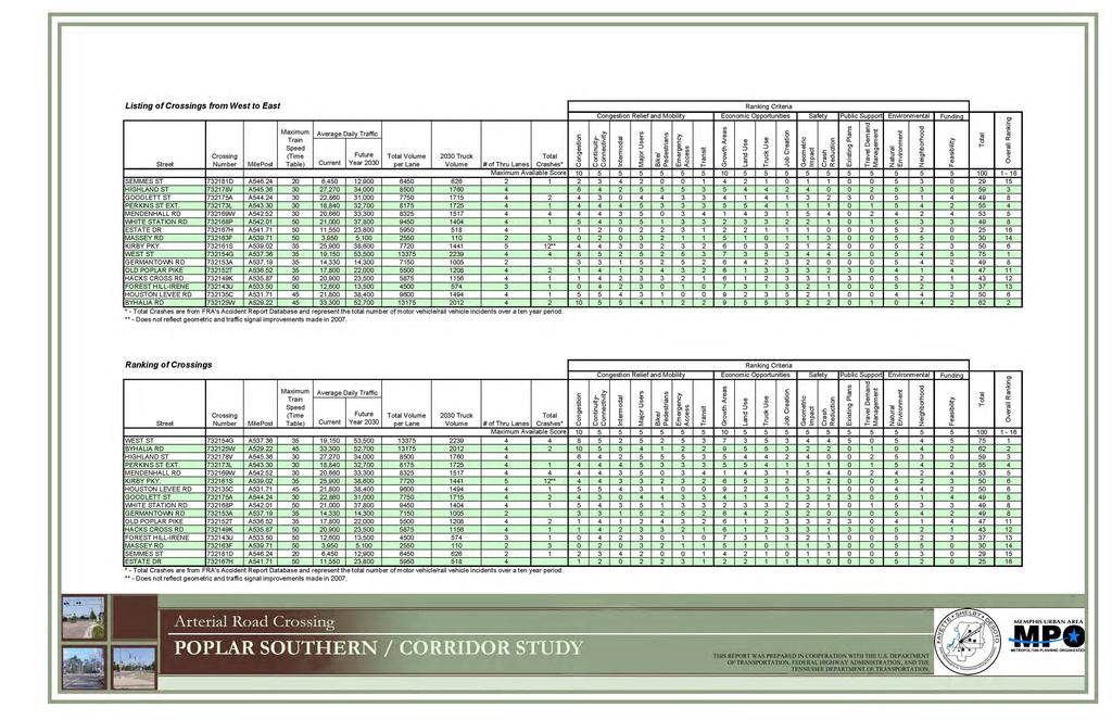
24 Historic sites and historic districts Obtained from the National Register of Historic Places Cultural resources such as schools and parks GIS data provided by the MPO 14. Major Traffic Generators A large part of the data collection was focused on the major traffic generators associated with each arterial crossing along the corridor. Generators well beyond the extents of the ½ mile wide coridor impact the amount of traffic at each crossing. This study attempted to consider all of the traffic generators within and beyond the study limits that might have impact on the study. Traffic generator categories researched along the corridor include: shopping and business centers, hospitals, parks/ greenways, fire and police stations, and schools. Several of these are both vehicular and pedestrian traffic generators, including schools, parks, shopping centers and restaurants. Other traffic generators include adjacent neighborhoods. 15. Existing Topography To aid with the alternatives analysis, contour information was obtained from the Shelby County Government in a GIS file format. Two-foot increments contours were provided for the areas surrounding each of the initial sixteen crossings evaluated as part of this study. 16. Arterial Road Crossing Data Exhibits Arterial Road Crossing Exhibits were developed for each of the sixteen arterial roads that cross the Norfolk Southern Railroad and arranged in order from west to east along the study corridor. Important crossing data related to each road is provided. Each figure illustrates a ¼ mile and ½ mile radius from the crossing and shows the key traffic generators within these areas. A perspective aerial image shows the land uses at each corner of the road and railroad intersection. The Arterial Road Crossing Data and Analysis exhibits can be found in Appendix F. 17. Preliminary Matrix Ranking System The methodology for determining the ranking criteria is based on a format similar to that used by the MPO. The major categories addressed were Congestion Relief and Mobility, Economic Opportunities, Safety, Public Support, Environment, and Funding. The Ranking Matrix/ Ranking Criteria chart, shown in Figure 1, ranks 16
25 the sixteen arterial road at-grade crossings of the Norfolk Southern Railroad within the study corridor limits. The first chart lists the roads and their rankings from west to east along the study corridor. The second chart lists the roads as they were ranked with the first road listed receiving the highest total point score. The top six arterial road grade crossings are West Street, Byhalia Road, Highland Avenue, Perkins Extended, and Mendenhall Road, with Kirby Parkway and Houston Levee Road equally ranked sixth. The Ranking Criteria Matrix and Crossing Attributes can be found in Appendix G. 17
26
27 C. Project Prioritization 1. Selection of Two Representative Crossing Locations The two crossings to be evaluated in more detail can be used to generally determine the costs and benefits at other similar crossings within the study area. Two criteria were used to categorize crossings with similar characteristics: adjacent land use and vertical roadway and railroad geometry. Three types of land uses were identified for the sixteen crossings: Commercial/Office/ Industrial, Residential, and Hybrid (a combination of commercial, office, and residential). The sixteen arterial crossings were then sorted by these criteria. The vertical geometry criterion refers to the existing topographical condition of the roadway and railroad as they approach a grade crossing. This includes those where the roadway approach is at different elevations than the railroad tracks, and those where the roadway approach is generally at the same elevation as the railroad tracks. Within each of these criteria, the sixteen arterial crossings were listed in order of the Preliminary Matrix Ranking System as described previously in Section IV.B.17. Based on this ranking, six recommended crossings were selected: West Street Byhalia Road Perkins Extended Mendenhall Road Kirby Parkway Houston Levee Road Through a series of meetings of the MPO staff and the study team, the at-grade crossings at Mendenhall Road and Houston Levee Road were selected as the two crossings having the most similar characteristics and that are the most representative crossings located within the corridor study limits. Mendenhall Road represents an urban crossing with a dense surrounding of commercial, office, and adjacent residential land uses and a difference in elevation between the road and the railroad. Houston Levee Road represents a suburban crossing with less dense commercial land uses nearby, strong road connectivity, and relatively flat vertical geometry. The MPO meeting agenda, meeting minutes, and progress status reports can be found in Appendix H. 19
28 D. Potential Alternative Solutions Four potential alternative solutions were identified for each of the two representative crossings, as listed below: Mendenhall Road 1. Do Nothing Alternative Existing geometry and traffic control to remain unchanged. 2. Option A Grade separation with the railroad over Mendenhall Road. The railroad would stay in its current location and Mendenhall Road and Poplar Avenue would be lowered approximately 28 feet below the existing grade. 3. Option B Grade separation with the railroad over Mendenhall Road. The grades of the railroad, Mendenhall, and Poplar would be adjusted. The railroad would be raised approximately 17 feet with Poplar Avenue and Mendenhall Road lowered no more than 11 feet below the existing grade in order to maintain gravity drainage flow. 4. Option C Safety improvements. Improvements may include lowering the railroad to remove the existing vertical elevation change at the crossing and installing raised medians along Mendenhall Road or four quadrant gates at the crossing. Option A was selected for the detailed study of the Mendenhall Road crossing for several reasons. First, the approach of Mendenhall Road from the south is approximately 12 feet lower vertically than the railroad 40% of the needed vertical separation. Second, the proximity and impacts to other crossings (i.e., Truse Road, Colonial Road, and White Station Road) limited changing the vertical geometry of the railroad at this location. While raising the elevation of the railroad at this crossing would assist in alleviating potential drainage issues, it would require the permanent closure of the Truse Road crossing and the reconstruction of the White Station Road crossing. Houston Levee Road 1. Do Nothing Alternative Existing geometry and traffic control to remain unchanged. 2. Option A Grade separation with the railroad over Houston Levee Road. The railroad would stay in its current location and Houston Levee Road and Poplar Avenue would be lowered approximately 27 feet below existing grade. 20
29 3. Option B Grade separation with the railroad over Houston Levee Road. The grades of the railroad, Houston Levee Road, and Poplar Avenue would be adjusted. The railroad would be raised approximately 15 feet with Poplar Avenue and Houston Levee Road lowered no more than 12 feet below the existing grade in order to maintain gravity drainage flow. 4. Option C Safety improvements. Improvements may include video camera enforcement at the crossing ticketing motorists that violate the gate arms by running through a crossing when a train is approaching. There are a limited number of additional safety improvements that could be made because this crossing has recently been updated. Option B was selected for detailed study of the Houston Levee Road crossing. The combination of raising the railroad 15 feet and lowering the roadways 12 feet to achieve the required vertical separation limits the construction impacts to adjacent properties. The adjacent crossing locations are far enough away that they would not be impacted. V. Mendenhall Road Alternative Analysis Analyses were conducted to determine the construction and community impacts associated with the alternative solution chosen for Mendenhall Road. Due to the change in the elevation of the roads, the improvements made at this intersection would require more than roadway and railroad improvements. The lowering of the roadway system would require a major redevelopment of the immediate area. The information that follows provides a detailed description of the selected alternative and identifies the impacts, redevelopment opportunities, probable costs, and benefit/cost ratios associated with the improvements that potentially could be provided by the grade-separated crossing. The design standards of the Tennessee Department of Transportation, the City of Memphis, and the Norfolk Southern Railroad were used in the development of the alternative solution. A. Description of the Alternative The alternative selected for further analysis for the Mendenhall Road crossing was Option A. This option provides for constructing a gradeseparated crossing by lowering Mendenhall Road and Poplar Avenue approximately 28 feet and constructing a railroad bridge at the same approximate elevation as the existing rail. Mendenhall Road and 21
30 Poplar Avenue would be reconstructed with the same number of lanes using current design standards for lane widths. The current lane widths on Poplar Avenue are substandard, due in part to the restricted right-of-way width. Reconstructing Mendenhall Road and Poplar Avenue to current design standards would require additional right-ofway. Typical Roadway Sections for Poplar Avenue and Mendenhall Road are shown in Figure 2. Roadway profiles were developed using a 40-mile per hour design speed. The Roadway and Railroad Profiles for the Mendenhall Road crossing can be found in Appendix I. 22

31 ROADWAYTYPICALSECTIONS FIGURE2
32 B. Construction Impacts Limits of Construction The limits of construction necessary for reconstructing the roadway, installing a railroad bridge, and the redevelopment of the impacted adjacent properties are shown on Figure 3. On Mendenhall Road, the construction would begin approximately 100 feet south of Spottswood Avenue and extend to 100 feet north of William Arnold Road. On Poplar Avenue, the construction would begin just east of Erin Drive and extend to approximately 200 west of Truse Parkway. 24


33 MENDENHALL ROAD LIMITS OF STUDY IMPACTS FIGURE 3 SOUTHERN AVE. ERIN DR. BLACK RD. POPLAR AVE. MENDENHALL RD. LIMITS OF AREA Mendenhall Road Limits of Study Impacts The Mendenhall Road Limits of Study Impacts exhibit illustrates the area within the study limits and is approximately 31.2 acres including acreage inside and outside of the right-of-way. The limits are based on the extent of land impacted due to the grade-separated crossing improvements. Due to the extreme change in elevation of the road, Poplar and Mendenhall are lowered approximately 28 feet, the land adjacent to the right-of-way will also be impacted. One of the key components to the success of a business is the visibility and accessibility of the building to the user. Therefore the approach was taken to keep the elevation of the buildings relative to the elevation of the new road. This could be accomplished by grading parcels adjacent to the roadway to an elevation relative to the new roadway elevation. The remaining parcels would be graded so as to take up the necessary grade change at the rear of the properties. Retaining walls, if required, would be located at the rear of the properties. The limits of area line represents the point where the proposed grade ties back into the existing grade. BERRY RD SOUTHERN AVE. Mendenhall Road Crossing Data Current Conditions Prior to Grade-Separated Crossing Improvements Traffic Volume (AADT): Current: 20,660 Future (2030): 33,300 (AADT - Annual Average Daily Traffic) MOSS RD. SPOTTSWOOD AVE. MT. MORIAH RD. 70' Right-of-Way with 4-Thru Lanes Crash Count (Motor Vehicle/Rail Vehicle): 4 (Based on FRA's Accident Report Database over a ten year period) IVY RD. TRUSE PKWY NORFOLK-SOUTHERN RAILROAD AERIAL DATE: 2008 NORTH SCALE: N.T.S. PARCEL DATA SOURCE: SHELBY COUNTY REGISTER OF DEEDS THIS REPORT WAS PREPARED IN COOPERATION WITH THE U.S. DEPARTMENT OF TRANSPORTATION, FEDERAL HIGHWAY ADMINISTRATION, AND THE TENNESSEE DEPARTMENT OF TRANSPORTATION.
34 1. Traffic Impacts Construction of a grade-separated crossing is a major undertaking. Maintenance of traffic through the area during construction would require a detailed, multi-staged traffic control plan. This alternative would require lanes and/or entire streets to be closed to complete construction. A schematic staging plan was developed to illustrate maintenance of traffic during construction. The goal was to maintain a minimum of four lanes of traffic on Poplar Avenue throughout construction. The street closures with their associated detours would have a negative impact on traffic throughout the construction period. Business owners, their employees, and their patrons would feel the effects in lost time and revenue. Emergency responders (police, fire, and ambulance) would have delays and would have to adjust their response routes accordingly. Mass transit would have to adjust their routes likewise. In general, any resident, business, or service located within the neighborhoods surrounding the crossing would have to make adjustments to their travel routines. For the intersection of Mendenhall Road at Poplar Avenue, traffic control is expected to generally occur in two phases during construction. As part of Phase 1, Mendenhall Road would be closed south of Poplar Avenue. Traffic along Mendenhall Road south of the closure would be routed from Mt. Moriah to Truse Parkway to Poplar Avenue to Mendenhall Road north of Poplar Avenue. It is anticipated that Mendenhall Road south of Poplar Avenue would be closed to traffic throughout the construction. During Phase 2, Mendenhall Road would be closed both north and south of Poplar Avenue. During this phase, traffic would be routed from Mt. Moriah Road to Park Avenue to White Station Road to Sanderlin Avenue to Mendenhall Road. The alternative temporary construction detour routes for the Mendenhall Road crossing are shown in the Mendenhall Road Traffic Control Schematic, Figure 4. 26


35 MENDENHALL ROAD TRAFFIC CONTROL SCHEMATIC
36 2. Grading Impacts With the grade changes associated with a grade-separated crossing, a conceptual grading plan was developed to determine the impacts to the adjacent property. One of the key components to the success of a business is the visibility and accessibility of the building to the user. Therefore the approach was taken to keep the elevation of the buildings relative to the elevation of the new road. This could be accomplished by grading parcels adjacent to the roadway to an elevation relative to the new roadway elevation. The remaining parcels would be graded as to take up the necessary grade change at the rear of the properties. The limits of redevelopment line represents the point at which proposed grading ties to the existing topography or at which point a retaining wall is required. 3. Utility Impacts Utility information for the Poplar Avenue at Mendenhall Road crossing was provided by MLG&W. This information included the location of water, gas, and electric facilities adjacent to the intersection. There were no major electrical transmission towers or gas pipelines identified and utility impacts were limited to local service lines, three phase electrical transmission lines, gas mains, and water mains. 4. Stormwater Management Of concern for the rail crossing was the improvements required for adequate stormwater drainage. As a result of lowering the roadways, storm drainage would need to be modified based on the new roadway elevations. The revised profile geometry would create a sump condition for stormwater drainage. This intersection would require the installation of a pump station. The proposed station would pump stormwater south along Mendenhall Road to an existing drainage canal flowing to Cherry Bayou. A new closed drainage system would be constructed as part of the roadway reconstruction. The natural drainage basin would be modified with the improvements. Generally, the ridge separating the Wolf River and Nonconnah Creek drainage basins follows the Poplar Avenue and the Norfolk Southern Railroad. With the Mendenhall Road crossing, construction of a grade separation would result in approximately 11 acres being removed from the Wolf River drainage basin and added to the Nonconnah Creek drainage basin. 28
37 C. Neighborhood Impacts 1. Business and Community Impacts It would be essential that the finished floor elevations of the businesses along Mendenhall Road and Poplar Avenue relate to the new elevations of those roadways. The businesses closest to the intersection would be approximately 28 feet lower than their current elevation. The limits of redevelopment define those parcels that would be affected by the change in elevation required under Option A. During the construction and redevelopment period numerous businesses would have to be relocated (at least temporarily). The Mendenhall Area Map (Figure 5) illustrates the existing parcels within the limits of the redevelopment area that would be affected by the construction. The figures indicate which businesses would be removed and which would be maintained yet impacted due to the grade-separated crossing improvements specific to each intersection. The businesses impacted and/or removed by improvements to the railroad are highlighted and summarized below. Retail 158,550 SF +/- Removed (53 Businesses) 81,784 SF +/- Impacted* (6 Businesses) Office 103,746 SF +/- Removed (14 Offices) Residential 1.05 acres +/- Removed (2 Single-Family Residences) * Impacted businesses or offices are those that would not be removed due to construction of the grade-separated crossing, but would be impacted by construction due to loss of business, construction impacts, or delays. 29
 F 0.62 AC. C-H 1. James Gattas Jewelers G 1.75 AC. C-H H 1.03 AC. C-H I 0.75 AC. C-H J 0.78 AC. C-H K 0.10 AC. C-H L 0.19 AC. C-H M 0.19 AC. C-H N 0.13 AC.")


38 PARCEL ID ACREAGE ZONING BUSINESSES A 0.51 AC. C-H BP Gas Station B 0.30 AC. C-H The Spirits Shoppe C 4.39 AC. C-H 1. Blockbuster Video Erinway 2. Hollywood Feed 5. Coming Attraction D 0.10 AC. C-H Vacant E 1.37 AC. C-H Vacant (Bank) F 0.62 AC. C-H 1. James Gattas Jewelers G 1.75 AC. C-H H 1.03 AC. C-H I 0.75 AC. C-H J 0.78 AC. C-H K 0.10 AC. C-H L 0.19 AC. C-H M 0.19 AC. C-H N 0.13 AC. C-H O 0.22 AC. C-H P 0.23 AC. C-H Q 0.20 AC. C-H R 0.52 AC. C-H BF 0.33 AC. C-H BG 0.31 AC. C-H BH 1.21 AC. C-H S 0.52 AC. C-H T 0.14 AC. C-L U 0.38 AC. C-L V 0.40 AC. C-L W 0.26 AC. C-L X 4.16 AC. RS-10 Y 5.73 AC. C-H Z 0.37 AC. C-H AA 0.41 AC. C-H AB 0.82 AC. C-H AC 0.86 AC. C-H BI AD AE AF AG 0.54 AC. C-H 3. Guy's Tuxedo 4. Huey's 2. Jaffe Studio 3. Cavalier Cleaners Public Storage Chick-Fil-A 1. AT&T 2. Life Blood Mr. Pride Car Wash Mr. Pride Car Wash The Shops of Ann Addler Belmont Grill Belmont Grill 1. Long Law Firm 2. Ratcliff's Shoe Service 3. Yoga Memphis All About Pets Handiwork Jewelry Seabrook Decorating 1. The Polished Pair 2. Bomar & Brown, LLC Browndog Lodge AT&T Cadence Banking Memphis Symphony Orchestra Arts Memphis Folk's Folly Folk's Folly New Philadelphia Missionary Baptist Church Mendenhall Commons Fire Station # 21 American Care Car Centers McAlister's Deli Collier Insurance Vacant Stamps & Coins Ben & Jerry's Tate Professional Jewelers Polished Nails & Spa Gil & Co AC. C-H First Tennessee Bank 0.09 AC. C-H First Tennessee Bank 1.02 AC. C-H Houston's Restaurant 6.15 AC. C-H 1. Office Depot White 2. Whole Foods Station Commons AH 0.51 AC. C-H 1. Daniel Yaroubian Jewelers 2. Advanced Computer Center 3. Nails by Nicole 4. Sahara Cafe 5. Pita Wraps 6. Smooth Moves BLDG S.F. / UNITS 1,044 +/- 2,228 +/- 30,000 +/- (total) 1,724 +/- 11,773 +/- 10,000 +/- (total) 4,837 +/- 4,545 +/- 9,884 +/- (total) 3,966 +/- 4,320 +/- 2,265 +/- 1,976 +/- 3,600 +/- (total) 2,658 +/- 2,952 +/- 7,959 +/- 4,000 +/- (total) 2,800 +/- 23,500 +/- 5,634 +/- 2,384 +/- 3,970 +/- 6,643 +/- 4,010 +/- 9,760 +/- 6,089 +/- 3,818 +/- 25,401 +/- 10,264 +/- (total) 61,144 +/- 7,570 +/- 68,792 +/- (total) 8,800 +/- (total) AV A ST. NICK DR. POPLAR AVE. D ST. NICK RD. B SCALE: 1"=500' ORIGINAL SHEET SIZE: 11X17 MENDENHALL AREA MAP FIGURE 5 ERIN DR. SOUTHERN AVE. BERRY RD. BERRY RD. C MOSS RD. SPOTTSWOOD AVE. IVY RD. WILLIAM ARNOLD RD. BLACK RD. E F G H I AW C-L U T BH S BF R BG Q J O P AM L M N CARNES RD. W V MENDENHALL RD ZONING LEGEND - Memphis and Shelby County Zoning Map February 21, 2008 C-H C-L C-P C-H Highway Commercial Local Commercial C-P R-S10 Planned Commercial O-G O-L R-D C-H C-H R-S10 O-L K C-P X AN R-MM General Office Limited Office Duplex Residential AE SOUTHERN AVE. AO AP Z AA AB AC AD C-L MT. MORIAH RD. AF AQ Y AR AS NORFOLK-SOUTHERN RAILROAD AT AU BI AX BJ BK C-H BL C-L AG LIMITS OF AREA SANDERLIN AVE AY AZ R-MM RS-10 AH WINTON ST. BB R-D BC C-H C-H AI TRUSE PKWY. BD R-D AJ BUSINESSES REMOVED BUSINESSES IMPACTED Multiple-Family Residential Single-Family Residential BE AK AL NORTH SOURCE: SHELBY COUNTY REGISTER OF DEEDS PARCEL ID ACREAGE ZONING BUSINESSES AI 9.39 AC. C-H White Station Tower AJ 1.38 AC. C-H Poplar-White Station Library 10,125 +/- AK 7.79 AC. C-H Clark Tower 649,000 +/- AL 0.71 AC. C-H Carrabba's Italian Grill 6,474 +/- AM 1.68 AC. C-P 1. Tobacco Corner 3,500 +/- 2. Beltone AN AO AP 2.33 AC. C-L AQ 0.18 AC. C-L AR 0.34 AC. C-L AS AT AU AV 5.74 AC. R-MM 0.56 AC. O-G 803 Mt. Moriah 0.34 AC AC. C-L C-L 0.41 AC. C-L 0.08 AC. C-H 3. Memphis Jewelry 4. Flowers & Etc. 5. Boyer Hair Group 6. The Book Place 7. Simply Divine 8. The Clothes Line 9. Yarniverse 10. Nails by Ruthie 11. A Little English Interiors 12. Bogie's Delicatessen The Mendenwood Apartments 1. UTHE Insurance 2. Financial Services 3. Regal Securities 3. East Memphis Electrolysis 4. LLW Architects, Inc. 5. Dr. Marvin Klein 6. Zen Bio, Inc. 7. Rubert Realty 8. Moss/Rubert Investments 1. Half Shell 2. Allied Medical 3. At Home Medical Supply 4. Wild Birds Unlimited 5. Midnight Sun Tanning 6. Epic Salon The Urban Gardener 1. Liquor and Wine Depot 2. Donuts 1. Batteries Plus 2. Quizno's Subs 1. Thomas C. Patterson DDS 2. George S. Flinn Jr., MD 3. Kid STAT Jack Morris Auto 1. The Final Touch 2. FSBO Magazine AW RS-10 Colonial View Subdivision AX 0.55 AC. C-H 1. Goodwill 2. All About Pets AY 0.35 AC. C-H 1. Sherwin Williams Paint 2. Dent Doctor 4,949 +/- (total) 1,225 +/- 3,900 +/- (total) 3,000 +/- (total) 7,181 +/- (total) 2,364+/- (total) 6,449 +/- 6,449 +/- 4,853 +/- 9,706 +/- (total) 2,512 +/- 3,000 +/- 5,669 +/- (total) 5,310 +/- (total) 7,314 +/- (total) 5,239 +/- 2,192 +/- (total) AZ 0.34 AC. C-H Sunshine Car Wash 3,435 +/- BB 5.51 AC. R-D Schnucks Grocery 55,068 +/- BC 0.94 AC. C-H Schnucks Express Gas BD 1.19 AC. R-D 1. The Vitamin Shoppe 2. Men's Warehouse 8,261 +/- (total) BLDG S.F. / UNITS 276,229 +/- 3. Uptech Computer BJ 0.28 AC. C-H McGehee Clinic for Animals 4,615+/- BK 0.27 AC. C-H Lunt & Co. Financial Planning 1,568 +/- BL 0.53 AC. C-L MPE Suites ,184 +/- 2. Mewtopia 3. FSBO 2,451 +/- 4,368 +/- (total) 7,182 +/- (total) 2,204 +/- 8,600 +/- (total) BE AC. R-D The Home Depot 101,860 +/- THIS REPORT WAS PREPARED IN COOPERATION WITH THE U.S. DEPARTMENT OF TRANSPORTATION, FEDERAL HIGHWAY ADMINISTRATION, AND THE TENNESSEE DEPARTMENT OF TRANSPORTATION.
39 D. Post Construction Community Impacts 1. General Neighborhood Impacts Construction of the selected alternatives would have an impact on the surrounding neighborhood after the construction period has ended. One notable impact would be the loss of current businesses. While new construction has the potential to attract businesses, there is the possibility that businesses lost during the construction period would either relocate or would remain closed. Another potential impact is the increase in traffic that would result from a grade-separated crossing. The potential of getting caught by a train at non-grade separated crossings would cause many drivers to select routes that include the separation. This would be especially significant at rush hour where commuters, seeking to save time, may find a heavily congested intersection and a resulting delay. 2. Impacts to Safety It is anticipated that the safety of the crossing would be improved with construction of the selected alternative. By providing a grade separation, vehicles traveling along Mendenhall Road would not cross the rail line at-grade and conflict points associated with the rail crossing would be eliminated, removing the potential for a vehicle/rail crash. Over a ten-year period from 1999 to 2008, there were four documented cases of a rail/highway vehicle crash at the Mendenhall Road crossing. 3. Impacts to Congestion Construction of the selected alternatives would reduce congestion at the intersection. By eliminating the at-grade crossing at Mendenhall Road, the route would remain open as trains pass through the area. This would reduce non-recurring delay by allowing vehicles to cycle through the intersection as trains pass through the area. It is estimated that as many as 20 trains per day would use the rail line in the horizon year of It is also estimated that vehicles encountering a train would experience a three-minute delay on average. Using these estimates and the anticipated number of vehicles using the crossings in the horizon year, approximately 65 to 70 hours of delay per day would be eliminated with a grade separation. 4. Environmental Impacts The environmental impacts of constructing the improvements at the Mendenhall Road crossing were reviewed. The environmental issues identified within the study boundaries included impacts to 31
40 floodplains, rare species habitat, ecological sites, superfund sites, hazardous waste generators, toxic chemical release sites, air release sites, and water discharge sites. Sites within a ¼ mile radius of the study intersections were noted. The intersection of Poplar Avenue at Mendenhall Road was found to have one air release site located adjacent to the project. There would be positive impacts to air quality provided by the grade separation due to reductions in vehicles delayed and idling as vehicles would no longer be delayed or stopped by railroad activity. 5. Regional and Local Economic Impacts The REMI (Regional Economic Models, Inc) model, an advanced economic impact modeling software, was used to estimate the total direct, indirect, and induced impacts of the construction of the Mendenhall Road grade separation. There are two major categories of potential impacts: One-time impacts, which result from the construction of the improvements occurring once during the construction period. Ongoing impacts, which result from increased quality of life, personal income, and labor productivity created by the travel time savings. Both types of impacts have been evaluated in this report, and the results are highlighted as follows: Construction impacts - These impacts are estimated to occur evenly over the life of the construction, and would not recur after the construction period. Based on the analysis, the construction of the underpass would result in the creation of 427 jobs and create a total $50.4 million increase in output to firms in Shelby County. Ongoing impacts The travel time savings created by the grade separation would result in an increase of $2.9 million in output (in 2010 constant dollars) and an associated additional 12 jobs in 2020 within Shelby County on an annual basis. By 2030, the increase in personal income in the region, in 2030 dollars, is estimated to reach close to $2.3 million. These impacts recur year after year. 6. Impacts to Transit Construction would have a minor impact to adjacent transit routes. Currently, the Mendenhall Road intersection has two bus routes that cross the rail line and a third that travels along Poplar 32
41 Avenue. The construction of a grade-separated crossing at this intersection would improve safety and reduce delay for those transit routes. 7. Bicycle Lanes The rail crossing at Mendenhall Road was investigated to determine if bicycle lanes would be required based on recommendations in the 2030 Long Range Transportation Plan (LRTP). The intersection of Poplar Avenue at Mendenhall Road is not proposed to have bicycle lanes and it is not recommended in the LRTP. 8. Minor Crossing and Street Closures With construction of the selected alternative for Poplar Avenue at Mendenhall Road, minor streets located adjacent to the crossing would require closure. These streets include Moss Road at Poplar Avenue and Southern Avenue at Mendenhall Road. These road closures would be required because of vertical geometry changes to Mendenhall Road and the Norfolk Southern Railroad. It is recommended that Moss Road, a minor crossing, be converted to a cul-de-sac and the Southern Avenue alignment be modified to intersect Mendenhall Road further to the south. It is also recommended that Black Road be realigned on the east side of Mendenhall Road to align with its west side counterpart. E. Horizontal and Vertical Rail Geometry Improvements to the horizontal and vertical geometry for the rail line were established using Norfolk Southern s design criteria. To minimize the impact to the rail line, horizontal geometry was not modified. The design criteria used for this study can be found in Appendix D. F. Limits of Redevelopment The Mendenhall Road Limits of Study Impacts exhibit illustrates the area within the study limits that would be impacted by the railroad and roadway improvements made for a grade-separated crossing. As discussed previously in Section V.B.2, due to the extreme change in elevation of the roads, the land adjacent to the right-of-way would be significantly impacted. (See Figure 3). 33
42 G. Conceptual Redevelopment Plan 1. Approach Changes to the existing roadway elevations, due to the construction of the grade-separated crossing, would require the redevelopment of the area surrounding these crossings. Consistent with the Sustainable Shelby Initiative and the Shelby County Unified Development Code (UDC), redevelopment of these parcels would likely result in the property being developed with more density and with a mixed-use approach. A mixed-use planning approach with the following components were included: Live/Work Units with office or retail on the first floor and residential above (three-story), Retail (one-story), Mixed-Use Retail and Office (two-story), and Mixed-Use Retail and Residential (six-story). A parking analysis was performed which maximized the building square footage while provided adequate surface parking. The residential element would serve to increase the population in the area and provide more patrons for the mixed-use retail and office components. Seventeen live-work units south of Poplar Avenue provide buildings with both office and retail space on the bottom floor with residential space above. In addition, a mid-rise retail and residential building would introduce a new concept to the area. It would be important to maintain the views of the property north and south of the grade separation, which would likely be blocked by a normal 170-foot span bridge. In order to open the views the bridge span for the railroad crossing could be increased from 170 feet to 340 feet, to provide a wider opening at the crossing and allow drivers to see businesses on the opposite side of the railroad track. The following exhibit, Figure 6, illustrates the Conceptual Redevelopment Plan for the Mendenhall Road crossing. Also included is a Conceptual Redevelopment Plan Products chart, Figure 7, listing the proposed and existing land use products. While the Conceptual Redevelopment Plan illustrates the specific crossing, the design principles are representative and can be used for other crossings along the corridor to create a redevelopment plan specific to other intersections. The Conceptual 34
43 Redevelopment Plan reflects only one possible scenario and should not be considered the only option for redevelopment. 35


44 MENDENHALL REDEVELOPMENT CONCEPT MENDENHALL CONCEPTUAL REDEVELOPMENT PLAN AMERICAN CAR CARE CENTERS C-H BLACK R D. R. MALCO PARADISO C-H MCALISTER'S DELI C-H PUBLIC STORAGE C-H LIMITS OF ARE A MIXEDUSE ER I ND ERINWAY C-H RETAIL RD. WHITE STATION COMMONS C-H MENDE POP LAR AVE. MIXEDUSE NHALL RETAIL SOU THE RN A VE. EX. WHOLE FOODS RETAIL EX. OFFICE DEPOT RAILROAD BRIDGE LIVE/ WORK WHITE STATION TOWER C-H 0 42 COLONIAL VIEW SUBDIVISION RS CONCEPTUAL MASTER PLAN USES 0 MOSS RD LIVE/WORK: OFFICE/RESIDENTIAL 3-STORY LIVE/WORK: RETAIL/RESIDENTIAL 3-STORY LIVE/ WORK RETAIL 1-STORY NO RF OL KSO SCHNUCKS UT EXPRESS GAS HE C-H RN 50 SPOTTSWOOD AVE MIXED-USE: RETAIL/RESIDENTIAL 6-STORY 0 52 TR US EP KW Y. MIXED-USE MIXED-USE: RETAIL/OFFICE 2-STORY 0 51 IVY R D. BERRY RD. FIGURE RA IL RO AD NORTH SCALE: N.T.S. THE MENDENWOOD APARTMENTS R-MM SCHNUCKS GROCERY R-DTHIS REPORT WAS PREPARED IN COOPERATION WITH THE U.S. DEPARTMENT OF TRANSPORTATION, FEDERAL HIGHWAY ADMINISTRATION, AND THE TENNESSEE DEPARTMENT OF TRANSPORTATION.

45
46 2. Conceptual Redevelopment Plan Imaging Following is a series of redevelopment plan imaging exhibits, Figures 8-11, illustrating the mixed-use redevelopment approach taken at the Mendenhall Road crossing. The redevelopment plan imaging exhibits are based on the Conceptual Redevelopment Plan. These illustrations reflect only one of many possible scenarios for development of the area. 38


47 MENDENHALL CONCEPTUAL REDEVELOPMENT PLAN IMAGING FIGURE 8 Mendenhall POPLAR AVE MENDENHALL RD Poplar Avenue Limits of Study Impacts MENDENHALL RD POPLAR AVE A SketchUp rendering of the Conceptual Redevelopment Plan for the intersection at Mendenhall Road and Poplar Avenue. integrating retail, office and residential uses. The plan is a mixed-use concept Conceptual Redevelopment Plan NORTH THIS REPORT WAS PREPARED IN COOPERATION WITH THE U.S. DEPARTMENT OF TRANSPORTATION, FEDERAL HIGHWAY ADMINISTRATION, AND THE TENNESSEE DEPARTMENT OF TRANSPORTATION.


48 MENDENHALL CONCEPTUAL REDEVELOPMENT PLAN IMAGING FIGURE 9 VIEW A: Conceptual bird's eye view looking southeast across the railroad bridge. Uses south of Poplar include: retail, live/work, and mixed-use retail with residential. A POPLAR AVE MENDENHALL RD VIEW B: Conceptual bird's eye view looking northwest across the Mendenhall and Poplar intersection. Retail and two-story mixed-use buildings front Mendenhall. D B C NORTH VIEW C: Conceptual bird's eye view looking northwest at live/work units fronting Mendenhall. Live/work units are three-stories with office and residential uses. VIEW D: Conceptual bird's eye view looking northeast at retail and mixed-use buildings. Existing Whole Foods, Office Depot, Clark Tower, and White Station Tower behind. THIS REPORT WAS PREPARED IN COOPERATION WITH THE U.S. DEPARTMENT OF TRANSPORTATION, FEDERAL HIGHWAY ADMINISTRATION, AND THE TENNESSEE DEPARTMENT OF TRANSPORTATION.


49 MENDENHALL INTERSECTION CONCEPTUAL BEFORE AND AFTER IMAGING FIGURE 10 A POPLAR AVE VIEW A BEFORE: Looking east along Poplar, First Tennessee Bank is located at the corner of Poplar and Mendenhall with restaurants and retail buildings adjacent. NORFOLK SOUTHERN RAILROAD RD MENDENHALL SOUTHERN AVE NORTH SCALE: N.T.S. VIEW A AFTER: Conceptual view looking east at the Mendenhall and Poplar intersection. An improved right-of-way is introduced with street trees located in a grass strip behind the curb and lined with five-foot wide sidewalks. In the northeast quadrant one-story retail uses face Poplar with a mixture of both retail and office buildings facing Mendenhall. THIS REPORT WAS PREPARED IN COOPERATION WITH THE U.S. DEPARTMENT OF TRANSPORTATION, FEDERAL HIGHWAY ADMINISTRATION, AND THE TENNESSEE DEPARTMENT OF TRANSPORTATION.


50 MENDENHALL INTERSECTION CONCEPTUAL BEFORE AND AFTER IMAGING B FIGURE 11 POPLAR AVE NORFOLK SOUTHERN RAILROAD VIEW B BEFORE: Looking across Poplar towards the southeast corner of Mendenhall and Poplar. RD MENDENHALL SOUTHERN AVE SCALE: N.T.S. NORTH VIEW B AFTER: Conceptual view of the southeast corner of Mendenhall and Poplar. The railroad stayed in its current location and Mendenhall and Poplar are lowered approximately 28 feet below the existing grade. VIEW B AFTER: Conceptual bird's eye view of the southeast corner of Mendenhall and Poplar. The six-story mixed-use building can be seen over the railroad bridge, adding additional retail square footage on the first floor and residential lofts above, a second floor garage serves as parking for the residents. THIS REPORT WAS PREPARED IN COOPERATION WITH THE U.S. DEPARTMENT OF TRANSPORTATION, FEDERAL HIGHWAY ADMINISTRATION, AND THE TENNESSEE DEPARTMENT OF TRANSPORTATION.
51 H. Opinion of Probable Cost An opinion of probable cost data sheet was developed to include the probable costs of the proposed roadway and railroad improvements and the associated conceptual redevelopment plan at Mendenhall Road. There are three potential categories of cost related to this project: costs associated with the grade-separated crossing improvements, costs associated with the redevelopment, and costs of impacts beyond the physical limits of this study. The costs associated with the grade-separated crossing improvements are included in the Benefit/Cost Ratio analysis as discussed in the next section. The costs associated with redevelopment are not included in the Benefit/Cost Ratio analysis. The redevelopment cost is not included because it is assumed that economic growth would occur in the city regardless of whether or not the grade separation is built. The improvements at Mendenhall Road could concentrate the economic growth at this intersection instead of other locations in the city; however, the net local economic growth would not change and is viewed only as a geographic shift. Category 1: The grade-separated crossing improvements include costs associated with rights-of-way (acquisition, relocation, and goodwill), utility relocation, construction costs, and preliminary engineering. The total cost associated with grade-separated crossing improvements is $63.9 million, as detailed below: Right-of-Way Utility Relocation Construction Costs Preliminary Engineering TOTAL 31.7 million 2.4 million 27.1 million 2.7 million 63.9 million It is important to note that the railroad bridge cost includes a span twice as long as needed in order to create view corridors to the development on either side of the railroad. This is key to the sustainability of the retail uses in the area. The Economic Impact Report can be found in Appendix J. Category 2: The breakdown of the costs associated with the conceptual redevelopment at the intersection includes demolition of existing facilities and redevelopment costs including proposed building costs and amenities. The total construction redevelopment cost for the Mendenhall Road scenario is estimated to be approximately $94.1 million. This figure does not include the portion of property acquisition and building demolition costs due to right-of-way 43
52 improvements included in the Category 1 costs. The probable costs for the redevelopment are only representative of the concept scenario modeled for the intersection. If a different redevelopment program is chosen, then the probable cost of construction would change accordingly. A detailed listing of the Opinion of Probable Costs for the Mendenhall Road improvements and conceptual redevelopment plan can be found in Appendix K. Category 3: Costs include all costs or benefits accrued due to impacts outside the study limits. These costs or benefits could include improvements to traffic flow or safety resulting from traffic diversion from other roads or intersections, increased exposure for retail businesses, or increased traffic noise for residential properties. Even though these benefits or impacts may be real, they have not been quantified or included in this evaluation because they are for properties or areas that are beyond the physical limits of this study. I. Benefit/Cost Ratio The economic impact evaluation examines the impact of the gradeseparated crossing from the perspective of the Memphis Metropolitan Area regional economy. Benefits From a project perspective, the benefits include the time savings which accrue to motorists (both passenger car and truck traffic), air quality impacts, and crash reduction savings. The time savings to motorists have been divided into household sector benefits and employment sector benefits. The time savings to the household sector allows motorist to spend a bit more time throughout the years in personal consumption of goods and services, including recreation. This time savings benefit has a moderate impact on increasing the output of the Shelby County economy. The time savings to the employment sector allows each employee to spend a few more hours at work throughout the year, and this contributes to businesses increasing their production of goods and services. The output gains of both sectors were calculated using the REMI model and these benefits increase the overall output of the Shelby County economy. The proposed community redevelopment activities around the gradeseparated crossing have not been included in this benefit cost analysis. Assuming regional demand exists for such development, it is expected that the development would have occurred within Shelby County in any case. The redevelopment activities are viewed as 44
53 geographic shifts in economic development activity rather than a net benefit to the County from these transportation improvement projects. Costs The costs include: Construction of each grade-separated crossing Real estate acquisition of affected commercial properties and buildings and residences The cost of relocating businesses and residents covering both the physical move and compensation for damages associated with relocating or interrupting an established business Time Value of Money The benefit/cost analysis compares dollars at a single point in time. In order to facilitate that comparison, the analysis is based upon the following forecasts and assumptions: Inflation due to the current deep national recession, no inflation is assumed from 2009 through However, because of considerable deficit spending by the Federal government to counter the current recession, long term inflation is expected by most economists. Inflation is assumed to be 2.0 percent for 2013 and 2.7 percent from 2014 forward. Period of Analysis since the transportation benefits would not begin until 2018 and the improvements would last perhaps 100 years, the analysis was projected to REMI model results were used until 2030 and then the 2030 benefits were extended forward to Discount Rate since future dollars are worth less than current year dollars and since the costs are front end loaded (but the benefits extend decades into the future), the selection of a discount rate is extremely important. We applied two different discount rates, seven percent as recommended by the Federal Office of Management and Budget (OMB) and five percent which is more reflective of the current government sector long term borrowing rate. The benefit/cost analysis for the Mendenhall Road grade-separated crossing showed a benefit to cost ratio of 0.66 with a seven percent annual discount rate and 0.92 using a five percent annual discount rate. From a project perspective, the benefits of additional Shelby County economic output are less than project implementation costs. However, if Shelby County is able to secure State and Federal funding 45
54 for approximately half of the total project cost, the Shelby County benefit to cost ratio would be greater than one. Reference the Economic Impact Report, Appendix J. VI. Houston Levee Road Alternative Analysis Analyses were conducted to determine the construction and community impacts associated with the alternative solution chosen for Houston Levee Road. Due to the change in the elevation of the roads, the improvements made at this intersection would require more than roadway and railroad improvements. The lowering of the roadway system would require a major redevelopment of the immediate area. The information that follows provides a detailed description of the selected alternatives and identifies the impacts, redevelopment opportunities, probable costs, and benefit/cost ratios associated with the improvements provided by the grade-separated crossing. The design standards of the Tennessee Department of Transportation, the Town of Collierville, and the Norfolk Southern Railroad were used in the development of the alternative solution. A. Description of the Alternative The alternative selected for further analysis for the Houston Levee Road crossing was Option B. This option provides for constructing a grade-separated crossing by lowering Houston Levee Road approximately 12 feet and raising the railroad profile 15 feet in order to achieve the feet of separation required. Houston Levee Road south of the intersection would be reconstructed with the same number of lanes using current design standard lane widths. Houston Levee Road north of the intersection would be reconstructed with a six-lane cross section with a raised median. This segment currently has a five-lane cross-section without a median. The addition of this northbound through lane and raised median on Houston Levee Road north of Poplar would require acquisition of additional right-of-way. The typical sections for Houston Levee Road and Poplar Avenue are shown in Figure 12. Roadway profiles were developed using a 40-mile per hour design speed. The Roadway and Railroad Profiles for the Houston Levee Road crossing can be found in Appendix I. 46
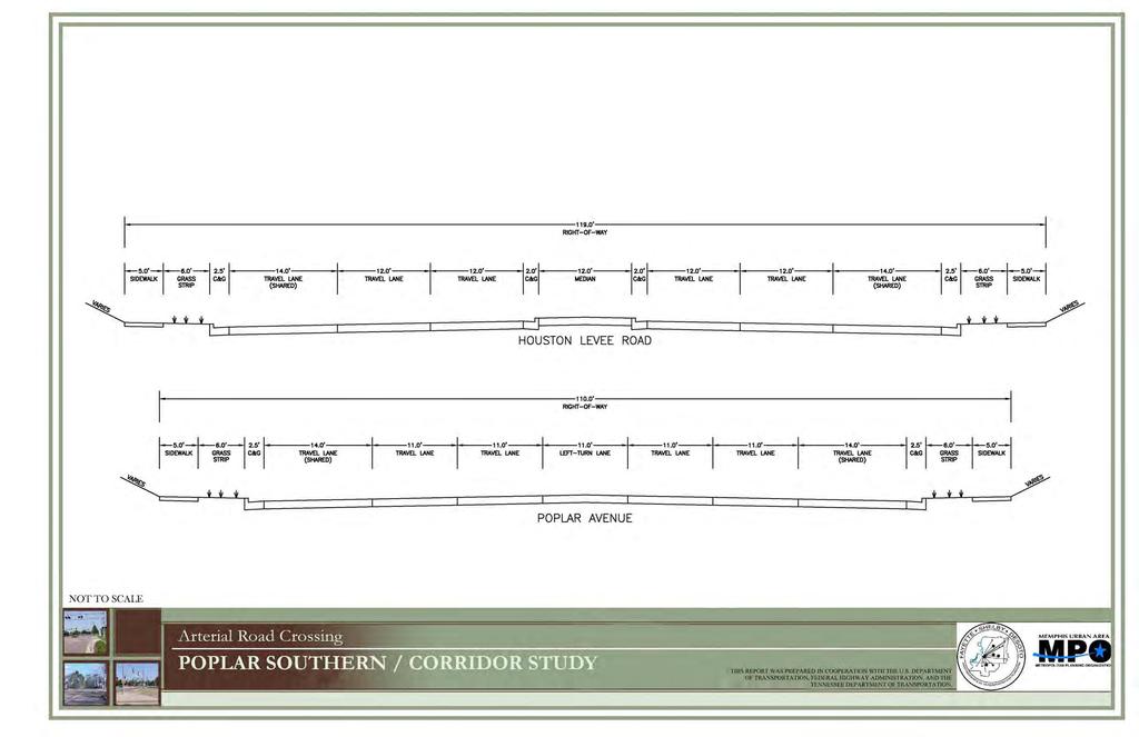
55 ROADWAYTYPICALSECTIONS FIGURE12
56 B. Construction Impacts Limits of Construction The limits of construction necessary for reconstructing the roadway, the installation of a railroad overpass bridge, and the redevelopment of the impacted adjacent properties are shown on Figure 13. For Poplar Avenue, construction would begin approximately 600 feet east of the Houston Levee Road and Poplar Avenue intersection and extend to approximately 600 feet west of the intersection. For Houston Levee Road, construction would begin approximately 525 feet north of the intersection and extend south to a point approximately 685 feet south of the intersection. 48


57 HOUSTON LEVEE ROAD LIMITS OF STUDY IMPACTS FIGURE 13 POPLAR AVE. HOUSTON LEVEE RD. LIMITS OF AREA Houston Levee Road Limits of Study Impacts The Houston Levee Road Limits of Study Impacts exhibit illustrates the area within the study limits and is approximately 25.4 acres including acreage inside and outside of the right-of-way. The limits are based on the extent of land impacted due to the grade-separated crossing improvements. Due to the extreme change in elevation of the road, Poplar Avenue and Houston Levee Road will be lowered approximately 12 feet, the land adjacent to the right-of-way will also be impacted. One of the key components to the success of a business is the visibility and accessibility of the building to the user. Therefore the approach was taken to keep the elevation of the buildings relative to the elevation of the new road. This could be accomplished by grading parcels adjacent to the roadway to an elevation relative to the new roadway elevation. The remaining parcels would be graded to take up the necessary grade change at the rear of the properties. The Limits of Area line represents the point where the proposed grade ties back into the existing grade, or a point where a retaining wall is required. NORFOLK-SOUTHERN RAILROAD Houston Levee Road Crossing Data Current Conditions Prior to Grade-Separated Crossing Improvements Traffic Volume (AADT): Current: 21,800 Future (2030): 38,400 (AADT - Annual Average Daily Traffic) 114' Right-of-Way with 4-Thru Lanes Crash Count (Motor Vehicle/Rail Vehicle): 1 (Based on FRA's Accident Report Database over a ten year period) NORTH AERIAL DATE: 2008 SCALE: N.T.S. PARCEL DATA SOURCE: SHELBY COUNTY REGISTER OF DEEDS THIS REPORT WAS PREPARED IN COOPERATION WITH THE U.S. DEPARTMENT OF TRANSPORTATION, FEDERAL HIGHWAY ADMINISTRATION, AND THE TENNESSEE DEPARTMENT OF TRANSPORTATION.
58 1. Traffic Impacts Construction of a grade-separated crossing is a major undertaking. Maintenance of traffic through the area during construction would require a detailed, multi-staged traffic control plan and lanes and/or entire streets would need to be closed to complete construction. A schematic staging plan was developed to illustrate maintenance of traffic during construction. For both crossing locations, the goal was to maintain a minimum of four lanes of traffic on Poplar Avenue throughout construction. The street closures, with their associated detours, would have an impact on traffic throughout the construction period. Business owners, their employees, and their patrons would feel the effects in lost time and revenue. Emergency responders (police, fire, and ambulance) would be impacted by the closures and would have to adjust their response routes accordingly. Mass transit would have to adjust their routes likewise. In general, any resident, business, or service located within the neighborhoods surrounding the crossing would have to make adjustments to their travel routines according to the new detour routing and the added time to navigate it during the construction period. For the intersection of Houston Levee Road and Poplar Avenue, traffic control would be expected to generally occur in two phases during construction. During Phase 1 of construction, northbound traffic on Houston Levee Road south of Poplar Avenue would be detoured to Winchester Road, Bailey Station Road, and Poplar Avenue to Houston Levee Road north of Poplar Avenue. For Phase 2, two options are available. Option 1, southbound traffic on Houston Levee Road, would require the completion of Crooked Creek Road to Bailey Station Road, as outlined in Collierville Major Road Plan, and detour traffic to Bailey Station and Winchester Roads. Option 2 would detour traffic along Frank Road, Shea Road, and Winchester Road. The alternative temporary construction detour routes for the Houston Levee Road crossing are shown in the Traffic Control Schematic Exhibit, Figure


59 HOUSTON LEVEE ROAD TRAFFIC CONTROL SCHEMATIC
60 2. Grading Impacts With the grade changes associated with a grade-separated crossing, a conceptual grading plan was developed to determine the impacts to the adjacent property. One of the key components to the success of a business is the visibility and accessibility of the building to the user. Therefore the approach was taken to keep the elevation of the buildings relative to the elevation of the new road. This could be accomplished by grading parcels adjacent to the roadway to an elevation relative to the new roadway elevation. The remaining parcels would be graded as to take up the necessary grade change at the rear of the properties. The limits of redevelopment line represents the point at which proposed grading ties to the existing topography or at which point a retaining wall is required. 3. Utility Impacts Utility locations for the Poplar Avenue at Houston Levee Road crossing were obtained from MLG&W and the Town of Collierville. Gas and electric facility locations were provided by MLG&W, while water and sewer locations were provided by the Town of Collierville. There were no major electrical transmission towers or gas pipelines identified and utility impacts were limited to local service lines, three phase electrical transmission lines, gas mains, and water mains. 4. Stormwater Management One concern of the grade separation was the improvements required for adequate stormwater drainage. As a result of lowering the roadways, storm drainage would need to be modified based on the new roadway elevations. The drainage for Houston Levee Road would require modifying the existing storm sewer, but it is not anticipated that a pump station would be required. This roadway would not be lowered as much as Mendenhall Road and therefore would require fewer modifications to the existing drainage system. The natural drainage basin would be modified with the improvements. Generally, the ridge separating the Wolf River and Nonconnah Creek drainage basins follows the Poplar Avenue and the Norfolk Southern Railroad. With construction of a grade separation at Houston Levee Road, approximately two acres of drainage would be moved from the Nonconnah Creek basin and added to the Wolf River basin. 52
61 C. Neighborhood Impacts 1. Business and Community Impacts It is essential that the finished floor elevations of the businesses along Houston Levee Road and Poplar Avenue relate to the new elevations of those roadways. The businesses closest to the intersection would be approximately 12 feet lower than their current elevation. The limits of redevelopment define those parcels that would be affected by the change in elevation required under Option B. During the construction and redevelopment period several businesses would have to be relocated (at least temporarily). The Houston Levee Area Map (Figure 15) illustrates the existing zoning of the parcels within the limits of the redevelopment area that would be affected by the construction. The figures indicate which businesses would be removed and which would be maintained yet impacted due to the grade-separated crossing improvements specific to each intersection. The businesses impacted and/or removed by improvements to the railroad are highlighted and summarized below. Retail 47,207 SF +/- Removed (4 Businesses) 46,516 SF +/- Impacted* (17 Businesses) Office 3,536 SF +/- Removed (1 Office) 9,434 SF +/- Impacted (3 Offices) * Impacted businesses or offices are those that would not be removed due to construction of the grade-separated crossing, but would be impacted by construction due to loss of business, construction impacts, or delays. 53

 H 1.56 AC. PUD Ballard PD - Retail Outparcel (Vacant) Lifetime Fitness Landers Ford Shops at Houston Levee 1. Children's Dental Care 2. Family Dentistry 3.")
62 PARCEL ID ACREAGE ZONING BUSINESSES A AC. R-1 Ridgeway Country Club B 2.87 AC. GC 1. Bangkok Alley Country 2. Pella Windows & Doors Club 3. Beauty Supply Collections 4. Richard & Co. Salon 5. Kathy's Nails 6. Century 21 I 9.84 AC. PUD J 9.3 AC. GC K 2.55 AC. GC L 1.8 AC. GC 7. Chiropractic Memphis 8. Superstore Exercise Equipment 9. At's-A-Pizza C 2.88 AC. GC 1. Huey's The 2. Sekisui Collection M of Houston Levee 10.Tadporter's Custom Framing 3. Comcast 4. Super Suppers 5. American Family Dentistry 6. Salon De Carlo G 1.11 AC. PUD Ballard PD - Retail Outparcel (Vacant) H 1.56 AC. PUD Ballard PD - Retail Outparcel (Vacant) Lifetime Fitness Landers Ford Shops at Houston Levee 1. Children's Dental Care 2. Family Dentistry 3. Collierville Pediatrics 0.61 AC. GC Sloane's 1. All Creatures Pet Hospital 2. State Farm Square 3. Collierville Saddlery 4. La Perla Tapatia BLDG S.F. / UNITS 24,480+/- (total) 7. Three Dog Bakery 8. All American Swim 27,544 +/- 9. Poplar Wine & Spirits (total) D 0.83 AC. GC Independent Bank 3,536 +/- E 4.91 AC. GC Christian Heritage Church 17,175 +/- F 1.57 AC. PUD Ballard PD - Retail Outparcel (Vacant) 35,670+/- 9,679 +/- (total) 9,840 +/- (total) HOUSTON LEVEE AREA MAP FIGURE 15 AH WINCHESTER RD. SCALE: 1"=500' ORIGINAL SHEET SIZE: 11X17 R-1 A LIMITS OF AREA POPLAR AVE. SCC SCC SCC GC HOUSTON LEVEE RD. ZONING LEGEND - Town of Collierville Zoning Map (Updated ) GC MPO SCC General Commercial Medical Professional Office Shopping Center Commercial B AG U PUD R-1 R-2 E C X D R S T V W AC AD Y Z AB SCC G F H J AA Planned Unit Development (Overlay) Low Density Residential Medium Density Residential I GC NORFOLK-SOUTHERN RAILROAD R-3 PUD K M N O AE R-3 L GC BUSINESSES REMOVED R-1 BUSINESSES IMPACTED P AF R-2 MPO Q R-3 NORTH R-3 High Density Residential PARCEL ID ACREAGE ZONING BUSINESSES N 1.63 AC. GC 1. The Flower Co. Sloane's 2. Dr. Ted S.Cooper Square Optometry O 8.85 AC. GC P 1.77 AC. GC Q R 1.77 AC. SCC S 0.80 AC. SCC T 1.35 AC. SCC U 3.55 AC. SCC V 1.92 AC. SCC 3. Bogie's Delicatessen 4. Natural Potential Chiropractic 5. Avis Extra Space Storage AC. GC Criss-Cross Village PD Longhorn Steakhouse Starbucks First State Bank Gallina Centro PD 1. Gilland Orthondontics 2. Tinder Box 3. T-Mobile 4. Hollywood Feed 5. Smoothie King 6. State Farm W 1.16 AC. SCC McDonald's X 2.02 AC. SCC Walgreens Y 1.37 AC. SCC Vacant Lot Z 0.84 AC. SCC Backyard Burger AA 6.26 AC. R-3 Houston Levee Galleria AB 1.51 AC. SCC First Citizens National Bank AC 1.95 AC. SCC 1. Cellular South AD AE AF AG AH 1. Enterprise Rent-A-Car 2. Shell Gas / Food Mart 2. Steak Escape 3. Cleaners 4. Prime Urgent Medical Cleaner 5. Newk's 1.67 AC. SCC Bancorp South Bank 5.22 AC. R-3 Ironwood PD AC. R-1 Parr, Elizabeth Trust 4.67 AC. SCC Gallina Centro PD 5.58 AC. SCC Gallina Centro PD BLDG S.F. / UNITS 14,495 +/- (total) 76,645 +/- 10,842 +/- (total) 6,190 +/- 1,779 +/- 3,926 +/- 17,774 +/- (total) 4,247 +/- 15,044 +/- 3,568 +/- 6,028 +/- 11,269 +/- (total) 4,674 +/- SOURCE: SHELBY COUNTY REGISTER OF DEEDS THIS REPORT WAS PREPARED IN COOPERATION WITH THE U.S. DEPARTMENT OF TRANSPORTATION, FEDERAL HIGHWAY ADMINISTRATION, AND THE TENNESSEE DEPARTMENT OF TRANSPORTATION.
63 D. Post Construction Community Impacts 1. General Neighborhood Impacts Construction of the selected alternatives would have an impact on the surrounding neighborhood after the construction period. One notable impact is the loss of current businesses. While new construction has the potential to attract businesses, there is the possibility that businesses closed during the construction period would either relocate or would remain closed. Another impact is the increase in traffic that would result from a grade-separated crossing. The potential of getting caught by a train at non-grade separated crossings would cause many drivers to select routes that include the separation. This is especially significant at rush hour where commuters, seeking to save time, may find a heavily congested intersection and a resulting delay. 2. Impacts to Safety It is anticipated that the safety of the crossing would be improved with construction of the selected alternative. By providing a grade separation, vehicles traveling along Houston Levee Road would not cross the rail line at-grade and conflict points associated with the rail crossing would be eliminated, removing the potential for a vehicle/rail crash. Over a ten-year period from 1999 to 2008, there was one documented case of a rail/highway vehicle crash at the Houston Levee Road crossing. 3. Impacts to Congestion Construction of the selected alternatives would reduce congestion at the intersection. By eliminating the at-grade crossing at Houston Levee Road, the route would remain open as trains pass through the area. This would reduce non-recurring delay by allowing vehicles to cycle through the intersection as trains pass through the area. It is estimated that as many as 20 trains per day would use the rail line in the horizon year of It is also estimated that vehicles encountering a train would experience a three-minute delay on average. Using these estimates and the anticipated number of vehicles using the crossings in the horizon year, approximately 65 to 70 hours of delay per day would be eliminated with a grade separation. 4. Environmental Impacts The environmental impacts of constructing the improvements at the Houston Levee Road crossing were reviewed. The environmental issues identified within the study boundaries included impacts to floodplains, rare species habitat, ecological 55
64 sites, superfund sites, hazardous waste generators, toxic chemical release sites, air release sites, and water discharge sites. Sites within a ¼ mile radius of the study intersections were noted. The intersection of Poplar Avenue at Houston Levee Road was found to have no environmental issues. There would be positive impacts to air quality provided by the grade separation due to reductions in vehicles delayed and idling as vehicles would no longer be delayed or stopped by railroad activity. 5. Regional and Local Economic Impacts The REMI (Regional Economic Models, Inc) model, an advanced economic impact modeling software, was used to estimate the total direct, indirect, and induced impacts of the construction of the Houston Levee Road grade separation. There are two major categories of impacts: One-time impacts, which result from the construction of the improvements occurring once during the construction period. Ongoing impacts, which result from increased quality of life, personal income, and labor productivity created by the travel time savings. Both types of impacts have been evaluated in this report, and the results are highlighted as follows: Construction impacts - These impacts are estimated to occur evenly during construction, and would not recur after the construction period is over. It is estimated that the construction of the underpass would result in the creation of 358 jobs and create a total $42.1 million increase in output to firms in Shelby County. Ongoing impacts The travel time savings created by the two grade separations would result in an increase of $3.0 million in output (in 2010 constant dollars) and an associated additional 13 jobs in 2020 within Shelby County on an annual basis. By 2030, the increase in personal income in the region, in 2030 dollars, is estimated to reach close to $2.4 million. These impacts recur year after year. 6. Impacts to Transit Construction would have a minor impact to adjacent transit routes and for the intersection of Poplar Avenue at Houston Levee Road. This intersection has only one bus route that travels along Poplar Avenue and does not cross the rail line. 56
65 7. Bicycle Lanes The rail crossing at Houston Levee Road was investigated to determine if bicycle lanes would be required based on recommendations in the 2030 Long Range Transportation Plan (LRTP). For the intersection of Poplar Avenue at Houston Levee, wide outside lanes are recommended and these improvements are included in the proposed typical section. 8. Minor Crossings and Street Closures The intersection of Poplar Avenue at Houston Levee Road is not expected to have any streets that would require closure with construction of the selected alternative. E. Horizontal and Vertical Rail Geometry Improvements to the horizontal and vertical geometry for the rail line were established using Norfolk Southern s design criteria. To minimize the impact to the rail line, horizontal geometry was not modified for either crossing. The design criteria used for this study can be found in Appendix D. F. Limits of Redevelopment The Houston Levee Road Limits of Study Impacts exhibit illustrates the area within the study limits that would be impacted by the railroad and roadway improvements made for a grade-separated crossing. As discussed previously in Section VI.B.2, due to the change in elevation of the roads, the land adjacent to the right-of-way would be significantly impacted. G. Conceptual Redevelopment Plan 1. Approach Changes to the existing roadway elevations, due to the construction of the grade-separated crossing, requires the redevelopment of the area surrounding these crossings. Consistent with the Town of Collierville, redevelopment of these parcels would likely result in the property being developed with more density and with a mixed-use approach. The existing uses on the northwest, southwest, and southeast quadrants of the intersection of Houston Levee Road and Poplar Avenue consists of one-story retail out parcels and shopping center and it is recommended to maintain this existing development pattern at this intersection. For the car dealership parcel in the northeast quadrant of the intersection, higher 57
66 potential use may be appropriate. To add density and variety, a mixed-use approach was taken that would include Multi-level Office (two-story) and Retail (one-story). The mixed-use concept for this area would add an additional 38,464 SF of office space and 12,793 SF of retail space. A parking analysis was performed which maximized the building square footage while providing adequate surface parking. The construction of the grade-separated crossings would likely block the views of businesses on the opposite side of the railroad track. Presently, drivers at Houston Levee Road and Poplar Avenue can easily see businesses on the south side of the tracks from Poplar Avenue. With the construction of a grade separation at this location, those views would be blocked causing a negative impact to the existing retail centers. In an effort to open the views at this intersection, the proposed improvements increased the bridge span for the railroad crossing from 170 feet to 340 feet. The following exhibit, Figure 16, illustrates the Conceptual Redevelopment Plan for the Houston Levee Road crossing. Also included is a Conceptual Redevelopment Plan Products chart, Figure 17, listing the proposed and existing land use products. While the Conceptual Redevelopment Plan illustrates the specific crossing, the design principles are representative and can be used for other crossings along the corridor to create a redevelopment plan specific to other intersections. The Conceptual Redevelopment Plan reflects only one possible scenario and should not be considered the only option for redevelopment. 58


67 HOUSTON LEVEE REDEVELOPMENT CONCEPT HOUSTON LEVEE CONCEPTUAL REDEVELOPMENT PLAN BALLARD PROPERTY PUD RIDGEWAY COUNTRY CLUB R-1 +0 RETENTION POND COUNTRY CLUB COLLECTIONS G-C EX. RETAIL SHOPS AT HOUSTON LEVEE G-C 2-STORY OFFICE 2-STORY OFFICE BALLARD PROPERTY PUD LIMITS OF AREA PO PL AR AV 2-STORY OFFICE E RETAIL GALLINA CENTRO PD RAILROAD BRIDGE 41+0 EX. TREE GALLINA CENTRO PD GALLINA CENTRO PD HOUSTON LEVEE RD. 28 CHRISTIAN HERITAGE CHURCH G-C FIGURE 16 SLOANES SQUARE G-C NO RFO LK -SO UT HE RN RA ILR OA D CONCEPTUAL MASTER PLAN USES 00 MULTI-LEVEL OFFICE 2-STORY HOUSTON LEVEE GALLERIA R-3 RETAIL 1-STORY PARR, ELIZABETH TRUST R-1 NORTH SCALE: N.T.S. THIS REPORT WAS PREPARED IN COOPERATION WITH THE U.S. DEPARTMENT OF TRANSPORTATION, FEDERAL HIGHWAY ADMINISTRATION, AND THE TENNESSEE DEPARTMENT OF TRANSPORTATION.
68
69 2. Conceptual Redevelopment Plan Imaging Following is a series of redevelopment plan imaging exhibits, Figures 18-21, illustrating the mixed-use redevelopment approach taken at the Mendenhall Road crossing. The redevelopment plan imaging exhibits are based on the Conceptual Redevelopment Plan. These illustrations reflect only one of many possible scenarios for development of the area. 61


70 HOUSTON LEVEE CONCEPTUAL REDEVELOPMENT IMAGING FIGURE 18 Poplar Avenue POPLAR AVE HOUSTON LEVEE RD Limits of Study Impacts Houston Levee Road POPLAR AVE HOUSTON LEVEE RD A SketchUp rendering of the Conceptual Redevelopment Plan for the intersection of Houston Levee Road and Poplar Avenue. The plan maintains retail uses in the northwest, southwest, and southeast quadrants, while introducing a mixed-use component consisting of multi-level office and retail to the northeast quadrant. Conceptual Redevelopment Plan NORTH THIS REPORT WAS PREPARED IN COOPERATION WITH THE U.S. DEPARTMENT OF TRANSPORTATION, FEDERAL HIGHWAY ADMINISTRATION, AND THE TENNESSEE DEPARTMENT OF TRANSPORTATION.


71 HOUSTON LEVEE CONCEPTUAL REDEVELOPMENT IMAGING FIGURE 19 Poplar Ave. VIEW A: Conceptual bird's eye view looking northwest across the railroad bridge. Existing retail stores remain with modifications and redevelopment of existing outparcel. D POPLAR AVE HOUSTON LEVEE RD C VIEW B: Conceptual bird's eye view looking at the northeast quadrant. Mixed-use concept includes retail fronting Houston Levee and Poplar with multi-level office behind. B A NORTH VIEW C: Conceptual bird's eye view looking southwest across railroad bridge. An improved right-of-way is illustrated with sidewalks, medians, shared drive lanes, and street trees. VIEW D: Conceptual bird's eye view looking south across the railroad bridge. Increased bridge spans opens the views from the north and south sides of Poplar. THIS REPORT WAS PREPARED IN COOPERATION WITH THE U.S. DEPARTMENT OF TRANSPORTATION, FEDERAL HIGHWAY ADMINISTRATION, AND THE TENNESSEE DEPARTMENT OF TRANSPORTATION.


72 POPLAR AVE HOUSTON LEVEE INTERSECTION CONCEPTUAL BEFORE AND AFTER IMAGING HOUSTON LEVEE RD NORFOLK SOUTHERN RAILROAD FIGURE 20 A NORTH VIEW A BEFORE: Existing view of the northeast corner of Houston Levee and Poplar. The railroad is at-grade with improved signalization. SCALE: N.T.S. VIEW A AFTER: Conceptual view of the northeast corner of Houston Levee and Poplar. The railroad is raised fifteen feet from its current location and Houston Levee and Poplar are lowered twelve feet. A mixed-use plan is introduced with retail and multi-level office. VIEW A AFTER: Conceptual bird's eye view of the northeast corner of Houston Levee and Poplar. THIS REPORT WAS PREPARED IN COOPERATION WITH THE U.S. DEPARTMENT OF TRANSPORTATION, FEDERAL HIGHWAY ADMINISTRATION, AND THE TENNESSEE DEPARTMENT OF TRANSPORTATION.


73 POPLAR AVE HOUSTON LEVEE INTERSECTION CONCEPTUAL BEFORE AND AFTER IMAGING HOUSTON LEVEE RD NORFOLK SOUTHERN RAILROAD B FIGURE 21 VIEW B BEFORE: Existing view at the southwest corner of Houston Levee and Poplar. The railroad is at-grade with improved signalization. SCALE: N.T.S. NORTH VIEW B AFTER: Conceptual view of the southwest corner of Houston Levee and Poplar. On the south side of Poplar one-story retail outparcels are reintroduced. VIEW B AFTER: Conceptual bird's eye view of the southwest corner of Houston Levee and Poplar looking across the railroad bridge. The columns supporting the railroad bridge are spaced further apart to provide views from both sides of the intersection. THIS REPORT WAS PREPARED IN COOPERATION WITH THE U.S. DEPARTMENT OF TRANSPORTATION, FEDERAL HIGHWAY ADMINISTRATION, AND THE TENNESSEE DEPARTMENT OF TRANSPORTATION.
Goals for Tonight s Meeting
 South Anthony Boulevard Railroad Grade Separation Study Report to Community November 30, 2011 Andorfer Commons Theatre Indiana Tech University Goals for Tonight s Meeting Recap of the meeting from last
The transportation system in a community is an
 7 TRANSPORTATION The transportation system in a community is an important factor contributing to the quality of life of the residents. Without a sound transportation system to bring both goods and patrons
Mitchell Ranch South MPUD Application for Master Planned Unit Development Approval Project Narrative. Introduction
 Mitchell Ranch South MPUD Application for Master Planned Unit Development Approval Project Narrative Introduction Mitchell Ranch South is a proposed single family (detached) residential development on
Proposed Comprehensive Plan Strategies DRAFT for discussion June 28, 2017
 Proposed Comprehensive Plan Strategies DRAFT for discussion June 28, 2017 Land Use Rural Areas Refine the Farm and Forest area (FF) Update FF boundaries to account for existing lots less than five acres
I. DESCRIPTION OF PROPOSED ACTION... 1 A. General Description... 1 B. Historical Resume and Project Status... 2 C. Cost Estimates...
 PROJECT COMMITMENTS SUMMARY... S-1 1. Type of Action... S-1 2. Description of Action... S-1 3. Summary of Purpose and Need... S-1 4. Alternatives Considered... S-2 5. NCDOT Alternatives Carried Forward...
BeltLine Corridor Environmental Study
 BeltLine Corridor Environmental Study Citywide Conversation on Transit and Trails April 2, 2009 Agenda & Introductions Introductions Environmental Study Process Overview of the BeltLine Project BeltLine
BeltLine Corridor Environmental Study
 BeltLine Corridor Environmental Study Joint TAC and SAC Meeting December 8, 2008 What We Will Discuss Today Outreach and Agency Coordination Scoping Results Existing Conditions Historical and Archeological
PREPARED FOR: PLATTEVIEW ROAD CORRIDOR STUDY EXECUTIVE SUMMARY
 PREPARED FOR: PLATTEVIEW ROAD CORRIDOR STUDY EXECUTIVE SUMMARY SEPTEMBER 2016 Introduction The Platteview Road Corridor Study was led by the Metropolitan Area Planning Agency (MAPA) with assistance from
CHAPTER 7: Transportation, Mobility and Circulation
 AGLE AREA COMMUNITY Plan CHAPTER 7 CHAPTER 7: Transportation, Mobility and Circulation Transportation, Mobility and Circulation The purpose of the Transportation, Mobility and Circulation Chapter is to
PROJECT BACKGROUND. Preliminary Design Scope and Tasks
 PROJECT BACKGROUND Preliminary Design Scope and Tasks The purpose of this Study is the development of preliminary designs for intersection improvements for Trunk Highway (TH) 36 at the intersections of
The Illinois Department of Transportation and Lake County Division of Transportation. Route 173, including the Millburn Bypass
 The Illinois Department of Transportation and Lake County Division of Transportation welcome you to this Public Hearing for U.S. Route 45 from Illinois Route 132 to Illinois Route 173, including the Millburn
Gold Line Bus Rapid Transit Transit Oriented Development (BRTOD) Helmo Station Area Plan
 Helmo Station Area Plan") Appendix F Gold Line Bus Rapid Transit Transit Oriented Development (BRTOD) Helmo Station Area Plan Introduction and Purpose of the Plan The Gold Line Bus Rapid Transit facility is an eleven-mile dedicated
Appendix F Gold Line Bus Rapid Transit Transit Oriented Development (BRTOD) Helmo Station Area Plan Introduction and Purpose of the Plan The Gold Line Bus Rapid Transit facility is an eleven-mile dedicated
ALTERNATIVES. NCDOT made an early decision to first determine how to build the project (construction method) followed by what to build (alternatives).
 followed by what to build (alternatives).") III. ALTERNATIVES A. CONSTRUCTION METHOD ALTERNATIVES NCDOT made an early decision to first determine how to build the project (construction method) followed by what to build (alternatives). One of the
III. ALTERNATIVES A. CONSTRUCTION METHOD ALTERNATIVES NCDOT made an early decision to first determine how to build the project (construction method) followed by what to build (alternatives). One of the
ROAD CLOSURE AND LAND USE AMENDMENT SILVER SPRINGS (WARD 1) NORTHEAST OF NOSEHILL DRIVE NW AND SILVER SPRINGS ROAD NW BYLAWS 2C2018 AND 29D2018
 NORTHEAST OF NOSEHILL DRIVE NW AND SILVER SPRINGS ROAD NW BYLAWS 2C2018 AND 29D2018") Page 1 of 19 EXECUTIVE SUMMARY This application proposes redesignating two parcels in the community of Silver Springs from Special Purpose Future Urban Development (S-FUD) District and undesignated road
Page 1 of 19 EXECUTIVE SUMMARY This application proposes redesignating two parcels in the community of Silver Springs from Special Purpose Future Urban Development (S-FUD) District and undesignated road
NORTH-SOUTH CORRIDOR STUDY EXECUTIVE SUMMARY. Executive Summary
 Executive Summary Background As congestion continues to affect mobility in the region, the Ozarks Transportation Organization (OTO) is particularly concerned with traffic movement. The North-South Corridor
Cumberland Comprehensive Plan Town Council adopted August 2003, State adopted June 2004 TABLE OF CONTENTS
 TABLE OF CONTENTS I. Executive Summary A. Scope of the Comprehensive Plan I-2 B. Plan Development Process I-3 C. Plan Format I-3 D. Acknowledgements I-4 II. Demographic Analysis A. Introduction II-1 B.
ITS Concept Development Activity Descriptions
 ITS Concept Development Activity Descriptions October 2015 Procedures are subject to change without notice. Check the NJDOT website to ensure this is the current version. Table of Contents Concept Development
2. AGENCY COORDINATION AND PUBLIC INVOLVMENT
 2. AGENCY COORDINATION AND PUBLIC INVOLVMENT This chapter discusses the process carried out for conducting agency coordination and public involvement activities. TECHNICAL ADVISORY COMMITTEE A Technical
City of Loveland Public Information Meeting February 19, 2009
 Railroad Quiet Zones City of Loveland Public Information Meeting February 19, 2009 Railroad Quiet Zones AGENDA: 7:00-7:05 Introduction Frank Hempen (City Project Manager) 7:05-7:20 Railroad Quiet Zones
This Review Is Divided Into Two Phases:
 Semiahmoo Town Centre Review The purpose of this review: To review the Semiahmoo Town Centre Concept Plan, originally approved in 1993, to ensure that this centre will continue to serve the needs of South
SECTION 4(f) DE MINIMIS DOCUMENTATION
 DE MINIMIS DOCUMENTATION") SECTION 4(f) DE MINIMIS DOCUMENTATION Illinois Route 60/83 IL 176 to the intersection of IL 60 (Townline Road) Lake County P-91-084-07 Mundelein Park and Recreation District Project Limit SECTION 4(f)
SECTION 4(f) DE MINIMIS DOCUMENTATION Illinois Route 60/83 IL 176 to the intersection of IL 60 (Townline Road) Lake County P-91-084-07 Mundelein Park and Recreation District Project Limit SECTION 4(f)
ARGENTA TRAIL (CSAH 28/63) REALIGNMENT SOUTH PROJECT (CP 63-25)
 REALIGNMENT SOUTH PROJECT (CP 63-25)") ARGENTA TRAIL (CSAH 28/63) REALIGNMENT SOUTH PROJECT (CP 63-25) Preliminary Design Report February 2015 Prepared For: City of Inver Grove Heights Dakota County Prepared By: Kimley-Horn and Associates,
ARGENTA TRAIL (CSAH 28/63) REALIGNMENT SOUTH PROJECT (CP 63-25) Preliminary Design Report February 2015 Prepared For: City of Inver Grove Heights Dakota County Prepared By: Kimley-Horn and Associates,
495/MetroWest Development Compact Plan Citizen Planner Training Collaborative Conference. March 17, 2012
 495/MetroWest Development Compact Plan Citizen Planner Training Collaborative Conference March 17, 2012 Project Process Local and Regional Priority Areas Growth Scenarios Transportation Investment Categories
Knoxville Area Transit (KAT) Transit Development Plan Corridor Analysis
 Transit Development Plan Corridor Analysis") Knoxville Area Transit (KAT) Transit Development Plan Submitted to: Knoxville-Knox County Metropolitan Planning Commission Submitted by: PB Americas, Inc. Under contract to: The Corradino Group, Inc. October
Knoxville Area Transit (KAT) Transit Development Plan Submitted to: Knoxville-Knox County Metropolitan Planning Commission Submitted by: PB Americas, Inc. Under contract to: The Corradino Group, Inc. October
2017 General Obligation Bond
 2017 General Obligation Bond Presentation of Public and Council Projects to the Transportation & Mobility Stakeholder Committee April 13, 2017 Agenda Deferred Maintenance Project Development Process Projects
Pennsy Greenway Trail
 Town of Schererville Pennsy Greenway Trail DES. #s: 0401062, 1173595 & 1382661 Construction of Pennsy Greenway Trail beginning at Wilhelm Street and continuing northwest along the former Penn Central railroad
4-Town Comprehensive Plan DRAFT 7/30/07
 4-Town Comprehensive Plan DRAFT 7/30/07 Acknowledgements ning Committee Town of Harrisburg Norman Roof Randy Nicol Town of Martinsburg Terry Thisse Paul Kelly Town of Montague Jan Bagdanowicz Wendy Perry
Public Hearing. Charlotte County-Punta Gorda MPO - Meeting Rooms A and B March 14, open house at 4 p.m., formal presentation at 5 p.m.
 Public Hearing Charlotte County-Punta Gorda MPO - Meeting Rooms A and B March 14, 2019 open house at 4 p.m., formal presentation at 5 p.m. Welcome to the Public Hearing for the Harborview Road (CR 776)
Planning Districts INTRODUCTION
 INTRODUCTION To facilitate detailed examination of development prospects for all areas of the community, Delano has been divided into 14 planning districts. The location of these planning districts is
Land Use Amendment in Southwood (Ward 11) at and Elbow Drive SW, LOC
 at and Elbow Drive SW, LOC") 2018 November 15 Page 1 of 10 EXECUTIVE SUMMARY This land use amendment application was submitted by Rick Balbi Architect on 2017 August 31 on behalf of Sable Developments Ltd, and with authorization from
2018 November 15 Page 1 of 10 EXECUTIVE SUMMARY This land use amendment application was submitted by Rick Balbi Architect on 2017 August 31 on behalf of Sable Developments Ltd, and with authorization from
COLVER ROAD INDUSTRIAL CONCEPT PLAN
 COLVER ROAD INDUSTRIAL CONCEPT PLAN A CONCEPTUAL LAND USE AND TRANSPORTATION PLAN FOR TA-4 AN URBAN RESERVE AREA OF THE CITY TALENT City of Talent Adopted by City Council Resolution No., June, 2015 PART
City of Hermosa Beach Administrative Policy #
 City of Hermosa Beach Administrative Policy # SUBJECT: Living Streets Policy Date: Approved by: City Council Authority: Public Works Department & Community Development Department Mayor, PURPOSE The City
Right-of-Way Acquisitions and Relocations Technical Memorandum
 Right-of-Way Acquisitions and Relocations Technical Memorandum Southeast Extension Project Lincoln Station to RidgeGate Parkway Prepared for: Federal Transit Administration Prepared by: Denver Regional
City of Toronto. Emery Village Transportation Master Plan
 City of Toronto Emery Village Transportation Master Plan May 2009 Emery Village Transportation Master Plan Toronto, ON May 2009 Consulting Inc. 100 York Blvd., Suite 300 Richmond Hill, ON L4B 1J8 Tel:
WELCOME TO OPEN HOUSE TWO November 28, 2018
 Langstaff Road Weston Road to Highway 7 Class Environmental Assessment Study WELCOME TO OPEN HOUSE TWO November 28, 2018 Please sign in and join our mailing list Study Overview York Region is conducting
University Parkway Corridor Plan. Public Workshop Sept. 18, 2017
 University Parkway Corridor Plan Public Workshop Sept. 18, 2017 AGENDA 1. Overview of Process 2. Study Area 3. Components of the Plan 4. What We Know 5. What We Have Heard 6. Tonight s Input 7. Next Steps
Southeast Extension to RidgeGate Parkway Scoping Booklet
 Southeast Extension to RidgeGate Parkway Scoping Booklet PUBLIC SCOPING MEETING SCHEDULE Public Scoping Meeting Wednesday, November 2, 2011 6:00pm to 7:30pm City of Lone Tree Recreation Center Willow Room
1.0 Introduction. Purpose and Basis for Updating the TMP. Introduction 1
 1.0 Introduction The Town of Castle Rock is situated between the metropolitan areas of Denver and Colorado Springs, amidst a unique terrain of rolling hills, mesas, ravines, and waterways. Like many Front
SHEFFIELD PARK Paulding County, GA DRI #588
 SHEFFIELD PARK Paulding County, GA DRI #588 Supplemental Information for RDC s DRI (Form 2) Review August 16, 2004 Prepared for: Mr. David Howerin Coosa Valley RDC 1 Jackson Hill Drive Rome, GA 30161 P.O.
12/9/2013. HOLLYWOOD/PINES CORRIDOR PROJECT AMPO 2013 Annual Conference October 24, Our Perspective. Broward.
 HOLLYWOOD/PINES CORRIDOR PROJECT AMPO 2013 Annual Conference October 24, 2013 Our Perspective Broward Fort Lauderdale 1 Broward Metropolitan Planning Organization Fort Lauderdale Fort Lauderdale Skyline
PROJECT STATEMENT LOCATION/DESIGN PUBLIC HEARING. 19 th AVENUE NORTH EXTENSION PROJECT FROM SPRINGDALE DRIVE TO NORTH 2 ND STREET/U.S.
 PROJECT STATEMENT LOCATION/DESIGN PUBLIC HEARING 19 th AVENUE NORTH EXTENSION PROJECT FROM SPRINGDALE DRIVE TO NORTH 2 ND STREET/U.S. 67 HEARING LOCATION: ERICKSEN COMMUNITY CENTER 1401 11 TH AVENUE NORTH
112th Avenue Light Rail Options Concept Design Report JUNE 2010 PREPARED FOR PREPARED BY TBG PGH
 112th Avenue Light Rail Options Concept Design Report JUNE 2010 PREPARED FOR PREPARED BY TBG060310124909PGH C ontents Introduction 1 Project Overview 1 Public Involvement and Technical Coordination 4 Description
Subject: City of Richfield Cedar Avenue Corridor Plan Comprehensive Plan Amendment, Review File No
 Committee Report Business Item No. 2017-21 Community Development Committee For the Metropolitan Council meeting of January 25, 2017 Subject: City of Richfield Cedar Avenue Corridor Plan Comprehensive Plan
THAT the attached Terms of Reference for the Thornhill Centre Street Study be approved.
 COMMITTEE OF THE WHOLE AUGUST 18, 2003 THORNHILL CENTRE STREET STUDY PLANNING FILE: 15.92 Recommendation The Commissioner of Planning recommends: THAT the attached Terms of Reference for the Thornhill
IOWA HIGHWAY 57 / WEST 1 ST STREET STUDY PUBLIC INFORMATIONAL MEETING APRIL 22, 2014
 IOWA HIGHWAY 57 / WEST 1 ST STREET STUDY PUBLIC INFORMATIONAL MEETING APRIL 22, 2014 INTRODUCTION The City of Cedar Falls and the Iowa Department of Transportation are conducting a Public Informational
Mississippi Skyway Preliminary Engineering Report
 EXECUTIVE SUMMARY Mississippi Skyway Preliminary Engineering Report CITY OF RAMSEY, MINNESOTA DECEMBER 2014 City of RAMSEY EXECUTIVE SUMMARY Project Need and Intent The Mississippi Skyway pedestrian bridge
Preliminary Assessment of Transportation Issues Related to Proposed Casino at Gateway South
 Preliminary Assessment of Transportation Issues Related to Proposed Casino at Gateway South DRAFT - 9/16/09 This memorandum summarizes the perspective of the City of Baltimore, Department of Transportation
SH 199 Corridor Master Plan. Community Meeting No. 2 May 31, 2017
 Community Meeting No. 2 May 31, 2017 Transportation Projects On or Near SH 199 SH 199 from 0.3 miles south of FM 1886 to south end of Lake Worth bridge Construct freeway mainlanes and frontage roads 10-Year
Regarding actual construction when development occurs, the following applicable guidelines are provided to address public safety issues:
 MIAMI-DADE COUNTY DEPARTMENT OF PLANNING AND ZONING General Comments 1. COMMENT: A careful review of the application provided shows that there is likely to be an impact on the Miami-Dade Police Department
The Village of Sugar Grove, in partnership with Kane County, the Illinois Department of Transportation, and the Illinois Tollway welcomes you to the
 The Village of Sugar Grove, in partnership with Kane County, the Illinois Department of Transportation, and the Illinois Tollway welcomes you to the first Public Meeting for the proposed interchange improvement
PRELIMINARY REPORT. HIGHWAY 18 CORRIDOR NEIGHBORHOOD PLAN VILLAGE OF DOUSMAN November, 2014
 PRELIMINARY REPORT HIGHWAY 18 CORRIDOR NEIGHBORHOOD PLAN VILLAGE OF DOUSMAN November, 2014 This preliminary report presents the initial recommendations for land use within the Highway 18 corridor along
USA Addition of South & East Side Residential Parcels. USA Deletion of a Town of Christiana Parcel. Conversion from USA to Limited Service Area
 Village of Rockdale Village of Rockdale 148 Water Street Cambridge, WI 53523 Phone 608.423.1497 Fax 608.423.9694 Urban Service Area (USA) Amendment USA Addition of South & East Side Residential Parcels
Transportation Research Center
 Increasing Design Flexibility in the AASHTO Green Book Your Department Name Presentation to AASHTO Subcommittee on Design Doug Harwood, MRIGlobal July 2017 Transportation Research Center Resolution of
MORRISVILLE TRANSPORTATION PLAN TOWN COUNCIL PRESENTATION AUGUST 22, 2017
 TOWN COUNCIL PRESENTATION AUGUST 22, 2017 SCENARIO PLANNING CORRIDORS Town Hall Drive Baseline + 2 McCrimmon Parkway Baseline + 2 NC 54 Baseline + 2 7 subregion model runs determining carrying capacity
OVERMOUNTAIN VICTORY TRAIL BURKE CALDELL CORRIDOR FEASIBLITY STUDY REQUEST FOR QUALIFICATIONS CALDWELL COUNTY PATHWAYS
 OVERMOUNTAIN VICTORY TRAIL BURKE CALDELL CORRIDOR FEASIBLITY STUDY REQUEST FOR QUALIFICATIONS CALDWELL COUNTY PATHWAYS Caldwell County Pathways along with our co-partners City of Lenoir, Town of Gamewell,
The West Vaughan Employment Area Secondary Plan Policies
 Part 2: The West Vaughan Employment Area Secondary Plan Policies 2.1 General Policies It is the policy of Council: 2.1.1. That the West Vaughan Employment Area (the WVEA), identified on Schedule 1, will
Definitions. Average Daily Traffic Demand (ADT): The actual number or projected number of cars that pass a point in a 24-hour period.
: The actual number or projected number of cars that pass a point in a 24-hour period.") Definitions Access Management: A combination of physical techniques and transportation policies used to control the flow of traffic between roads and the surrounding lands. Alternative City Form Scenarios:
Definitions Access Management: A combination of physical techniques and transportation policies used to control the flow of traffic between roads and the surrounding lands. Alternative City Form Scenarios:
The GATEWAYS Sub Area Master Plan. City of Walker
 The GATEWAYS Sub Area Master Plan City of Walker Introduction: The Walker City Commission and Planning Commission decided in 2011 to create a sub-area master plan for the Remembrance Road and Wilson Avenue
WHAT IS THE PURPOSE OF THE OPEN HOUSE?
 WHAT IS THE PURPOSE OF THE OPEN HOUSE? OPEN HOUSE PURPOSE The purpose of the open house is to provide an update on the study process and introduce the preliminary concept alternatives. The open house provides
STATE OF TENNESSEE DEPARTMENT OF TRANSPORTATION ENVIRONMENTAL DIVISION
 STATE OF TENNESSEE DEPARTMENT OF TRANSPORTATION ENVIRONMENTAL DIVISION Suite 900 - James K. Polk Building 505 Deaderick Street Nashville, Tennessee 37243-0334 MEMORANDUM TO: FROM: Files Joe W. Matlock,
State Highway 121 Southwest Parkway. Fort Worth s Transportation Success Story in Design and Cooperation
 State Highway 121 Southwest Parkway Fort Worth s Transportation Success Story in Design and Cooperation Greater Fort Worth Association of Realtors October 24, 2007 Presented by: Dan Lamers, P.E. North
KEIZER STATION PLAN INTRODUCTION
 KEIZER STATION PLAN INTRODUCTION Planning for this area began in 1987 when the Keizer Comprehensive Plan established the Chemawa Activity Center and McNary Activity Center. The first Chemawa Activity Center
DRAFT Subject to Modifications
 TREASURE COAST REGIONAL PLANNING COUNCIL M E M O R A N D U M To: Council Members AGENDA ITEM 8 From: Date: Subject: Staff May 19, 2017 Council Meeting Florida Department of Transportation Complete Streets
Making Transit Oriented Development Work For Boonton, NJ
 Making Transit Oriented Development Work For Boonton, NJ Bloustein School of Planning and Public Policy Studio Dan Burton Loannie Dao Webster Slater Brandon Williams Ian Watson Maria Laham Nicola Mammes
Final Master Plan and Development Control Regulations
 1. INTRODUCTION CHECK LIST a. Introduction b. Table of contents c. Definitions. d. scope of works. 2. FINAL OVERALL MASTER PLAN a. SITE ANALYSIS and OVERVIEW: i. Existing and Proposed Site Plan Levels.
Ten Mile Creek Planning Area
 PLANNING AREA POLICIES TEN MILE CREEK Ten Mile Creek Planning Area Location and Context The Ten Mile Creek Planning Area ( Ten Mile Creek area ) is located south of the current Boise AOCI, generally south
Institutional Master Plan The Arnold Arboretum of Harvard University
 Institutional Master Plan The Arnold Arboretum of Harvard University Submitted to: Boston Redevelopment Authority One City Hall Square Boston, MA 02201 Submitted by: The Arnold Arboretum of Harvard University
Citizen Comment Staff Response Staff Recommended Revision Planning Committee
 Citizen Comment Staff Response Staff Recommended Revision Planning Committee Area No. 1: Owner desires retail land uses. Area No. 1a: Owner of two small parcels adjacent to Area No. 1 desires retail land
1.0 INTRODUCTION 1.1 TH 14 WEST STUDY AREA Project Description Functional Classification Purpose of the Project
 1.0 INTRODUCTION 1.1 TH 14 WEST STUDY AREA 1.1.1 Project Description The Trunk Highway (TH) 14 West Corridor is a two-lane roadway approximately 22 miles in length. Located in Nicollet County, the corridor
Illustration of Eastlake Farmer s Cooperative Grain Elevator. Chapter 5: implementation 5-1
 Illustration of Eastlake Farmer s Cooperative Grain Elevator Chapter 5: implementation 5-1 chapter 5: implementation Introduction The Eastlake Subarea Plan includes a wide range of recommendations intended
RESOLUTION NO. R Refining the route, profile and stations for the Downtown Redmond Link Extension
 RESOLUTION NO. R2018-32 Refining the route, profile and stations for the Downtown Redmond Link Extension MEETING: DATE: TYPE OF ACTION: STAFF CONTACT: Capital Committee Board PROPOSED ACTION 09/13/2018
Joint Meeting City Council and the Plan Commission. September 1st, 2015
 Joint Meeting City Council and the Plan Commission September 1st, 2015 1 The City Plan Commission shall recommend a City Plan for the physical development of the City Article IX Section 2 of the City of
SECTION 1 Introduction...1. SECTION 2 Regional Context Criteria for Planning Districts Description of Planning District...
 Table of Contents SECTION 1 Introduction...1 SECTION 2 Regional Context...2 2.1 - Criteria for Planning Districts...2 2.2 - Description of Planning District...2 SECTION 3 Goals & Objectives...5 SECTION
Welcome. Comprehensive Plan & Transportation Plan Open House November 7, 2012
 Welcome Comprehensive Plan & Transportation Plan Open House November 7, 2012 Agenda Proposed future land use plan Comprehensive Plan strategies Traffic forecasts Future traffic operations Possible future
Baumgarten MPUD. Exhibit 3 Evaluation Criteria
 Pursuant to LDC subsections 10.02.13 B, 10.02.08 F and Chapter 3 G. of the Administrative Code, staff s analysis and recommendation to the Planning Commission, and the Planning Commission s recommendation
ARTICLE 6: Special and Planned Development Districts
 ARTICLE 6: Special and Planned Development Districts 6-10 Traditional Neighborhood Development (TND) District 6-10.10 Purpose and Intent The Traditional Neighborhood Development (TND) District provides
CONSENT CALENDAR CITY PLANNING COMMISSION AGENDA ITEM NO: A.1, A.2 STAFF: LARRY LARSEN
 Page 8 CONSENT CALENDAR CITY PLANNING COMMISSION AGENDA ITEM NO: A.1, A.2 STAFF: LARRY LARSEN FILE NO: CPC PUZ 14-00013 - QUASI-JUDICIAL FILE NO: CPC PUD 14-00014 QUASI-JUDICIAL PROJECT: APPLICANT: OWNER:
East Corridor Final Environmental Impact Statement
 East Corridor Final Environmental Impact Statement Alternatives Considered Operating Plan The requirements for opening day operations versus year 2030 are based on ridership and operations. Opening day
Chapter Master Planned Communities (MPC) District
 District") Sections 14.53.010 Purpose and Intent 14.53.020 Applicability 14.53.030 Procedure 14.53.040 MPC Standards 14.53.050 Required Findings 14.53.010 Purpose and Intent Chapter 14.53 Master Planned Communities
Sections 14.53.010 Purpose and Intent 14.53.020 Applicability 14.53.030 Procedure 14.53.040 MPC Standards 14.53.050 Required Findings 14.53.010 Purpose and Intent Chapter 14.53 Master Planned Communities
9 th Street Sub Area Plan
 9 th Street Sub Area Plan In the 1990 s, when the Township prepared the last Master Plan, the 9 th Street corridor was studied as part of a larger 9 th Street Focus Area that included the West Main Street
BUDGETING FOR OUTCOMES TRINITY RIVER CORRIDOR
 BUDGETING FOR OUTCOMES TRINITY RIVER CORRIDOR Trinity River Corridor Team Members: Kelly High, Streets Department Megan Lam, Office of Financial Services Mike Mikeska, Dallas Water Utilities Diana Ochoa,
Existing Transportation System 5-1
 5-1 The Jackson County transportation system is served by several modes of transportation including streets and highways, multi-modal, non-motorized, rail, and aviation. While the focus of the transportation
Scope of Services. River Oaks Boulevard (SH 183) Corridor Master Plan
 Corridor Master Plan") Scope of Services River Oaks Boulevard (SH 183) Corridor Master Plan PROJECT AREA The project area consists of the River Oaks Boulevard (SH 183) corridor bounded by SH 199 at the northern end and the Trinity
Scope of Services River Oaks Boulevard (SH 183) Corridor Master Plan PROJECT AREA The project area consists of the River Oaks Boulevard (SH 183) corridor bounded by SH 199 at the northern end and the Trinity
Shift Rapid Transit Public Participation Meeting May 3, 2017
 Shift Rapid Transit Public Participation Meeting May 3, 2017 Shift Rapid Transit Initiative Largest infrastructure project in the city s history. Rapid Transit initiative will transform London s public
Asbury Chapel Subdivision Sketch Plan
 Asbury Chapel Subdivision Sketch Plan PART 1: PROJECT SUMMARY Applicant: NVR Inc. Project Size: +/- 76.13 acres Parcel Numbers: 02101112,02116101,02116112, 02116113 Current Zoning: Transitional Residential
Population and Demographics Alternatives Development Design Criteria Stormwater Management Guidelines Alternative 1: No Build
 Table of Contents Executive Summary... 1 Introduction... 1 Purpose and Need... 1 Alternatives Development... 2 Impacts and Costs... 2 Next Steps... 3 Findings Report... 5 Purpose and Need... 5 Introduction...
VILLAGE OF CLEMMONS PLANNING BOARD DRAFT STAFF REPORT
 VILLAGE OF CLEMMONS PLANNING BOARD DRAFT STAFF REPORT PETITION INFORMATION Docket # C-226 Staff Megan Ledbetter Petitioner(s) JBJH Properties, LLC Owner(s) JBJH Properties, LLC Subject Property 5892-49-1766
TRANSPORTATION ELEMENT
 TRANSPORTATION ELEMENT GOAL I: To create and maintain a safe, efficient and aesthetic transportation system that encourages multi-modal transportation and promotes the mobility strategies of the Ocala
Overview of Southwestern Pennsylvania Commission s (SPC) 2040 Long Range Transportation Plan (LRTP)
 2040 Long Range Transportation Plan (LRTP)") Overview of Southwestern Pennsylvania Commission s (SPC) 2040 Long Range Transportation Plan (LRTP) Presented to Pennsylvania Agency Coordination Meeting May 27, 2015 Doug Smith & Ryan Gordon 1 Southwestern
Overview of Southwestern Pennsylvania Commission s (SPC) 2040 Long Range Transportation Plan (LRTP) Presented to Pennsylvania Agency Coordination Meeting May 27, 2015 Doug Smith & Ryan Gordon 1 Southwestern
Lesson 6. Corridor Planning
 Lesson 6 Corridor Planning 1 Learning Outcomes Identify land use strategies and solutions that can be incorporated into multimodal transportation corridor plans Identify land use stakeholders and describe
I. INTRODUCTION. Project Background and Study Area
 I. INTRODUCTION Project Background and Study Area Freedom Parkway is a key east-west corridor connecting I-25 on the west to the Town of Kersey on the east, running approximately one to two miles south
REQUEST FOR QUALIFICATIONS
 REQUEST FOR QUALIFICATIONS VILLAGE OF HAMBURG COMPREHENSIVE ZONING/LAND USE REGULATIONS UPDATE Prepared By: Village of Hamburg 100 Main Street Hamburg, New York 14075 Village of Hamburg RFQ Page 1 of 10
Appendix E: Evaluation of Network Alternatives - July 2017
 Appendix E: Evaluation of Network Alternatives - July 2017 1 Overview This Appendix provides information used in the corridor level screening and detailed corridor assessment. Corridor Level Screening:
CITY OF CYPRESS 5275 Orange Avenue Cypress, California (714) DESIGN REVIEW COMMITTEE PERMIT PROCESS
 DESIGN REVIEW COMMITTEE PERMIT PROCESS") CITY OF CYPRESS 5275 Orange Avenue Cypress, California 90630 (714) 229-6720 DESIGN REVIEW COMMITTEE PERMIT PROCESS 1. Discuss project with Planning staff to determine zoning regulations, any unusual characteristics
CITY OF CYPRESS 5275 Orange Avenue Cypress, California 90630 (714) 229-6720 DESIGN REVIEW COMMITTEE PERMIT PROCESS 1. Discuss project with Planning staff to determine zoning regulations, any unusual characteristics
Bostwick Road. Municipal Class Environmental Assessment. Public Information Centre #2 June 14, City of London
 Bostwick Road Municipal Class Environmental Assessment Public Information Centre #2 June 14, 2017 Welcome! Welcome to the 2 nd Public Information Centre for the. Representatives from the and the consulting
Services Department B September 10, 2007
 Report To: Development Services Committee Item: Date of Report: DS-07-246 September 5, 2007 From: Commissioner, Development File: Date of Meeting: Services Department B7200-0001 September 10, 2007 Subject:
DRAFT Civic Center Station Area Plan. Executive Summary
 DRAFT Civic Center Station Area Plan Executive Summary This project is funded in part through the Metropolitan Transportation Commission s Station Area Planning Program. The preparation of this report
Drexel, Barrell & Co.
 Drexel, Barrell & Co. June 18, 2018 Engineers/Surveyors Boulder Colorado Springs Greeley 3 South 7 th Street Colorado Springs, Colorado 80905-1501 719 260-0887 719 260-8352 Fax El Paso County Planning
ATTACHMENT A SCOPE OF SERVICES
 ATTACHMENT A SCOPE OF SERVICES AGREEMENT FOR PROFESSIONAL SERVICES BETWEEN VANASSE HANGEN BRUSTLIN, INC. AND THE EXECUTIVE OFFICE OF TRANSPORTATION AND PUBLIC WORKS / MASSACHUSETTS HIGHWAY DEPARTMENT OFFICE
1.0 Circulation Element
 5/9/18 1.0 Circulation Element 1.1 Introduction As growth and development occur in Apache County, enhancements to its circulation system will be necessary. With time, more roads will be paved and air and