Chatfield Basin Conservation Network Green Infrastructure System: Conserving Connections for Nature and People
|
|
|
- Alexina Walton
- 5 years ago
- Views:
Transcription


1 Chatfield Basin Conservation Network Green Infrastructure System: Conserving Connections for Nature and People Chatfield Basin Conservation Network May 2006 Sponsored by:
2 Chatfield Basin Conservation Network Conserving Connections for Nature and People: Opportunities and Constraints Summary Sometimes we don t know what we have until it s gone. We move to an area like the Chatfield Basin because of wide open spaces and opportunities to see wildlife and, before we know it, they start to disappear. Chatfield Basin offers a unique and spectacular ecological, geological, and cultural setting along Colorado s Front Range. Many opportunities exist to extend and preserve the Basin s green infrastructure to sustain this special landscape for the long-term enjoyment of Douglas County and state residents. This study reflects the work of residents, naturalists, landowners, developers, decision makers, and others to preserve this green infrastructure. Their work is founded on earlier efforts of the Chatfield Basin Conservation Network (CBCN) and others to bring a powerful conservation vision to the Basin. In fact, by building upon the extensive efforts already accomplished in the Basin, an interconnected system of green infrastructure can be preserved to provide for the long-term enjoyment of both people and nature. Chatfield Basin Green Infrastructure = Water + Wildlife Habitat + Recreation + Sense of Place The term green infrastructure is used in this context to encompass water, wildlife, wildlife habitat, recreation and sense of place. This focus of this document is on the northwestern corner of Douglas County, commonly known as the Chatfield Basin. This area enjoys a delicate balance of immense ecological diversity alongside exciting recreational opportunities as well as significant geological, historical and cultural treasures. This plan will serve to protect these unique characteristics of the Basin by achieving the following objectives: Identify elements that make up the system of green infrastructure. Inventory resources to identify functions, components, features, critical alignments and indispensable patterns needed to ensure a functioning green infrastructure system. Determine potential obstacles and constraints to the identification, establishment, and maintenance of green infrastructure. Specify tools, best management practices or other mechanisms to secure areas. Secure the places that make up the system of green infrastructure. Maintain and manage the system for the benefit of nature and people. This report builds upon principles set forth by the Chatfield Basin Conservation Network Working Group in The fundamental thesis established then remains the same now: While some losses cannot be avoided, with planning and strategic actions, biological diversity and opportunities to experience nature close at hand can be preserved in the face of urbanization.
3 Developing a functioning system of green infrastructure is comprised of two major components. The first is securing the places that make up the system and the second is managing that system for the benefit of nature and people. While this report focuses on the first component and is intended to help ensure that a network of water, wildlife habitat and recreational opportunities is secured to connect us and future generations with the sense of place that defines the Chatfield Basin, it acknowledges the significant demands of future management. What is the Purpose? The purpose of this report is to encourage citizens and decision makers to act on the unique and achievable opportunity to preserve an interconnected system of green infrastructure for the benefit of nature and people. This report identifies tools to help secure an interconnected landscape made up of water resources, wildlife habitat, and recreational opportunities and that provide views of or access to features representing the Chatfield Basin s sense of place. The following goals will help meet this purpose: Promote a better understanding of the unique and significant natural and cultural resources that define the Chatfield Basin. Encourage strategic, landscape-scale thinking rather than more reactive parcel by-parcel development or protection. Identify opportunities and constraints to creating a green infrastructure system. Identify best management practices (BMPs), tools, alternatives, or other resources needed to protect elements within the identified system of green infrastructure. Who is the Audience? This report is for all who are interested in the Chatfield Basin. In particular, it is directed to those such as local officials, developers, conservationists and landowners whose decisions will directly influence landscape changes in the basin. What are the findings? The contents of this report were developed during a year-long effort by the Chatfield Basin Conservation Network Working Group. Separate resource teams, other experts, and volunteers assisted in this effort by providing fieldwork, research and professional input. In November 2004 at a Chatfield Basin Conservation Network stakeholders meeting, a decision was made to focus attention on four major resources elements for to identify a system of green infrastructure: water, wildlife and habitat, recreation and sense of place. The stakeholders group felt strongly that, while sense of place had not been part of previous efforts, Chatfield contains many unique and defining places that should be considered part of a system of green infrastructure. As a result, four resource teams were created to assist in analyzing these four research issues. 2

4 Water The Chatfield Basin is endowed with about 2,150 surface acres of water and about 279 miles of streams. The availability of water and protecting water quality of the streams as well as water in the Chatfield Reservoir are primary issues within the Basin. Within the context of green infrastructure, the Water Resource team identified the following water resources functions within the Basin: drinking water, aquifer/ground water recharge, transporting water, water quality, erosion control, flood attenuation and wildlife habitat and movement corridors. To protect these functions the Water Resource Team found: Landscape components (such as the 100-year floodplain, wetlands, floodplain deposits, etc.) that contribute to water quality, quantity and functioning riparian systems can be identified and mapped. Best management practices can be identified to help minimize impacts to water resources. Wildlife and Habitat A wide variety of wildlife and wildlife habitat abound in the Chatfield Basin s four major habitat types forest, interspersed shrubland and grassland, grassland and riparian. Over 47,000 acres are already permanently protected within the Chatfield Basin. Extensive portions of forest, shrubland, and riparian habitat are already either protected, or will be protected through regulatory mechanisms. Based upon current conditions and identified opportunities, the following strategic actions are recommended: Riparian areas are a high priority for protection and buffering because they contain the most vegetative diversity, and provide habitat and movement corridors for the highest diversity of animal species among the four habitat types. Grassland habitat in the Basin is highly susceptible to development because of ownership, lack of constraints to development (such as topography), and relative proximity to infrastructure. Buffering and connecting already established protected areas are a higher priority than protecting isolated parcels. When choosing alignments, areas that provide multiple benefits should be give preference. Recreation The Chatfield Basin presents diverse recreational opportunities, which provide access to and appreciation of a wide variety of landscapes and natural areas as well as cultural and historic places. Trail corridors within the Basin travel through linear urban open spaces Ken Caryl trail system; natural areas South Platte Park; vast open spaces the East/West Trail through the Backcountry Wilderness Area of Highlands Ranch; and rugged mountain terrain -- Indian Creek Trial. In total, trails throughout the Basin accommodate modest to intense recreational opportunities for residents and visitors. In addition, the Chatfield Basin hosts numerous recreational hubs providing a variety of out-of-door opportunities ranging from active (such as Chatfield State Park with boating, camping, hot air ballooning, horseback riding and hiking) to passive (hiking, wildlife and bird watching, cross-country skiing, and outdoor education in Roxborough State Park). While many trail corridors are already in place or are in the planning phase, continued thought and planning should focus on: Securing regional connections, trail locations and places of interest, and then providing connections to smaller neighborhood loops. 3

5 Planning a hierarchy of trail types (commuter, regional, natural surface, multi-use, neighborhood, etc.). Increasing inventory of natural surface, single-track trails. Anticipating parking needs and impacts at trailheads. Seeking continuity of trail use rules across jurisdictions. Planning for recreational nodes in currently undeveloped or underserved areas. Sense of Place Sense of place is the personal identification with or recognition of a place based upon ecological, cultural and landscape features. These features can help to define a common sense of place for a community. In the Chatfield Basin there are numerous identifiable features that create a sense of place on a Basin-wide scale (e.g., The Front Range Mountain Backdrop) or on a more localized scale (e.g., riparian forest near Louviers). Identified features/sites should be carefully considered as landscape changes occur in order to help maintain the Basin s sense of place. What are the Principles for Creating a System of Green Infrastructure in the Chatfield Basin? A targeted, strategic vision will be more successful than opportunistic conservation. Opportunistic conservation will not likely result in an integrated, interconnected system of green infrastructure and may divert resources from critical areas. Critical areas or alignments needing protection to ensure a functioning system of green infrastructure include: connections between already protected lands, buffers adjacent to already protected lands, identified water resources, buffer lands adjacent to creeks and streams. Clustering dense development away from green infrastructure helps to minimize effects on habitat and water resources. Engage stakeholders and users, especially the owners and managers of what maybe properties adjacent to future protected lands. Work with these people and agencies to identify potential tools for protecting and managing the green infrastructure system. What are the next steps? Work with local governments to integrate the CBCN Green Infrastructure System into local comprehensive master plans, zoning resolutions, open space acquisitions priorities, recreation master plans, and other appropriate planning and regulatory documents. Develop multi-disciplined and incentive-based approaches to encourage the protection and appropriate management of areas within the CBCN Green Infrastructure System. Provide information and work with proponents of land use proposals adjacent to the CBCN Green Infrastructure System to avoid, minimize and mitigate potential impacts. Conduct additional data collection and analysis to bolster the CBCN Green Infrastructure System recommendations. 4
6 Work with communities to secure needed resources (e.g. funding, staff, materials, etc.) for the protection of the CBCN Green infrastructure System. Work to help disseminate information regarding the economic, cultural and ecological benefits of the CBCN Green Infrastructure System. Continue to identify case studies, BMPs and other resources that help to efficiently and effectively secure, protect and manage the CBCN Green Infrastructure System. Recognize successful efforts that protect or maintain portions of the CBCN Green Infrastructure System. 5
7 TABLE OF CONTENTS 1.0 CHATFIELD BASIN CONSERVATION NETWORK OVERVIEW ECOLOGIC, GEOLOGIC, AND CULTURAL IMPORTANCE OF THE CHATFIELD BASIN IDENTIFICATION OF CHATFIELD BASIN GREEN INFRASTRUCTURE CHARACTERISTICS Purpose (Summary of process and detail located in Appendix 1, p. 49) Green Infrastructure Defined Elements of Green Infrastructure Water Wildlife and Wildlife Habitat Recreation Sense of Place OPPORTUNITIES AND CONSTRAINTS TO PROTECTING GREEN INFRASTRUCTURE Land Use Patterns Other Methods for Securing Green Infrastructure Potential Funding Opportunities for Green Infrastructure Implementation Factors Resource Conditions Other Opportunities or Constraints CHATFIELD BASIN CONSERVATION NETWORK GREEN INFRASTRUCTURE SYSTEM Water Resource Protection Area Wildlife Habitat Conservation Areas Regional Recreational Trails Sense of Place Features...42 ii
8 6.0 NEXT STEPS REFERENCES APPENDIX 1: PROJECT SCOPE AND PROCESS A. Scope...49 B. Process...49 APPENDIX 2: STAKEHOLDER TEAMS APPENDIX 3: CHATFIELD BASIN KEY WILDLIFE AND VEGETATION SPECIES AND KEY PROCESSES APPENDIX 4: POTENTIAL FUNDING SOURCES APPENDIX 5: PROCESS FOR EVALUATING CONSERVATION CONNECTION WIDTHS APPENDIX 6: 2004 CONSERVATION QUALITY ASSESSMENT (CQA) APPENDIX 7: GREEN INFRASTRUCTURE CASE STUDY ANALYSIS LIST OF FIGURES Figure 1. Chatfield Basin 1998 Concept Plan...94 Figure 2. Water Resources...95 Figure 3. Wildlife Habitat Areas...96 Figure 4. Sense of Place...97 Figure 5. Recreation...98 Figure 6. Land Use Opportunities and Constraints...99 Figure 7. CBCN Green Infrastructure System iii
9 LIST OF TABLES TABLE 1. SENSE OF PLACE FEATURES AND ASSOCIATED FUNCTIONS...25 TABLE 2. CHATFIELD BASIN CORE CONSERVATION AREAS (AS OF AUGUST 2005)...27 TABLE 3. STAGES OF ANALYSIS FOR IDENTIFYING GREEN INFRASTRUCTURE SYSTEMS...50 TABLE 4. CONSERVATION QUALITY ASSESSMENT DATA...82 EXHIBITS EXHIBIT 6: CHATFIELD BASIN CONSERVATION QUALITY ASSESSMENT FORM...79 EXHIBIT 7.1A: ORIGINAL OPEN SPACE BOUNDARY...87 EXHIBIT 7.1B: REVISED OPEN SPACE BOUNDARY...88 EXHIBIT 7.2:GREEN SPACE AND GREENWAYS PLAN MAP...90 EXHIBIT 7.3: PRINCE GEORGE COUNTY GREEN INFRASTRUCTURE NETWORK...93 iv
10 Chatfield Basin Conservation Network Green Infrastructure System: Conserving Connections for Nature and People May 2006 Conserving connections for nature and people will take enduring focus and action by present and future generations. Chatfield Basin Conservation Network 1.0 Chatfield Basin Conservation Network Overview Chatfield Basin offers a unique and spectacular ecological, geological, and cultural setting along Colorado s Front Range. Many opportunities exist to extend and preserve the Basin s green infrastructure to sustain this special landscape for the long-term enjoyment of Douglas County and state residents. This study reflects the work of the Chatfield Basin Conservation Network (CBCN), which consists of residents, naturalists, landowners, developers, decision makers, and others, all working to preserve this green infrastructure of the Chatfield Basin. Their work is founded on earlier efforts of the Chatfield Basin Conservation Network and others to bring a powerful conservation vision to the Basin. Vision Conserving connections for nature and people Goals Conserve and enhance core habitat areas, and protect an interconnected system supporting wildlife movement. Conserve and enhance areas of significant vegetation. Conserve open lands and wetlands to protect water quality and help reduce damage from flooding. Create an interconnected, nonmotorized trail system within the Chatfield Basin. Coordinate open space and recreational systems across jurisdictions within the basin. To conserve and restore the native biological diversity of the Chatfield Basin through sound land management including aggressive weed control and active ecological restoration. The Chatfield Basin Conservation Network (CBCN) reflects the collaborative efforts of over 75 public and private agencies, organizations, and companies and individuals that have worked together to conserve places for wildlife and people in the Chatfield Basin. In 1998, the CBCN published its Concept Plan, introducing its mission of conserving connections for nature and people through its six major goals to: 1. Conserve and enhance areas of significant wildlife habitat and protect an interconnected system supporting wildlife movement. 2. Conserve and enhance areas of significant vegetation. 3. Conserve open lands and wetlands to protect water quality and help reduce damage from flooding. 4. Create an interconnected, non-motorized trail system within the Chatfield Basin
11 5. Coordinate open space and recreational systems across jurisdictions within the basin. 6. Conserve and restore the native biological diversity of the Chatfield Basin through sound land management, including aggressive weed control and active ecological restoration. With these goals in mind, the CBCN Concept Plan identified six general key conservation areas and seven major wildlife and habitat connections to focus its efforts. (See Figure 1, 1998 CBCN Concept Plan, p. 94.) The 1998 Concept Plan provided the necessary ground work needed to facilitate numerous additional efforts to hone and focus future efforts within the Chatfield Basin including: Great Outdoors Colorado legacy project that included acquisitions and capital improvements to secure open space and build additional recreational amenities. An analysis, funded by the Governor s Office of Smart Growth, of the impact on wildlife movement as a result of the widening of Highway 85 through the Chatfield Basin. The CBCN currently represents an emerging system of over 51,000 acres of protected open space, hundreds of miles of trails, and numerous places that contribute to the Basin s sense of place. The current effort of the CBCN, Green Infrastructure Project: Conserving Connections for Nature and People, further hones and prioritizes conservation and planning efforts within the Basin. These initiatives will help ensure that a functioning system of green infrastructure exists for future generations and for the sustainability of nature in the Chatfield Basin ecosystems. Consistent with previous CBCN projects, this effort maintains the fundamental premise that while some losses cannot be avoided, Douglas County and the CBCN can support biological diversity and opportunities to experience nature up close for years to come. 2.0 Ecologic, Geologic, and Cultural Importance of the Chatfield Basin One of the primary goals of the Green Infrastructure Project is: To promote a better understanding of the Chatfield Basin s unique and significant natural and cultural resources. While previous CBCN efforts have attempted to express this goal, some people are still unaware of the many irreplaceable and significant resources within the Chatfield Basin. More than 2 million people visit the special places in the Chatfield Basin each year
12 The Chatfield Basin lies within one of the fastest developing corners of the Denver Metropolitan area. Yet in the face of mounting development pressures, the Chatfield Basin remains a unique place that is home to many important plants, wildlife, geologic formations, other natural features, and cultural and community amenities. The 1998 Concept Plan set forth a list identifying the special places, wildlife and natural resources found in the Chatfield Basin. The following list updates the 1998 list of special places information. Ecological Significance The Chatfield Basin hosts the convergence of three major eco-regions -- Southern Rockies, High Plains, and Southwestern Tablelands. Over 1250 species consisting of 550 or more plants, 71 mammals, 345 birds, 28 reptiles and amphibians, more than 150 butterflies, and 100s of species of invertebrates have been identified in the Basin. Green Infrastructure Project Process of Analysis Identify the green infrastructure elements and the associated functions, components, and features that are part of or are needed to make up an interconnected, functioning system of green infrastructure (sections ); Identify critical alignments and indispensable patterns needed to ensure an interconnected, functioning green infrastructure system (sections ); Identify potential obstacles and constraints to the identification, establishment, and maintenance of green infrastructure (section 4). The bald eagle, Plains sharp-tailed grouse, Preble s meadow jumping mouse, Northern leopard frog, four rare fish, and ten butterflies are among the Basin s identified global, federal and/or state rare, imperiled, threatened, or endangered animal species. The wood lily, American black currant, Bell s twinpod, and giant bur reed are rare plants found here. During spring migrations, an average of 3,000 4,000 raptors (of 17 different species including Peregrine falcon) are spotted along the Dakota Hogback and Morrison Formation. The Lykins Formation and Niobrara shale create hogbacks where Bell s twinpod, an endemic plant to the Colorado Front Range, grows. Big bluestem, Indiangrass and Switchgrass, which are remnants of tallgrass prairie, are found in the Basin. 150 species of butterflies find that the Basin provides ideal habitat. Plum Creek drainage is identified by the Colorado Division of Wildlife and the Colorado Natural Heritage Program as one of the seventeen most important areas in Colorado for conserving the natural diversity in Colorado. Chatfield State Park has greater richness of bird species than any other state park in Colorado
13 Geologic History Front Range geology has intrigued visitors for generations. In 1820, the Stephen Long Expedition were the first white men to describe the red rocks of the Fountain Formation, which is prevalent located in the Basin. The progression of geologic time is apparent within the Basin as the eastern plains wrinkle into rolling ridges, and are washed away to reveal distinctive buttes. The study in geologic time continues with the dramatic foreground of the mountain backdrop featuring the familiar Fountain, Lykins and Morrison formations, the Lyons and Dakota hogbacks, and evergreen covered, granite mountains jetting up in the West. Over time, the South Platte River, Plum Creek, Deer Creek and their tributaries carved and shaped the Basin s canyons, ridges and valleys and now meet in the Chatfield Reservoir. Recreation and Cultural Significance 2 State Parks Chatfield State Park and Roxborough State Park attract a combined total of more than 1.5 million visitors to the Chatfield Basin annually. A rich network of educational centers such as the Audubon Center at Chatfield, Carson Nature Center at South Platte Park, Chatfield State Park, Cherokee Ranch and Castle, Denver Botanic Gardens at Chatfield, Highlands Ranch, Roxborough State Park, and Thorne Ecological Center at Kassler provide a vast array of opportunities for ages 1 to 99 to learn about nature, history, geology, agriculture, archeology, and so much more. Many historic places such as the Bradford-Pearley House and the Bradford III Archaeological Site in Ken Caryl Ranch, Hildebrand Ranch, Green Farm, the town of Louviers, Cherokee Ranch, Kassler Water Treatment Plant, the High Line Canal, Highlands Ranch Mansion, and many others provide links to the past. Hundreds of miles of trails provide opportunities to explore, exercise, and enjoy the out-of-doors, including several national and regional trails: the American Heritage, American Discovery, High Line Canal, and Mary Carter Greenway trails. Over 51,000 acres of significant and unique open spaces, greenways and natural areas currently exist. These have been protected using significant public investment. (See Table 2, p. 27, Chatfield Basin Core Conservation Areas) Numerous sites of archeological significance including the Lamb Spring Archeological site exist within the Basin. While some losses cannot be avoided, with planning and strategic actions, biological diversity and opportunities to experience nature close at hand can be preserved in the face of urbanization

14 Sense of Place Audubon Center The Audubon Center at Chatfield where families can investigate nature together. In addition to the places mentioned above, the following also contribute to the Basin s sense of place: the backcountry wilderness area of Highlands Ranch, Daniels Park, portions of the DuPont Property, Sharptail Ridge Open Space and Trail, viewsheds from Highway 85, and Waterton Canyon. People come to live and play in the Chatfield Basin because the Basin hosts an abundant variety of natural and cultural resources. These natural resources and places provide the framework for an emerging system of green infrastructure within the Chatfield Basin. 3.0 Identification of Chatfield Basin Green Infrastructure Characteristics 3.1 Purpose (Summary of process and detail located in Appendix 1, p. 49) During the next 20 years, the population of the Denver metropolitan area is expected to increase by another 986,840 people (Colorado Department of Local Affairs Population Report, 2004). For Douglas County as a whole, another 223,156 people (Douglas County Population and Development Report, 2004) are likely to move into the area. The question facing land use planners, citizens, landowners and developers is where growth will occur and how it will affect the landscape. Due to the undeveloped character of a significant portion of the Chatfield Basin, some are concerned that the Basin will become a focal point for development and infrastructure. However, future land use within the Chatfield Basin has yet to be determined. Land use planning typically involves relatively short time frames and small spaces. While this approach may be familiar and comfortable, the long-term result can leave the landscape fragmented, with isolated patches of natural open space that no longer function within what was once a broader ecological system. As a result, these small patches of natural open space end up scattered across the cultural landscape as remnants and reminders of what the natural environment used to be. (Dramstad, et al.) In contrast to this traditional approach, the Chatfield Basin Conservation Network s landmark Green Infrastructure System Project (Project) supports and facilitates the vision of conserving connections for nature and people. The purpose of this Project is to protect and enhance the Basin s natural resources, recreational amenities and The Chatfield Wetlands trail at the Audubon Center was opened on September 24, Over 150 people participated in the project that created the trail and wildlife viewing blind in one day

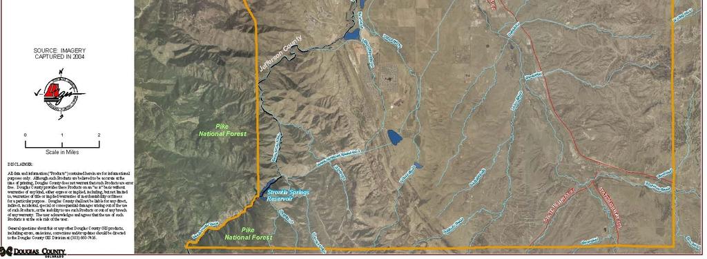
15 Chatfield Basin Green Infrastructure Study Area
16 special places by providing the information and tools needed to secure a functioning, interconnected system of green infrastructure. CBCN envisions that this Project will guide land use decisions as part of an ongoing dialogue that will take place as Douglas County begins its next revision to the Douglas County Comprehensive Master Plan later in To facilitate this dialogue, this Project will: Promote a better understanding of the Chatfield Basin s unique and significant natural and cultural resources. Identify and prioritize areas to be included in a system of green infrastructure. Provide an understanding of the opportunities and constraints to securing green infrastructure in the Chatfield Basin. Offer recommendations on how to ensure a functioning system of green infrastructure within the Chatfield Basin. While individual CBCN stakeholders may not be of one mind regarding the future of the Chatfield Basin, most agree that forethought, strategic action, and creativity will help secure the long-term quality of life for people and sustainability of nature within the Basin. 3.2 Green Infrastructure Defined Just as manmade infrastructure (gray infrastructure) such as interconnected highways, canals, utility lines, telephone lines, and railroads represents the life support system of modern society, green infrastructure supports natural systems and processes. In order to function properly, gray infrastructure is planned and strategically located to interconnect places where people live, work and play. Similarly, a functioning ecological system consists of interconnected places for wildlife to nest, forage, breed, move and rest; for plants to grow, reproduce, and disperse; and for the flow of water, water filtration and flood attenuation. Karen S. Williamson s Growing with Green Infrastructure states the social consequences of allowing our natural systems to become fragmented as a decline in the productivity of the environment to support human activities and the alienation of man from nature. Review of other community green infrastructure plans reveals a variety of visions and goals of how green infrastructure relates to their communities. In the City of Auburn, Alabama, green infrastructure is made up of those areas that are critical to wellbeing, whether the particular resource affects the economy, quality of life or the health and safety of residents (City of Auburn 2004). Auburn s approach focuses on the quality of life of its community. In Prince George s County, Maryland, stakeholders developed a plan to preserve, enhance, and/or restore an interconnected network of countywide significant environmental features that retains ecological functions and maintains or improves water quality and supports the - 7 -
17 [County s] desired development pattern (The Maryland-National Capital Park & Planning Commission See Appendix 6 Green Infrastructure Case Studies p. 68). Many communities adapt their definition of green infrastructure from the President s Council on Sustainable Development s May 1999 report Towards a Sustainable America Advancing Prosperity, Opportunity and a Healthy Environment for the 21st Century. This report defined green infrastructure as: Our nation s natural life support system an interconnected network of protected land and water that supports native species, maintains natural ecological processes, sustains air and water resources and contributes to the health and quality of life for America s communities and people. Chatfield Basin Conservation Network stakeholders, during the Green Infrastructure kick off workshop on November 2004, adapted the President s Council definition to define green infrastructure in the Chatfield Basin as: An interconnected network of wildlife habitats, greenways, riparian areas, wetlands, recreation, conservation and other natural areas. This interconnected network supports biodiversity and native species, maintains healthy natural and ecological processes and services and provides recreational and other outdoor opportunities that contribute to the health, quality of life, and sense of place for our communities. Reasons to Manage and Restore Native Open Space Because we want to: It s beneficial Cleans and purifies our water Cleans the air and produces oxygen we need to breathe Reduces air temperatures on hot summer days Provides habitat for the animals and plants we enjoy seeing Provides children and adults an opportunity to learn about the environment Provides inspiration for artistic, written and photographic images Provides a place for spiritual and emotional renewal Defines, identifies and separates regions, communities, neighborhoods and neighbors Provides a sense of history what the landscape may have looked like prior to settlement Provides recreational spaces for walking, jogging, bicycling, and canoeing for example Helps maintain property values Protects community investment Because we need to: it s part of local planning documents and guidelines Comprehensive Master Plans Zoning Resolutions Covenants Because we have to: It s the law Colorado Noxious Weed Law Revised Statute County weed ordinances Rare & Endangered Species Habitat protection A number of key concepts are imbedded in this definition. First, green infrastructure considers both natural and human elements of nature and the outdoors. Second, the definition recognizes that interconnectedness and maintaining healthy natural processes are important to the ongoing capacity of green infrastructure. Third, good health and quality of life are important characteristics of the cultural elements of green infrastructure

18 3.3 Elements of Green Infrastructure Sense of Place Backcountry Wilderness Area of Highlands Ranch The Backcountry Wilderness Area of Highlands Ranch hosts views of the Chatfield Basin, the Front Range Mountains from Pikes Peak to Longs Peak, and the mosaic of habitats found in this ecological crossroad. Chatfield Basin Conservation Network stakeholders considered the green infrastructure definition and concepts discussed above in identifying four key green infrastructure elements. These elements are listed below and are the focus of the Green Infrastructure Project. Water Wildlife and wildlife habitat Recreation Sense of place These green infrastructure elements play individual and collective roles in fulfilling the definition of green infrastructure in the Chatfield Basin. Individually, each green infrastructure element has its own functions and processes that can be identified, mapped and protected. On the other hand, the green infrastructure elements are interrelated with the potential to positively or negatively affect one or more of the other identified elements. For instance, water quality and availability affects the quality of riparian habitat. Alternatively, Roxborough State Park, identified as a sense of place feature, provides recreational opportunities and connection to wildlife habitat. Similarly, recreational experiences are enhanced by a connection to wildlife habitat and water resources. Because the green infrastructure elements are both distinct and related to each other, the recommendations contained in this Project report represent the proposed green infrastructure systems for each element, and an overall system representing all the green infrastructure elements. Numerous CBCN stakeholders provided their expertise and knowledge as part of stakeholder teams (see Appendix 2, p Stakeholder Teams) to analyze each of the four green infrastructure elements. The teams used a scaled approach adapted from Ecology of Greenways (see Table 3 p. 50, Appendix 2, p. 53), moving from a broad view to an increasingly narrow focus, to analyze the elements of green infrastructure. The stakeholder teams first identified the following: The Douglas County East-West Trail travels through the Backcountry Wilderness Area of Highlands Ranch and will provide miles of multi-use trail enjoyment
19 Sense of Place Chatfield State Park Nearly one and a half million people enjoy Chatfield State Park s variety of recreational amenities annually. 1. Functions: Identify the element s broad scale roles and functions within the context of its ecological or cultural system. For example, the ecological functions identified for water systems include water quality, water transport, flood attenuation, and wildlife movement corridors while the cultural functions include recreation, wildlife viewing opportunities, and connection to nature. 2. Components: Define the characteristics of each green infrastructure element that are needed to ensure the functioning of the element s ecological or cultural system. For example, a properly functioning recreational system may need to have a combination of interconnected regional, local and neighborhood trails providing opportunities for different types of trail use (e.g. regional multi-purpose trails, neighborhood nature trails, local bike trails). These characteristics are referred to as the components of the element. 3. Features: Describe at a landscape level the specific characteristics or places that exemplify the functions and components of the element. Cherokee Ranch is an example of a sense of place feature within the Chatfield Basin. Once the functions, components and features for each green infrastructure element were identified, the stakeholder teams identified patterns, alignments, and unique places needed to ensure interconnectedness and/or functionality for that green infrastructure element. For the purposes of this Project, indispensable patterns or critical alignments are defined as gaps in protection, essential unprotected linkages, or rare features that occur within the identified system of green infrastructure. In some cases, the stakeholder teams did not have enough information to recommend a specific location for a particular green infrastructure swath. In those circumstances, future analysis, such as the Conservation Quality Assessment (CQA) developed as part of this Project, may be needed to better understand the green infrastructure element s functions and components, as well as the direct and indirect impacts of existing or proposed land uses on the proposed system of green infrastructure. See Appendix 7, p. 84 for an overview of the CQA conducted in November 2004, as part of this Green Infrastructure Study. Such additional assessments may be conducted in conjunction with land management activities and during development reviews. Traverse the top of the earthen dam at Chatfield Lake, and enjoy the beautiful 360-degree picture perfect views of the Chatfield watershed

20 Sense of Place Cherokee Ranch and Castle The following analysis of each green infrastructure element is the result of stakeholder team meetings, data collection and review, the CQA, and other research and analysis conducted by the Project team and CBCN stakeholders. 3.4 Water The Chatfield Basin is a sub-basin of the South Platte River Basin located within a semi-arid climate zone where water availability Where Colorado is limited. The Basin s low-lying, grassland center is surrounded history, an agricultural at the edges by higher terrain, (the Mountain Backdrop to the way of life and nature west and elevated areas to the east), with its river system meet. draining into the Chatfield Reservoir. Plum Creek and its tributaries are characterized as undammed, unchannelized streams with wide flood plains and wetlands, which contribute greatly to water quality and flood control in the region (Chatfield Basin Conservation Network 1998 Concept Plan). Groundwater and surface water supplies within the Basin are constrained. The limited supply of water is a significant consideration for future development within the entire Chatfield Basin. While recognizing that water supply impacts future land uses, this report primarily evaluates land use effects on surface water resources as those resources relate to a functioning system of green infrastructure. Because of the Basin s topography and soil characteristics, the members of the Water Stakeholder Team (WST) recognized that standard development practices have the potential to alter natural hydrologic patterns and water quality. (WST Meeting, February 17, 2005.) The WST expressed a preference for utilizing multi-discipline processes and approaches associated with low impact development techniques. Low impact development helps promote naturally functioning water systems while providing for water quality and flood attenuation characteristics. To encourage this approach, the WST identified the functions and components within the study area that are the most vulnerable to development and if protected would promote water quality and flood control. With a commanding view of the Rocky Mountains, Cherokee Castle overlooks 14,000 acres of open space

21 3.4.1 Water Functions, Components and Features Sense of Place Daniels Park Functions The WST identified the following functions as characteristic of a properly functioning, natural water system: Ecological and/or Hydrological Functions Aquifer/groundwater recharge Water transport Water quality Erosion control Flood attenuation Stream flow Habitat and wildlife movement corridor Come have a picnic at Daniels Park to enjoy the magnificent panoramic view of the Mountain Backdrop and entire Chatfield Basin as buffalo roam only a few feet away. In addition to the ecological functions identified above, the WST identified the following cultural functions of water systems: Cultural Functions Drinking water Recreation Connection to nature Wildlife viewing Outdoor education Components Using their professional expertise, information from the Douglas County Mineral Extraction Plan, the Urban Drainage & Flood Control District s 2001 Plum Creek Watershed Flood Hazard Area Delineation, Douglas County s Habitat Conservation Plan, and Douglas County GIS soil and hydrology mapping; the WST identified the following land-based components that are part of a functioning water system supporting the functions identified above. 100 year flood-plain: As identified by the Federal Emergency Management Agency (FEMA) the 100-year flood-plain is the area adjoining a river, stream, or watercourse covered by water in the event of a 100-year flood or a Base Flood, which is defined as the flood having a one percent chance of being equaled or exceeded in magnitude in any given year. Contrary to popular belief, it is not a flood occurring once every 100 years. The first 40-acre area at the Daniels Park shelter house was given to the City of Denver in The remaining 1000 acres was donated in Most of the park is a Bison preserve and natural area where visitors can view the animals in a high-plains habitat
22 Flood-plain deposits: Water-deposited gravel, sand, silt, and clay along present stream courses (Douglas County Mineral Extraction Plan, 1990) Riparian Conservation Zone (RCZ): An area delineated along non-federally owned reaches of Cherry Creek, Plum Creek, the South Platte River and their tributaries that include the active stream channel, alluvial floor, upland side slopes adjacent to the channel or alluvial floor, and a component of the upland vegetation adjacent to the upland side slopes. The RCZ was defined as part of the Douglas County Habitat Conservation Plan (DCHCP) developed to protect the Preble s meadow jumping mouse in order to comply with the Endangered Species Act (Douglas County Habitat Conservation Plan 2006). Stream Terrace Fill Deposits: Older stream deposits occurring as benches flanking present stream course. (Douglas County Mineral Extraction Plan) Valley-fill Deposits: Smaller and less distinct terraces of water-deposited gravel, sand, silt, and clay along present stream courses. (Douglas County Mineral Extraction Plan) Wetlands: Transitional lands between terrestrial and aquatic systems where the water table is usually at or near the surface or the land is covered by shallow water. (US Fish and Wildlife Service) These components are identified and mapped in Figure 2 -- Water Resources, p. 95. Features The water features within the study area are self-evident and are as follows: Chatfield Reservoir Streams and tributaries of the South Platte River and Plum Creek High Line Canal Stream Confluences Indispensable Patterns and Critical Alignments The WST identified the following components as vital in maintaining the naturally functioning water systems within the study area: 100 year flood-plain Wetlands Riparian conservation zone Valley-fill deposits Flood-plain deposits
.")
23 These components, which are represented separately in Figure 2, Water Resources p. 95, were combined to create the Water Protection Areas Sense of Place depicted on the CBCN Green Infrastructure System map (see Dupont Figure 7, p. 100). Areas identified as containing stream terrace fill deposits were not identified as indispensable because these deposits are more widely distributed within the study area and best management practices can be readily implemented to help reduce impacts to water resources potentially influenced by stream terrace fill deposits. 3.5 Wildlife and Wildlife Habitat The public s desire to protect wildlife and wildlife habitat has been documented in numerous public opinion surveys conducted in the last few years. For example, in 1998, Douglas County conducted a survey as part of its update to the Douglas County Parks, Trails and Open Space Master Plan. This survey revealed that Douglas County residents ranked wildlife as the most important natural resource value in the County. This factor influenced both the revision of the Parks, Trails and Open Space Master Plan as well as the Douglas County 2020 Comprehensive Master Plan. Additionally, the preservation of wildlife and wildlife habitat is one of the original priorities of the CBCN. During its meetings, the Wildlife and Habitat Stakeholder Team (WHST) echoed the words from the 1998 Concept Plan, that the Chatfield Basin lies at an ecological crossroads where the Rocky Mountains meet the High Plains and the southern desert lands meet the northern boreal forest. This ecological crossroads provides a great diversity of plants and animals as described in Section 3 above. As part of its work, the WHST identified key wildlife species and the types of habitat the species use within the Chatfield Basin. This information is contained in Appendix 3, p. 55. To identify the key wildlife and habitat characteristics to be considered as part of the functioning system of green infrastructure within the Chatfield Basin, the WHST identified the following functions, components and features. In 2002, Dupont gave 505 acres of its Louviers property (valued at $3.7 million) to Douglas County and The Conservation Fund. The donation includes the 8-acre Dupont Park


24 Sense of Place High Line Canal Wildlife and Wildlife Habitat Functions, Components, and Features Denver s historic water lifeline, the Highline Canal now provides a 66-mile ribbon of nature with trail experiences from Waterton Canyon to Aurora. Functions WHST considered both ecological and cultural functions of wildlife and wildlife habitat green infrastructure. As a result, the Team determined that wildlife and wildlife habitat green infrastructure within the Chatfield Basin provides a combination of the following functions: Biodiversity Wildlife movement connections Core wildlife habitats Buffer or transition areas to core habitats Stepping stone habitats Watchable wildlife Connection to nature for people Components While there are numerous types of vegetation and habitat in the Chatfield Basin, the WHST generalized habitat into the following categories to simplify the analysis and recommendations: Open water Riparian Grassland Shrub land Forest Shrub land/grassland Interface Edge Shrub land/grassland Interface Mosaic These habitat categories were mapped by combining similar vegetation type layers from the Douglas County GIS vegetation data (see Figure 3, Wildlife Habitat Areas, p. 96). For example, vegetation categorized as coniferous trees were combined to create the forest habitat component. Areas with primarily grassland species or otherwise lacking in woody cover were condensed into the grassland habitat component. The canal is at an elevation of 5,442 feet at intake and 5,410 feet at its terminus
25 Features Conservation plans focus often on the protection of keystone (rare or economically important) species and their habitat. Here, the focus of the Chatfield Basin Green Infrastructure Study is to facilitate the protection of an interconnected system of a variety of habitat types to help ensure a varied and viable ecosystem that will sustain the greatest diversity of species, and increase the carrying capacity of the area. To that end, the WHST identified the following diverse set of habitat features within the Chatfield Basin. Wetlands and riparian areas: Land managers now recognize the vital importance of wetlands and riparian areas to the overall health of ecosystems. Less than three percent of Colorado s surface area is composed of natural wetlands (Dahl 1990), or as riparian areas (Colorado Partners in Flight). The occurrence of wetlands and riparian areas are equally as rare in the Chatfield Basin. Wetlands and riparian areas make up a network of important wildlife habitat that provides one or more of the life cycle needs (nesting, cover, resting, dispersal, migration resting, feeding and watering stopover areas, or movement corridors) of likely more than 80 percent of the Basin s resident bird species (Knopf et al, 1988). Similarly, other wildlife species such as insects, reptiles, and small and large mammals use riparian areas for feeding, watering, shelter, breeding, resting, and movement. Mid and tall-grass remnants: Historically, the Chatfield Basin s grassland areas were dominated by mid and tall-grass populations supporting a diverse suite of wildlife species distinct from those found on short-grass lands. Mid and tallgrassland areas have declined to the point where only remnants exist. Along with the decline in this habitat type has come the near extirpation in the Chatfield Basin of wildlife species such as the Plains Sharptail Grouse. Additional study needs to be conducted to identify where intact remnant grassland remains; assess the overall health and viability of the grassland areas; and assess the potential for restoration and/or expansion of these areas. Hogbacks and Breaks in Hogbacks: One of the most striking and unique features of the Chatfield Basin is the hogback, which forms the eastern edge of the Mountain Backdrop. The Hogbacks are unique areas along the Front Range that mark flyways for raptors; provide a unique location for rare vegetation; and serve as habitat for wildlife. In particular, the breaks in the hogback are frequently accompanied by drainages supporting a band of riparian vegetation. The breaks serve as a natural movement corridor from the forested mountain backdrop to the Basin s grassland center. US-85 Habitat Connections: A synergy occurs within large connected blocks of habitat that does not exist for an equal amount of habitat broken into smaller disconnected pieces. As US Highway 85 receives more use and eventually is expanded in accordance with the Colorado Department of Transportation s plans, this roadway will become a formidable barrier to wildlife movement between the
26 over 11,000 acres of protected habitat to the east and thousands of acres of protected land, including the Pike National Forest, to the west. This barrier effect can be mitigated by providing adequate wildlife underpasses or overpasses, and ensuring that approaches to crossings are inviting to wildlife. Such crossings for wildlife to pass to and from protected core areas are an essential feature in creating a functioning system of green infrastructure. Contiguous Grasslands: The Chatfield Basin contains relatively large areas of contiguous grassland. Many wildlife species depend on these grassland areas, and are often more sensitive to disturbance than other species that use shrub land or forested habitat types. One of the major reasons for this sensitivity is that trees, shrubs, and topographic relief muffle noise and diminish sight distance, effectively minimizing the effects of human and domestic animal disturbance. Within grassland areas, there is nothing to diminish the noise or separate wildlife from traffic, humans walking or recreating, dogs on trails, or other disturbance. Therefore, many grassland species require larger tracts of contiguous grasslands if they are to remain in an area. However, these large contiguous grassland areas are seen as the most at-risk habitat type in the Chatfield Basin due to the relative lack of physical or regulatory impediments to land use changes, and their proximity to already-constructed infrastructure. Intermixed Shrubland/Grassland Areas: In addition to its unique and appealing appearance, areas with intermixed shrub land and grassland provide excellent wildlife habitat. Some species of wildlife, such as the Plains Sharptail Grouse, are specifically adapted to this habitat type. The shrubs can provide nesting or loafing sites, escape cover, shelter, and alternative food sources for species that use both habitat types. Grasslands provide good foraging areas, ground nesting sites, and mating sites. Many species, such as the red fox, take advantage of the edge (the interface between two habitat types) to hunt, instinctively realizing that there is a greater chance of finding prey if they are hunting two habitat types simultaneously Indispensable Patterns and Critical Alignments Forman and Collinge define four types of indispensable landscape patterns: Large patches of natural vegetation, Connectivity between patches, Vegetated corridors along streams, Bits of nature scattered through the ecologically less-suitable matrix that serve as stepping-stones or neighborhood habitats. Critical alignments are those places within a system of green infrastructure that are irreplaceable or strategically essential to the overall functioning of the system over the long term. For the purposes of this Project, the identified indispensable patterns
27 and critical alignments consist of unprotected places needed to secure a properly functioning system of green infrastructure. Comparing Figure 3, Wildlife Habitat Areas, p. 96, with Figure 6 the CBCN Opportunities and Constraints Map, p. 99, the WHST identified the following as indispensable patterns and critical alignments. These indispensable patterns and critical alignments are further reflected in the CBCN Green Infrastructure System map, Figure 7, p Indispensable corridors and linkages Riparian corridors (with a component of upland habitat) Hogbacks and breaks in Hogbacks Core grassland conservation area linkages Stepping-stone habitat (where contiguous open space linkages are not feasible) Indispensable Core Habitat Areas Regional core grassland areas Core areas of interconnected shrub lands, grasslands, and scrubland/grassland interface areas Habitat for strategic species (e.g. viable prairie dog towns and buffer areas) Wetlands Critical Alignments Underpasses or at-grade crossings for large roadways and railroads (additional underpasses may be necessary for Highway 85) Approaches to underpasses or at-grade crossings Confluences of riparian and stream corridors Buffers between development and core conservation areas 3.6 Recreation The study area contains diverse recreational opportunities, which provide access to, and create appreciation for, a wide variety of landscapes and natural areas, as well as cultural and historic places. Trail corridors within the study area travel through: Urban open spaces Highlands Ranch trail system Developed recreation areas Chatfield State Park Natural areas Roxborough State Park Vast open spaces Cherokee Ranch and the Back Country Wilderness Rugged mountain terrain - Indian Creek Trail

28 Sense of Place Hogbacks In total, trails throughout the study area accommodate moderate to intense recreational opportunities for residents and visitors. In addition, the study area hosts numerous recreational hubs or centers providing a variety of outdoor opportunities ranging from active (boating, camping, hot air ballooning, horseback riding, and mountain biking) to passive (hiking, wildlife and bird watching, cross-country skiing, and outdoor education). All of these recreational opportunities are part of a complex system of recreational infrastructure contained within the study area. Information in this report is intended to help recreational managers coordinate their efforts to provide a regional, interconnected system of trails supporting a wide range of functions. The Recreation Stakeholder Team (RST) identified recreation functions and the trail components that make up a system of regional, local, and neighborhood trails which connect to parks, natural areas, and interpretive sites. The features identified below are regional trails that should be connected as part of a functioning system of green infrastructure. Local and neighborhood trails that will ultimately become part of a functioning system of green infrastructure were not mapped as part of this Project. However, local and neighborhood trail locations are more appropriately addressed as individual opportunities are presented Recreational Functions, Components, and Features The RST analyzed the recreational system and identified functions, components, and features. First, the RST defined the recreation functions by identifying the current recreational opportunities within the study area. Further, the RST identified the general components within a recreational system that provide those functions. The features, which are primarily regional trails, are those specific places that incorporate the identified features and components. The functions, components and features are identified below. Functions As discussed above, the RST identified the following as key recreation functions within the Chatfield Basin. Breaks in the hogbacks serve as important places for wildlife to move back and forth from the forested mountain backdrop to Chatfield s grassland areas
29 These functions represent the types of experiences that may be encountered when recreating within the Chatfield Basin. Variety of trail experiences including road and mountain bike, pedestrian, equestrian, greenway, and multiuse Outdoor enjoyment such as wildlife viewing, fishing, hunting, and photography Opportunities for kids including unstructured play Natural and historic interpretation Connecting people to the land and water Opportunities for those with disabilities Opportunities for people with dogs Picnicking Boating Archeological Fishing and hunting Birding Ecotourism Horseback Riding Components The RST identified the following recreation components that occur within the Chatfield Basin that provide the functions or experiences identified above. Regional trails Local trails Neighborhood trails Regional and local parks and natural areas for passive recreational opportunities Active park nodes Interpretive sites Water ways Features Connectivity is generally associated with a system of green infrastructure. The recommendations provided in this section of the report primarily relate to regional trails, which are identified below. These features provide the spine for a trail network. Existing local and neighborhood trails should connect to the regional trail system. Highline Canal Vista Trail East/West Trail Proposed Plum Creek Trail Sharptail Ridge Trail Pike National Forest
30 The RST identified a number of existing gaps, in the study area s recreational functions, components, and features that must be filled to ensure a properly functioning recreational green infrastructure system. These gaps, or future needs, include: An east-west trail connection south of Lambert Ranch Lack of recreational opportunities in and around Lamb Spring, Louviers/Dupont property, and the edges of Cherokee Ranch Lack of single track trails Lack of recreational nodes in the southern part of study area Need for urban mountain biking opportunities Need for more watchable wildlife opportunities Indispensable Patterns and Critical Alignments The RST identified the following indispensable patterns and critical alignments as essential to ensuring a functioning system of recreation green infrastructure. Recreational green infrastructure is shown in Figure 5, p. 98. Connections among regional trails Local and neighborhood trail linkages to identified regional trails corridors Places with opportunities to see wildlife and otherwise experience nature and solitude Connections to recreation destinations Places with important local or long-distance views 3.7 Sense of Place Sense of place is the personal identification with or recognition of a place based on ecological, cultural, and landscape characteristics. These places tend to define a community by providing opportunities for people to visually and emotionally connect to their surroundings. Sense of place represents emotional responses and personal preferences, and is in part an expression of how people view their quality of life. As such, it is not science. However, some believe that incorporating sense of place into resource management helps to bridge the gap between ecosystem management and how people respond to and interact with natural processes. In the Journal of Forestry, Daniel R. Williams and Susan I. Stewart write, sense of place offers resource managers a way to identify and respond to the emotional and spiritual bonds people form with certain spaces (1998). In a broad sense, the Sense of Place Stakeholder Team (SPST) believes that sense of place in the Chatfield Basin represents a crossroads in time, culture, and experience. The relationships between the sense of place green infrastructure element and wildlife and habitat, water, and recreation elements are intertwined and difficult to

31 Sense of Place Ken-Caryl Ranch neatly map or quantify. The SPST developed lists of the various functions, components, and features, and located the specific sense of place features in Figure 4, Sense of Place, p. 97. In addition, the features representing the Chatfield Basin s sense of place are highlighted as sidebars throughout this report Sense of Place Functions, Components, and Features During its meetings, the SPST brainstormed to identify key functions, components and features that are essential to the Chatfield Basin s sense of place green infrastructure. The results of these brainstorming sessions are provided below. Functions After viewing a photographic introduction of the Chatfield Basin, the SPST was asked to brainstorm both obvious and subtle characteristics that they as individuals enjoy or appreciate about the Chatfield Basin. These characteristics are referred to here as functions, and are often based on emotional responses and personal interpretations of the sights, smells, noises and feel of a place. The following are the functions identified by the SPST. Archeological appreciation Sense of connection to place Connections to nature and the Connections to local history outdoors and culture Sense of time (daily, monthly, Spatial separation from yearly and geologic) development Solitude Soul/spiritual Opportunities to see wildlife Personal interests Unobstructed views of Stewardship development and nature demonstration Respite from development Familiarity with a place Passive recreation Trash and clutter free Visual quality Rural feeling (nature, farms) Emotional umbrella Sense of connection to place Interpretive Signs Archeological appreciation Meaning/stories Passive recreation Ken-Caryl Ranch provides ample opportunity to experience history, culture, and nature
32 Components The SPST reflected on the functions listed above and identified places within the study area that exhibit or provide a place for those functions to occur. The identified places are considered sense of place components and are listed below. Streams and their sub-basins Isolated places to experience daytime quiet and the night sky Elevated areas to the East and West that provide views and view platforms Place where roads and trails cross creeks Prairie intermingled with shrub lands, especially shrub oak Historic and cultural significant places Opportunities for serendipity Remnants of tall, mid and short grass prairie Places to learn and teach Features Numerous identifiable features within the study area create a sense of place both on a Basin-wide scale, such as the Front Range Mountain Backdrop, and on a more localized scale, such as the riparian forest near Louviers. These places provide recreation, quality of life, economic, education, and many other benefits to the community. All of these features have been identified and located as part of Figure 4, p. 97. In addition, each feature is briefly described in sidebars throughout this report. Audubon Center at Chatfield Backcountry Wilderness Area of Highlands Ranch Chatfield Reservoir and State Park Cherokee Ranch and Castle Daniels Park Deer Creek Canyon Open Space Denver Botanic Gardens at Chatfield DuPont Property High Line Canal Hogbacks Ken-Caryl Ranch Lamb Springs Louviers Mountain Backdrop Riparian Forest in Louviers Roxborough State Park Sharptail Ridge Open Space and Trail South Platte Park Viewsheds from Highway 85 Waterton Canyon Indispensable Patterns and Critical Alignments People respond to sense of place features through their experiences of seeing, smelling, touching, and hearing while visiting or viewing the features from afar. Because many of the features identified above are already protected, preserving the Chatfield Basin s sense of place may be more about protecting experiences than it is about protecting the features themselves. Therefore, understanding the particular
33 Sense of Place Lamb Spring "Because it is located in the Denver metropolitan area, Lamb Spring provides unusual opportunities for public education and participation in science." functions of each sense of place feature is essential to understanding how to maintain the Basin s sense of place. Table 1, p. 25, Sense of Place Features and Associated Functions Identified by SPST, provides a complete listing of each of the features accompanied by its associated sense of place functions. This list provides important information that should be considered when reviewing changes in land use adjacent to any of the identified sense of place features and should be given careful consideration, in order to create future community connections. Sense of Place features are also mapped on Figure 4, p. 97. In addition to the information provided in Table 1, the SPST identified the following indispensable patterns and critical alignments as those essential for ensuring that the qualities that define sense of place features are maintained and recognized. Indispensable Patterns Places with local or long-distance views of sense of place features Views from identified sense of place features Views that define the unique character of the Basin, including expanses of grasslands, ranchlands, geologic formations, and more intimate views of historic structures and other landmarks Feature buffers to minimize noise pollution and visual intrusions Mosaics of forest, riparian, shrub land and prairie communities with rock out crops and other geologic features. It is this mosaic or interdidgitation of aspects of the plains and mountains that make it visually and ecologically interesting Critical Alignments Critical alignments for the sense of place green infrastructure element include those areas that serve as viewing platforms for a large number of people or areas that are Researchers at the University of Colorado at Boulder have excavated the skull and tusks of a mammoth that died more than 10,000 years ago in what was once a freshwater spring near Roxborough State Park
34 so unique that disrupting the view would severely impact the Basin s sense of place. Views from Highway 85 East to Cherokee Ranch (particularly the Castle) Views of the Mountain Backdrop Views south from Highway 85 to Pikes Peak. Views from Chatfield Reservoir to the Mountain Backdrop and Pikes Peak Table 1. Sense of Place Features and Associated Functions (See Figures 4 & 7). Feature Audubon Center at Chatfield Backcountry Wilderness Area of Highlands Ranch Chatfield Reservoir and State Park Cherokee Ranch and Castle Daniels Park Deer Creek Canyon Open Space Denver Botanic Gardens at Chatfield DuPont Property High Line Canal Hogbacks Ken-Caryl Ranch Trails Lamb Springs * Louviers Mountain Backdrop Louviers Gallery Forest Roxborough State Park Associated Functions Outdoor enjoyment; connection to nature; interpretive and educational opportunities; respite from development and outdoor experiences. Connections to local history and culture; connections to nature; solitude; unobstructed views; respite from development; sense of time (daily, monthly, yearly, and geologic); passive recreation; interpretive opportunities; sense of connection to place; visual quality; personal interests; stewardship development and demonstration; spatial separation; rural feeling (nature, farms); and outdoor experiences. Outdoor enjoyment; connection to nature; passive and active recreation; interpretive opportunities; personal interests; spatial separation; access to water resources; and outdoor experiences. Connections to local history and culture; connections to nature; view of Mountain backdrop; views to Cherokee Ranch and Castle; respite from development; sense of time (daily, monthly, yearly, and geologic); interpretive opportunities; meaning/stories; connection to place; soul/spirit; spatial separation; and rural feeling (nature, farms). Connections to nature; solitude; unobstructed view to mountain backdrop and of the Chatfield Basin; respite from development; sense of time (daily, monthly, yearly, and geologic); connection to place; and geology. Outdoor enjoyment; connection to nature; respite from development and outdoor experiences, solitude, visual quality, views of the Chatfield Basin. Connections to local history and culture, connections to nature; solitude; sense of time (daily, monthly, yearly, and geologic); passive recreation; emotional umbrella; interpretive opportunities; connection to place personal interests; stewardship development and demonstration; spatial separation; connection to plants and animals; rural feeling (nature, farms); and outdoor experiences. Connections to local history and culture; connections to nature; respite from development; connection to place: visual quality; and spatial separation. Connections to local history and culture; connections to nature; solitude; respite from development; passive recreation; interpretive opportunities; sense of connection to place; visual quality; access to water resources; and outdoor experiences. Sense of time (geologic); connection to place; visual quality; spatial separation; and provides familiarity with a place. Connections to local history and culture; connections to nature; passive recreation; connection to place; and outdoor experiences. Archeological; future opportunities may include connections to nature; sense of time; passive recreation; interpretive opportunities; and connection to place. Connections to local history and culture; connection to place; visual quality; and soul/spirit. Unobstructed views; respite from development; emotional umbrella; connection to place; visual quality; special separation; and familiarity with a place. Connections to nature; solitude; respite from development; reminder of seasons; connection to place; visual quality; and spatial separation. Connections to nature; solitude; unobstructed views; respite from development; passive recreation; interpretive opportunities; connection to place; visual quality; personal interests; stewardship development and demonstration; spatial separation; geology; and outdoor experiences
35 Feature Sharptail Ridge Open Space and Trail South Platte Park Highlands, Eastern Waterton Canyon Associated Functions Connections to nature; solitude; unobstructed views; respite from development; passive recreation; interpretive opportunities; visual quality; and outdoor experiences. Link to flood history and floodplain conservation (set precedent for US flood control projects?); major recreational trail hub along the South Platte River, opportunity for wildlife viewing and solitude within suburban area, designated Important Bird Area and is a migration stopover point; connections to local history and culture; connections to nature; solitude; respite from development; passive recreation; interpretive opportunities; sense of connection to place; visual quality; and outdoor experiences. Access to water resources. Connections to local history and culture; connections to nature; unobstructed views; connection to place; visual quality; spatial separation; familiarity with a place; and rural feeling (nature, farms). Connections to local history and culture; connections to nature; respite from development; passive recreation; connection to place; outdoor experiences and access to water resources. *Due to historical sensitivity, the Lamb Spring Archeological site is not mapped at this time. 4.0 Opportunities and Constraints to Protecting Green Infrastructure The Chatfield Basin Conservation Network stakeholder teams identified numerous potential opportunities for and constraints to protecting a functioning system of green infrastructure. These include current and future land use patterns, regulatory measures, funding, implementation, resource conditions, and others. These factors are discussed below. 4.1 Land Use Patterns The CBCN stakeholders used existing information, data, mapping, and observations gathered during the 2005 CQA to identify: Existing or planned development Existing zoning for future development Protected and conserved areas The stakeholders review and assimilation of all data, mapping and observations gathered is documented, in part, in Figure 6, Land Use Opportunities and Constraints, p. 99, and Appendix 7, p. 84. The Land Use Opportunities and Constraints Map provides an overview of existing development patterns as they relate to the existing network of conservation areas. This map establishes an understanding of what development potential exists under current Douglas County policies and regulations as of 2005, and how these land use patterns influence securing a functioning system of green infrastructure. The six land pattern classifications depicted on the Land Use Opportunity and Constraints Map are described in detail below. The identified land classifications
36 represent a spectrum of opportunities (from greatest opportunity to most constrained opportunity) for protecting or enhancing the system of green infrastructure. Core Conservation Areas -- Greatest Opportunity to Enhance and Maintain Existing Green Infrastructure: Over 51,000 acres within the Chatfield Basin have been acquired, donated, or otherwise designated as open space, parks, or National Forest (see Table 2). These core conservation areas provide a framework of secured green infrastructure and serve as the greatest opportunity for enhancing and maintaining the four identified green infrastructure elements. The land use pattern created by these core conservation areas serves as a guide for the recommendations for securing a functioning system of green infrastructure. Table 2. Chatfield Basin Core Conservation Areas (as of August 2005) Protected Area Management Agency Acreage Belfield * Douglas Land Conservancy 119 Chatfield Reservoir U.S. Army Corps of Engineers 775 Chatfield State Park Colorado State Parks 5378 Cherokee Ranch Easement Douglas County Easement Holder 3000 Cleveland Easement* Douglas County/ DLC Easement Holder 105 Daniels Park Denver Parks 960 Deer Creek Canyon Jefferson County Open Space 1721 Denver Botanic Gardens at Chatfield Denver Botanic Gardens 750 Duncan Ranch Easement* Douglas Land Conservancy 475 Dupont* Douglas County 506 DuPont Conservation Easement* Douglas County/The Conservation Fund 349 Highlands Ranch Open Space Metropolitan District of Highlands Ranch 2200 Hildebrand Ranch* Jefferson County Open Space 1453 Backcountry Wilderness Area of Highlands Ranch Shea Homes (to be conveyed to the Highlands R Community Association) Ken-Caryl Ranch Ken-Caryl Ranch Metropolitan District 4878 Koebel (South Cherokee Ranch) * Douglas Land Conservancy Lamb Springs Archeology Conservancy 35 N Willow Creek Ranch/Sharptail Ridge* Douglas County/DOW 698 Nelson Ranch* Douglas County/Douglas Land Conservancy 565 Nelson Ranch Easements* Douglas County/Douglas Land Conservancy 130 Pike Hill* Douglas County 308 Pike National Forest U.S. Forest Service 9000 Pine Cliff Ranch Colorado Open Lands 3440 Red Mesa Ranch* Douglas County 245 Roxborough State Park Colorado State Parks
37 Protected Area Management Agency Acreage South Platte Park S. Suburban Park and Recreation District 662 South Valley Open Space Jefferson County Open Space 888 Waterton Canyon Denver Water 215 Woodhouse Property Colorado Division of Wildlife 840 Young* Douglas County 80 Total Protected Acreage * Core Conservation Areas protected since Acres- Greatest Opportunity: Areas identified in Figure 6 (p. 99) as Nonurban Areas, are scattered throughout the study area. These provide large areas of contiguous wildlife habitat; many identified water components; and a variety of sense of place functions. These larger properties represent the greatest opportunity for expanding the current framework of secured green infrastructure by providing large contiguous areas; buffers from development; connections between core conservation areas; and other identified indispensable patterns or critical alignments, for example tall and short grass prairie remnants, and rare species habitat as discussed in Section 3 above. Within these areas, opportunities exist to reach out to landowners to discuss specific land management issues with the potential of impacting green infrastructure. Examples of such land management issues include: Livestock grazing Fencing Soil erosion Weed control Habitat and water quality enhancement Future proposed development programs Opportunities also exist to promote green infrastructure-minded development patterns. For example, the County offers an incentive based process whereby a property that is 70+ acres can receive a density bonus in exchange for preservation of open space, wildlife habitat, and wildlife movement corridors, or green infrastructure. While the 70+ Acre areas present significant opportunities, the CBCN stakeholders recognize the private property rights and the limited governmental role associated with these properties, which may limit, or constrain, the opportunities to preserve the land as green infrastructure. Such constraints may include: Landowners unwilling to participate in outreach and management suggestions
38 Sense of Place Mountain Backdrop Limited funds to acquire necessary additions to green infrastructure system from willing sellers Limited governmental role in 35-acre+ developments Urban Areas- Good Neighborhood Opportunity: The urban areas identified in Figure 6, p. 99, include Highlands Ranch and Roxborough. The elements of green infrastructure within these urban areas are supported by neighborhood parks, trails and open spaces. There is ongoing opportunity within the urban areas to continue to provide valuable green infrastructure including recreational amenities such as trails and parks; wildlife habitat through the identification of open space; water resources through the creation of wetlands and storm-water management facilities; and preservation of a sense of place as residents continue to value a variety of opportunities within their own neighborhoods. Highway 85 Corridor- Constrained Opportunity: One of the most important green infrastructure features in the Chatfield Basin study area is Plum Creek. Plum Creek, an identified water feature within the study area, provides valuable wildlife habitat, recreation potential and many sense of place functions. The Highway 85 corridor parallels Plum Creek throughout most of the study area. It is home to two separate railroads, and has historically served as a focus for industrial and light industrial uses. These include Titan Road and the Reynolds Industrial Parks; a number of isolated industrial and commercial establishments, which include outside storage, salvage yards, and small manufacturing operations line. These industrial activities, in the past, have often been in direct conflict with the surrounding natural context. Because of this, the Highway 85 Corridor represents a constrained opportunity to both increase and maintain existing green infrastructure. However, opportunities potentially exist as land-uses applications, which may be able to mitigate potential impacts to water quality, wildlife habitat and movement, and the viewshed, as well as enhance or develop recreational amenities are initiated. Such opportunities will allow for the ongoing protection and enhancement of existing green infrastructure. Existing properties 35 acres to acres- Constrained Opportunity: These areas are scattered throughout the study area and influence each of the elements of green infrastructure. Opportunities to enhance or maintain green infrastructure elements impacted by properties that are less than acres, but more than 35 acres are constrained because of fractured ownerships, existing development patterns, and limited land use authorities. Nonetheless, many properties within this category are vitally important to the overall green infrastructure system due to their adjacency to key green infrastructure elements, including the Core Conservation Areas. The Front Range of the Rocky Mountains help to define every detail of life in the Rocky Mountain west from weather patterns, to scenery, from geographic orientation to outdoor recreation and countless more
39 Opportunities also exist to conduct ongoing outreach and education to help landowners understand their properties role within the system of green infrastructure. Contributions to the overall green infrastructure system can be achieved in this category by a coordinated effort to address the cumulative impact of these smaller properties. Existing properties 1 acre 34.9 acres -- Most Constrained: The areas identified in Figure 6, p. 99, as Most Constrained represents those properties that are less than 35 acres. Green Infrastructure is typically not incorporated into areas within this category due to a variety of factors, including historical rural development patterns, highly fractured ownership, existing residential and other development, and existing zoning. Green infrastructure is not typically as defined or as available in the most constrained areas including recreational opportunities such as neighborhood parks and trails or open space as examples. The increased presence of human activity on these smaller properties may also discourage or negatively impact wildlife. The ability to address green infrastructure within these areas will be limited. Opportunities for neighborhood green infrastructure elements may exist, but will require a highly coordinated effort among a variety of players. 4.2 Other Methods for Securing Green Infrastructure Through direct acquisition of open space, thousands of acres have been preserved in perpetuity, creating the backbone of the green infrastructure within the Chatfield Basin. While many favor direct acquisition of open space and green infrastructure, the funding needed for securing open space and green infrastructure through direct purchase is limited. In the face of limited funding for direct acquisition, numerous other opportunities exist to ensure that functioning green infrastructure is preserved. These opportunities include conservation easements, regulatory requirements, and preservation of green infrastructure elements through land use review. With the majority of the Chatfield Basin in private ownership, conservation easements provide incentives and long-term benefits to landowners through tax credits for conservation of land. Great Outdoors Colorado, the Douglas Land Conservancy, Douglas County, Jefferson County, and numerous other agencies have worked diligently with a variety of landowners throughout the entire Chatfield Watershed to protect significant portions of land using conservation easements. A number of regulatory requirements exist that work to protect green infrastructure. These regulatory requirements are often in place in order to protect life, safety, and welfare, but simultaneously protect or minimize impacts to associated green infrastructure. For example, Douglas County has adopted floodplain regulations that are designed to reduce flood hazards, protect water quality, and to minimize damage from flood events. Development within the floodplain is limited, allowing lower impact activities
40 Backcountry in Highlands Ranch A Case Study Backcountry, a Shea Home planned community located in Highlands Ranch s southwestern corner, is something distinctly different from other suburban developments. Somewhere between creating the concept of another golf community in Douglas County and breaking ground, Shea Homes began to wonder What if golf course community homeowners aren t avid golfers, but instead buy into golf course communities because of their open space values? What if Shea Homes could achieve similar economic benefits by building their community focusing on open space rather than golf? Their ideas took shape and Shea Homes developed a low-impact development concept, which embraces many of the water, wildlife and wildlife habitat, recreation and sense of place elements identified in the CBCN s Green Infrastructure Project. The concept did not fit neatly into Douglas County s approval processes and zoning requirements. But this vision for the future was too good to let process thwart its potential. Shea Homes initiated a team process to collaboratively work with Douglas County, Highlands Ranch Community Association, the Fire Department, water quality agencies, metro districts, Division of Wildlife, and many other referral agencies. By working cooperatively through this collaborative process, Shea Homes received the needed buy-in and broke ground on the Backcountry project in March A more lengthy description of this project is provided in Appendix 6, p. 68. or uses such as parking, bank stabilization, agriculture, recreation, or uses that will not lead to a significant loss of property or life. These limited uses or no uses within floodplains protect the vital elements of green infrastructure associated with riparian areas. Another example of existing protections includes federally required water quality requirements. In response to the Clean Water Act, all local jurisdictions have adopted a variety of water quality regulations. For example, Douglas County has created the Grading, Drainage, and Erosion Control regulations in order to address nonpoint pollution control. Several point and non-point pollution measures are in place, adopted by the State Water Quality Conservation Board for the Chatfield Reservoir. These regulatory measures provide added benefit of maintaining the health and quality of water resources, which, as described above, provide a variety of green infrastructure functions. Other opportunities also exist for contributing to and enhancing a system of green infrastructure through approval of land use applications. For example, the 8200 acres of the Back Country Wilderness Area were designated as open space through the approval of the Highlands Ranch Planned Development in the late 1970 s. Douglas County has adopted a variety of land use regulations that can be used to ensure that green infrastructure is incorporated into development. For example, the County s Rural Site Plan process is an alternative to standard 35-acre development. In the late 1990 s the County began to recognize the growing impact that typical 35- acre subdivisions have on traffic, wildlife habitat, and safety as examples. The Rural Site Plan Process was established with the intent of preserving key attributes of a
41 particular site and its surroundings by locating residential development outside of areas determined to have environmental, geological, historical, and/or visual value. In exchange for preserving open space and the unique features of a site, a density bonus of up to 1 dwelling unit per 17.5 acres can be achieved. Lambert Ranch is an example of a successful Rural Site Plan where significant open space, preservation of a historical hay farm, and visual mitigation of homes was achieved. Through zoning, subdivision, and site improvement plan reviews, the opportunity also exists to identify and secure significant green infrastructure. Through careful planning during the land use application process, green infrastructure can be protected. 4.3 Potential Funding Opportunities for Green Infrastructure The availability of funding can provide opportunities for ensuring the protection and maintenance of a functioning system of green infrastructure. However, ongoing federal, state, local and non-profit budget limitations is often more of a constraint than an opportunity. The following provides a brief description of some of the identified potential funding opportunities for green infrastructure acquisition and management. Acquisition Funding Opportunities Douglas County Sales and Use Tax: Douglas County has benefited from an open space, trails and parks sales and use tax that was overwhelmingly approved by the voters in In addition, voters subsequently voted three times to either extend the tax s sunset or to obtain bonding authority. The primary purpose of the tax is to fund purchases of land in fee, conservation easement or other land conservation tools; however, a portion of the sales and use tax is allocated to open space management and maintenance. Nearly 6000 acres within the Douglas County s portion of the Chatfield Basin have been acquired using funds from the sales and use tax since Douglas County has a successful track record of leveraging its open space acquisition funds. As of 2006, every tax dollar spent on land acquisition has been matched with over two dollars in partnership funding. As of this writing, funding for additional open space acquisitions is extremely limited because the County has used its bonding authority to the maximum extent. Thus, proceeds from sales and use tax allocated to acquisition are committed to bond payments for the foreseeable future. Therefore, future acquisitions within the study area may require: An extension of the open space sales and use tax sunset (citizen vote required), or An increase in the allocated percentage of the sales and use tax (citizen vote required), and
 Trust Fund, which now forms Article XXVII of the Colorado Constitution.")
42 Sense of Place Roxborough State Park Roxborough, where the land reaches for the sky and your soul. Additional partnership funding. Great Outdoors Colorado: In 1992, Coloradoans voted to create the Great Outdoors Colorado (GOCO) Trust Fund, which now forms Article XXVII of the Colorado Constitution. The GOCO Amendment dedicates a portion of state lottery proceeds to projects that preserve, protect, and enhance Colorado's wildlife, parks, rivers, trails, and open spaces. GOCO has awarded almost $489 million for 2,100 projects throughout the state, including a number of projects within the Chatfield Basin. These projects include the acquisition of the Hildebrand property in Jefferson County, Duncan Ranch in Douglas County, and the expansion of the Audubon Center at Chatfield. The Chatfield Basin Conservation Network may be able to continue to leverage funds with GOCO funding for future acquisition or educational facility funding. Colorado Conservation Trust: The Colorado Conservation Trust (CCT) is a statewide non-profit organization who s mission is to preserve Colorado s special places by fostering leadership, strategic initiatives, and increased investments in conservation. CCT focuses on bringing together conservation dollars, the land protection efforts of local, state and national conservation groups, and the latest information and expertise to make the greatest impact on Colorado s threatened landscapes. CCT is one of the largest private funding entities of land conservation in the state. The Chatfield Basin lies within the Front Range Mountain Backdrop priority area identified by the CCT, and may be eligible to receive funding to assist in land acquisitions. Funding Opportunities for Restoration, Enhancement and Management Douglas County Sales and Use Tax: There may be opportunities to utilize sales and use tax revenues for restoration, enhancement and management of green infrastructure properties within the study area. As discussed above, a portion of the Douglas County sales and use tax is required to be set aside for use in the maintenance and management of open space. Such funding could be used to match partnership funding for wildlife habitat improvement, vegetation restoration and other activities that could help enhance the functionality of green infrastructure. This opportunity needs to be explored further with the Douglas County Division of Open Space and Natural Resources. Roxborough State Park hosts a 12-mile trail system and encompasses 3,319 acres with elevations ranging from 5,900 to 7,280 feet above sea level
43 Sense of Place Sharptail Ridge Open Space and Trail U.S. Fish and Wildlife Service Private Stewardship Program: The Private Stewardship Program provides grants and other assistance on a competitive basis to individuals and groups engaged in local, private, and voluntary conservation efforts that benefit federally listed, proposed, or candidate species, or other at-risk species. Diverse panels of representatives from State and Federal Government, conservation organizations, agriculture and development interests, and the science community assess applications and make recommendations to the Secretary of the Interior. Recipients are chosen by the Secretary of the Interior. For 2005, the Service awarded more than $5.7 million in Federal funding under the Private Stewardship Program. A ten percent (10%) match of cash or through in-kind contributions is required. The program is available to private landowners and their partners. The availability of funds under this program should be assessed on an annual basis. EPA Region 8 Grant Program: Region 8 of the Environmental Protection Agency (EPA) has a variety of grant programs that the CBCN may be eligible to apply for funds to help restore, protect and improve watersheds, aquifers, and ecosystems. These grant programs often vary from year to year. However, the CBCN should develop a strong relationship with EPA personnel to improve communication about CBCN s vision, mission and goals. While Fiscal Year 2006 grant applications have already been submitted, the CBCN should regularly refer to EPA Region 8 s website for potential funding opportunities. Lois Webster Fund: The Lois Webster Fund (LWF) of the Audubon Society of Greater Denver was established in 1995 specifically to support Colorado non-game wildlife research and related education projects. The LWF is interested in serving as a catalyst in partnering with other conservation organizations in Colorado. The LWF can provide limited funding to encourage initiation of targeted projects, and will look to the grantee to provide leadership and coordination to obtain additional funding and to involve others. The LWF hopes to fund at least one project per year, and will consider multiple year projects but funding will only be awarded on an annual basis. Other Funding Opportunities: Additional information regarding potential funding sources is included in Appendix 4, p Implementation Factors A key factor in the success of any plan is whether it can or will be implemented. Implementation depends on a number of factors including:
44 Complexity of the plan Public and stakeholder acceptance Decision makers support Staffing or advocacy These implementation factors can either become opportunities or constraints. For example, an easily understood plan makes communication communicate with the public, stakeholders, decision makers and potential donors easier. The result is a streamlined process. Furthermore, implementation of any plan will not occur unless resources, including staffing are dedicated. Therefore, one of the recommended next steps is to engage a project coordinator to advocate the implementation of this study (see Section 6 below). 4.5 Resource Conditions While the focus of the Project was primarily to identify the essential elements and patterns needed for a functioning system of green infrastructure, the stakeholder teams identified resource conditions as a primary factor in the long-term sustainability of the recommended system (See Figure 7, p. 100). If natural processes are occurring, and resources are functioning properly, then the system of green infrastructure will be successful. However, because of past land management practices and other factors, many resources within the Basin are not in good condition. Management will help return these resources to their natural, functioning condition. As a next step to this study, resource conditions should be further assessed, and management practices for the long-term viability of green infrastructure identified. 4.6 Other Opportunities or Constraints The CBCN stakeholders identified other ongoing projects or initiatives that may impact the success of protecting a functioning system of green infrastructure. These projects include: Chatfield Reservoir Reallocation Study State Land Board Request for Proposals for development of the Willow Creek Land Board section Highway 85 Expansion Front Range Trail These, and future, projects need to be evaluated to determine if they will provide opportunities or constraints to the protection and maintenance of green infrastructure within the Chatfield Basin
45 Sense of Place South Platte Park 5.0 Chatfield Basin Conservation Network Green Infrastructure System The Chatfield Basin Conservation Network Green Infrastructure System (CBCN GIS) is the culmination of this study. Figure 7, p. 100, illustrates the proposed CBCN GIS within the study area, which consists of: Water Resource Protection Areas Wildlife Habitat Conservation Areas Regional Recreational Trails Sense of Place Features The CGGIS takes into consideration the essential components or features and the indispensable patterns and critical alignments identified for each green infrastructure element. Figure 7, the CBCN GIS Map, helps communicate to residents, naturalists, landowners, developers, decision makers and others what lands and landscape patterns need to be protected or managed to ensure a functioning system of green infrastructure is maintained. Descriptions of what each of the four green infrastructure element areas contain are provided below. 5.1 Water Resource Protection Area The water resource protection area identified in Figure 7 is the synthesis of specific components identified by the WST that should remain undisturbed in order for the water system to function properly. These components are wetlands, the riparian zone, the 100 year flood plain, flood-plain deposits, valley fill deposits, and open water. The water resource protection area contains areas that are most sensitive to disturbance. Therefore, the WST recommends that land disturbance activities within the water resource protection area be avoided to help ensure the natural functions of the water system within the Chatfield Basin. In addition to minimizing disturbances within the water resource protection area, the WST recommends minimizing permanently connected impervious surfaces throughout the study area, and encourages low impact development best management practices, such as those developed by Urban Drainage, applicable to the study area s arid climate. Such efforts will promote natural water filtration and reduce soil erosion, thereby protecting water quality within the basin. This South Platte Park is comprised of 672 acres of natural open space along the 2.5 miles of the South Platte River, 4 miles of forested hiking trails, and 5 lakes
46 5.2 Wildlife Habitat Conservation Areas The wildlife habitat conservation areas identified in Figure 7, p. 100, comprise several different categories to ensure the protection of diverse habitat types and functions for wildlife. In addition, these conservation areas consider the various types of vegetation found within the study area by including large contiguous areas containing each of the general vegetation types identified in Section 3.5. As conservation quality assessments are conducted within the study area, the Chatfield Basin Conservation Network stakeholders may locate previously unidentified remnant stands of rare plant species or important wildlife habitat areas. Specifically, this project calls for additional study within the Local Connections Study Area, described below, because so little information on the vast acreages in private ownership is known. Specific criteria are provided in Appendix 5 on p. 57 to assist in planning the size or specific location of various conservation areas or conservation connections. These criteria were developed by the Wildlife Habitat Stakeholder Team using their professional experience and various conservation biology studies on this subject. To complement the areas mapped within CBCN GIS in Figure 7, p. 100, the following general guidelines should be implemented to help protect and maintain the identified system of wildlife habitat conservation areas. Use the ABC strategy (always buffer and connect) to protect conservation areas and connections. Conserve areas of high resource value (for example, viable prairie dog towns, isolated rare species) outside of the mapped system of green infrastructure where opportunity can t be passed up. Implement the hierarchy of avoid, minimize and mitigate when conducting land use projects in or adjacent to conservation areas and connections. Wildlife Habitat Conservation Area Components Core Conservation Areas: Core conservation areas are those areas within the Basin that are already protected through public ownership, or protected with conservation easements. These areas accommodate many functions identified for the green infrastructure elements. The core conservation areas make up an impressive and extensive framework upon which to build a complete functioning system of green infrastructure. When considering land use changes adjacent to core conservation areas, the following should be considered: Development should be clustered away from the outer edges of core conservation areas to maintain the integrity of the area s inner core. Work to connect core conservation areas
47 Avoid edge effects. Edge effects impact the viability of conservation areas. Avoid, minimize or mitigate the following edge effects adjacent to the conservation areas: light and noise pollution domestic animals (especially those that are unrestrained) increased trash (which adds to an overabundance of mesopredator populations (e.g. raccoons and skunks)) Stepping Stone Areas: Stepping stone areas are smaller places that are protected either by public ownership, or through development agreements. Examples of these stepping stone areas include open spaces or greenways that are typically surrounded by development. Stepping stone areas provide habitat for wildlife species that are tolerant of human influences including many bird species that use these areas to rest. In addition, stepping stone areas can provide educational opportunities to reintroduce and manage native vegetation. Stepping stone areas are not mapped on the CBGIS Map. However, when developments are in the planning phases, the following can be used as a guide to help place and protect stepping stone habitat. 1 Preference for location of stepping stone areas should be given to places with added conservation values such as: native or undisturbed vegetation important or rare habitat such as wetlands and riparian areas Neighborhood stepping stone area size according to habitat type Grassland 15 to 50 acres Shrubland 5 to 20 acres Wetland and Riparian ½ to 5 acres Local stepping stone area size according to habitat type Grassland 51 to 100 acres Scrubland 21 to 50 acres Wetland and Riparian 6 to 10 acres Regional stepping stone area according to habitat type Grassland 100+ acres Shrubland 50+ acres Wetland and Riparian 11+ acres 1 The stepping stone and conservation connection widths were recommended as part of this study and were developed by Raymond H. Sperger, Biologist, using the following sources: Department of Environmental Conservation, New South Wales (2004); San Diego County (2000); Nelson, Scott (2005); Hellmund Associates (1998); Sperger and Chew (1995); Sperger and Chew (2002); Knight and Gutzwiller (1995)
48 Conservation Connections: The WHST identified a broad spectrum of conservation connections to be included in the system of green infrastructure to provide for the diverse wildlife needs and vegetation types contained within the study area. WHST identified two general types of conservation connections (riparian and land), which are provided for at three scales: regional, local and neighborhood. The main function of these conservation connections is to link blocks of habitat or core conservation areas. If not properly planned or protected, inadequate conservation connections act as a filter, reducing wildlife movement and plant dispersal. The following general concepts should be considered when planning conservation connections: Width wider is always better Length shorter connections between core conservation areas are better Habitat Quality native vegetation, topographic relief and habitat structure are preferable to most species Avoid edge effects Bottlenecks connections that are too narrow decrease or filter wildlife movement and plant dispersal When these concepts cannot be adhered to, mitigation and buffering can help improve the viability of conservation corridors. Measures such as tree plantings, berming, and minimizing components of development (e.g. building heights, roads, and trails) adjacent to conservation connections may help to increase habitat viability. Regional and Local Riparian Connections: As discussed above, wetlands and riparian areas makeup a network of important wildlife habitat that provides for some part of the life cycle needs of more than 80 percent of the Basin s wildlife species. The CBCN GIS identifies regional and local riparian connections. Both regional and local riparian connections consist of the following: Active stream channel Alluvial valley floor Upland side slopes adjacent to the channel or alluvial floor Upland vegetation component adjacent to the upland side slopes The Wildlife Habitat Stakeholder Team developed recommendations for the widths of regional and local riparian conservation connections, which are provided in Appendix 5, on page 57. Although neighborhood riparian conservation connections are not identified in the CBCN GIS, Appendix 5 on p. 57, provides recommendations for these neighborhood connections for use in other areas within the Basin. These corridor widths are provided as guidelines. Further refinement to these corridors may be necessary given site-specific conditions and the unique attributes of the basin. It is recommended that Douglas County engage wildlife experts prior to, or concurrent with, any major land use changes to refine the recommended widths for conservation connections
49 The regional riparian connections identified within the study area are East Plum Creek, West Plum Creek, Plum Creek and South Platte River. These regional conservation corridors provide: Passage for neighborhood, local and regional species Feeding and breeding habitat for neighborhood species and many local species Feeding habitat for many regional species Local riparian connections include tributaries to East and West Plum Creek (e.g. Jarre Creek, Indian Creek, etc.), and the High Line Canal. Local riparian conservation corridors provide: Passage for neighborhood, local and many regional species Feeding and breeding habitat for neighborhood species Feeding habitat for some local species Regional Overland Connections: Regional overland connections are those places that connect existing core conservation areas. The regional overland connections generally depicted on the CBGIS Map in Figure 7, p. 100, include a linear north-south connection stretching along the Hogbacks (used regionally by raptors), and a wide east-west connection from Roxborough State Park through Woodhouse State Wildlife Area, a portion of the Dupont properties, and east over Highway 85. Establishing and maintaining these regional connections is vital to ensuring the long-term viability of the CBCN GIS. Appendix 5, page 57 provides the Wildlife Habitat Stakeholder Team s recommended widths of regional overland conservation connections based upon habitat types. Local Overland Connections Future Study Area: The WHST generally identified the undeveloped portion south of Chatfield Reservoir, west of Plum Creek and north of the Woodhouse State Wildlife Area, as a place where local overland connections should occur. However, because this area is predominantly privately owned and conservation quality assessments were not extensively conducted in this area, the WHST was unable to provide specific recommendations as to the location of such connections. Additional information is needed to assess habitat quality, identify rare plants, and determine wildlife use. This information, which should be collected prior to or in conjunction with future land use approval processes, will assist the WHST in determining whether stepping stone areas placed throughout this area or continuous local overland connections are more appropriate. Appendix 4, p. 56, provides the WHST s recommended widths of local overland conservation connections based upon habitat types. Highway Underpasses: Five highway underpasses are identified within the CBCN GIS. These underpasses are critical in order to mitigate the barrier effects created by highways between conservation areas. Three of the underpasses (A, B, and C) were identified in the US 85 Corridor Final Environmental Impact Statement; however, only
50 underpasses A and C were part of the Colorado Department of Transportation s final approval package. Additional effort is needed to determine viability of, and to secure, underpass B. Underpasses D and E currently exist; however, they are located along C-470 and link important local and neighborhood conservation areas and connections. Chatfield Basin Conservation Network should remain apprised of any suggested expansions or changes to C-470 that would affect these underpasses. Underpasses D and E need to remain easily accessible and inviting to wildlife to ensure the proper functioning of the green infrastructure segments in these areas. In general, crossings over and under roadways, railroads and trails should be constructed to ensure the safety of wildlife and integrity of movement corridors. Wildlife friendly approaches to such crossings should also be secured as part of securing the CBCN GIS. Hogback Breaks: As discussed in Section 3, breaks in the hogbacks serve as habitat transition zones and as corridors used by wildlife moving to and from the forested mountain backdrop to the grass and shrub lands. In addition, hogback breaks often host rare native plants. Within the study area, all the identified breaks in the hogback occur on land already protected. Therefore, they are highlighted for future management consideration. 5.3 Regional Recreational Trails The recreational component of green infrastructure depicted on the CBCN GIS map, Figure 7, p. 100, consists of existing and proposed regional recreation trails throughout the study area, including the Pike National Forest. Figure 7 reflects the general location of proposed trails; however, the ultimate location of these trails may be different due to landowner preferences, environmental conditions, or other opportunities and constraints identified as part of the planning and construction of the trail. In addition to promoting the system of regional recreation trails depicted in Figure 5, p. 98, the RST recommends that the following types of local and neighborhood elements of green infrastructure be planned and constructed in conjunction with any additional development that may occur within the study area. Neighborhood and local loops off of regional trails Strategically located recreational parks and facilities Trail spurs off of regional trails to local open space, State Parks and Pike National Forest Additional watchable wildlife and interpretive sites
 or on a more localized scale (e.g., riparian forest near Louviers). Nineteen of these features are identified on the CBCN GIS map.")
51 Sense of Place Waterton Canyon 5.4 Sense of Place Features In the Chatfield Basin there are numerous identifiable features that create a sense of place on a Basin-wide scale (e.g., Front Range Mountain Backdrop) or on a more localized scale (e.g., riparian forest near Louviers). Nineteen of these features are identified on the CBCN GIS map. To help maintain the Basin s sense of place, views to and from these identified features/sites should be carefully considered as landscape changes occur. 6.0 Next Steps The most critical next step to ensure the protection the CBCN GIS is for the CBCN to retain a coordinator to guide the implementation of the vision, principles, criteria and recommendations identified in this report. Without someone overseeing, coordinating, and managing the many issues affecting green infrastructure within the Basin, the opportunities we recognize today can easily vanish tomorrow. A coordinator would be responsible for guiding the following big-picture steps. Work with local governments to integrate the CBCN Green Infrastructure System into local comprehensive master plans, zoning resolutions, open space acquisitions, recreation master plans, and other appropriate planning and regulatory documents. Develop multi-disciplined and incentive-based approaches to encourage the protection and appropriate management of areas within the CBCN Green Infrastructure System. Provide information and work with proponents of land use proposals adjacent to the CBCN Green Infrastructure System to avoid, minimize and mitigate potential impacts. Conduct additional data collection and analysis to bolster the CBCN Green Infrastructure System recommendations. Work with communities to secure needed resources (e.g. funding, staff, materials, etc.) for the protection of the CBCN Green infrastructure System. Work to help disseminate information regarding the economic, cultural and ecological benefits of the CBCN Green Infrastructure System. Continue to identify case studies, BMPs and other resources that help to efficiently and effectively secure, protect and manage the CBCN Green Infrastructure System
Preface. Erie. Scranton. Allentown. Pittsburgh. Harrisburg. Philadelphia
 The Southern Alleghenies Region The Southern Alleghenies Region spans the Laurel Highlands and Allegheny Front in the west across the Appalachians to the east. It is comprised of Blair, Bedford, Cambria,
Natural Resource Protection
 VISION Our Parker community will enhance the quality of life by avoiding development in environmentally hazardous areas and by safeguarding the natural environment. Natural Resource Protection Introduction
Center for Watershed Protection. Land Conservation <cwp.org/land_conservation.htm>
 REFERENCES Apfelbaum, Steve I., Eppich, John D., Price, Thomas H., and Sands, Michael. The Prairie Crossing Project: Attaining Water Quality and Stormwater Management Goals in A Conservation Development.
The following principles guide the development of goals and strategies to protect and promote these amenities:
 OPEN SPACE/PARKS/TRAILS/RECREATION GOALS/STRATEGIES Cherry Hills Village is a living environment that offers low density development, open areas, public scenic vistas, public trails and public parks. This
National Association of Conservation Districts. Kris Hoellen Vice President, Sustainable Programs The Conservation Fund September 19, 2013
 National Association of Conservation Districts Kris Hoellen Vice President, Sustainable Programs The Conservation Fund September 19, 2013 Our Mission The Conservation Fund forges partnerships to conserve
Policy & Procedure Effective Date: Parks Department Page of
 City of Arvada Policy & Procedure Effective Date: Parks Department Page of TITLE: City of Arvada Prairie Dog Habitat Plan APPROVAL: PURPOSE: To establish a plan for the preservation of black-tailed prairie
THREE-STEP DESIGN PROCESS FOR OPEN SPACE SUBDIVISIONS
 00216106.DOC NMA/RRK 1/30/14 THREE-STEP DESIGN PROCESS FOR OPEN SPACE SUBDIVISIONS Open space subdivisions, sometimes called cluster developments, maintain a significant portion of a development site in
INTRODUCTION Key Issues and Findings Goals, Objectives, and Policies - Natural Resources - Map M18 - Environmental Resources
 Natural, Environmental, Cu INTRODUCTION This Element provides policies related to the preservation and protection of the Centre Region s natural, environmental, cultural, and historic resources. This Element
Community Conservation Workshop. Lake Placid
 Community Conservation Workshop Lake Placid 2 Community Conservation Program Welcome! We have designed a Community Conservation Program that listens to the needs of community members. We are conducting
3-2 Environmental Systems
 3-2 Environmental Systems 3.0 ENVIRONMENTAL SYSTEMS CONTENTS 3.1 GREENWAY SYSTEM 3.1.1 General Policies 3.1.2 Natural Heritage Network 3.1.3 Natural Heritage Network Enhancement Lands 3.1.4 Rouge Watershed
This page intentionally blank.
 This page intentionally blank. Parks, Recreation, and Open Space Chapter Relationship to Vision Vision Parks, Recreation and Open Space Chapter Concepts County Government. County government that is accountable
Rocky Areas Project Guidance HABITAT
 Rocky Areas Project Guidance HABITAT Introduction Rocky habitats are surface areas dominated by exposed rock, such as mountain peaks, inland cliffs, buttes and rocky outcrops. In many cases, rocky areas
Executive Summary Purpose of the Plan Defining Open Space and Greenways
 Executive Summary Bucks County possesses a vast array of open space resources including natural areas, parks, farmland and historic and cultural resources that contribute to a high quality of life valued
Call for Artists for: Design and Construction of Environmental Art Activation Story Mill Community Park, Bozeman, MT
 Call for Artists for: Design and Construction of Environmental Art Activation Story Mill Community Park, Bozeman, MT Seeking artists to design, fabricate and install art elements in the nature sanctuary
Master Plan Objectives and Policies
 Master Plan Objectives and Policies Introduction This chapter identifies the Park issues and recommended policies established by this Master Plan. The issues were identified through meetings with staff,
Chapter 5: Natural Resources and Environment
 NATURAL RESOURCES AND ENVIRONMENT 5-1 5 Chapter 5: Natural Resources and Environment BACKGROUND AND INTENT Urban expansion represents the greatest risk for the future degradation of existing natural areas,
Community Conservation Workshop. Saranac River Basin Communities
 Community Conservation Workshop Saranac River Basin Communities 2 Community Conservation Program Welcome! We have designed a Community Conservation Program that listens to the needs of community members.
Working together to leverage limited Funds
 Working together to leverage limited Funds ARAPAHOE COUNTY OPEN SPACES 10 County Budget Conference September 20, 2013 The Power of Partnerships 2013 SORP Conference 5/23/2014 Why Talk About Open Space?
systems is available on the Colorado Wetland Information Center (CWIC) website.
 website.") Colorado Natural Heritage Program Wetland Program Plan -- Dec 2015 Status Update and Addendum -- The Colorado Natural Heritage Program (CNHP) developed a Wetland Program Plan (WPP) in 2010 for the planning
Colorado Natural Heritage Program Wetland Program Plan -- Dec 2015 Status Update and Addendum -- The Colorado Natural Heritage Program (CNHP) developed a Wetland Program Plan (WPP) in 2010 for the planning
SAN RAFAEL GENERAL PLAN 2040 INTRODUCTION AND OVERVIEW
 SAN RAFAEL GENERAL PLAN 2040 INTRODUCTION AND OVERVIEW Steering Committee Presentation February 14, 2018 Purpose of General Plan Guide land use and development decisions Coordinate transportation, infrastructure,
Conservation Corridor Planning and Green Infrastructure Themes
 Conservation Corridor Planning and Green Infrastructure Themes Prepared by the Green Infrastructure Center Inc. and the Northern Virginia Regional Commission February 22, 2011 Brief Overview Project Background
Town of Peru Comprehensive Plan Executive Summary
 Town of Peru Comprehensive Plan Executive Communities that plan grow by choice, not by chance. A plan makes growth thoughtful, understandable, and predictable. A plan shows that a community is managing
CHAPTER 8 ISSUES, CONCERNS, CONSTRAINTS AND OPPORTUNITIES
 CHAPTER 8 ISSUES, CONCERNS, CONSTRAINTS AND OPPORTUNITIES Introduction This River Conservation Plan was developed during a time of tremendous activity and effort in planning the transformation of the Delaware
Open Space, Natural Areas, Parks, and Recreation
 Open Space, Natural Areas, Parks, and Recreation WHAT ARE THE CITY S CURRENT VALUES? This section addresses open spaces, natural areas, parks and recreation, and stormwater multi-use projects under separate
Section 4 BUILDING THE MASTER PLAN
 The Master Plan 33 Section 4 BUILDING THE MASTER PLAN Figure 4:1. A collaborative effort characterized the two design workshops sponsored by DISC to create hypothetical Master Plans for the Towers Property
Planning for and Managing Open Space and Natural Areas
 Planning for and Managing Open Space and Natural Areas Increasingly, development proposals in Delaware include large amounts of open space and natural areas. While open space is important as a community
San Diego River Coalition 2012 Work Plan
 San Diego River Coalition 2012 Work Plan Adopted November 18, 2011 The mission of the San Diego River Coalition is preserve and enhance the San Diego River, its watershed, and its natural, cultural and
Member Service Plan Sierra Nevada AmeriCorps Partnership
 Member Service Plan Sierra Nevada AmeriCorps Partnership Service plans lay the framework for what each Member will be doing during their service. Service plans detail the major projects and expected results
Comprehensive Plan ADOPTED APRIL 2014
 Comprehensive Plan ADOPTED APRIL 2014 8 8. Outstanding Recreational & Cultural Opportunities We are proud of our community s parks and recreation system. Our community will ensure that the legacy of our
Pinellas County Greenways
 Pinellas County Greenways USING GREENWAYS TO LINK OPEN SPACES The Florida Greenways Commission has defined a greenway as...a corridor of protected open space that is managed for conservation and/or recreation.
Daniels Park Master Plan
 Daniels Park Master Plan Prepared for: Douglas County & The City and County of Denver October, 2007 EXHIBIT A Contents Daniels Park Overview 2 Project History & Goals 2-3 Regional Context Map 4 Park Zone
ADDENDUM TO BIOLOGICAL SCOPING SURVEY REPORT, BOTANICAL SURVEY AND WETLAND DELINEATION
 ADDENDUM TO BIOLOGICAL SCOPING SURVEY REPORT, BOTANICAL SURVEY AND WETLAND DELINEATION FOR AVALON INN (APN 069-241-27 & -04) 1201 & 1211 NORTH MAIN STREET FORT BRAGG, CA MENDOCINO COUNTY prepared for:
Florida Forever Conservation Needs Assessment Overview Maps
 Florida Forever Conservation Needs Assessment Overview Maps Prepared by Florida Natural Areas Inventory, The maps in this document are derived from the Florida Forever Conservation Needs Assessment, an
STEWARDSHIP OF LONG ISLAND SOUND S ECOLOGICAL AND RECREATIONAL RESOURCES
 STEWARDSHIP OF LONG ISLAND SOUND S ECOLOGICAL AND RECREATIONAL RESOURCES Robin Kriesberg, Save the Sound, Inc. Thomas Halavik, US Fish and Wildlife Service Coastal Program An Initiative to Identify, Protect
Green Infrastructure. by Karen Engel, NYS DEC. NYS Department of Environmental Conservation
 Green Infrastructure by Karen Engel, NYS DEC What is Green Infrastructure? For some it s all about water Green Infrastructure techniques use soils and vegetation to infiltrate, evapotranspirate, and/or
PUBLIC ENGAGEMENT & SIX THEMES OF THE PLAN
 Connecting the heart of Eagle to the soul of the river - Kathy Chandler-Henry, Commissioner Eagle County CHAPTER 1 PUBLIC ENGAGEMENT & SIX THEMES OF THE PLAN town of eagle - river corridor plan 1 PUBLIC
Mendota Heights 2040 Comprehensive Plan Draft Vers
 4 Parks and Trails The City of Mendota Heights boasts a variety of recreational and open space opportunities. Few cities can claim access to regional trails, riverside and lakeside parks, scenic bluffs
Countywide Green Infrastructure
 Montgomery County s Countywide Green Infrastructure F U N C T I O N A L M A S T E R P L A N The Maryland National Capital Park and Planning Commission INFRASTRUCTURE An underlying base or foundation especially
APPENDIX 1: SCOPED ENVIRONMENTAL IMPACT STATEMENT (EIS) FORM
 FORM") APPENDIX 1: SCOPED ENVIRONMENTAL IMPACT STATEMENT (EIS) FORM This form is intended for use by applicants (primarily private landowners) who need to conduct a Scoped EIS in support of minor development
APPENDIX 1: SCOPED ENVIRONMENTAL IMPACT STATEMENT (EIS) FORM This form is intended for use by applicants (primarily private landowners) who need to conduct a Scoped EIS in support of minor development
METROPOLITAN COUNCIL 390 North Robert Street, St. Paul, MN Phone (651) ; TDD (651)
 ; TDD (651)") DATE: December 20, 2011 METROPOLITAN COUNCIL 390 North Robert Street, St. Paul, MN 55101 Phone (651) 602-1000; TDD (651) 291-0904 TO: Metropolitan Parks and Open Space Commission FROM: Tori Dupre, Senior
DATE: December 20, 2011 METROPOLITAN COUNCIL 390 North Robert Street, St. Paul, MN 55101 Phone (651) 602-1000; TDD (651) 291-0904 TO: Metropolitan Parks and Open Space Commission FROM: Tori Dupre, Senior
glenwood canyon design process I-70 Statement of Direction TRG Recreation Subcommittee Colorado Division of Highways August 11, 1976 prepared by the
 glenwood canyon I-70 design process Statement of Direction TRG Recreation Subcommittee August 11, 1976 prepared by the TRG Recreation Subcommittee for the Colorado Division of Highways glenwood canyon
The John Bartram Association Action Plan to advance the 10 year Strategic Plan
 The John Bartram Association 2013-2015 Action Plan to advance the 10 year Strategic Plan We are poised to take significant leaps with the opportunities that surround us. In the next three years we are
4. What are the goals of the Kawarthas, Naturally Connected project? 7. What are watersheds and why are they being used as the project boundaries?
 Frequently Asked Questions (FAQs) 1. What are Natural Heritage Systems (NHS)? 2. Why are they important? 3. Which areas of the province have undertaken NHS projects? 4. What are the goals of the Kawarthas,
Authority of the General Plan
 Authority of the General Plan This La Habra Heights General Plan will serve as the blueprint for future planning and development in the City. This General Plan describes the City s vision for the future
1. Parks & Recreation Neighborhood Parks Community Parks Special Use Sites 2. Open Space 3. Trails
 Appendix A: Park Classifications The intent of parks and recreation classifications is to aid in making acquisition and design decisions for park sites, facilities and the organization of recreation space
3.10 LAND USE SETTING PROJECT SITE EXISTING LAND USE DESIGNATIONS AND ZONING. General Plan Land Use Designations.
 This section of the Draft EIR addresses the existing land uses on and adjacent to the project site and discusses the potential impacts of the proposed project on existing land uses. Key issues addressed
Executive Summary. Essential Connectivity Map (Figure ES-1)
") Executive Summary The California Department of Transportation (Caltrans) and California Department of Fish and Game (CDFG) commissioned the because a functional network of connected wildlands is essential
Executive Summary The California Department of Transportation (Caltrans) and California Department of Fish and Game (CDFG) commissioned the because a functional network of connected wildlands is essential
COLORADO S Comprehensive Wildlife Conservation Strategy Linking Conservation and Transportation Planning August 15, 2006
 COLORADO S Comprehensive Wildlife Conservation Strategy Linking Conservation and Transportation Planning August 15, 2006 The Input Process Input from DOW experts List of scientific experts Mailing to 1000
Town of Sahuarita Open Space Plan Element. University of Arizona Planning Program Projects Team
 Town of Sahuarita Open Space Plan Element University of Arizona Planning Program Projects Team Introduction Planning students in the Planning Program Project Class Overall Goal Potential uses of $1.5 Million
Yadkin River Greenway Feasibility Study Fact Sheet Village of Clemmons, Town of Lewisville, Town of Bermuda Run
 Fact Sheet Village of Clemmons, Town of Lewisville, Town of Bermuda Run Project Background The Yadkin River Greenway Feasibility Study is a joint project with the Village of Clemmons, the Town of Bermuda
METROPOLITAN COUNCIL 390 North Robert Street, St. Paul, MN Phone (651) ; TDD (651)
 ; TDD (651)") DATE: October 24, 2012 METROPOLITAN COUNCIL 390 North Robert Street, St. Paul, MN 55101 Phone (651) 602-1000; TDD (651) 291-0904 TO: Metropolitan Parks and Open Space Commission FROM: Tori Dupre, Senior
DATE: October 24, 2012 METROPOLITAN COUNCIL 390 North Robert Street, St. Paul, MN 55101 Phone (651) 602-1000; TDD (651) 291-0904 TO: Metropolitan Parks and Open Space Commission FROM: Tori Dupre, Senior
Vaughan Metropolitan Centre (VMC) Black Creek Renewal CLASS ENVIRONMENTAL ASSESSMENT
 Black Creek Renewal CLASS ENVIRONMENTAL ASSESSMENT") PUBLIC INFORMATION CENTRE Vaughan Metropolitan Centre (VMC) Black Creek Renewal Wednesday, May 10, 2017 6:00 p.m. to 8:00 p.m. Add photo Project Management, Environmental Assessment, Stormwater Management
PUBLIC INFORMATION CENTRE Vaughan Metropolitan Centre (VMC) Black Creek Renewal Wednesday, May 10, 2017 6:00 p.m. to 8:00 p.m. Add photo Project Management, Environmental Assessment, Stormwater Management
Concept Master Plan. for. Draft of. Wildlife Management Area. Prepared for. June, 2008
 Draft of Concept Master Plan for Vermillion Highlands: A Research, Recreation and Wildlife Management Area Prepared for Vermillion Highlands Steering Committee - Minnesota Department of Natural Resources
COMMUNITY ENVIRONMENTAL MANAGEMENT
 COMMUNITY ENVIRONMENTAL MANAGEMENT CEM HANDBOOK FOR COMMUNITY CONSERVATION PLANNING ----- Draft ----- Prepared by the CENTER FOR COMMUNITY ENVIRONMENTAL MANAGEMENT in association with the NEW YORK STATE
Mendota-Lebanon Hills Greenway Master Plan Executive Summary. August draft for more information visit
 Mendota-Lebanon Hills Greenway Master Plan Executive Summary August 2013 draft for more information visit www.hkgi.com/projects/dakota INTRODUCTION The Mendota-Lebanon Hills Greenway Master Plan portrays
10.0 Open Space and Public Realm
 10.0 Open Space and Public Realm 10.0 Open Space and Public Realm The Public Open Space System is comprised of: outdoor spaces available for public use that are either publicly owned (e.g., parks and
PARKS AND RECREATION
 PARKS AND RECREATION WHAT YOU WILL FIND IN THIS CHAPTER: Background information on the development of the Park, Recreation, and System Plan (PRSP). General overview of Ellensburg s parks and recreation
RECREATION, OPEN SPACE AND GREENWAYS ELEMENT GOALS, OBJECTIVES, AND POLICIES
 RECREATION, OPEN SPACE AND GREENWAYS ELEMENT GOALS, OBJECTIVES, AND POLICIES GOAL R-1: DEVELOP A RECREATION, OPEN SPACE AND GREENWAYS SYSTEM AS AN INTEGRAL COMPONENT OF AN OVERALL, COUNTY-WIDE ECONOMIC
OPEN SPACE CHAPTER 7: OVERVIEW. Preserve open space to protect natural resources, enhance character and provide passive recreation opportunities
 CHAPTER 7: OPEN SPACE OVERVIEW Ridgefield has made tremendous progress permanently preserving areas of town as open space. Open space preservation can serve many important purposes, including: protect
DRAFT MAP AMENDMENT FLU 04-4
 DRAFT MAP AMENDMENT FLU 04-4 SW 24 TH AVENUE ROADWAY CORRIDOR The University of Florida participates with the Metropolitan Transportation Planning Organization (MTPO) in its responsibilities for the continuing,
INTRODUCING THE BALTIMORE CITY GREEN NETWORK VISION PLAN
 INTRODUCING THE BALTIMORE CITY GREEN NETWORK VISION PLAN GOALS OF THE GREEN NETWORK PLAN Protect and enhance the unique ecological resources of our city Support economic growth and sustainable redevelopment
Green Infrastructure Policies and Ordinances
 Green Infrastructure Policies and Ordinances October 23, 2013 By Karen Firehock, Green Infrastructure Center 2013 Georgia Urban Forest Council s 23 rd Annual Conference The mission of the nonprofit Green
Key Elements of Successful Conservation Planning. John Paskus October 17, 2013 Pierce Cedar Creek Institute Michigan Natural Features Inventory
 Key Elements of Successful Conservation Planning John Paskus October 17, 2013 Pierce Cedar Creek Institute Michigan Natural Features Inventory What is Conservation Planning? Pressey et al (2008): The process
Green Infrastructure Mapping Exercise
 Green Infrastructure Mapping Exercise One Water Summit March 3, 2017 Mead Mier Sustainability Coordinator, Watershed Planning Lead Josh Pope GIS Manager Pima Association of Governments Outline What is
Blue/Green Infrastructure Study Accomack County, VA
 Blue/Green Infrastructure Study Accomack County, VA Draft Asset Maps March 8-9, 2010 Green Infrastructure Center, Inc. 2 Overview What is Green and Blue Infrastructure Project Timeline & Tasks Literature
Urban runoff in my neighborhood (Capitol Hill) is heavy with trash and other debris.
 is heavy with trash and other debris.") South Platte River Meeting Comments & s #1 I am a huge fan of river areas and would love the Platte and surrounding waterways to improve to allow habitat for wildlife and recreation opportunities for citizens.
South Platte River Meeting Comments & s #1 I am a huge fan of river areas and would love the Platte and surrounding waterways to improve to allow habitat for wildlife and recreation opportunities for citizens.
3. STATEMENTS OF DESIRED CHARACTER FOR PLANNING AREAS AND PRECINCTS
 3.30 Planning Area No. 30 Mary River Valley 3.30.1 Location and Role This Planning Area encompasses rural lands in the western part of the Shire. These lands are located within the catchment area of the
Arlington, Virginia is a worldclass
 EXECUTIVE S U M M A RY Arlington maintains a rich variety of stable neighborhoods, quality schools and enlightened land use policies, and received the Environmental Protection Agency s highest award for
APPENDIX I Presentations
 APPENDIX I Presentations Workshop Summary Report 11 Peel Region Official Plan Review May 5, 2010 Compatible Active Recreation Workshop July 29, 2010 Components of PROPR Sustainability Planning Tools/Updates
Albion Hills Conservation Area Master Plan. Public Information Session
 Albion Hills Conservation Area Master Plan Public Information Session 1 03.25.2014 Meeting Agenda 1. Project Introduction Property History Current Use Master Plan Process 2. Draft Vision Goals and Objectives
3. VISION AND GOALS. Vision Statement. Goals, Objectives and Policies
 Vision Statement Queen Creek s interconnected network of parks, trails, open spaces and recreation opportunities provide safe and diverse activities and programs that sustain its unique, small town, equestrian
Central Lake Ontario Conservation Conservation Lands Master Plan
 Conservation Lands Master Plan Top 13 Frequently Asked Questions 1. What are conservation lands? Where are these conservation lands located in the Central Lake Ontario Conservation watershed? Conservation
BROOKHILL NEIGHBORHOOD MODEL ZONING MAP AMENDMENT PREFACE TO APPLICATION
 BROOKHILL NEIGHBORHOOD MODEL ZONING MAP AMENDMENT PREFACE TO APPLICATION June 15, 2015 Revised: August 1, 2016 I. VISION Brookhill is a proposed community based upon the principles of Albemarle County
CHAPTER 4 FUTURE LAND USE AND URBAN SERVICES DISTRICTS
 CHAPTER 4 FUTURE LAND USE AND URBAN SERVICES DISTRICTS Introduction This chapter discusses how Benzie County should grow and change in the future. A community can grow and change in many different ways.
A Vision for Walnut Creek
 A Vision for Walnut Creek Photo: City of Clive Walnut Creek Booklet 8 of 8 Greater Des Moines Water Trails and Greenways 1 Table of Contents Booklet 1: Water Trails Strategies and Policies Booklet 2: Beaver
Woodland Conservation and the Master Plan
 1 WHAT IS A MASTER PLAN? A Vision for the Future of Your Community Woodland Conservation and the Master Plan Goals Objectives Strategies 2 How Will Your Community Look? TREE PRESERVATION AND THE MASTER
OPEN SPACE AND RECREATION
 OPEN SPACE AND RECREATION The Town celebrates and maintains the spectacular visual character of our Sonoran Desert setting and we value our open space, mountain views, washes, vegetation, and wildlife.
City of Missoula and Missoula County Open Space Planning Open House
 City of Missoula and Missoula County Open Space Planning Open House FEBRUARY 6, 2018 The following slides contain the display board content from the open house. Please use boards to answer questions in
GIS to Estimate Archaeological Site Loss and Develop Conservation Strategies
 GIS to Estimate Archaeological Site Loss and Develop Conservation Strategies Terry Jackson Office of Decision Support Systems Planning and Environmental Management Division Georgia Department of Community
AMENDMENT NO. 30 TO THE OFFICIAL PLAN OF THE TOWN OF MILTON
 AMENDMENT NO. 30 TO THE OFFICIAL PLAN OF THE TOWN OF MILTON Subject: Boyne Survey Secondary Plan and Related Official Plan Amendments The following text and schedules constitute Amendment No. 30 to the
Objectives and Strategies for the Integration of Recreation, Parks and Open Space in Regional Plans
 BULLETIN 2 Objectives and Strategies for the Integration of Recreation, Parks and Open Space in Regional Plans TABLE OF CONTENTS Introduction 3 Land-use Framework Outcomes 1 4-8 Land-use Framework Outcomes
6.8 SCENIC HIGHWAYS Introduction
 6.8 SCENIC HIGHWAYS 6.8.1 Introduction The Scenic Highways Element is an optional General Plan element authorized by Section 65303 of the Government Code. The Scenic Highways Element is intended to establish
PARTF Scoring System for Grants
 PARTF Scoring System for Grants The members of the N.C. Parks and Recreation Authority use the PARTF scoring system as one of several tools to select grant recipients. Please provide all of the information
Chapter IV: Development Pattern
 Chapter IV: Development Pattern Introduction The 2002 Prince George s County Approved General Plan designates three growth policy tiers Developed, Developing, and Rural as well as three center designations
River Bend Area Plan Map Amendment ARPP Analysis Camp Fire Day Camp November 20, 2014
 Regional Parks Department Jeffrey R. Leatherman, Director County of Sacramento Attachment 2 Divisions Administration Golf Leisure Services Maintenance Rangers Therapeutic Recreation Services River Bend
Restoration in the Sky Islands:
 Restoration in the Sky Islands: Bringing volunteers, landowners, practitioners and agencies together to benefit wildlife and habitats in a global biodiversity hotspot Sky Island Alliance Dedicated to the
Floodplain Technical Memorandum
 Southeast Extension Project Lincoln Station to RidgeGate Parkway Prepared for: Federal Transit Administration Prepared by: Denver Regional Transportation District May 2014 Table of Contents Page No. Chapter
I. STAFF POLICY RECOMMENDATIONS. The following RMP policy strategies are proposed by staff in support of a Scenic Resource Protection Program:
 Policy Consideration: Scenic Resource Protection Program Status: For Consideration by the Highlands Council at September 14, 2006 Work session Date: September 12, 2006 I. STAFF POLICY RECOMMENDATIONS The
CHAPTER 7: Transportation, Mobility and Circulation
 AGLE AREA COMMUNITY Plan CHAPTER 7 CHAPTER 7: Transportation, Mobility and Circulation Transportation, Mobility and Circulation The purpose of the Transportation, Mobility and Circulation Chapter is to
APPENDIX C. Architectural and Environmental Design Standards. Environmentally sensitive areas should be protected.
 APPENDIX C Architectural and Environmental Design Standards Environmentally Sensitive Areas Goal A. Environmentally sensitive areas should be protected. Development, such as roads, houses, and other structures,
Table of Contents TABLE OF CONTENTS SECTION TITLE PAGE
 TABLE OF CONTENTS SECTION TITLE PAGE 1 INTRODUCTION AND OVERVIEW 1-1 1.1 Purpose and Need 1-1 1.2 Goals and Objectives 1-3 1.3 Overview of the Planning Process 1-5 1.4 Federal and State Requirements and
Improving Communities Through the Arroyo Seco Sustainability Campaign and Watershed Assessment
 Improving Communities Through the Arroyo Seco Sustainability Campaign and Watershed Assessment Arroyo Seco Headwaters in the San Gabriel Mountains Major tributary to the Los Angeles River 44 square mile
4.1 AESTHETICS AND VISUAL QUALITY
 SCOPE AND METHODOLOGY 4.1 AESTHETICS AND VISUAL QUALITY This section evaluates the potential impacts to aesthetics and visual quality. Aesthetics refers to visual resources and the quality of what can
2040 LUP is a part of the Comprehensive Plan and carries the same legal authority. Economic Challenges
 1.1. Guiding Anchorage s Growth Where will new residents settle over the next two decades? Where will people work, shop, and play? Will there be enough room to grow? How will Anchorage look? Will growth
Rosemount Greenway Master Plan Executive Summary. draft. Spring for more information visit
 Rosemount Greenway Master Plan Executive Summary Spring 2012 draft for more information visit www.hkgi.com/projects/dakota INTRODUCTION The Rosemount Greenway Master Plan portrays a vision to establish
CITY CLERK. Parkland Acquisition Strategic Directions Report (All Wards)
") CITY CLERK Clause embodied in Report No. 10 of the, as adopted by the Council of the City of Toronto at its meeting held on November 6, 7 and 8, 2001. 10 Parkland Acquisition Strategic Directions Report
CITY CLERK Clause embodied in Report No. 10 of the, as adopted by the Council of the City of Toronto at its meeting held on November 6, 7 and 8, 2001. 10 Parkland Acquisition Strategic Directions Report
Public Review Draft Oceanside Subarea Habitat Conservation Plan/ Natural Communities Conservation Plan
 Oceanside Subarea Habitat Conservation Plan/ Natural Communities Conservation Plan Prepared for City of Oceanside Planning Department 300 N. Coast Highway Oceanside, CA 92054 Prepared by Ogden Environmental
4 Sustainability and Growth Management
 4 Sustainability and Growth Management Introduction Traditionally, has assumed growth and development with limited consideration for the long-term negative social, environmental or economic impacts on
Preliminary Plan Framework: Vision and Goals
 Preliminary Plan Framework: Vision and Goals Draft: May 2015 Introduction Since the Town of Milliken s comprehensive plan was last updated in 2010, the community was heavily impacted by the 2013 flood,
Santa Cruz River Master Plan. Presented to the Arizona Floodplain Management Association Spring Conference June 8-10, 2011
 Santa Cruz River Master Plan Presented to the Arizona Floodplain Management Association Spring Conference June 8-10, 2011 Introduction Who is FICO? 2 Project Team Kimley-Horn and Associates, Inc. River