K-96 Location Study From Southeast of Nickerson to North of Sterling, Kansas
|
|
|
- Heather Nash
- 5 years ago
- Views:
Transcription


1 K-96 Location Study From Southeast of Nickerson to North of Sterling, Kansas Project No KA Rice and Reno Counties December 2010 Prepared for: By:
2 K-96 Location Study From Southeast of Nickerson to North of Sterling, Kansas Project No KA Rice and Reno Counties WILSON & COMPANY, INC., ENGINEERS & ARCHITECTS in association with HNTB CORPORATION and PEC (PROFESSIONAL ENGINEERING CONSULTANTS, PA) December 2010
3 THIS PAGE INTENTIONALLY LEFT BLANK K-96 Location Study
4 TABLE OF CONTENTS 1.0 EXECUTIVE SUMMARY 1.1 Introduction Study Limits and Goals Existing K Purpose and Need Corridor Concepts Recommended Corridor and Highway Type Summary of Public Involvement Estimated Project Costs PROJECT DESCRIPTION 2.1 Background Project Initiatives Study Limits and Goals PROJECT PURPOSE AND NEED 3.1 General Study Limits and Goals Accident Experience Existing Traffic Roadway Geometrics Accommodation of Future Growth Economic Vitality Project Purpose Project Need Conclusion CONCEPT DEVELOPMENT AND EVALUATION 4.1 Type of Highways Considered Design Criteria Initial Corridor Development Initial Corridor Screening Second-Level Corridor Screening Third Level Screening of Alternates Final Screening and Development of Recommended Corridor SOCIAL, ECONOMIC & ENVIRONMENTAL FACTORS 5.1 Introduction Land Use Socioeconomic Issues Right-of-Way Needs Bicycles and Pedestrian Use Air Quality Noise Impacts Biological Resources Cultural Resources Hazardous Materials RECOMMENDED ALTERNATIVE 6.1 Corridor Location and Description Highway Type PUBLIC INVOLVEMENT AND AGENCY COORDINATION 7.1 Introduction Contact Information Mailing List Community Interviews Community Advisory Group Public Meetings Comment Database Media Outreach Project Website APPENDIX A TRAFFIC DATA A.1 Past and Current Traffic Volumes... A-1 A.2 Corridor Access and Changes in Local Traffic Circulation... A-1 A.3 Future Traffic Volumes... A-2 A.4 Accident History... A-3
5 LIST OF FIGURES 1-1. K-96, a rural 2-lane highway in south central Kansas Map of K-96 Study Area Roads, Railroads, Rivers and Creeks In the K-96 Study Area View southbound on K-96 from downtown Sterling to the K&O Railroad crossing K-96 Alternates Development and Screening Process Recommended Corridor Location and Key Features Select Kansas Highways K-96 north of Sterling K-96 between Sterling and Nickerson K-96 southeast of Nickerson Study Area for K-96 Location Study FY 2009 Traffic Volumes on K-96 and Connecting Major Collectors Map of Initial Corridor Alternates Alternates Considered in Third-Level Screening Final Two Alternates Considered K-96 Alternates Development and Screening Process Satellite View of Study Area Recommended Corridor Location and Key Features Typical Section Recommended Corridor Location in the Vicinity Of Sterling Recommended Corridor Location East of Sterling Recommended Corridor Location in the Vicinity of the Rice/Reno County Line Recommended Corridor Location North and East of Nickerson Recommended Corridor Location Southeast of Nickerson Recommended Corridor Location in the Vicinity of Yaggy Road Recommended Corridor Location in the Vicinity of the Sterling Interchange Recommended Corridor Location in the Vicinity of the Nickerson Interchange Recommended Corridor Location in the Vicinity of the 56 th Avenue Interchange A-1 FY 2009 Daily Traffic on K-96, K-14 and Nearby Collector Roads... A-1 A-2 FY 2009 Heavy Commercial Truck Volumes on K A-1 A-3 Projected 2015 Traffic on K-96 as an Improved Facility... A-2 A-4 Projected 2035 Traffic on K-96 as an Improved Facility... A-3 LIST OF TABLES 1-1 Project Cost Summary Project Cost Summary 2-Lane on 4-Lane Right-of-Way Design Criteria for K-96 Roadway Alternates Design Criteria for Local Road System Comparison of Preliminary Alternates for Initial Screening Comparison of Preliminary Alternates for Second-Level Screening Comparison of Combined Alternates Comparison of the Final Two Alternates State-Listed Species with Designated Critical Habitat In Reno and Rice Counties, and Relevance to K CAG Meeting Schedule A-1 K-96 Accident Summary, 2005 to A-3


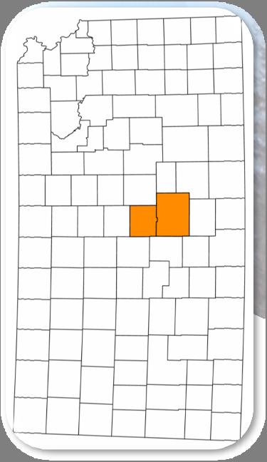
6 1.0 Executive Summary Figure 1-2. Map of K-96 Study Area 1.1 Introduction During meetings to update the Statewide Long Range Transportation Plan, participants identified the need for a four-lane highway between the Kansas cities of Nickerson and Sterling. In 2008, the Kansas Department of Transportation (KDOT) selected Wilson & Company, Inc., Engineers & Architects of Salina, Kansas, to conduct an engineering location study for this concept. An existing two-lane highway, K-96, connects Sterling and Nickerson to each other and also to the larger cities of Hutchison and Wichita to the southeast, as well as to Lyons and points west. The segment of K-96 connecting Sterling (2000 Census population 2,642) and Nickerson (population 1,194) is a paved, rural highway that does not meet modern design standards (see Figure 1-1). It follows a north/south alignment through Sterling and an east/west alignment into Nickerson for a total trip length of about 10.5 miles. By comparison, a straighter diagonal route connecting the cities would have the potential to cut up to three miles off of the existing K-96 distance. Figure 1-1. K-96, a rural 2-lane highway in south central Kansas 1.2 Study Limits and Goals The area encompassed by this location study begins southeast of Nickerson at Yaggy Road and existing K-96, and extends for 15 miles to the northwest, connecting with existing K-96/K-14 north of Sterling. The study examined a six-mile wide area, roughly centered on the existing highway and its hypothetical alignment if it continued to the northwest from Nickerson. The study area is shown in Figure 1-2. The goal of the study was to determine the location of a new highway corridor and determine the type of improvements needed to meet the long-term needs the highway must serve. The study examined feasible locations for a four-lane highway, including the possible upgrade of the existing two-lane to a four-lane on its current alignment. The study process utilized data from past studies and evaluated new data from a variety of sources. 1-1

7 1.3 Existing K-96 State Highway K-96 in south central Kansas is generally an east to west route, but through the study area connecting Nickerson and Sterling it includes segments running north/south, east/west and diagonally, as seen in Figure 1-3. It is part of the state highway system and is classified as a principal arterial by the Kansas Department of Transportation. Southeast of Nickerson, K-96 parallels the Kansas & Oklahoma (K&O) Railroad. The railroad continues northwest to Sterling (and beyond), but K-96 turns westward to a junction with State Highway 14, and continues northward to Sterling as both K-96 and K-14. Figure 1-3. Roads, Railroads, Rivers and Creeks in the K-96 Study Area highway other than resurfacing projects to maintain the condition of the pavement, plus the replacement of the two K-96 bridges over the Arkansas River. Since the 1990 s, the communities of Sterling and Nickerson have held discussions with KDOT about the prospect of building a four-lane highway between the two cities. During mid-2008, as part of this location study, approximately two dozen community leaders were contacted and asked to be interviewed about the K-96 Locations Study project. Potential interviewees were suggested by community leaders of Reno and Rice counties, KDOT, and those involved in previous K-96 corridor meetings. The interviewees included not only residents of Nickerson and Sterling, but also some from other parts of the greater K-96 corridor, including the cities of Hutchinson and Great Bend. As the result of this effort, 18 interviews were conducted. Each interviewee was asked the same set of questions and provided feedback on underlying issues and ways to provide effective communication within the surrounding communities. The section of K-96 between Nickerson and Sterling was constructed in the late 1950 s and early 1960 s. Sight distance is not a problem on this highway, which is relatively straight and flat, but the existing road is narrow and lacks shoulders in some areas. This route does not meet current design criteria for elements such as roadway width, ditch side slopes and curve geometrics. Since its initial construction, there have been no major upgrades or improvements made to the 1-2 The purpose of the community interviews was to gather information from technical experts, elected officials, and civic leaders to educate the study team of local issues and concerns to consider when determining the project corridor, and to help identify possible members for a project Community Advisory Group. For the most part, those interviewed were aware of the project and stressed the need for a new roadway serving the two communities. Input from these interviews and from the Community Advisory Group (CAG) was used to develop the project s purpose and need. In addition to the CAG, a Technical Advisory Group (TAC) was formed to assist the study team with technical data gathering. 1.4 Purpose and Need The purpose of the project is to create a safe and more efficient corridor with enhanced regional mobility that will also maintain or improve opportunities for economic vitality in the linked communities and the surrounding area. The need for a more efficient corridor arises from the fact that the existing route is circuitous and does not provide predictable travel times due to the locales through which it passes. The route passes through the communities of Nickerson and Sterling, taking 400 to 500 heavy trucks each day through downtown districts and past schools and residential areas. In Sterling, K-96 passes north/south through the entire town, including the downtown area, and skirts the campus of Sterling College at the north end of town. In addition, the existing route crosses the K & O Railroad tracks at-grade in both communities and thus is subject to motorist delays when trains pass through each city. Figure 1-4 shows the crossing in Sterling. Figure 1-4. View southbound on K-96 from downtown Sterling
8 Further travel unpredictability on K-96 results from occasional flooding, as the existing route crosses the Arkansas River twice (see Figure 1-3), as well as other drainages, and much of the route is located within the 100-year floodplain. Additionally, the particular location and design of the route makes it notably prone to major snow drifts in winter at the curve where the road changes from its orientation of east-west to north-south. Figure 1-5. K-96 Alternates Development and Screening Process From the community interviews it was learned that these problems cause local travelers to avoid use of K-96 and to instead use other local roads for their trip. Thus, the inefficiencies of the existing K-96 route impose an increased maintenance burden on local governments in the area. An improved corridor is needed not only to link the two cities more efficiently, but also to link them to the surrounding region. Previous studies have established a vision for K-96 to become an improved corridor linking Wichita and I-70. Whether or not that vision is ultimately realized, improvements to the corridor in the Nickerson to Sterling area would have independent utility by addressing inefficiencies that hamper both local and regional mobility in this area. As noted above, local input helped the study team identify priority needs that we used to select a preferred corridor for proposed improvements. Those needs are as follows: Provide safe and efficient regional travel and mobility Accommodate local and regional growth Accommodate oversized freight on non-local roadways Reduce regional and freight traffic flows/demands on locally owned and maintained roadways Provide predictable travel times for facility users, including emergency response vehicles Improve the highway s level of access control These needs are discussed further in Chapter 3 of this report. 1.5 Corridor Concepts In the concept development process, improvements to the existing K-96 route were determined to not meet the project purpose and need, which necessitated the identification of potential new corridor locations. Initially, six corridor routes were identified for consideration. Each route was split into two segments: Segment A, the northwestern half of the route including Sterling; and Segment B, the southeastern half of the route including Nickerson. Most of the alternates had a common junction in the middle, allowing various combinations of A-segment alternates with B-segment alternates. All alternates provided bypasses for both communities, developed to avoid substantial impacts to businesses and residents located adjacent to the existing highway. Corridor concepts considered can be found in Chapter 4. Early in the screening process, alternates were considered separately for segments A and B, in a mix-and-match approach. Once seven of the initial 11 segments had been screened out, the remaining segments were combined into specific combinations (e.g., A-4 with B-5). Later in the process, three additional alternates (AB-7, AB-8 and AB-9) were developed for consideration. Four of the combinations were screened out, leaving a final combination as the preferred alternate. A diagram outlining the process is provided in Figure Recommended Corridor and Highway Type Through a series of refinements and evaluations, a recommended corridor was developed by the study team. Public input from the Community Advisory Group and citizens helped to determine the 1,000 ft. corridor within which the proposed highway will be located. A general description of the recommended corridor location is shown below, following the corridor from southeast (Nickerson vicinity) to northwest (Sterling vicinity): The new route would diverge northward from existing K-96 at Yaggy Road. A grade-separated interchange at 56 th Avenue (RS 2026) would serve the Yaggy Road and Willowbrook areas and also provide a convenient route (RS 2026) to highway K-61 northeast of Hutchinson. A sideroad overpass (no access) would carry 82 nd Avenue (an east-west road) over the highway between Dean Road and Herren Road. North of 82 nd Avenue, the new route turns west. A grade-separated interchange with the north-south Nickerson Road (RS 560) would provide access for the city of Nickerson between 95 th Avenue and 108 th Avenue (Note: Existing K-96 would remain in place, usable as a local road from Nickerson Road to 56 th Avenue). 1-3
9 The route proceeds northwest, crossing over Avenue X with a sideroad underpass (20 th Road would become discontinuous, requiring a short jog onto Avenue X in order to continue north/south). The route proceeds northwest and a sideroad overpass would carry Avenue V over K-96 between 18 th Road and 19 th Road. The route proceeds westward and a sideroad overpass would carry 17 th Road over K-96 between Avenue V and Avenue U. At the K&O Railroad, a mainline overpass would carry K-96 over the railroad tracks. The route proceeds westward to a grade-separated interchange slightly north and east of Sterling, just south of Avenue U, between existing K-96 and 16 th Road. The route continues north to tie into existing K-96 just south of Avenue T. In the vicinity of the new Sterling interchange (two details above), a new local road would connect existing K-96 and 16 th Road. Avenue U would become discontinuous, tying into the new connector road on each side of the Sterling interchange. Figure 1-6 presents the location of the recommended corridor, interchanges, overpasses and underpass. Figure 1-6. Recommended Corridor Location and Key Features The recommended highway type is a four-lane divided highway with access provided only at grade-separated interchanges, consistent with a freeway design. Access Points It was noted above that the existing K-96 would remain in place, open for use as a locally maintained road. Constructing the new K-96 facility will add a new, safe and faster route for trips between Nickerson and Sterling and other cities beyond. The route description above indicated there would be three grade-separated interchanges providing access for motorists to enter or exit the new highway. These are: In Reno County, at 56 th Avenue (RS 2026) serving the Yaggy Road and Willowbrook areas In Reno County, immediately north of Nickerson In Rice County, northeast of Sterling, west of the intersection of 16 th Road and Avenue U Overpass and Underpass Locations Opportunities to cross, but not enter or exit the highway would be located as follows: In Reno County, about two miles east of Nickerson, 82 nd Avenue (RS 673) would cross over the new K-96 highway In Rice County, between Nickerson and Sterling, the new K-96 would cross over Avenue X, a local east-west road In Rice County, about 2.5 miles east of Sterling, Avenue V (RS 572) would cross over the new K-96 highway In Rice County, about 1.5 miles northeast of Sterling, 17 th Road would cross over the new K-96 highway The interchanges and overpass/underpass locations recommended for the project are the only places where local traffic could cross the new highway. These locations are at reasonable intervals to minimize disruption to local traffic and also to provide connection to key routes in the area. There are a total of seven crossing locations available over the length of the new highway corridor. 1-4
10 1.7 Summary of Public Involvement Public comment and participation played a key role in determining the recommended corridor and highway type. The public s input was solicited in a number of ways including: Interviews with community leaders (18 conducted) Community Advisory Group (5 meetings) Technical Advisory Committee Project website Media releases Public information meetings (2 held) A detailed summary of public involvement activities can be found in Chapter Estimated Project Costs The total estimated cost of the project is shown in Table 1-1, broken into two individual project segments, corresponding to the portions within each county. Upon determination of a preferred alternative, the estimated project costs were further defined to establish budget level cost estimates for project programming purposes. County Table 1-2. Project Cost Summary 2-Lane on 4-Lane Right of Way ($ millions) Preliminary Engineering Construction Engineering Right-of- Way Utility Adjustments Construction Total Costs Reno $2.424 $3.422 $3.590 $3.517 $ $ Rice $2.728 $3.851 $3.135 $2.655 $ $ Totals $5.152 $7.273 $6.725 $6.172 $ $ Note: All costs are expressed in fiscal year (FY) 2010 dollars. The cost estimates discussed above are not separately detailed in a later chapter of this report, but are available as internal KDOT administrative documentation if needed. Construction costs include necessary work to build the four-lane freeway. Also included are the estimated costs for rehabilitation work on the portions of existing K-96 that will be relinquished to the respective counties. County Table 1-1. Project Cost Summary Four-Lane Access Controlled Freeway ($ millions) Preliminary Engineering Construction Engineering Right-of- Way Utility Adjustments Construction Total Costs Reno $3.514 $4.961 $3.590 $3.517 $ $ Rice $4.069 $5.745 $3.135 $2.655 $ $ Totals $7.583 $ $6.725 $6.172 $ $ Note: All costs are expressed in fiscal year (FY) 2010 dollars. Depending on future conditions including growth, traffic demand and funding availability, there is potential for the project to be constructed in an interim condition that would operate two traffic lanes (one in each direction) within a corridor for which design and right-of-way provide for future completion of four traffic lanes (two in each direction). Because there are many cost elements (design, right-of-way, utility adjustments and some bridges) which must be completed for the ultimate project in order to accommodate the interim condition, the costs of the two on four interim condition typically comprise much more than half of the ultimate project total. Estimated costs for the phased construction approach are shown in Table


11 2.0 Project Description Figure 2-2. K-96 north of Sterling (view to the south) 2.1 Background K-96 Highway is a west to east roadway connecting Sterling to Nickerson in south central Kansas, as shown in Figure 2-1. It is part of the state highway system and is classified as a principal arterial by the Kansas Department of Transportation. Figure 2-1. Select Kansas Highways The portion of K-96 within the study area contains both rural and urban roadways, eastwest and north-south segments, and a northwest to southeast diagonal section that parallels the Kansas & Oklahoma Railroad. In the rural areas, there are intersections at junctions with county and local roadways, and dozens of private entrances that directly access the highway. There are two at-grade rail crossings, one in Sterling and the other in Nickerson. Figure 2-3. K-96 between Sterling and Nickerson (view to the east) The existing roadway was constructed in the late 1950 s and early 1960 s. Outside Nickerson and Sterling, the existing road is a rural, two-lane highway. Inside the city limits, the existing roadway includes both curb & gutter and open ditch sections, with on-street parking in some areas. The current route passes through the business areas of both towns. Sterling College and Nickerson High School are immediately adjacent to the highway in their respective communities. This route does not meet current design criteria for elements such as roadway width, ditch side slopes and horizontal curve geometrics. Since its initial construction, there have been no major upgrades or improvements made to the roadway other than resurfacing projects to maintain the condition of the pavement. Both bridges over the Arkansas River between Sterling and Nickerson were replaced in the mid 1990 s. Figure 2-4. K-96 southeast of Nickerson (view to northwest) North of Sterling, the existing roadway is comprised of two -12 driving lanes with 6 wide composite shoulders comprised of bituminous surfacing and turf. This portion of the corridor is depicted in Figure 2-2. Between Sterling and Nickerson, the roadway is subject to flooding in low areas and closures in the winter due to snow drifting. As shown in Figure 2-3, this section of K-96 has narrow to no shoulders and minimal right-of-way. The most modern section of the existing road is located southeast of Nickerson, shown in Figure 2-4. Once outside the city limits, the roadway is straight with minimal vertical relief, and relatively 2-1


 conducted by KDOT in 2008 and 2009, locally held public forums generated comments further outlining the public s desire to improve K-96")


12 wide right-of-way. This portion of K-96 is orientated on a northwest to southeast diagonal, and parallels the northeast side of the Kansas and Oklahoma Railroad. As such, there are numerous intersections with county and local roads with severely skewed angles of intersection, typically at 40 to 50 degrees. Figure 2-5. Study Area for K-96 Location Study 2.2 Project Initiatives Upgrades to the highway have been discussed for over two decades. This portion of K-96 was included in the 1986 Western Kansas Turnpike/Freeway Feasibility Study completed by HNTB that looked at routes from Hays to Wichita. In 1999, the Northwest Passage Corridor Location Study was completed by HNTB that evaluated potential locations for improvements to K-96 from Great Bend to Hutchinson. That study was used to prepare a System Enhancement Program application that was submitted to KDOT for the same section of K-96 that this present study is evaluating. The application was for a four-lane, partially access controlled highway. Both previous studies identified the needs and desires for improved transportation capabilities in the area. During development of the Long Range Transportation Plan (LRTP) conducted by KDOT in 2008 and 2009, locally held public forums generated comments further outlining the public s desire to improve K-96 from Great Bend to Hutchinson. 2.3 Study Limits and Goals The area encompassed by the study begins southeast of Nickerson, then continues northwesterly for approximately 15 miles to north of Sterling. The study examined a six-mile wide area roughly centered on a diagonal line extended through the communities of Nickerson and Sterling. This area is shown in Figure 2-5. K-96 joins US 56 at Lyons and continues westward to Great Bend. The study area does not include all of existing K-96 (e.g., west of Nickerson and south of Sterling) for reasons that are explained in Chapter 4. The primary goal of the study was to develop the alignment of a preferred corridor for improvements to K-96. The location study developed and examined feasible locations for a fourlane highway. A range of alternatives were analyzed including the No Build or do nothing alternate, along with several new corridor alignments. Since all of the alternatives except the No Build option involved new alignments, primary components of the alternate evaluations included identification of appropriate bypasses around established communities, and the location of appropriate locations for access to the highway. The goal of the study was to develop the most feasible location for the highway. Each alternative was evaluated on the basis of safety, traffic patterns, capacity, social and environmental concerns, and cost. After receiving input from the general public, affected governmental agencies and the Community Advisory Group, KDOT selected the final corridor location and the appropriate design type to serve the traffic needs. 2-2
13 3.0 Project Purpose and Need 3.1 General Study Limits and Goals Because K-96 was built more than half a century ago, it is not surprising that portions of the existing highway do not meet current design criteria for vertical and horizontal alignment. Other concerns about the existing highway are that it does not provide a direct route between Nickerson and Sterling, passes through each city, has two at-grade railroad crossings, crosses the Arkansas River twice and is largely located within the 100-year floodplain. Flooding on K-96 and snowdrifts west of the K-14 junction occur often enough to diminish the reliability of the existing route, resulting in use of alternate routes during these conditions. Figure 3-1. FY 2009 Daily Traffic Volumes on K-96 and Connecting Major Collectors 3.2 Accident Experience For the five years from 2005 to 2009, there was an average of approximately 39 crashes per year along the stretch of K-96 between 1.4 miles north of Nickerson and 4.3 miles southeast of Nickerson. On average, there have been about seven injury accidents annually, resulting in about 1.5 persons injured per incident. These statistics encompass a total of 197 accidents over the five-year period, including one human fatality. The most common type of accident was collision with an animal as these totaled 94 (48%) of the accidents. Many of these collisions involved deer. Another 21% of the accidents were collisions with other vehicles, and 13% were collisions with fixed objects. Based on these data, the overall weighted accident rate for the highway (per million miles of travel) was 2.08, which is higher than the 1.54 average for similar roadway types statewide. Future traffic growth (K-96 volumes are expected to more than double by 2035) will increase the number of travelers exposed to the risks associated with the existing highway location and design. 3.3 Existing Traffic Traffic volumes on K-96 and connecting major collector roads are shown in Figure 3-1. Traffic in the study area is highest on K-96 north of Sterling and southeast of Nickerson, where volumes range from about 4,560 to 3,850 vehicles per day, respectively. Heavy commercial truck volumes range from 375 per day north of Sterling to 485 trucks per day south of Nickerson, and make up 12 to 14 percent of the total traffic within the corridor. The traffic volumes on K-96 are lower between Nickerson and Sterling than either north or south of these communities. This is a result of drivers familiar with the area using county collector roads RS 560 and RS 572 as an alternate route. This pseudo by-pass route avoids Sterling and thus has less delay for through traffic. Therefore, the actual travel demand for the K-96 corridor between Nickerson and Sterling is higher than that indicated by existing traffic volumes on K-96 alone. Only a modest amount of traffic, 455 vehicles per day, on K-96 is associated with state highway K-14 which joins the corridor from the south. 3.4 Roadway Geometrics Throughout the corridor, the composite bituminous/turf shoulders do not provide sufficient paved shoulder width to accommodate stopped vehicles, recovery from emergency maneuvers, or traffic enforcement operations. At numerous locations within the project corridor, sideroads intersect K-96 at angles significantly less than right angles. For intersection safety, it is preferred that intersecting roads come in at or near a 90-degree angle. As the angle of intersection decreases from the preferred right angle, the visibility of oncoming traffic to the driver entering from the sideroad is increasingly diminished. 3.5 Accommodation of Future Growth In the future, traffic in the K-96 corridor is expected to increase substantially. By 2015, KDOT forecasts traffic at either end of this corridor to be in the range of 5,600 to 5,700 vehicles per day, and by the 2035 design year, the range would be 8,600 to 8,700. These future volumes are more than double the 3,600 to 3,900 for the current, baseline conditions. The projected 2035 volumes, particularly when considering the high percentage of heavy trucks, would greatly tax the capacity of K-96 as a 2-lane roadway. 3-1
14 Increased traffic volumes in the future have the potential to accentuate existing safety hazards associated with the highway s many access points serving adjacent land. By 2035, traffic between the two cities will increase to a similar degree. If the additional traffic between the cities is distributed on the state highway and the county collectors as occurs currently, this would clearly place an increased traffic burden on the county roads. 3.6 Economic Vitality The forecasted traffic increase in the K-96 corridor is not due to projected growth in Sterling or Nickerson, but instead due to continued growth in statewide travel. Estimates released by the State Data Center of Kansas in June 2010 indicate that both cities declined in population by approximately 4% between the 2000 Census and July 1, The estimated decline was 106 residents in Sterling and 47 residents in Nickerson. Looking to the future, the K-96 corridor is part of an overall route between Hutchison and Great Bend, which in turn connects Wichita with I-70. Travel demand for this route has the potential to bring additional commerce to the study area, if the highway provides an adequate level of safety and mobility to attract such trips. The existing highway does not offer these characteristics. 3.7 Project Purpose The purpose of the project is to create a safe and more efficient highway corridor with enhanced regional mobility that will also maintain or improve opportunities for economic vitality in the linked communities and the surrounding area. As noted above, local input helped the study team identify priority needs that we used to select a preferred corridor for proposed improvements. Those needs are as follows: Provide safe and efficient regional travel and mobility Accommodate local and regional growth Accommodate oversized freight on non-local roadways Reduce regional and freight traffic flows/demands on locally owned and maintained roadways Provide predictable travel times for facility users, including emergency responders Improve the highway s level of access control 3.9 Conclusion The existing, outdated K-96 was adequate to carry low volumes of traffic more than half a century ago, but is not configured to meet the growing demands that are being placed on it in the 21 st century. Evaluation of various alternatives will establish the specific improvements, which satisfy the purpose and need at an acceptable cost, and at an acceptable level of impact to the environment and adjacent communities. 3.8 Project Need The need for a more efficient corridor arises from the fact that the existing route is circuitous, unreliable, and does not provide predictable travel times. The route passes through the communities of Nickerson and Sterling, taking about 400 heavy trucks each day through downtown districts and past schools and residential areas. In Sterling, K-96 passes north/south through the entire town, including the downtown area, and skirts the campus of Sterling College at the north end of town. In addition, the existing route crosses the K & O Railroad tracks at-grade in both communities and thus is subject to motorist delays when trains pass through each city. Further travel unpredictability on K-96 results from occasional flooding, as the existing route crosses the Arkansas River twice, as well as other drainages. Much of the route is located within the 100-year floodplain. Additionally, the particular location and design of the route makes it notably prone to major snow drifts in winter at the curve west of the junction with K-14, where the road changes from its orientation from east-west to north-south. These reliability issues degrade the highway s ability to handle emergency response traffic. Community interviews indicated that these reliability problems cause local travelers to avoid using K-96 and to instead use other local roads for their trip. Thus, the inefficiencies of the existing K-96 route impose an increased maintenance burden on local governments in the area. An improved corridor is needed not only to link the two cities more efficiently, but also to link them to the surrounding region. Previous studies have established a vision for K-96 to become an improved corridor linking Wichita and I-70. Whether or not that vision is ultimately realized, improvements to the corridor in the Nickerson to Sterling area would have independent utility by addressing inefficiencies that hamper both local and regional mobility in this area. 3-2
15 4.0 Concept Development and Evaluation 4.1 Type of Highways Considered No Build Alternative An evaluation of the existing highway, or No Build alternative, was considered but was omitted from the decision matrices due to deficiencies with regards to traffic and safety, and the desire to move highway traffic, particularly truck traffic, from the downtown areas of both Nickerson and Sterling. The desire for a safer and more efficient route, and capacity improvements to accommodate the projected growth in traffic volumes indicated that improvements were necessary for the highway to operate at Level of Service (LOS) B or better in the design year, which is a standard goal for highway improvements in a rural area. Further details on current and projected traffic volumes and related considerations can be found in Appendix A. The No Build alternative does not address the geometric shortcomings and the need for modernization of the present alignment of K-96. The existing highway cannot be upgraded along its present route through the communities of Sterling and Nickerson without an unacceptable level of impacts. It has been noted earlier that the existing alignment passes through both cities and twice crosses the Arkansas River and its associated wetlands. Additionally, a large number of properties currently have direct access to K-96, so even between the cities, major roadway improvements on the existing alignment would have major adverse effects on accessibility. Since the existing two-lane facility (the No Build option) will not satisfy future traffic capacity or safety considerations in a safe and efficient manner, it did not satisfy the purpose and need for the project. While the No Build Alternative would not meet the project s purpose and need, nevertheless it is a scenario that is required to be considered in the environmental process in accordance with regulations of the National Council on Environmental Quality. The No Build alternative provides a clear basis for environmental impacts comparison with one or more proposed new alternates Four-Lane Divided Highway Improvement options considered for this study consisted of a four-lane divided highway, with full access control, and an intermediate or phased approach to the improvements, consisting of a twolane highway on right-of-way sufficient for a future four-lane. Access to and from the highway would be provided only at grade separated interchange locations. Any existing local roads that are proposed to cross the highway would do so via grade separations (overpasses or underpasses). All other local roads would be re-routed or closed. 4.2 Design Criteria Generalized design criteria were established to aid in development and evaluation of corridor alternatives. These are detailed in Table 4-1. Since a two-lane highway would not provide sufficient capacity to handle the design year traffic, design criteria were established for only a four-lane highway. Table 4-1. Design Criteria for K-96 Roadway Alternates Design Features Design Criteria General Route Classification C Functional Classification Principal Arterial Lane Class 4 Lane Divided, or 2-Lane on 4-Lane R/W Access Control Full AADT (Year 2015) 4,500 to 5,700 AADT (Year 2035) 7,000 to 8,700 Mainline Rural Section Geometrics Design Speed Clear Zone Distance (6:1) Minimum Roadway Width 40 Lane Width 12 Shoulder Width Inside (Paved) 6 Outside (Paved) 10 Median Width 60 Minimum Side Slopes Inside Clear Zone 6:1 Fills up to 30 ft. 6:1, 4:1 Fills over 30 ft. 6:1, 4:1, 3:1 75 mph Desired 30 to 34 ft. (Pg.3-6, Roadside Design Guide) Standard Ditch 10 x 3-6 Ditch Backslopes 4:1 (3:1 over 20 high) Pavement Cross Slopes 1.6%, 4.2% Minimum Horizontal Curve 3,620 Desired, 2,210 Minimum Mainline Maximum Super-elevation Rate 6.0% Desired, 8>0% Maximum Maximum Longitudinal Grade 3% Minimum Stopping Sight Distance (Vertical) 820 Minimum Vertical Clearance Sideroad Over 16-4 Interchange/Major Sideroad Under 16-4 Minor Sideroad Under 15-4 Railway Separation 23-6 Bridges Roadway Width 40 Loading LRFD HL-93 Hydraulics Recurrence Interval Mainline 50 Year Recurrence Interval Interchanges 25 Year Recurrence Interval Major Sideroads 25 Year Recurrence Interval Minor Sideroads & Local Roads 10 Year 4-1
16 Design criteria were also developed to address improvements necessary to the local road system, which ranged from paved county arterials to local roads. The generalized design criteria used for local roadway system improvements is in Table 4-2. Table 4-2. Design Criteria for Local Road System Design Features Design Criteria Major Sideroads AADT 1,501 to 2,000 Design Speed 50 mph (Table VI.1A, BLP Design Manual) Clear Zone Distance 26 to 32 (Pg. 3-6 Roadside Design Guide) Stopping Sight Distance 425 Width of Traveled Way 24 Shoulder Width 6 Side Slopes 6:1 Inside Clear Zone, 4:1 Ditch Backslopes 4:1 Standard Ditch 10 x 3 Maximum Longitudinal Grade 6.0% Bridge Width Initial Corridor Development Initially, six primary corridor routes were identified for consideration. Corridor locations and layouts were developed after a review of prior studies and in conjunction with an initial evaluation of potential environmental impacts. The initial corridors developed for consideration were all on new alignments, although two of the alternates paralleled a portion of existing K-96 highway between Nickerson and Hutchinson. These corridors are shown on Figure 4-1, and are divided into A or B segments. Each of the concepts shown represents a corridor of 1,000 feet in width. Figure 4-1. Map of Initial Corridor Alternates Sideroads AADT 401 to 1,500 Design Speed 50 mph (Table VI.2A, BLP Design Manual) Clear Zone Distance 16 to 20 (Pg. 3-6 Roadside Design Guide) Stopping Sight Distance 425 Width of Traveled Way 24 Shoulder Width 6 Side Slopes 4:1 Ditch Backslopes 3:1 Standard Ditch 8 x 2-6 Maximum Longitudinal Grade 6.0% Bridge Width 36 Minor Sideroads AADT 251 to 400 Design Speed 40 mph (Table VI.2A, BLP Design Manual) Clear Zone Distance 16 to 20 (Pg. 3-6 Roadside Design Guide) Stopping Sight Distance 305 Width of Traveled Way 24 Shoulder Width 2 Side Slopes 4:1 Ditch Backslopes 3:1 Standard Ditch 8 x 2 Maximum Longitudinal Grade 7.0% Bridge Width 28 Note follow KDOT Bureau of Design Standards for Sideroad Improvements Immediately Adjacent to K
17 All of the corridors are located to the east and north of Sterling and Nickerson. Corridors located to the south and west, including the existing alignment, were dropped from consideration since they would require crossing both the railroad and the Arkansas River at two or more locations. In addition, considerable impacts would be encountered with respect to wetlands, floodplains, potential archeological sites and critical habitat for wildlife. Five of the six alternates tie into existing K-96 highway at approximately the same location north of Sterling, roughly one mile north of the city limits. Alternate A-6 ties into the existing K-96 alignment approximately three miles north of the city limits. At the west end of the corridor, alternates A-1 through A-5 were developed to allow the flexibility for future extension of the corridor to continue either west or north with minimal realignment/reconstruction. Each of the alternates cross the Kansas & Oklahoma (K&O) Railroad tracks northeast of Nickerson, and all cross one of the major county arterial roads, Avenue V, although at varying locations. At the east end of the corridor, all the B segment alternates tie into the recently completed K-96 bypass (i.e., the highway continuing southeast to Hutchinson) at the same location, approximately at the intersection of K-96 and Yaggy Road. Description of Initial Segment A Alternates The location and layout of A-1 closely follows the corridor alignment recommended in the 1999 Northwest Passage Corridor Location Study. This alternate is located the closest to Sterling, passing around the north and east limits of the community at a distance of one-half mile or less. Southeast of Sterling, the corridor parallels the K&O Railroad tracks. Alternate A-2 is very similar to A-1, but is located further to the east of Sterling to allow the use of a flatter horizontal curve to obtain more distance from the railroad tracks and to avoid impacts with the city s wastewater lagoons, which are located in the southeast corner of the community. Alternates A-3 and A-4 are very similar, with the main difference in the layouts consisting of how each corridor avoids impacts to a major utility. Alternate A-3 passes to the south of the natural gas pumping facility located at the intersection of Avenue W and 18 th Road, while A-4 passes to the north. Both are located over a mile east of the city limits of Sterling. The layout of Alternate A-5 was developed to provide more desirable angles of crossing with both the K&O Railroad and Avenue V. This alternate is located further east of Sterling than the previously described alternates, and passes to the north and east of the cluster of irrigated farmland tracts located to the east of Sterling. Alternate A-6 was developed to lessen impacts on irrigated land, avoid the major underground utility lines located north of the railroad, and to provide a more direct connection between Lyons and Hutchinson. This alternate crosses Avenue V approximately three miles east of the city limits and ties into existing K-96 3 miles north of the city limits. Description of Initial Segment B Alternates Alternate B-1 is a continuation of the recommended alignment included in the1999 Northwest Passage Corridor Location Study. It skirts the north and east sides of Nickerson within one half mile of the city limits. Southeast of Nickerson, the corridor parallels existing K-96 to Yaggy Road. Alternate B-2 is similar to B-1, but is located further away from the city to lessen floodplain impacts and crosses 82 nd Avenue and Bull Creek at closer to a 90 degree angle than Alternate B-1. This alternate also parallels the K&O Railroad and existing K-96 for a portion of the route. Alternates B-3 and B-5 (there was no B-4 developed) are similar in many aspects. The major differences between the two alternates are which side of existing residences east and north of Nickerson they pass by, the sharpness of the horizontal curve east of Nickerson, and the angle of intersection with the two major county arterial roads serving Nickerson, 82 nd Avenue and Nickerson Road. Alternate B-5 crosses both at much closer to 90 degrees than does Alternate B-3. As in the A segment, Alternate B-6 is located significantly further to the north and east of the other alternates. It crosses 82 nd Avenue in the same general vicinity as Alternates B-3 and B-5, but continues on more of a northwest diagonal direction from that point than all the other alternates. It crosses Nickerson Road approximately two miles north of the Nickerson city limits. 4.4 Initial Corridor Screening Preliminary corridor screenings involved the comparison of several factors identified as key concerns by the public through community interviews and as voiced by the Community Advisory Group (CAG) at the first meeting held on July 31, While numerous concerns were expressed related to location of the proposed highway, the CAG continued to stress the public s desire for the project team to place a high importance on the location of the corridor and how access would be provided to both the Nickerson and Sterling communities, while balancing the impacts on both the rural and urban areas. Based on these concerns, the following factors were used for comparing the initial corridor alternatives: Overall corridor length, in miles Number of horizontal curves Number of Rural Secondary routes and railroad tracks intersected at angles less than 75º Number of potential relocations Number of Irrigation Wells and Center Pivots Impacted Range of corridor proximity to Sterling and Nickerson, in miles Number of Major Utility Crossings, length of impact, and qualitative degree of impact Amount of floodplain acres impacted The goal was to minimize all of these impacts. Typically, no single alternative minimizes all adverse effects, so the comparison process eventually requires consideration of tradeoffs. Table 4-3 presents the data for each segment with regard to the criteria listed above. 4-3
18 Evaluation Criterion Table 4-3. Comparison of Preliminary Alternates for Initial Screening Segment A Corridors Segment B Corridors A-1 A-2 A-3 A-4 A-5 A-6 B-1 B-2 B-3 B-5 B-6 Overall Corridor Length (miles) No. of Horizontal Curves No. of RS Routes and RR crossings with intersection angles less than 75 degrees No. of Potential Relocations Adjacent Homes with Acreages Impacted No. of Irrigation Wells Impacted No. of Center Pivots Impacted Range of Corridor Proximity to Sterling 0.4 N 0.4 N 0.4 N 0.4 N 0.4 N 3.1 N 0.4 N 0.6 N 0.6 N 0.7 N 2.0 N or Nickerson (miles) [and direction] 0.5 E 0.6 E 0.8 E 1.3 E 1.8 E 3.3 E 0.5 E 1.1 E 1.6 E 2.0 E 2.2 E No. of Major Utility Crossings * 8* 8* 10 7 Length of Major Utility Impacts (feet) 5,600 6,240 6,590 11,740 9,050 6,210 17,690 23,370 30,300 20,790 20,570 Utility Impact Severity (high/ medium/ low) low low low medium medium medium high high high medium medium No. of Floodplain Acres Impacted none none none none none none * Impacts the Nickerson Gate Valve T-1A (VS-21), owned by Black Hills Energy, at 95 th Avenue and Riverton Road At the October 30, 2008 CAG meeting, the initial corridor alternatives were presented and the comparisons between alternates discussed. A detailed summary of the CAG meeting is included in the Public Involvement Activities Log, but the key points and outcome of the discussions are listed below. Segment A Corridors Alternatives A-1 and A-6 were dropped from further consideration. Alternate A-1 was deemed too close to town to allow for much growth, and it would impact the recently expanded wastewater lagoon facility southeast of Sterling. Alternate A-6 was determined to be located too far away from Sterling to allow for effective access. Alternates A-2, A-3, A-4 and A-5 were retained for further evaluation. It was suggested to look at a combination of A-5 and A-6 to retain the tie in with K-96 three miles north of Sterling but cross Avenue V closer to town as shown on A-5. Segment B Corridors Alternate B-1 was determined to be too close to Nickerson to allow for future growth and crossed a wide area of the Bull Creek floodplain. The portion of Alternate B-1 that paralleled existing K-96 resulted in a high number of residential relocations as well. Both Alternates B-1 and B-2 posed some difficulties in laying out an acceptable interchange configuration at the junction with 56 th Avenue. Like its A segment counterpart, Alternate B-6 was deemed too far away from Nickerson to provide efficient access and accommodate growth. Alternates B-3 and B-5 were retained for further consideration, and the suggestion was made to look at a hybrid of B-2, B-3 and B-5 that would reduce the impacts on irrigated farm ground in the area north and east of Nickerson. Other Evaluation Comments Looking at the route as a whole, the recommendation was made to look at combining segments A-4 and B-3. As a general comment, the suggestion was made to look at ways to make minor changes to the remaining alternatives to lessen impacts on irrigated farmground. 4.5 Second-Level Corridor Screening Based upon the comments and suggestions received from the initial screening effort, the remaining alternates were reviewed more closely and additional information was developed about them. This information was presented at a CAG meeting on February 26, Table 4-4 reflects the revised information that was considered in February, which included new criteria such as wetland impacts and number of frontage road miles needed. As the initial corridors had been adjusted slightly in various locations, some of the data from the initial screening had changed (e.g., corridor lengths, number of center pivots, etc.). 4-4
19 Table 4-4. Comparison of Preliminary Alternates for Second-Level Screening Evaluation Criterion Segment A Corridors Segment B Corridors A-2 A-3 A-4 A-5 B-2 B-3 B-5 Overall Corridor Length (miles) No. of Horizontal Curves No. of Access or Frontage Roads Needed Length (miles) of Access of Frontage Roads Needed No. of Local Road Closures No. of Acres needed for right-of-way (approx.) No. of Farmland Tracts Bisected by Corridor No. of Residences within Corridor No. of Adjacent Homes with Acreages Impacted No. of Irrigation Wells Impacted No. of Center Pivots Impacted No. of Major Utility Crossings Length of Major Utility Impacts (feet) 6,600 7,500 12,300 16,600 20,400 22,200 19,700 Utility Impact Severity (high/ medium/ low) low low medium medium medium high high No. of Wetlands Impacted No. of Wetland Acres Impacted No. of Floodplain Acres Impacted none none none none Distance (miles) from City Limits to New K-96 Highway Access Location and Direction 0.7 North Access to Communities (positive/negative) No. of Additional K-96 Turnback Miles (Sterling North, Nickerson SE to 56 th Ave.) Economic Development Potential (positive, neutral, or negative) Approximate Project Cost in Millions of Current Year Dollars North North East North North North On the basis of this further screening, Alternates A-2, A-5 and B-2 were dropped from further consideration, for the following reasons: Alternate A-2 was dropped due to a combination of factors, including its residential impacts and its proximity to the railroad (limiting economic development potential) Alternate A-5 was dropped because its highway access point was too far from Sterling, resulting in adverse economic development potential Alternate B-2 was dropped primarily due to its extensive residential impacts. Thus, the result of the first two rounds of screening was that four corridor segments remained for presentation at a public meeting that was scheduled for May These four alternates were A-3, A-4, B-3 and B-5. At the May 2009 public meeting (discussed further in Chapter 7), comments about these alternates were received, as well as comments and suggestions that resulted in the addition of two new alternates (AB-7 and AB-8) for further consideration. 4-5

 A new alternate AB-7, farther east, was developed (shown in orange) A new alternate AB-8, much farther east, was developed (shown in green) A general description of each corridor alternative")
 between Herren Road and Dean Road and proceeds to the northwest.")

 between Herren Road and Dean Road and proceeds to the north, turning westward just north of 95 th Avenue and Herren Road.")
.")
20 4.6 Third-Level Screening of Alternates Figure 4-2 illustrates the alternates that were considered in the third round of screening, and indicates how they fared in the process. At this stage of the analysis, based on public input, the A segments and B segments that had survived the first two screening steps were merged into combinations as follows: Figure 4-2. Alternates Considered in Third-Level Screening Segments A-3 and B-3 were merged to form the combination A-3/B-3 (shown in red) Segments A-4 and B-5 were merged to form the combination A-4/B5 (shown in pink) A new alternate AB-7, farther east, was developed (shown in orange) A new alternate AB-8, much farther east, was developed (shown in green) A general description of each corridor alternative is also listed below. Alternate A-3/B-3 (shown in red): At the south end, departs from existing K-96 in the vicinity of Yaggy Road. Crosses 82 nd Avenue (sideroad overpass) between Herren Road and Dean Road and proceeds to the northwest. Has an interchange serving Nickerson on Nickerson Road about midway between 95 th Avenue and 108 th Avenue. Closely parallels the K& O Railroad for about three miles. Continues to the northwest, crossing Avenue V in the vicinity of 17 th Road. Has an interchange serving Sterling near 16 th Road and Avenue U. Ties into existing K-96 just south of Avenue T. Alternate A-4/B-5 (shown in pink): At the south end, departs from existing K-96 in the vicinity of Yaggy Road (same as Alternate A-3/B-3). Crosses 82 nd Avenue (sideroad overpass) between Herren Road and Dean Road and proceeds to the north, turning westward just north of 95 th Avenue and Herren Road. Has an interchange serving Nickerson on Nickerson Road about midway between 95 th Avenue and 108 th Avenue. Closely parallels the K& O Railroad for about three miles (same as Alternate A-3/B-3). Continues to the north/northwest, with a sideroad overpass at Avenue V between 17 th Road and 18 th Road. Has an interchange serving Sterling near 16 th Road and Avenue U (same as Alternate A-3/B- 3). Ties into existing K-96 just south of Avenue T (same as Alternate A-3/B-3). Alternate AB-7 (shown in orange): At the south end, departs from existing K-96 in the vicinity of Yaggy Road (same as Alternate A-3/B-3). Crosses 82 nd Avenue (sideroad overpass) between Herren Road and Dean Road and proceeds to the north, turning northwest at the county line (intersection of 24 th Road and Avenue Y). Has an interchange serving Nickerson on 22 nd Road at Avenue X. Continues to the northwest by west, with a sideroad overpass for 20 th Road at Avenue W, and a sideroad overpass at Avenue V between 17 th Road and 18 th Road. 4-6
21 Has an interchange serving Sterling near 16 th Road and Avenue U. Ties into existing K-96 just south of Avenue T. Alternate AB-8 (shown in green): At the south end, departs from existing K-96 in the vicinity of Yaggy Road (same as Alternate A-3/B-3). Crosses 82 nd Avenue (sideroad overpass) between Herren Road and Dean Road and proceeds to the north, turning northwest by north at 95 th Avenue. Has an interchange serving Nickerson southwest of the existing intersection of 22 nd Road and Avenue V (RS 560 and RS 572). Continues northwest to 18 th Road, between Avenue S and Avenue R, then turns to the west. Crosses the K& O railroad and turns north to tie into existing K-96 at Avenue Q. An interchange at the Avenue Q tie-in location would serve Sterling. Table 4-5 compares these alternates based on the previously established evaluation criteria. It should be noted that the numbers in the table now represent entire corridors, not just partial A or B segments. For example, where the right-of-way impacts for Alternates A-3 and B-3 previously were reported as 357 acres and 452 acres, respectively, the impact shown for the combined A-3/B-3 corridor is their sum, 809 acres. The two new alternates, AB-7 and AB-8 had been developed in response to public input, partly for the purpose of avoiding impacts to agricultural operations (irrigation wells and center pivots) that are close to the towns, but the tradeoff for this avoidance was a dramatic increase in the distance from each city to its nearest new K-96 access. Whereas that distance for each community was approximately 0.7 mile for alternates A-3/B-3 and A4/B-5, it jumped to 2.2 miles for Nickerson with alternate AB-7, and to more than four miles for each city with alternate AB-8. While minimization of adverse impacts to farming was an important goal in the study, at the same time it is critical to keep the highway close enough to each city so that commercial traffic would not bypass these cities altogether. The new route should provide mobility and economic benefits not only to regional travelers, but also to the communities along the existing route. Thus in the third level of screening, conducted by the CAG and the TAC in August 2009, the two newly added alternates were considered but were eliminated from further consideration, as is indicated in Figure 4-2. Also eliminated at this stage was alternate A-4/B-5. Comparing A-4/B-5 to A-3/B-3 (better), the two are very similar but some key differences favored the latter. For alternate A-3/B-3, the corridor length was shorter, there were fewer horizontal curves (a safety consideration), less right-of-way would be needed, fewer wetlands impacted, and there would be fewer major utility impacts. Combined, these advantages were the reason for eliminating alternate A-4/B-5. Table 4-5. Comparison of Combined Alternates Evaluation Criterion A-3/B-3 A-4/B-5 AB-7 AB-8 Overall Corridor Length (miles) Number of Horizontal Curves No. of Access or Frontage Roads Needed No. of Miles of Access of Frontage Roads Needed No. of Local Road Closures No. of Acres needed for right-of-way (approx.) No. of Farmland Tracts Bisected by Corridor No. of Residences within Corridor No. of Adjacent Homes with Acreages Impacted No. of Irrigation Wells Impacted No. of Center Pivots Impacted 50% or more No. of Center Pivots Impacted less than 50% No. of Major Utility Crossings Length of Major Utility Impacts (feet) 35,300 40,100 23,200 19,800 Impacts Airstrip Operation (yes or no) yes no no No No. of Wetlands Impacted No. of Wetland Acres Impacted No. of Floodplain Acres Impacted No. of miles from Nickerson to New K-96 Access No. of Miles from Sterling to New K-96 Access Access to Communities (positive/negative) No. of Additional K-96 Turnback Miles (Sterling North) Economic Development Potential Approximate Project Cost in Millions of Current Year Dollars One area of concern where A-3/B-3 was not clearly superior to A-4/B-5, however, was with respect to agricultural impacts (tracts bisected, homes affected, irrigation wells and center pivots impacted). Recognizing very clearly that these were strong public concerns, the CAG recommended that KDOT explore a further corridor variation that would retain most of the advantages of alternate A-3/B-3 without putting interchange locations so far away from the cities, while at the same time minimizing agricultural impacts in the spirit of the AB-7 and AB-8 alternates


 15.0 15.")
 809 825 No. of Farmland Tracts Bisected by Corridor 23 24 No. of Residences within Corridor 10 12 No. of Adjacent Homes with Acreages Impacted 16 15 No. of Irrigation Wells Impacted 3 2 No.")
22 4.7 Final Screening and Development of Recommended Corridor The final new alternate developed after the August 2009 CAG meeting was called AB-9. This new corridor and the A-3/B-3 corridor that had survived the screening process are shown in Figure 4-3. Some efforts also were made to refine and optimize alternate A-3-/B-3. Figure 4-3. Final Two Alternates Considered Alternate AB-9 shares the same route as A-3/B-3 from Yaggy Road to the proposed interchange on Nickerson Road, but diverges from A-3/B-3 until finally arriving at the same interchange location at Sterling. In between these two points, alternate AB-9 differs as follows: The route proceeds northwest, crossing over Avenue X with a sideroad underpass (20 th Road would become discontinuous, requiring a short jog onto Avenue X in order to continue north/south). The route proceeds northwest, and a sideroad overpass would carry Avenue V over the K-96 highway between 18 th Road and 19 th Road. The route proceeds westward, and a sideroad overpass would carry 17 th Road over the K-96 highway between Avenue V and Avenue U. The CAG met again on November 5, 2009 to compare the final alternates and recommend a preferred alternate to be taken to the public. They reviewed the corridor comparison data that are shown in Table 4-6. Table 4-6. Comparison of the Final Two Alternates Evaluation Criterion A-3/B-3 AB-9 Overall Corridor Length (miles) No. of Horizontal Curves 5 5 No. of Access or Frontage Roads Needed No. of Miles of Access or Frontage Roads Needed No. of Local Road Closures No. of Acres needed for right-of-way (approx.) No. of Farmland Tracts Bisected by Corridor No. of Residences within Corridor No. of Adjacent Homes with Acreages Impacted No. of Irrigation Wells Impacted 3 2 No. of Center Pivots Impacted 50% or more 3 2 No. of Center Pivots Impacted less than 50% 9 6 No. of Major Utility Crossings Length of Major Utility Impacts (feet) 37,400 46,200 Impacts Airstrip Operation (yes or no) no no No. of Wetlands Impacted No. of Wetland Acres Impacted No. of Floodplain Acres Impacted No. of miles from Nickerson to New K-96 Access No. of Miles from Sterling to New K-96 Access Access to Communities (positive/negative) + + Economic Development Potential (positive/negative) + + Approx. cost (4-lane freeway) millions of current year $
23 Due to the nature of the screening process by which they were developed, the two final alternates were relatively comparable in many respects. With A-3/B-3, slightly fewer residences and fewer adjacent homes would be impacted, and fewer right-of-way and utility impacts. With AB-9, fewer irrigation wells and center pivots would be affected, and fewer miles of access or frontage roads would be needed. At this point the decision called for consideration of not only these quantitative impacts but also the CAG s local knowledge of the qualitative manner in which these effects would be felt. Figure 4-4. K-96 Alternate Development and Screening Process Based on careful consideration of the final two alternates, the CAG selected AB-9 as the preferred alternate. This alternate, described in Chapter 6, was presented at a Public meeting in Sterling on November 19, Full details regarding this public meeting are presented in Chapter 7, Public Involvement and Agency Coordination. It is important to note that all of the quantitative data presented for the preferred alternate (and for that matter, the other alternates discussed in this chapter) are estimates that were developed for screening purposes. Thus, the impacts identified for the preferred alternate in Table 4.6 are subject to further change in the future. During project design, a (typical) 350-foot highway alignment will be determined, and all reasonable efforts will be made to further minimize impacts to the built and natural environment, while also attempting to control project costs, subject to the requirement to meet the project s purpose and need. The concept development process described in this chapter is summarized in Figure

24 5.0 Social, Economic & Environmental Factors 5.1 Introduction The environmental evaluation conducted for this report included reviews of public record and databases, field surveys, and coordination with involved agencies and the public to assemble information on existing environmental conditions in the study area. Environmental factors considered in this report include land use, socioeconomic issues, right-of-way, bicycle and pedestrian issues, air quality, water quality, noise, biological resources, cultural resources and hazardous materials. 5.2 Land Use Land use within the project corridor is predominantly agricultural. Except for the areas within the city limits of Nickerson and Sterling, all the adjacent land use is cultivated farmground, a significant amount of which is irrigated. Irrigated farm land north of the Arkansas River is a prominent feature in Figure 5-1, a satellite photo of the study area. Most of the land is actively cultivated and is considered to be prime farmland by the Natural Resources Conservation Service (NRCS). Figure 5-1. Satellite View of the Study Area A rail line parallels the segment of existing K-96 highway from Nickerson southeast towards Hutchinson. The line is owned by the Union Pacific Railroad, but currently carries trains operated by the Kansas and Oklahoma (K&O) Railroad. Outside of the two cities, there are no publicly owned parks, recreation areas, or wildlife or waterfowl refuges that qualify for special environmental consideration under Section 4(f) of the US Department of Transportation Act. There are also no recreation properties where land was purchased with Federal funds under Section 6(f) of the Land and Water Conservation Fund Act. It should be noted, however, that Section 4f also affords protection to historic and archaeological properties, which are discussed below under the heading of Cultural Resources. 5.3 Socioeconomic Issues Social and economic impacts may occur when a roadway is built or expanded, and can include changes in community cohesion, an increase or decrease in traffic volumes, changes to established travel patterns, highway safety, an increase or decrease in local or regional economies, relocation of individuals or businesses, or many other factors. The proposed improvements to K-96 will have both positive and negative social and economic impacts throughout the project corridor. The removal of land from agricultural use and from the tax and revenue base is expected to have a minimal impact on both Rice and Reno Counties. The towns of Nickerson and Sterling will be affected economically due to the relocation of K-96 to the outskirts of both communities. Land use along existing K-96 in each community is both residential and commercial. The cities of Nickerson and Sterling are expected to experience little negative social or negative economic impact from the proposed roadway alignment and improvements. The existing K-96 roadway will remain in place and usable in each community, and will carry less traffic in the form of heavy trucks and other through traffic that adversely affects safety, air quality and serenity for the two population concentrations in the study area. Interchanges serving each community will enable through traffic to access traveler services such as gas, food and lodging. Long term, the improvements will provide an enhanced transportation system to aid in promoting economic growth in the area. Individual landowners and residences along the proposed project corridor will be those most affected by the relocation of the roadway. Landowners who will be adjacent to the new roadway alignment will be affected by the closer proximity of the roadway to their residences and businesses. The impacts to these landowners will be positive or negative based on the nature of their property. If property values fall as a result of the proximity of the new K-96 alignment, this will result in a negative impact to those landowners. Those affected the most will be individuals who will be required to relocate their residence or business. Source: Google Maps, The new highway interchange serving each community will cause traffic to flow to and from it, thereby altering local traffic patterns. For example, in Nickerson, traffic will increase on 22 nd Road north of the city, and will decline on 82 nd Avenue (existing K-96) to the west of the city. Thus highway traffic will no longer pass right in front of Nickerson High School, which should be a safety benefit. In Sterling, traffic will increase on North Broadway Avenue (existing K-96), and decline on 5-1
25 K-96 south of the City. This may be beneficial due to the fact that the new interchange will provide highway users with convenient access for one of the city s key destinations, Sterling College. 5.4 Right-of-Way Needs It is estimated that approximately 825 acres of new right-of-way will be required to complete this project. Most of this land is agricultural in use. The 1,000-foot corridor includes two known irrigation wells and would affect eight areas of center-pivot irrigation as follows: 50% or more of the irrigated area would be affected at two of the pivots, and less than 50% of the irrigated area would be affected at the other six. The corridor would bisect a total of 24 farmland tracts. It is also anticipated that the division of several smaller land tracts will result in uneconomical remnants of land that may be acquired as additional right-of-way. Although selection of the preferred corridor was partially determined based on minimizing impacts to residences and business, it is estimated that approximately 12 residences are located within the 1,000 foot corridor and another 15 residences are adjacent to the corridor. All acquisitions of property and displacement of residences will be conducted in accordance with the Uniform Relocation Assistance and Real Property Acquisition Policies Act of 1970, as amended. In brief, this Act provides for payment of fair market value for property, as well as payment of reasonable relocation expenses. 5.5 Bicycles and Pedestrian Use The majority of the project area is located in rural areas and not within any city or town limits. Bicycle and pedestrian safety will be greatly improved in the towns of Nickerson and Sterling due to lower traffic volumes on the existing roadway. This will be particularly beneficial in Nickerson where the existing highway passes adjacent to Nickerson High School. Shoulders will be constructed with rumble strips that will accommodate bicycle traffic at the outer edge of the shoulder. 5.6 Air Quality The study area is located outside of the Kansas Metropolitan Urbanized Area. According to the KDOT Environmental Manual, because the project remains outside this area, further air quality analysis is not necessary. Air quality is expected to improve with the proposed project. Increased travel speeds subsequently result in slightly lower average vehicle emission rates and thus lower CO emissions in the study area. In addition, by relocating K-96 outside the towns of Nickerson and Sterling, air quality in these towns is also expected to improve. 5.7 Noise Impacts Land use within the K-96 project corridor is predominantly open, agricultural land with scattered residences. The existing ambient noise level is relatively quiet due to the undeveloped nature of the corridor. The noise level at a receiver increases with its proximity to a highway, city, or other noise generating facility. Noise levels vary depending on highway traffic volumes, vehicle speed, topography, and many other variables. Widening and relocating K-96 will result in both positive and negative noise impacts on residences within the study area. Widening the roadway places the traffic, the noise source, closer to residences and increases the amount of traffic noise experienced by those receivers. Residences 5-2 in Nickerson and Sterling will greatly benefit from relocation of the roadway because it will result in a lower traffic volume and lower traffic noise. The 1,000-foot corridor for the Preferred Alternate includes 12 residences (some of which may be acquired for right-of-way) and an additional 15 residences are considered to be adjacent to the corridor. The residences in closest proximity to the new alignment will be most affected because they currently experience little to no traffic noise. These homes in the countryside do not experience the types of background noises that are found in the nearby cities. 5.8 Biological Resources This section discusses potential wetlands -- an important habitat with numerous important biological functions -- and to wildlife Wetlands and Waters of the U.S. In March 2008, the KDOT Environmental Services Section (ESS) provided a preliminary review of the K-96 study area that was based on data from the National Wetlands Inventory (NWI). ESS reported that the NWI data show a variety of wetland types within the study area, including aquatic bed, emergent, forested, shrub-scrub, unconsolidated bottom, and riverine wetlands. Wetlands in the area are associated with the channels of major streams including the Arkansas River, Cow Creek, Bull Creek, and the Little Arkansas River. The NWI map also shows emergent wetlands scattered throughout the project corridor. ESS indicated that wetlands may also be present in areas not shown on the NWI map, such as in low or poorly drained areas, in minor drainages, or around pond fringes. From the NWI data, it is estimated that the 1,000-foot corridor for the Preferred Alternate may contain 16 wetland areas together comprising 4.6 acres. In the future, during the design phase for the project, it will be necessary to delineate all potential wetlands in the corridor and to determine which wetlands are within the jurisdiction of the U.S. U.S. Army Corps of Engineers (COE). Jurisdictional wetlands are afforded protection under the Clean Water Act. Additionally, wetlands are protected under Presidential Executive Order Impacts to wetlands will be avoided, minimized to the extent possible, and appropriate mitigation will be provided for any remaining impacts. Substantial avoidance of impacts to wetlands was accomplished by the fact that the Preferred Alternate and the other alternates considered for K-96 are located well north of the Arkansas River. By comparison, the existing highway crosses the Arkansas River twice and much of the route is within the 100-year floodplain Wildlife Transportation project planning includes consideration of potential impacts to wildlife, including but not limited to species that have Federal or state protection as threatened or endangered species. This analysis is conducted by determining what listed species are known to occur within the affected counties, and then examining the proposed corridor to determine if the species or suitable habitat is present. According to the Kansas Department of Wildlife & Parks (KDWP), Rice and Reno Counties both have occurrences of the same 9 state-protected species, including three types of fish, one mammal, and five bird species. Five of these species are also listed as threatened or endangered by the U.S. Fish and Wildlife Service (USFWS).
26 The federal Endangered Species Act provides protection not only federally-listed species, but also for their critical habitat. Designated Critical Habitat (DCH) consists of the specific geographic areas containing features that the USFWS considers essential for the conservation of the species, whether or not such areas are actually occupied by the species. Information from USFWS indicates there is no DCH for any federally listed species within the proposed corridor. Information about State-listed species and their DCH in Reno and Rice Counties is provided in Table 1. The preferred alternate for K-96 completely avoids the habitat for these species. Table 5-1. State-listed species with DCH in Reno and Rice Counties, and relevance to K-96.* Common Name Arkansas Darter Arkansas River Shiner Arkansas River Speckled Chub Least Tern Snowy Plover Whooping Crane Status: State/Federal Threatened/ Candidate Endangered/ Threatened Endangered/ Not Listed Endangered/ Endangered Threatened/ Not Listed Endangered/ Endangered Description of Designated Critical Habitat Numerous perennial spring-fed reaches of named and unnamed streams south of the Arkansas River Arkansas River Arkansas River Quivera National Wildlife Refuge (QNWR) Wetlands in QNWR QNWR Relevance to K-96 The proposed K-96 corridor is north of the Arkansas River and does not cross it. The proposed project will not cross the DCH for any of these fish species. The existing K-96 corridor is generally about 13 miles east of QNWR. The proposed new corridor will shift the highway to the east, even farther away from QNWR. The proposed project will not cross the DCH for any of these bird species. *Three additional listed species occur in Rice and Reno Counties, but have no DCH in these counties: Eastern Spotted Skunk (Threatened/Not Listed), Eskimo Curlew (Endangered/Endangered) and Piping Plover (Threatened/Threatened). Existing K-96 highway crosses the Arkansas River twice, and thus affects DCH for The Arkansas River Shiner and the Arkansas River Speckled Chub. However, the Preferred Alternate (like all other alternates evaluated in this corridor study) is on new alignment located northeast of the K & O Railroad, where they do not cross the Arkansas River at all and are well removed from it. With implementation of the Preferred Alternate, existing K-96 across the Arkansas River would remain in use as a local road, but will carry much less traffic than it would if it remained the state highway. Thus the Preferred Alternate will not adversely affect threatened or endangered species but should benefit them by reducing the amount of traffic across their habitat. Regarding non-protected species, common deer are ubiquitous throughout the state and are involved in a large number of traffic accidents. K-96 accident records for the five years from 2005 to 2009 reflect a total of 94 accidents involving collision with an animal. Many of these were collisions with deer. Deer accidents are relatively more common in locations near bodies of water 5-3 (e.g., Arkansas River) or areas where roadside vegetation reduces driver visibility, than elsewhere. Because the K-96 Preferred Alternate would route the highway through largely agricultural areas (and again, away from the Arkansas River) it should have the beneficial result of reducing the potential for collisions with deer in comparison with the existing K-96 location. 5.9 Cultural Resources This section discusses potential effects to archaeological resources and historical resources, which are both protected under the National Historic Preservation Act as well as other laws and regulations Archeological Resources An informational review of the study corridor was conducted by the Highway Archaeologist at the Kansas State Historical Society on March 24, As a preferred alternate had not been identified at that time, the review covered the entire study area that was shown earlier in Figure 1-2. No known archaeological sites were found within the project study area. Subsequent consultation occurred following identification of the preferred alternate. At this stage of the project as well, the State Historic Preservation Office (SHPO) concurred with KDOT s finding of no historic properties affected. The concurrence was provided in a letter dated July 26, The Highway Archaeologist provided a map of locations considered to have high potential for archaeological resources. Those locations are generally found along the north side of the Arkansas River and along the west side of Cow Creek. This is logical because rivers provide a source of water and food and were thus natural trail corridors for early hunters and explorers. The Preferred Alternate is not located in any of the areas that were considered to have high potential for archaeological resources Historical Resources An informational review of the K-96 study area was conducted by the Kansas State Historic Preservation Office. Within the study area, two properties are listed on the National Register of Historic Places, and both of these properties are within the city of Sterling. One of them is Cooper Hall on the campus of Sterling College, located on North Broadway Avenue. The other is the Sterling Free Public Library at 132 North Broadway Avenue. The Preferred Alternate would not adversely affect either of these historic sites Federal regulations require consideration of effects to not only properties listed on the NRHP, but also to non-listed sites that meet the NRHP criteria established by the National Park Service. Therefore, it was necessary to identify potentially eligible properties when the final corridor was determined. Eligible properties typically must be at least 50 years old and must have an association with events that have made a significant contribution to the broad patterns of history (Criterion A); have an association with lives of persons significant in our past (Criterion B); embody the distinctive characteristics of a type, period, or method of construction (Criterion C); or have yielded or may be likely to yield, information important in prehistory or history (Criterion D). The property also must have historic integrity, substantially retaining its original appearance and characteristics. Accordingly, a field review was conducted to identify any potentially eligible historic properties within or near the 1,000-foot width of the Preferred Alternate.
27 Field investigations for potential historic resources were undertaken in KDOT Environmental Services Section staff investigated all standing structures within 1,000 feet of the Preferred Alternate. Photographs of all potentially eligible structures were submitted to the SHPO. Based on Activity I photographs submitted by KDOT, the SHPO recommended on June 25, 2010, that Activity III investigations be completed for eight properties. ultimately identified during project design results in the need to acquire structures such as a house, barn or commercial structure, additional site investigation will be undertaken as necessary. Following review of the Activity III reports, KDOT determined, and the SHPO concurred on September 22, 2010, that one property within the study area was eligible for listing on the National Register of Historic Places (NRHP). The property is the Harden Farmstead, located in the vicinity of Dean Road and K-96. The property contains one historic structure, a polygonal barn. While the structure itself is located just outside the limits of the 1,000 wide study corridor, portions of the adjacent farmstead are located within the corridor. To further assess the potential impacts to the farmstead and the polygonal barn, concept design of the future four-lane freeway was progressed to a point that approximate right of way needs were established in the vicinity of this property. That refinement determined that the probable right of way limits would be approximately 300 away from the polygonal barn, and would not encroach upon the boundary of this NRHP-eligible structure. On this basis, KDOT determined and the SHPO concurred with a finding of no adverse effect on the property. This determination was documented in a letter dated October 6, 2010 from Patrick Zollner of the SHPO to Scott Vogel of KDOT. As the Preferred Alternate at this time consists of a corridor 1,000 feet wide, there will be opportunities to avoid and minimize project effects when a specific 350-foot highway right-of-way is identified during project design Hazardous Materials Investigation for the presence of hazardous materials is undertaken in the planning for highway improvements because encountering such materials during construction could affect the health and safety of the public, the workers, and the environment. Four types of contamination often found along a highway are: Soil and groundwater pollution due to a leaking of fuel from an underground storage tank Soil and groundwater contamination due to landfills, material spills, or industrial operations Asbestos found in nearby structures that are acquired for highway right-of-way and in soil where building debris has been buried Lead paint found on highway bridge structures or in buildings acquired for right-of-way Potential hazardous material/waste sites were evaluated utilizing the Kansas Department of Health and Environment (KDHE) Identified Sites and Registered Landfills databases and a field investigation. Within the K-96 study area, this search identified a petroleum-contaminated soil and groundwater site at the intersection of Avenue G and Marshall Street in Nickerson. However, no known hazardous material sites were identified within the 1,000-foot corridor of the Preferred Alternate (which routes the highway around the city of Nickerson). The 1,000-foot corridor Preferred Alternate contains 12 residences. Some or all of these residences and associated structures could be displaced by the project. If the highway alignment 5-4
28 6.0 Recommended Alternative 6.1 Corridor Location and Description The recommended corridor location is shown in Figure 6-1, and represents a 1,000 ft. wide area within which the proposed highway will be located. A final alignment will be determined in project design, typically requiring about 350 feet for highway right-of-way. The wider corridor identified for planning purposes will allow project engineers some room to adjust the alignment as needed to minimize adverse environmental effects and to save costs where possible. Figure 6-1. Recommended Corridor Location and Key Features A general description of the recommended corridor location is shown below, following the corridor from southeast (Nickerson vicinity) to northwest (Sterling vicinity): The new route would diverge northward from existing K-96 at Yaggy Road. A grade-separated interchange at 56 th Avenue (RS 2026) would serve the Yaggy Road and Willowbrook areas and also provide a convenient route (RS 2026) to highway K-61 northeast of Hutchinson. A sideroad overpass (no access) would carry 82 nd Avenue (an east-west road) over the highway between Dean Road and Herren Road. North of 82 nd Avenue, the new route turns west. A grade-separated interchange with the north-south Nickerson Road (RS 560) would provide access for the city of Nickerson, between 95 th Avenue and 108 th Avenue (Note: Existing K-96 would remain in place, usable as a local road from Nickerson Road to 56 th Avenue). The route proceeds northwest, crossing over Avenue X with a sideroad underpass (20 th Road would become discontinuous, requiring a short jog onto Avenue X in order to continue north/south). The route proceeds northwest, and a sideroad overpass would carry Avenue V over the K-96 highway between 18 th Road and 19 th Road. The route proceeds westward, and a sideroad overpass would carry 17 th Road over the K-96 highway between Avenue V and Avenue U. At the K&O Railroad, a mainline overpass would carry K-96 over the railroad tracks. The route proceeeds westward to a grade-separated interchange slightly north and east of Sterling, just south of Avenue U, between existing K-96 and 16 th Road. The route continues north to tie into existing K-96 just south of Avenue T. In the vicinity of the new Sterling interchange (two details above), a new local road would connect existing K-96 and 16 th Road. Avenue U would become discontinuous, tying into the new connector road on each side of the Sterling interchange. The recommended highway type is a four-lane divided highway with access provided only at grade-separated interchanges, consistent with a freeway design. Access Points It was noted above that the existing K-96 would remain in place, open for use as a locally maintained road. Constructing the new K-96 facility will add a new, safe and faster route for trips between Nickerson and Sterling and other cities beyond. The route description above indicated there would be three grade-separated interchanges providing access for motorists to enter or exit the new highway. These are: In Reno County, at 56 th Avenue (RS 2026) serving the Yaggy and Willowbrook area In Reno County, immediately north of Nickerson In Rice County, northeast of Sterling, west of the intersection of 16 th Road and Avenue U. 6-1
29 Overpass and Underpass Locations Opportunities to cross, but not enter or exit the highway would be provided as follows: In Reno County, about two miles east of Nickerson, 82 nd Avenue (RS 673) would cross over the new K-96 highway. In Rice County, between Nickerson and Sterling, the new K-96 would cross over Avenue X, a local east-west road. In Rice County, about 2.5 miles east of Sterling, Avenue V (RS 572) would cross over the new K-96 highway. In Rice County, about 1.5 miles northeast of Sterling, 17 th Road would cross over the new K-96 highway. The interchanges and overpass/underpass locations recommended for the project are the only places where local traffic could cross the new highway. These locations are at reasonable intervals to minimize disruption to local traffic and also to connect to key routes in the area. There are a total of seven crossing locations available over the length of the new highway corridor. 6.2 Highway Type The proposed improvement will consist of a four-lane, divided roadway to efficiently carry the projected 2035 design year traffic volumes that are estimated to range from 7,000 vehicles per day east of Sterling to 8,700 vehicles per day southeast of Nickerson. A four-lane divided highway will provide a Level of Service A through the design year. The new roadway will be constructed with a minimum 60-foot wide median as shown in Figure 6-2. Figure 6-2. Typical Section A detailed location of the recommended corridor location is shown on the following six aerial photo based sheets, which are Figures 6-3 to
30 6-3 K-96 Location Study
31 6-4 K-96 Location Study
32 6-5 K-96 Location Study
33 6-6 K-96 Location Study
34 6-7 K-96 Location Study
35 6-8 K-96 Location Study
36 6-9 K-96 Location Study
37 6-10 K-96 Location Study
38 7.0 Public Involvement and Agency Coordination 7.1 Introduction Public Involvement for the K-96 corridor Location Study included a variety of tools to engage the public and gather feedback at key milestones in the project. It has been important for the project team to both provide information to the public and to allow them the opportunity to comment and provide input. The public involvement approach helped to educate stakeholders and the public about the needs of K-96 and the advantages and disadvantages of the various design concepts presented during the course of the study. Public comments allowed the study team to understand the concerns of the public, and the team worked to address those concerns throughout the technical process. A variety of tools have been utilized to present information to the public and gather feedback including: Community Advisory Group (5 meetings held) Technical Advisory Committee Community interviews (18 interviews conducted) Media releases Project website Public information meetings (2 meetings held) A summary of all the activities conducted during the project can be found in the following sections. All supporting material, such as handouts, summaries from meetings and results from the telephone survey can be found in a separate Public Involvement Activities Log. 7.2 Contact Information In order for information to be accessible and for the public to have access to the project team, various methods of contact were established. Project address K-96 Location Study 7450 West 130 th Street, Suite 400 Overland Park, Kansas publiccomments@hntb.com Telephone Number Website Address Mailing List During the course of the study a mailing list was developed which included property owners and other interested parties. A copy of the mailing list is in the Public Involvement Activities Log. 7.4 Community Interviews Community interviews were held in July 2008 with 18 community stakeholders in the Sterling and Nickerson vicinities, as well as representatives of Rice and Reno Counties and the city of Great Bend. The Kansas Department of Transportation provided the questions, and each interviewee was asked the same series of questions by a member of the Public Involvement consultant team. The purpose of the community interviews was to gather information from elected officials, civic leaders, and other key parties. The interviews demonstrate that KDOT is taking steps to include the community in its planning process and also apprises the project team of local issues. Information gathered from the community interviews was integral to the development of the project approach and public process. The interviewees identified existing underlying issues and which communication methods would be most effective for reaching specific audiences. Questions and responses can be found in the Public Involvement Log. 7.5 Community Advisory Group A Community Advisory Group (CAG) was created to serve as a project feedback mechanism and to ensure involvement from the various affected interests in the corridor. The CAG group is made up of 16 members that were selected to represent each of the communities involved in the project. As is detailed in Table 7-1, five CAG meetings were held during the course of the study and input from the CAG helped guide planning efforts. A list of CAG members and individual meeting summaries can be found in the Public Activities Involvement Log. The table below lists the date of each CAG meeting. Table 7-1. CAG Meeting Schedule Topic Date Location Meeting 1: Project Overview and Introductory Meeting July 31, 2008 Sterling College Sterling Meeting 2: Corridor Alternatives October 30, 2008 Nickerson School District Office, Hutchinson Meeting 3: Narrowed List of Corridor Alternatives February 26, 2009 Nickerson School District Office, Hutchinson Meeting 4: Review of Public Meeting Comments and Corridor Refinement August 27, 2009 Nickerson School District Office, Hutchinson Meeting 5: Selection of Preferred Alternate November 5, 2009 Nickerson School District Office, Hutchinson 7.6 Public Meetings Two Public Information Meetings for the K-96 Corridor Location Study were held to present alternative alignments to the public. The first was held at Sterling College on May 28, 2009, to present a number of location alternates. The second was held at Sterling Grade School on November 19, 2009, to present the Preferred Alternate. 7-1
39 Each meeting had the same format, an open house style meeting with detailed maps and displays available for further review. Members of the Project Team were available to answer questions. Copies of the displays and handout materials can be found in the Public Involvement Activities Log. At the May 2009 public meeting, 91 attendees signed in on the meeting registration roster (some persons attended but chose not to sign in). Eight written comment forms were received at the public meeting and one verbal comment was recorded by the project transcriptionist. Four additional comments were either mailed or ed to the project team after the public meeting. Also submitted was a letter signed by 35 area residents, asking six questions about additional considerations that should be addressed in the evaluation. 7.9 Project Website The K-96 project website was developed and maintained by KDOT. Through the website, users were able to obtain project news updates, including a current calendar of events, and to register their names and contact information to receive future mailings. The URL for this website is: In response to the letter received from the 35 residents, the project team met with this group to provide additional information and to refine alternatives to better address their concerns. This led to the development and consideration of two entirely new alternates, AB-7 and AB-8, as discussed in Section 4.6 of this report. At the November 2009 public meeting, 83 persons signed in. Many of these were persons who had also attended the first meeting. At this meeting, four attendees made verbal comments recorded by the project transcriptionist, and 13 attendees submitted completed comment forms. In addition, one attendee submitted photos of local road flooding and three households submitted comments by . In general, those who submitted comments favoring the project cited the benefit of improved safety resulting from getting heavy trucks and other through traffic off of the city streets of Sterling and Nickerson. Comments that were not in favor of the proposed corridor location came primarily from affected property owners concerned with their property values and their irrigation pivots. A summary of each meeting along with some sample comments and comment form is provided in the Public Involvement Activities Log. 7.7 Comment Database A database of comments was compiled for the project. It included all comments and requests received via the project telephone number, the website, or by writing to the project mailbox. All comments that came in via the project telephone number were recorded into a contact log and later compiled into the database. During the two-year study all calls or s received were logged into the contact log. All calls or s were handled on a case-by-case basis. Comments that needed a response received one from a member of the study team. Comment concerns ranged from safety issues to support or opposition for the preferred alignment. Many comments identified specific areas where safety needed to be improved or cited the need for a four-lane highway to improve transportation flow. Truck traffic was mentioned a number of times as it relates to safety. 7.8 Media Outreach Press releases and media advisories were issued before all public events. The KDOT District Five Public Involvement Liaison is the primary contact for media questions. Copies of press releases and some media coverage can be found in the Public Involvement Log. 7-2
40 APPENDIX A Traffic and Accident Data A.1 Past and Current Traffic Volumes Current (FY 2009) average daily traffic volumes on K-96, K-14 and nearby county collector roads are shown in Figure A-1. Within the study area, traffic on K-96 ranges from a low of 1,760 vehicles per day east of its junction with K-14, to a maximum of 4,560 vehicles per day north of Sterling. The low volume is somewhat misleading, however, since it is reported that numerous motorists use local roads, particularly RS 560 (called Nickerson Road in Reno County and 22 nd Road in Rice County) and RS 572 (Avenue V) as an alternate route between Nickerson and Sterling. Traffic on K-96 includes a high percentage of trucks, ranging from 12 to 24 percent within the study area. Figure A-2 below depicts daily heavy truck volumes for fiscal year Based on these KDOT data, the number of heavy trucks passing through Sterling each day is about 380, and the number passing through Nickerson is in the range of 420 to 485 heavy trucks per day. Although K-14 has a high percentage of trucks, the contribution of commercial truck traffic from K- 14 to K-96 is comparatively minimal at about 130 trucks. It should be noted that some of the commercial truck traffic between Nickerson and Sterling uses local roads, especially RS 560 and RS 572, as an alternative to K-96. Figure A-2. FY 2009 Heavy Commercial Truck Volumes on K-96 Figure A-1. FY 2009 Daily Traffic on K-96, K-14 and Nearby Collector Roads Source: KDOT. Current volumes were compared to historic volumes on K-96 back to the year Over the intervening period of nearly two decades, K-96 traffic generally increased by about 47%. A-1 A.2 Corridor Access and Changes in Local Traffic Circulation The new K-96 corridor between 56 th Avenue south of Nickerson and K-96 north of Sterling is anticipated to be a fully access controlled highway. Three new interchanges, located at 56 th Avenue southeast of Nickerson, 22 nd Road north of Nickerson and in the vicinity of Avenue U north of Sterling, will be the only access points to the new highway The more heavily used roads will remain open, and where interchanges are not provided, will cross K-96 by either an overpass or underpass. The study identified 12 local roads that carry very low traffic volumes that will be closed and either realigned to meet with an intersecting local roadway or terminated with a cul-de-sac or similar turn around. Obviously, the establishment of full access control on K-96 will alter traffic circulation patterns on the local road system.

41 K-96 Location Study Figure A-3. Projected 2015 Traffic on K-96 as an Improved Facility Changes to existing traffic patterns will be most pronounced in the cities of Nickerson and Sterling. The new highway interchange serving each community will cause traffic to flow to and from it. For example, in Nickerson, traffic will increase on 22nd Road north of the city, and will decline on 82nd Avenue (existing K-96) to the west of the city. The K-96 traffic will no longer pass by Nickerson High School, which should be a safety benefit. In Sterling, traffic will increase on North Broadway Avenue (existing K-96) - the route to and from the new interchange - and will decline on K-96 south of the City. Importantly, all traffic between Sterling and the new interchange will have convenient access to one of the city s key destinations, Sterling College. A.3 Future Traffic Volumes Several factors were analyzed to determine future year travel demand on a new facility including historic traffic growth, land use growth and regional traffic demand currently using County roadways. Since the proposed K-96 highway will create a new direct, predictable, safe and higher speed route between Nickerson and Sterling, it will attract more traffic than the current condition. It will also likely capture some of the traffic that is currently using RS 560 and RS 572 as an alternate route. Forecasted traffic volumes for the years 2015 and 2035 are shown in Figures A-3 and A-4 respectively. Each figure shows anticipated daily traffic volumes on the highway, as well as peakhour turning movements at the proposed interchanges. The peak-hour turning movements were used as the basis for assessing the adequacy of diamond interchanges and potential traffic control needs. Based on the anticipated year 2035 traffic demand, the corridor and interchange ramp terminals, as proposed, are expected to operate at Level of Service C or better, meaning that there will not be long delays for motorists to make their desired turns at these interchanges. The 2015 and 2035 volumes are low enough that stop signs at the end of the highway exit ramps should provide for safe traffic operations for the foreseeable future. This is a condition that is periodically reassessed over time. In the future, should it be determined that traffic signals would be warranted to ensure safety, they would be installed. The cities of Nickerson and Sterling should see significant differences in traffic operations on their local streets. By removing the truck traffic from the main travel corridors within the towns, increased capacity and safety, including pedestrian safety, should be realized immediately. The traffic volumes forecasted for K-96 in 2035 are in the range of 7,000 to 8,700 vehicles per day, which will include a significant component of heavy commercial vehicles. If truck traffic increases proportionally with total traffic, truck traffic will approximately double. A lower-speed roadway with a smaller percentage of heavy trucks could carry volumes of this magnitude on two lanes (one each direction), but since those characteristics are not applicable to K-96, four lanes will be needed to provide appropriate levels of service and capacity for the forecasted traffic demand. A-2
PREPARED FOR: PLATTEVIEW ROAD CORRIDOR STUDY EXECUTIVE SUMMARY
 PREPARED FOR: PLATTEVIEW ROAD CORRIDOR STUDY EXECUTIVE SUMMARY SEPTEMBER 2016 Introduction The Platteview Road Corridor Study was led by the Metropolitan Area Planning Agency (MAPA) with assistance from
NORTH-SOUTH CORRIDOR STUDY EXECUTIVE SUMMARY. Executive Summary
 Executive Summary Background As congestion continues to affect mobility in the region, the Ozarks Transportation Organization (OTO) is particularly concerned with traffic movement. The North-South Corridor
Access Management: An Overview
 Figures 1-5 Below Evolution of development along a highway. In the early stages, land along the road is used for farming with little traffic generated. As time passes, the highway corridor becomes a de
Existing Transportation System 5-1
 5-1 The Jackson County transportation system is served by several modes of transportation including streets and highways, multi-modal, non-motorized, rail, and aviation. While the focus of the transportation
The Illinois Department of Transportation and Lake County Division of Transportation. Route 173, including the Millburn Bypass
 The Illinois Department of Transportation and Lake County Division of Transportation welcome you to this Public Hearing for U.S. Route 45 from Illinois Route 132 to Illinois Route 173, including the Millburn
2. AGENCY COORDINATION AND PUBLIC INVOLVMENT
 2. AGENCY COORDINATION AND PUBLIC INVOLVMENT This chapter discusses the process carried out for conducting agency coordination and public involvement activities. TECHNICAL ADVISORY COMMITTEE A Technical
Project Purpose. Project Need
 Project Purpose The purpose of the project is to implement a bridge improvement solution that corrects the existing safety problem at the Strasburg Pike Bridge. The project will provide a structurally
Municipal Class EA Study Public Information Centre No. 1 December 13, :00 pm 7:00 pm. Please sign in so we can keep you updated on this study
 Reconstruction of Regional Road 45 (Creek Road) Between Regional Road 27 (River Road) and Regional Road 63 (Canborough Road) in the Township of Wainfleet Municipal Class EA Study Public Information Centre
PROPOSED IMPROVEMENTS
 IV. PROPOSED IMPROVEMENTS The proposed improvements for each alternative carried forward are discussed below. A. FUNCTIONAL CLASSIFICATION AND ROADWAY CROSS-SECTIONS The classifications of the roadways
Section 1. Executive Summary
 Executive Summary (This page left blank intentionally) Executive Summary Background Economic growth in southern Leavenworth County over the past decade has been strong. As both the number of business and
4.1 Build Alternative 1 Construction Phasing
 SECTION 4 Implementation Plan This section discusses potential segmentation of the build alternatives into multiple projects for implementation of improvements to the NSH from Rabbit Creek Road to 36th
The Village of Sugar Grove, in partnership with Kane County, the Illinois Department of Transportation, and the Illinois Tollway welcomes you to the
 The Village of Sugar Grove, in partnership with Kane County, the Illinois Department of Transportation, and the Illinois Tollway welcomes you to the first Public Meeting for the proposed interchange improvement
Chapter 1 - General Design Guidelines CHAPTER 1 GENERAL DESIGN GUIDELINES
 CHAPTER 1 GENERAL DESIGN GUIDELINES 1.0 INTRODUCTION This Publication has been developed to provide current, uniform procedures and guidelines for the application and design of safe, convenient, efficient
Pennsy Greenway Trail
 Town of Schererville Pennsy Greenway Trail DES. #s: 0401062, 1173595 & 1382661 Construction of Pennsy Greenway Trail beginning at Wilhelm Street and continuing northwest along the former Penn Central railroad
ARGENTA TRAIL (CSAH 28/63) REALIGNMENT SOUTH PROJECT (CP 63-25)
 REALIGNMENT SOUTH PROJECT (CP 63-25)") ARGENTA TRAIL (CSAH 28/63) REALIGNMENT SOUTH PROJECT (CP 63-25) Preliminary Design Report February 2015 Prepared For: City of Inver Grove Heights Dakota County Prepared By: Kimley-Horn and Associates,
ARGENTA TRAIL (CSAH 28/63) REALIGNMENT SOUTH PROJECT (CP 63-25) Preliminary Design Report February 2015 Prepared For: City of Inver Grove Heights Dakota County Prepared By: Kimley-Horn and Associates,
1.0 INTRODUCTION 1.1 TH 14 WEST STUDY AREA Project Description Functional Classification Purpose of the Project
 1.0 INTRODUCTION 1.1 TH 14 WEST STUDY AREA 1.1.1 Project Description The Trunk Highway (TH) 14 West Corridor is a two-lane roadway approximately 22 miles in length. Located in Nicollet County, the corridor
DRAFT SECTION 4(f) EVALUATION INTERSTATE 73 FEIS: I-95 to I-73/I-74 in North Carolina
 EVALUATION INTERSTATE 73 FEIS: I-95 to I-73/I-74 in North Carolina") DRAFT SECTION 4(f) EVALUATION INTERSTATE 73 FEIS: I-95 to I-73/I-74 in North Carolina 1.0 INTRODUCTION Section 4(f) of the Department of Transportation Act of 1966, 49 U.S.C. 303, requires that prior to
DRAFT SECTION 4(f) EVALUATION INTERSTATE 73 FEIS: I-95 to I-73/I-74 in North Carolina 1.0 INTRODUCTION Section 4(f) of the Department of Transportation Act of 1966, 49 U.S.C. 303, requires that prior to
I. INTRODUCTION. Project Background and Study Area
 I. INTRODUCTION Project Background and Study Area Freedom Parkway is a key east-west corridor connecting I-25 on the west to the Town of Kersey on the east, running approximately one to two miles south
PROJECT BACKGROUND. Preliminary Design Scope and Tasks
 PROJECT BACKGROUND Preliminary Design Scope and Tasks The purpose of this Study is the development of preliminary designs for intersection improvements for Trunk Highway (TH) 36 at the intersections of
ALTERNATIVES. NCDOT made an early decision to first determine how to build the project (construction method) followed by what to build (alternatives).
 followed by what to build (alternatives).") III. ALTERNATIVES A. CONSTRUCTION METHOD ALTERNATIVES NCDOT made an early decision to first determine how to build the project (construction method) followed by what to build (alternatives). One of the
III. ALTERNATIVES A. CONSTRUCTION METHOD ALTERNATIVES NCDOT made an early decision to first determine how to build the project (construction method) followed by what to build (alternatives). One of the
MODEL ACCESS MANAGEMENT PLAN MINNESOTA TRUNK HIGHWAY 7 COMPREHENSIVE PLAN AMENDMENT (HUTCHINSON SEGMENT)
") MODEL ACCESS MANAGEMENT PLAN MINNESOTA TRUNK HIGHWAY 7 (HUTCHINSON SEGMENT) COMPREHENSIVE PLAN AMENDMENT INTRODUCTION. The purpose of this plan is to provide consistent access management in the Trunk
MODEL ACCESS MANAGEMENT PLAN MINNESOTA TRUNK HIGHWAY 7 (HUTCHINSON SEGMENT) COMPREHENSIVE PLAN AMENDMENT INTRODUCTION. The purpose of this plan is to provide consistent access management in the Trunk
PROJECT STATEMENT LOCATION/DESIGN PUBLIC HEARING. 19 th AVENUE NORTH EXTENSION PROJECT FROM SPRINGDALE DRIVE TO NORTH 2 ND STREET/U.S.
 PROJECT STATEMENT LOCATION/DESIGN PUBLIC HEARING 19 th AVENUE NORTH EXTENSION PROJECT FROM SPRINGDALE DRIVE TO NORTH 2 ND STREET/U.S. 67 HEARING LOCATION: ERICKSEN COMMUNITY CENTER 1401 11 TH AVENUE NORTH
Creating Complete Roadway Corridors:
 Creating Complete Roadway Corridors: The AASHTO Guide to Transportation Landscape Architecture and Environmental Design NCHRP Project 15-33 Status Report AASHTO Standing Committee on Design Technical Committee
I. DESCRIPTION OF PROPOSED ACTION... 1 A. General Description... 1 B. Historical Resume and Project Status... 2 C. Cost Estimates...
 PROJECT COMMITMENTS SUMMARY... S-1 1. Type of Action... S-1 2. Description of Action... S-1 3. Summary of Purpose and Need... S-1 4. Alternatives Considered... S-2 5. NCDOT Alternatives Carried Forward...
St. Clair Avenue West Area Transportation Master Plan
 1 (Between Keele Street and Old Weston Road) Public Information Centre 1 December 2, 2015 2 Welcome Welcome to the first Public Information Centre for the St. Clair Avenue West Area. The panels will present
2.0 PURPOSE AND NEED. 2.1 Purpose. 2.2 Need Traffic Congestion in and around Downtown Derry
 2.0 PURPOSE AND NEED Taking into consideration agency and public input, the purpose and need for the Project was identified early in Project planning. As noted in Appendix A, for purposes of meeting the
WELCOME TO OPEN HOUSE TWO November 28, 2018
 Langstaff Road Weston Road to Highway 7 Class Environmental Assessment Study WELCOME TO OPEN HOUSE TWO November 28, 2018 Please sign in and join our mailing list Study Overview York Region is conducting
13. PRELIMINARY PLAT NO MILLS FARM - Vicinity of the southeast corner of 159 th Street and Quivira Road
 13. corner of 159 th Street and Quivira Road 1. APPLICANT: HNTB Corporation is the applicant for this request. 2. REQUESTED ACTION: The applicant is requesting approval of a preliminary plat for a 383-lot
New Stanton Project Update July 3, 2012
 New Stanton Project Update July 3, 2012 The Needs BACKGROUND INFO I-70 Geometric Concerns Substandard Horizontal & Vertical Clearance at Center Ave. Bridge (The Center Avenue Bridge is Replaced in all
INFRASTRUCTURE EXISTING INFRASTRUCTURE A. Circulation B. Signals C. Drainage D. Utilities
 7.01. EXISTING INFRASTRUCTURE A. Circulation B. Signals C. Drainage D. Utilities 7.02. PROPOSED INFRASTRUCTURE A. Overall Concept B. Circulation C. Signals D. Drainage 7.03. INFRASTRUCTURE MAP A. Key Infrastructure
Berkshire Regional Planning Commission Clearinghouse Review Report
 August 19, 2013 SUBJECT: Reconstruction of Housatonic Street, Dalton, MA EOEA#: 15083 LOCATION: Dalton ESTIMATED COST: $8.1 million REVIEW TYPE: ENF PROPONENT: MassDOT and Town of Dalton COMMENTS DUE:
I-84 HARTFORD PROJECT HARTFORD, CONNECTICUT DRAFT PURPOSE AND NEED STATEMENT
 I-84 HARTFORD PROJECT HARTFORD, CONNECTICUT DRAFT PURPOSE AND NEED STATEMENT October 2016 I. PROJECT BACKGROUND AND HISTORY The City of Hartford is the capital of Connecticut, and the largest employment
North Carolina Department of Transportation Project Development and Environmental Analysis Branch
 North Carolina Department of Transportation Project Development and Environmental Analysis Branch Citizens Informational Workshop I-85, from I-485 to NC 73 Mecklenburg and Cabarrus Counties October 30,
Figure 5. Previously Identified Viable Corridors
 OVERVIEW The Central Florida Expressway Authority (CFX) is evaluating the potential to expand SR 408 from its current eastern terminus along SR 50 to SR 520 in northeastern Orange County, Fl. This new
NORTHEAST RIVER CROSSING FUNCTIONAL PLANNING STUDY
 WELCOME Northeast River Crossing Functional Planning Study Phase 2 Public Meeting 4 to 8 PM Informal drop-in format and discussion tables Meeting Purpose Introduce the Northeast River Crossing Functional
COLVER ROAD INDUSTRIAL CONCEPT PLAN
 COLVER ROAD INDUSTRIAL CONCEPT PLAN A CONCEPTUAL LAND USE AND TRANSPORTATION PLAN FOR TA-4 AN URBAN RESERVE AREA OF THE CITY TALENT City of Talent Adopted by City Council Resolution No., June, 2015 PART
EXECUTIVE SUMMARY. Introduction
 EXECUTIVE SUMMARY Introduction State Route 68 is a designated scenic route that connects the world-renowned Monterey Peninsula to US Highway 101 and the Salinas Valley. SR 68 is a key route for bicycle,
ACCESS MANAGEMENT REPORT U.S S.H. 1 TO S.H. 14 S.H U.S. 287 TO I-25
 ACCESS MANAGEMENT REPORT U.S. 287 - S.H. 1 TO S.H. 14 S.H. 14 - U.S. 287 TO I-25 Prepared by: City of Fort Collins Transportation Planning 7951 East Maplewood Avenue, Suite 200 210 E. Olive, P.O. Box 580
CHAPTER 7: VISION AND ACTION STATEMENTS. Noble 2025 Vision Statement
 CHAPTER 7: VISION AND ACTION STATEMENTS This chapter presents the vision, policy and action statements that transform the comprehensive planning study, an analysis of Noble s past, future trends and community
SH 199 Corridor Master Plan. Community Meeting No. 2 May 31, 2017
 Community Meeting No. 2 May 31, 2017 Transportation Projects On or Near SH 199 SH 199 from 0.3 miles south of FM 1886 to south end of Lake Worth bridge Construct freeway mainlanes and frontage roads 10-Year
SUMMARY. Support the Southeast Arkansas Regional Intermodal Facility.
 SUMMARY THE I-69 LOCATION STUDY The proposed I-69 Location Study from El Dorado to McGehee, Arkansas, represents one section (Section of Independent Utility No. 13) of the nationally designated I-69 Corridor
Public Hearing. Charlotte County-Punta Gorda MPO - Meeting Rooms A and B March 14, open house at 4 p.m., formal presentation at 5 p.m.
 Public Hearing Charlotte County-Punta Gorda MPO - Meeting Rooms A and B March 14, 2019 open house at 4 p.m., formal presentation at 5 p.m. Welcome to the Public Hearing for the Harborview Road (CR 776)
DRAFT Subject to Modifications
 TREASURE COAST REGIONAL PLANNING COUNCIL M E M O R A N D U M To: Council Members AGENDA ITEM 8 From: Date: Subject: Staff May 19, 2017 Council Meeting Florida Department of Transportation Complete Streets
3. Additional driveways may be permitted where determined by the Planning Commission to adequately accommodate traffic or ensure public safety.
 ARTICLE 10 ACCESS MANAGEMENT Section 10.01 Purpose. The purpose of this Article is to protect the substantial public investment in the City s street system by preserving the traffic capacity of existing
Executive Summary. NY 7 / NY 2 Corridor
 Executive Summary NY 7 / NY 2 Corridor Transportation and Land Use Study December 2005 Prepared for: Town of Colonie Capital District Transportation Committee Prepared by: Introduction: Land use decisions
East Corridor Final Environmental Impact Statement
 East Corridor Final Environmental Impact Statement Alternatives Considered Operating Plan The requirements for opening day operations versus year 2030 are based on ridership and operations. Opening day
MDX SR 836/DOLPHIN EXPRESSWAY SOUTHWEST EXTENSION
 MDX SR 836/DOLPHIN EXPRESSWAY SOUTHWEST EXTENSION Project Development and Environment (PD&E) STUDY Miami-Dade County, Florida Preliminary Executive Summary Alternative Corridor Evaluation (ACE) Report
Eastern Terminus TECHNICAL MEMORANDUM CENTRAL BROWARD EAST-WEST TRANSIT ANALYSIS BROWARD COUNTY, FLORIDA
 Eastern Terminus TECHNICAL MEMORANDUM CENTRAL BROWARD EAST-WEST TRANSIT ANALYSIS BROWARD COUNTY, FLORIDA FINANCIAL PROJECT ID NUMBER 411189-2-22-01 FLORIDA DEPARTMENT OF TRANSPORTATION DISTRICT 4 Prepared
Inform you of the purpose and scope of the study for PTH 100 and a proposed future St. Norbert Bypass;
 WELCOME The intent of today s Open House is to: Inform you of the purpose and scope of the study for PTH 100 and a proposed future St. Norbert Bypass; Review highway crossing locations, future access closures
Evaluation of Strobe Lights in Red Lens of Traffic Signals
 36 TRANSPORTATION RESEARCH RECORD 1495 Evaluation of Strobe Lights in Red Lens of Traffic Signals BENJAMIN H. COTTRELL, JR. Strobe lights are used as a supplement to the red lens to draw the attention
495/MetroWest Development Compact Plan Citizen Planner Training Collaborative Conference. March 17, 2012
 495/MetroWest Development Compact Plan Citizen Planner Training Collaborative Conference March 17, 2012 Project Process Local and Regional Priority Areas Growth Scenarios Transportation Investment Categories
SCARBOROUGH RAPID TRANSIT ENVIRONMENTAL PROJECT REPORT CHAPTER 2 PROJECT DESCRIPTION. Table 2-4: North Segment Alignment Analysis 2-21
 Table 2-4: North Segment Alignment Analysis 2-21 SCARBOROUGH RAPID TRANSIT Based on the above analysis (detailed analysis is contained in Appendix A-4), North Alignment 3 is preferred because it: Has the
PUBLIC HEARING. Thursday, December 14, 2017 FDOT Urban Office 2198 Edison Avenue Jacksonville, FL 32204
 DISTRICT TWO PUBLIC HEARING I 10 (SR 8) from I 295 to I 95 Project Development & Environment Study Duval County, Florida Financial Project Number 213326 2 22 01 Efficient Transportation Decision Making
Definitions. Average Daily Traffic Demand (ADT): The actual number or projected number of cars that pass a point in a 24-hour period.
: The actual number or projected number of cars that pass a point in a 24-hour period.") Definitions Access Management: A combination of physical techniques and transportation policies used to control the flow of traffic between roads and the surrounding lands. Alternative City Form Scenarios:
Definitions Access Management: A combination of physical techniques and transportation policies used to control the flow of traffic between roads and the surrounding lands. Alternative City Form Scenarios:
Appendix A. Summary of Key Findings: US Hwy Corridor Study. Retail-Commercial Development Plan Page A-1
 Retail-Commercial Development Plan 2020 Appendix A Summary of Key Findings: US 24-40 Hwy Corridor Study Introduction The US 24-40 Corridor Study was initiated by state, regional, county and city officials
Bypass #16 - Bend Parkway (new alignment for US 97) (MP )
 (MP )") Bypass #16 - Bend Parkway (new alignment for US 97) (MP 134.76-141.83) Description: The Parkway is on new alignment for US 97 through Bend. US 97 is a Statewide Highway on the National Highway System that
Bypass #16 - Bend Parkway (new alignment for US 97) (MP 134.76-141.83) Description: The Parkway is on new alignment for US 97 through Bend. US 97 is a Statewide Highway on the National Highway System that
Overall Map. Chicago. St. Louis. Summit. Joliet. Dwight. Pontiac. Bloomington-Normal Lincoln. Springfield. Carlinville. Alton EXPERIENCE IT YOURSELF.
 Overall Map Summit Chicago Bloomington-Normal Lincoln New Station Planned New Station Planned Dwight Pontiac Joliet Pedestrian overpass and second platform planned Higher speed service began in this section
Mississippi Skyway Preliminary Engineering Report
 EXECUTIVE SUMMARY Mississippi Skyway Preliminary Engineering Report CITY OF RAMSEY, MINNESOTA DECEMBER 2014 City of RAMSEY EXECUTIVE SUMMARY Project Need and Intent The Mississippi Skyway pedestrian bridge
Kankakee River Bridge & Track Improvements Supplemental Environmental Assessment. May 5, 2016
 Kankakee River Bridge & Track Improvements Supplemental Environmental Assessment May 5, 2016 1 History: Chicago-St. Louis Corridor Since 1980 s IDOT has been looking at this corridor for high-speed service
Appendix E Preliminary Location Hydraulic Study
 Appendix E Prepared for: State of Alaska Department of Transportation and Public Facilities Prepared by: HDR Alaska, Inc. 2525 C Street, Suite 305 Anchorage, Alaska 99503 February 2014 This page intentionally
4.11 TRAFFIC Existing Conditions Existing Project Site. Existing Street System
 4.11 TRAFFIC This traffic and circulation section is based on a Traffic Impact Study conducted by Linscott Law & Greenspan Engineers, which is provided in full in Appendix F. This traffic analysis has
PURPOSE AND NEED FOR THE VROOMAN ROAD BRIDGE and ROADWAY IMPROVEMENT PROJECT
 PURPOSE AND NEED FOR THE VROOMAN ROAD BRIDGE and ROADWAY IMPROVEMENT PROJECT PERRY AND LEROY TOWNSHIPS, LAKE COUNTY, OHIO (PID 5669/PID 85131) PREPARED BY: MICHAEL BAKER JR., INC. 1228 EUCLID AVENUE SUITE
2.0 AREA PLANS. Lakeside Business District. Lakeside Business District Land Use Categories:
 Lakeside Business District Lakeside Business District Land Use Categories: Campus Commercial Campus Commercial means a mixture of uses which includes corporate offices, office parks, hotels, commercial,
Goals for Tonight s Meeting
 South Anthony Boulevard Railroad Grade Separation Study Report to Community November 30, 2011 Andorfer Commons Theatre Indiana Tech University Goals for Tonight s Meeting Recap of the meeting from last
Iowa s Statewide Urban Design Standards Promote Improved Access Management
 Iowa s Statewide Urban Design Standards Promote Improved Access Management David J. Plazak and Dale S. Harrington Center for Transportation Research and Education Iowa State University 2901 South Loop
FDOT D4 Complete Streets
 FDOT D4 Complete Streets Context Sensitive Solutions Directs that complete street solutions will complement the context of the community. Collaborative approach to decision making, project development,
BeltLine Corridor Environmental Study
 BeltLine Corridor Environmental Study Joint TAC and SAC Meeting December 8, 2008 What We Will Discuss Today Outreach and Agency Coordination Scoping Results Existing Conditions Historical and Archeological
Heritage Road Improvements from Steeles Avenue to Rivermont Road
 The Corporation of the City of Brampton Heritage Road Improvements from Steeles Avenue to Rivermont Road Class Environmental Assessment Study (Schedule C) September 19, 2013 The Corporation of the City
RESOLUTION NO. R Refining the route, profile and stations for the Downtown Redmond Link Extension
 RESOLUTION NO. R2018-32 Refining the route, profile and stations for the Downtown Redmond Link Extension MEETING: DATE: TYPE OF ACTION: STAFF CONTACT: Capital Committee Board PROPOSED ACTION 09/13/2018
University Parkway Corridor Plan. Public Workshop Sept. 18, 2017
 University Parkway Corridor Plan Public Workshop Sept. 18, 2017 AGENDA 1. Overview of Process 2. Study Area 3. Components of the Plan 4. What We Know 5. What We Have Heard 6. Tonight s Input 7. Next Steps
Transportation Research Center
 Increasing Design Flexibility in the AASHTO Green Book Your Department Name Presentation to AASHTO Subcommittee on Design Doug Harwood, MRIGlobal July 2017 Transportation Research Center Resolution of
Green Book 7 th Edition Summary of Changes. Jim Rosenow NCITE Geometric Design Committee August 30, 2018
 Green Book 7 th Edition Summary of Changes Jim Rosenow NCITE Geometric Design Committee August 30, 2018 Outline 1. The drama 2. Chapter 1 rewrite 3. The rest of the book 2 Outline 1. The drama 2. Chapter
3. VISION AND GOALS. Vision Statement. Goals, Objectives and Policies
 Vision Statement Queen Creek s interconnected network of parks, trails, open spaces and recreation opportunities provide safe and diverse activities and programs that sustain its unique, small town, equestrian
HAZARD MITIGATION GOALS AND OBJECTIVES
 SEWRPC Community Assistance Planning Report No. 282, 2nd Edition CITY OF MILWAUKEE ALL HAZARDS MITIGATION PLAN UPDATE Chapter IV HAZARD MITIGATION GOALS AND OBJECTIVES [NOTE: Throughout this plan update
Comprehensive Development Guide
 INDUSTRIAL ELEMENT Comprehensive Development Guide 1 Industrial Element 7.1 Hardin County Industrial Overview BG PKWY Fort Knox Industrial Corridor Comprised of 11 parcels totaling 720 acres of land 68
POCKET COMMUNITY PLAN
 POCKET COMMUNITY PLAN Part Three : COMMUNITY PLAN AREAS AND SPECIAL STUDY AREAS CONTENTS Community Location... 3-P-3 Community Vision... 3-P-4 Community Profile... 3-P-4 Community Issues... 3-P-6 Land
Scope of Services. River Oaks Boulevard (SH 183) Corridor Master Plan
 Corridor Master Plan") Scope of Services River Oaks Boulevard (SH 183) Corridor Master Plan PROJECT AREA The project area consists of the River Oaks Boulevard (SH 183) corridor bounded by SH 199 at the northern end and the Trinity
Scope of Services River Oaks Boulevard (SH 183) Corridor Master Plan PROJECT AREA The project area consists of the River Oaks Boulevard (SH 183) corridor bounded by SH 199 at the northern end and the Trinity
Hockessin Community Redevelopment Plan
 Hockessin Community Redevelopment Plan 3.1 Introduction The Community Redevelopment Plan for the Village of Hockessin is the result of the people s vision for a distinct village center that serves as the
Transportation Systems and Utility Infrastructure
 77 Audience Local and regional units of government, Landowners and developers, Community and citizen organizations, and Transportation/utility planners and engineers. Overview Transportation systems and
4. INITIAL CONCEPT DEVELOPMENT AND SCREENING
 4. INITIAL CONCEPT DEVELOPMENT AND SCREENING A coordinated effort by the project team and members of the three oversight committees (Citizen Advisory, Technical Advisory, and Steering) led to 17 initial
C h a p t e r 4 - L a n d U s e, T r a n s p o r t a t i o n N e t w o r k & S o c i o e c o n o m i c C h a r a c t e r i s t i c s
 C h a p t e r 4 - L a n d U s e, T r a n s p o r t a t i o n N e t w o r k & S o c i o e c o n o m i c C h a r a c t e r i s t i c s In order to properly develop a community-based transportation plan for
Welcome. Northern Segment of Hwy 100 I-90 to South of Madison Street Meeting Goals:
 Welcome Northern Segment of Hwy 100 I-90 to South of Madison Street Meeting Goals: - Review Environmental Assessment - Share Preferred Alternative -Receive Public Comments 2003 EA Preferred Alternative
Agenda Standing Policy Committee on Infrastructure Renewal and Public Works January 31, 2013 REPORTS
 Agenda Standing Policy Committee on Infrastructure Renewal and Public Works January 31, 2013 REPORTS Item No. 1 Amendment of the Transportation Master Plan to Reflect the Recommendation of the Southwest
This page left intentionally blank.
 July 2012 This page left intentionally blank. Table of Contents Appendix A : Project Development Checklist Appendix B: At-Grade Rail Crossings Appendix C: Maintenance and Operations Examples Appendix D:
112th Avenue Light Rail Options Concept Design Report JUNE 2010 PREPARED FOR PREPARED BY TBG PGH
 112th Avenue Light Rail Options Concept Design Report JUNE 2010 PREPARED FOR PREPARED BY TBG060310124909PGH C ontents Introduction 1 Project Overview 1 Public Involvement and Technical Coordination 4 Description
7.0 SOCIAL, ECONOMIC, AND ENVIRONMENTAL ISSUES
 7.0 SOCIAL, ECONOMIC, AND ENVIRONMENTAL ISSUES The following list of social, economic, and environmental issues have been identified based on a preliminary inventory of resources in the project area, an
TOWN OF WHITBY REPORT RECOMMENDATION REPORT
 TOWN OF WHITBY REPORT RECOMMENDATION REPORT REPORT TO: Council REPORT NO: PL 95-09 DATE OF MEETING: October 13, 2009 PREPARED BY: Planning/Public Works Joint Report FILE NO(S): N/A LOCATION: N/A REPORT
Alternatives Development Three conceptual alternatives were developed for the Race Road/Jessup Village Planning Study and are described below:
 Race Road/Jessup Village Planning Study (H550601) Project Newsletter Spring 2015 Project Description The Study Team, consisting of staff from Anne Arundel County (Department of Public Works and Department
WELCOME! 8 8:30 6: TH STREET IMPROVEMENTS. Open House. Presentation & Q&A
 WELCOME! 168 TH STREET IMPROVEMENTS 6:30 Open House 7 8 Presentation & Q&A 8 8:30 Open House WELCOME Todd Pfitzer City of Omaha Engineer Bob Stubbe City of Omaha Public Works Director Jon Meyer Project
Proposed FY 2004 TRANSPORTATION CAPITAL PROGRAM New Jersey Department of Transportation Projects
 Carteret Industrial Road 98547 This project will address the upgrade of Carteret Industrial Road. The federal Transportation Equity Act for the 21st Century (TEA-21) provided funding for this project under
Town of Weston Guardrail Overview Report
 Town of Weston Guardrail Overview Report July 28, 2016 Prepared for: Town of Weston Weston, MA 02493 Submitted by: Nitsch Engineering 2 Center Plaza, Suite 430 Boston, MA 02108 Nitsch Engineering Project
4/8/2015 Item #10D Page 1
 MEETING DATE: April 8, 2015 PREPARED BY: Christy Villa, Associate Civil Engineer DEPT. DIRECTOR: Glenn Pruim DEPARTMENT: Public Works CITY MANAGER: Larry Watt SUBJECT: NORTH COAST HIGHWAY 101 STREETSCAPE
Meeting Purpose: Date and Time: Location: Attendance: Handouts:
 Meeting Purpose: Date and Time: Location: Attendance: Handouts: PA Turnpike / I-95 Interchange Project Design Advisory Committee (DAC)/Public Officials Meeting #8 April 12, 2012 at 1:30 p.m. Project Office,
WHAT IS THE PURPOSE OF THE OPEN HOUSE?
 WHAT IS THE PURPOSE OF THE OPEN HOUSE? OPEN HOUSE PURPOSE The purpose of the open house is to provide an update on the study process and introduce the preliminary concept alternatives. The open house provides
Southern Windsor County RPC Transportation Project Priorities January 2015
 Southern Windsor County RPC Transportation Project Priorities January 205 The Southern Windsor County Regional Planning Commission (the RPC) has been evaluating and prioritizing transportation projects
RZC Public View Corridors and Gateways
 RZC 21.42 Public View Corridors and Gateways 21.42.010 Purpose 21.42.020 Scope and Authority 21.42.030 Administration 21.42.040 Gateways Design 21.42.050 Unidentified Public Views 21.42.060 Identification
Highway 427 Industrial Secondary Plan Area 47 Schedule C Class Environmental Assessment For Arterial Roadways
 Welcome to Pubic Information Centre #1 Highway 427 Industrial Secondary Plan Area 47 Schedule C Class Environmental Assessment For Arterial Roadways Welcome to Open House # 1 Tonight, we invite you to.
The transportation system in a community is an
 7 TRANSPORTATION The transportation system in a community is an important factor contributing to the quality of life of the residents. Without a sound transportation system to bring both goods and patrons
Shift Rapid Transit Public Participation Meeting May 3, 2017
 Shift Rapid Transit Public Participation Meeting May 3, 2017 Shift Rapid Transit Initiative Largest infrastructure project in the city s history. Rapid Transit initiative will transform London s public
Revised Long Range Transportation Plan
 Revised Long Range Transportation Plan Auburn, Alabama Prepared for: City of Auburn, Alabama Prepared by: Skipper Consulting, Inc. June 2006 Revised Long Range Transportation Plan City of Auburn, Alabama