Updating Speed Performance Measures of Minnesota s Interregional Corridor (IRCs) System
|
|
|
- Roland Carpenter
- 5 years ago
- Views:
Transcription
")

1 Updating Speed Performance Measures of Minnesota s Interregional Corridor (IRCs) System By Banette Kritzky, GIS Coordinator, MnDOT, Office of Investment Mgmt ESRI 2004
2 Background! Began identifying key transportation corridors in February, 1999! Several objectives: " IRC roads should be a subset of the state s major roads (principal arterials and National Highway System roads). " The selection roads for IRC designation should be based on clearly ly defined technical criteria. " Investment priorities should be performance based and should define IRC performance criteria. " The IRC defined should enjoy broad support from local, regional, and state agencies and institutions and from residents and businesses August, 2004 ESRI
3 IRC Study Process! Outreach Process public participation! Main themes expressed by attendees # Need for quick and safe travel, # Need to address increasing delays from traffic signals, # Need to better control and manage access points, # Need to address growth in traffic congestion, and # Need for predictable travel times from trip to trip and for just-in in-time freight movements. August, 2004 ESRI
4 IRC Study Process (con t)! Second set of small group meetings! Developed principles and policies: # Definition of regional trade centers, # Identification of the IRC, # Development of interregional corridor principles and policies, and # Development of a corridor management plan guide. August, 2004 ESRI
5 Regional Trade Centers (RTCs)! Based on the University of Minnesota s 1963 report, Trade Centers and Trade Areas of the Upper Midwest " 0 = Twin Cities (only 1) " 1 = St. Cloud, Rochester, Duluth " 2 = Brainerd, Bemidji, Willmar, Marshall " 3 = Elk River, Little Falls, Montevideo August, 2004 ESRI
6 Corridor Evaluation Criteria! State highway principal arterial routes! 6 criteria used to compare corridors " Average annual daily traffic " Heavy commercial average daily " Seasonal peaking factor " Historical traffic growth rates " Number and level of RTCs connected by the corridor route " 25-yr county population growth projections August, 2004 ESRI
7 Priority Corridors! Segments separated into 3 groups " High, medium, low score segments! Segments combined into corridors connecting RTCs! Additional factors were considered: 1. Provide connections between Levels 0, 1, and 2; 2. National Hwy System designation should influence whether a route is designated as part of the IRC; 3. Consider District and metropolitan plan priorities 4. Consider System spacing and geographic coverage 5. Consider Regional connections to other states August, ESRI
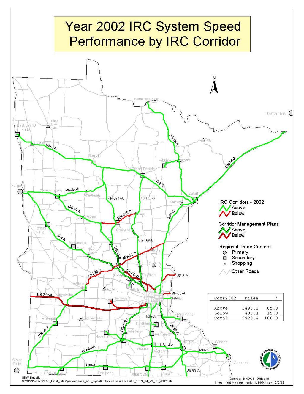
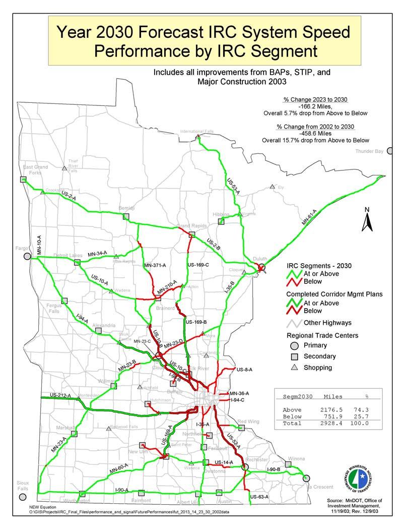
8 Priority Corridors Results! IRC is ~ 2,926 miles long! ~ 56% of existing principal arterial system! 1/3 of system 1,007 miles, is HPI! 2/3 of system 1, 919 miles, is MPI! HPI and MPI account for < 2% of all roadway miles in MN! But carry > 30% of vehicle miles traveled August, 2004 ESRI
9 Performance Measures! Speed (surrogate for travel time) methodology: " Posted speed limits " Number of signals " Congestion! This established an overall speed or travel time for the corridor August, 2004 ESRI
10 Performance Targets! Establishing target levels " 60 mph for HPI " 55 mph for MPI " 50 mph for high-priority Regional corridors August, 2004 ESRI
11 Evaluating Corridor Performance! Methodology: 1. Posted speeds 2. Base Travel Time 3. Capacity Risk 4. Traffic Control Devices August, 2004 ESRI
12 Evaluating Corridor Performance! Methodology: (con t) 5. Capacity 6. Adjusted Travel Time 7. Current and future performance compliance August, 2004 ESRI
13 Adjustments 1. Base speeds were increased by 3 mph 2. Congestion Penalty 3. Signal Penalties August, 2004 ESRI
14 Performance Target Matrix Performance Targets Interregional Corridor Priority Level Performance Category High-Priority Medium-Priority At or Above Below >= 60 mph >= 55 mph < 60 mph < 55 mph
15 Congestion Thresholds CONGESTION THRESHOLDS Volume Threshold (AADT per Lane) Congestion Index Risk Added Delay Penalty Level Freeway <= 15,000 Low 0% 15,000-20,000 Moderate (AADT/Lane - 15,000) / 167 > 20,000 Severe 50% Rural Expressway <= 8,000 Low 0% 8,000-11,000 Moderate (AADT/Lane - 8,000) / 100 > 11,000 Severe 50% Urban Expressway <= 5,000 Low 0% 5,000-7,000 Moderate (AADT/Lane - 5,000) / 67 > 7,000 Severe 50% Two-Lane <= 4,500 Low 0% 4,500-7,500 Moderate (AADT/Lane - 4,500) / 100 > 7,500 Severe 50%
16 Signal Time Penalty SIGNAL TIME PENALTY Location Low Congestion Moderate Congestion Severe Congestion 28 seconds 43 seconds 50 seconds Greater Minnesota 11 seconds 17 seconds 20 seconds Metro Area 15 seconds 24 seconds 29 seconds 37 seconds 61 seconds 73 seconds Blue = New Equation White = Original Equation
17 Spreadsheet Examples
18 Weighted Posted Speed Adjusted Speed Base Travel Time Signal Delay Stop Sign Delay Weighted AADT Weighted Lanes Facility Type = Posted speed * (segment length / total segment length) = Weighted Posted speed + 3 mph = (Length / Adjusted speed) * 3600 (to get seconds) = see previous slide = # stop signs * 14 seconds (originally used 37 secs) = AADT * (segment length / total segment length) = Weighted AADT / # Weighted Lanes = Vlookup to speed_lanes03 spreadsheet Congestion Index Risk = Formula based on Congestion Thresholds see slide Added Delay Penalty = Formula based on Congestion Thresholds see slide Added Congestion Delay = Base Travel Time * Added Delay Penalty TOTAL Travel Time = Base Time + Signal Delay + Stop Sign Delay + Added Congestion Delay Final Speed = (Segment Length / Total Travel Time) * 3600 PERFORMANCE = See Performance Target Slide
19 Spreadsheets / Maps! Examples August, 2004 ESRI

20
21
22 What s Next! Updated spreadsheet to better fit all of the What If.. scenarios (e.g., future performance analyses)! Automate August, 2004 ESRI
23 Closing! IRCs and planning process widely accepted by local communities! Corridor importance is recognized! Provides an opportunity for communities and local agencies to work together August, 2004 ESRI
24 Data Sources! Interregional Corridors A Guide for Plan Development and Corridor Management, MnDOT, September, Interregional Corridors Prioritizing and Managing Critical Connections Between Minnesota s Economic Centers, by Linda Zemotel and David Montebello " Transportation Research Record 1817; Paper No August, 2004 ESRI
25 Contact! Richard Bautch " IRC Coordinator " Ed Idzorek " Transportation Program Financial Planning Director " Paul Jung " Office of Investment Management " August, 2004 ESRI
1.0 INTRODUCTION 1.1 TH 14 WEST STUDY AREA Project Description Functional Classification Purpose of the Project
 1.0 INTRODUCTION 1.1 TH 14 WEST STUDY AREA 1.1.1 Project Description The Trunk Highway (TH) 14 West Corridor is a two-lane roadway approximately 22 miles in length. Located in Nicollet County, the corridor
Congestion Management Safety Plan. Michael Corbett State Program Administrator September 2017
 Congestion Management Safety Plan Michael Corbett State Program Administrator September 2017 Agenda Topic 1 What is the Congestion Management Safety Plan (CMSP)? 2 Relevance to Congestion Investments 3
MODEL ACCESS MANAGEMENT PLAN MINNESOTA TRUNK HIGHWAY 7 COMPREHENSIVE PLAN AMENDMENT (HUTCHINSON SEGMENT)
") MODEL ACCESS MANAGEMENT PLAN MINNESOTA TRUNK HIGHWAY 7 (HUTCHINSON SEGMENT) COMPREHENSIVE PLAN AMENDMENT INTRODUCTION. The purpose of this plan is to provide consistent access management in the Trunk
MODEL ACCESS MANAGEMENT PLAN MINNESOTA TRUNK HIGHWAY 7 (HUTCHINSON SEGMENT) COMPREHENSIVE PLAN AMENDMENT INTRODUCTION. The purpose of this plan is to provide consistent access management in the Trunk
PREPARED FOR: PLATTEVIEW ROAD CORRIDOR STUDY EXECUTIVE SUMMARY
 PREPARED FOR: PLATTEVIEW ROAD CORRIDOR STUDY EXECUTIVE SUMMARY SEPTEMBER 2016 Introduction The Platteview Road Corridor Study was led by the Metropolitan Area Planning Agency (MAPA) with assistance from
NORTH-SOUTH CORRIDOR STUDY EXECUTIVE SUMMARY. Executive Summary
 Executive Summary Background As congestion continues to affect mobility in the region, the Ozarks Transportation Organization (OTO) is particularly concerned with traffic movement. The North-South Corridor
495/MetroWest Development Compact Plan Citizen Planner Training Collaborative Conference. March 17, 2012
 495/MetroWest Development Compact Plan Citizen Planner Training Collaborative Conference March 17, 2012 Project Process Local and Regional Priority Areas Growth Scenarios Transportation Investment Categories
Existing Transportation System 5-1
 5-1 The Jackson County transportation system is served by several modes of transportation including streets and highways, multi-modal, non-motorized, rail, and aviation. While the focus of the transportation
HIGHWAY DEPARTMENT: Planning and Programming Division: An Inventory of Its Transportation Planning Studies
 MINNESOTA HISTORICAL SOCIETY Minnesota State Archives HIGHWAY DEPARTMENT: Planning and Programming Division: An Inventory of Its Transportation Planning Studies OVERVIEW OF THE RECORDS Agency: Minnesota.
Metropolitan Council Transportation Committee
 Rochester-Twin Cities Passenger Rail Corridor Investment Plan Metropolitan Council Transportation Committee June 9, 2014 Project Sponsors Minnesota Department of Transportation Passenger Rail Office Dan
Regional Mobility & the US 380 Bypass Concept. Informational Meeting February 9, 2017
 Regional Mobility & the US 380 Bypass Concept Informational Meeting February 9, 2017 Purpose and Agenda Purpose: Regional Mobility Issues, Priorities, and Pressures US 380 as a Limited Access Facility
Design Speed / Target Speed Primer. Jim Rosenow AASHTO Technical Committee on Geometric Design June 12, 2018
 Design Speed / Target Speed Primer Jim Rosenow AASHTO Technical Committee on Geometric Design June 12, 2018 Predecessor research NCHRP Project 15-25 NCHRP Project 15-47 2 Predecessor research NCHRP Project
Hastings Area Roadway System Study. February 2009
 Hastings Area Roadway System Study February 2009 TABLE OF CONTENTS EXECUTIVE SUMMARY... iii I. INTRODUCTION & BACKGROUND... 1 A. STUDY GOAL & STUDY AREA... 1 B. NEED FOR STUDY... 1 C. AGENCY COORDINATION
Site Formation Excavation - 6' depth square yard $8.00 $0.00 Grading square yard $1.50 $0.00 Hauling off-site - 6' depth square yard $10.00 $0.
 SURFACE SAND FILTER COST ESTIMATE WORKSHEET 2005 Prices Project Title Owner Location Project Number Date Description Units Quantity Unit Cost Total Estimated Price Site Preparation Tree removal - up to
ARGENTA TRAIL (CSAH 28/63) REALIGNMENT SOUTH PROJECT (CP 63-25)
 REALIGNMENT SOUTH PROJECT (CP 63-25)") ARGENTA TRAIL (CSAH 28/63) REALIGNMENT SOUTH PROJECT (CP 63-25) Preliminary Design Report February 2015 Prepared For: City of Inver Grove Heights Dakota County Prepared By: Kimley-Horn and Associates,
ARGENTA TRAIL (CSAH 28/63) REALIGNMENT SOUTH PROJECT (CP 63-25) Preliminary Design Report February 2015 Prepared For: City of Inver Grove Heights Dakota County Prepared By: Kimley-Horn and Associates,
I-75 Overpass Study Summary
 I-75 Overpass Study Summary Sarasota County Transportation Planning evaluated various I-75 Overpass alternatives between University Parkway and Fruitville Road. Additionally, a consultant, Hanson Professional
Communities Plan. Parkland-Spanaway-Midland. LUAC Review of Draft Policies
 Parkland-Spanaway-Midland Communities Plan LUAC Review of Draft Policies Presented by: Tiffany O Dell, Senior Planner Planning & Public Works Tiffany.Odell@co.pierce.wa.us 253-798-6859 November 1, 2017
CITY COUNCIL AGENDA REPORT
 CITY COUNCIL AGENDA REPORT Subject: COUNCIL MOTION LRT ALIGNMENT REMOVAL FROM THE TRANSPORTATION MASTER PLAN On February 10, 2016 Councillor Hughes provided notice in accordance with Section 23 of Procedure
APPENDIX P MASTER STREETS AND HIGHWAYS PLAN ACCESS2040 APPENDIX P (MASTER STREETS AND HIGHWAYS PLAN)
") APPENDIX P MASTER STREETS AND HIGHWAYS PLAN ACCESS2040 APPENDIX P (MASTER STREETS AND HIGHWAYS PLAN) Introduction This element of the Access2040 Regional Transportation Plan provides the Southern Nevada
APPENDIX P MASTER STREETS AND HIGHWAYS PLAN ACCESS2040 APPENDIX P (MASTER STREETS AND HIGHWAYS PLAN) Introduction This element of the Access2040 Regional Transportation Plan provides the Southern Nevada
I. INTRODUCTION. Project Background and Study Area
 I. INTRODUCTION Project Background and Study Area Freedom Parkway is a key east-west corridor connecting I-25 on the west to the Town of Kersey on the east, running approximately one to two miles south
WHAT IS THE PURPOSE OF THE OPEN HOUSE?
 WHAT IS THE PURPOSE OF THE OPEN HOUSE? OPEN HOUSE PURPOSE The purpose of the open house is to provide an update on the study process and introduce the preliminary concept alternatives. The open house provides
City of Phoenix Street Transportation Department East Sonoran Parkway Alignment (ESPA) Committee Committee Recommendation April 2006
 Committee Committee Recommendation April 2006") SONORAN PARKWAY BACKGROUND City of Phoenix Street Transportation Department Important east-west alignment for congested northeast Phoenix Alignment on Street Classification map since 1987 Originally shown
SONORAN PARKWAY BACKGROUND City of Phoenix Street Transportation Department Important east-west alignment for congested northeast Phoenix Alignment on Street Classification map since 1987 Originally shown
Street Flooding Mitigation Plan KYOVA Interstate Planning Commission. Presented to AMPO National Conference October 18, 2017
 Street Flooding Mitigation Plan KYOVA Interstate Planning Commission Presented to AMPO National Conference October 18, 2017 Saleem Salameh, Ph.D., P.E., M.ASCE Chet Parsons, AICP CTP Agenda: Background
TRANSPORTATION ELEMENT GOALS, OBJECTIVES, AND POLICIES
 TRANSPORTATION ELEMENT GOALS, OBJECTIVES, AND POLICIES GOAL 2 The City shall provide a safe, convenient, effective, and energy efficient multimodal transportation system which is coordinated with the Future
Creating a Walkability Surface for Maricopa County
 Creating a Walkability Surface for Maricopa County Parul Singh and Madison Davis ASU MAS-GIS students Co-Authors: Marc Adams, Jane Hurley, Lu Hao Funding Source #: R01CA198915 Overview Background on Walkability
12/9/2013. HOLLYWOOD/PINES CORRIDOR PROJECT AMPO 2013 Annual Conference October 24, Our Perspective. Broward.
 HOLLYWOOD/PINES CORRIDOR PROJECT AMPO 2013 Annual Conference October 24, 2013 Our Perspective Broward Fort Lauderdale 1 Broward Metropolitan Planning Organization Fort Lauderdale Fort Lauderdale Skyline
DRAFT Subject to Modifications
 TREASURE COAST REGIONAL PLANNING COUNCIL M E M O R A N D U M To: Council Members AGENDA ITEM 8 From: Date: Subject: Staff May 19, 2017 Council Meeting Florida Department of Transportation Complete Streets
MORRISVILLE TRANSPORTATION PLAN TOWN COUNCIL PRESENTATION AUGUST 22, 2017
 TOWN COUNCIL PRESENTATION AUGUST 22, 2017 SCENARIO PLANNING CORRIDORS Town Hall Drive Baseline + 2 McCrimmon Parkway Baseline + 2 NC 54 Baseline + 2 7 subregion model runs determining carrying capacity
C h a p t e r 4 - L a n d U s e, T r a n s p o r t a t i o n N e t w o r k & S o c i o e c o n o m i c C h a r a c t e r i s t i c s
 C h a p t e r 4 - L a n d U s e, T r a n s p o r t a t i o n N e t w o r k & S o c i o e c o n o m i c C h a r a c t e r i s t i c s In order to properly develop a community-based transportation plan for
Chapter 3: Land Use and Local Planning
 3.1 Chapter 3: Land Use and Local Planning 2040 3.2 Chapter 3: Land Use and Local Planning CONTENTS Introduction 3.3 Coordinating Thrive MSP 2040 and Transportation Policy Plan 3.6 Coordination of Regional
2.0 PURPOSE AND NEED. 2.1 Purpose. 2.2 Need Traffic Congestion in and around Downtown Derry
 2.0 PURPOSE AND NEED Taking into consideration agency and public input, the purpose and need for the Project was identified early in Project planning. As noted in Appendix A, for purposes of meeting the
City of Norfolk Coastal Flood Mitigation Program. March 13, 2013
 City of Norfolk Coastal Flood Mitigation Program March 13, 2013 Topics Brief overview of Norfolk s Coastal Flood Program Data-driven analysis and decision making City-wide vulnerability, project concepts,
Advance Warning Flasher System at High Speed
 Evaluation of Integrated t Platoon-Priority Pi it and Advance Warning Flasher System at High Speed Intersections Dr. Henry Liu Sundeep Bhimireddy Department of Civil Engineering University of Minnesota,
I-90 Mississippi River Bridge & Interchange Project
 I-90 Mississippi River Bridge & Interchange Project Presentation Outline I. Background: Context & Need for Project II. Preferred Alternative Overview III. Project Development IV. Project Management Tools
TH 336/CSAH 11 CORRIDOR MANAGEMENT PLAN
 TH 336/CSAH 11 CORRIDOR MANAGEMENT PLAN DRAFT REPORT Prepared For: Mn/DOT, FMCOG, Clay County, and Local Government Partners Prepared By: SRF Consulting Group, Inc. November 2003 0024613 TABLE OF CONTENTS
IMPLEMENTING SOMERSET COUNTY S INVESTMENT FRAMEWORK
 IMPLEMENTING SOMERSET COUNTY S INVESTMENT FRAMEWORK SMART CONSERVATION THROUGH SMART GROWTH NJ LAND CONSERVATION RALLY March 22, 2014 Laurette Kratina, PP, AICP, Supervising Planner Somerset County Planning
Land Use and Local Planning
 Chapter 3 Land Use and Local Planning Introduction Transportation and land use play off each other. Transportation infrastructure gives value to land and influences its use. Land use, in turn, creates
2. AGENCY COORDINATION AND PUBLIC INVOLVMENT
 2. AGENCY COORDINATION AND PUBLIC INVOLVMENT This chapter discusses the process carried out for conducting agency coordination and public involvement activities. TECHNICAL ADVISORY COMMITTEE A Technical
Lake Oswego to Portland Transit Project. Lessons Learned. John Cullerton Senior Project Manager, URS 2012 APTA/TRB Light Rail Conference
 Lake Oswego to Portland Transit Project Lessons Learned John Cullerton Senior Project Manager, URS 2012 APTA/TRB Light Rail Conference Overview Project Location and Context Corridor History and Project
Iowa 100 Extension Project Visualizations for Design and Public Involvement ASCE Transportation Conference November 6, 2013 Ames, Iowa
 Iowa 100 Extension Project Visualizations for Design and Public Involvement 2013 ASCE Transportation Conference November 6, 2013 Ames, Iowa Agenda Project Corridor Constraints Key Features Project History
5.0 IMPLEMENTATION STRATEGIES
 5.0 IMPLEMENTATION STRATEGIES 5.1 Recommended Alternative This chapter discusses the anticipated steps needed to move each project from recommendation to construction. Since full funding for these alternatives
DRAFT SECTION 4(F) EVALUATION LIFT BRIDGE
 EVALUATION LIFT BRIDGE") DRAFT SECTION 4(F) EVALUATION I. DESCRIPTION OF SECTION 4(F) RESOURCE The Section 4(f) resource affected by the proposed action is the Lift Bridge, a property listed on the National Register of Historic
DRAFT SECTION 4(F) EVALUATION I. DESCRIPTION OF SECTION 4(F) RESOURCE The Section 4(f) resource affected by the proposed action is the Lift Bridge, a property listed on the National Register of Historic
Appendix A. Summary of Key Findings: US Hwy Corridor Study. Retail-Commercial Development Plan Page A-1
 Retail-Commercial Development Plan 2020 Appendix A Summary of Key Findings: US 24-40 Hwy Corridor Study Introduction The US 24-40 Corridor Study was initiated by state, regional, county and city officials
Mississippi Skyway Preliminary Engineering Report
 EXECUTIVE SUMMARY Mississippi Skyway Preliminary Engineering Report CITY OF RAMSEY, MINNESOTA DECEMBER 2014 City of RAMSEY EXECUTIVE SUMMARY Project Need and Intent The Mississippi Skyway pedestrian bridge
2018 Priority Regional Transportation Projects. Integrated Regional Transportation Master Plan
 2018 Priority Regional Transportation Projects June 14, 2018 Table of Contents 1.0 INTRODUCTION 3 1.1 BACKGROUND 3 1.2 OBJECTIVES 3 2.0 METHODOLOGY 4 2.1 OVERVIEW OF EVALUATION PROCESS 4 2.2 PROJECT LIST
Transportation Systems and Utility Infrastructure
 77 Audience Local and regional units of government, Landowners and developers, Community and citizen organizations, and Transportation/utility planners and engineers. Overview Transportation systems and
MDX SR 836/DOLPHIN EXPRESSWAY SOUTHWEST EXTENSION
 MDX SR 836/DOLPHIN EXPRESSWAY SOUTHWEST EXTENSION Project Development and Environment (PD&E) STUDY Miami-Dade County, Florida Preliminary Executive Summary Alternative Corridor Evaluation (ACE) Report
Chapter 3 Land Use and Local Planning
 Chapter 3 Land Use and Local Planning Introduction Transportation and land use play off each other. Transportation infrastructure gives value to land and influences its use. Land use, in turn, creates
4.11 TRAFFIC Existing Conditions Existing Project Site. Existing Street System
 4.11 TRAFFIC This traffic and circulation section is based on a Traffic Impact Study conducted by Linscott Law & Greenspan Engineers, which is provided in full in Appendix F. This traffic analysis has
IDENTIFYING, EVALUATING, AND PRESERVING MINNESOTA'S HISTORIC ROADSIDE FACILITIES
 IDENTIFYING, EVALUATING, AND PRESERVING MINNESOTA'S HISTORIC ROADSIDE FACILITIES Overview Minnesota built many wayside rest areas during 1930s & '40s (New Deal-WPA, CCC) Many are now threatened Limited
Whitehurst Freeway Deconstruction Feasibility Study
 Whitehurst Freeway Deconstruction Feasibility Study Draft Existing Conditions Report Prepared By: For: District Department of Transportation District of Columbia October 2005 TABLE OF CONTENTS 1. INTRODUCTION...1-1
PROJECT BACKGROUND. Preliminary Design Scope and Tasks
 PROJECT BACKGROUND Preliminary Design Scope and Tasks The purpose of this Study is the development of preliminary designs for intersection improvements for Trunk Highway (TH) 36 at the intersections of
SUNBRIDGE PARKWAY PRELIMINARY DESIGN STUDY. Board of County Commissioners Public Hearing
 SUNBRIDGE PARKWAY PRELIMINARY DESIGN STUDY Board of County Commissioners Public Hearing March 20, 2018 Presentation Overview Study Overview Existing Conditions Project Development Plan Public Involvement
HAZARD MITIGATION GOALS AND OBJECTIVES
 SEWRPC Community Assistance Planning Report No. 282, 2nd Edition CITY OF MILWAUKEE ALL HAZARDS MITIGATION PLAN UPDATE Chapter IV HAZARD MITIGATION GOALS AND OBJECTIVES [NOTE: Throughout this plan update
Figure 1. Park Ave. Portsmouth
 Aquidneck Island Resilience Strategy Issue Paper 2 Issue: TRANSPORTATION Description of Concern: Aquidneck Island encompasses a 38 square mile area, including three municipalities, all supported by an
Onondaga County Sustainable Streets Project. Onondaga County Planning Federation June 7, Onondaga County Sustainable Streets Project 1
 Onondaga County Sustainable Streets Project Onondaga County Planning Federation June 7, 2012 Onondaga County Sustainable Streets Project 1 Sustainable Streets 1. Introduction to the SMTC 2. Sustainable
Infrastructure Engineering Planning Construction Suite 300 Minneapolis, MN Tel: Fax:
 Infrastructure Engineering Planning Construction 701 Xenia Avenue outh uite 300 Minneapolis, MN 55416 Tel: 763-541-4800 Fax: 763-541-1700 Memorandum To: Minnehaha Creek Watershed District Board From: Tony
Appendix B: C Line Station Plan Agency/ Organization Comments
 Appendix B: C Line Station Plan Agency/ Organization Comments C Line Public Engagement Plan Appendix B January 5, 2016 Scott Janowiak Metro Transit 560 Sixth Avenue North Minneapolis, MN 55411 Dear Mr.
S C O P E O F W O R K A P R I L
 white flint 2 sector plan S C O P E O F W O R K A P R I L 2 0 1 2 MONTGOMERY COUNTY PLANNING DEPARTMENT M-NCPPC MontgomeryPlanning.org 1 white flint 2 sector plan Scope of Work abstract This scope of work
Issues Requiring Future Study
 Issues Requiring Future Study Transportation planning is an ongoing process that tends to identify new issues as it finds solutions for others. Some issues are so complex that a solution to one problem
This chapter describes the purpose of the Plan, introduces how the Plan is organized and provides contextual background for the Plan.
 Chapter 1: INTRODUCTION Purpose of a Comprehensive Plan The 2040 Comprehensive Plan establishes Medina s vision as a community and sets goals and objectives which guide future decisions and policies. The
State Highway 121 Southwest Parkway. Fort Worth s Transportation Success Story in Design and Cooperation
 State Highway 121 Southwest Parkway Fort Worth s Transportation Success Story in Design and Cooperation Greater Fort Worth Association of Realtors October 24, 2007 Presented by: Dan Lamers, P.E. North
District of Muskoka Transportation Study
 District of Muskoka Transportation Study January 18, 2017 EPW Committee Presentation Study Purpose 2 1 Road Rationalization Review 2 Road Classification Review 3 Road Standards Review 4 Transportation
Joint Meeting City Council and the Plan Commission. September 1st, 2015
 Joint Meeting City Council and the Plan Commission September 1st, 2015 1 The City Plan Commission shall recommend a City Plan for the physical development of the City Article IX Section 2 of the City of
FDOT D4 Complete Streets
 FDOT D4 Complete Streets Context Sensitive Solutions Directs that complete street solutions will complement the context of the community. Collaborative approach to decision making, project development,
List of Priority Projects
 List of Priority Projects Fiscal Years 2019-20 to 2023-24 June 25, 2018 Amended December 17, 2018 Metropolitan Transportation Planning Organization for the Gainesville Urbanized Area List of Priority
REVIEW AND EVALUATION OF REGIONAL LAND USE
 REVIEW AND EVALUATION OF REGIONAL LAND USE AND TRANSPORTATION SCENARIOS #220831 Environmental Justice Task Force October 7, 2014 VISION 2050 Process Development of Guiding Vision for Land Use and Transportation
Longmeadow Parkway Fox River Bridge Corridor. August 6, 2015
 Longmeadow Parkway Fox River Bridge Corridor August 6, 2015 Longmeadow Parkway Bridge Corridor 5.6 miles from Huntley Road to IL 62 Unique municipal/county/state/federal partnership Links Randall Road
Figure 5. Previously Identified Viable Corridors
 OVERVIEW The Central Florida Expressway Authority (CFX) is evaluating the potential to expand SR 408 from its current eastern terminus along SR 50 to SR 520 in northeastern Orange County, Fl. This new
Economic Development & Housing Council Committee Comprehensive Plan Update September 20, 2005
 1 Economic Development & Housing Council Committee Comprehensive Plan Update September 20, 2005 Purpose To update the Committee on the ForwardDallas! Plan, including: Status Anticipated Products Public
master plan of highways bus rapid transit amendment
 Scope of Work master plan of highways bus rapid transit amendment September 2011 Montgomery County Planning Department M-NCPPC MontgomeryPlanning.org 1 Scope of Work master plan of highways bus rapid transit
Harlem Avenue Corridor Plan: Corridor Planning Across Municipal Boundaries
 Harlem Avenue Corridor Plan: Corridor Planning Across Municipal Boundaries Heather Tabbert, Manager, Local Planning and Programs Division Regional Transportation Authority (RTA) Jen McNeil Dhadwal, Principal
Section 1. Executive Summary
 Executive Summary (This page left blank intentionally) Executive Summary Background Economic growth in southern Leavenworth County over the past decade has been strong. As both the number of business and
West Broadway Transit Study Initial Screening of Alternatives Memo
 West Broadway Transit Study Initial Screening of Alternatives Memo 5/22/2015 Prepared by the SRF Consulting Group Team for Table of Contents Purpose... 1 Methodology... 1 Screening... 5 Screening Criteria...
VISUALIZATION TOOLS FOR COMMUNICATION & DECISION MAKING REAL MINNESOTA EXAMPLES
 REAL MINNESOTA EXAMPLES 23rd Annual CTS Transportation Research Conference Leif Garnass, P.E., PTOE Senior Engineer lgarnass@srfconsulting.com Sean Jergens, ASLA, LEED AP Senior Landscape Architect sjergens@srfconsulting.com
Gratigny Parkway East Extension Project Development & Environment (PD&E) Study
 Study") Gratigny Parkway East Extension Project Development & Environment (PD&E) Study Session 4: Presentation of Charrette Results December 8, 2010 MDX Work Program #: 92407 ETDM#: 11500 Project Location & Description
Gratigny Parkway East Extension Project Development & Environment (PD&E) Study Session 4: Presentation of Charrette Results December 8, 2010 MDX Work Program #: 92407 ETDM#: 11500 Project Location & Description
I-710 Corridor Advisory Committee. Gary Hamrick, Iteris
 St t i Transportation Strategic T t ti Plan: Pl Traffic T ffi Modeling M d li U Update d t Presented to: Presented by: I-710 Corridor Advisory Committee Gill V V. Hicks Hicks, Cambridge Systematics Systematics,
Innovative Worldwide VE Case Studies & How Cultural Values Impact Creativity
 Innovative Worldwide VE Case Studies & How Cultural Values Impact Creativity August 30 - September 2, 2009 2009 AASHTO VE Conference San Diego, CA George Hunter, PE, PMP, CVS Value Management Strategies
Implementation Guide Comprehensive Plan City of Allen
 Implementation Guide 2030 Comprehensive Plan City of Allen DRAFT 2015 Implementation Guide Allen 2030 Comprehensive Plan INTRODUCTION The Comprehensive Plan serves as a guide for the growth and development
Corridor Vision. 1Pursue Minnehaha-Hiawatha Community Works Project. Mission of Hennepin County Community Works Program
 1Pursue Minnehaha-Hiawatha Community Works Project Minnehaha-Hiawatha Community Works is a project within the Hennepin Community Works (HCW) program. The mission of the HCW program is to enhance how the
Albert Lea. Redevelopment Plan. 701 Xenia Avenue South, Suite 300 Minneapolis, MN Tel: (763) Fax: (763) wsbeng.
 Fax: (763) wsbeng.") Albert Lea Redevelopment Plan 701 Xenia Avenue South, Suite 300 Minneapolis, MN 55416 Tel: (763) 541-4800 Fax: (763) 541-1700 wsbeng.com Albert Lea Redevelopment Plan Table of Contents Composite Districts...
Albert Lea Redevelopment Plan 701 Xenia Avenue South, Suite 300 Minneapolis, MN 55416 Tel: (763) 541-4800 Fax: (763) 541-1700 wsbeng.com Albert Lea Redevelopment Plan Table of Contents Composite Districts...
Secrest Short Cut and Monroe Expressway Small Area Plan AUGUST 29, 2018
 Secrest Short Cut and Monroe Expressway Small Area Plan AUGUST 29, 2018 Background and Process Monroe Expressway will be open by the end of 2018 Union County and Indian Trail identified a need to revisit
Definitions. Average Daily Traffic Demand (ADT): The actual number or projected number of cars that pass a point in a 24-hour period.
: The actual number or projected number of cars that pass a point in a 24-hour period.") Definitions Access Management: A combination of physical techniques and transportation policies used to control the flow of traffic between roads and the surrounding lands. Alternative City Form Scenarios:
Definitions Access Management: A combination of physical techniques and transportation policies used to control the flow of traffic between roads and the surrounding lands. Alternative City Form Scenarios:
Transportation Impact Study Technical Working Group (TISTWG) July 1, 2015 Meeting #10 1:30-3:30 PM Agenda
 July 1, 2015 Meeting #10 1:30-3:30 PM Agenda") Transportation Impact Study Technical Working Group (TISTWG) July 1, 2015 Meeting #10 1:30-3:30 PM Agenda 1) Final review and comment on Pro-Rata Share Approach 2) Summary and status of LATR Concepts moving
Transportation Impact Study Technical Working Group (TISTWG) July 1, 2015 Meeting #10 1:30-3:30 PM Agenda 1) Final review and comment on Pro-Rata Share Approach 2) Summary and status of LATR Concepts moving
Remi Mendoza City Planning Academy March 13, 2017
 Remi Mendoza City Planning Academy March 13, 2017 1 What is the General Plan? The 2030 General Plan 5-Year Update (2035 General Plan) Questions and Answers 2 Guidebook for development and growth Required
LAND USE MODEL UPDATE. Planning and Land Use Advisory Committee Meeting #2 September 4, 2014
 1 LAND USE MODEL UPDATE Planning and Land Use Advisory Committee Meeting #2 September 4, 2014 2 Presentation Outline Introduction and Recap Model Process Study Design Place Types Suitability Factors 3
7.0 SOCIAL, ECONOMIC, AND ENVIRONMENTAL ISSUES
 7.0 SOCIAL, ECONOMIC, AND ENVIRONMENTAL ISSUES The following list of social, economic, and environmental issues have been identified based on a preliminary inventory of resources in the project area, an
HARBOR BRIDGE. Randall C. Grones, PE - SPD. US 181 Harbor Bridge October
 HARBOR BRIDGE Randall C. Grones, PE - SPD US 181 Harbor Bridge October October 13, 13, 2015 2015 Project Scope Develop, design, construct and maintain a total project length of 6.44 miles. Base scope New
Introduction. Public Information Package. Project website. Overview. Class Environmental Assessment Process
 1 Introduction Public Information Package Baseline Road Extension between Lambs Road and Bennett Road, Bowmanville Schedule B Municipal Class Environmental Assessment November 6, 2017 Overview The purpose
Environmental Assessment Page Purpose and Need
 Environmental Assessment Page 1-1 1. Purpose and Need This chapter describes the location and setting of the Gateway Corridor project, the needs driving the study of the project, the purpose of the project,
Create Policy Options Draft Plan Plan Approval. Public Consultation Events. Phase 2
 Background Grandview-Woodland Community Plan In the spring of 2012, the City of Vancouver embarked on a comprehensive community planning program in the Grandview-Woodland neighbourhood. The process has
Courtice Main Street Study Community Vision Workshop PLANNING SERVICES DEPARTMENT
 Courtice Main Street Study Community Vision Workshop PLANNING SERVICES DEPARTMENT July 22, 2009 Tonight s Meeting 7:00 pm Introduction David Crome, Director of Planning 7:05 Presentation Stasia Bogdan,
Overview of Southwestern Pennsylvania Commission s (SPC) 2040 Long Range Transportation Plan (LRTP)
 2040 Long Range Transportation Plan (LRTP)") Overview of Southwestern Pennsylvania Commission s (SPC) 2040 Long Range Transportation Plan (LRTP) Presented to Pennsylvania Agency Coordination Meeting May 27, 2015 Doug Smith & Ryan Gordon 1 Southwestern
Overview of Southwestern Pennsylvania Commission s (SPC) 2040 Long Range Transportation Plan (LRTP) Presented to Pennsylvania Agency Coordination Meeting May 27, 2015 Doug Smith & Ryan Gordon 1 Southwestern
AASHTO SUBCOMMITTEE ON DESIGN. June 15, 2006 MARK ROBINSON, P.E. DISTRICT 5 INTERSTATE PROGRAM MANAGER FLORIDA DEPARTMENT OF TRANSPORTATION
 AASHTO SUBCOMMITTEE ON DESIGN June 15, 2006 MARK ROBINSON, P.E. DISTRICT 5 INTERSTATE PROGRAM MANAGER FLORIDA DEPARTMENT OF TRANSPORTATION CENTRAL FLORIDA INTERSTATE 4 FACTS Trucks and Others 12% Tourist
OFFICIAL CONTROLS IMPLEMENTATION LEGAL REQUIREMENTS
 IMPLEMENTATION The objective of the Implementation component of the Comprehensive Plan is to identify the changes that need to be made to the official controls in order to be consistent with the Comprehensive
Route 1 Corridor Study
 Route 1 Corridor Study Westbrook, Connecticut A Vision for the Connecticut Shoreline Public Informational Meeting July 28, 2015 Lower Connecticut River Valley Council of Governments Fitzgerald & Halliday,
WURZBACH PARKWAY WURZBACH PARKWAY
 WURZBACH PARKWAY WURZBACH PARKWAY From Lockhill-Selma Rd to NW Military Hwy Open NW Military HouseHwy/Lockhill-Selma Open House Barshop Jewish Community Center December Barshop Jewish 14, 2017 Community
Bypass #16 - Bend Parkway (new alignment for US 97) (MP )
 (MP )") Bypass #16 - Bend Parkway (new alignment for US 97) (MP 134.76-141.83) Description: The Parkway is on new alignment for US 97 through Bend. US 97 is a Statewide Highway on the National Highway System that
Bypass #16 - Bend Parkway (new alignment for US 97) (MP 134.76-141.83) Description: The Parkway is on new alignment for US 97 through Bend. US 97 is a Statewide Highway on the National Highway System that
2 STATUTORY PUBLIC MEETING AND INFORMATION REPORT FOR PUBLIC MEETING ON AMENDMENT NO. 62 TO THE YORK REGION OFFICIAL PLAN
 2 STATUTORY PUBLIC MEETING AND INFORMATION REPORT FOR PUBLIC MEETING ON AMENDMENT NO. 62 TO THE YORK REGION OFFICIAL PLAN Pursuant to Section 17(15) of the Planning Act, as amended, the Regional Planning
Industrial Corridor Modernization Little Village
 Industrial Corridor Modernization Little Village Rahm Emanuel, Mayor David Reifman, Commissioner Dept. of Planning and Development Working Group April 26, 2018 dpd@cityofchicago.org cityofchicago.org/dpd
Coordinated Transit Planning in Toronto SmartTrack GO RER Scarborough Relief Line Waterfront Transit
 Coordinated Transit Planning in Toronto SmartTrack GO RER Scarborough Relief Line Waterfront Transit Public Information Centres February 2016 Transportation Planning Section City Planning Division Toronto