Appendix B. Naughton. conservation area appraisal
|
|
|
- Elvin Moody
- 5 years ago
- Views:
Transcription

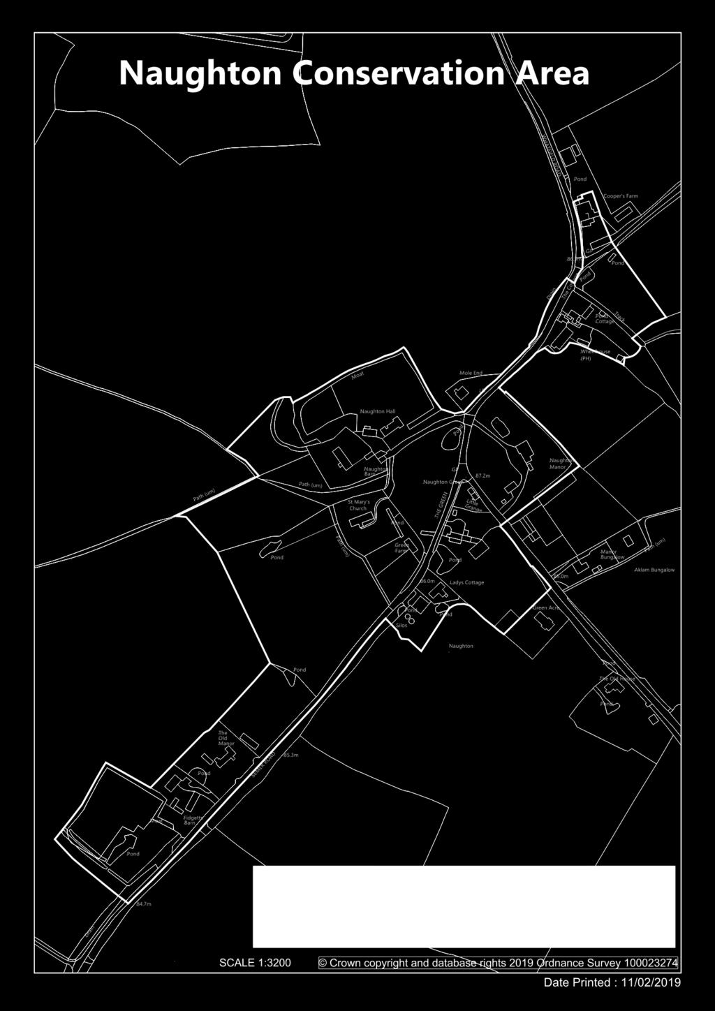
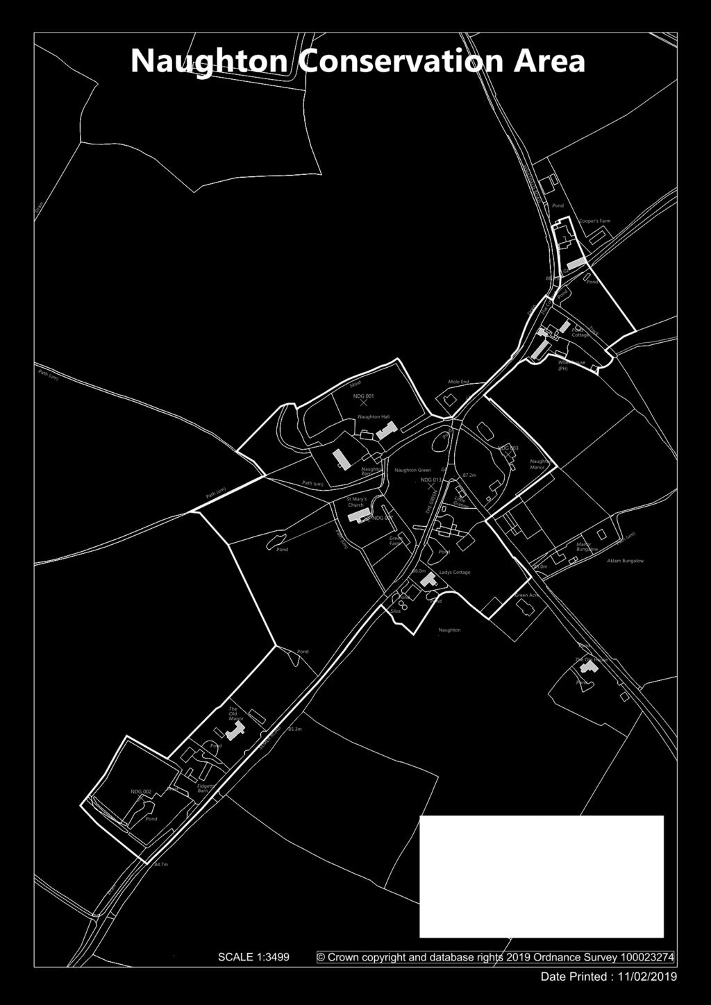
1 Appendix B Naughton conservation area appraisal

2


3 Introduction The conservation area in Naughton was originally designated by Babergh District Council in The Council has a duty to review its conservation area designations from time to time, and this appraisal examines Naughton under a number of different headings as set out in English Heritage s Guidance on Conservation Area Appraisals (2006) and having regard to Historic England s new guidance (2016). This brings the village in line with Babergh s other conservation area appraisals in the same format. As such it is a straightforward appraisal of Naughton s built environment in conservation terms. As a document it is neither prescriptive nor overly descriptive, but more a demonstration of quality of place, sufficient to inform the Planning Officer and others considering changes or assessing proposed works there. The photographs and maps are thus intended to contribute as much as the text itself. As the English Heritage guidelines point out, the appraisal is to be read as a general overview, rather than as a comprehensive listing, and the omission of any particular building, feature or space does not imply that it is of no interest in conservation terms. Text, photographs and map overlays by Patrick Taylor, Conservation Architect, for Babergh District Council 2019.

4 Topographical Framework The village of Naughton is situated in south central Suffolk, about five miles north of the market town of Hadleigh and eight miles east of Lavenham. The settlement sits about two miles north-east of the River Brett, which flows south from here down through Hadleigh and onwards to join the Stour at Higham. Whilst the river valley has cut down through the overlying boulder clay of High Suffolk to reveal locally gravels, crags and pockets of older London Clay, Naughton remains firmly on the edge of that clay plateau. From Needham Market the B1078 road runs through the combined parish of Nedging with Naughton, passing about a quarter mile north of the village on towards Bildeston further east. Off this road at Nedging Tye a minor road heads off south-westwards down the valley side to the village of Nedging. Naughton itself is approximately 80 metres above OD, with the adjoining river valley some 50 metres below. Hadleigh was at one time served by a branch line of the Eastern Union Railway, now closed down, making Needham Market and Stowmarket to the north-east the village s nearest stations.

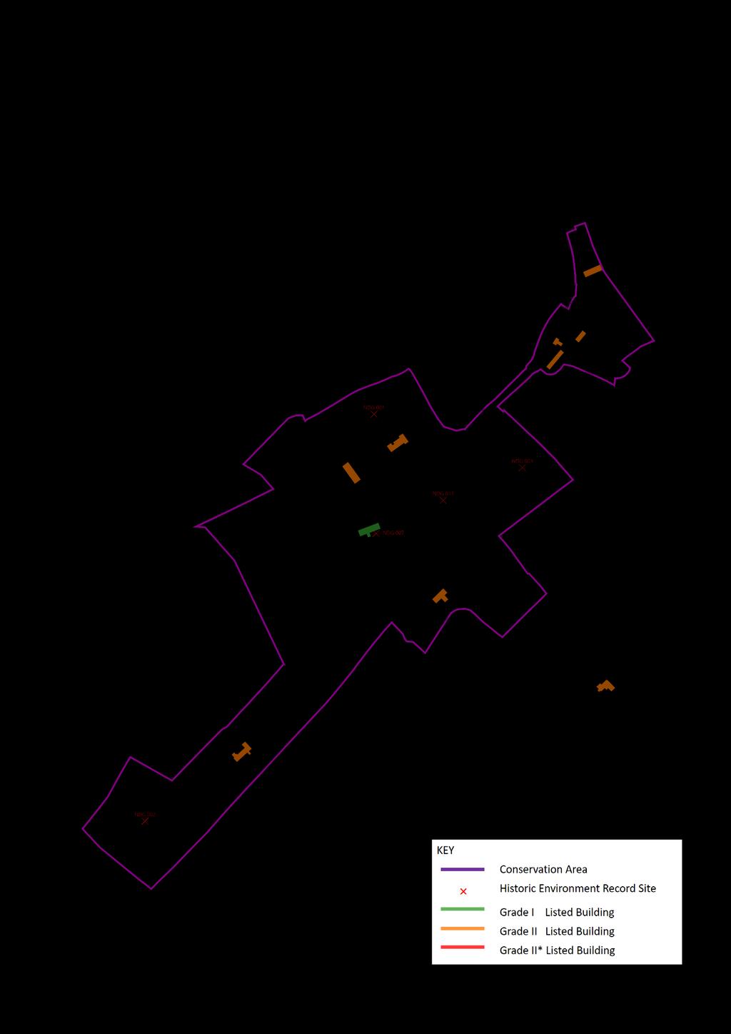
5 Archaeological Significance The Suffolk County Historic Environment Record lists about a dozen sites of archaeological interest in the parish of Nedging with Naughton. The oldest of these is an enclosure cropmark, given as undated, but probably Bronze Age in date. There appear to be no Iron Age, Roman or Saxon finds, but this may be the result of the relatively low level of development in the area. Medieval remains include both the Church of St Mary and another Church site further east, along with a site where 13 th century pottery was discovered. There are also four Medieval moated sites in the area, three framing the conservation area, and two ancient woodlands, probably of similar age. The remaining listing is the Post-Medieval site of a windmill. The adjoining village of Nedging was listed in the Domesday survey of 1086 as belonging to St Etheldreda s prior to 1066, and Roger Bigot at the time. The holding included a meadow of 8 acres and woodland for 6 pigs as well as a church with 7 acres of land.
6


7 Intrinsic Quality of Buildings Naughton has but one grade I listed building, the Church of St Mary of flint with stone dressings, not all visible as unfortunately the nave and chancel have been encased in cement render. It is mostly of 14 th Century date with roofs of plaintile to the nave and slate to the chancel. One other building is of sufficient quality to justify listing at grade II*. This is Brickhouse Farm a little to the east of the conservation area, which has an exposed timber frame with brick nogging and a jetty to the north. It dates from the 15 th or 16 th Century and inside has a straight staircase with quarter log risers, thought to be original. The remaining listed buildings are all grade II and include Naughton Hall near the Church, north of the green. This is 17 th Century, timber-framed and plastered, with a jettied cross wing at the east end. The Old Manor south-west of the green is similarly grade II, 17 th Century and timber-framed, but retains exposed timbers, filled in with red brick nogging.
8


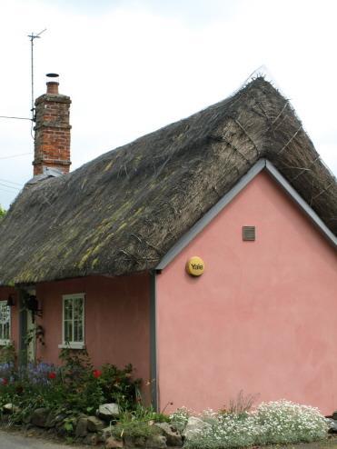
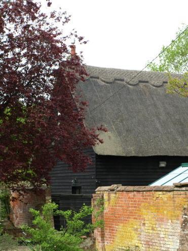
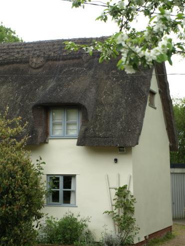
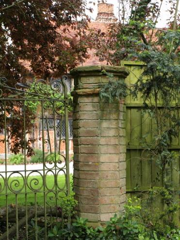
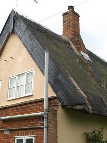
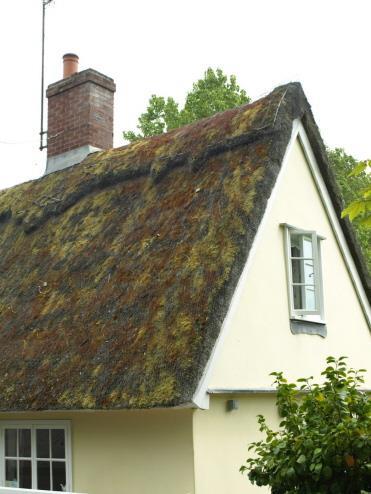
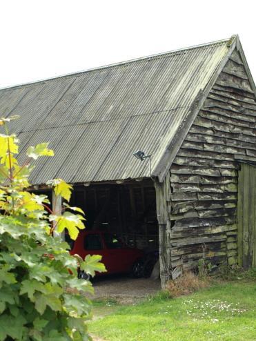
9 Traditional Building Materials Naughton has good examples of most of Suffolk s local building materials that have been used through the ages. Timber-framed construction is fairly ubiquitous, but not always in an immediately obvious way, except in the case of the Old Manor where the framing is visibly infilled with soft Suffolk red brick nogging. The more usual Suffolk vernacular employing a finish of lime render on laths, covering and protecting the timber framing, is mostly used, sometimes with applied patterns in pargetting. Without seeing the timbers steep clay plaintiled roofs are all that remain as visible clues. Soft Suffolk red bricks appear as chimneys on many buildings, and form the walls of those of the 19 th Century, either solid or refronting a timberframed construction. At the Old Manor octagonal gate piers have been built of the harder Suffolk white bricks, probably sourced from Woolpit. Apart from the plaintile roofs, many of the rendered cottages are thatched, and some buildings have had the thatch replaced with slate, probably in the 19 th Century. As with most similar settlements, the barns, outbuildings and rear wings employ slightly lower status materials such as black weather-boarding and clay pantiles for the roofs.


10 Hierarchy of Spaces Naughton is a classic small village with Church, Hall and associated barn clustered around a roughly triangular green. Unusually this triangle is not an expanded road junction. The green lies to the north-west side of the road through the village from Ash Street, Semer to Nedging Tye, at a T- junction where the road from Whatfield joins from the south-east. The Church lies immediately west of the green and the Hall to the north, with the barn tucked into the corner in between. Most of the rest of the development comprising the village lies south-east of the road through. The village thus has a nucleus of development around the green with two outlying areas. The south-western area around the Old Manor, Fidget s Farm and its moated site lies to the south-west and is on the north-west side of the road, whilst the other around the Wheelhouse Inn and Cooper s Farm is to the north-east and, like most of the village, on the south-east side of the road. Most of the development there is on plots facing a road and only one plot deep with agricultural land to the rear.
11


12 Trees and Planting Trees figure very much in the landscape within Naughton, maintaining a rural quality to the settlement. Indeed, the village presents something of a sylvan oasis set as it is within the wider landscape of industrial agriculture with hedges few and far between. Most of the properties there have tree or hedge boundaries and there has been some recent positive enhancement of this with the planting up of areas west of the churchyard where a number of footpaths cross private land giving public access. Another area of newer planting done to great effect is the row of large Poplars alongside the road from the green east towards the Wheelhouse Inn. The churchyard itself has its own mature planting of Yew, Beech, Oak and Sycamore. The only significant group of trees in the parish that have been felt under threat became the subject of Tree Preservation Order no.267 made by West Suffolk County Council in It covers two large areas of Oak, Ash and Hazel that comprise Nedging Woods, well outside the conservation area. A single large Oak just outside the area, along New Road to the south-east, was covered by the later Babergh TPO 69. To the west of the conservation area, the river valley is designated part of the Brett Valley Special Landscape Area, and remains rich in wetland trees such as Willow, Poplar and Alder.
13


14 Relationship to Open Countryside Naughton s small size means that with single plot depth development, most of the properties there have farmland to the rear. As well as the four roads that head out into the countryside there are also many footpath links from the centre. Footpaths 6, 7 and 8 head jointly and severally from positions north and south of Naughton Manor towards Brickhouse Farm east of the settlement, where they join footpaths 5 and 4 heading south-east towards Pigeon Hall. To the west footpaths 9, 10 and 15 radiate from the newly planted woodland west of the churchyard, all well signed and easy of access with good bridging over ditches as required. With its mix of cottages and former farmhouses, overall the settlement has a quality of rural repose centred on its village green. None of the roads are at all major and traffic is consequently light and infrequent.


15 Prevailing and Former Usage The small village of Naughton appears not to have been involved in Suffolk s woollen cloth industry that thrived in the 16 th and 17 th Centuries. Early 17 th Century records show the presence in the village of just four yeomen and a clerk, whilst later that century there were just six yeomen and presumably the then uncounted general population too. Later evidence from 1844 directories indicates a continuing general agricultural economy, with six farmers, two blacksmiths, a wheelwright and a shoemaker. The local economy was thus primarily agricultural, but the 1841 Tithe map s reference to two fields named Winding Field does suggest some involvement with cloth production. One Winding Field was immediately south of the conservation area west of Ladies Cottage. A mill and a dovehouse were also mentioned in the Naughton Tithe records, but these were in a remote detached portion of the parish near Whatfield. The nearest windmill was just to the north at Nedging Tye, where the foundations remain of a post and roundhouse mill that burnt down in The presence of moats around three major houses and a pond on the green suggests the need for a reliable water supply for both people and cattle in an area well away from a river.
16


17 Losses and Possible Gains Naughton has thus far suffered relatively little in the way of modern intrusions and maintaining a fairly rural character, there has been little modern infill. The conservation area boundary as originally designated is therefore still considered adequate for its purpose. Overhead wiring is a little intrusive in some places and would benefit from being put underground when funds permit. For the most part the buildings are well looked after, but some of the traditional buildings do appear a little tired and in need of care and repair, especially some of the thatched ones. Outbuildings adjoining Cooper s Farm at the north-east end of the village are rather patched up and would benefit from the reinstatement of traditional materials in lieu of corrugated iron sheeting. The same applies to the old farm buildings immediately south of the green, where a clay pantile roof might suit better.

18 References and Further Reading Chatwin, C P 1961 East Anglia and Adjoining Areas British Regional Geology HMSO D.o.E List of Buildings of Special Architectural or Historical Interest: District of Babergh: Parish of Nedging with Naughton Domesday Book 1986 Suffolk Phillimore Dymond, D and Martin, E (eds.) 1988 An Historical Atlas of Suffolk Suffolk County Council English Heritage 1995 Conservation Area Practice HMSO English Heritage 2006 Guidance on Conservation Area Appraisals HMSO Flint, B 1979 Suffolk Windmills Boydell Goult, W 1990 A Survey of Suffolk Parish History Suffolk County Council Historic England 2016 Conservation Area Designation, Appraisal and Management Pevsner, N 1976 The Buildings of England: Suffolk Penguin Suffolk County Council 2009 Historic Environment Record: Nedging with Naughton Taylor, P 2005 Living in a Conservation Area Babergh District Council Tithe Map and Apportionment 1841 Naughton Suffolk Records Office All maps in this document are based upon the Ordnance Survey s maps with the permission of The Stationery Office Crown Copyright Unauthorised reproduction infringes Crown Copyright and may lead to prosecution or civil proceedings. Babergh District Council license no This Appraisal adopted as Supplementary Planning Guidance by Babergh District Council Cabinet 7 March 2019
DARSHAM DRAFT CONSERVATION AREA APPRAISAL
 DARSHAM DRAFT CONSERVATION AREA APPRAISAL January 2012 CONTENTS SECTION PAGE NO. INTRODUCTION 1 CONSERVATION AREAS: Planning Policy Context 1 2 GENERAL CHARACTER SUMMARY 3 3 TOPOGRAPHICAL SETTING 4 4 ARCHAEOLOGY
U p p e r L a n g d a l e s F a r m h o u s e C R E E T I N G S T M A R Y 8 S U F F O L K
 U p p e r L a n g d a l e s F a r m h o u s e C R E E T I N G S T M A R Y 8 S U F F O L K Upper Langdales Farmhouse Creeting St Mary, Suffolk, IP6 8QF R E S T O R E D P E R I O D F A R M H O U S E I N
New Swimming Pool,West Meon House, West Meon, Hampshire
 New Swimming Pool,West Meon House, West Meon, Hampshire An Archaeological watching brief and building recording for Mr and Mrs Younger by Danielle Milbank Thames Valley Archaeological Services Ltd Site
Butler s Farm, St Mary Bourne, Hampshire
 Butler s Farm, St Mary Bourne, Hampshire On the market for the first time in 47 years Lying on a quiet country lane, a 17th century Grade II listed farmhouse, beautifully maintained, with a magnificent
DRAFT CONSERVATION AREA APPRAISAL CHAILEY GREEN DESIGNATED
 DRAFT CONSERVATION AREA APPRAISAL CHAILEY GREEN DESIGNATED 16.06.76 DRAFT CHAILEY GREEN CONSERVATION AREA APPRAISAL 1 SUMMARY 1.1 Key Positive Characteristics 1.2 Recommendations 2 INTRODUCTION 2.1 The
National Character Area 70 Melbourne Parklands
 Summary The are a landscape of rolling farmland, parkland and woodland on the northern flanks of the ridge between Burton upon Trent and Swadlincote. The land slopes down to the River Trent, which borders
STRENSALL RAILWAY BUILDINGS CONSERVATION AREA APPRAISAL. In association with Strensall with Towthorpe Parish Council
 STRENSALL RAILWAY BUILDINGS CONSERVATION AREA APPRAISAL In association with Strensall with Towthorpe Parish Council CONTENTS Page 1 Introduction 2 2 Location and Context 3 3 Topography and Setting 4 4
Ketelfield HIGHAM SUFFOLK
 Ketelfield HIGHAM SUFFOLK Ketelfield HIGHAM SUFFOLK A remarkable Grade II Listed contemporary house in a stunning setting A12 1½ miles Stoke-by-Nayland 3½ miles Colchester 9 miles (Liverpool Street from
Northbury Farm, Castle End Road, Ruscombe, Berkshire
 Northbury Farm, Castle End Road, Ruscombe, Berkshire An Archaeological Watching Brief For Sir Colin and Lady Southgate by Danielle Milbank Thames Valley Archaeological Services Ltd Site Code NFR 07/120
Exploring Abergavenny
 11 Majors Barn36 Ysguborwen Exploring Abergavenny 2 ysguborwen EXPLORING ABERGAVENNY For several years the Abergavenny and District Civic Society has been studying the streets, spaces and buildings of
WANSFORD. Village Design Statement. Supplementary Planning Guidance adopted by Peterborough City Council on 22 nd August 2003
 WANSFORD Village Design Statement 2003 Supplementary Planning Guidance adopted by Peterborough City Council on 22 nd August 2003 Prospect of Wansford Bridge, St. Mary s Church and Bridge End, c.1902 Conceived,
Public Consultation. Land at Monks Farm, North Grove. Welcome
 Welcome Welcome to our public exhibition for development on Land at Monks Farm, orth Grove. Gallagher Estates and Gleeson Strategic Land are preparing an outline planning application for new homes, open
Lancaster Conservation Area Appraisal. Character Area 8. Cathedral
 Lancaster Conservation Area Appraisal Character Area 8. Cathedral March 2013 118 3.8 Character Area 8. Cathedral 3.8.1. Definition of Special Interest "This character area is distinctive for the fine group
Stanwick Neighbourhood Plan
 Stanwick Neighbourhood Plan Heritage Audit Stanwick Neighbourhood Plan Steering Group August 2015 Purpose of the Heritage Audit It is a core planning principle within National Planning Policy Framework
Meales Farm, Sulhamstead, West Berkshire
 Meales Farm, Sulhamstead, West Berkshire An Archaeological Watching Brief For Mr. Robert Astor by Steve Ford Thames Valley Archaeological Services Ltd Site Code CHH02/29 May 2002 Summary Site name: Meales
Appraisal of proposed alterations to the boundary of Helmsley Conservation Area
 Appraisal of proposed alterations to the boundary of Helmsley Conservation Area Elmslac Road: Elmslac Road was constructed in the early 1950s in two or three stages by the Helmsley Rural District Council.
Case Studies; Meitheal Clusters Applied to Villages and Rural Settlements
 Case Studies; Meitheal Clusters Applied to Villages and Rural Settlements 23.3.9 (ii) Case Studies, Meitheal Clusters applied to villages and rural settlments Fig 22.3.12 Cluster site plan; church opposite
Lincoln Townscape Assessment. Boultham Park Inherited Character Area Statement
 Lincoln Townscape Assessment Boultham Park Inherited Character Area Statement January 2008 Page 2 of 12 Table of Contents Page Overview 2 Historical Development 2 Urban form 3 Views 5 Condition of Buildings
26 Park West Exploring Abergavenny
 26 Park West Exploring Abergavenny Cover: Park Avenue 2 park west EXPLORING ABERGAVENNY For several years the Abergavenny and District Civic Society has been studying the streets, spaces and buildings
Old Town Hall, Market Place, Faringdon, Oxfordshire
 Old Town Hall, Market Place, Faringdon, Oxfordshire Building Recording and Archaeological Watching Brief for Great Faringdon War Memorial Trust by Jamie Preston and Steve Ford Thames Valley Archaeological
SANDPIT FARM BRUISYARD 8 SUFFOLK
 SANDPIT FARM BRUISYARD 8 SUFFOLK SANDPIT FARM Bruisyard, Suffolk GRADE II LISTED COUNTRY HOUSE OFF A QUIET COUNTRY LANE SURROUNDED BY UNDULATING COUNTRYSIDE WITH ATTRACTIVE GARDENS, STUDIO ANNEXE, TRADITIONAL
HIGH LITTLETON AND HALLATROW COMMUNITY PLACEMAKING PLAN
 HIGH LITTLETON AND HALLATROW COMMUNITY PLACEMAKING PLAN DOCUMENT 3 of 4 SNAPSHOT CHARACTER SUMMARY HALLATROW Context B&NES Landscape type: Area 6 Farrington Gurney Farmland/ Area 12 Cam and Wellow Brook
Clifton Mill. Clifton Oxfordshire
 Clifton Mill Clifton Oxfordshire Clifton Mill Clifton Oxfordshire Approximate distances: Banbury 8 miles (London Marylebone by rail from 55 minutes) Bicester 11 miles (London Marylebone from 40 minutes)
helmsford Broomfield Conservation Area Borough Heritage Conservation area Character Appraisal Status: Consultation Draft
 Borough Heritage Conservation area Character Appraisal Broomfield Conservation Area Status: Consultation Draft Design and conservation 01245 606294 michael.hurst@chelmsford.gov.uk helmsford BOROUGH COUNCIL
7.1 Area 1: Haslemere Conservation Area
 7.1 Area 1: Haslemere Conservation Area Detailed map of Haslemere Town Conservation Area as of 2006 Crown copyright and database right 2011 Ordnance Survey LA100025451 27 The Conservation Area is characterised
Land adjacent to Dingle Dock, Front Street, East Garston
 Land adjacent to Dingle Dock, Front Street, East Garston An Archaeological Watching Brief for Dr J Davies by Jo Pine Thames Valley Archaeological Services Site Code DEG99/82 January 2000 Summary Site name:
INTRODUCTION CURRENT APPLICATION
 05/01805/FUL & 05/01807/LBC ERECTION OF A SINGLE DWELLING HOUSE WITH ANCILLARY ACCOMMODATION AT Flamingo Zoological Gardens, Olney Road, Weston Underwood FOR Mr A J Crowther (as amended by letter dated
ENVIRONMENTAL AND LANDSCAPE MAPPING
 APPENDIX IV : Environmental and Landscape Mapping ENVIRONMENTAL AND LANDSCAPE MAPPING Calveley Neighbourhood Plan November 2016 ENVIRONMENTAL AND LANDSCAPE MAPPING Calveley Neighbourhood Plan Calveley
Manor Farm. Lower Slaughter
 Manor Farm Lower Slaughter Manor Farm Lower Slaughter, Nr Stow-on-the-Wold, Cheltenham, Gloucestershire, GL54 2HP Stow-on-the-Wold 3 miles, Cirencester 17 miles, Cheltenham 16 miles, Oxford 32 miles A
Environment Agency Flood Risk Map for the Village of Bridge
 Environment Agency Flood Risk Map for the Village of Bridge December 2016 21 Objective F. Conserving and Enhancing the Natural Environment The National Planning Policy Framework states that the planning
Welcome to our public exhibition
 About our scheme Welcome to our public exhibition Taylor Wimpey East Anglia intends to submit a detailed planning application for a new residential development of 39 high-quality homes at the B&M Concrete
MAKING SENSE OF PLACE
 MAKING SENSE OF PLACE Landscape Character Assessment Summary Guidance for England and Scotland MAKING SENSE OF PLACE People can welcome development if it is well designed and contributes to quality of
HAMSTEAD MARSHALL VILLAGE DESIGN STATEMENT
 HAMSTEAD MARSHALL VILLAGE DESIGN STATEMENT INTRODUCTION The guidance in a Village Design Statement, following public consultation and adoption by West Berkshire Council, is a material consideration in
Ivol Buildings, Woodcote Road, South Stoke, Oxfordshire
 Ivol Buildings, Woodcote Road, South Stoke, Oxfordshire An Archaeological Watching Brief For Christ Church, Oxford by Pamela Jenkins Thames Valley Archaeological Services Ltd Site Code IBSS 04/03 March
UTT/17/2075/FUL - (BERDEN) (Referred to Committee by Councillor Janice Loughlin. Reason: In the Public Interest)
 (Referred to Committee by Councillor Janice Loughlin. Reason: In the Public Interest)") UTT/17/2075/FUL - (BERDEN) (Referred to Committee by Councillor Janice Loughlin. Reason: In the Public Interest) PROPOSAL: LOCATION: APPLICANT: Amendments to the design of a scheme for a 49.99MW battery
UTT/17/2075/FUL - (BERDEN) (Referred to Committee by Councillor Janice Loughlin. Reason: In the Public Interest) PROPOSAL: LOCATION: APPLICANT: Amendments to the design of a scheme for a 49.99MW battery
TOPIC PAPER 2: Links to other sustainability tools
 TOPIC PAPER 2: INTRODUCTION 1.1 Landscape Character Assessment can inform a range of other sustainability tools and methodologies. Equally these other tools may assist in reaching decisions concerning
Environmental and Landscape Mapping
 Environmental and Landscape Mapping In support of the Calveley Neighbourhood Plan November 2016 Project Name and Number: Calveley Neighbourhood Plan 16-025 Document Name and Revision: Environmental and
Highfield House. Wilton, Wiltshire
 Highfield House Wilton, Wiltshire Highfield House Wilton, Wiltshire A magnificent renovated Country House in about 5.4 acres of private grounds. Marlborough 8 miles, Great Bedwyn 2.6 miles with mainline
New House Farm, Risbury, Nr Leominster, Herefordshire
 New House Farm, Risbury, Nr Leominster, Herefordshire A beautiful farmhouse and numerous extremely versatile outbuildings, in extensive gardens and paddocks with superb views. 7 Acres LOCATION Leominster
Landscape Guidelines. Landscape type: Valley Pasture Character areas: Frome Valley Pasture Stour Valley Pasture. Landscape change
 Landscape type: Valley Pasture Character areas: Frome Valley Pasture Stour Valley Pasture The valley pasture landscape type is found along the lower reaches of the Stour and Frome, formed from alluvial
Character Area Summary 6: Canal Zone Stonehouse Town Character Assessment, Bridgend Works from Downton Road
 Character Area Summary 6: Canal Zone An open area, with residential and industrial areas, which has a rural character and a rich historic and natural environment strongly influenced by the Stroudwater
helmsford Springfield Green, Conservation Area Borough Heritage Conservation area character appraisal Status: Consultation Draft
 Borough Heritage Conservation area character appraisal Springfield Green, Conservation Area Status: Consultation Draft Design and conservation 01245 606294 Mmichael.hurst@chelmsford.gov.uk helmsford BOROUGH
Landscape and Heritage A Park landscape that embraces the physical, cultural and social heritage of the area
 80 Park Development Framework Our Aim for Landscape and Heritage A Park landscape that embraces the physical, cultural and social heritage of the area Why do we think it is important? The landscapes of
1 THE OLD VICARAGE MANOR ROAD F GORING ON THAMES F OXFORDSHIRE
 1 THE OLD VICARAGE MANOR ROAD F GORING ON THAMES F OXFORDSHIRE 1 THE OLD VICARAGE MANOR ROAD F GORING ON THAMES F OXFORDSHIRE Pangbourne on Thames 5 miles F Reading 10 miles F Newbury 13 miles F Oxford
HERITAGE COUNTS 2017 East of England
 HERITAGE COUNTS 2017 East of England Introduction Heritage Counts 2017 is the sixteenth annual survey of the state of England s historic environment. This Regional Report is prepared by Historic England
Chitty Farmhouse Extension, Wall Lane, Silchester, Hampshire
 Chitty Farmhouse Extension, Wall Lane, Silchester, Hampshire An Archaeological Watching Brief For In Touch by Andrew Mundin Thames Valley Archaeological Services Ltd Site Code CFS 08/52 May 2008 Summary
Hough Green Farm Ashley
 Hough Green Farm Ashley Stuart Rushton & COMPANY Hough Green Farm A beautifully refurbished Grade II listed period farmhouse, standing in extensive gardens of nearly 1 acre in a charming village location,
BROADHEMBURY DESIGN STATEMENT
 BROADHEMBURY DESIGN STATEMENT As drawn up by Broadhembury Parish Council during the development of a Parish Plan and adopted at its meeting on 17 th May 2010 BROADHEMBURY DESIGN STATEMENT Contents Introduction
Moor Hall Stoke by Clare, Suffolk
 Moor Hall Stoke by Clare, Suffolk Moor Hall, Stoke by Clare, Sudbury, Suffolk CO10 8HJ Stoke by Clare is a pretty and highly regarded village. Picturesque cottages and houses surround the village green
Beech Tree Cottage, South Green, Kent
 Beech Tree Cottage, South Green, Kent Beech Tree Cottage South Green, Kent ME9 7RY A delightful rural property, tucked away in the Area of Outstanding Natural Beauty surrounded by its own garden, orchard,
River Farm Henton, Wells, Somerset
 River Farm Henton, Wells, Somerset River Farm, Henton, Wells, BA5 1PD A fine period detached house with a range of traditional outbuildings and stood within its own grounds extending to 1.2 acres. 5 bedrooms,
Oak Cottage Daisy Green, Great Ashfield, Suffolk
 Oak Cottage Daisy Green, Great Ashfield, Suffolk Daisy Green is an unspoilt hamlet forming part of the village of Great Ashfield where for generations farming has been the principal occupation and mainstay
CHESHIRE HISTORIC TOWNS SURVEY
 CHESHIRE HISTORIC TOWNS SURVEY Frodsham Archaeological Strategy 2003 CHESHIRE HISTORIC TOWNS SURVEY Frodsham Archaeological Strategy 2003 Environmental Planning Cheshire County Council Backford Hall Backford
Greenfields Farm WYCK RISSINGTON GLOUCESTERSHIRE
 Greenfields Farm WYCK RISSINGTON GLOUCESTERSHIRE Greenfields Farm WYCK RISSINGTON GLOUCESTERSHIRE A 5 bedroom Cotswold stone house sitting in a private edge of village setting with woodland and a paddock
MEDLANDS FARM Combe Lane, Shere, Guildford, Surrey
 MEDLANDS FARM Combe Lane, Shere, Guildford, Surrey MEDLANDS FARM Combe Lane, Shere Guildford, Surrey GU5 9TD SHERE VILLAGE - 0.75 mile Guildford (Waterloo 38 mins) - 5 miles Set in 37 acres of pastureland
24 Park Crescent. Exploring Abergavevnny
 24 Park Crescent Exploring Abergavevnny Cover: Park Crescent and the Blorenge 2 park crescent EXPLORING ABERGAVENNY For several years the Abergavenny and District Civic Society has been studying the streets,
Garage Site, Foots Cray High Street, Sidcup, Kent, London Borough of Bexley
 Garage Site, Foots Cray High Street, Sidcup, Kent, London Borough of Bexley An Archaeological Evaluation for Mizen Design Build by Andy Taylor Thames Valley Archaeological Services Ltd FOC 07 September
Exton Lodge 8PP.qxp_Stags 06/06/ :38 Page 1 EXTON LODGE D E V O N
 EXTON LODGE DEVON Exton Lodge 8PP.qxp_Stags 06/06/2017 11:38 Page 2 Exton Lodge Mill Lane, Exton, Exeter, Devon EX3 0PJ Topsham 2.5 miles Exmouth 4 miles Exeter 7 miles A substantial and elegant detached
New horse training area, Manor Farm, Great Kimble, Buckinghamshire
 New horse training area, Manor Farm, Great Kimble, Buckinghamshire An Archaeological Watching Brief For Redwing Structures (Marlow) Limited by Andy Taylor Thames Valley Archaeological Services Ltd Site
Fast Find People Property Places
 James Barton Vellow Road, Stogumber, Nr Taunton, Somerset Fast Find 60769 People Property Places A beautifully presented period farmhouse, Listed Grade II, on the edge of a highly sought after village.
WEST GRANGE, GREAT SHELFORD
 WEST GRANGE, GREAT SHELFORD A rare opportunity to acquire a substantial village house of considerable charm and character, situated within wonderful established gardens and grounds in this highly regarded
Cranes Farm, Epwell, Oxfordshire
 Cranes Farm, Epwell, Oxfordshire Cranes Farm, Epwell Oxfordshire, OX15 6LH A delightful Oxfordshire farmhouse on the edge of this sought after village with fabulous views over its own land and the surrounding
 01227 752617 gatehouse@foundationproperty.co.uk Honeysuckle Cottage, Brooke Street, Ash CT3 2NP foundationproperty.co.uk Honeysuckle Cottage, Brooke Street, Ash CT3 2NP Charming Detached Victorian Cottage
Green Dragon House FILKINS OXFORDSHIRE
 Green Dragon House F I L K I N S O X F O R D S H I R E Green Dragon House FILKINS OXFORDSHIRE A beautiful Georgian house, situated in the heart of an attractive Oxfordshire village near Burford Entrance
Stapleford Grange STAPLEFORD ; CAMBRIDGESHIRE
 Stapleford Grange STAPLEFORD ; CAMBRIDGESHIRE Stapleford Grange stapleford ; CAMBRIDGESHIRE Shelford 0.9 mile Cambridge city centre 4 miles (London Liverpool Street 70 mins/kings Cross 50 mins) Newmarket
Blakemoorgate. Snailbeach and Blakemoorgate
 Blakemoorgate The remains of two miners cottages at Blakemoorgate at the northern end of the Stiperstones are being renovated by Natural England. Even before restoration is complete they already provide
East Harptree Landscape & Character Assessment
 East Harptree Landscape & Character Assessment Produced by East Harptree Parish Council in consultation with local residents September 2014 Contents The Parish of East Harptree: Objective Introduction
Section 6.0: Glencullen Design Guide
 Section 6.0: Glencullen Design Guide The Planning Authority requires that the adherence to each of the above principles will be demonstrated at the Planning Application stage using appropriate visualisation
Stone Cottage Warehorne. Distinctive country property
 Stone ottage Warehorne #TheGardenOfEngland Stone ottage Warehorne Ashford, Kent TN26 2LU A beautifully presented Grade II listed detached cottage set well back in it s plot with lovely gardens and far
Alder View. Introduction. Alder View. Harwell. The Vision. The Team. Taylor Wimpey
 Introduction Welcome to the public exhibition for, a development by Taylor Wimpey on the land south of Grove Road,. This exhibition will provide an overview of the development proposals for the site and
Freedom Farm Stud Great Bradley, Newmarket
 Freedom Farm Stud Great Bradley, Newmarket Freedom Farm Stud East Green Farm Great Bradley, Newmarket CB8 9LU Newmarket 9 miles, A11(Six Mile Bottom) 7 miles, Stansted Airport 32 miles, London 65 miles
Friends Meeting House, Broughton. Meeting House Lane, Little Broughton, Cockermouth, CA13 0YQ. National Grid Reference: NY
 Friends Meeting House, Broughton Meeting House Lane, Little Broughton, Cockermouth, CA13 0YQ National Grid Reference: NY 07832 31740 Statement of Significance The modest building has medium significance
Manor Farm, Clapton, Somerset BA3 4EB 535,000
 Manor Farm, Clapton, Somerset BA3 4EB 535,000 17 th Century farmhouse Idyllic location on the Mendip Hills Four bedrooms Bathroom, separate shower room Large sitting/dining room Open plan kitchen/family
ARCHAEOLOGICAL S E R V I C E S. Manor Farm, Launton, Bicester, Oxfordshire. Archaeological Watching Brief. by Aiji Castle. Site Code: LBO13/220
 T H A M E S V A L L E Y ARCHAEOLOGICAL S E R V I C E S Manor Farm, Launton, Bicester, Oxfordshire Archaeological Watching Brief by Aiji Castle Site Code: LBO13/220 (SP 6035 2285) Manor Farm, Launton, Bicester,
The Rows Church Road, Layer de la Haye, Colchester, CO2 0EU
 The Rows Church Road, Layer de la Haye, Colchester, CO2 0EU The Rows Church Road, Layer de la Haye, CO2 0EU Colchester town centre 5.5 miles, Colchester North Station 6.5 miles (London Liverpool Street
Badgers Hurst, Near Petersfield, Hampshire GU31 5RF
 Badgers Hurst, Near Petersfield, Hampshire GU31 5RF Badgers, Hurst, Near Petersfield, Hampshire GU31 5RF A charming period farmhouse of great character, together with a separate single storey cottage,
Warwickshire County Council. Upper and Lower Brailes. Landscape Study
 Warwickshire County Council Upper and Lower Brailes Landscape Study Produced by WCC Landscape Architects March 2016 Landscape Assessment of Potential Development Sites within the parish of Brailes 1.0
Valley Farm Barn Combs Lane, Stowmarket, Suffolk
 Valley Farm Barn Combs Lane, Stowmarket, Suffolk Spin Valley Farm Barn, Combs Lane, Stowmarket, Suffolk, IP14 2NL Valley Farm Barn is situated on the periphery of Combs Ford, a small village south of the
Forstal Farm Brook. Distinctive country property
 Forstal Farm Brook Country Houses www.hobbsparker.co.uk Forstal Farm Brook Nr Wye, Kent TN25 5PD A wonderful period farmhouse and separate freehold cottage surrounded by its own land including gardens,
Cattle and sheep handling building A steel framed building, with a cattle run and cattle crush installed.
 Lees House, Whitewell Road, Cow Ark, Clitheroe, Lancashire Lees House, Whitewell Road, Cow Ark, Clitheroe, Lancashire A 202 acre farm with detached house, stables and farm buildings all set in the idyllic
Landscape and Heritage
 86 Park Development Framework Our Aim for A Park landscape that embraces the physical, cultural and social heritage of the area Why do we think it is important? The landscape provides a setting for every
Upper Dean Landscape Character Area: A1 Landscape Character Type: River Valley
 Upper Dean Landscape Character Area: A1 Landscape Character Type: River Valley Key characteristics A well wooded river valley landscape Strong human influence with urban development and sections of engineered
CLOUGHJORDAN SETTLEMENT PLAN
 CLOUGHJORDAN SETTLEMENT PLAN 1.0 General Introduction and Development Context Location The market town of Cloughjordan lies close to the border with Offaly at the junction of the R490 and R491 Regional
Strip Enclosure. Summary of Dominant Character
 Strip Enclosure Summary of Dominant Character This zone is characterised by long thin curving fields, sometimes all running in the same direction and sometimes forming a patchwork pattern across the landscape.
APPENDIX 4. 5 ST AGNES LOCAL LANDSCAPE CHARACTER ASSESSMENT TABLE ST AGNES BEACON
 APPENDIX 4. 5 ST AGNES LOCAL LANDSCAPE CHARACTER ASSESSMENT TABLE ST AGNES BEACON CHARACTER AREA: ST AGNES BEACON DATE OF ASSESSMENT May 2016 Character Attribute Landscape reference guide ST AGNES BEACON
White Cottage Cardinal s Green Horseheath Cambridge CB21 4QY
 White Cottage Cardinal s Green Horseheath Cambridge CB21 4QY Step inside White Cottage An attractive detached cottage delightfully situated in secluded gardens of about 1/3 acre with views at the rear
FERN COTTAGE STREATLEY ON THAMES F BERKSHIRE.
 FERN COTTAGE STREATLEY ON THAMES F BERKSHIRE www.warmingham.com FERN COTTAGE STREATLEY ON THAMES F BERKSHIRE Goring & Streatley Station - 0.6 miles F Pangbourne - 5 miles F Wallingford - 6 miles F Oxford
FLINT CORNER HIGH STREET F STREATLEY ON THAMES F BERKSHIRE
 FLINT CORNER HIGH STREET F STREATLEY ON THAMES F BERKSHIRE FLINT CORNER HIGH STREET F STREATLEY ON THAMES F BERKSHIRE Goring Station - 0.6 miles F Pangbourne - 4 miles F Wallingford - 6 miles F Oxford
ROSKRUGE BARTON COTTAGE MANACCAN, THE LIZARD
 ROSKRUGE BARTON COTTAGE MANACCAN, THE LIZARD ROSKRUGE BARTON COTTAGE MANACCAN, THE LIZARD, TR12 6EN A charming cottage in an idyllic rural location. Manaccan: 1 Gillan Cove: 2.1 Helford Village: 2 Helston:
DACORUM GOLDEN PARSONAGE Great Gaddesden Brief Description Principal Building: Approach: Stable block other utilitarian buildings: Walled Garden:
 HERTFORDSHIRE GARDENS TRUST LOCAL LIST: DACORUM Present Name of Site GOLDEN PARSONAGE Historic Name (if known) Parish/Town Great Gaddesden National Grid Reference of Principal Building: TL051 125 Present
Moat Farm House Hasketon I Woodbridge I Suffolk
 Moat Farm House Hasketon I Woodbridge I Suffolk Moat Farm House Hasketon Woodbridge Suffolk IP13 6JW Woodbridge 4 miles, Ipswich 9 miles (London Liverpool Street about 65 minutes) An exquisite Grade II
WOODLANDS HOUSE 86 ELVENDON ROAD F GORING ON THAMES F OXFORDSHIRE.
 WOODLANDS HOUSE 86 ELVENDON ROAD F GORING ON THAMES F OXFORDSHIRE www.warmingham.com WOODLANDS HOUSE 86 ELVENDON ROAD F GORING ON THAMES F OXFORDSHIRE Goring Railway Station (London Paddington within the
HIGH WALL COTTAGE STREATLEY ON THAMES F BERKSHIRE.
 HIGH WALL COTTAGE STREATLEY ON THAMES F BERKSHIRE www.warmingham.com HIGH WALL COTTAGE STREATLEY ON THAMES F BERKSHIRE F Goring & Streatley Station 0.6 miles F Pangbourne 5 miles F Wallingford 6 miles
Introduction. Welcome to this consultation regarding the draft redevelopment proposals for the former CeramTec factory on Sidmouth Road, Colyton.
 Introduction Welcome to this consultation regarding the draft redevelopment proposals for the former CeramTec factory on Sidmouth Road, Colyton. We are currently considering options for the mixed-use redevelopment
17 Maes y Llarwydd. Exploring Abergavenny
 17 Maes y Llarwydd Exploring Abergavenny Cover: The Square at the top of the development 2 maes y llarwydd EXPLORING ABERGAVENNY For several years the Abergavenny and District Civic Society has been studying
NAA SITE REF: HG2-22 CHURCH STREET, BOSTON SPA LEEDS LDF SITE ALLOCATIONS PLAN PRE-SUBMISSION CHANGES (FEBRUARY 2017) HERITAGE REPRESENTATIONS
 HERITAGE REPRESENTATIONS") NAA LEEDS LDF SITE ALLOCATIONS PLAN PRE-SUBMISSION CHANGES (FEBRUARY 2017) HERITAGE REPRESENTATIONS Northern Archaeological Associates Ltd. Marwood House Harmire Enterprise Park Barnard Castle Co. Durham
NAA LEEDS LDF SITE ALLOCATIONS PLAN PRE-SUBMISSION CHANGES (FEBRUARY 2017) HERITAGE REPRESENTATIONS Northern Archaeological Associates Ltd. Marwood House Harmire Enterprise Park Barnard Castle Co. Durham
Summerhill Farmhouse Naunton, Gloucestershire. savills.co.uk
 Summerhill Farmhouse Naunton, Gloucestershire savills.co.uk A wonderful family house with stunning views over the Cotswold countryside Summerhill Farmhouse, Naunton, Gloucestershire Stow on the Wold:
Sandall Park, Doncaster
 Sandall Park, Doncaster History The site was marked as the Sandall Brick and Tile Works on the 1854 and 1892 OS maps. It appeared on the 1906, 1930 and 1937 1:2500 maps similarly marked but also disused.
Holland House HUNTINGFIELD 8 HALESWORTH 8 SUFFOLK
 Holland House HUNTINGFIELD 8 HALESWORTH 8 SUFFOLK Holland House Huntingfield, Halesworth, Suffolk AN ELEGANT AND IMMACULATE COUNTRY HOUSE IN A DELIGHTFUL, QUIET SETTING Distances Halesworth 3 miles, Peasenhall
"DoubleClick Insert Picture"
 "DoubleClick Insert Picture" Horsehill Farm, Prestleigh Road, Evercreech, Somerset BA4 6LN 775,000 A detached five bedroom farmhouse set in glorious, well-tended gardens, triple car port, summerhouse,